Disturbance Limits Approach: Tarrawonga Coal Mine - 23 January 2020 - Disturbance Limits Approach 2020 4.23 MB
←
→
Page content transcription
If your browser does not render page correctly, please read the page content below
Disturbance Limits Approach
                                              Tarrawonga Coal Mine

Disturbance Limits Approach:
Tarrawonga Coal Mine

Prepared for: Whitehaven Coal Limited
23 January 2020

                                                                 1
Disturbance Limits Approach
                                                                                              Tarrawonga Coal Mine

 PROJECT NUMBER                   2019-163

 PROJECT NAME                     Disturbance Limits Approach

 PROJECT ADDRESS                  Tarrawonga Coal Mine

 PREPARED FOR                     Whitehaven Coal Limited

 AUTHOR/S                         Lucas McKinnon and Darren James (DAJ Environmental)

                                  Version                                     Date to client

                                  1.0                                         30 June 2016

                                  2.0 – Draft                                 11 December 2019
 VERSION
                                  2.1 - Draft                                 12 December 2019

                                  3.0 - Final                                 13 December 2019

                                  3.1 - Final                                 23 January 2020

Prepared in collaboration with:

This report should be cited as: Ecoplanning (2020). Disturbance Limits Approach – Tarrawonga
Coal Mine (Final v 3.1). Prepared for Whitehaven Coal Limited.

ECOPLANNING PTY LTD
74 HUTTON AVE BULLI NSW 2516
M: 0421 603 549
www.ecoplanning.com.au

Disclaimer: This report has been prepared by Ecoplanning Pty Ltd for Whitehaven Coal Limited and may only be
used for the purpose agreed between these parties, as described in this report. The opinions, conclusions and
recommendations set out in this report are limited to those set out in the scope of works and agreed between these
parties. Ecoplanning P/L accepts no responsibility or obligation for any third party that may use this information or for
conclusions drawn from this report not provided in the scope of works or following changes occurring subsequent to
the date that the report was prepared.

                                                                                                                     ii
Disturbance Limits Approach
                                                                                                              Tarrawonga Coal Mine

Contents
1.     Introduction .......................................................................................................................1
     1.1     Purpose of this report and legislative context .............................................................1
     1.2     Background ................................................................................................................2
       1.2.1        Approved clearing ...............................................................................................2
       1.2.2        Rehabilitation and offsetting ................................................................................6
2.     Methods ............................................................................................................................8
     2.1     Literature and data review ..........................................................................................8
     2.2     Impact calculations .....................................................................................................8
     2.3     Regional species habitat assessment ...................................................................... 12
3.     Results ............................................................................................................................ 13
     3.1     Disturbance limits assessment ................................................................................. 13
     3.2     Detailed MNES review ............................................................................................. 16
       3.2.1        White Box-Yellow Box-Blakely's Red Gum Grassy Woodland ........................... 16
       3.2.2        Regent Honeyeater ........................................................................................... 19
       3.2.3        Swift Parrot ....................................................................................................... 24
       3.2.4        Greater Long-eared Bat .................................................................................... 27
       3.2.5        Tylophora linearis .............................................................................................. 31
4.     Conclusion and recommendations .................................................................................. 33
References ............................................................................................................................. 34
Appendix A: Independent ecological expert confirmation........................................................ 36

Figures
Figure 1.1: Tarrawonga Coal Mine. ..........................................................................................4
Figure 1.2: Tarrawonga Coal Mine locality. ...............................................................................5
Figure 1.3: Willeroi offset area location. ....................................................................................7
Figure 2.1: Original extension footprint and new extension footprint. ...................................... 10
Figure 3.1: Box-Gum Grassy Woodland CEEC (RSCES 2011). ............................................. 18
Figure 3.2: Potential Regent Honeyeater habitat (RSCES 2011). ........................................... 23
Figure 3.3: Potential Swift Parrot habitat (RSCES 2011). ....................................................... 26
Figure 3.4: Potential Greater Long-eared Bat habitat (RSCES 2011). .................................... 30
Figure 3.5: Tylophora linearis records. ................................................................................... 32

                                                                                                                                         iii
Disturbance Limits Approach
                                                                                                                 Tarrawonga Coal Mine

Tables
Table 1.1: Summary of condition 3a and 3b (EPBC 2011/5923). ..............................................1
Table 1.2: Proposed timing of rehabilitation (adapted from RSCES 2011). ...............................6
Table 2.1: MNES vegetation and habitat associations within the Project site. ......................... 11
Table 3.1: Summary of MNES clearing, by year, for the proposed mine extension (new extension
footprint). ................................................................................................................................ 13
Table 3.2: Comparison of maximum disturbance limits and proposed area of clearing for MNES.
............................................................................................................................................... 14
Table 3.3: Details of MNES clearing, by year, for the proposed mine extension (new extension
footprint).*............................................................................................................................... 15
Table 3.4: Regional habitat assessment for Box-Gum Grassy Woodland CEEC.* .................. 19
Table 3.5: Regional habitat assessment for Regent Honeyeater.* .......................................... 21
Table 3.6: Regional habitat assessment for Swift Parrot.* ...................................................... 25
Table 3.7: Regional habitat assessment for Greater Long-eared Bat.* ................................... 28

                                                                                                                                            iv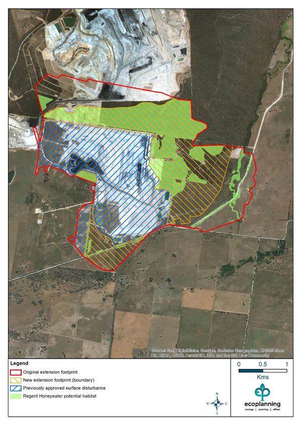
Disturbance Limits Approach
                                                                      Tarrawonga Coal Mine

Glossary and abbreviations
ACRONYM   DESCRIPTION

BBS       Brigalow Belt South

BMP       Biodiversity Management Plan

CEEC      Critically Endangered Ecological Community

DA        Development Application

EPBC      Commonwealth Environmental Protection and Biodiversity Conservation Act 1999

IBRA      Interim Biogeographic Regionalisation for Australia

LGA       Local Government Area

LP        Liverpool Plains

MNES      Matter of National Environmental Significance

NSW       New South Wales

PA        Project Approval

TCPL      Tarrawonga Coal Pty Ltd

                                                                                         v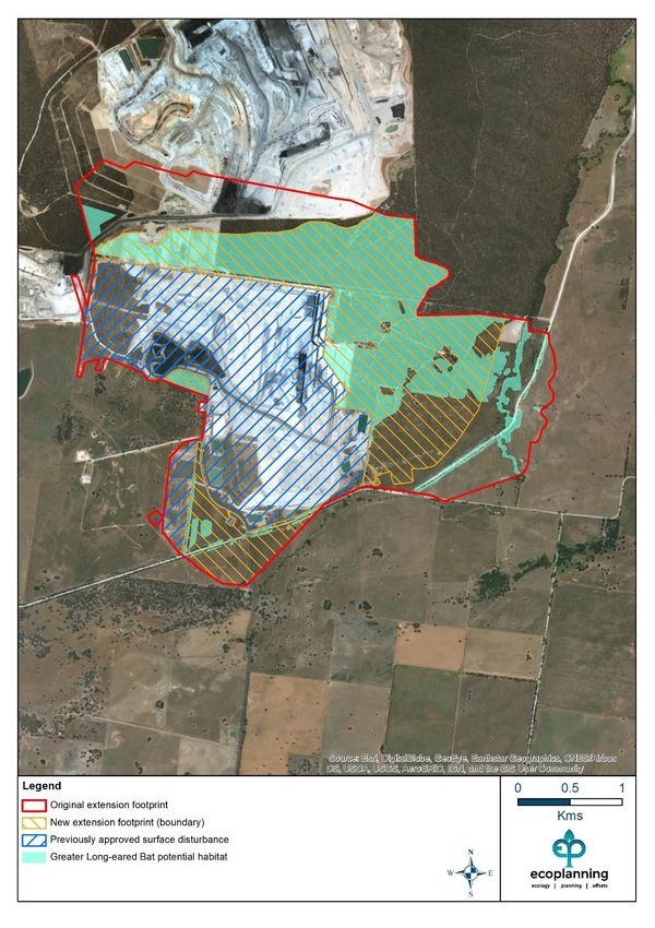
Disturbance Limits Approach
                                                                                      Tarrawonga Coal Mine

1. Introduction
1.1 Purpose of this report and legislative context
Conditional approval for this expansion of Tarrawonga coal mine was granted on 11 March 2013
(Tarrawonga Coal Mine Extension, NSW [EPBC2011/5923]) by the Commonwealth
Government. Condition 3 (a & b) of the approval under the Commonwealth Environment
Protection and Biodiversity Conservation Act 1999 (EPBC Act) (Table 1.1), requires that the
person taking the action must:

      •       Limit the maximum disturbance for a range of Matters of National Environmental
              Significance (MNES) values being impacted by the proposed extension
      •       Provide an independent analysis that demonstrates the maximum disturbance limits
              which will minimise impacts on the relevant MNES.

Table 1.1: Summary of condition 3a and 3b (EPBC 2011/5923).

 Condition 3: The person taking the action must submit to the Minister for          Section in this report
 approval within three months of commencement of construction, an                   where condition is met
 approach that:
 a        Limits the maximum disturbance (in hectares) specified for each of        Section 3.2; Section 4
          the years 5, 10, 15 and 17 from the date of this approval of the White
          Box—Yellow Box—Blakely's Red Gum Grassy Woodland and
          Derived Native Grassland ecological community and the habitat or
          potential habitat for the regent honeyeater, swift parrot and greater
          long-eared bat
 b        Incorporates an analysis, undertaken by independent ecological            Section 3.1; Section 4
          experts approved by the Department, that demonstrates the
          maximum disturbance limits which will minimise any impacts on
          relevant matters of national environmental significance
 c        demonstrates collaboration with the person taking the action to           Evidence of
          develop and operate the Boggabri Coal Project (EPBC 2009/5256)            collaboration to be
          and the person taking the action to develop and operate the Maules        provided by Whitehaven
          Creek Coal Project (EPBC 2010/5566), in order to minimise                 Coal Limited. Not
          progressive project area disturbance limits across all three sites. The   discussed in this DLA
          progressive disturbance limits are to be reflected in the development
          of the Leard Forest Mining Precinct Biodiversity Strategy

This report has been prepared to satisfy condition 3a and 3b by:

      (1) providing an analysis that demonstrates the maximum approved disturbance limits
      which aim to minimise impacts on relevant MNES, and

      (2) identifying the maximum disturbance anticipated for years 5, 10, 15 and 17. The report
      has been prepared to include only those MNES relevant to the Project, including:

            • The ecological community known as White Box-Yellow Box-Blakely's Red Gum
               Grassy Woodland and Derived Native Grassland ecological community (referred
               to in this report as Box-Gum Grassy Woodland) – critically endangered

                                                                                                             1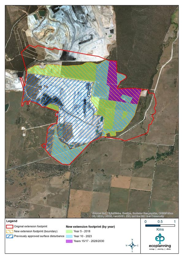
Disturbance Limits Approach
                                                                         Tarrawonga Coal Mine

         • Potential habitat for Regent Honeyeater (Anthochaera phrygia) – critically
            endangered
         • Potential habitat Swift Parrot (Lathamus discolour) – critically endangered
         • Potential habitat Greater Long-eared bat (Nyctophilus corbeni) – vulnerable

In satisfying Condition 3a and Condition 3b an assessment of the total amount of impact
associated with the approval has been completed. The amount of habitat available for each
MNES, within the surrounding ‘region’, has also been calculated.

To satisfy the requirements of Condition 3a and Condition 3b (Table 1.1), the following tasks
have been undertaken:

     •     Literature review to determine the amount of disturbance approved for each MNES
           as part of the extension
     •     Confirmation of the extension disturbance footprint assessed in the original impact
           assessment for each MNES
     •     Confirmation of any changes to the extension disturbance footprint, and calculation
           of the new area of disturbance proposed
     •     Calculation of the area of available habitats for each MNES in the surrounding
           Interim Bioregionalisation of Australia (IBRA) region and subregion using best
           available data and information.

Using the above information, the maximum disturbance limits for each MNES were assessed
and their suitability reviewed. This DLA provides an updated assessment of the proposal
following from Ecoplanning (2016).

1.2 Background
The Tarrawonga Coal Mine (Tarrawonga), managed by Whitehaven Coal Mining Limited, is
located approximately 15 km north east of Boggabri and 42 km north west of Gunnedah (Figure
1.1 and Figure 1.2) in the state of NSW (ELA 2015). The site is located partially within the
boundaries of Leard State Forest and is situated wholly within the Narrabri Local Government
Area (LGA). Mining operations are undertaken by Tarrawonga Coal Pty Ltd (TCPL) (ELA 2015).

The mine commenced operations in 2006, known then as East Boggabri Coal Mine (ELA 2015).
Since that time an extension within Mining Lease (ML) 1579 was granted (2010 - DA 88-4-2005
MOD 1) (ELA 2015), with conditional approval also granted for a subsequent proposed
extension (the subject of this report - NSW State Government (PA 11_0047) and
Commonwealth Government (EPBC 2011/5923)) (ELA 2015). Construction of the current
expansion of Tarrawonga commenced in March 2014.

1.2.1 Approved clearing
Maximum clearing limits for each MNES are set in the Commonwealth Government’s approval
(EPBC 2011/5923). Conditions 1 and 2 of EPBC 2011/5923 allow TCPL to complete the
following clearing as part of the current extension:

1. The person taking the action must not clear more than 13 ha of the EPBC listed White Box—
Yellow Box—Blakely's Red Gum Grassy Woodland and Derived Native Grassland critically
endangered ecological community within the Tarrawonga Coal Extension project area;

                                                                                            2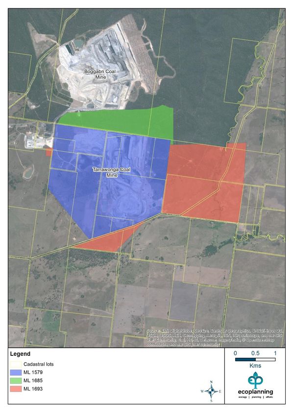
Disturbance Limits Approach
                                                                  Tarrawonga Coal Mine

2. The person taking the action must not clear more than:

   a) 279 ha of habitat for the Regent Honeyeater (Anthochaera phrygia: formerly
      Xanthomyza phrygia)
   b) 54 ha of habitat for the Swift Parrot (Lathamus discolor)
   c) 334 ha of habitat for the Greater Long-eared Bat (Nyctophilus corbeni)
      within the Tarrawonga Coal Extension project area.

                                                                                     3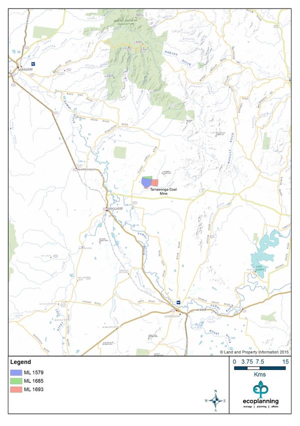
Disturbance Limits Approach
                                          Tarrawonga Coal Mine

Figure 1.1: Tarrawonga Coal Mine.

                                                             4
Disturbance Limits Approach
                                                   Tarrawonga Coal Mine

Figure 1.2: Tarrawonga Coal Mine locality.

                                                                      5
Disturbance Limits Approach
Tarrawonga Coal Mine
This report reviews the maximum allowable clearing limits displayed above to determine their
suitability. A new extension footprint has now also been prepared by TCPL, which has reduced
the amount of vegetation and habitat to be impacted by TCPL between 2018 (year 5) and 2030
(year 17). This information has been reviewed and assessed as part of this report.
1.2.2 Rehabilitation and offsetting
TCPL propose to undertake staged rehabilitation and revegetation which follows the annual
clearing within the project area. The progressive rehabilitation will allow for both
woodland/forest associations and agricultural land which contain predominantly native grasses
(RSCES 2011).
The planned use of hollows, logs and nest boxes will enhance the habitat available within the
rehabilitated lands and will improve the capacity of the rehabilitated land to provide habitat for
hollow and ground log dependent fauna (RSCES 2011).
Revegetation of woodland areas will utilise local species consistent with the Box-Gum Grassy
Woodland critically endangered ecological community (CEEC), including a White Box
overstorey and appropriate understorey (RSCES 2011). Approximately 752 ha of
woodland/forest will be rehabilitated, and over the medium to long term (greater than 10 years)
730 ha of the post-mine landform is likely to be on a trajectory towards s self-sustaining
ecosystem (RSCES 2011). The proposed timing of rehabilitation is provided in Table 1.2.
Table 1.2: Proposed timing of rehabilitation (adapted from RSCES 2011).
Year Land clearance area (ha)1 Rehabilitation area (ha)*
0 441 322
2 503 176
4 579 295
6 652 437
12 859 551
16 925 730
Completion 1,113 1,1133, 4
* Woodland/forest plus area for agricultural land use outcomes.
1 Excludes Project disturbance that overlaps the proposed Boggabri Coal Mine surface development extent.
2 Included in current existing/approved land clearance area of 441 ha.
3 Includes final void area of 115 ha.
4
Includes sediment basins/farm dams, permanent flood bund and road realignments that are retained.
Offsets are to be provided on the Willeroi offset area, located approximately 20 km north east
of the Tarrawonga Coal Mine, 39 km north east of Boggabri and 57 km north of Gunnedah
(RSCES 2011) (Figure 1.3). The site is adjacent to the Mt Kaputar National Park and appears
to have been predominantly used as a grazing property in the past (RSCES 2011). The total
size of the offset site 1,660 ha.
6Disturbance Limits Approach
Tarrawonga Coal Mine
Figure 1.3: Willeroi offset area location.
7Disturbance Limits Approach
Tarrawonga Coal Mine
2. Methods
2.1 Literature and data review
A literature and data review was initially undertaken to obtain quantitative data for the impact
and offset calculations and the regional vegetation and species habitat assessment. The
documents reviewed are listed below:
• Tarrawonga Coal Project Environmental Assessment:
o Appendix E - Fauna Assessment, including Attachment E Willeroi Fauna
Report (RSCES 2011)
o Appendix F - Flora Assessment, including Attachment C Offset Strategy
(FloraSearch 2011b)
• Tarrawonga Coal Mine Biodiversity Management Plan (Whitehaven Coal Limited
2015)
• Mining Operations Plan: Tarrawonga Coal Mine. 1 November 2015 to 30 December
2020 (SLR 2015)
• Biodiversity Offset Management Plan: Whitehaven Regional Biodiversity Offset Site
(Eco Logical Australia 2013a)
• Tarrawonga Coal Mine White-box Yellow-box Blakely’s Red-gum Woodland
Endangered Ecological Community: Implementation Plan (Whitehaven Coal
Limited 2015)
• EPBC Act Assessment of the Impact on Tylophora linearis through the Loss of
Habitat Associated with Tarrawonga Open Cut Coal Mine (Hunter Eco 2016)
2.2 Impact calculations
An assessment of the amount of each MNES to be impacted was conducted as part of this
assessment.
The ‘original extension footprint’ (EPBC 2011/5923) is shown in Figure 2.1. Since conditional
approval was granted, the area to be impacted by the Project has been refined, with less
vegetation (including CEEC and associated threatened species habitat) now to be removed. A
‘new extension footprint’ was provided by TCPL for 2018 (year 5), 2023 (year 10), 2028 (year 15)
and 2030 (year 17) (Figure 2.1). Note that no clearing takes place between year 15 and year
17, therefore 2028 and 2030 are combined into a single polygon for mapping purposes.
The ‘previously approved surface disturbance’ is also displayed in Figure 2.1. The vegetation
cleared within this area is not subject to this DLA.
The new extension footprint has been analysed against the habitat and vegetation mapping
within the extension footprint to provide disturbance amounts for the Project for each MNES.
The areas disturbed using the new extension footprint have then been compared to the
maximum area approved to be cleared under EPBC 2011/5923, which was based on impacts
expected using the original extension footprint. The updated impact calculations are presented
in Section 3 for each MNES. In all cases the area to be cleared for each MNES is less than
the maximum disturbance limit identified in EPBC 2011/5923.
8Disturbance Limits Approach
Tarrawonga Coal Mine
To complete the assessment GIS analysis was conducted to calculate the area of each MNES
impacted within the new extension footprint provided. In order to calculate the area of MNES
impacted the existing vegetation map produced for the Project site (FloraSearch 2011a) was
combined with the new extension footprint provided by TCPL, and the area of vegetation or
habitat within the new extension footprint calculated. Each MNES was then associated with one
or more mapped vegetation types.
Table 2.1 provides the associations for the impact site for the new extension footprint. Note,
the associations used are identical to those use for the environmental assessment prepared for
the project (FloraSearch 2011a and 2011b).
9Disturbance Limits Approach
Tarrawonga Coal Mine
Figure 2.1: Original extension footprint and new extension footprint.
10Disturbance Limits Approach
Tarrawonga Coal Mine
Table 2.1: MNES vegetation and habitat associations within the Project site.
Greater Box-Gum
Vegetation Swift Regent
Vegetation type and condition class Long- Grassy
code Parrot Honeyeater
eared Bat Woodland
1 White Cypress Pine - Narrow-leaved Ironbark shrubby open forest Y Y
White Cypress Pine - Narrow-leaved Ironbark shrubby open forest - White Cypress
1a Pine regeneration Y
1b White Cypress Pine - Narrow-leaved Ironbark shrubby open forest - Regeneration Y Y
White Cypress Pine - Narrow-leaved Ironbark shrubby open forest - Derived Native
1c Grassland
2 White Box - White Cypress Pine shrubby woodland Y Y Y
2b White Box - White Cypress Pine shrubby woodland – Semi-cleared and regenerating Y Y Y
3 White Box - White Cypress Pine grassy woodland Y Y Y Y
3a White Box - White Cypress Pine grassy woodland - White Cypress Pine regeneration Y Y Y Y
3b White Box - White Cypress Pine grassy woodland – Semi-cleared and regenerating Y Y Y
3c White Box - White Cypress Pine grassy woodland - Derived Native Grassland Y
4 Pilliga Box - Poplar Box - White Cypress Pine grassy open woodland Y Y
Pilliga Box - Poplar Box - White Cypress Pine grassy open woodland - Derived
4c Native Grassland
5 Bracteate Honeymyrtle low riparian forest Y Y
6 Cleared land
11Disturbance Limits Approach
Tarrawonga Coal Mine
2.3 Regional species habitat assessment
The available habitat for Regent Honeyeater, Swift Parrot and Greater Long-eared Bat was
calculated for the Liverpool Plains (LP) IBRA subregion and the Brigalow Belt South (BBS) IBRA
region. The total area of the LP IBRA subregion is approximately 941,752 ha, and is within the
larger BBS IBRA region which covers approximately 5,623,054 ha.
Best available vegetation data was sourced from the SEED portal
(https://www.seed.nsw.gov.au/) for the LP and BBS IBRA region. Layers sourced include three
vegetation maps prepared as part of the State Vegetation Type Map, specifically the Border
Rivers Gwydir / Namoi Region Version 2.0 (VIS 4467), Central West / Lachlan Region Version
1.4 (VIS 4468) and Western Region v1.0 (VIS 4492). The south eastern corner of the BBS was
not covered by a layer from the State Vegetation Type Map, therefore the Greater Hunter Native
Vegetation Mapping v4.0 (VIS 3855) was used.
The four regional vegetation maps were combined in ArcGIS and the seamless layer clipped to
the BBS IBRA region boundary. Species associations to mapped Plant Community Types
(PCTs) were then made based on the data contained in the Threatened Biodiversity Data
Collection (OEH 2019), with each mapped vegetation community categorised either as ‘habitat
listed in profile’ or ‘not habitat’. Further assessment was then done for each species to
determine which subregions within the BBS each species was likely to be found, again based
on data from the Threatened Biodiversity Data Collection (OEH 2019).
The area of impacted habitat (both for the maximum area approved to be cleared (EPBC
2011/5923) and the new extension footprint) was then assessed against the amount of habitat
mapped in both the LP IBRA subregion and the BBS IBRA region.
A similar approach was adopted for mapping Box-Gum Grassy Woodland, with vegetation
associations contained within the BioNet Vegetation Classification (OEH 2019) used to identify
those PCTs which are potentially consistent with White Box—Yellow Box—Blakely's Red Gum
Grassy Woodland and Derived Native Grassland within the compilation vegetation data set.
Note that, due to limitations in the vegetation mapping used, no identification of DNG was
possible within the broader IBRA region or subregion.
12Disturbance Limits Approach
Tarrawonga Coal Mine
3. Results
3.1 Disturbance limits assessment
As outlined in Section 1, conditions 1 and 2 of EPBC 2011/5923 allow TCPL to complete the
following clearing within the Tarrawonga Coal Extension project area as part of the current
extension:
• 13 ha of the EPBC listed White Box—Yellow Box—Blakely's Red Gum Grassy
Woodland and Derived Native Grassland (Box Gum Grassy Woodland)
• 279 ha of habitat for the Regent Honeyeater
• 54 ha of habitat for the Swift Parrot
• 334 ha of habitat for the Greater Long-eared Bat
To compare the above maximum disturbance limits to what is now proposed, the new extension
footprint provided by TCPL for 2018 (year 5), 2023 (year 10), 2028 (year 15) and 2030 (year 17)
was analysed against the habitat mapping available for the mine extension. For reference the
total area of mapped habitat for each species is:
• Box-Gum Grassy Woodland – 12.9 ha
• Regent Honeyeater – 272.2 ha
• Swift Parrot – 53.4 ha
• Greater Long-eared Bat – 327.1 ha
Table 3.1 provides a summary of the analysis results for each clearing period, and provides the
total area of clearing for each MNES in years 5, 10 and 15/17. The total clearing calculated is:
• Box-Gum Grassy Woodland – 12.9 ha
• Regent Honeyeater – 248.7 ha
• Swift Parrot – 53.4 ha
• Greater Long-eared Bat – 298.5 ha
Typical of mining expansions, proportionally more vegetation clearing occurs in earlier years
than later years. Note, due to habitat for MNES overlapping in some locations, the statistics in
Table 3.1 cannot be summed to provide a total impact amount.
Table 3.1: Summary of MNES clearing, by year, for the proposed mine extension (new extension footprint).
2018 2023 2028/30 Total area of
MNES
(Year 5)* (Year 10)* (Years 15/17)* clearing (ha)*
Box-Gum Grassy
6.2 6.7 0 12.9
Woodland
Regent
132.3 76.3 40.1 248.7
Honeyeater
Swift Parrot 48.7 4.7 0 53.4
Greater Long-
132.6 101.6 64.3 298.5
eared Bat
* Cannot be summed to calculate a total area of clearing as clearing overlaps in some cases.
13Disturbance Limits Approach
Tarrawonga Coal Mine
More detailed analysis is provided in Table 3.3, which provides a breakdown of clearing by
vegetation type and MNES and identifies the habitat types where multiple species are impacted
by the same clearing event. In total 325.2 ha of native vegetation clearing will occur due to the
extension of the Tarrawonga Coal Mine based on the new extension footprint.
A comparison of the proposed clearing against the maximum disturbance limits identified in
conditions 1 and 2 of EPBC 2011/5923 was undertaken, with the results displayed in Table 3.2.
For all MNES the total clearing now calculated is less than the maximum disturbance limit set
by conditions 1 and 2 of EPBC 2011/5923.
Table 3.2: Comparison of maximum disturbance limits and proposed area of clearing for MNES.
Area of clearing in year 5, year 10 and year 15/17 Difference between
from proposed Tarrawonga Mine extension (new proposed area of
extension footprint) Maximum clearing (new
MNES disturbance extension
2028/30 Area of limit (ha)* footprint) and max.
2018 2023 (Year
(Years clearing disturbance limit
(Year 5)* 10)*
15/17)* (ha)* (ha)*
Box-Gum
Grassy 6.2 6.7 0 12.9 13 -0.1
Woodland
Regent
132.3 76.3 40.1 248.7 279 -30.3
Honeyeater
Swift Parrot 48.7 4.7 0 53.4 54 -0.6
Greater
Long-eared 132.6 101.6 64.3 298.5 334 -35.5
Bat
* Cannot be summed to calculate a total area of clearing as clearing overlaps in some cases.
Based on the above analysis, the progressive rehabilitation planned for the mine, appropriate
offsetting and the amount of MNES habitat in the surrounding region (analysis below in
Section 3.2) the maximum disturbance limit for each MNES considered is assessed as suitable
and the minimum practical during each sequence of mine clearance.
14Disturbance Limits Approach
Tarrawonga Coal Mine
Table 3.3: Details of MNES clearing, by year, for the proposed mine extension (new extension footprint).*
Greater White Box- Impact sequence by year
Veg Swift Regent
Vegetation type and condition class Long- Gum Grassy
code Parrot Honeyeater 2018 2023 2028/30 Area of
eared Bat Woodland
(Year 5) (Year 10) (Years 15/17) clearing (ha)
White Cypress Pine - Narrow-leaved Ironbark shrubby
1 Y Y 78.8 62.1 40.1 180.9
open forest
White Cypress Pine - Narrow-leaved Ironbark shrubby
1a Y 0.3 25.2 24.2 49.8
open forest - White Cypress Pine regeneration
White Cypress Pine - Narrow-leaved Ironbark shrubby
1b Y Y 4.8 4.3 0.0 9.1
open forest - Regeneration
White Cypress Pine - Narrow-leaved Ironbark shrubby
1c 2.3 5.0 7.1 14.5
open forest - Derived Native Grassland
2 White Box - White Cypress Pine shrubby woodland Y Y Y 37.8 2.3 0.0 40.1
White Box - White Cypress Pine shrubby woodland –
2b Y Y Y 4.7 0.0 0.0 4.7
Semi-cleared and regenerating
3 White Box - White Cypress Pine grassy woodland Y Y Y Y 3.0 2.4 0.0 5.4
White Box - White Cypress Pine grassy woodland -
3a Y Y Y Y 3.2 0.0 0.0 3.2
White Cypress Pine regeneration
White Box - White Cypress Pine grassy woodland –
3b Y Y Y 0.0 1.6 0.0 1.6
Semi-cleared and regenerating
White Box - White Cypress Pine grassy woodland -
3c Y 0.0 2.8 0.0 2.8
Derived Native Grassland
Pilliga Box - Poplar Box - White Cypress Pine grassy
4 Y Y 0.1 3.6 0.0 3.7
open woodland
Pilliga Box - Poplar Box - White Cypress Pine grassy
4c 0.4 9.1 0.0 9.5
open woodland - Derived Native Grassland
5 Bracteate Honeymyrtle low riparian forest Y Y 0 0 0 0.0
Grand total 135.3 118.5 71.5 325.2
* Rounding errors apply
15Disturbance Limits Approach
Tarrawonga Coal Mine
3.2 Detailed MNES review
3.2.1 White Box-Yellow Box-Blakely's Red Gum Grassy Woodland
Literature and data review
In addition to literature cited in Section 2.1, the following resources were utilised in the literature
and database review for Regent Honeyeater:
• NSW Office of Environment and Heritage (OEH 2019) Threatened species website.
Accessed at http://www.environment.nsw.gov.au/threatenedspecies/
• OEH Threatened Biodiversity Data Collection. Accessed at:
http://www.environment.nsw.gov.au/AtlasApp/UI_Modules/TSM_/Default.aspx?a=1
• National Recovery Plan for White Box - Yellow Box - Blakely’s Red Gum Grassy
Woodland and Derived Native Grassland. Department of Environment, Climate
Change and Water NSW, Sydney (DECCW 2011)
• Advice to the Minister for the Environment and Heritage from the Threatened
Species Scientific Committee (TSSC) on Amendments to the List of Ecological
Communities under the EPBC Act TSSC (2009)
Text is taken directly from the above sources unless noted otherwise.
Distribution, ecology and habitat
Box-Gum Grassy Woodlands and Derived Grasslands are characterised by a species-rich
understorey of native tussock grasses, herbs and scattered shrubs, and the dominance, or prior
dominance, of White Box, Yellow Box or Blakely’s Red Gum trees. The tree-cover is generally
discontinuous and consists of widely-spaced trees of medium height in which the canopies are
clearly separated (Yates & Hobbs 1997). In its pre-1750 state, this ecological community was
characterised by:
• a ground layer dominated by tussock grasses;
• an overstorey dominated or co-dominated by White Box, Yellow Box or Blakely’s
Red Gum, or Grey Box in the Nandewar bioregion; and,
• a sparse or patchy shrub layer.
Associated, and occasionally co-dominant, trees include, but are not restricted to: Grey Box
(Eucalyptus microcarpa), Fuzzy Box (E. conica), Apple Box (E. bridgesiana), Red Box
(E. polyanthemos), Red Stringybark (E. macrorhyncha), White Cypress Pine (Callitris
glaucophylla), Black Cypress Pine (C. enderlicheri), Long-leaved Box (E. gonicalyx), New
England Stringybark (E. calignosa), Brittle Gum (E. mannifera), Candlebark (E. rubida), Argyle
Apple (E. cinerea), Kurrajong (Brachychiton populneus) and Drooping She-oak (Allocasuarina
verticillata). This ecological community occurs in areas where rainfall is between 400 and 1200
mm per annum, on moderate to highly fertile soils at altitudes of 170 metres to 1200 metres
(NSW Scientific Committee 2002).
Grazing can also have indirect effects upon other ground layer species through soil disturbance
and physical changes to the soil such as compaction, nutrient enrichment, reduced water
infiltration and erosion. These changes to the soil can facilitate and maintain weed invasions
and make soil conditions unsuitable for native species regeneration (Prober et al. 2002a &
16Disturbance Limits Approach
Tarrawonga Coal Mine
2002b; Yates & Hobbs 1997). As a consequence of these pressures, there are only a small
number of areas remaining that retain a highly diverse understorey dominated by native,
perennial tussock grasses. These areas are extremely rare, and usually quite small in size
(Prober & Thiele 1995). They have often been cleared of trees and may no longer possess an
overstorey. However, these remnants can be relatively intact despite the absence of trees.
Threats
Thiele and Prober (2000) estimated that less than 0.1% of Grassy White Box Woodlands (a
component of the Box – Gum Grassy Woodland and Derived Grassland ecological community)
remains in a near-intact condition. Much of the original extent of the Box – Gum Grassy
Woodland and Derived Grassland ecological community has been cleared for agriculture. In
most of the areas that remain, grazing and pasture-improvement have effectively removed the
characteristic understorey, leaving only the overstorey trees with an understorey dominated by
exotic species (McIntyre et al. 2002). In these areas, grazing has also largely prevented the
regeneration of the overstorey species (Sivertsen 1993). Due to the high levels of clearing that
have taken place, and continued grazing, large areas of healthy, regenerating overstorey are
rare.
The following threats to the recovery of this species have been identified by OEH (2016):
• Clearing, degradation and fragmentation of remnants for agricultural, forestry,
infrastructure and residential development.
• Continuous heavy grazing and trampling of remnants by grazing stock, resulting in
losses of plant species (simplification of the understorey and groundlayer and
suppression of overstorey), erosion and other soil changes (including increased
nutrient status).
• Invasion of remnants by non-native plant species, including noxious weeds, pasture
species and environmental weeds, including garden escapes, olives and pines.
• Invasion of remnants by feral animals resulting in the loss or modification of habitat.
• Disturbance and clearance of remnants during road, rail and infrastructure
maintenance and upgrades.
• Harvesting of firewood (either living or standing dead, including material on the
ground).
• Collection of on-ground woody debris in the guise of a 'clean-up'.
Regional vegetation assessment
The regional habitat assessment for Box-Gum Grassy Woodland CEEC found approximately
52,584 ha of habitat potentially available across the Liverpool Plains and a total of 597,532 ha
within the Brigalow Belt South IBRA subregions. When assessed against the currently proposed
footprint this would equate to the equivalent ofDisturbance Limits Approach
Tarrawonga Coal Mine
Figure 3.1: Box-Gum Grassy Woodland CEEC (RSCES 2011).
18Disturbance Limits Approach
Tarrawonga Coal Mine
Table 3.4: Regional habitat assessment for Box-Gum Grassy Woodland CEEC.*
Area to be cleared (new Maximum area approved to
extension footprint) be cleared (EPBC 2011/5923)
Available
Region
habitat (ha)
Regional Regional
Area (ha) Area (ha)
impact (%) impact (%)
Brigalow Belt
South IBRA 597,532Disturbance Limits Approach
Tarrawonga Coal Mine
coastal forests in NSW and eastern Victoria. Particularly when breeding, Regent Honeyeaters
require access to nectar or another form of sugary plant exudate such as lerps or honeydew. A
few species of Eucalyptus and a mistletoe (Amyema cambagei) seem to be important in
providing reliable and relatively predictable nectar flows. Lack of access to these dependable
nectar flows at critical times, due to clearance of the most fertile stands, the poor health of many
remnants, and competition for nectar from other honeyeaters, may be a major cause of the
decline of this species.
The Regent Honeyeater mainly inhabits temperate woodlands and open forests of the inland
slopes of south-east Australia. Birds are also found in drier coastal woodlands and forests in
some years. Once recorded between Adelaide and the central coast of Queensland, its range
has contracted dramatically in the last 30 years to between north-eastern Victoria and south-
eastern Queensland. There are only three known key breeding regions remaining: north-east
Victoria (Chiltern-Albury), and in NSW at Capertee Valley and the Bundarra-Barraba region. In
NSW the distribution is very patchy and mainly confined to the two main breeding areas and
surrounding fragmented woodlands.
Every few years non-breeding flocks are seen foraging in flowering coastal Swamp Mahogany
and Spotted Gum forests, particularly on the central coast and occasionally on the upper north
coast. Birds are occasionally seen on the south coast. Regent Honeyeaters have been recorded
in urban areas around Albury where woodlands tree species such as Mugga Ironbark and
Yellow Box were planted >20 years ago.
The Regent Honeyeater is a generalist forager, although it feeds mainly on the nectar from a
relatively small number of eucalypts that produce high volumes of nectar. Key eucalypt species
include Mugga Ironbark, Yellow Box, White Box and Swamp Mahogany. Other tree species may
be regionally important. For example the Lower Hunter Spotted Gum forests have recently been
demonstrated to support regular breeding events. Flowering of associated species such as Thin-
leaved Stringybark Eucalyptus eugenioides and other Stringybark species, and Broad-leaved
Ironbark E. fibrosa can also contribute important nectar flows at times. Nectar and fruit from the
mistletoes Amyema miquelii, A. pendula and A. cambagei are also utilised. When nectar is
scarce lerp and honeydew can comprise a large proportion of the diet. Insects make up about
15% of the total diet and are important components of the diet of nestlings.
Colour-banding of Regent Honeyeater has shown that the species can undertake large-scale
nomadic movements in the order of hundreds of kilometres. However, the exact nature of these
movements is still poorly understood. It is likely that movements are dependent on spatial and
temporal flowering and other resource patterns. To successfully manage the recovery of this
species a full understanding of the habitats used in the non-breeding season is critical.
Threats
The following threats to the recovery of this species have been identified by OEH (2016):
• Historical loss, fragmentation and degradation of habitat from clearing for
agricultural and residential development, particularly fertile Yellow Box-White Box-
Blakely's Red Gum woodlands.
• Continuing loss of key habitat tree species and remnant woodlands from major
developments (mining and agricultural), timber gathering and residential
developments.
20Disturbance Limits Approach
Tarrawonga Coal Mine
• Key habitats continue to degrade from lack of recruitment of key forage species and
loss of paddock trees and small remnants increasingly fragmenting the available
habitat
• Suppression of natural regeneration of overstorey tree species and shrub species
from overgrazing. Riparian gallery forests have been particularly impacted by
overgrazing.
• Competition from larger aggressive honeyeaters, particularly Noisy Miners, Noisy
Friarbirds and Red Wattlebirds.
• The small population size and restricted habitat availability make the species highly
vulnerable to extinction via stochastic processes and loss of genetic diversity, and
reduced ability to compete and increased predation and reduced fledging rates.
• Egg and nest predation by native birds and mammals
• Inappropriate forestry management practices that remove large mature resource-
abundant trees. Firewood collection and harvesting in Box-Ironbark woodlands
can also remove important habitat components.
Regional vegetation and species habitat assessment
The regional habitat assessment for Regent Honeyeater found approximately 127,706 ha of
habitat potentially available across the Liverpool Plains and a total of 665,066 ha within the
Brigalow Belt South IBRA subregions. When assessed against the currently proposed footprint
this would equate to the equivalent of 0.04% of the regional habitat potentially available to the
Regent Honeyeater, and 0.04% for the maximum approved clearing (Table 3.5 and Figure 3.2).
Table 3.5: Regional habitat assessment for Regent Honeyeater.*
Area to be cleared (new Maximum area approved to
extension footprint) be cleared (EPBC 2011/5923)
Available
Region
habitat (ha)
Regional Regional
Area (ha) Area (ha)
impact (%) impact (%)
Brigalow Belt
South IBRA 665,066 0.04% 0.04%
region
248.7 279
Liverpool
Plains IBRA 127,706 0.19% 0.22%
subregion
* Rounding errors apply
Disturbance limits approach conclusion
The maximum area approved to be cleared for the project is 279 ha of potential Regent
Honeyeater habitat. The new extension footprint for the project is now estimated to impact on
248.7 ha of Regent Honeyeater habitat, 30.3 ha less than the maximum disturbance limit.
Analysis into the amount of potential Regent Honeyeater habitat within the surrounding IBRA
region found that the impact to the available habitat was the equivalent of 0.04% of the total
habitat.
21Disturbance Limits Approach
Tarrawonga Coal Mine
Based on the above analysis the maximum disturbance limit for the Regent Honeyeater (279 ha)
is assessed as suitable. The impacts proposed (248.7 ha) are also considered to be the
minimum practical during each sequence of mine clearance.
22Disturbance Limits Approach
Tarrawonga Coal Mine
Figure 3.2: Potential Regent Honeyeater habitat (RSCES 2011).
23Disturbance Limits Approach
Tarrawonga Coal Mine
3.2.3 Swift Parrot
Literature and data review
In addition to literature cited in Section 2.1, the following resources were utilised in the literature
and database review for Swift Parrot:
• NSW Office of Environment and Heritage (OEH 2019) Threatened species website.
Accessed at http://www.environment.nsw.gov.au/threatenedspecies/
• OEH Threatened Biodiversity Data Collection. Accessed at:
http://www.environment.nsw.gov.au/AtlasApp/UI_Modules/TSM_/Default.aspx?a=1
• Swift Parrot Recovery Plan. Department of Primary Industries, Water and
Environment, Hobart. Swift Parrot Recovery Team (2001).
Text below is taken directly from the above sources unless noted otherwise.
Distribution, ecology and habitat
The Swift Parrot breeds only in Tasmania and migrates to mainland Australia between March
and October. During winter it is semi-nomadic, foraging for lerps and nectar in flowering
eucalypts predominantly in Victoria and New South Wales, particularly in box ironbark forests
and woodlands. In Tasmania, the breeding range of the Swift Parrot is largely restricted to the
east coast within the range of the Tasmanian blue gum.
In NSW mostly occurs on the coast and south west slopes. On the mainland they occur in areas
where eucalypts are flowering profusely or where there are abundant lerp (from sap-sucking
bugs) infestations. Favoured feed trees include winter flowering species such as Swamp
Mahogany (Eucalyptus robusta), Spotted Gum (Corymbia maculata), Red Bloodwood
(C. gummifera), Mugga Ironbark (E. sideroxylon), and White Box (E. albens). Commonly used
lerp infested trees include Inland Grey Box (E. microcarpa), Grey Box (E. moluccana) and
Blackbutt (E. pilularis). They return to some foraging sites on a cyclic basis depending on food
availability.
Following winter, they return to Tasmania where they breed from September to January, nesting
in old trees with hollows and feeding in forests dominated by Tasmanian Blue Gum (Eucalyptus
globulus). The breeding season of the Swift Parrot coincides with the flowering of blue gum and
the nectar of this eucalypt is the main source of food for the parrots during breeding.
Threats
Woodlands and forests within the parrot’s over-wintering range and its restricted breeding
distribution have been fragmented and substantially reduced by land clearance for agriculture
and urban and coastal development. Forestry operations and firewood collection have also
altered the age structure of forests, resulting in the loss of older trees that provide a major food
resource as well as hollows for nesting. The swift parrot also suffers from high mortality during
the breeding season through collisions with man-made structures such as windows, wire mesh
fences and vehicles.
24Disturbance Limits Approach
Tarrawonga Coal Mine
The following threats to the recovery of this species have been identified by OEH (2016):
• Habitat loss and degradation.
• Changes in spatial and temporal distribution of habitat due to climate change.
• Reduction in food resources due to drought.
• Competition for food resources.
• Collision mortality.
• Psittacine Beak and Feather Disease (PBFD).
• Fragmentation of woodland habitat.
• Infestation by invasive weeds.
• Inappropriate fire regimes.
• Aggressive exclusion from forest and woodland habitat by over abundant Noisy
Miners.
Regional vegetation and species habitat assessment
The regional habitat assessment for Swift Parrot found approximately 146,204 ha of habitat
potentially available across the Liverpool Plains and a total of 1,661,359 ha within the Brigalow
Belt South IBRA subregions. When assessed against the new extension footprint this would
equate to the equivalent ofDisturbance Limits Approach
Tarrawonga Coal Mine
Figure 3.3: Potential Swift Parrot habitat (RSCES 2011).
26Disturbance Limits Approach
Tarrawonga Coal Mine
Disturbance limits approach conclusion
The maximum area approved to be cleared for the project is 54 ha of potential Swift Parrot
habitat. The new extension footprint for the project is now estimated to impact on 53.4 ha of
Swift Parrot habitat, which represents all habitat mapped but remains below the maximum
disturbance limit by 0.6 ha.
Analysis into the amount of potential Swift Parrot habitat within the surrounding IBRA region
found that the impact to the available habitat was the equivalent ofDisturbance Limits Approach
Tarrawonga Coal Mine
Threats
The lack of detailed information regarding the distribution, abundance and ecological
requirements of the large-eared pied bat makes an assessment of threats difficult. The main
known cause of decline in the species is the destruction of, and interference with maternity and
other roosts. Information presented in this recovery plan and in Schulz et al. (1999) identifies
other probable threats as: mining of roosts; mine induced subsidence of clifflines; disturbance
from human recreational activities; habitat disturbance by introduced animals, including
livestock; predation by introduced pests; vegetation clearing in the proximity of roosts; and fire
in the proximity of roosts.
The following threats to the recovery of this species have been identified by OEH (2016):
• Clearing and isolation of forest and woodland habitats near cliffs, caves and old mine
workings for agriculture or development.
• Loss of foraging habitat close to cliffs, caves and old mine workings from forestry
activities and too-frequent burning, usually associated with grazing.
• Damage to roosting and maternity sites from mining operations, and recreational
caving activities.
• Use of pesticides.
• Disturbance to roosting areas by goats
Regional vegetation and species habitat assessment
The regional habitat assessment for Greater Long-eared Bat found approximately 172,005 ha
of habitat potentially available across the Liverpool Plains and a total of 1,912,025 ha within the
Brigalow Belt South IBRA subregions. When assessed against the new extension footprint this
would equate to the equivalent of 0.02% of the regional habitat potentially available to the
Greater Long-eared Bat, and 0.02% for the maximum approved clearing (Table 3.7 and Figure
3.4).
Table 3.7: Regional habitat assessment for Greater Long-eared Bat.*
Area to be cleared (new Maximum area approved to
extension footprint) be cleared (EPBC 2011/5923)
Available
Region
habitat (ha)
Regional Regional
Area (ha) Area (ha)
impact (%) impact (%)
Brigalow Belt
South IBRA 1,912,025 0.02% 0.02%
region
298.5 334
Liverpool
Plains IBRA 172,005 0.17% 0.19%
subregion
* Rounding errors apply
28Disturbance Limits Approach
Tarrawonga Coal Mine
Disturbance limits approach conclusion
The maximum area approved to be cleared for the project is 334 ha of potential Greater Long-
eared Bat habitat. The new extension footprint for the project is estimated to impact on 298.5 ha
of Greater Long-eared Bat habitat, 35.5 ha less than the maximum disturbance limit.
Analysis into the amount of potential Greater Long-eared Bat habitat within the surrounding
IBRA region found that the impact to the available habitat was the equivalent of 0.02% for both
the original extension footprint and new extension footprint.
Based on the above analysis the maximum disturbance limit for the Greater Long-eared Bat
(334 ha) is assessed as suitable. The impacts proposed (298.5 ha) are also considered to be
the minimum practical during each sequence of mine clearance.
29Disturbance Limits Approach
Tarrawonga Coal Mine
Figure 3.4: Potential Greater Long-eared Bat habitat (RSCES 2011).
30Disturbance Limits Approach
Tarrawonga Coal Mine
3.2.5 Tylophora linearis
In March 2016, during pre-clearance surveys within the Tarrawonga Mine project area,
Tylophora linearis was recorded at 33 locations (ELA 2016; Hunter Eco 2016) (Figure 3.5). The
species had not previously been detected within the project footprint. Tylophora linearis is listed
as endangered under the EPBC act and is therefore considered a MNES.
The species was first described by Forster (1992) and was initially known from only four records
(Hunter Eco 2016). Records within the NSW BioNet Atlas have steadily grown over time, with
the NSW BioNet Atlas containing 602 records in 2015 (Hunter Eco 2016) and, in 2019,
containing 899 records.
Although not all records include the number of individuals present at each location, the 602
records described in Hunter Eco 2016 contain 2,337 individuals. The species is known to die
back to only underground rhizomes then resprout following sufficient rainfall (Hunter Eco 2016),
making the species particularly difficult to identify during extended periods of low rainfall.
Consent condition 30 (EPBC 2011/5923) requires that the Commonwealth Government be
notified should additional matters of MNES be recorded within the Project area. On identification
of the species within the Project footprint TCPL notified the Commonwealth Government and an
EPBC Act Assessment was completed by Hunter Eco (2016). The assessment found the
following (Hunter Eco 2016):
• Targeted surveys by Niche Environment and Heritage within Leard State Forest,
Leard Conservation Area and properties identified as offsets for the Maules Creek
coal mine in April and May 2014 identified 29,484 plants in 128 hectares (ha) of
survey transects;
• Based on the results from Niche Environment and Heritage, a Tylophora linearis
modelled population of 1.04 million plants within the region is estimated;
• It is conservatively anticipated that, due to the wide availability of suitable habitat
within the Tarrawonga Project area, up to 127.5 ha of Tylophora linearis habitat
will be cleared within the Tarrawonga Project area to 2020. This would result in
an estimated loss of approximately 11,000 plants to the year 2020. This represents
approximately 1% of the estimated total Tylophora linearis plants in the immediate
region.
• The impact to Tylophora linearis from the Tarrawonga Mine will not have a significant
impact on Tylophora linearis.
The assessment by Hunter Eco (2016) found that a significant impact to Tylophora linearis will
not occur. As such no offset is being considered for Tylophora linearis and a maximum
disturbance limits assessment was not required.
31Disturbance Limits Approach
Tarrawonga Coal Mine
Figure 3.5: Tylophora linearis records.
32Disturbance Limits Approach
Tarrawonga Coal Mine
4. Conclusion and recommendations
The analysis completed for this report included an assessment of the proposed impacts to a
number of MNES compared to that approved and a review of the habitat available at both the
sub-regional and regional scale compared to the area proposed to be cleared. Both
assessments found that the maximum disturbance limits are consistent with the those approved
for all matters of MNES.
One MNES (Tylophora linearis) not previously identified within the Tarrawonga Mine Project site
was confirmed during pre-clearance surveys. An assessment by Hunter Eco (2016) found that
a significant impact to Tylophora linearis will not occur, and consequently a disturbance limit
was not a condition of the project approval.
Although the maximum disturbance limits identified in EPBC 2011/5923 are considered suitable
a number of measures should be implemented to reduce impacts where possible. The new
extension footprint provided by TCPL for this project has reduced the impacts to occur on the
Project site.
Ongoing management and protection of the offset site will provide suitable habitat for all species
assessed in this report. Over time it is anticipated that the amount of habitat available on the
offset site will increase based on the actions required by the Biodiversity Management Plan
(BMP) (ELA 2013a).
33Disturbance Limits Approach
Tarrawonga Coal Mine
References
DSEWPC and DERM (2011). National recovery plan for the large-eared pied bat Chalinolobus
dwyeri. Report to the Department of Sustainability, Environment, Water, Population and
Communities (DSEWPC), Canberra. Department of Environment and Resource Management
(DERM).
Eco Logical Australia (2013a). Tarrawonga Biodiversity Management Plan. Prepared for
Whitehaven Coal Limited.
Eco Logical Australia (2013b). SEWPaC Referral of Proposed Action. Santos (Eastern) Pty
Ltd Energy NSW Coal Seam Gas Exploration and Appraisal Program Gunnedah Basin,
NSW.
Eco Logical Australia (2015).Tarrawonga Biodiversity Management Plan. Prepared for
Whitehaven Coal Limited.
Eco Logical Australia (2016). Tarrawonga Mine Tylophora linearis Statement of Condition –
Northern Extension Area.
FloraSearch (2011a). Tarrawonga Coal Project – Flora Assessment. Prepared for
Whitehaven Coal Pty Ltd by C.C. Bower - Principal Consultant Botanist.
FloraSearch (2011b). Vegetation of the ‘Willeroi’ Offset Area. Prepared for Whitehaven Coal
Pty Ltd by C.C. Bower - Principal Consultant Botanist.
Hunter Eco (2016). EPBC Act Assessment of the Impact on Tylophora linearis through the
Loss of Habitat Associated with Tarrawonga Open Cut Coal Mine.
NSW Department of Environment, Climate Change and Water (DECCW) (2011). National
Recovery Plan for White Box - Yellow Box - Blakely’s Red Gum Grassy Woodland and Derived
Native Grassland. NSW, Sydney.
NSW Office of Environment and Heritage (2019) Threatened species website. Accessed at
http://www.environment.nsw.gov.au/threatenedspecies/
NSW Office of Environment and Heritage (OEH 2019). Threatened Biodiversity Data
Collection. Accessed at:
http://www.environment.nsw.gov.au/AtlasApp/UI_Modules/TSM_/Default.aspx?a=1
Office of Environment and Heritage (2019). Threatened Species Profiles. Available from:
http://www.environment.nsw.gov.au/threatenedspecies/index.htm
Office of Environment and Heritage (n.d.). Spatial Data Online Access. Available from:
https://www.seed.nsw.gov.au/
Resource Strategies and Cenwest Environmental Services (2011). Tarrawonga coal project
fauna assessment.
34Disturbance Limits Approach
Tarrawonga Coal Mine
Swift Parrot Recovery Team (2001). Swift Parrot Recovery Plan. Department of Primary
Industries, Water and Environment, Hobart.
Threatened Species Scientific Committee (TSSC) (2009). Advice to the Minister for the
Environment and Heritage from the Threatened Species Scientific Committee (TSSC) on
Amendments to the List of Ecological Communities under the EPBC Act.
Victorian Department of Natural Resources and Environment (DNRE) (1999). Regent
Honeyeater Recovery Plan 1999 – 2003. Prepared on behalf of the Regent Honeyeater
Recovery Team by Peter Menkhorst, Natasha Schedvin and David Geering. Parks, Flora and
Fauna Division, DNRE,
35You can also read