Domain-invariant NBV Planner for Active Cross-domain Self-localization
←
→
Page content transcription
If your browser does not render page correctly, please read the page content below
Domain-invariant NBV Planner for Active Cross-domain Self-localization
                                                                                                         Tanaka Kanji

                                            Abstract— Pole-like landmark has received increasing at-
                                         tention as a domain-invariant visual cue for visual robot
                                         self-localization across domains (e.g., seasons, times of day,
                                         weathers). However, self-localization using pole-like landmarks
arXiv:2102.11530v1 [cs.CV] 23 Feb 2021

                                         can be ill-posed for a passive observer, as many viewpoints
                                         may not provide any pole-like landmark view. To alleviate
                                         this problem, we consider an active observer and explore a
                                         novel “domain-invariant” next-best-view (NBV) planner that
                                                                                                                                                          (b)                 (c)
                                         attains consistent performance over different domains (i.e.,
                                         maintenance-free), without requiring the expensive task of
                                         training data collection and retraining. In our approach, a novel
                                         multi-encoder deep convolutional neural network enables to
                                         detect domain invariant pole-like landmarks, which are then
                                         used as the sole input to a model-free deep reinforcement
                                         learning -based domain-invariant NBV planner. Further, we
                                         develop a practical system for active self-localization using
                                         sparse invariant landmarks and dense discriminative land-
                                         marks. In experiments, we demonstrate that the proposed
                                         method is effective both in efficient landmark detection and
                                         in discriminative self-localization.

                                                                 I. I NTRODUCTION

                                            Cross-domain self-localization is the problem of esti-
                                         mating a robot pose given a history of sensor readings
                                                                                                                                   (a)                               (d)
                                         including visual images/odometry data, with respect to an
                                         environment map that was previously collected in different                  Fig. 1. The domain-invariant next-best-view (NBV) planner takes a live
                                         domains (e.g., weathers, seasons, times of the day). A large                view image and plans the NBV that maximizes the possibility of true-
                                                                                                                     positive detection of pole-like landmarks, which are then used as the
                                         body of self-localization literature focuses on designing or                invariant coordinate system for spatial BoW scene model and matching.
                                         training a landmark detector that is robust against domain                  (a) An input live image (top) and an NBV view at the planned viewpoint
                                         shifts [1]–[3]. However, the problem of designing/training                  (bottom). A query view (b) and a reference view (c) are aligned with the
                                                                                                                     invariant coordinate system (d).
                                         such a domain-invariant landmark detector is essentially ill-
                                         posed when current live images are from a previously unseen                 the observer. However, the pole-like landmark -based self-
                                         domain. Existing solutions can be negatively influenced by                  localization can be ill-posed for a passive observer, as
                                         environmental and optical effects, such as occlusions, dy-                  many viewpoints may not provide any pole-like landmark
                                         namic objects, confusing features, illumination changes, and                view. Therefore, we consider an active self-localization task
                                         distortions. One promising approach to address this issue is                that can adapt its viewpoint trajectory, avoiding non-salient
                                         to utilize inherently invariant landmark objects that are stable            scenes that provide no pole-like landmark view, or moving
                                         and visually invariant against domain-shifts, such as walls                 efficiently towards places which are most informative, in the
                                         [4], roads [5], and poles [6]. In this study, we are particularly           sense of reducing the sensing and computation costs. This is
                                         interested in the use of pole-like landmarks because they are               most closely related to the next-best-view (NBV) problem
                                         ubiquitous both in indoor and outdoor environments.                         studied in machine vision literature [7]. However, in our
                                            Thus far, most of previous works on self-localization                    cross-domain setting, a difficulty arises from the fact that
                                         suppose a passive observer (i.e., robot), and do not take                   the NBV planner is trained and tested in different domains.
                                         into account the issue of viewpoint planning, or controlling                Existing NBV methods that do not take into account domain
                                                                                                                     shifts would be be confused and deteriorated by the domain-
                                            Our work has been supported in part by JSPS KAKENHI Grant-in-Aid         shifts, and require significant efforts for adapting them to a
                                         for Scientific Research (C) 17K00361, and (C) 20K12008.
                                            K. Tanaka is with Faculty of Engineering, University of Fukui, Japan.    new domain.
                                         tnkknj@u-fukui.ac.jp                                                           In this work, we propose a novel class of NBV planner,
                                            We would like to express our sincere gratitude to Koji Takeda and        termed “domain-invariant” NBV planner (Fig. 1), that attains
                                         Kanya Kurauchi for development of deep learning architecture, and initial
                                         investigation on deep reinforcement learning on the dataset, which helped   consistent performance over different domains, without re-
                                         us to focus on our pole-like landmark project.                              quiring the expensive task of training data collection and
II. P ROBLEM
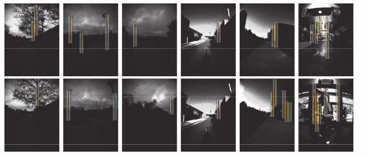
Active self-localization task consists of four distinctive
stages: planning, action, detection, and matching (Fig. 2).
The planning stage determines the NBV action, given a
history of live images and states, using an NBV planner
that is trained in a past domain. The action stage exe-
cutes the planned NBV action. The detection stage aims
to detect domain-invariant landmark objects using the pre-
trained detector. The matching stage aims to query a pre-
built database of landmark views associated with ground-
truth GPS viewpoints to infer the robot pose, and this stage
is performed only when one or more landmark objects are
detected. The inference result and all the inference history
from previous iterations are integrated to obtain an estimate
of the robot pose and its confidence score. The above four
stages are iterated until the confidence score exceeds a pre-
set threshold.
III. A PPROACH
Fig. 2. Active self-localization task.
This section presents the proposed framework for active
visual self-localization (Fig. 3). The domain-invariant pole-
like landmark detection network (PLD), as well as the
retraining (i.e., maintenance-free). The domain-invariance domain-adaptive action policy determination block (APD),
can be considered as a novel advantage of the proposed are emphasized. On the other hand, spatial landmark ag-
approach to existing NBV planners. Intuitively, a domain- gregation module (SLA) can reduce the dimension of PLD
invariant NBV planner could restrict itself to take domain- output and computational complexity of the DRL -based
invariant visual features as the sole input. In addition, it could learner/planner. On the other hand, through fusing invariant
learn domain-invariant statistics of landmark configuration, pole-like landmarks and discriminative holistic edge images,
such as average travel distance between pole-like landmark the passive self-localization block (PSL) can make use of
views. Moreover, it could arrange the plan depending on the information from PLD. One the other hand, the expe-
whether the current live image is a landmark view or not. rience replay (ER) module provides random access to past
However, training a domain-invariant landmark detector as experiences. As a result, these modules or components with
well as an NBV planner, with reasonable computational cost, each other boost the performance of active self-localization
from an available visual experience, is a non-trivial problem system.
and which is the focus of our study.
We tackle this problem by introducing a deep convolu- A. NBV Planner
tional neural network (DCN) -based landmark detector and We use deep Q-learning network (DQN) as the basis
a deep reinforcement learning (DRL) -based NBV planner. for our NBV planner. In our view, the model-free property
Our DCN module is built on a recently developed multi- of Q-learning is desirable for the robotic self-localization
scale multi-encoder deep convolutional neural network [8]. applications, as it does not include model parameters to
Our formulation of DRL is related to recent works on deep be learned and it can intelligently avoid the possibility of
reinforcement learning -based NBV planner [9]. However, learning a wrong model. However, classical Q-learning fails
rather than using typical sensor inputs such as raw images, for large-scale problems due to “curse of dimensionality”.
we propose to use domain-invariant perceptual information, The recent paradigm of DQN addresses this issue by ap-
which is made available by the proposed landmark detector, proximating the value-action function with a deep neural
to make our NBV planner a domain-adaptive one. network. Our approach extends this technique in two ways.
Our main contributions are summarized as follows: (1) First, a part of the deep neural network is replaced with
This work is the first to address the issue of domain- a multi-scale multi-encoder DCN block, derived from the
invariant NBV using invariant pole-like landmarks. (2) Our state-of-the-art HED network [8], which is very different and
landmark detection network is built on the recent paradigm significantly more complex than existing deep neural network
in image edge detection, deep holistic edge detection (HED), employed by typical DQN approaches. Second, the landmark
which can detect a small number of holistic essential scene detector is pretrained on Big data before being introduced as
structure, rather than conventional detectors such as Canny a component of the NBV planner.
[10] that tend to detect lots of complex primitive edges. (3)
The effectiveness of the planning algorithm in terms of self- B. Pole-like Landmark Detection (PLD)
localization performance and domain-invariance is verified Our PLD network architecture is inspired by the recent
via experiments using publicly available NCLT dataset. paradigm in the field of holistic edge detection (HED) [8].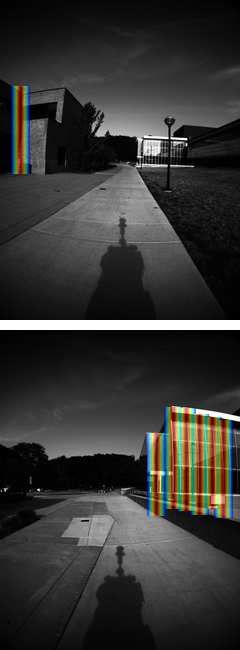
landmark feature map. The aggregation network summarizes
                                                                the likelihood of pole-like landmark in each different hor-
                                                                izontal range in the input image, respectively [0,W /4 − 1],
                                                                [W /4,W /2 − 1], [W /2, 3W /4 − 1], and [3W /4,W ], where W
                                                                is the original image width. Then, the 4-dim vector is passed
                                                                to the activation network. The activation network is trained
                                                                only once, in a specific past domain. This 4-dim vector is
                                                                input to the value-action function block, which is described
                                                                above. While the locations of pole endpoints in the single
                                                                train domain are manually annotated in the current study,
                                                                unsupervised annotation by introducing techniques like pole-
                                                                based SLAM [6] would be an interesting direction of future
                                                                research.

                                                                C. Implementation Details
                                                                   We adopt the spatial bag-of-words (BoW) image model
                   Fig. 3.   System architecture.               for our PSL module. A BoW model represents every
                                                                query/mapped image with a collection of vector quantized
                                                                local visual features, called visual words [11], which are then
In particular, we are based on the multi-scale multi-encoder    efficiently indexed/retrieved using an inverted file system.
HED network that consists of multiple encoder blocks that       The spatial BoW (SBoW) is an extension of the BoW image
act as multi-scale encoder blocks. These main blocks consist    model to include spatial information of visual words [12].
of 3×3 convolutional sub-blocks that are densely intercon-      We observe that the SBoW is applicable to our case by
nected by the output of the previous main block, and the        using the horizontal location of pole-like landmark (xo , yo ) as
outputs of each sub-block are connected between them via        the domain-invariant reference for spatial information. More
a 1×1 convolutional block. The pseudo code of the PLD           specifically, we compute the spatial information of a given
network y = f (x) is as follows:                                visual feature’s location (x, y) as (x′ , y′ ) = (x − xo , y) (Fig.
                                                                1c).
y1 = DoubleConv(x); s1 = SingleConv(x);
                                                                   A bottleneck of the SBoW is the computation cost to
y2 = DoubleConv(y1); d2 = MaxPool(y2); x2 =
                                                                simulate the SPL tasks. That is, the cost for querying the
d2 + s1 ; s2 = SingleConv(x2);
                                                                SPL image database for each visual image in each query, is
p3 = SingleConv(d2); y3 = DenseBlock(x2 , p3 ); d3 =
                                                                in the order of O(Nimages Nwords ) where Nimages is the number
MaxPool(y3); x3 = d3 + s2 ; s3 = SingleConv(x3);
                                                                of visual images per experience and Nwords is the number of
p24 = P2 (d2 ); p4 = P4 (p24 + D3 ); y4 =
                                                                visual words per image. To reduce the cost, it is essential to
DenseBlock(x3 , p4 ); d4 = MaxPool(y4); x4 =
                                                                represent the visual experience in a time/spatial efficient and
d4 + s3 ; s4 = SingleConv(x4);
                                                                random accessible manner. To address this, we summarize
p25 = SingleConv(p24); p5 = SingleConv(b25 + d4); y5 =
                                                                all the possible PSL tasks in a lookup table, which is then
DenseBlock(x4 , p5 ); x5 = y5 + s4 ;
                                                                used to simulate the experience replay in an efficient manner.
p6 = SingleConv(y5); y6 = DenseBlock(x5 , p6 );
                                                                Given a pairing of query and map image sets, the lookup
y7 = Concat(x×1, y1 ×1, y2 ×2, y3 ×4, y4 ×8, y5 ×16, y6 ×16);
                                                                table is constructed in the following procedure. First, the
x7 = SingleConv(y7); y7 = Aggregate(x7);
                                                                SBoW-based information retrieval system is queried for each
x8 = Activate(y7); y8 = VectorQuantize(y);
                                                                query image, and top-K retrieval results are obtained. Then,
The operations ’×’ and ’+’ are the upsampling and addition.     the similarity between the query image and each of the top-K
DenseBlock, DoubleConv and SingleConv are the dense             similar map images is computed. Then, the similarity value
block, double and single convolutional blocks. MaxPool,         is compactly represented in a short B-bit distance value. The
Concat are respectively, the max pooling, and concate-          parameters K and B are empirically set K = 1000 and B = 8
nate operations. Our implementation basically follows the       considering the accuracy-compactness tradeoff.
state-of-the-art HED framework in [8]. However, the HED            The deep Q-learning network is trained in the experience
framework is modified to deal with our DQN task. That           replay procedure. An experience is defined as a history
is, the 2D edge feature map output by the HED part is           of planned actions, acquired live images, and states. The
spatially aggregated to produce a horizontal 1D image that      NBV action a for the current state s is selected with the
represents the likelihood of pole-like landmarks (Aggregate).   probability in proportional to the function exp(Qa,s ). Our
Then, the spatially-aggregated 1D image is further input        scheme could be replaced with more advanced experience
to the SLA block that consists of a pre-trained activation      replay frameworks, such as prioritized experience replay [13]
network (Activate) followed by a vector quantization blocks     or dueling network [14], which would be a future direction
(VectorQuantize) to produce an extremely compact 4-dim          of our research.
A navigation task is terminated if the score distribution heuristics. Intuitively, long distance move is useful to search
becomes a sufficiently narrow distribution. More formally, it for out-of-view landmark objects, while short distance move
is judged if the score of the highest scored location exceeds is useful to approach to landmark objects in the field of
that of the second scored location with a large margin (0.1). view to obtain a closer view of them. Based on the idea,
the heuristics selects long distance move Clong + ∆d if there
IV. E XPERIEMENTS is no detected landmark in the live image, or short distance
We evaluated the effectiveness of the proposed algorithm move Cshort + ∆d otherwise, where ∆d is an artificial motion
via active cross-domain self-localization in different do- noise in range [−1, 1] [m]. Clong and Cshort are two different
mains. We used the publicly available NCLT dataset [15]. constant parameters that are learned in the training domain.
The NCLT dataset is a large-scale, long-term autonomy To learn the constants Cshort and Clong , the training image
dataset for robotics research collected at the University of dataset is split into two disjoint subsets, i.e., images with
Michigan’s North Campus by a Segway vehicle robotic plat- and without pole-like landmark views, and then Cshort and
form. The data we used in the research includes view image Clong , is optimized to maximize for individual subsets the
sequences along vehicle’s trajectories acquired by the front possibility of positive landmark detection. The next three
facing camera of the Ladybug3 as well as the ground-truth methods, “Constant (w/ view)”, “Constant (w/o view)”, and
GPS viewpoint information. It involves both indoor and out- “Constant (all)” determine the robot step size, respectively,
door change objects such as cars, pedestrians, construction as Cshort ± 1, Clong ± 1, and Call ± 1, regardless of whether the
machines, posters, and furniture, during seamless indoor and live image is pole-like landmark view or not. Call is learned
outdoor navigations of the Segway robot. In our experiments, in the training domain, in a similar procedure as in Cshort
three different pairings of training and test datasets are used: and Clong , but by using all the training images instead of
(2012/1/22, 2012/3/31), (2012/3/31, 2012/8/4), (2012/8/4, the subsets. Cost versus performance for the four pairings
2012/11/17). The four datasets “2012/1/22”, “2012/3/31”, of training and test seasons are shown in Fig. 5. It is clear
“2012/8/4”, and “2012/11/17” consist of 26208, 26364, that the proposed approach significantly outperforms all the
24138, and 26923 images. Images are resized to 320×240. approaches considered here. It could be concluded that a
Figures 1 and 4 show examples of pole-like landmark non-trivial good policy was learned with a model-free DQN
detection. As shown, the proposed detector successfully de- from only domain-invariant landmarks and HED images.
tected pole-like landmarks, such as poles, as well as vertical
V. C ONCLUSIONS
edges of building, walls, and doors. On the other hand, it can
intelligently avoided false positive detection of non-structural In this paper, a novel framework of cross-domain active
non-dominant edges, such as tiles on the roads and leafs on self-localization using pole-like landmarks was proposed.
the trees. Unlike previous approaches to active self-localization, we
Figure 4 shows examples of views before and after planned hypothesize that pole-like landmarks are inherently invariant,
NBV actions. Intuitively convincing behaviour of the robot stable and ubiquitous cue for visual robot self-localization.
was observed. When a pole-like landmark is near from the Based on the idea, a novel multi-scale multi-encoder land-
robot viewpoint, the robot tends to plan to move a short mark detection network is introduced to enable detection
distance so as to avoid lose track of the already observed of holistic essential landmarks, which are then used as the
landmarks. Otherwise, the robot tends to plan to move a sole input to an off-policy model-free DQN-based NBV
long distance so as to detect unseen landmarks or approach planner. The result is a domain-invariant variant of NBV
to already seen landmarks. Such behaviors are intuitively planner that attains consistent performance over different
appropriate and effective to seek and track landmarks when domains, without requiring the expensive task of training
one got lost. It is noteworthy that our approach enables to data collection and retraining. The effectiveness of the plan-
learn such appropriate step sizes from the available visual ning algorithm in terms of self-localization performance
experience. and domain-invariance was experimentally verified using
Figure 5 shows cost vs. accuracy results for quantitative publicly available NCLT dataset.
evaluation. The cost is measured in terms of the number of R EFERENCES
iterations to reach the termination condition of the active self-
[1] H. Hu, H. Wang, Z. Liu, C. Yang, W. Chen, and L. Xie, “Retrieval-
localization task, i.e., the confidence score exceeds the pre- based localization based on domain-invariant feature learning under
set threshold, which is a function of the number of positive changing environments,” in IEEE/RSJ Int. Conf. Intelligent Robots and
detections of pole-like landmark views. The accuracy is Systems (IROS), 2019, pp. 3684–3689.
[2] R. Arandjelović, P. Gronat, A. Torii, T. Pajdla, and J. Sivic,
measured in terms of the rank assigned to the ground- “NetVLAD: CNN architecture for weakly supervised place recogni-
truth robot pose when the active self-localization task is tion,” in IEEE Conference on Computer Vision and Pattern Recogni-
terminated. tion, 2016.
[3] N. Merrill and G. Huang, “CALC2.0: Combining appearance, semantic
Our proposed method (“Learned”) is compared against six and geometric information for robust and efficient visual loop closure,”
different methods: “Heuristics”, “Constant (w/ view)”, “Con- in IEEE/RSJ Int. Conf. Intelligent Robots and Systems (IROS), Macau,
stant (w/o view)”, “Constant (all)”, and “Oracle”. “Heuris- China, Nov. 2019.
[4] M. Drumheller, “Mobile robot localization using sonar,” IEEE transac-
tics” is a manually designed strategy that selects either tions on pattern analysis and machine intelligence, no. 2, pp. 325–332,
of short or long distance move, based on a pre-designed 1987.Fig. 4. NBV planning results. In each figure, the top and bottom panels show the view image before and after the planned movements, respectively.
40
Learned
Heuristics
[13] T. Schaul, J. Quan, I. Antonoglou, and D. Silver, “Prioritized experi-
Constant (w/ view)
Constant (w/o view)
ence replay,” arXiv preprint arXiv:1511.05952, 2015.
35 Constant (all)
Random
[14] Z. Wang, T. Schaul, M. Hessel, H. Hasselt, M. Lanctot, and N. Freitas,
Oracle “Dueling network architectures for deep reinforcement learning,” in
30 International conference on machine learning, 2016, pp. 1995–2003.
[15] N. Carlevaris-Bianco, A. K. Ushani, and R. M. Eustice, “University
25 of michigan north campus long-term vision and lidar dataset,” The
avg. move
International Journal of Robotics Research, vol. 35, no. 9, pp. 1023–
20
1035, 2016.
15
10
5
1 10 100 1000 10000 100000
rank
Fig. 5. Cost vs. performance. Vertical axis (cost): travel distance between
the initial and final viewpoints. Horizontal axis (performance): ground-truth
ranking of the final estimate.
[5] M. A. Brubaker, A. Geiger, and R. Urtasun, “Lost! leveraging the
crowd for probabilistic visual self-localization,” in Proceedings of the
IEEE Conference on Computer Vision and Pattern Recognition, 2013,
pp. 3057–3064.
[6] R. Spangenberg, D. Goehring, and R. Rojas, “Pole-based localization
for autonomous vehicles in urban scenarios,” in 2016 IEEE/RSJ
International Conference on Intelligent Robots and Systems (IROS).
IEEE, 2016, pp. 2161–2166.
[7] R. Pito, “A solution to the next best view problem for automated sur-
face acquisition,” IEEE Transactions on pattern analysis and machine
intelligence, vol. 21, no. 10, pp. 1016–1030, 1999.
[8] X. Soria, E. Riba, and A. Sappa, “Dense extreme inception network:
Towards a robust cnn model for edge detection,” in The IEEE Winter
Conference on Applications of Computer Vision (WACV ’20), 2020.
[9] A. Roberti, M. Carletti, F. Setti, U. Castellani, P. Fiorini, and
M. Cristani, “Recognition self-awareness for active object recognition
on depth images.” in BMVC, 2018, p. 15.
[10] J. Canny, “A computational approach to edge detection,” IEEE Trans-
actions on pattern analysis and machine intelligence, no. 6, pp. 679–
698, 1986.
[11] J. Sivic and A. Zisserman, “Video google: A text retrieval approach
to object matching in videos,” in null, 2003, p. 1470.
[12] Y. Cao, C. Wang, Z. Li, L. Zhang, and L. Zhang, “Spatial-bag-of-
features,” in 2010 IEEE Computer Society Conference on Computer
Vision and Pattern Recognition. IEEE, 2010, pp. 3352–3359.You can also read