DRAFT TIDAL WETLANDS GUIDELINES - Submitted to Virginia Coastal Zone Management Program August 2008
←
→
Page content transcription
If your browser does not render page correctly, please read the page content below
DRAFT

  TIDAL
WETLANDS
GUIDELINES

    Submitted to
Virginia Coastal Zone
Management Program

    August 2008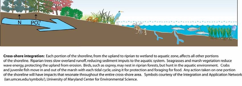
This project was funded by Virginia Coastal Zone Management Program at the Department of
Environmental Quality through Grant #NAO5NOS4191180 of the U.S. Department of
Commerce, National Oceanic and Atmospheric Administration, under the Coastal Zone
Management Act of 1972, as amended.
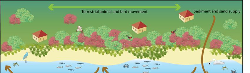
Table of Contents
Section 1: Introduction ................................................................................................................. 4

Section 2: Definitions .................................................................................................................. 6

Section 3: Tidal Wetlands in the Ecosystem ................................................................................ 7
Wetland Services to Shoreline Ecosystems.................................................................................. 8

Section 4: Tidal Wetlands Classification ................................................................................... 11
General Distribution ................................................................................................................... 11
Tidal Wetland Classes ................................................................................................................ 15
Vegetated.................................................................................................................................... 15
  Salt/ Brackish emergent low marsh........................................................................................ 15
     Subclass: Smooth Cordgrass .............................................................................................. 15
     Subclass: Mixed.................................................................................................................. 15
  Brackish emergent high marsh ............................................................................................... 15
  Scrub/shrub............................................................................................................................. 16
  Tidal Fresh emergent .............................................................................................................. 16
  Tidal Forested......................................................................................................................... 17
     Subclass: Bald Cypress....................................................................................................... 17
     Subclass: Mixed Hardwood................................................................................................ 17
Nonvegetated.............................................................................................................................. 18
  Sandy Intertidal ...................................................................................................................... 18
  Other Non-vegetated Intertidal............................................................................................... 18
  Shell-Rock-Rubble ................................................................................................................. 18

Section 5: Criteria for project review ......................................................................................... 19
  General Criteria ...................................................................................................................... 19
  Required Information ............................................................................................................. 19
  Time of Year Restrictions ...................................................................................................... 21
  Specific Criteria...................................................................................................................... 22
     1. Shoreline Protection ....................................................................................................... 22
     2. Dredging ......................................................................................................................... 24
     3. Channeling into Uplands and Marshes........................................................................... 25
     4. Stormwater Facilities and Best Management Practices (BMPs).................................... 25
     5. Marinas ........................................................................................................................... 25
     6. Drainage and Mosquito Ditching ................................................................................... 25
     7. Utility Crossings............................................................................................................. 26
     8. Aquaculture .................................................................................................................... 26
     9. Temporary Impacts......................................................................................................... 26
     10. Flooding and Sea Level Rise........................................................................................ 27

Section 6: Glossary..................................................................................................................... 28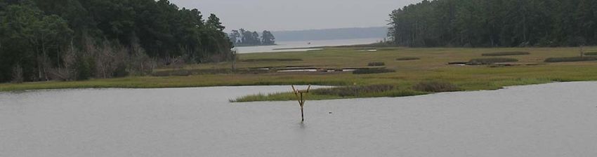
Section 1: Introduction
The purpose of this document is to update the Tidal Wetlands Guidelines. Originally adopted
by the Marine Resources Commission in 1974, the guidelines were formally amended to
include non-vegetated wetlands in 1982. The Wetlands Mitigation-Compensation Policy first
adopted in 1989 was added to the Guidelines when they were reprinted in 1993. The most
recent change to tidal wetlands guidance was an update to the Mitigation-Compensation Policy
in 2005. These later amendments were critical changes to the Guidelines that focused on the
addition of new information and policy while the original content and construct of the
guidelines remained largely unchanged.

The scientific understanding of the role of tidal wetlands and the connection between wetlands
and riparian lands and subaqueous lands has continued to evolve and improve. This
understanding requires resource management decisions that are based upon a systems-based
perspective rather than an individual resource. The guidelines should reflect the current
understanding of tidal wetlands to promote informed decision-making regarding this important
resource.

There are close to 300,000 acres of tidal wetlands in Virginia found along shores of the
Chesapeake Bay and it’s tributaries, as well as Back Bay, and the coastal bays and inlets of the
Atlantic Coast. The greater share of these is found in the broad, expansive marshes on the
seaside of the Eastern Shore and the remaining wetlands line the shores of Virginia’s creeks
and rivers. These same shores have and continue to provide access to commerce and trade and
are an increasingly popular choice for residential living. Years of human impact have resulted
in wetland losses and adverse impacts on wetland functions that have diminished the resource
and adversely affected the role of wetlands in the ecosystem.

The Commonwealth of Virginia has committed to a policy of no-net-loss of wetlands, tidal and
nontidal. For tidal wetlands, the Wetlands Mitigation-Compensation Policy provides criteria
for mitigation and compensation for all direct permitted tidal wetlands losses.

However, wetlands are also adversely impacted indirectly by actions taken along the shoreline.
Certain erosion control structures may exacerbate erosion of channelward and adjacent
wetlands by transferring energy along the shoreline. The placement of a hardened structure in,
or landward of the tidal wetlands, means that the wetlands will convert to open water with
rising sea level.

The placement of an erosion control or other structure has a local and regional effect on the
distribution of sand and sediment. Erosion control structures do act to stabilize eroding
shorelines and prevent sediment from entering the water. At the same time, the sediment
trapped behind structures and removed by other actions reduces the amount of available
sediment. Tidal vegetated marshes need to trap sediment to adjust to rising sea levels. Sandy
material from eroding shorelines maintains and builds beaches providing erosion protection and
waterfront access. This contributes to the loss of wetlands through erosion and sea level rise.
Cumulative wetlands losses, modifications of riparian buffers and impacts to submerged
aquatic vegetation (SAV) and subaqueous lands are linked to the degradation of the ecosystem.
Loss of water quality and adverse effects on the habitats for finfish, crustaceans, shellfish,
waterfowl and wading birds is the result. The direct effects of losses of any of these resources
are compounded when added together. Decisions made regarding wetlands should be
integrated with consideration of associated resources to provide the most comprehensive
approach to resource management.

In addition to impacts due to human activities, some wetlands loss is also a natural occurrence,
as rising sea level proceeds faster than marshes are able to move upward or landward. Tidal
marshes are subject to loss from erosion as well.

The sustainability of tidal wetlands will depend not just upon avoidance and appropriate
compensation for direct losses, but broader, longer-term consideration of the health of the
resource. The persistence of these critical ecosystems will require sound planning and
management to accommodate the natural losses with landscape level actions while addressing
the man-made impacts through the application of preferred alternatives to shoreline
management.

The guidelines included in this document are intended to promote the preservation of tidal
wetland while accommodating necessary economic development in a manner consistent with
the best scientific and technical information considering the relationship of riparian lands,
wetlands and adjacent submerged lands.
Section 2: Definitions
         Tidal Wetlands: Vegetated
"Vegetated wetlands" means lands lying between and contiguous to mean low water and an
elevation above mean low water equal to the factor one and one-half times the mean tide range
at the site of the proposed project in the county, city, or town in question, and upon which is
growing any of the following species: saltmarsh cordgrass (Spartina alterniflora), saltmeadow
hay (Spartina patens), saltgrass (Distichlis spicata), black needlerush (Juncus roemerianus),
saltwort (Salicornia spp.), sea lavender (Limonium spp.), marsh elder (Iva frutescens),
groundsel bush (Baccharis halimifolia), wax myrtle (Myrica sp.), sea oxeye (Borrichia
frutescens), arrow arum (Peltandra virginica), pickerelweed (Pontederia cordata), big cordgrass
(Spartina cynosuroides), rice cutgrass (Leersia oryzoides), wildrice (Zizania aquatica), bulrush
(Scirpus validus), spikerush (Eleocharis sp.), sea rocket (Cakile edentula), southern wildrice
(Zizaniopsis miliacea), cattail (Typha spp.), three-square (Scirpus spp.), buttonbush
(Cephalanthus occidentalis), bald cypress (Taxodium distichum), black gum (Nyssa sylvatica),
tupelo (Nyssa aquatica), dock (Rumex spp.), yellow pond lily (Nuphar sp.), marsh fleabane
(Pluchea purpurascens), royal fern (Osmunda regalis), marsh hibiscus (Hibiscus moscheutos),
beggar's tick (Bidens sp.), smartweed (Polygonum sp.), arrowhead (Sagittaria spp.), sweet flag
(Acorus calamus), water hemp (Amaranthus cannabinus), reed grass (Phragmites communis),
or switch grass (Panicum virgatum). Code of Virginia §28.2-1300

        Tidal Wetlands: Nonvegetated
"Nonvegetated wetlands" means unvegetated lands lying contiguous to mean low water and
between mean low water and mean high water, including those unvegetated areas of Back Bay
and its tributaries and the North Landing River and its tributaries subject to flooding by normal
and wind tides but not hurricane or tropical storm tides. Code of Virginia §28.2-1300.

        Water Dependent
As defined by the Virginia Marine Resources Commission, water dependent means "those
structures and activities that must be located in, on, or over tidal wetlands." When applying
this definition, both of the following questions must be answered affirmatively:

1. Is it necessary that the structure be located over wetlands? and,
2. Is it necessary that the activity associated with the structure be over the wetlands?
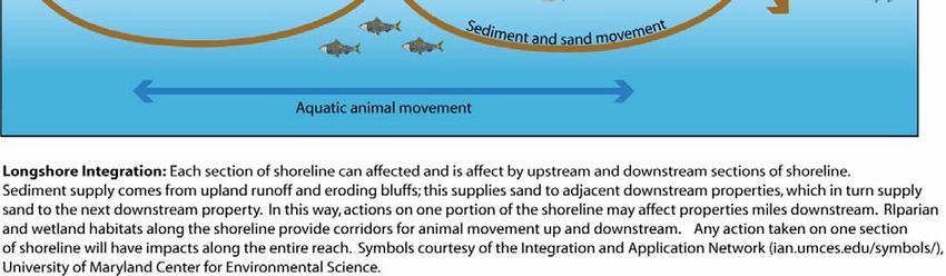
Section 3: Tidal Wetlands in the Ecosystem

Tidal wetlands are one component of the tidal shoreline ecosystem. Tidal wetlands, upland and
riparian lands, nearshore waters, and in some cases beaches and dunes make up the tidal
shoreline system.

Tidal shorelines are the site of complex interactions between terrestrial and aquatic systems
(Figure 1). These areas have values that far outweigh their relative size in the larger ecosystem.
The interactions and functions of shorelines occur both across and along the shore. Interactions
along the shore can occur at site-specific, creek, river and larger scales (Figure 2). Larger scales
may be defined as a reach, a discrete portion of a shoreline somewhat homogeneous in its
physical characteristics and upon which there are mutual interaction of the forces of erosion,
sediment transport, and accretion.

The tidal shoreline system is exceptionally important habitat for a wide variety of organisms,
some living primarily on land, others that live in water, and a few that are found only in the
intertidal zone between land and water. They provide important filtration capacity for materials
carried in runoff and groundwater. Shorelines often have natural erosion resilience in the form
of wetlands, beaches and dunes and nearshore flats. The ecological functions that are valued
by humans are referred to as ecosystem services.

Shorelines are transient ecosystems. Physically they are the transition between uplands and
water. Temporally, they respond to climate, geologic, biologic and chemical processes. There
are two certainties of shorelines; 1) shorelines change, and 2) humans seek to manage
shorelines.

On tidal shorelines, each component is managed independently as required by separate laws.
Local governments implement the Tidal Wetlands Act and Coastal Primary Sand Dune Act
through Wetland Boards and the Chesapeake Bay Preservation Act through a Bay Board or
other process, while subaqueous lands are the responsibility of the Virginia Marine Resources
Commission. Each program seeks to avoid impacts in areas under their jurisdiction. This may
mean that decisions made regarding the actions in wetlands can have adverse impacts on
riparian and submerged lands, and visa versa. And that the environmental preferred action may
necessitate work in, or impacts to, multiple resources to achieve a beneficial outcome.

Guidance that is based upon an integration of shoreline concepts creates the opportunity to
maximize the ecological benefits derived from the various resources. Recognition that
particular shoreline management options may not be uniformly desirable from different
regulatory perspectives means coordination among management agencies will be essential.
The basis for coordination is the rationale for establishment of the various regulatory programs
– sustaining public benefits from environmental services. The desire to maintain the capacity
of the natural system to do the things that are important and valuable to the general citizenry of
the Commonwealth underpins the riparian, intertidal and subaqueous lands management
programs operating in Virginia. These programs uniformly seek to accommodate private and
public development interests within the broader goal of sustaining ecosystem services.
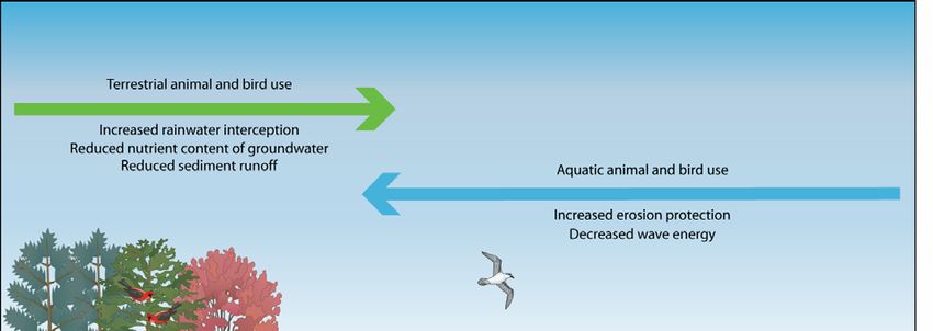
Wetland Services to Shoreline Ecosystems
The relationship between shoreline resources and ecosystem functions is very complex. Tidal
wetlands are unique systems that bridge the gap between uplands and tidal waters. Some
wetland functions such as the provision of intertidal habitats are specific to this condition.
While other functions, such as the production of vegetative material to support estuarine
foodwebs, are provided to varying degrees by other components of the shoreline system like
SAV and forested riparian buffers. And still other functions are dependent upon the
interactions of tidal wetlands with other components of the shoreline system.

Tidal Wetlands provide the following ecosystem services:
           • Habitat (food and shelter) for both aquatic and terrestrial animals such as blue
              crabs, small fish and marsh birds.
           • High productivity and the contribution to aquatic food webs through the growth
              of algae and the export of detritus.
           • Filtration of tidal waters, overland flow, and groundwater.
           • Sediment stabilization. Aboveground, plants trap sediment and help to
              attenuate wave action. Belowground, plant roots stabilize sediments.
              Nonvegetated wetlands provide a buffer between uplands and the waterway.
           • Aesthetics, open space, recreation.

         SHORELINE                         ECOSYSTEM                           VALUES
        ECOSYSTEMS                          SERVICES                        Foods Production
             Marsh                         Water Quality                   Species Preservation
             Forest                           Habitat                            Fishing
        Submerged Lands                      Sediment                          Recreation
         Anthropogenic                      Stabilization                     Flood Control
           Structures                                                        Erosion Buffer

   Figure 1. Ecosystem Services Flow Diagram.
   Each element of the ecosystem provides one, or more, functions. These functions provide
   one, or more, values to society.
Figure 2. Cross-shore Ecosystem Services
Figure 3. Longshore Ecosystem Services
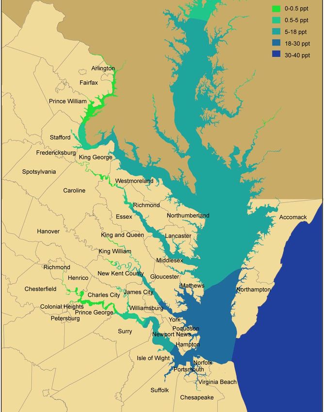
Section 4: Tidal Wetlands Classification
This classification reflects the Virginia definition of tidal wetlands with types, or classes, of
both vegetated and non-vegetated wetlands.

The vegetated wetland classes are described by the dominant plant, or plants with supporting
information provided by Fleming et al (2006). Vegetative community composition depends
mostly upon tidal inundation and salinity. The non-vegetated wetlands are described by the
dominant substrate, which depends on sediment distribution, relative wave energy and
sediment transport, plus anthropogenic actions.

The classification system is designed to reflect the provision of ecosystem services of water
quality, habitat and sediment stabilization. The provision of these services is influenced by the
dominant structure, whether vegetation or substrate. As a result, the classification system that
is largely based upon wetland structure is also indicative of ecosystem services.

General Distribution
Tidal wetlands are found along Virginia’s shorelines of the Chesapeake Bay, its’ tributary
rivers and creeks and the coastal bays on the Atlantic Seaside.

Waterlogged soils and salinity are the primary physical factors that determine the distribution
of tidal wetlands vegetation. Water and salinity both create stressful conditions for plant
survival. In general, for marsh plants, the vegetation in lower intertidal areas is set by physical
factors such as tidal inundation and salinity, whereas the vegetation in high intertidal areas is
set by competition. The terms “high” and “low” marsh refer to the relative elevation within
the intertidal zone. Low marsh areas are tidal communities that are flooded semi-diurnally, or
twice daily. High tidal marsh communities are irregularly flooded, lunar tidal and wind-tidal
wetlands.

Tidal range varies along Virginia’s rivers and creeks from about 1 foot in the Rappahannock
near Fredericksburg, to 4 feet on the upper Mattaponi. The variable tide range is a critical
consideration as the upper edge of vegetated wetland jurisdiction defined as an elevation 1.5
times the tide range. Extensive survey and vegetative community studies support the use of
indicator species to identify the upper limit of vegetated wetlands. There are instances,
however, where salt spray or groundwater discharge supports the occurrence of common
wetland plants above the defined elevation.

In the Bay, salinity decreases traveling from the Atlantic Ocean, at 32 ‰, upstream to a point
where salinity is absent and freshwater inputs dominate (Figure 4). The general distribution of
tidal wetlands from brackish to fresh follows the salinity distribution. Plant species
composition shifts along estuarine salinity gradients, with salt-tolerant halophytic plants
dominating salt and brackish marshes and non-halophytic wetland plants dominating tidal
freshwater habitats (Odum and Hoover 1988, Mitsch and Gosselink 2000). The diversity of
plant species increases with decreasing salinity. Figure 5 identifies the plant species listed in
the tidal Wetland Act by relative salinity as shown in Figure 4.
By and large, localities on the Eastern Shore, with bay frontage, and on the lower reaches of the
James, York, Rappahannock and Potomac have brackish wetlands. However, each tributary
river and creek acts as a miniature estuary with decreasing salinity moving upstream. This
means that freshwater marshes can be found in localities where brackish marshes are most
common.
Figure 4. General Salinity Distribution in Virginia
Figure. 5. Tidal Wetland Plants
Tidal Wetland Classes
       Salt/ Brackish emergent low marsh
               Smooth Cordgrass
               Mixed
       Brackish emergent high marsh
       Scrub/shrub
       Tidal Fresh emergent
       Tidal Forested
               Bald Cypress
               Mixed Hardwood
       Sandy Intertidal
       Other Non-vegetated Intertidal
       Shell-Rock-Rubble

       Vegetated

Salt/ Brackish emergent low marsh
        Subclass: Smooth Cordgrass
        This community is associated with high salinity conditions along the shorelines of the
Bay, lower reaches of the tributary rivers and the Atlantic coastal Bays. It occurs generally as
monotypic stands of Spartina alterniflora, Smooth cordgrass. Smooth cordgrass grows
between the elevation of mid-tide and mean high water. Few emergent plants are associated
with this community. Black needlerush (Juncus roemerianus) may be found occasionally.

        Subclass: Mixed
        With decreasing salinity, the vegetative community becomes a mix of smooth cordgrass
and other species. Black needlerush (Juncus roemerianus) and saltmarsh bulrush
(Schoenoplectus robustus formerly Scirpus robustus) are found in the intertidal area as both can
tolerate salinity and the twice daily flooding. Other plants that occupy the intertidal zone but
have lower salinity tolerance include chairmaker’s rush (Schoenoplectus americanus), and
softstem bulrush (Schoenoplectus tabernaemontani). Just downstream from tidal freshwater, in
low salinity wetlands the other species may be the dominant vegetation.

Brackish emergent high marsh
These marshes are found in the Atlantic coastal bays and along the bay and it’s tributaries.
Tidal brackish high marshes are typically characterized by low diversity and dominated by
grasses. The vegetation often forms a mosaic rather than a distinct zone. A common name for
these marshes is salt meadows. The dominant grasses are saltmeadow hay, Spartina patens and
saltgrass, Distichlis spicata. There are several other plant species commonly associated with
high marshes. These include sea-oxeye (Borrichia frutescens), sea-lavender (Limonium
carolinianum), saltmarsh fleabane (Pluchea odorata), saltmarsh bulrush (Schoenoplectus
robustus formerly Scirpus robustus), Schoenoplectus tabernaemontani (formerly Scirpus
validus), sea rose-pink (Sabatia stellaris) and marsh aster (Aster tenuifolius). Salt marsh panes,
with higher than average salinities, are often associated with glassworts (Salicornia virginica
and Salicornia bigelovii) and black needlerush (Juncus roemerianus).
Big cordgrass, Spartina cynosuroides, may be found along the landward edges of higher
salinity marshes and as a dominant species in lower salinity areas. Other species common in
these areas include smartweed (Polygonum punctatum) and halberd-leaved tearthumb
(Polygonum arifolium), bull-tongue arrowhead (Sagittaria lancifolia), eastern rose-mallow
(Hibiscus moscheutos), seashore mallow (Kosteletzkya virginica), and swamp dock (Rumex
verticillatus). Common along the upland edge of the high marsh where ground water inputs
and nutrients are high is the narrow-leaved cattail (Typha angustifolia). Switchgrass (Panicum
virgatum) and seaside goldenrod (Solidago sempervirens) are also found along the upper limit
of the brackish emergent high marsh.
The upland-wetland boundary, dredge disposal areas and other disturbed areas often support
dense, nearly monospecific colonies of common reed (Phragmites australis). Phragmites is an
aggressive species that can out compete other native species in tidal and nontidal wetlands.
Scrub/shrub
These wetlands comprise the ecotone between high marsh, tidal fresh emergent and swamp
forests or uplands. Most of the tidal scrub/shrub wetlands are dominated by two species of
saltbushes; groundsel tree, Baccharis halimifolia and marsh elder, Iva frutescens. Switchgrass
(Panicum virgatum) and seaside goldenrod (Solidago sempervirens are commonly associated
with saltbushes. On the landward side of the saltbushes and in lower salinity scrub/shrub
marshes, bayberries (Morella cerifera, formerly Myrica cerifera) are common. Further upriver
the scrub/shrub community may include species characteristic of both tidal fresh emergent
marshes and tidal forests such as smooth alder (Alnus serrulata), buttonbush (Cephalanthus
occidentalis), swamp rose (Rosa palustris), black willow (Salix nigra), and silky dogwood
(Cornus amomum). In the upper reaches of the tidal rivers, this community is largely replaced
by tidal forest.
Tidal Fresh emergent
Community Composition
These wetlands are found along the upper tidal reaches of rivers and tributaries throughout the
coastal plain. The plants in this community are generally intolerant of salinity. While notable
examples are found in the great expanses of tidal fresh marshes along the Pamunkey and
Mattaponi Rivers, these marshes also occur as fringe marshes along the water-upland boundary.
Tidal freshwater species may also be found along the upper edge of brackish wetlands where
freshwater inputs from groundwater, or runoff, provide appropriate growing conditions. Some
species in this community also occur in nontidal wetlands.
The vegetation of these marshes tends to be fairly diverse and patchy in distribution. Those
marshes that are higher in elevation and are upstream of any salinity are the most diverse. The
most common species are arrow-arum (Peltandra virginica), pickerelweed (Pontederia
cordata), dotted smartweed (Polygonum punctatum var. punctatum), wild rice (Zizania
aquatica var. aquatica), rice cutgrass (Leersia oryzoides), tearthumbs (Polygonum arifoliumand Polygonum sagittatum), beggar-ticks (Bidens spp.), and annual wild rice (Zizania
aquatica). In places, sweetflag (Acorus calamus), waterhemp pigweed (Amaranthus
cannabinus), and southern wild rice (Zizaniopsis miliacea) may form dominance patches. Mud
flats that are fully exposed only at low tide may be vegetated by spatterdock (Nuphar lutea).
Tidal freshwater marshes provide the principal habitat for the endangered sensitive joint-vetch
(Aeschynomene virginica).
Tidal Forested
Tidal forested wetlands are found in the upper reaches of the tidal rivers and occasionally as a
continuum between tidal marshes and non-tidal swamps or uplands. These wetlands are
characterized by the presence of canopy trees and may be associated with other strata. They
tend to fall into two groups of dominant vegetation; bald cypress with or without associated
species, and mixed deciduous hardwood community. Many of the plant species of the tidal
forest can also be found in nontidal wetlands.
Subclass: Bald Cypress
Bald cypress (Taxodium distichum) with associated hardwoods such as swamp tupelo (Nyssa
biflora), water tupelo (Nyssa aquatica), and green ash (Fraxinus pennsylvanica) are found in
the Dragon Swamp / Piankatank River (Gloucester, King and Queen, and Middlesex Counties),
Chickahominy River (Charles City, James City, and New Kent Counties), James River (Isle of
Wight and Surry Counties), and the Northwest and North Landing Rivers (City of Chesapeake
and Virginia Beach). In the North Landing River, south of the James, associated species differ
a bit and in addition to tupelo (Nyssa biflora), include loblolly pine (Pinus taeda), sweetbay
(Magnolia virginiana) and red bay (Persea palustris) and southern bayberry (Myrica cerifera)
and royal fern (Osmunda regalis).
Subclass: Mixed Hardwood
Tidal hardwood swamps occur along all of the major eastern Virginia rivers from the James
River northward with extensive areas along the Pamunkey and Mattaponi Rivers. This
community is fairly diverse with canopy trees and associated shrubs and herbaceous plants.
Pumpkin ash (Fraxinus profunda) and swamp tupelo (Nyssa biflora) are the abundant overstory
species, with associates of red maple (Acer rubrum), green ash (Fraxinus pennsylvanica),
sweetgum (Liquidambar styraciflua), swamp chestnut oak (Quercus michauxii), persimmon
(Diospyros virginiana), and black gum (Nyssa sylvatica). Shrubs commonly associated
included winterberry (Ilex verticillata), smooth alder (Alnus serrulata), southern bayberry
(Myrica cerifera), American holly (Ilex opaca), spicebush (Lindera benzoin), sweetbay
magnolia (Magnolia virginiana), swamp rose (Rosa palustris), silky dogwood (Cornus
amomum ssp. amomum) and Virginia-willow (Itea virginica). Climbing vines such as poison
ivy (Toxicodendron radicans ssp. radicans), and greenbriers (Smilax spp.) are also common.
Herb species include many of those common to tidal freshwater emergent wetlands. Some
additional associated species include false nettle (Boehmeria cylindrica), water-hemlock
(Cicuta maculata), lizard's-tail (Saururus cernuus), and spotted jewelweed (Impatiens
capensis).Nonvegetated
Sandy Intertidal
Community Composition
This class of wetlands tends to occur along the shorelines of the Bay, lower reaches of the
tributary rivers and the Atlantic Coastline. These wetlands are comprised of sandy sediment.
Finer-grained materials, and associated organic matter, are not typical of these higher energy
shorelines. With the high sand content and lack of dark-colored clays, silts and organics, sandy
intertidal wetlands appear light in color. Benthic animals that are tolerant of the higher salinity
and energy include various species of mollusks, polychaetes, with amphipods and isopods
further from the water. In the highest energy conditions of the Atlantic Coast, the animals that
occupy this area are typically highly mobile rapid burrowers. On high tide, finfish and
crustaceans seek refuge and forage.
Other Non-vegetated Intertidal
This class of wetlands is found along lower energy sheltered shorelines. The finer grained
material is associated with organic matter that together supports primary production of
microalgae. In turn, the microalgae form the base of a food web that leads to production of
shellfish, crustaceans and finfish. Greater benthic biomass is associated with mud flats than
course grained sand flats. (Ricciardi and Bourget, 1999) as is greater species richness (Heck, et
al., 1995).
Shell-Rock-Rubble
This class of wetlands includes hardened substrate which may be native or anthropogenic, such
as deposited oyster and clam shell, concrete and granite rubble. These wetlands provide two
primary services, the hardened material is erosion resistant and the surfaces provide substrate
for attached animals such as oysters, barnacles, mussels, tunicates and other mollusks and
invertebrates. Sloped features with interstitial spaces provide both the greater erosion
protection through wave dissipation and the largest surface area for attached animals.
However, non-native rock does not provide habitat for shell boring animals and does not
breakdown into shell hash and organic constituents.Section 5: Criteria for project review
General Criteria
1. Preference for sustainable actions
Coastal shorelines and nearshore shallow waters tend to be dynamic and interconnected with
the surrounding landscape and vegetative and animal life. Any action on one part of the system
not only results in direct impacts to that habitat, but has the potential to impact adjacent
habitats. Therefore, activities that impact subaqueous, intertidal and riparian zones should be
avoided whenever possible.
To reduce the cumulative and secondary impacts of activities within the multiple jurisdictions
and management programs affecting the littoral and riparian zones, better coordination and
integration of policies and practices is necessary. When making decisions, it is important to
optimize water quality and habitat functions across the entire cross-shore environment. Special
emphasis should be placed on the preservation or enhancement of attributes (such as riparian
vegetation and wetlands) that contribute to both habitat and water quality.
2. The following should be avoided:
a. Placement of fill or dredged material in wetlands
b. Dredging through wetlands
c. Flooding wetlands as a result of impoundment construction.
3. Unforeseen adverse impacts of improperly designed projects should be minimized with
appropriate design and implementation of the project to accomplish the intended goal.
4. Landuse modifications and impervious surface in watersheds adversely affect tidal water
and wetlands and should be avoided to the maximum extent practicable.
5. Time of year restrictions should be applied based upon project extent and location. Species
of concern include those that may be transient users of tidal wetlands.
Required Information
1. Permit applications shall include
a. the name and address of the applicant;
b. a detailed description of the proposed activities;
c. a map, drawn to an appropriate and uniform scale, showing
the area of wetlands directly affected,
the location of the proposed work thereon,
the area of existing and proposed fill and excavation,
the location, width, depth and length of any proposed channel and disposal area,
the location of all existing and proposed structures,
sewage collection and treatment facilities,
utility installations, roadways, and other related appurtenances or facilities,
including those on adjacent uplands;
d. a description of the type of equipment to be used and the means of equipment
access to the activity site;e. the primary purpose of the project; any secondary purposes of the project,
including further projects;
f. the names and addresses of owners of record of adjacent land and known claimants
of water rights in or adjacent to the wetland of whom the applicant has notice;
g. an estimate of cost;
h. the public benefit to be derived from the proposed project;
i. a complete description of measures to be taken during and after the alteration to
reduce detrimental offsite effects;
j. the completion date of the proposed work, project, or structure;
k. and such additional materials and documentation as the wetlands board may
require.
2. Detailed information on activities in the uplands should be provided when the proposal
includes wetland (beaches/ dunes) impacts.
3. All potential impact areas should be identified including staging areas, access, and
equipment and material storage and stockpile areas.
4. Restoration and compensation plans, should include scaled, geographically referenced
drawings for any impacts to shoreline resources resulting from permitted activities.
5. Restoration and compensation plans should include adequate details to allow for the
assessment of the likely success of a proposed wetland action. Plans should include a
monitoring protocol and timeline. Milestones should be provided as to the chosen protocol for
assessment restoration success (i.e., vegetated cover, density, stem count, etc).
.Time of Year Restrictions
Location Resource J F M A M J J A S O N D
Lynnhaven River
Below Trans Point and Hebdon
Cove
Shellfish x x x x x x x x
Lynnhaven River
Lynnhaven Inlet
Summer x x x x x x x
flounder
James River
Upper Brandon to fall line
Anadromous x x x x x
fish
Beaches
Hampton, Mathews,
Middlesex, Lancaster,
Northumberland, Northampton,
Accomack
Lower river and Bay front
Tiger Beetles x x x x
Piping Plover x x x x x x
Terns/black x x x x x
Skimmer
Loggerhead x x x x x x x
Sea Turtle
Various locations
Bald Eagles x x x x x x x x
Wading Bird Rookeries Great Blue x x x x x
Heron
Great Egret x x x x
Green Heron x x x x x
Yellow- x x x
Crowned
Night HeronSpecific Criteria
1. Shoreline Protection
A. Preserving, creating or enhancing natural systems such as marshes, beaches and
dunes is always the preferred approach to shoreline erosion protection. The use of vegetative
solutions to shoreline erosion is commonly referred to as living shorelines.
B. Shoreline erosion protection is justified when erosion along a shoreline has the
potential to result in significant loss of property and upland improvement.
C. The preferred management approach will generally avoid direct impacts to tidal
wetlands, SAV and natural riparian areas. The specific approach will depend upon the cause of
the erosion, the relative energy on the shoreline, and the presence of natural resources and
anthropogenic features. Assessment of these elements may identify the need for more than one
approach along the shoreline.
D. Shoreline management approaches can be grouped into four groups in order of
preference as follows:
1) no action; maintain or enhance natural shoreline features
2) non-structural techniques,
3) combined non-structural and structural techniques, and
4) structural techniques.
a. Non-structural Techniques include:
1. Planting marsh vegetation
2. Planting riparian vegetation
3. Selective modification of riparian vegetation
4. Stabilization with bank grading and vegetative plantings
Planting marsh and or riparian vegetation can address water flow as a cause of erosion
whether from tidal waters or upland runoff, or both. Native vegetation is preferred due
to the greater likelihood for successful establishment and the provision of native
habitats, although other non-native species and varietals may provide effective erosion
control.
Marsh grasses and shrubs grow best in full sun conditions. Establishment of marsh
vegetation may require some modification of riparian vegetation such as pruning or
selective tree removal to ensure adequate sunlight.
Stabilization with bank grading and vegetative plantings
The removal of existing vegetation will result in a (temporary) loss of treatment for
surface run-off and groundwater and the grading will likely contribute non-point source
pollution in the form of sediment to the waterway. The newly graded slope should bere-vegetated with multiple strata, different layers, of vegetation including woody and
herbaceous species.
b. Combination techniques include the preservation or creation of a natural
feature, a marsh or a beach, in combination with a hard structure. The hard structures
serve a critical function to the over-all design and the adverse impacts are of the
structures are off-set by the ecosystem benefits of the marsh or beach. Combination
techniques include:
1. A structure placed channelward of an existing or created marsh (marsh
toe revetment)
A structure, typically stone, serves as to buffer wave energy protecting an existing or
created marsh. The structure may be sloped against the eroding marsh or free standing
immediately channelward of the marsh.
These structures limit the connection between intertidal and subaqueous areas and
convert native soils and vegetated areas to non-native rock. The result is a change in
the benthic community and associated forage animals and a restriction in access of
marine fauna to the marsh. Design features such as gaps and low spots in the elevation
of the structure can be incorporated to improve access.
2. Structure(s), placed channelward to protect an existing, or enhanced
sand flat or beach,
Sill structures limit the connection between intertidal and subaqueous areas and convert
native soils and vegetated areas to non-native rock. The result is a change in the benthic
community and associated forage animals and a restriction in access of marine fauna to
the marsh.
Breakwaters cause the conversion of nearshore shallow waters to rock and sandy
shoreline. This will cause a shift in the benthic community and associated forage by
crustaceans and shorebirds. The construction of the breakwater will cause temporary
water quality impacts and may interrupt sediment transport. Breakwaters are most
effective on high energy sandy shorelines when designed for a shoreline reach.
3. A structure, or structures, placed shore perpendicular to hold an
existing or enhanced sand flat or beach (groin)
Groins will, by design, interrupt sediment transport along shore. This will likely result
in a downdrift sediment deficit associated with increased erosion risk and the loss of
intertidal habitats.
The beach element of the groin field provides the desired erosion protection creating
distance between the upland and the waterway and run-up for wave dissipation. It is
generally preferred to nourish groins with clean beach quality sand when they areconstructed. The channelward end of groins should be low profile in design to allow
sand to move downdrift.
c. Structural techniques include:
Onshore revetment
Revetments sever one or more of the connections between riparian, intertidal and
subaqueous areas. Revetments cover native soils and vegetated areas with non-native
rock. The result is a loss in the provision of water quality improvement processes and a
change in the benthic community and associated forage animals.
Bulkhead
Bulkheads sever one or more of the connections between riparian, intertidal and
subaqueous areas. They alter the natural curve of the shoreline, remove undercut
crevice habitat, reduce shallow water habitat, and may result in the direct loss of
wetland and upland vegetation. Bulkheads also change nearshore wave dynamics, may
cause increased erosion to wetlands and adjacent properties, and typically contribute to
their own demise by reflecting wave energy to erode the substrate channelward of the
structure. The common practice of bulkhead replacement 2 feet channelward of an
existing wall encroaches over time in the conversion of wetlands or subaqueous lands to
upland.
2. Dredging
Dredging has the potential to impact many of the services provided by and for the natural
marine/estuarine ecosystem. Dredging re-suspends bottom sediments in the water column,
which adversely impacts water quality. The increase in turbidity from dredging operations is
generally considered to be a temporary impact. Sandy material will generate less turbidity.
When material to be dredged includes fine-grained sediments, such as silt and clay, which
remain in suspension for a long time, the adverse impact to water quality can be widespread in
both area and time. In addition, dredging eliminates the existing bottom-dwelling organisms.
The timeline for recovery of this community and the ecological services it provides is not well
known.
Dredging can cause a significant disruption of the marine environment, and it often must be
repeated in order to maintain water depths.
1. Construction of open pile piers to reach existing navigable depths is generally
preferred to dredging.
2. Dredge area should be limited to that necessary for navigation.
3. Dredging that takes place adjacent to wetlands should maintain an adequate buffer
between the dredge cut and the wetlands in order to prevent slumping and loss of the wetlands.
Generally, the toe of the side slope of the design channel should be located at a horizontaldistance from the channelward edge of the wetland (i.e., mean low water) that is at least 4 times
the depth of dredged material to be removed.
4. Dewatering and disposal of dredged material in upland sites away from the shoreline
is preferable to overboard disposal.
5. Re-handling of the dredged material should be avoided.
6. Design specifications for dredged material disposal areas or identification of an
approved disposal site is necessary.
7. Dredge material is generally unacceptable as backfill.
8. Sandy dredge material is considered an important resource both for the enhancement
of the erosion protection of sandy shorelines and a recreational amenity. This material should
be used in a beneficial manner along tidal shores. This may include the placement of material
on tidal wetlands as determined to be in accordance with 4 VAC 20-400-10 ET SEQ.
3. Channeling into Uplands and Marshes
Creating navigable water by dredging into and through marshes and uplands has an adverse
effect on ambient water quality. The channels are typically poorly flushed often leading to
reduced dissolved oxygen levels, high nutrient and sediment concentrations and associated
algal blooms and fish kills.
1. Channeling into uplands and marshes should be avoided.
4. Stormwater Facilities and Best Management Practices (BMPs)
1. As tidal wetlands are water of the Commonwealth, water quality management
practices to improve the quality and address the quantity of surface runoff should be employed
outside of tidal wetlands.
2. Stormwater outfalls should be placed landward of tidal wetlands. In this manner, the
existing wetlands will serve as a buffer providing additional treatment of the quality and flow
of the stormwater. Project design should address dissipation of flow to the wetland and
receiving waters.
5. Marinas
Marina activities can adversely impact the water quality and habitat ecosystem services of
shoreline and coastal resources. These activities include wet storage of boats, commercial
structures, boating, fuel handling, solid waste and garbage disposal, shoreline stabilization
structures, dredging and upland improvements. Activities associated with marinas should be
water dependent in nature if proposed over water.
Marinas should be located in areas that are suitable. These sites will have less adverse
environmental impacts, fewer habitat resources, no SAV and good flushing to reduce impacts
to water quality. See REGULATION 4 VAC 20-360-10 ET SEQ
6. Drainage and Mosquito Ditching
Ditching in tidal marshes is a source of continued disturbance removing both vegetation and
substrate. Ditching in tidal marshes has been shown to result in changes to finfish assemblages,
sediment and water chemistry.Creating positive drainage in ditches that connect to tidal waters is problematic. Efforts to
design an effective invert elevation often lead to the potential for creation of tidal wetlands and
or subtidal bottom from upland drainage ditches as tidal incursion moves into the ditch.
1. The dredged material generated from maintenance ditching should not be placed on
wetlands. It should be placed on the previously used spoil site or other site where it can
be properly contained.
2. Ditches should not be deeper than connecting waters.
7. Utility Crossings
Impacts associated with utility crossing vary in area and temporal extent depending upon the
specifications of the project. The impacts from jetted or trenched crossing include the removal
of vegetation (if present), disturbance of the sediment and impacts to the benthic fauna.
1. Impacts to wetlands and subaqueous bottom should be avoided by using directional
drilling.
2. If the crossing will require trenching or dredging, conducting the work quickly and as
cleanly as possible may minimize the quantity and duration of the adverse effects from
increased turbidity.
3. All impact areas should be restored to their pre-construction contours and planted as
appropriate with wetland plantings.
8. Aquaculture
Shellfish are an important component of the Chesapeake Bay ecosystem. They help increase
water clarity by filtering their surrounding water, contribute to the aquatic food chain and beds
and reefs serve as habitat for other aquatic species. While generally considered beneficial,
impacts expected to result from aquaculture projects include temporary re-suspension of
sediments resulting from aquaculture practices and the loss of aquatic bottom for other
resources.
1. Use of aquaculture Best Management Practices, appropriate to the particular
aquaculture operation, can minimize adverse environmental impacts.
2. Placement of Aquaculture related infrastructure in submerged aquatic vegetation (SAV)
should be avoided. SAV data may be accessed at http://www.vims.edu/bio/sav.
9. Temporary Impacts
Temporary impacts are defined as any activities that result in a temporary loss of ecosystem
services such as habitat or water quality functions but do not result in a permanent loss of these
functions. These activities may include staging areas, equipment crossings, stockpiling, or
excavations for the installation of utility crossings, or other such activities that do not involve
the permanent loss of marine resources.
1. Temporary impacts should be limited to only that area and time which is necessary for
construction or installation of the proposed project. Appropriate erosion and
sedimentation controls should be installed outside of the impact areas to minimize
additional secondary impacts to adjacent wetlands and waterways. All impacted areasshould be restored to their pre-construction contours and planted with appropriate
wetland vegetation.
10. Flooding and Sea Level Rise
With sea level rise, continued encroachment of tidal waters may result in the conversion of
upland lawn to vegetated wetland. Shoreline erosion protection techniques are generally not
effective to address tidal flooding as they are designed to dissipate and reflect wave and tidal
energy rather than serve as water-tight defenses to keep out tidal waters.
1. Protection of structures from tidal flooding is best accomplished by moving the
structures inland or elevating them above flood level.
2. The use of a revetment or soil berms (levees) placed landward of the wetlands may
provide protection from flooding. However, the same structure may hold stormwater
on-site that would normally flow into the adjacent waterway.Section 6: Glossary Note: Items in red are in the body of the document Armor Larger stone used as the outer layers of a revetment directly exposed to wave action (see also Stone size) Bank height Approximate height of the upland bank above mean low water. Bathymetry The topography, or contours, of a waterway correlated to water depths. Beach The shoreline zone comprised of unconsolidated sandy material upon which there is mutual interaction of the forces of erosion, sediment transport and deposition extending from the low water line landward to the uplands. Best Management Practice (BMP) Measures that have the combined effect of ensuring project integrity for the design life of the project while minimizing the potential adverse impacts associated with construction and maintenance. Beach nourishment Placement of good quality sand along a beach shoreline to raise the elevation of the nearshore area. Breakwater A structure usually built of rock positioned a short distance from the shore. The purpose is to deflect the force of incoming waves to protect a shoreline. Bulkhead A vertical structure that acts as a retaining wall usually constructed parallel to a shoreline. Buried toe Trenched seaward toe of a revetment to help prevent scour and shifting of the structure. Core stone Smaller stone used as the base of a revetment to provide a stable base for armor stone. Downdrift The resulting direction material is carried as waves strike a shore and move “down” along a shoreline. Ecotone a transition area between two adjacent ecological communities Ecosystem Services Components of nature, directly enjoyed, consumed, or used to yield Human well-being. Edaphic Organisms living on or in the soil.
Fetch          The distance along open water over which wind blows. For any given shore,
there may be several fetch distances depending on predominant wind directions, but there is
generally one fetch which is longest for any given shoreline exposure.

Filter cloth Synthetic textile placed between bulkhead sheeting and backfill or underneath a
revetment to prevent soil loss yet provide permeability.

Gabion          A basket or cage filled with stone, brick or other material to give it a weight
suitable for use in revetments or breakwaters. In the marine environment, usually made with
galvanized steel wire mesh with a PVC coating.

Groin          A rigid, vertical structure extending perpendicular to shore to trap transporting
sand or other material down a shoreline.

Groin field    A series of several groins built parallel to each other along a shoreline.

Headland        A point of land jutting out into a body of water or a shoreline section less
resistant to erosion process than adjacent shorelines.

Halophyte      A plant that naturally grows where it is affected by salinity in the root area or by
salt spray.

Hydrophyte     Plants that have adapted to living in or on aquatic environments

Jetty         A structure similar to a groin, but typically designed to prevent shoaling of a
navigation channel.

Joint Permit Application or JPA                The standard Joint Permit Application for
shoreline stabilization structures and other activities conducted in wetlands and the marine
environment. The applicant completes one form and submits to either local agency or VMRC,
which is responsible for distributing to local, state and federal permitting and advisory agencies
(e.g. VIMS, Game & Inland Fisheries, Dept. of Conservation & Recreation, Dept. of
Environmental Quality, US Army Corps of Engineers).

Incidental effects   Indirect impacts of an activity or structure, such as those resulting from
redirected wave energy, trapped sand or sedimentation.

Littoral transport       The movement of sand and other materials along the shoreline in the
littoral zone, or the area between high and low watermarks during non-storm periods.

Low profile            The recommended design for groins with a channelward elevation no
greater than mean low water to allow sand bypass to continue once the groin cell is filled,
reducing the potential for adverse downdrift effects.

Marsh fringe A band of marsh plants which runs parallel to a shoreline.
Marsh toe revetment A low revetment built to protect an eroding marsh shoreline.

Mean low water         The average height of low waters over a nineteen year period. Virginia
is a low water state, meaning private property extends to the mean low water line.

Mean tide range        The vertical distance between mean high water and mean low water.

Nearshore      A term referring to the area close to the shore but still partly submerged. This
area is where sand bars and shoals often form.

Pressure treated       The process of preserving wood by impregnating it with chemicals to
reduce or retard invasion by wood destroying organisms.

Reach           A discrete portion of a shoreline somewhat homogeneous in its physical
characteristics and upon which there are mutual interaction of the forces of erosion, sediment
transport, and accretion.

Return walls            Bulkhead end sections perpendicular to the shoreline to tie the bulkhead
into the upland and prevent the bulkhead from being flanked as the shoreline continues to
retreat on either side of the structure.

Revetment              A sloped structure constructed with large, heavy stone, often in two
layers, used to anchor the base of the upland bank. The size of a revetment is dictated by the
energy of the shoreline environment where it is proposed.

Riprap         Stone that is hard and angular that will not disintegrate from exposure to water
or weathering.

Scarp          A low steep slope caused by wave erosion.

Seawall        A vertical wall or embankment, usually taller and larger than a bulkhead.

Shoal          A shallow area in a waterway, often created by nearby sandbars or sandbanks.

Shore orientation      The compass direction the shoreline faces. Some directions are more
prone than others to the erosive forces of storm events.

Sill          An erosion protection measure that combines elements of both revetments and
offshore breakwaters. Sills are usually built of stone, low in profile and built close to shore.

Sediment barrier or Silt screen        Structures placed at the toe of a slope or in a drainageway
to intercept and detain sediment and decrease flow velocities. Barriers may be constructed of
posts and filter fabric properly anchored at the base or hay bales staked in place end to end.

Sheet pile     A wooden plank or steel sheet used in the construction of bulkheads and groins.
Slope           Degree of deviation of a surface from the horizontal; measured as a numeric
ratio, percent or in degrees. When expressed as ratio, the first number is the horizontal distance
and the second is the vertical distance.

Splash apron A structural component, often of rock, used to prevent forceful waves from
scouring out material from the top of a revetment or bulkhead.

Spur          A vertical structure normally used perpendicular to groins to redirect incoming
waves to allow a sheltered area in the lee and promote the accumulation of sand.

Stone size     classes of riprap stone based on weight per VDOT specifications
       Class A1        25-75 pounds, < 10% weighing more than 75 lbs, “man-sized”
       Class 150-150 pounds, 60% weighing more than 100 lbs
       Class 2         150-500 pounds, 50% weighing more than 300 lbs
       Class 3500-1,500 pounds, 50% weighing more than 900 lbs
       Type 1 1,500-4,000 pounds, average weight 2,000 lbs
       Type 2 6,000 – 20,000 pounds, average weight 8,000 lbs

Storm surge           The resulting temporary rise in sea level due to large waves and low
atmospheric pressure created during storms.

Subaqueous or Submerged lands The ungranted lands beneath the tidal waters of the
Commonwealth extending seaward from the mean low water mark to the 3 mile limit.

Submerged aquatic vegetation (SAV)          Rooted plants found in shoal areas of Chesapeake
Bay which provide important ecological roles, such as providing food, shelter and oxygen as
well as trap sediment and dissipate wave energy.

Time of year restrictions      Restrictions that limit construction projects during periods of
heightened sensitivity for species of concern, such as anadromous fish, nesting shorebirds,
shellfish, submerged aquatic vegetation (SAV), and threatened and endangered species, such as
the bald eagle and northeastern beach tiger beetle.

Tombolo         The area of accumulated beach material in the lee of a breakwater structure.

Wave climate The average wave conditions as they impact a shoreline, including waves, fetch,
dominant seasonal winds and bathymetry.

Wave energy The force a wave is likely to have on a shoreline depending on environmental
factors, such as shore orientation, wind, channel width, and bathymetry.

Wave height            The vertical measurement of a single wave from its base or trough to its
top or crest.

Wetland type         A class of wetlands described by predominant vegetation, or in the case
of nonvegetated wetlands, by substrate.
You can also read