6 Geomorphological Record
←
→
Page content transcription
If your browser does not render page correctly, please read the page content below
6      Geomorphological Record
       of Water-Related Erosion on Mars

Ralf Jaumann, Ernst Hauber, Julia Lanz, Harald Hoffmann and Gerhard Neukum

In 1972, for the first time the Mariner 9 photographs showed large erosional features
of giant channels and branching networks of small valleys on Mars which were re-
vealed in more detail by the Viking orbiter images obtained in 1975.
   The topography of Mars exhibits a clear dichotomy [1-3] which divides the surface
into a southern highland hemisphere, as heavily cratered as the lunar highlands raising
several thousands of meters above the zero level, and relatively smooth northern low-
lands well below this level. The southern highlands have survived the heavy bombard-
ment prior to 3.8 billion years with only minor modifications and record the early
history of the planet, whereas the younger northern lowlands represent the later evolu-
tion of the Martian surface. Networks of small valleys are very common in the south-
ern highlands. The highland/lowland boundary region is characterized by large chan-
neled outflow systems [4-10] and retreating erosion. The northern plains are textured
and fractured in a way that has been attributed to the interaction with ground ice and
sedimentation as a result of large flood events, finally modified by wind [7]. The ejecta
of Martian impact craters 2-50 km in diameter is, unlike the craters on the Moon and
Mercury, commonly arrayed in discrete lobes which are defined by low ridges. The
most plausible explanation of these features is that impact craters of a certain size
penetrated the cryosphere and ejected material mixed with water and/or ice, causing the
flow-like deposition of ejecta materials fluidized by volatiles [11-19]. The floors of
some craters are partly filled, mantled and modified by fluvial, periglacial and aeolian
processes.
   The south polar region is surrounded by cratered highlands, whereas the northern
circumpolar plains are largely covered with younger aeolian deposits building large
dune fields and mantles [20]. At each pole a thick sequence of layered deposits extends
outward to about 80° latitude, containing alternating light and dark sheets capped by
H2O and CO2 ice [20]. Incised valleys curl outward from the poles, clockwise in the
south and counter-clockwise in the north. Mainly the channels and valley networks but
also the ground textures in the northern plains exhibit features which seem to be
formed by running water and/or moving ice [4, 6-9, 21-23]. However, the present-day
conditions on Mars, with average temperatures well below freezing and atmospheric
pressures at or below the 6.1 mbar triple point vapor pressure of water, are far from
supporting liquid water on the surface.
   Many attempts have been made to explain the Martian erosion without including
water such as formation by lava flows, wind, debris flows and liquid hydrocarbons
[24-29], but none of these theories is able to comprehensively describe the formation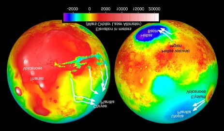
90      R. Jaumann et al.

of all the associated features. Therefore, erosion on Mars is most likely to be driven by
water, either in liquid form or as ice (see for example [7, 8, 10]). This led to the as-
sumption that liquid water might have been stable on the surface in the past history of
Mars (see for example [5, 6, 9, 10]). Thus, besides Earth, Mars is the only planet with a
record of resurfacing processes and environmental changes that indicate the past op-
eration of a hydrologic cycle. Although the large-scale morphology of the Martian
channels and valley networks show remarkable similarities with fluid-eroded features
on Earth, there are major differences in their size, small-scale morphology, inner chan-
nel structure and source regions, indicating that the erosion on Mars has its own char-
acteristic genesis and evolution. The details of the channel forming processes are still
unknown.

6.1 Outflow Channels
Outflow channels are several to tens of kilometers across, reaching lengths of a few
hundred to thousands of kilometers with gradients of channel floors (Fig. 6.1) ranging
from 0 to 2.5 m/km [10]. Tributaries are rare, but branching downstream is common
resulting in an anastomosing pattern of channels [7]. The channels tend to be deeper at

Fig. 6.1 Outflow channels near the highland volcano Hadriaca Patera. The close proximity of
the collapse features and the volcano (caldera at upper left of the image) suggests an origin by
volcano-ice interactions [e.g., 95]. From left to right: Dao Vallis, Niger Vallis, and Harmakhis
Vallis, each one more than 1 km deep and 8-40 km wide. MOC wide angle image, width
~800 km, centered at 40 °S, 270 °W, north toward left, illumination from lower left
(NASA/JPL/Malin Space Science Systems).
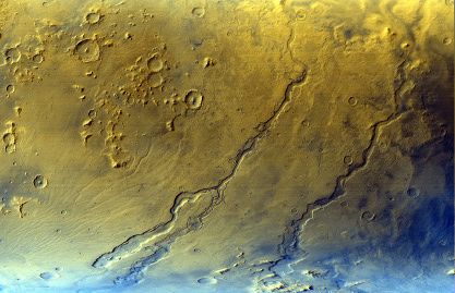
6 Geomorphological Record of Water-Related Erosion on Mars            91

their source than downstream and in general have a high width to depth ratio and low
sinuosities [7, 10]. Isolated upland remnants separating channels, mesa-like remnants
at channel borders, hanging valleys, transected divides, and expansions and constric-
tions of the channel beds are common. A variety of bedforms are located on the floors
of outflow channels [5, 9, 10, 30-35] such as residual or recessional headcuts, scour
marks, longitudinal grooves, which parallel the presumed flow direction, teardrop-
shaped islands, inner channels, terraces, cataracts and plucked zones, similar to sca-
bland topography, which form by stripping away surface materials due to high-velocity
turbulent fluid flow [5]. Outflow channels are common in the vicinity of the Chryse-
Acidalia basin, west of the Elysium volcano complex in Elysium Planitia, in the east-
ern part of Hellas basin and along the western and southern border of Amazonis Plani-
tia. All these channels are denoted as outflow channels, even though their occurrence,
source regions and geological context differ from area to area. By far the largest chan-
nels occur around the Chryse Basin. Outflow channels in this area start in the cratered
Xanthe Terra uplands (Fig. 6.2) or on high volcanic plains and converge in the Chryse
Basin mainly from the south but also from the southeast and west. On the Chryse
plains they broaden and finally disappear at about 40 °N latitude. Most of the outflow
channels around Chryse emanate fully developed from circular to elliptical depressions
termed chaotic terrain [36]. These areas are 2-5 km below the surrounding undisturbed
terrain and mostly covered with large jumbled blocks of material from the former
surface. This indicates that the chaotic terrain have formed by collapse rather than by
removal of material from the above, indicating the involvement of groundwater in the
channel formation process. Many of the chaotic terrain east of the Valles Marineris
merge westward with the canyon system and northwards with outflow channels. How-
ever, particularly to the north of the Valles Marineris, channels tend to emanate from
completely enclosed canyons containing chaotic terrain like Echus, Hebes, Juventas
and Ganges Chasma. The context of the Chryse channels source regions with the Valles
Marineris canyon system suggests a close correlation between canyon tectonics and
channel formation. In the Elysium region large outflow channels originate at fractures
oriented radial to the west and northwest flanks of the Elysium volcano complex. The
channels mostly start at elongated depressions. Outflow channels also occur at the
eastern flank of the Hellas basin adjacent to the old volcano Hadriaca Patera.

6.2 Valley Networks
Open branching valleys, in which tributaries merge downstream, are common in the
southern highlands. The number of branches is low with large undissected areas be-
tween individual branches. The networks themselves are spaced apart leaving large
areas of undissected highland between them [23], indicating that there has been no or
only little competition between adjacent drainage basins [37]. The main characteristics
of individual branches are their U-shaped form with flat floors and steep walls. They
differ from channels by the absence of bed-forms, which are indicators for fluid flow
[9]. Some valleys are several hundreds of kilometers in length and a few tens of kilo-
meters wide with short accordant tributaries such as Nirgal Vallis. However, the ma-
jority of the valleys is typically no longer than 200 km and only a few kilometers wide.
92      R. Jaumann et al.

The valley networks are mainly located in the cratered uplands, the oldest Martian
terrain, at elevations ranging from 2 km to over 5 km. Some valley networks drain into
craters, but most of them start at local heights and drain as winding streams with rela-
tively large junction angles of branches into low areas between large impact crater
where they terminate against smooth plains [38]. At the upland/lowland boundary
regions, the valley networks tend to drain northward (Fig. 6.3). Valleys in the Noachis

Fig. 6.2 Nanedi Vallis is a valley system in the ancient cratered plains of Xanthe Terra. Terraces
and the small inner channel within the canyon (near top of image) suggest continuous flow and
down-cutting. Other morphologic features, however, indicate a formation by collapse: the lack
of small contributing valleys on the surrounding plateau, box- or amphitheater-headed short side
valleys, and the form of the meanders. It seems possible that both sustained flow and collapse
formed the valley. Image width is ~10 km, illumination is from the left (NASA/JPL/Malin Space
Science Systems/RPIF/DLR).
6 Geomorphological Record of Water-Related Erosion on Mars                 93

region are mostly oriented northwest into the low-laying region of chaotic terrain east
of Valles Marineris. Around Hellas the valley networks are focussed radial to the basin
and valley networks in the south pole region drain north towards the Hellas and Agyre
Basins. Another set of channel networks occurs on volcanoes. Although channels on
volcanoes usually are caused by lava or volcanic density flows so called nuée ardentes
[39], there is evidence that valleys on Alba Patera, Ceraunius Tholus and Hecates
Tholus as well as on Hadriaca, Thyrrena and Apollinaris Patera are compatible with a
fluvial origin [40-42]. These valleys are narrower and shallower as their counterparts
in the uplands and show a more dense drainage pattern with small junction angels. At
some places the walls of canyons are deeply incised by V-shaped valleys that lack de-
posits at their mouth within the canyon [7]. In particular at the upland/lowland bound-
ary between about 290°-360 °W and 30°-50 °N a specific type of terrain is exposed. In
this area the northern plains interfere in a complex way with the highlands. Numerous
islands with 1-2 km high escarpments are isolated from the uplands [43]. The isolated
mesa-like islands are surrounded by aprons with well-developed flow fronts [44]. Flat-
floored, broad(up to 20 km wide) and steep-walled channels reach deep into the up-
lands. These fretted channels branch upstream as do valley networks. Some of these
channels have longitudinal ridge-like features on their floors, indicating compressional
features caused by merging aprons from the walls [44] and removal of material
through the channel by mass wasting downstream [38]. Furthermore, processes of
undermining and collapse seem to have been involved in forming the fretted channels
[45].

Fig. 6.3 Global elevation map based on MOLA data. White arrows show the main flow direc-
tions of water or ice within the outflow channels. Note the spatial proximity of channel source
areas to volcanic centers in Tharsis, Elysium, and Hellas.
94      R. Jaumann et al.

6.3 Periglacial and Permafrost Landforms

6.3.1    Debris Flow and Terrain Softening

Steep topographic scarps often dissect the terrain at the transition from the southern
cratered uplands towards the northern lowlands. At their base, well-defined flow fronts
with convex-upward surfaces extend into the low-lying plains [43]. These lobate de-
bris aprons have been attributed to gelifluction and/or frost creep [46]. The water
content in this mixture of rock and ice might be derived from the atmosphere [44], or
from ground ice by sapping or scarp collapse [45]. Where flow fronts from opposing
walls collide, e.g., in valleys, linear ridges and grooves cover the whole valley floor.
This so-called lineated valley fill resembles terrestrial median moraines on glaciers
(Fig. 6.4).
   A certain type of surface modification by viscous creep of material is found in both
hemispheres at latitudes between 30° and 60°. The effects are most obvious at craters:
Fresh impact craters have clearly defined, crisp rims. In some places, however, crater
rims appear to be subdued or rounded and small craters are only sparsely visible [47].
In other places, material has obviously moved down the inner crater wall by creep, not

Fig. 6.4 Lineated valley fill in fretted terrain at 34.4 °N, 302.0 °W. Detail of MOC image
46704, image height 5.5 km (resolution 13.2 m/pixel), illumination is from above
(NASA/JPL/Malin Space Science Systems).
6 Geomorphological Record of Water-Related Erosion on Mars             95

by fall, and forms what is called concentric crater fill. These and other types of terrain
softening are mostly seen in a latitudinal belt between 30° and 60° [7, 48, 49]. This
might be due to the fact that ice is not in equilibrium with the present atmosphere at
lower latitudes [49]. On the other hand, at very high latitudes > 60° the temperature are
very low and, correspondingly, the high strain rate of ice prevents flow.
   The viscous flow of material on Mars has been compared to terrestrial rock glaciers
[e.g., 50, 51], which are accumulations of angular rock debris and move down due to
deformation of internal ice or frozen sediments [e.g., 50, 52]. Squyres [50] calculated
that near surface flow (in a viscous layer less than 5 km deep) is probably responsible
for the formation of the flow features.

6.3.2    Ground Ice

The huge difference between the water volumes inferred by the morphological evi-
dence of water release on the surface (chaotic terrain, outflow channels) on one hand
and the present inventory of volatiles (mainly polar caps) on the other hand implies that
large amounts of water infiltrated the Martian megaregolith. The old mega-regolith
where the ground ice is mainly found, is a global blanket of fractured and blocky mate-
rials up to 2 km thick as a consequence of impact cratering during the primordial bom-
bardment. It can be inter-bedded with ice layers, lava flows or sedimentary deposits
[31]. If the pores are filled with ice, and if a decrease of the porosity with increasing
depth is taken into account, the Martian ground ice would correspond to a global layer
of water at least 400 m deep [53].
   Given a mean annual surface temperature of –60 °C, a 6 mb atmospheric pressure
and a dry periglacial–type climate, the present ground ice on Mars should be stable at
some depth over virtually the entire planet. Its total thickness depends on the mean
annual surface temperature, on the geothermal heat flow, the thermal conductivity of
the material, and the ground ice melting temperature. Permafrost thicknesses from 3 to
7 km near the poles and between 1 and 3 km near the equator seem possible [54]. Liq-
uid water should exist under the ground ice, at least at mid-latitudes.

6.3.3    Rampart Craters

The particular morphology of some impact crater ejecta blankets provides very strong
evidence for subsurface volatiles on Mars. On the Moon with its dry crust, the frag-
ments ejected by an impact follow ballistic trajectories. Consequently, they form a
continuous blanket with a rough surface near the crater, slowly grading outward into
secondary craters. In a completely different and characteristic pattern, the ejecta of so-
called rampart craters on Mars are marked by distinct lobes. Because they seem to
have flown around pre-existing obstacles, it has early been suggested that the entrain-
ment of subsurface volatiles - most probably water - has caused the ejecta to flow over
the surface [7, 11, 55].
    Not all impact craters show lobate ejecta blankets, and rampart craters are not dis-
tributed randomly over the Martian surface. This observation has led to several efforts
to map the volatile content in the subsurface based on rampart crater morphologies.
96 R. Jaumann et al. Very small craters with diameters less than a few kilometers never have lobate ejecta. The impacting bodies obviously were not large enough to penetrate the uppermost dry surface layer of the planet. Kuzmin et al. [56] used the minimum diameter of craters with rampart ejecta to map the global distribution of the ground ice table, i.e. the depth, at which water is present. They found smaller onset diameters for rampart formation at higher latitudes, indicating water at shallower levels. Other workers have investigated the ratio of the ejecta blanket versus the diameter of rampart craters. The basic idea is that a larger water content should result in a larger ejecta blanket (having flown farther outward) for a given crater diameter. A correlation of larger ratios with higher latitudes has been found [12, 56-59], again indicating more near-surface water in mid- and high latitudes, mainly in the northern plains [7]. Par- ticularly conspicuous concentrations of rampart craters with high ratios of ejecta to diameter have been noted in large topographic depressions or basins more than 4000 m below the Martian datum near the mouth of outflow channels in Utopia and Acidalia Planitiae [60, 61]. 6.3.4 Polygons Giant polygons have been found in several locations on Mars: The best examples can be observed near the mouths of outflow channels in Acidalia, Elysium, and Utopia Planitiae [62-64], and less developed or smaller features were identified in the Valles Marineris [65] and in very high latitudes north of 70 °N [59]. The diameters of the giant polygons are in the range of 30 km [e.g., 62, 66-68], and the average width and depth of troughs bordering the interior of polygons in Utopia Planitia is 2 km and 30 m, respectively [69]. Their genesis was attributed to various models, all involving cracking of the surface in response to tension. Based on terrestrial analogy, McGill and Hills [70] proposed cooling and dessication of wet sediments deposited at the termina- tion of outflow channels to account for polygon formation. Many recent Mars Observer Camera (MOC) images show well-developed polygons with relatively small diameters of 10-100 m (Fig. 6.5). They were already identified in Viking images and are interpreted to be the result of thermal contraction in ice-rich soils based on the similar scales as compared to terrestrial ice-wedge polygons [68, 71- 73]. Theoretical considerations by Mellon [74] support the formation of polygons by thermal contraction at mid and high latitudes. 6.3.5 Thermokarst Thermokarst features form by the melting of ground ice and subsequent surface col- lapse. They are typically found in periglacial alluvial plains or in glaciofluvial outwash plains. On Mars, possible thermokarst was first noted by Sharp [43] and Anderson et al. [75] who noted the similarity of some Martian depressions to thermokarst features like thaw lakes or alases in Alaska and Siberia. In more recent studies based on high- resolution Viking Orbiter and MOC images, Costard and Kargel [61, 76] support the thermokarst interpretation and report particularly high concentrations in
6 Geomorphological Record of Water-Related Erosion on Mars                97

Fig. 6.5 Patterned ground on the floor of an impact crater in the northern plains of Mars. The
polygons might have formed by repeated freeze-thaw cycles of subsurface ice. MOC image
release MOC2-150 (NASA/JPL/Malin Space Science Systems).

Utopia Planitia, the same region where polygonally fractured ground and small rampart
craters are frequently found. Another thermal erosion process has been proposed as a
typical situation along most outflow channels. Fluvial-thermal erosion, occurring
along most arctic rivers, might enlarge outflow channels by a combination of thermal
and mechanical erosion along frozen riverbanks [77]. Lateral erosion produces ther-
mokarstic subsidence that favors collapsed blocks.

6.4 Glacial Landforms

6.4.1    Eskers and Moraines

Glaciation was considered to be responsible for producing specific landforms on Mars
for a long time [e.g., 53, 78-81]. However, it was not before the early 1990’s when the
first integrated sequence of glacial features in Argyre, Hellas, the south polar region,
and the northern plains was reported. Kargel and Strom argued in a series of papers
98      R. Jaumann et al.

[e.g., 82-84] that only glaciation can account for these features in a simple and unify-
ing way, and they point out that otherwise many different and unusual processes would
have to work independently to explain them.
   According to Kargel and Strom, long curvilinear ridges in mid and high latitudes
provide striking morphological evidence for ancient glaciation. A formation as eskers
seems plausible [e.g., 83, 85-88]: Eskers are elongated sinuous ridges of glacifluvial
sand and gravel and form as infillings of sub-glacial, en-glacial, or supra-glacial rivers.

6.5 Volcano Ice Interactions
Early in the Viking mission, several workers noted landforms which might be related
to volcano-ice or volcano-groundwater interactions [e.g., 78, 89-91]: Table mountains
at high northern latitudes resemble Canadian tuyas and Icelandic flat-topped mountains
with steep sides which developed from sub-glacial volcanic eruptions and are the sub-
glacial equivalents to shield volcanoes. Elsewhere on Mars, ridges and mountains have
been compared to terrestrial móberg ridges consisting of sub-glacially erupted mate-
rial.
   The interaction of volcanic heat and ground ice might be responsible for the close
spatial proximity of braided channels with streamlined islands to the Elysium volca-
noes [92, 93). Chapman [94] found evidence for móberg ridges, table mountains, and
jökulhlaup deposits and proposed the existence of a paleo-ice sheet northwest of the
Elysium volcanoes in Utopia Planitia. Northeast of Hellas, the source regions of some
outflow channels (Fig. 6.1) close to the ancient highland volcano Hadriaca Patera also
suggest that channel formation has been triggered by volcanic activity [95].

6.6 Chronology of Martian Erosional Processes
The stratigraphic position of geologic units on Mars is estimated by the means of su-
perposition and intersection relations and by the concentration of impact craters super-
posed on geologic units [20]. Three major time systems are defined, throughout which
the surface has been formed: Noachian, Hesperian and Amazonian. Due to the lack of
samples from Mars, the assignment of absolute ages to the epochs is based on crater
densities depending on cratering rates [20, 96-98] and thus is model dependent. Differ-
ent models define the Amazonian-Hesperian boundary between 1.8-3.5 Ga ago and the
Hesperian-Noachian boundary between 3.5-3.8 Ga ago [96, 98, 99].
   The relatively small size of Martian valleys, the modification by aeolian processes
and the not sufficient coverage of high-resolution imagery makes it difficult to use
crater counting for age determination. However, in some places, particularly on the
floors of large outflow channels, it was possible to estimate crater retention ages [21,
96, 100, 101). Neukum and Hiller [96] performed crater counts on units (surround-
ings and floors) of Chryse channels such as Kasei, Ares, Tiu and Maja Vallis, Elysium
channels such as Hrad Vallis and Elysium Fossae, one channel NE of Hellas and Ladon
Vallis north of the Agyre basin, taking into account data from other authors [21, 44,
102]. As expected, they estimated the channel surroundings to be significantly older
6 Geomorphological Record of Water-Related Erosion on Mars              99

than the measured channel ages. The number of craters with 1 km diameter N(1) per
square kilometer are for the surroundings either >4×10⁻² (km-2) representing the early
crust or 2×10⁻³ (km-2) to 2×10⁻² (km-2), representing a younger resurfacing period.
This translates to crater model ages as proposed by Neukum and Hiller [96] of 3.6 to
4.1 Ga and to more than 4.2 Ga, respectively. In the following, crater model ages will
refer to the Neukum and Hiller [96] Model I. However, it is mentioned that these ages
are model dependent and may be accurate only within a factor of two for younger units.
The estimated ages of channel floors range from N(1) = 1×10⁻² (km-2) to 1×10⁻⁴ (km-2)
or 3.9 to 0.4 Ga, the bulk lying between 3.8 and 3.1 Ga. The very young ages measured
most probably represent post-erosional fillings. There is evidence that channel resur-
facing was going on during two separate phases with the cratering age of 3.1 Ga
marking the end of the first phase [96]. The valleys that belong to the older group such
as Maja, Ares, Ladon and Hard Vallis have crater retention ages ranging from 3.9 Ga to
3.1 Ga. The younger group exhibits valley units with crater model ages of 3.1 Ga and
about 0.4 Ga. The data from Neukum and Hiller [96] also show a sequence of the
circum-Chryse valles with most of the Kasei Vallis floors being oldest followed by the
mouth of Maja Vallis, Ares Vallis, Tiu Vallis and the mouth of Kasei as the youngest
unit in this area. Marchenko et al. [101] suggest four major stages of fluvial activities
and resurfacing in the Chryse region, indicating episodic events of flooding. Robinson
et al. [100] concluded that some areas of Ares Vallis were formed prior to 3.5 Ga ago
and have been later reworked between 2.2 Ga ago and 1.6 Ga ago. However, channel
floors are modified by post-fluvial mass wasting and aeolian processes, making it
difficult to clearly address younger floor units to flood events. Neukum and Hiller [96]
concluded that the major channel formation took place between 3.8 Ga and 3.1 Ga ago.
Channels on volcanoes are too small for crater counting on their floors, but they dis-
sect volcanic units for example at the flanks of Alba Patera as young as 0.5 Ga. The
resolution and coverage of existing imagery restrict the available age data, which can
be derived by crater counting. Thus, only a small amount of channels and almost no
valley networks are dated by this method. In order to get a better statistics of the distri-
bution of channels in time, we used the relative relationship of superposing units and
intersections. A channel that is superposed on a geologic unit must be contemporane-
ous with or younger than that unit. Branches of a channel that dissect others must be
younger. This method provides maximum ages and can be used as a first statistical
estimate of the distribution of channels and valley networks throughout time. The
analysis of intersections of different branches of the Granicus Vallis in the Elysium
region indicates that at least four episodic events have been involved in the formation
of the system. Nelson and Greeley [103] mapped the circum-Chryse channels in detail
and found the youngest units of different channels sequenced, ranging from Mawrth
and Ares Vallis being the oldest, followed by Tiu and Simud Vallis to Shalbatana Val-
lis and the youngest channel units exposed at the mouth of Kasei Vallis, indicating that
the last flood events of each channel getting younger from east to west around Chryse.
    Based on the geologic maps of Scott and Tanaka [104], Greeley and Guest [105],
Tanaka and Scott [79] and Viking imaging data, we examined the geologic relation-
ships between channels and valley networks and the surrounding units they dissect. For
a total of 65 outflow channels and individual channel branches and 276 of the largest
valley networks in the uplands the maximum relative ages have been estimated. Most
of the investigated outflow channels (70%) dissect Hesperian units with about the half
100 R. Jaumann et al. of the outflow channels having Upper Hesperian maximum ages. Amazonian units are eroded by about 25% of the outflow channels. The majority of valley networks in the uplands (about 63%) has an Upper Noachian maximum age. The formation of valley networks declined in the Hesperian (25%) and only about 12% of the valley networks, mostly valleys on volcanoes, dissect Amazonian units. Scott and Dohm [106] meas- ured intersection relations for several hundred networks and found about 70% to be older than Hesperian and Carr [38] suggested that more than 90% of the valley net- works have a maximum age older than Hesperian. Thus outflow channels and valley networks are not only separated spatially but are also delayed in time, indicating a major change in the erosion processes on Mars at the Noachian/Hesperian boundary. However, the evaluation of new high resolution MOC images gave evidence for very young small lava flows [107] and very young small-scale mass wasting processes on the walls of craters and valleys probably involving water [108]. 6.7 Standing Water A major point in the ongoing discussion about the "watery" history of Mars is whether there have ever been large bodies of standing water on the surface of the planet and if so when. This is especially important for the question of the possible existence of for- mer life on Mars. The existence of large outflow channels and extended valley networks as well as the widespread occurrence of permafrost features and features, resembling glacial and periglacial landforms makes the assumption that Mars had or still has a large inventory of water at least probable. Different climatic conditions with temperatures above freezing and a denser atmosphere, as they are proposed for the early history of Mars, would thus make large bodies of water on the Martian surface almost inevitable. Several authors have proposed the existence of an ancient ocean in the northern lowlands of Mars (see e.g., [109-111]). Parker et al. [109, 110] mapped two discon- tinuous contacts near and generally parallel to the southern boundary of the northern lowlands, based on breaks in slope, albedo boundaries and textural contacts that they interpreted to be shorelines of a former polar ocean. Head et al. [111] tried to identify those contacts in MOLA data and found the outer contact 1, exhibiting a wide range of elevations (~11 km!), to be an unlikely candidate for a shoreline. A more plausible candidate seemed to be the inner contact 2 with an elevation range of ~4.7 km and the most substantial variations occurring in regions where post-contact 2 activity has oc- curred (i.e. Tharsis, Elysium and Arabia). However, Malin and Edgett [112] who stud- ied MOC-images of the proposed shoreline found that none of the coastal landforms common on Earth are evident. A very promising feature supporting the theory of former standing bodies of water on Mars are outcrops of layered sedimentary rocks (Fig.6.6) recently imaged by MOC (see [113]). The outcrops occur in topographic lows mainly between ± 30° latitude, but there are numerous examples at higher latitudes as well. The geomorphic settings in which they appear are different and can be grouped into four types: crater interior (e.g., Becquerel Crater, Holden Crater, Gale Crater), inter-crater terrain (e.g., Terra Meridiani, Arabia Terra), chaotic terrain (e.g., Iani Chaos, Aram Chaos) and chasm
6 Geomorphological Record of Water-Related Erosion on Mars            101

interiors (e.g., Capri Chasma, Ganges Chasma, Ophir Chasma etc.).
   Paleolacustrine environments had already been widely recognized on the surface of
Mars especially putative crater lakes, which often exhibit well developed sedimentary
landforms (see e.g., [114-121]). Aqueous sedimentary deposits in Gusev Crater were
described by Cabrol et al. [118] such as deltaic structures from the inflowing Ma'adim
Vallis as well as streamlined terraces, layers and channels observed on the central
sedimentary deposits in Gale Crater [119, 120]. Ori et al. [121] described Gilbert-type
deltas at the mouth of channels debouching into craters in Ismenius Lacus and Mem-
nonia Fossae.
   Finally, the Argyre and Hellas basins, the two largest impact craters on Mars, have
also often be discussed as depositional basins with areas ranging as high as 3×10⁶ km2
for the Hellas Basin (see e.g., [115, 122, 123]). Numerous channels and valley net-
works terminate in the areas and large sedimentary deposits as well as local debris
flows within the deposits, attested to concentrations of groundwater in the basins, have
been identified.
   Many of the described features as well as crater counting of the deposits and sur-
roundings indicates that some lakes might have been active for long time periods of at
least thousands of years [e.g., 121] up to 1-2 Ma [118]. This lead to the assumption
that the climatic settings were different from those prevailing today.

6.8 Origin of Martian Surface Erosion
    and Implications for the Palaeoclimate
The source regions of the outflow channels are directly related to tectonics and in the
Elysium and Hellas region to volcanic features. This evidence together with the fluid-
like erosion features of the channels indicates that there is a close correlation with fast
groundwater release triggered by melting of ground ice, tectonical thinning of the
cryosphere and thereby provision of easy access of groundwater to the surface. Com-
pared to alternate hypothesis such as lava erosion, wind erosion or erosion by other
fluids like liquid hydrocarbons, the hypothesis, which accounts for most of the ob-
served channel features is the catastrophic release of groundwater or drainage of sur-
face lakes [10]. The dimensions of the outflow channels indicate discharges in the
order of 107-109 m3s-1 [5, 31, 124, 125]. This is about two orders of magnitude larger
as the largest known flood events on Earth, such as the peak discharges of the Chan-
neled Scabland flood of eastern Washington or the Chuja Basin flood in Siberia [10,
126]. Several processes are discussed that may cause large floods on Mars. Ground-
water under high artesian pressure confined below a permafrost zone may break out,
triggered by events, which disrupt the permafrost seal, such as impacts or Mars-quakes,
either by breaking the surface or sending a large pressure pulse through the aquifer [7,
31, 38]. This hypothesis needs a thick permafrost layer in order to build up the artesian
pressure and is consistent with climatic conditions similar to those of present day
Mars. Another argument for this mechanism is the low elevation of the outflow chan-
nel source regions compared to the high groundwater level of the regional aquifer
system [7], which provides hydrostatic pressure. After groundwater release, floods
would decline as the artesian pressure drops and finally come to an end when the aqui-
102 R. Jaumann et al. fer reseals by freezing and water can no longer reach the surface. The duration of mas- sive flood events is short and has been estimated to last a few days to several weeks depending on the discharge rates [see 7]. If the aquifer was recharged by groundwater flow from distant sources, the flood could reoccur, resulting in episodic events of catastrophic groundwater release. Fig. 6.6 Hundreds of layers of the same thickness characterize the interior of an old impact crater in Arabia Terra. The repeated changes between single layers indicate repeated changes in the depositional environments. A plausible process which may have formed these deposits is sedimentation in a standing body of water. Image width is about 3 km (NASA/Malin Space Science Systems/RPIF/DLR). Another water release process may be the melting of ground ice by volcanic heat that provides local and regional accumulation and migration of groundwater [81]. The outflow channels in proximity to the Elysium volcanoes and Hadriaca Patera near the Hellas basin are possible examples for this mechanism. A higher thermal gradient will weaken the cryosphere, providing easy access of the surface. Groundwater will also
6 Geomorphological Record of Water-Related Erosion on Mars         103

move preferentially along faults as indicated by the emergence of channels from frac-
tures in Elysium and in the Memnonia Fossae region where Mangala Vallis originates
at about 16 °S, 149 °W from a graben and continues northwards for several hundred of
kilometers into the Amazonis basin.
    Melting by volcanic heat and fracture controlled groundwater movement might also
have contributed to the groundwater accumulation around Tharsis, particularly in the
Valles Marineris region. The canyon floors are 4 to 8 km below the surroundings.
Even at a present thickness of the cryosphere of about 2.7 km at the equator [127]
water could have leaked into the canyons. New data from MOC give evidence that this
mechanism works also in smaller valleys [108]. Given a global aquifer system, it is
expected that water will pool in the canyons. As already mentioned above, layered
sediments in several canyons such as Echus Chasma and Ganges Chasma, give evi-
dence for bodies of standing water within large depressions [113, 128, 129]. Malin and
Edgett [113] proposed two climatic scenarios for the formation of the layered deposits.
The first one is based on the theory of a warmer early Mars and an environment capable
of sustaining liquid water on its surface. The second scenario proposes the modulation
of atmospheric pressure by astronomical perturbations, combined with catastrophic
modulation of sediment sources giving rise to conditions recorded by the layered sedi-
mentary deposits.
    Catastrophic release of the lakes will also form outflow channels [128]. Kasei Val-
lis is suggested to be formed by catastrophic drainage of a former lake in Echus
Chasma [125]; a large channel in Amazonis Planitia might have drained a lake in
southern Elysium Planitia [115] and Anderson [130] and Chapman [94] suggest that
Granicus Vallis, west of Elysium Mons, developed under thick ice deposits as a result
of volcanic activity. From Ganges Chasma a broad depression trends south to the cha-
otic source region of Shalbatana Vallis indicating subsurface drainage of a possible
former lake [38].
    The large outflow channels emptied into the northern lowlands and their floods
must have left extended deposits and probably large lakes. The water released by the
outflow channels to the northern plains is estimated to amount at least 6×10⁶ km3 but
probably more [131]. Baker et al. [81] calculated that it needs 6×10⁷ km3 of water to
fill up the northern plains to the 0 km-contour. The northern plains cover an older
rougher underground that survived as hills and knobs commonly outlining old pre-
plain impact craters. The plains are complex deposits probably formed by many proc-
esses such as sedimentation from outflow channels, volcanism and mass wasting from
the adjacent highlands modified by impact craters. Many of the surface features seem to
be formed by the action of ground ice.
    Outflow channels, their source regions and termination areas in the northern low-
lands provide the best evidence for surface water on Mars and a widespread ground-
water system. The outflow channels could form by running water under current cli-
matic conditions, because the large amount of released water will prevent freezing and
sublimation at least during the relatively short periods of flooding [31, 38].
    Valley networks in the uplands are much smaller than outflow channels indicating
smaller corresponding discharges. Therefore, it must be assumed that smaller branches
of the networks will freeze very rapidly and cut off downstream motion resulting in
interrupting the further development of the valleys [10]. However, the pattern of dis-
section produced by valley networks, the drainage development and the general valley
104 R. Jaumann et al. morphologies have been judged to be similar to those of terrestrial rivers and a similar origin has been implied. This led to the assumption that the valley networks mainly have formed by running water, and most of the discussion of their origin focused on the relative roles of surface runoff and sapping [4-6, 23, 132-134]. Consequently, these assumptions had implications on the evolution of the Martian climate [81, 135- 137] (for summary see [7, 10]). The valley networks are almost entirely restricted to the old uplands and the simplest explanation is that the valleys are old themselves and the climatic requirements for valley formation were met early in the planet’s history and rapidly declined during the subsequent evolution. A warmer, wet Mars with a dense atmosphere at the time after the heavy bombardment is supposed to provide the conditions for valley formation by running water. Carr [38] argued that due to the low drainage densities of valley networks, which are orders of magnitudes lower than on Earth, and the short length of the valleys combined with the probably long time they needed to form, the processes, which cause the valleys are extremely insufficient com- pared with terrestrial fluvial processes. In addition, the total absence of meter-scale flow-features and dissections in the valleys support a subsurface rather than an atmos- pheric source for the valley formation [138]. Based on the evaluation of high resolu- tion MOC images, Malin and Carr [138] concluded that the valleys have been formed by fluid erosion, but that in most cases the source has been groundwater. Relatively young small-scale alcove-like gullies combined with small channels and aprons in the walls of impact craters (Fig. 6.7), south polar pits and two of the larger valleys indicate even recent groundwater seepage and probably short-term surface runoff under almost current climatic conditions [108]). These evidences do not necessarily contradict the hypothesis of an early warm Mars, but constrain a hydrologic cycle on Mars mostly to subsurface processes. On the other hand, erosion rates declined at the end of the Noa- chian [38, 139, 140) and climate change at this time is one plausible explanation. Fur- thermore, channels on volcanoes such as on Alba Patera are interpreted to be formed by groundwater sapping in poorly consolidated pyro-clastic deposits such as ash as the result of hydro-thermal activities [41]. Gulick and Baker [42] suggested that a combi- nation of several genetic processes like water erosion, volcanic density flows and lava might have been important in the formation of those channels. Carr [38] pointed out that mass wasting in poorly consolidated ash with only little involvement of water could have formed the channels on volcanoes. Nevertheless, the channels on volcanoes are fairly young and demonstrate that the involvement of water in Martian erosion appears still lately in the planets’ history. Although it is agreed that water has been involved during the formation of the valley networks, the process itself is only poorly understood. Carr [38] stated that the flat- floored fretted channels contain abundant evidence for mass wasting based on subsur- face erosion, seepage of groundwater and creep flow of water-lubricated and subse- quently ice-lubricated debris movement downstream. Because of the resemblance of many of the valley networks to fretted channels, and the lack of evidence for fluvial activities other than plani-metric shape, Carr [38] suggested that the valleys formed like the fretted channels, mainly by water lubricated mass wasting. The high resolution MOC images so far demonstrate the need of recognizing small- scale features in order to fully understand the processes, which caused fluid-like Mar- tian erosion. However, until high-resolution stereo data with considerable areal cover- age, as expected from future missions such as Mars Express, are available, the problem
6 Geomorphological Record of Water-Related Erosion on Mars                  105

of valley and channel formation and the implications on the climate remains debatable.

Fig. 6.7 Gullies in the inner wall of an impact crater. At the base of the gullies, debris aprons
are clearly visible. These erosional landforms probably formed by a combination of groundwa-
ter seepage, surface runoff, and debris flow. They are geologically very young, as indicated by
the lack of small impact craters on the channels and aprons. Image width is about 3 km, illumi-
nation is from upper left (NASA/Malin Space Science Systems/RPIF/ DLR).

6.9 References
     1    D.U. Wise, M.P. Golombek, G.E. McGill, J. Geophys. Res. 84, 7934 (1979).
     2    G.F. Davies, R.E. Arvidson, Icarus 45, 339 (1981).
     3    D.E. Wilhelms, S.W. Squyres, Nature 309, 138 (1984).
     4    R.P. Sharp, M.C. Malin, Geol. Soc. Amer. Bull. 86, 593 (1975).
     5    V.R. Baker (Ed.) The channels of Mars, Univ. of Texas Press, Austin, 1982.
     6    M.H. Carr (Ed.) The surface of Mars, Yale Univ. Press, New Haven, 1981.
106 R. Jaumann et al.
7 M.H. Carr (Ed.) Water on Mars, Oxford University Press, New York, 1996.
8 B.K. Lucchitta, D.M. Anderson, in: Reports of Planetary Geology Program – 1980,
NASA TM-81776, 1980, pp. 271.
9 Mars Channel Working Group, Geol. Soc. Amer. Bull. 94, 1035 (1983).
10 V.R. Baker, M.H. Carr, V.C. Gulick, C.R. Williams, M.S. Marley, in: H.H. Kieffer,
B.M. Jakosky, C.W. Snyder, M.S. Matthews, (Eds.) Mars, University of Arizona
Press, Tucson, 1992, pp. 493.
11 M.H. Carr, L.S. Crumpler, J.A.Cutts, R. Greeley, J.E. Guest, H. Masursky, J. Geo-
phys. Res. 82, 28, 4055 (1977).
12 P.J. Mouginis-Mark, J. Geophys. Res. 84, B14, 8011 (1979).
13 P.J. Mouginis-Mark, Icarus 45, 60 (1981).
14 P.J. Mouginis-Mark, Icarus 71, 268 (1987).
15 L.A. Johansen, in: Reports of Planetary Geological Program, 1978–1979, NASA
TM-80339, 1979, pp. 123
16 R. Battistini, Rev. Geom. Dyn. 33, 25 (1984).
17 K.H. Wohletz, M.F. Sheridan, Icarus 56, 15 (1983).
18 J.S. Kargel, Proc. Lunar Planet. Sci. Conf. XVII, 1986, pp. 410.
19 F.M. Costard, Earth, Moon, and Planets 45, 265 (1989).
20 K.L. Tanaka, D.H. Scott, R. Greeley, in: H.H. Kieffer, B.M. Jakosky, C.W. Snyder,
M.S. Matthews (Eds.) Mars, University of Arizona Press, Tucson, 1992, pp. 354.
21 H. Masursky, J.V. Boyce, A.L. Dial Jr., G.G. Schaber, M.E. Strobell, J. Geophys.
Res. 82, 4016 (1977).
22 V.R. Baker, R.C. Kochel, Proc. Lunar Planet. Sci. Conf. IX, 1979, pp. 3181.
23 D.C. Pieri, Science 210, 895 (1980).
24 M.H. Carr, Icarus 22, 1 (1974).
25 E. Schonfeld, Eos Trans. AGU 57, 948 (1976).
26 J.A. Cutts, K.R. Blasius, J. Geophys. Res. 86, 5075 (1981).
27 D. Nummedal, in: Reports of Planetary Geology and Geophysics Program, 1977–
1988, NASA TM–79729, 1978, pp. 257.
28 D. Nummedal, D.B. Prior, Icarus 45, 77 (1981).
29 Y.L. Yung, J.P. Pinto, Nature 288, 735 (1978).
30 V.R. Baker, J. Geophys. Res. 84, 7985 (1979).
31 M.H. Carr, J. Geophys. Res. 84, B6, 2995 (1979).
32 M.H. Carr, Icarus 56, 187 (1986).
33 B.K Lucchitta, J. Geophys. Res. 87, 9951 (1982).
34 P.D. Komar, Geology 11, 651 (1983).
35 P.D. Komar, J. Geol. 92, 133 (1984).
36 R.P. Sharp, J. Geophys. Res. 78, 4063 (1973).
37 M.H. Carr, G.D. Clow, Icarus 48, 91 (1981).
38 M.H. Carr, J. Geophys. Res. 100, 7479 (1995).
39 C.E. Reimers, P.D. Komar, Icarus 39, 88 (1979).
40 L. Wilson, P.J. Mouginis-Mark, Nature 330, 354 (1987).
41 P.J. Mouginis-Mark, L. Wilson, R.J. Zimbelman, Bull. 50, 361 (1988).
42 V.C. Gulick, V.R. Baker, J. Geophys. Res. 95, 14325 (1990).
43 R.P. Sharp, J. Geophys. Res. 78, 4073 (1973).
44 S.W. Squyres, Icarus 34, 600 (1978).
45 B.K. Lucchitta, Proc. Lunar Sci. Conf. XIV, J. Geophys. Res. 89, Suppl., B409
(1984).
46 M.H. Carr, G.G. Schaber, J. Geophys. Res. 82, 28, 4039 (1977).6 Geomorphological Record of Water-Related Erosion on Mars 107
47 D.G. Jankowski, S.W. Squyres, Icarus 106, 365 (1993).
48 S.W. Squyres, J. Geophys. Res. 84, B14, 8087 (1979).
49 S.W. Squyres, M.H. Carr, Science 231, 249 (1986).
50 S.W. Squyres, Icarus 79, 229 (1989).
51 A. Colaprete, B.M. Jakosky, J. Geophys. Res. 103, E3, 5897 (1998).
52 D.I. Benn, D.J.A. Evans (Eds.) Glaciers and glaciation. Arnold, London, 1998, 734
pp.
53 S.M. Clifford, in: Reports of Planetary Geology and Geophysics Program, 1990,
NASA TM–82385, Washington, D.C., 1980, pp. 405.
54 F.P. Fanale, J.R. Salvail, A.P. Zent, S.E. Postawko, Icarus 67, 1 (1986).
55 M.H. Carr, in: D.J. Roddy, R.O. Pepin, R.B. Merrill, R.B. (Eds.) Impact and Explo-
sion Cratering, Pergamon Press, New York, 1977, pp. 593.
56 R.O. Kuzmin, N.N. Bobina, E.V. Zabalueva, V.P. Shashkina, Solar System Res. 22,
3, 121 (1988).
57 K.R. Blasius, J.A. Cutts, in: Reports of Planetary Geology and Geophysics Program,
1980, NASA TM–82385, Washington D.C., 1980, pp. 147.
58 F.M. Costard, Proc. Lunar Planet. Sci. Conf. XIX, Lunar and Planetary Institute,
Houston, 1988, pp. 211.
59 S.W. Squyres, S.M. Clifford, R.O. Kuzmin, J.R. Zimbelman, F.M. Costard, in: H.H.
Kieffer, B.M. Jakosky, C.W. Snyder, M.S. Matthews, (Eds.) Mars, University of Ari-
zona Press, Tucson, 1992, pp. 523.
60 F.M. Costard, Proc. Lunar Planet. Sci. Conf. XXV, Lunar and Planetary Institute,
Houston, 1994, pp. 287.
61 F.M. Costard, J.S. Kargel, 5th International Conference on Mars, LPI Contribution
No. 972, Lunar and Planetary Institute, Houston (CD-ROM), 1999, Abstract #6088.
62 J.C. Pechmann, Icarus 42, 185 (1980).
63 B.K. Lucchitta, H.M. Ferguson, C. Summers, J. Geophys. Res. 91, B13 (1986), Proc.
Lunar Sci. Conf. XVII, E166–E174.
64 B.K. Lucchitta, H.M. Ferguson, C. Summers, Proc. Lunar Planet. Sci. Conf. XVII,
Lunar and Planetary Institute, Houston, 1986, pp. 498.
65 K.R. Blasius, J.A. Cutts, J.E. Guest, H. Masursky, J. Geophys. Res. 82, 28, 4067
(1977).
66 G.E. McGill, Proc. Lunar Planet. Sci. Conf. XVI, Lunar and Planetary Institute,
Houston, 1985, pp. 534
67 G.E. McGill, Geophys. Res. Lett. 13, 705 (1986).
68 B.K. Lucchitta, in: Permafrost: Proc. 4th Int. Conf., Nat. Acad. Press, 1983, pp. 744.
69 H. Hiesinger, J.W. Head, J. Geophys. Res. 105, E5, 11999 (1999).
70 G. McGill, L.S. Hills, J. Geophys. Res. 97, E2, 2633 (1992).
71 T.A. Mutch, R.E. Arvidson, E.A. Binder, E.C. Guinness, E.C. Morris, J. Geophys.
Res. 82, 28, 4452 (1977).
72 N. Evans, L.A. Rossbacher, in: Reports of Planetary Geology Program, 1980,
NASA TM–82385, NASA, Washington, D.C., 1980, pp. 376.
73 G.A. Brook, in: Reports of Planetary Geology Program, 1982, NASA TM–85127,
Washington, D.C., 1982, pp. 265.
74 M.T. Mellon, Proc. Lunar Planet. Sci. Conf. XXVIII, Lunar and Planetary Institute,
Houston, 1997, pp. 933.
75 D.L. Anderson, L.W. Gatto, F. Ugolini, in: F.G. Sanger (Ed.), Permafrost: 2nd Int.
Conf., National Academy of Sciences, Washington, D.C., 1973, pp. 449.
76 F.M. Costard, J.S. Kargel, Icarus 114, 93 (1995).108 R. Jaumann et al.
77 F. Costard, J. Aguirre-Puente, R. Greeley, N. Makhloufi, J. Geophys. Res. 104, E6,
14091 (1999).
78 C.C. Allen, J. Geophys. Res. 84, B14, 8048 (1979).
79 K.L. Tanaka, D.H. Scott, Geologic map of the polar region of Mars, scale
1:15,000,000. U.S.G.S. Misc. Inv. Series Map I–1802–C, 1987.
80 D.H. Scott, J.R. Underwood, in: G. Ryder, V.L. Sharpton (Eds.) Proc. LunarPlanet.
Sci. Conf. XXI, Lunar and Planetary Institute, Houston, 1991, pp. 627.
81 V.R. Baker, R.G. Strom, V.C. Gulick, J.S. Kargel, G. Komatsu, V.S. Kale, Nature
352, 589 (1991).
82 J.S. Kargel, R.G. Strom, Proc. Lunar Planet. Sci. Conf. XXI, Lunar and Planetary In-
stitute, Houston, 1990, pp. 597.
83 J.S. Kargel, R.G. Strom, Geology 20, 3 (1992).
84 J.S. Kargel, V.R. Baker, J.E. Begét, J.F. Lockwood, T.L. Péwé, J.S. Shaw, R.G.
Strom, J. Geophys. Res. 100, E3, 5351 (1995).
85 M.H. Carr et al. (Eds.) Viking orbiter views of Mars. U.S. Government Printing Of-
fice, Washington, D.C., 1980, 136 pp.
86 A.D. Howard, in: Reports of Planetary Geology Program, 1979–1980, NASA TM–
84211, 1981, pp. 286.
87 J.S. Kargel, R.G. Strom, Proc. Lunar Planet. Sci. Conf. XXIII, Lunar and Planetary
Institute, Houston, 1991, pp. 683.
88 S.M. Metzger, Proc. Lunar Planet. Sci. Conf. XXIII, Lunar and Planetary Institute,
Houston, 1992, pp. 901.
89 H. Frey, B.L. Lowry, S.A. Chase, J. Geophys. Res. 84, B14, 8075 (1979).
90 C.A. Hodges, H.J. Moore, J. Geophys. Res. 84, B14, 8061 (1979).
91 P.J. Mouginis-Mark, L. Wilson, J.W. Head, J. Geophys. Res. 87, B12, 9890 (1982)
92 P.J. Mouginis-Mark, L. Wilson, J.W. Head, S.H. Brown, J.L. Hall, K.D. Sullivan,
Earth, Moon, and Planets 30, 149 (1984).
93 P.J. Mouginis-Mark, Icarus 64, 265 (1985).
94 M.G. Chapman, Icarus 109, 393 (1994).
95 S.W. Squyres, D.E. Wilhelms, A.C. Moosman, Icarus 70, 385 (1987).
96 G. Neukum, K. Hiller, J. Geophys. Res. 86, 3097 (1981).
97 W.K. Hartmann, Geophys. Res. Lett. 5, 450 (1978).
98 G. Neukum, D.U. Wise, Science 194, 1381 (1976).
99 W.K. Hartmann, R.G. Strom, S.J. Weidenschilling, K.R. Blasius, A. Woronow, M.R.
Dence, R.A.F. Grieve, J. Diaz, C.R. Chapman, E.N. Shoemaker, K.L. Jones, in: Ba-
saltic Volcanism on the Terrestrial Planets, Pergamon, New York, 1981, pp. 1049.
100 C.A. Robinson, G. Neukum, H. Hoffmann, A. Marchenko, A.T. Basilevsky, G.GL.
Ori, Proc. Lunar Planet. Sci. Conf. XXVII, 1996, pp. 1083.
101 A.G. Marchenko, A.T. Basilevsky, H. Hoffmann, E. Hauber, A.C. Cook, G. Neukum,
Solar System Res. 32, 425 (1998).
102 M.C. Malin, J. Geophys. Res. 81, 4825 (1976).
103 D.M. Nelson, R. Greeley, J. Geophys. Res. 104, 8653 (1999).
104 D.H. Scott, K.L. Tanaka, Geologic map of the western equatorial region of Mars,
scale 1:15,000,000. U.S.G.S. Misc. Inv. Series Map I–1802–A, 1986.
105 R. Greeley, J.E. Guest, Geologic map of the eastern equatorial region of Mars, scale
1:15,000,000. U.S.G.S. Misc. Inv. Series Map I–1802–B, 1987.
106 D.H. Scott, J.M. Dohm, Proc. Lunar Planet. Sci. Conf. XXIII, 1992, pp. 1251.
107 W.K. Hartmann, D.C. Berman, J. Geophys. Res. 82, 4067 (2000).
108 M.C. Malin, K.S. Edgett, Science 288, 2330 (2000).6 Geomorphological Record of Water-Related Erosion on Mars 109
109 T.J. Parker, R.S. Saunders, D.M. Schneeberger, Icarus 82, 111 (1989).
110 T.J. Parker, D.S. Gorcine, R.S. Saunders, D.C. Pieri, D.M. Schneeberger, J. Geo-
phys. Res. 98, 11061 (1993).
111 J.W. Head, H. Hiesinger, M.A. Ivanov, M.A. Kreslavsky, S. Pratt, B.J. Thomson,
Science 286, 2134 (1999).
112 M.C. Malin, K.S. Edgett, Geophys. Res. Lett. 26, 3049 (1999).
113 M.C. Malin, K.S. Edgett, Science 290, 1927 (2000).
114 D.H. Scott, M.G. Chapman, Proc. Lunar Planet. Sci. Conf. XXII, 1991, pp. 669.
115 D.H. Scott, M.G. Chapman, J.W. Rice, J.M. Dohm, Proc. Lunar. Planet. Sci.
Conf. XXII, 1992, pp. 53.
116 R.A. De Hon, Earth Moon Planets 56, 95 (1992).
117 H.E. Newsom, G.E. Britelle, C.A. Hibbitts, L.J. Crossey, A.M. Kudo, Icarus 44, 207
(1996).
118 N.A. Cabrol, E.A. Grin, R. Landheim, R.O. Kuzmin, R. Greeley, Icarus 133, 98
(1998).
119 N.A. Cabrol, E.A. Grin, H.E. Newsom, R. Landheim, C.P. McKay, Icarus 139, 235
(1999).
120 N.A. Cabrol, E.A. Grin, Icarus 142, 160 (1999).
121 G.G. Ori, L. Marinangeli, A. Baliva, J. Geophys. Res. 105, 17,629 (2000).
122 D.A. Crown, K.H. Price, R. Greeley, Icarus 100, 1 (1992).
123 K.L. Tanaka, G.J. Leonard, J. Geophys. Res. 100, 5407 (1995).
124 P.D. Komar, Icarus 37, 156 (1979).
125 M.S. Robinson, K.L. Tanaka, Geology 18, 902 (1990).
126 V.R. Baker, Geological Soc. of America, Boulder, SP–144, 1973.
127 S.M. Clifford, J. Geophys. Res. 98, E6, 10973 (1993).
128 J.F. McCauley, Geologic map of the coprates quadrangle of Mars, scale
1:5,000,000. U.S. Geol. Surv. Misc. Inv. Series Map I–897, 1978.
129 S.S. Nedell, S.W. Squyres, D.W. Andersen, Icarus 70, 409 (1987).
130 W.M. Anderson, LPI Tech. Rep. 92–08. 1 (1992).
131 M.H. Carr, S.C. Wu, R. Jordan, F.J. Schafer, Proc. Lunar Planet. Sci. Conf. XVIII,
1987, pp. 155.
132 D.C. Pieri, Icarus 27, 25 (1976).
133 J.E. Laity, M.C. Malin, Geol. Soc. Amer. Bull. 96, 203 (1985).
134 V.R. Baker, Spec. Pap. Geol. Soc. Am. 252, 235 (1990).
135 M.H. Carr, Icarus 56, 476 (1983).
136 S.W. Squyres, Proc. Lunar Planet. Sci. Conf. XX, 1989, pp. 1044.
137 S.W. Squyres, J.F. Kasting, Science 265, 744 (1994).
138 M.C. Malin, M.H. Carr, Nature 397, 589 (1999).
139 M.H. Carr, Proc. Lunar Planet. Sci. Conf. XXIII, 1992, pp. 205.
140 R.A. Craddock, T.A. Maxwell, J. Geophys. Res. 98, 3453 (1993).You can also read