DROACOR REFLECTANCE RETRIEVAL FOR HYPERSPECTRAL MINERAL EXPLORATION USING A GROUND-BASED ROTATING PLATFORM
←
→
Page content transcription
If your browser does not render page correctly, please read the page content below
The International Archives of the Photogrammetry, Remote Sensing and Spatial Information Sciences, Volume XLIII-B3-2021
                                                    XXIV ISPRS Congress (2021 edition)

          DROACOR® REFLECTANCE RETRIEVAL FOR HYPERSPECTRAL MINERAL
             EXPLORATION USING A GROUND-BASED ROTATING PLATFORM

                                                           ∗
                                             D. Schläpfer1 , R. Richter1 , C. Popp1 , P. Nygren2
    1
        ReSe Applications LLC, CH-9500 Wil, Switzerland - daniel@rese-apps.com, rudolf.richter@rese-apps.com, popp@rese.ch
                         2
                           SMAPS Spectral Mapping Services, 20320 Turku, Finland - petri.nygren@smaps.fi

                                                         Commission III, WG 4

KEY WORDS: Mineral Exploration, Hyperspectral Imaging, Ground-Based Platform, Atmospheric Correction, Reflectance Re-
trieval.

ABSTRACT:

The acquisition of imaging spectroscopy data from ground based rotating stages is a novel approach which is more and more used
in open pit mines for prospection and controlling. The special radiometric situation of such data sets asks for new processing ap-
proaches for geometric processing as well as for reflectance retrieval. Herein, a new method for atmospheric correction and relative
reflectance retrieval is presented which is optimized for the special horizontal scanning situation by hyperspectral instruments from
rotating ground based platforms. The method is implemented within the recently developed drone atmospheric correction frame-
work DROACOR® . It combines a physical inversion of a radiative transfer code with semi-empirical correction approaches for
illumination and spectral absorption. Sample results from two open pit mines show that mineral detection after reflectance retrieval
allows the discrimination of iron minerals and that the retrieved spectra are well comparable to standard library spectra.

                       1. INTRODUCTION                                        The calculations of path radiance and diffuse solar flux de-
                                                                              pend on this assumption. Only the direct (beam) solar ir-
The deployment of ground-based imaging spectrometers is a re-                 radiance on the ground can be used for applications with a
latively new application of remote sensing where the sensor is                horizontal view direction.
mounted on a fixed platform using a horizontal scan system to
monitor, e.g., a mining target area. The instruments applicable            • For mining applications the observed target usually is a
for these applications (e.g. SPECIM Fenix (SPECIM Spec-                      wall or hill with many small-scale facets and not a flat sur-
tral Imaging, 2021), Headwall Hyperspec (Headwall Photonics                  face. Therefore the RT output of the downwelling diffuse
Inc., 2021), Hyspex Mjolnir (Norsk Elektro Optikk AS, 2021))                 flux on a flat horizontal surface cannot be applied. Even
may cover the spectral region from 400 nm up to 2500 nm. This                the use of a DSM (Digital Surface Model) will not help,
technique has been applied for short distances, typically 50 -               because of the small pixel size (typically 5 - 20 cm) and
500 m, to identify minerals from their spectral features in open             the many orientations of the rugged terrain.
pit mines.
However, the recorded data is proportional to the measured ra-           Therefore, the challenge in atmospheric correction for short ho-
diance and a direct comparison with library reflectance spec-            rizontal distances with a large scan angle range is the unknown
tra of minerals is not possible – new reflectance retrieval ap-          path radiance and diffuse solar flux. Additional problems are
proaches are to be developed. The presented atmospheric cor-             caused by the bidirectional reflectance properties of surfaces
rection method for ground based horizontal scanning uses the             and the irregular shapes of pebbles and stones in mining areas.
LibRadtran radiative transfer code (Mayer et al., 2019) to con-          Another complicating factor is the often complex topography
vert the radiance data into relative reflectance data, which can         with vertical walls, small valleys, and reflection from opposite
be compared to libraries of mineral reflectance spectra, e.g.,           walls or hills.
from the USGS spectral libraries (Kokaly et al., 2017).
                                                                         Recently, the atmospheric correction methods have been fur-
Radiative transfer codes have been traditionally used for at-            ther evolved for close range UAV based remote sensing by
mospheric correction of optical data from airborne and space-            the DROACOR® method (Schläpfer et al., 2020), but still that
borne platforms such as in the ATCOR® method (Richter, 1998,             method relies originally on vertical observation geometry. The
Richter, Schläpfer, 2002). However, these methods are based             capabilities of the method have now been extended for short dis-
on a nearly vertical or slant viewing direction with long dis-           tances and nearly horizontal viewing conditions; denominated
tances, and they are not suitable for short horizontal distances.        as ’DROCOR-H’ in this paper. The novel features are the use of
The major differences between horizontal and vertical viewing            restricted information from a RT code, namely solar beam irra-
geometries from a radiative transfer point of view are:                  diance and transmittance of the horizontal optical path, coupled
                                                                         with a statistical correction of the scan angle influence, an auto-
    • Capabilities of Radiative transfer (RT) codes such as Lib-         mated retrieval of water vapor, an automatic absorption feature
      Radtran or MODTRAN® (Berk et al., 2004) for atmo-                  adjustment, and a spectral re-calibration with oxygen and CO2
      spheric correction were developed for a layered atmo-              absorption features. Optionally, a spectral polishing can be ap-
      sphere and airborne or spaceborne radiance simulations.            plied for post-processing to smooth remaining small spectral
∗   Corresponding author contact: daniel@rese-apps.com                   artifacts.

                                                  This contribution has been peer-reviewed.
                   https://doi.org/10.5194/isprs-archives-XLIII-B3-2021-209-2021 | © Author(s) 2021. CC BY 4.0 License.                 209
The International Archives of the Photogrammetry, Remote Sensing and Spatial Information Sciences, Volume XLIII-B3-2021
                                                XXIV ISPRS Congress (2021 edition)

        2. GROUND-BASED REMOTE SENSING                                                        3. METHOD
              REFLECTANCE RETRIEVAL
                                                                     The DROACOR-H reflectance retrieval method follows the
The geometry of ground based data acquisitions as shown in           steps as shown in Figure 2. The process starts with laborat-
Figure 1 differs significantly from airborne remote sensing: the     ory calibrated radiance imagery. Radiometric calibration may
illumination of the sun shows high variability on the typically      optionally be achieved based on standard reflectance panels, but
steep targets and the horizontal observation distance has to be      this is not recommended due to these only covering few pixels
modeled differently than with vertical observations.                 of the full image and thus not representing the truth for the rest
                                                                     of of the scan geometry. There are also other reasons that render
                                                                     in-scene reflectance panels non-practical; worst of them being
                                                                     that close to 100% reflective white panels are usually far above
                                                                     the scene reflectivity and thus force reducing the sensor dynam-
                                                                     ics to prevent saturation, which means loss of available scene
                                                                     SNR. Grey panels can be used, but they often are not as well
                                                                     characterized as the white Spectralon and may result in extra-
                                                                     polation artifacts for bright minerals. Moreover, the strict safety
                                                                     regulations of an active mine often hinder setting the panels
                                                                     close to the wall, and leave short time windows for scans con-
                                                                     ducted in the same pits with active heavy goods vehicles. The
                                                                     only practical approach for applying hyperspectral outcrop min-
                                                                     eral scanning as a support of active mining is to use algorithmic
                                                                     atmospheric correction routine such as DROACOR-H.

              Figure 1. Horizontal scan geometry.

                                                                             Meta data                  Calibrated imagery
The method implemented as part of the DROACOR® software
uses some approximations to calculate a relative reflectance
cube. The intrinsic problems with a short-distance horizontal               Atmospheric                 Spectral calibration
viewing geometry are:                                                          LUT

  • The pixel size is small (typically 5 - 20 cm), and the tar-                                       Water vapor estimation
    get is a rugged surface with many small facets oriented in
    different directions, aggravating BRDF effects.
                                                                                                       Reflectance retrieval
  • The scan azimuth angle range is large, typically up to 90◦ ,
    which can include the solar principal plane.
                                                                                                       Illumination correction
  • The foreground of the scene is also illuminated and the re-
    flected foreground radiation influences the reflected target
                                                                                                       Spectral feature fitting
    (wall /hill) radiance.

  • The scene usually also contains a sky background, another                                         Derivative polishing and
    factor influencing the target signature.                                                               band selection

  • The solar elevation angle is often low (high zenith angle),                                         Relative reflectance
    implying a low signal and signal-to-noise ratio.                                                          imagery

  • Employing an in-scene reference panel is not always prac-          Figure 2. Process flowchart for DROACOR-H ground based
    tically feasible and of limited value.                                           horizontal reflectance retrieval.

For these reasons, a strictly physical approach to convert the ra-   The meta data required for the processing are solar zenith angle
diance into surface reflectance data seems very challenging if       (based on time and location), ground altitude, and average dis-
not impossible. Some compromises and approximations have             tance to the observed object. A precalculated LUT based on the
to be made to obtain a practical solution. Factors considered in     LibRadtran radiative transfer code (Mayer et al., 2019) is used
the correction by the presented method are the gaseous absorp-       for the further calculations. It contains the necessary paramet-
tion along the optical path, the relative illumination strength      ers with a solar zenith angle between 10◦ and 70◦ for ground
(solar beam irradiance) and the impact of the observation scan       altitudes up to 3000m and sensor-to-target distances from 50 m
angle. Factors which can not be taken into account easily are        up to 500 m. The spectral range covered is 350 - 2550 nm at
the diffuse solar radiance, the adjacency effect, the complex to-    a spectral sampling distance of 0.4 nm (FWHM=0.8 nm). In
pography, and the bidirectional reflectance variations. The res-     addition, the extraterrestrial solar irradiance spectrum at me-
ulting product is not an absolute reflectance product, but rather    dium solar activity based on Fontenla (Fontenla et al., 2011) is
a relative reflectance cube, which is still sufficient for a com-    used. Our own comparisons between the LibRadtran spectra
parison with library spectra.                                        and MODTRAN® have shown a good agreeement of the two

                                                This contribution has been peer-reviewed.
                 https://doi.org/10.5194/isprs-archives-XLIII-B3-2021-209-2021 | © Author(s) 2021. CC BY 4.0 License.               210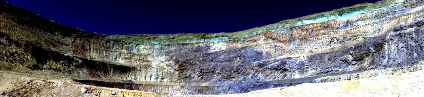
The International Archives of the Photogrammetry, Remote Sensing and Spatial Information Sciences, Volume XLIII-B3-2021
                                                XXIV ISPRS Congress (2021 edition)

radiative transfer codes within a 1% margin for the parameters
used in the DROACOR-H routine.

The processing starts with a spectral re-calibration using known
atmospheric oxygen absorption features at 760 and 1268 nm.
This step is required due to temperature-dependent spectral
shifts in most standard imaging spectrometers. A sensor spe-
cific LUT is then generated based on the shifted positions and
the spectral information from the image meta data. A water
vapor estimate is found by spectral feature fitting to the water
vapor absorption band, and is used as one value for the whole
image for the further processing. The reflectance retrieval is
a straight forward process, where the water vapor amount and
the geometric information are used to find the appropriate at-
mospheric transmittance and the scattering parameters from the
LUT for calculation of pixel reflectances. The reflectance at the
target is then derived as relation between at-target radiance to
an estimate of the irradiance.                                       Figure 3. SPECIM Fenix mine face scanning scene, example 1,
                                                                        false color composite (R:2200nm, G: 1050nm, B:610nm).
Due to the large scan angle range, typical mine face scan-
ner scenes contain strong brightness variations. These are
                                                                    range between 400 and 2450 nm, The scan angle swath is 90◦ ,
caused by changes in illumination and bidirectional reflect-
                                                                    the solar zenith angle was at 38.7◦ , and the average observation
ance (BRDF) effects. In addition, the diffuse atmospheric radi-
                                                                    distance between sensor and mine face was approximately 150
ation components (path radiance and adjacency effect) are geo-
                                                                    m. The image results show that the variability of the illumina-
metry dependent. A simplified scan angle correction approach
                                                                    tion in dependency of the observation direction can be mostly
has been included which adjusts the scan-dependent brightness
                                                                    reduced by statistical means.
per channel to the maximum brightness. The method neglects
BRDF effects and the diffuse radiation components.

The next processing steps are added to achieve realistic reflect-
ance spectra, also in atmospheric absorption regions. First,
known atmospheric absorption bands are analysed to find a best
fitting absorption curve based on the radiative LUT in an iter-
ative approach. By applying this best fit, remaining artifacts in
the spectrum can be removed. This technique is applied to all
water vapor absorption bands, the oxygen absorption features,
the CO-2 absorption bands and to spectral bands below 430nm
and above 2430nm, respectively, where strong atmospheric ab-
sorption often leads to spectral artifacts. Spectral bands with
little signal, i.e. below a given threshold of transmission are
linearly interpolated in order to support the subsequent spectral
polishing.                                                                                    DROACOR-H Reflectance

The such filtered spectra are then polished using a derivative
polishing approach (Schläpfer, Richter, 2011). This process
uses a number of 7-11 spectral bands to find a trend for the cen-
ter band by spectral derivatives on both sides while preserving
absorption features. Finally, bands with very low transmittance
and noisy bands at the edges of the detector are excluded from
the final outputs, using a combination on sensor specific user
configuration and automatic spectral adjustments. Examples of
the finally achieved spectra can be seen in the two examples
validated in the following section.

                        4. RESULTS

The method has been validated on a variety of 10 sample im-           Figure 4. Spectra taken from sample image, before and after
ages of ground based imaging spectroscopy in various mining          DROACOR-H processing: one vegetation spectrum (green) in
areas. A first example of DROACOR-H-retrieved image out-                    comparison to three mine face mineral spectra.
puts is shown in Figure 3. These images show false color com-
posites of the original scene and the scan-angle corrected rel-     Figure 4 shows the radiance and reflectance spectra of selec-
ative reflectance image. The data has been acquired with the        ted single-pixel spectral samples. One can clearly see the
SPECIM Fenix system (SPECIM Spectral Imaging, 2021) us-             iron absorption features in the blue-green and the near infrared
ing a rotational stage. It has 384 across track samples, with       wavelength regions of the mineral spectra. Also, the mineral
1547 scan lines and 362 spectral bands covering the full spectral   absorption features around 2100 nm and 2200 nm are well pro-

                                               This contribution has been peer-reviewed.
                https://doi.org/10.5194/isprs-archives-XLIII-B3-2021-209-2021 | © Author(s) 2021. CC BY 4.0 License.             211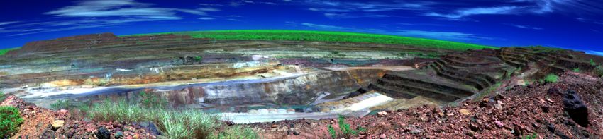
The International Archives of the Photogrammetry, Remote Sensing and Spatial Information Sciences, Volume XLIII-B3-2021
                                                XXIV ISPRS Congress (2021 edition)

nounced. The results show the applicability of the proposed           angle mapping has been applied to the raw radiance image Ls
method to the horizontal mine face scanning setup. Very reas-         and to an apparent reflectance image ρapp . The latter is calcu-
onable relative reflectance spectra results can be achieved which     lated by dividing the calibrated at sensor radiance by the av-
only exhibit small residual variations wich can be atributed to       erage estimated ground irradiance Eg ; i.e. ρapp = πLs /Eg .
atmospheric variations, e.g. at the 940nm water vapor band.           The inverse spectral angles for each of the spectra are then dis-
                                                                      played as RGB values in the three images respectively; see Fig-
In order to test the quality of the image product, a spectral angle   ure 6. Inverting the spectral angle results shows the relative
mapping with spectra of minerals known for being present in           occurrence of hematite, goethite and kaolinite by the respect-
the imagery has been performed. Three mineral spectra have            ive RGB-colors. Applying the SAM method with reflectance
been selected from the USGS spectral library (Kokaly et al.,          spectra on radiance data does not lead to useful results; this
2017), as shown in Figure 5, which are likely to occur in this        is to be expected as the spectral shapes of radiances are com-
open pit mine.                                                        pletely different than the library reflectance spectra (compare
                                                                      Figures 5 and 4). On apparent reflectance data, results are more
                                                                      realistic. However, a strong gradient in dependence of obser-
                                                                      vation azimuth and illumination can be observed. As the SAM
                                                                      method is not sensitive to spectral brightness, this effect has to
                                                                      be attributed to the unrealistic spectral shapes of the apparent
                                                                      reflectance spectra.. Figure 7 shows three sample spectra of ap-
                                                                      parent reflectance in comparison to DROACOR-H reflectance.
                                                                      No spectral polishing has been applied to the these spectra to
                                                                      show the small spectral variations present directly after atmo-
                                                                      spheric compensation. The stronger disturbances in the vicinity
                                                                      of water vapor absorption bands may have led to the poorer per-
                                                                      formance of the SAM quantification for the apparent reflectance
                                                                      data.

Figure 5. Selected USGS mineral spectra used for spectral angle
                         mapping.

                                                                        Figure 7. Comparison of three arbitrarily chosen, unfiltered
                                                                      reflectance spectra on single pixels (same pixels in both figures;
   Figure 6. Inverse SAM image for mine face example 1: R:
                                                                       top: apparent reflectance; bottom: DROACOR-H reflectance.
  Kaolinite, G: Hematite, B: Goethite. Top: based on radiance
image, Middle: based on apparent reflectance, Bottom: based on
                      DROACOR outputs                                 As a second check, the mineral reflectance spectra in Figure 5
                                                                      are compared to scene-derived spectra as shown in Figure 4.
The spectral angle mapping (SAM) as implemented in the                The mine face spectral samples in Figure 4 have been taken
GLIMPS software (Schläpfer et al., 2021) has been applied us-        at spots of relatively high occurrences for each of the miner-
ing the three spectra. For validation purposes, the same spectral     als based on the SAM results. The spectral shapes are well

                                                This contribution has been peer-reviewed.
                 https://doi.org/10.5194/isprs-archives-XLIII-B3-2021-209-2021 | © Author(s) 2021. CC BY 4.0 License.               212
The International Archives of the Photogrammetry, Remote Sensing and Spatial Information Sciences, Volume XLIII-B3-2021
XXIV ISPRS Congress (2021 edition)
tion of spectra in the foreground and some under-corrections
at the farthermost distances within atmospheric absorption fea-
tures. This is due to the fact that most spectral corrections im-
plemented in DROACOR® are based on average image spectra
which exhibit highly variable absorptions if the observation dis-
tances vary by more than 100 m.
5. DISCUSSION
The currently implemented procedure is based on a number of
rough approximations in order to get reasonable relative re-
flectance spectra. The reflectances are ’relative’ as the abso-
lute brightness is not known. Even though, the presented res-
ults show that the such processed data may lead to improved
and more stable mineral detection results. Specifically, meth-
ods based on spectral shape such as the spectral angle mapper
are well suited to be used with DROACOR-H reflectances. Re-
trieving absolute reflectances on a per pixel basis would require
an accurate prediction of the total direct and diffuse irradiance
for every facet of an image. More and more, the hyperspectral
data acquisitions are accompanied with laser scanners. This
would allow to derive the accurate irradiance angles for the ob-
served mining areas. Theoretically, such data sets would allow
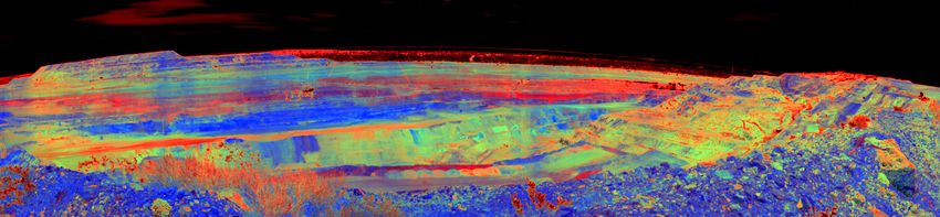
Figure 8. Open pit mine example 2, top: false color radiance
the retrieval of absolute reflectances. Problems to overcome are
((R:2200nm, G: 1050nm, B:610nm); middle: DROACOR-H
strong cross sensitivities by terrain irradiance, the extreme il-
reflectance output, same spectral bands; bottom: inverse SAM
lumination and observation angles variations, and the related
quantification with: R: Kaolinite, G: Hematite, B: Goethite.
strong BRDF effects. So, suited BRDF models coupled with
true 3-dimensional ray tracing would be required to solve that
problem. From current point of view, in-depth new research is
required to overcome these problems.
Instead of heading for a complete physical solution, one may
also try to go for a purely empirical reflectance retrieval ap-
proach. There are two solutions which may be successful:
either using in-situ reflectance panels or using image statistics.
The use of in-situ panels is common practice for ground based
imaging spectroscopy and also for drone imagery. Our analysis
have shown that if observation distances are larger than 100m,
the atmospheric effects are becoming significant, i.e. above ap-
proximately 5% relative differences in relevant spectral bands.
Spectral ranges affected are specifically the 800-900nm range,
where iron absorption features may be masked by atmospheric
effects. Therefore, panels would need to be at the very same dis-
Figure 9. Spectra taken from 2nd example image. The green
tance as the observed object for accurate reflectance retrieval.
curve is a vegetation spectrum whereas the other spectra have
For images with highly variable distances as in mining this is
been taken from within the open pit mine area.
hardly feasible. For this reason and for the reasons already men-
tioned in Section 3, the use of reflectance panels is of doubtful
reproduced after DROACOR-H correction: the purple curve in value.
Figure 4 corresponds to Hematite, the red curve to Goethite and
the blue curve to a formation with high Kaolinite abundance. Using image statics for reflectance normalisation is an approach
which is applied QUAC reflectance normalisation method
A second example scene is from an open pit mine imaged from (Bernstein et al., 2008). For medium to large scale imagery,
variable distance between 20 and 800 m, scanned with the same this method can lead to good quality relative reflectance spec-
setup as in the first example. The solar zenith angle was at 20◦ tra. The problem with its application in close-range imaging
and the ground elevation is 540 m. The resulting DROACOR-H spectroscopy is the highly variable statics between imagery and
image is shown in Figure 8. It uses the same mineral reference scenes. Each mining site is different and it is hardly feasible
spectra (Goethite, Hematite, Kaolinite; see Figure 5) for the to define comparable metrics for relative reflectance retrieval
SAM classification as in the first example. The inverse SAM based on spatial averaging. Therefore, the method is not well
classification image shows significant differences in detection applicable for the posed problem of ground based horizontal
of the various materials. If evaluating the spectra visually (see mine scanning. What remains is the presented semi-empirical
Figure 9), the resulting spectra are well comparable to the first method where physical modelling is coupled with automatic it-
example. However, the variable distances results in overcorrec- erative spectral optimization processes.
This contribution has been peer-reviewed.
https://doi.org/10.5194/isprs-archives-XLIII-B3-2021-209-2021 | © Author(s) 2021. CC BY 4.0 License. 213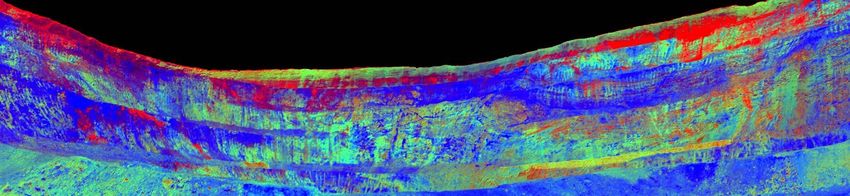
The International Archives of the Photogrammetry, Remote Sensing and Spatial Information Sciences, Volume XLIII-B3-2021
                                                XXIV ISPRS Congress (2021 edition)

                     6. CONCLUSIONS                                  Kokaly, R., Clark, R., Swayze, G., Livo, K., Hoefen, T., Pear-
                                                                     son, N., Wise, R., Benzel, W., Lowers, H., Driscoll, R., Klein,
The concept, the methodological background, and two example          A., 2017. USGS Spectral Library Version 7, US Geological Sur-
results of the DROACOR-H reflectance retrieval method have           vey Data Series 1035.
been presented. It shows that the tool allows realistic reflect-
ance retrieval from calibrated imagery even for the radiometric-     Mayer, B., Kylling, A., Emde, C., Buras, R.,
ally challenging case of horizontal scanning.                        Hamann, U., Gasteiber, J., Richter, B., 2019. lib-
                                                                     Radtran user’s guide, Version 2.0.3. available from:
A first operationally usable version is ready to be used now, but    http://www.libradtran.org/doc/libRadtran.pdf.
further improvements are about to be developed. One possible
additional feature will be an adaptive illumination correction,      Norsk Elektro Optikk AS, 2021. HySpex Turnkey Solutions.
based on shadow analysis or using a 3D digital surface models.       HySpex Mjolnir VS-620: https://www.hyspex.com (accessed
For the atmospheric parameters, the variable observation dis-        April 20th 2021).
tances for water vapor correction and a rough quantification of
the diffuse irradiance part could be helpful. Furthermore, mask-     Richter, R., 1998. Correction of satellite imagery over moun-
ing of vegetation signatures and the transition from the relative    tainous terrain. Applied Optics, 37(18), 4004–4015.
reflectances to spectral albedos using BRDF models would have        Richter, R., Schläpfer, D., 2002. Geo-atmospheric pro-
to be investigated in detail.                                        cessing of airborne imaging spectrometry data. Part 2: Atmo-
The methods developed in DROACOR® are well suited for ap-            spheric/Topographic Correction. International Journal of Re-
plications other than mineral exploration. Typical applications      mote Sensing, 23(13), 2631–2649.
would be vegetation, tree and forest border analysis. Further-       Schläpfer, D., Popp, C., Raebsamen, J., 2021. Glimps,
more, there are many potential applications in urban environ-        User Manual v1.4. ReSe Applications LLC: https://www.rese-
ments, where building faces and other built-up constructions         apps.com/software/glimps/index.html.
could be checked for damages by hyperspectral horizontal scan-
ning without the complexities always involved with airborne          Schläpfer, D., Popp, C., Richter, R., 2020. Drone Data At-
operations. Even the use of horizontal scanners from cars or         mospheric Correction Concept for Multi- and Hyperspec-
drones would be a potential applications, specifically if the cap-   tral Imagery – the DROACOR Model. ISPRS - Interna-
ability of taking the observation distance into account was ad-      tional Archives of the Photogrammetry, Remote Sensing and
ded to the method.                                                   Spatial Information Sciences, XLIII-B3-2020, 473–478. ht-
                                                                     tps://www.droacor.com.
The first version of DROACOR-H will be available for reg-
ular use by fall 2021. The module will be part of the the            Schläpfer, D., Richter, R., 2011. Spectral Polishing of High
DROACOR® software package and shares data import and                 Resolution Imaging Spectroscopy Data. 7th SIG-IS Workshop
handling routines. An additional module for the processing of        on Imaging Spectroscopy, Edinburgh, 1–7.
thermal hyperspectral data for mineral exploration is planned
soon after. Thus, the DROACOR® software will soon help to            SPECIM Spectral Imaging, 2021. Fenix. SPECIM Fenix:
process close range imaging spectroscopy data to reflectance         https://www.specim.fi/products/fenix/ (accessed April 20th
quantities with higher reliability and repeatability than standard   2021).
reflectance normalisation approaches.

                        REFERENCES

Berk, A., Anderson, G. P., Acharya, P. K., Bernstein, L. S.,
Muratov, L., Lee, J., Fox, M. J., Adler-Golden, S. M., James
H Chetwynd, J., Hoke, M. L., Lockwood, R. B., Gardner, J. A.,
Cooley, T. W., Lewis, P. E., 2004. MODTRAN5: a reformulated
atmospheric band model with auxiliary species and practical
multiple scattering options. S. S. Shen, P. E. Lewis (eds), Re-
mote Sensing of Clouds and the Atmosphere XXIII, SPIE, 341–
347.
Bernstein, L., Adler-Golden, S., Sundberg, R., Ratkowski,
A. J., 2008. In-scene-based atmospheric correction of
uncalibrated VISible-SWIR (VIS-SWIR) hyper- and
multispectral imagery. Proceedings of SPIE, 7107, 7. ht-
tps://doi.org/10.1117/12.808193.
Fontenla, J. M., Harder, J., Livingston, W., Snow, M., Woods,
T., 2011. High-resolution solar spectral irradiance from extreme
ultraviolet to far infrared. Journal of Geophysical Research,
116(D20).
Headwall     Photonics      Inc.,  2021.     Hyperspectral
Sensors:      Hyperspec MV.X. Headwall Hyperspec:
https://www.headwallphotonics.com/hyperspectral-sensors
(accessed April 20th 2021).

                                                This contribution has been peer-reviewed.
                 https://doi.org/10.5194/isprs-archives-XLIII-B3-2021-209-2021 | © Author(s) 2021. CC BY 4.0 License.           214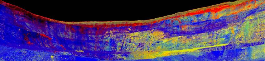
You can also read