E3SM: The Energy Exascale Earth System Model
←
→
Page content transcription
If your browser does not render page correctly, please read the page content below
E3SM: The Energy Exascale Earth System Model
Phase 2, 2018-2022
The Energy Exascale Earth System Model (E3SM, e3sm.org) is a coupled Earth system model (ESM)
designed for use across a wide range of resolutions. Supported by the U.S. Department of Energy (DOE),
it is tailored for energy-relevant research and runs efficiently on DOE high-performance computers.

E3SM Version 1 (E3SMv1) was released to the broader scientific community in April 2018, and E3SMv2
was tagged in September 2021. E3SM is an open-development project and is engaging a growing
community of scientists.

E3SM PROJECT MISSION,                                         As a fully-coupled ESM, E3SM integrates models of the
GOAL, AND SCIENCE                                             atmosphere (EAM), land (ELM), river (MOSART), ocean
                                                              (MPAS-O), sea ice (MPAS-SI), and land ice (MALI). The
E3SM’s Mission is to reliably project decade-to-century-      development of E3SMv1, along with aspects of model
scale climate changes that could critically impact the U.S.   evaluation and applications, has been documented in 50
energy sector. Current focus areas include changes in:        peer-reviewed papers in an American Geophysical Union
• Water availability for energy production;                   (AGU) Special Collection.

• Extreme temperatures as influenced by biogeochemistry
  (via CO2 ), with impacts on the power grid;                 E3SM PHASE 2 ACTIVITIES
• Energy resource potentials for hydropower, wind, solar,
                                                              During Phase 2 (2018-2022), major parallel efforts have been
  and bioenergy; and
                                                              devoted to:
• Sea-level rise from melting ice sheets that threatens
                                                              • Evaluating and analyzing simulations from the E3SMv1
  coastal energy infrastructure.
                                                                simulation campaigns;

To provide actionable science, E3SM features:                 • Developing E3SMv2 to address v2 science questions; and

• Multi-resolution capabilities and improved process          • Developing new capabilities for integration in E3SM v3
  representations to enhance model fidelity and                 and v4.
  representation;

• Representations of human-Earth interactions to support      Evaluation and Analysis of E3SMv1 Simulations
  scenario-based modeling; and
                                                              Water Cycle
• Ensemble modeling to quantify simulation and projection
  uncertainties.                                              As part of the water cycle simulation campaign, E3SMv1
                                                              has been used to produce CMIP6 DECK simulations and
E3SM Science is organized around three science drivers        subsets of the ScenarioMIP and DAMIP simulations at “low
with simulation campaigns focused on water cycle,             resolution” (also called “standard resolution,” 100 km for
biogeochemistry, and cryosphere research. Each campaign       atmosphere and land and 30-60 km for ocean and sea-ice)
employs unique model configurations optimized to address      and HighResMIP simulations at “high resolution” (25 km for
the associated research challenges by varying their choice    atmosphere and land and 6-18 km for ocean and sea ice).
of biogeochemical species, use of variable-resolution         The simulations have been evaluated using a wide range
meshes, and targeted sensitivity experiments.                 of water-cycle metrics, with a focus on water availability in

                                                                                                                              1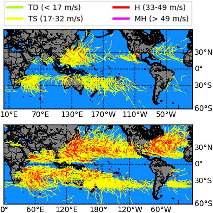
fluxes over century-length timescales that are within the
range inferred from observations. Simulations with and
without explicit representation of ocean-ice shelf interactions
have been used to address the v1 cryosphere science
question, i.e., the impacts of ocean-ice shelf interactions on
Antarctic ice sheet melt rates and Southern Ocean water-
mass properties.
The E3SMv1 and E3SMv1.1 DECK simulations have been
used in the Intergovernmental Panel on Climate Change
(IPCC) AR6 WGI report. Standard model outputs from
the simulations discussed above are available on the Earth
System Grid Federation (ESGF).
Development of E3SMv2
Building on E3SMv1, version 2 of E3SM has been
developed with a focus on improving modeling skill
and computational performance. The former has been
achieved through improvements in and better tuning of
physics parameterizations for processes such as clouds
and convection. Additionally, E3SMv2 features a new
Figure 1: Global distribution of tropical cyclone tracks simulated by
E3SMv1 at low (top) and high (bottom) resolution color-coded based on
nonhydrostatic atmospheric dynamical core for high-
the along-track intensity for tropical depression (TD), tropical storm (TS), resolution modeling.
hurricane (H), and major hurricane (MH). ( Caldwell et al., 2019 ). At high
resolution, E3SMv1 simulates more hurricanes and major hurricanes, Improvements in computational performance have been
which compares better to observations. achieved by using a faster tracer transport scheme and
using different grids for atmospheric physics and dynamics
river basins across the contiguous U.S. The all-forcing and
single-forcing experiments and low- and high-resolution
simulations have been analyzed to address the v1 water
cycle science questions of the drivers of past and future
water cycle changes and the impact of model resolution on
simulating water-cycle processes (Figure 1), respectively.
Biogeochemistry
Including representations of biogeochemistry, E3SMv1.1
has been used to produce CMIP6 DECK simulations and
a subset of the C4MIP simulations at “standard resolution”
(Figure 2). Featuring two approaches to model nutrients
in the land component, analysis has been performed to
address the v1 biogeochemistry science question of the
contribution of structural uncertainty in modeling nutrient
limitations to uncertainty in carbon-climate feedbacks.
Simulations that include only the radiative effect and
only the plant physiological effect of CO2 have been
compared to understand their relative contributions to
Earth system changes.
Cryosphere
With a new and unique capability to model ocean-ice
CLICK TO ENLARGE
shelf interactions, E3SMv1.2 is being further developed to
address the largest remaining uncertainty in projections of
Figure 2: Global carbon cycle in the E3SMv1.1-BGC model, with major
future sea-level rise, the contribution from Antarctic ice sheet carbon pools (boxes) and fluxes (arrows). Dashed lines indicate fluxes
mass loss. E3SMv1.2 simulations at “standard resolution” that are either prescribed inputs to model carbon pools or losses which
demonstrate stable, realistic Antarctic sub-ice shelf melt are not tracked further in the model. ( Burrows et al., 2020 ).
2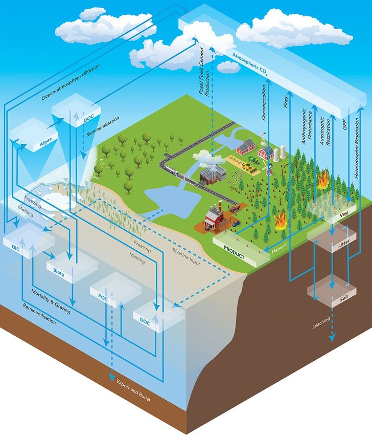
Earth and Environmental System
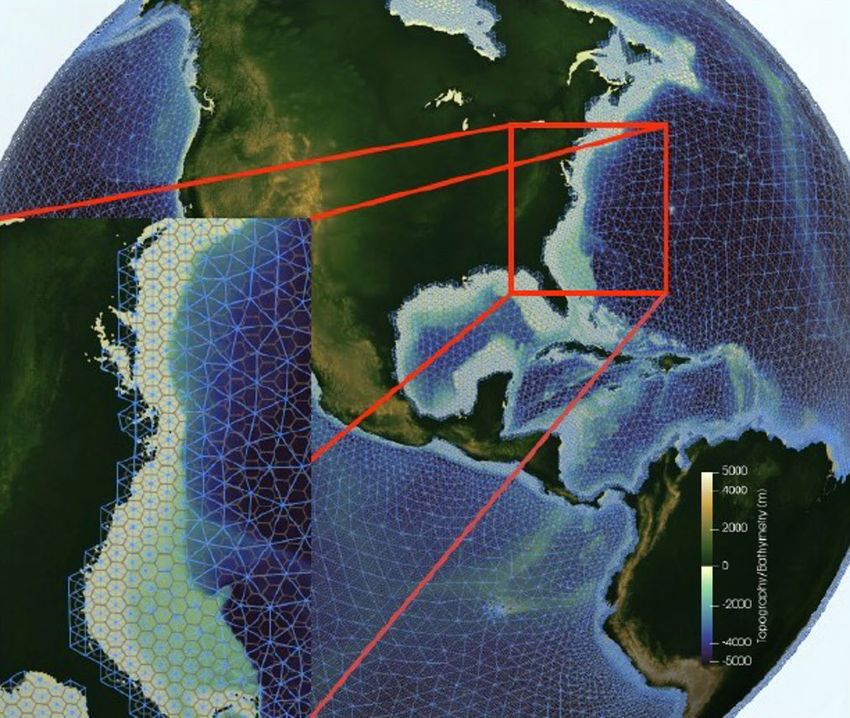
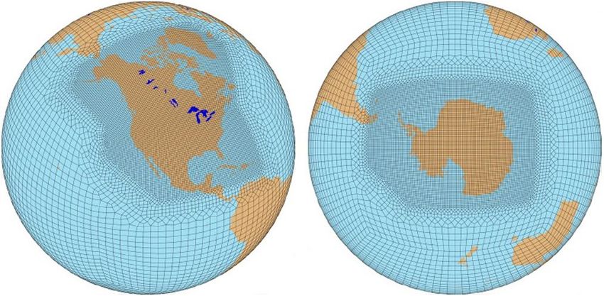
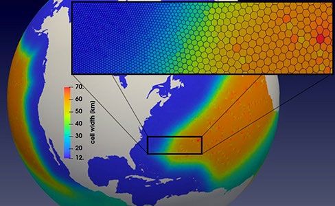
Figure 3: Regionally-refined meshes (RRMs) with high resolution over
North America (left) and Antarctica (right) and their surrounding oceans.
The number of grids in these RRMs is ~1/6 the number of grids in a
global high-resolution mesh, making RRMs more computationally
affordable for high-resolution modeling in regions of interest.
calculations. Notable improvements of E3SMv2 include
reducing the global precipitation bias by ~20%, with larger
reductions in regions such as the Amazon, and doubling the
computational throughput compared to E3SMv1.
Two regionally-refined meshes (RRMs) with high resolution
over North America and Antarctica have been tested to
support the v2 water cycle and cryosphere simulation
campaigns, respectively (Figure 3). These configurations
offer significant computational savings compared to global
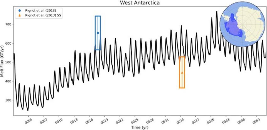
high-resolution simulations, while improving the simulations Figure 5: Top: Atmospheric winds (warm-colored streamlines), ocean
eddies (cool background colors), and sea ice concentration (grey/white)
within the RRM, such as improved Gulf Stream strength in
over Antarctica and the Southern Ocean in a simulation using the
the North America RRM (Figure 4) and more realistic sub- Antarctica RRM. Bottom: At high resolution, sub-ice shelf melt rates
ice-shelf melt rates in the Antarctica RRM (Figure 5). in West Antarctica are realistically simulated (blue and orange bars
indicate the range supported by observations), showing variability
at multiple timescales.
main analysis packages (MPAS-Analysis and E3SM
Diagnostics), new and improved tools for managing
output (zstash and E3SM_cmip), a website for exploring
performance data from simulations (PACE), a workflow tool
zppy that exploits the E3SM analysis environment (E3SM
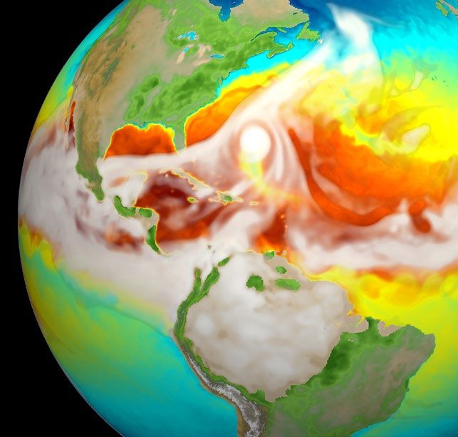
Figure 4: With resolution increasing from 60 km (orange) in the open Unified), and speedup and automation of all common post-
ocean to 14 km (cobalt) near the coast (left), the strength and separation
processing and analysis tasks for E3SM simulations.
of Gulf Stream that meanders along the east coast of North America and
the Loop Current in the Gulf of Mexico are well simulated in the North
America RRM (right).
CIME Case Control System, run_e3sm
Biogeochemistry in E3SMv2 features several new
developments, such as the capability to simulate CO2 Model Configuration Build
Submit and Run Short Term
(and Resubmit) Archive
concentration in a prognostic mode, representing water
use and management, coupling of E3SM with the Global
zstash NCO
Change Analysis Model (GCAM) to represent human-Earth Long Term
Archive E3SM-unified
interactions, and incorporating the Marine Biogeochemistry Short Term Diagnostics zppy
Library (MARBL), a modular framework for representing Archive and Analysis
E3SM_Diags
Data
biogeochemistry, into MPAS-O. Publication
MPAS-Analysis
PACE
e3sm_to_cmip6
Infrastructure (Figure 6) surrounding E3SMv2 has many
Automated data warehouse
improvements over v1, including: a shorter and simplified Data publication to ESGF
run_e3sm script for one-command model use, more
features in the CIME Case Control System for tracking Figure 6: E3SMv2 includes better infrastructure support for every phase
and controlling simulations, new diagnostics in E3SM’s of model development.
3
For comparison with E3SMv1, version 2 is being used to
    perform CMIP6 DECK simulations, which will also be used in
    combination with simulations designed for the v2 simulation
    campaign to address the v2 science questions:

    • Water Cycle: What are the relative impacts of global
      climate forcing versus regional effects of human activities
      on flood and drought risk in North America?

    • Biogeochemistry: What are the implications of different
      energy futures for the biogeochemical cycle through
      changes in land use and land cover, water availability, and
      extreme events?

    • Cryosphere: How will the atmosphere, ocean, and sea
      ice systems mediate sources of sea-level rise from the
      Antarctic ice sheet over the next 30 years?

    Next-Generation Development for E3SMv3/v4
    The E3SM project aims for future model generations
    with major innovations in both model processes and              Figure 7: An atmospheric river in a SCREAM global simulation at 3 km
    computational performance and a much higher resolution          grid spacing. Gray shading is column water vapor, and colors are
    (e.g., 3-km resolution for the global atmosphere and even       precipitation. Atmospheric rivers are responsible for most of the flooding
                                                                    events in the U.S. West Coast.
    higher resolution regionally using RRMs).

    Long-term scientific goals include the ability to more
                                                                    original Fortran implementation on conventional CPU
    accurately capture the statistics of extreme weather events,
                                                                    architectures, achieving performance portability.
    coastal features such as biogeochemical changes and
    inundation due to storm surge and sea-level changes, the        The SCREAM model provides the foundation for future
    projection of land-use and land-cover changes based on          versions of E3SM for multi-resolution applications ranging
    socio-economic pathways, dynamic ice sheets as coupled          from the “standard resolution” to coupling of a cloud-
    Earth system model components, and decadal trends in            resolving atmosphere and an eddy-resolving ocean.
    sea ice.
                                                                    The land and biogeochemistry treatments are being
    In support of these goals, new approaches and capabilities      improved to represent lateral subsurface water flows, more
    to model aerosols and chemistry, radiation, convection,         realistic vegetation, and terrestrial-aquatic processes.
    boundary-layer turbulence, and cloud microphysics are           Human energy and agricultural management practices,
    under development. These efforts have already yielded           as well as unmanaged fire disturbances, are being
    improvements in simulating the probability distribution of      incorporated in ELM-MOSART. Massively parallel ELM
    rain rates, tropical waves, ozone, and other aspects of         runs at 1-km grid spacing over North America have been
    atmospheric simulations.                                        demonstrated on GPU machines.

    The nonhydrostatic atmospheric dynamical core in                Ocean and cryosphere advances being developed include
    E3SMv2 enables ultra-high-resolution modeling to better         the addition of a wave model (Figure 8) and other coastal
    simulate clouds and convection. Combined with physics           processes, two-way coupling of dynamic, variable, and
    parameterizations tested for ultra-high resolution, the         adaptive mesh ice-sheet models, and the coupling of
    Simple Cloud-Resolving EAM (SCREAM) has been                    critical new ice-sheet model physics to climate processes.
    used to perform global simulations at 3-km grid spacing         New approaches to model mesoscale and sub-mesoscale
    (Figure 7), for participation in the DYAMOND Initiative on      eddies are being investigated. Passive tracer supercycling
    the intercomparison of global storm-resolving models.           has improved computational efficiency for modeling ocean
                                                                    biogeochemistry.
    The SCREAM model is being rewritten from Fortran to
    the C++ language. Using the Kokkos C++ library, the C++         Software and algorithm development have focused on
    code can run efficiently on both CPU and GPU machines.          improving the computational performance of the semi-
    The C++ version of the nonhydrostatic atmospheric               Lagrangian transport scheme and the ocean barotropic and
    dynamical core used in SCREAM achieves excellent                baroclinic solvers. Surrogate construction for automating
    throughput at 3 km grid spacing on the Summit GPU               the tuning of E3SM is being explored to support model
    architectures. The C++ implementation outperforms the           calibration and uncertainty quantification.

4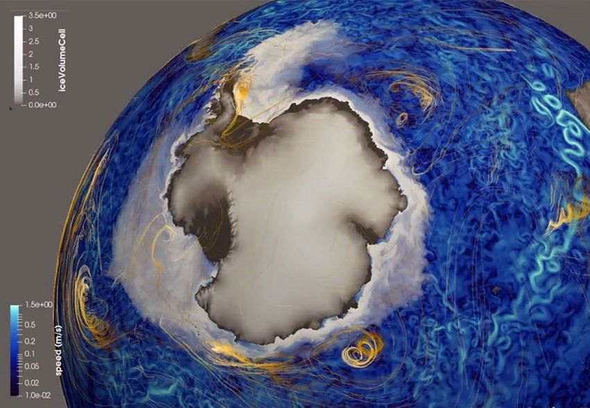
Earth and Environmental System

E3SM PROJECT ECOSYSTEM AND CODE
The E3SM core project involves coordination among more
than 100 scientists from eight DOE national laboratories
and a number of universities. E3SM is also being developed
and used broadly across university and laboratory
investigators supported by various non-E3SM DOE                             E3SM information, code, simulation
programs. Model computational work is also performed                        configurations, model output, and tools
by projects that receive Advanced Scientific Computing                      to work with the output are available at:
Research (ASCR) support, including the SciDAC BER-
                                                                            https://e3sm.org
ASCR partnership projects and ASCR’s Exascale
Computing Initiative.                                                       Model code may be accessed on the
                                                                            GitHub repository at:
                                                                            https://github.com/E3SM-Project/E3SM

                                                                            Model output data are accessible through
                                                                            the DOE Earth System Grid Federation at:
                                                                            https://esgf-node.llnl.gov/projects/e3sm

                                                                            To subscribe to the E3SM newsletter, email your
                                                                            contact information to: listserv@listserv.llnl.gov
                                                                            with “subscribe e3sm-news” in the body of
                                                                            the email message

                                                                            CONTACTS

                                                                            E3SM Program Manager
                                                                            Xujing Davis
                                                                            U.S. Department of Energy
Figure 8: A new, unstructured wave modeling mesh capability for
Wavewatch III, developed by E3SM. A new algorithm has also been             xujing.davis@science.doe.gov
developed to ensure perfect overlap of the ocean and wave meshes
near the coast (inset) to ensure accurate transmission of fluxes
                                                                            Principal Investigator
between components.                                                         David C. Bader
                                                                            Lawrence Livermore National Laboratory
                                                                            bader2@llnl.gov
PROJECT SUPPORT
                                                                            Chief Scientist
The E3SM project is sponsored by the Earth System
Model Development program area of the Earth and                             Ruby Leung
Environmental Systems Modeling Program within the                           Pacific Northwest National Laboratory
Earth and Environmental Systems Sciences Division under                     ruby.leung@pnnl.gov
DOE’s Office of Science Biological and Environmental                        Chief Computational Scientist
Research (BER). The project maintains important
                                                                            Mark Taylor
collaborations with other BER and ASCR activities.
                                                                            Sandia National Laboratories
                                                                            mataylo@sandia.gov

                                                                            Project Engineer
                                                                            Renata McCoy
                                                                            Lawrence Livermore National Laboratory
                                                                            mccoy20@llnl.gov

                                                                            https://e3sm.org
                                                                                                                                 5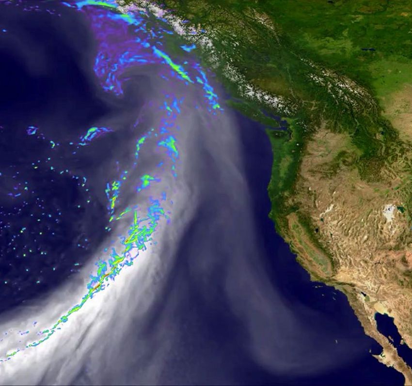
You can also read