EarthNet2021: A novel large-scale dataset and challenge for forecasting localized climate impacts.
←
→
Page content transcription
If your browser does not render page correctly, please read the page content below

EarthNet2021: A novel large-scale dataset and
 challenge for forecasting localized climate impacts.
arXiv:2012.06246v1 [cs.LG] 11 Dec 2020

 Figure 1: The EarthNet2021 dataset, an overview visualization of a single sample.

 Christian Requena-Mesa1,2,3,* Vitus Benson1,*

 Joachim Denzler2,4 Jakob Runge3 Markus Reichstein1,4
 1
 Department Biogeochemical Integration, Max-Planck-Institute for Biogeochemistry, Jena
 2
 Computer Vision Group, University of Jena
 3
 Institute of Data Science, German Aerospace Center (DLR), Jena
 4
 Michael-Stifel-Center Jena for Data-driven and Simulation Science
 *
 Joint first authors. E-Mail: {crequ, vbenson}@bgc-jena.mpg.de

 Abstract
 Climate change is global, yet its concrete impacts can strongly vary between
 different locations in the same region. Regional climate projections and seasonal
 weather forecasts currently operate at the mesoscale (> 1 km). For more targeted
 mitigation and adaptation, modelling impacts to < 100 m is needed. Yet, the
 relationship between driving variables and Earth’s surface at such local scales
 remains unresolved by current physical models and is partly unknown; hence,
 it is a source of considerable uncertainty. Large Earth observation datasets now
 enable us to create machine learning models capable of translating coarse weather
 information into high-resolution Earth surface forecasts encompassing localized
 climate impacts.Here, we define high-resolution Earth surface forecasting as video
 prediction of satellite imagery conditional on mesoscale weather forecasts. Video
 prediction has been tackled with deep learning models. Developing such models
 requires analysis-ready datasets. We introduce EarthNet2021, a new, curated
 dataset containing target spatio-temporal Sentinel 2 satellite imagery at 20 m
 resolution, matched with high-resolution topography and mesoscale (1.28 km)
 weather variables. With over 32000 samples it is suitable for training deep neural
 networks. Comparing multiple Earth surface forecasts is not trivial. Hence, we
 define the EarthNetScore, a novel ranking criterion for models forecasting Earth
 surface reflectance. For model intercomparison we frame EarthNet2021 as a
 challenge with four tracks based on different test sets. These allow evaluation of
 model validity and robustness as well as model applicability to extreme events and
 the complete annual vegetation cycle. In addition to forecasting directly observable
 weather impacts through satellite-derived vegetation indices, capable Earth surface
 models will enable downstream applications such as crop yield prediction, forest
 health assessments, coastline management, or biodiversity monitoring. Find data,
 code, and how to participate at www.earthnet.tech.

 Tackling Climate Change with Machine Learning workshop at NeurIPS 2020.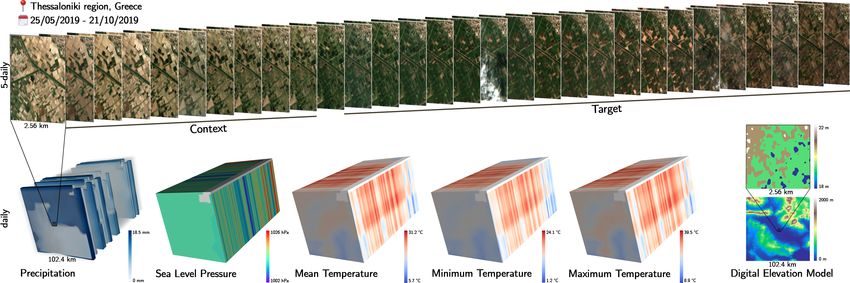
Figure 2: Predicting localized climate impacts can be done in a variety of ways. EarthNet2021 places
Earth surface prediction as an intermediate task (green path). This gives directly obtainable impacts
(NDVI) and enables further analyses to extract impacts from future Earth surface reflectance (lower
dark green path in gray box). Compared to directly modeling any given impacts, where target labels
are scarce, large amounts of satellite imagery are available. Hence, localized prediction of climate
impacts becomes feasible since self-supervised deep learning can be leveraged.

1 Motivation

The terrestrial surface of Earth is home to most of the planet’s species and houses human economical
and societal systems. As already noticed by Alexander von Humboldt, climate is a key factor shaping
vegetation cover and soils on Earth. Yet, importantly, the impact of the climatic drivers onto the surface
is highly modulated by the fine-grained local conditions, such as geomorphology, geological substrate
and vegetation and animals themselves. In particular extreme events can have very heterogeneous
impacts at the local scale depending on the conditions (Kogan, 1990). For example, ecosystems next
to a river might survive droughts better than those on south-facing slopes. However, the resolution
of seasonal weather predictions is not fine enough to deploy effective prevention and mitigation
strategies. Machine learning (Reichstein et al., 2019; Rolnick et al., 2019) can step in to increase
resolution.
Predicting localized climate impacts can be tackled in three main ways (see Fig. 2). All approaches
make use of seasonal weather forecasts (2 – 6 months ahead; Cantelaube & Terres, 2005). The
first approach (Fig. 2, path 1), aims to reconstruct hyper-resolution weather forecasts for particular
geolocations using statistical (Boé et al., 2006; Vrac et al., 2007) or dynamical (Lo et al., 2008)
downscaling, that is, correlating the past observed weather with past mesoscale model outputs and
using the estimated relationship. The downscaled weather can then be used in mechanistic models
(e.g. of river discharge) for impact extraction. However, weather downscaling is a difficult task
because it requires ground observations from weather stations, which are sparse.
A more direct way (Fig. 2, path 2) is to correlate a desired future impact variable with past data.
Doing this for tangible impacts such as on crop yield (Peng et al., 2018) again suffers from a lack of
data. An alternative is to forecast impacts obtainable from remote sensing, such as the normalized
differenced vegetation index (NDVI), yet this has only been done at coarse resolution (Tadesse et al.,
2010; Asoka & Mishra, 2015; Kraft et al., 2019; Foley et al., 2020).
Instead, we propose Earth surface forecasting as video prediction of satellite imagery with guidance
of mesoscale weather projections for forecasting localized weather impacts (Fig. 2, path 3). From
satellite imagery, we can directly observe NDVI and thus climate impacts on vegetation. Additionally,
it can also be used to extract further processed weather impact data products, such as the biodiversity
state (Fauvel et al., 2020), crop yields (Schwalbert et al., 2020), soil moisture (Efremova et al.,
2019), or ground biomass (Ploton et al., 2017). We believe Earth surface forecasting is feasible since
numerous studies suggest predicting satellite imagery works under a range of specific conditions (Zhu
et al., 2015; Das & Ghosh, 2016; Hong et al., 2017; Requena-Mesa et al., 2019; Lee et al., 2019).
EarthNet2021 aims at providing analysis-ready data and a benchmark challenge for model intercom-
parison on the broad area of Europe to accelerate model development.

 2
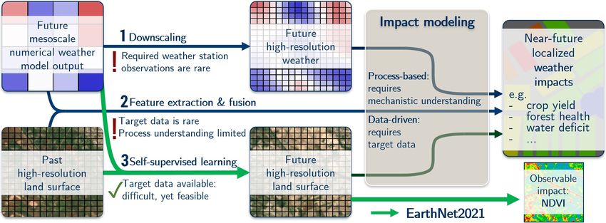
Figure 3: Panel (a) shows the spatial distribution of the multicubes in EarthNet2021. Panel (b) shows
the monthly number of multicubes and panel (c) shows the data quality measured by the percentage
of masked (mainly cloudy) pixels over both, months and latitude.

2 Data
The EarthNet2021 dataset combines three pub-
licly available EU-funded data sources into
 Sentinel 2 Dataset split
spatio-temporal data samples for training deep Metadata-based pre-filtering Quality vs. Bias trade-off
learning models. Each sample, which we call Subsampling, tile download Iterative sampling process
 Co-registration via arosics Train + 4 test sets
a data multicube, is based on a timeseries of
Sentinel 2 level 2A imagery (Louis et al., 2016) for each tile: for each cube location:

combined with a timeseries of daily climatic Data Fusion Cube generation
 E-OBS climatic variables Creating data quality mask
conditions from E-OBS (Cornes et al., 2018) EU-DEM surface model Saving compressed array
and the EU-DEM digital surface model (Bash- Reproject, resample & cut Saving data quality table

field & Keim, 2011). Training deep learning
models with raw geospatial data is usually not Figure 4: This dataset generation scheme roughly
possible and there is need for analysis-ready describes how we obtain the analysis-ready Earth-
datasets. An overview of the dataset generation Net2021 dataset from raw, public geospatial
pipeline, turning the raw geospatial data into the datasets.
analysis-ready EarthNet2021 dataset, is shown
in Fig. 4.
After data processing, EarthNet2021 contains over 30000 samples, which we call data multicubes. A
single multicube is visualized in Fig. 1. It contains 30 5-daily frames (128 × 128 pixel or 2.56 × 2.56
km) of four channels (blue, green, red, near-infrared) of satellite imagery with binary quality masks
at high-resolution (20 m), 150 daily frames (80 × 80 pixel or 102.4 × 102.4 km) of five dynamic
climatic variables (precipitation, sea level pressure, mean, minimum and maximum temperature)
at mesoscale resolution (1.28 km) and a static digital elevation model at both high- and mesoscale
resolution.
The entirety of the multicubes have been split across the training set and various test sets, which are
related to different tracks in the EarthNet2021 challenge (sec. 3). EarthNet2021 is an imbalanced
dataset, as during the data generation there is a direct trade-off between high data quality and low
selection bias. For example, high-quality (cloud-free) samples are mostly found during summer on
the Iberian Peninsula, whereas there are few consecutive weeks without clouds on the British Islands.
In Fig. 3 we try to make some of the selection bias visible by showing the spatial and temporal
distribution of the multicubes in EarthNet2021 across the different sets.

 3
3 Challenge
 ! compute
 EarthNetScore
The EarthNet2021 challenge aims at Earth sur- output
 on non-masked pixels

face forecasting model intercomparison. Due inputs
 Machine Ground truth
 & mask Pick best sample
to its novelty, there is not yet a commonly used Learning per multicube
 Model
criterion for Earth surface predictions. " Aggregate over
 ... full dataset

EarthNetScore. Specifically for Earth sur- Model performance:
 Ensemble of
face forecasting, we define the EarthNetScore 10 predictions EarthNetScore
as a ranking criterion balancing multiple goals Challenge tracks: Extreme summer Seasonal cycle
 IID ! = 10 | " = 20 ! = 20 | " = 40 ! = 70 | " = 140
in a harmonic mean as follows: OOD ! = 10 | " = 20 Feb – May | June – Nov 2017 – 2018 | 2018 – 2020
 4
 ENS = . (1)
 1
 ( MAD + 1
 OLS
 + 1
 EMD
 + 1
 SSIM
 ) Figure 5: Evaluation pipeline for models on Earth-
 The four components of ENS are the median Net2021. For predicting the tT target frames, a
absolute deviation MAD; the difference of ordi- model can use satellite images from the tC con-
nary least squares linear regression slopes of pix- text frames, the static DEM and mesoscale climatic
elwise NDVI timeseries OLS; the Earth mover variables including those from the target time steps.
distance EMD between pixelwise NDVI time
series and the structural similarity index SSIM. Test set ENS MAD OLS EMD SSIM
All component scores are modified to work prop- IID 0.26 0.23 0.32 0.21 0.33
erly in the presence of a data quality mask, nor- OOD 0.25 0.22 0.32 0.21 0.31
malized to lie between 0 (worst) and 1 (best) Extreme 0.19 0.22 0.28 0.16 0.16
and rescaled to match difficulty. Since Earth Seasonal 0.27 0.23 0.38 0.20 0.32
surface forecasting is a stochastic task models
may predict multiple future trajectories. Over a Table 1: Persistence baseline performance.
full test set, we aggregate these by only considering the best predicted trajectory per multicube (in
line with video prediction common practice). Then we average the component scores of these and
calculate the ENS by feeding the averages to eq. 1. Thus, the ENS ranges from 0 (bad) to 1 (perfect).

Tracks. Multiple models are compared within the EarthNet2021 challenge by measuring their
EarthNetScores on various tracks (see Fig. 5). The main (IID) track checks model validity. Models get
10 context frames of high resolution 5-daily multispectral satellite imagery (time [t-45, t]), mesoscale
dynamic climate conditions for in total 150 past and future days (time [t-50, t+100]) and static
topography at both resolutions. Models shall output 20 frames of sentinel 2 bands red, green, blue
and near-infrared for the next 100 days (time [t+5, t+100]). These predictions are evaluated with
the EarthNetScore on unmasked (cloud-free) pixels from the ground truth. The Robustness (OOD)
track checks model performance on an out-of-domain (OOD) test set, since even on the same satellite
data, deep learning models might generalize poorly across geolocations (Benson & Ecker, 2020).
Furthermore, EarthNet2021 contains two tracks focused on Earth system science hot topics, which
should both be understood as more experimental. The extreme summer track contains cubes from
the extreme summer 2018 in northern Germany (Bastos et al., 2020), with 4 months of context (20
frames) starting from February and 6 months (40 frames) starting from June to evaluate predictions.
The seasonal cycle track contains multicubes with 1 year (70 frames) of context frames and 2 years
(140 frames) to evaluate predictions, thus checking models applicability to the vegetation cycle.

EarthNet2021 Framework. To facilitate research we provide the EarthNet2021 framework. It
contains 1) the packaged evaluation pipeline as the EarthNet2021 toolkit which leverages multi-
processing for fast inference, 2) the model intercomparison suite, which gives one entry point for
running a wide range of models and 3) a naive baseline (cloud-free mean, see table 1) and templates
for PyTorch and Tensorflow. Further information can be found on www.earthnet.tech.

4 Outlook
Forecasting impacts of climate and weather on the Earth surface is a simultaneously societally
important and scientifically challenging task. With the EarthNet2021 dataset, first models for Europe
can be designed and the EarthNet2021 challenge offers a model intercomparison framework for
identifying their strengths and limitations. We expect deep learning based video prediction models
to be great starting points for solutions, in perspective allowing for high-resolution prediction of
localized climate impacts.

 4
Author contributions. CR and VB developed the dataset and challenge, wrote the manuscript and
created figures. CR wrote the persistence baseline and the model intercomparison framework. VB
wrote the EarthNetScore implementation and the dataset generation of EarthNet2021. JD provided
Resources and helpful comments. JD, JR and MR contributed by improving the manuscript and
with general discussion. MR steered and supervised, provided resources and helped with conceptual
design.
Acknowledgments. We are thankful for invaluable help, comments and discussions to the DLR
Climate Informatics and the MPI-BGC EIES group members, especially to Andreas Gerhardus,
Christopher Käding, Miguel Mahecha, Christian Reimers, Xavier-Andoni Tibau and Rafael Vieira
Westenberger. We are equally thankful to three anonymous reviewers. We estimate this project has
caused around 1 ton of carbon emissions, which we commit to offset.

References
Akarsh Asoka and Vimal Mishra. Prediction of vegetation anomalies to improve food security
 and water management in india. Geophysical Research Letters, 42(13):5290–5298, 2015. URL
 https://agupubs.onlinelibrary.wiley.com/doi/full/10.1002/2015GL063991.
A Bashfield and A Keim. Continent-wide dem creation for the european union. In 34th Interna-
 tional Symposium on Remote Sensing of Environment. The GEOSS Era: Towards Operational
 Environmental Monitoring. Sydney, Australia, pp. 10–15, 2011. URL https://www.isprs.org/
 proceedings/2011/ISRSE-34/211104015Final00143.pdf.
Ana Bastos, P Ciais, P Friedlingstein, S Sitch, Julia Pongratz, L Fan, JP Wigneron, Ulrich Weber,
 Markus Reichstein, Z Fu, et al. Direct and seasonal legacy effects of the 2018 heat wave and
 drought on european ecosystem productivity. Science advances, 6(24):eaba2724, 2020. URL
 https://advances.sciencemag.org/content/6/24/eaba2724.abstract.
Vitus Benson and Alexander Ecker. Assessing out-of-domain generalization for robust building
 damage detection. AI for Humanitarian Assistance and Disaster Response workshop (NeurIPS
 2020), 2020. URL https://arxiv.org/abs/2011.10328.
J Boé, L Terray, F Habets, and E Martin. A simple statistical-dynamical downscaling scheme based
 on weather types and conditional resampling. Journal of Geophysical Research: Atmospheres,
 111(D23), 2006. URL https://agupubs.onlinelibrary.wiley.com/doi/full/10.1029/
 2005JD006889.
Pierre Cantelaube and Jean-Michel Terres. Seasonal weather forecasts for crop yield modelling
 in europe. Tellus A: Dynamic Meteorology and Oceanography, 57(3):476–487, 2005. URL
 https://www.tandfonline.com/doi/abs/10.3402/tellusa.v57i3.14669.
Richard C Cornes, Gerard van der Schrier, Else JM van den Besselaar, and Philip D Jones. An ensem-
 ble version of the e-obs temperature and precipitation data sets. Journal of Geophysical Research:
 Atmospheres, 123(17):9391–9409, 2018. URL https://doi.org/10.1029/2017JD028200.
Monidipa Das and Soumya K Ghosh. Deep-step: A deep learning approach for spatiotemporal
 prediction of remote sensing data. IEEE Geoscience and Remote Sensing Letters, 13(12):1984–
 1988, 2016. URL https://ieeexplore.ieee.org/abstract/document/7752890.
Natalia Efremova, Dmitry Zausaev, and Gleb Antipov. Prediction of soil moisture content based on
 satellite data and sequence-to-sequence networks. NeurIPS 2018 Women in Machine Learning
 workshop, 2019. URL https://arxiv.org/abs/1907.03697.
Mathieu Fauvel, Mailys Lopes, Titouan Dubo, Justine Rivers-Moore, Pierre-Louis Frison, Nicolas
 Gross, and Annie Ouin. Prediction of plant diversity in grasslands using sentinel-1 and-2 satellite
 image time series. Remote Sensing of Environment, 237:111536, 2020. URL https://www.
 sciencedirect.com/science/article/pii/S0034425719305553.
Conrad James Foley, Sagar Vaze, Mohamed El Amine Seddiq, Alexey Unagaev, and Natalia Efremova.
 Smartcast: Predicting soil moisture interpolations into the future using earth observation data in a
 deep learning framework. Tackling Climate Change with Machine Learning workshop at ICLR
 2020, 2020. URL https://www.climatechange.ai/papers/iclr2020/13/paper.pdf.

 5
Seungkyun Hong, Seongchan Kim, Minsu Joh, and Sa-Kwang Song. Psique: Next sequence
 prediction of satellite images using a convolutional sequence-to-sequence network. Workshop on
 Deep Learning for Physical Sciences (NeurIPS 2017), 2017. URL https://arxiv.org/abs/
 1711.10644.
Felix N Kogan. Remote sensing of weather impacts on vegetation in non-homogeneous areas. Inter-
 national Journal of remote sensing, 11(8):1405–1419, 1990. URL https://www.tandfonline.
 com/doi/abs/10.1080/01431169008955102.
Basil Kraft, Martin Jung, Marco Körner, Christian Requena Mesa, José Cortés, and Markus Reichstein.
 Identifying dynamic memory effects on vegetation state using recurrent neural networks. Frontiers
 in Big Data, 2, 2019. URL https://www.frontiersin.org/articles/10.3389/fdata.
 2019.00031.
Jae-Hyeok Lee, Sangmin S Lee, Hak Gu Kim, Sa-Kwang Song, Seongchan Kim, and Yong Man Ro.
 Mcsip net: Multichannel satellite image prediction via deep neural network. IEEE Transactions
 on Geoscience and Remote Sensing, 58(3):2212–2224, 2019. URL https://ieeexplore.ieee.
 org/abstract/document/8933126.
Jeff Chun-Fung Lo, Zong-Liang Yang, and Roger A Pielke Sr. Assessment of three dynamical
 climate downscaling methods using the weather research and forecasting (wrf) model. Journal of
 Geophysical Research: Atmospheres, 113(D9), 2008. URL https://agupubs.onlinelibrary.
 wiley.com/doi/full/10.1029/2007JD009216.
Jérôme Louis, Vincent Debaecker, Bringfried Pflug, Magdalena Main-Knorn, Jakub Bieniarz, Uwe
 Mueller-Wilm, Enrico Cadau, and Ferran Gascon. Sentinel-2 sen2cor: L2a processor for users.
 In Proceedings Living Planet Symposium 2016, pp. 1–8. Spacebooks Online, 2016. URL https:
 //elib.dlr.de/107381/.
Bin Peng, Kaiyu Guan, Ming Pan, and Yan Li. Benefits of seasonal climate prediction and satellite
 data for forecasting us maize yield. Geophysical Research Letters, 45(18):9662–9671, 2018. URL
 https://agupubs.onlinelibrary.wiley.com/doi/full/10.1029/2018GL079291.
Pierre Ploton, Nicolas Barbier, Pierre Couteron, CM Antin, Narayanan Ayyappan, N Balachandran,
 N Barathan, J-F Bastin, G Chuyong, Gilles Dauby, et al. Toward a general tropical forest biomass
 prediction model from very high resolution optical satellite images. Remote sensing of envi-
 ronment, 200:140–153, 2017. URL https://www.sciencedirect.com/science/article/
 pii/S0034425717303553.
Markus Reichstein, Gustau Camps-Valls, Bjorn Stevens, Martin Jung, Joachim Denzler, Nuno
 Carvalhais, and Prabhat. Deep learning and process understanding for data-driven earth sys-
 tem science. Nature, 566(7743):195–204, 2019. URL https://www.nature.com/articles/
 s41586-019-0912-1.
Christian Requena-Mesa, Markus Reichstein, Miguel Mahecha, Basil Kraft, and Joachim Den-
 zler. Predicting landscapes from environmental conditions using generative networks. In
 German Conference on Pattern Recognition, pp. 203–217. Springer, 2019. URL https:
 //link.springer.com/chapter/10.1007/978-3-030-33676-9_14.
David Rolnick, Priya L Donti, Lynn H Kaack, Kelly Kochanski, Alexandre Lacoste, Kris Sankaran,
 Andrew Slavin Ross, Nikola Milojevic-Dupont, Natasha Jaques, Anna Waldman-Brown, et al.
 Tackling climate change with machine learning. arXiv preprint arXiv:1906.05433, 2019. URL
 https://arxiv.org/abs/1906.05433.
Raí A Schwalbert, Telmo Amado, Geomar Corassa, Luan Pierre Pott, PV Vara Prasad, and Igna-
 cio A Ciampitti. Satellite-based soybean yield forecast: Integrating machine learning and weather
 data for improving crop yield prediction in southern brazil. Agricultural and Forest Meteorol-
 ogy, 284:107886, 2020. URL https://www.sciencedirect.com/science/article/pii/
 S0168192319305027.
Tsegaye Tadesse, Brian D Wardlow, Michael J Hayes, Mark D Svoboda, and Jesslyn F Brown.
 The vegetation outlook (vegout): A new method for predicting vegetation seasonal greenness.
 GIScience & Remote Sensing, 47(1):25–52, 2010. URL https://www.tandfonline.com/
 doi/abs/10.2747/1548-1603.47.1.25.

 6
Mathieu Vrac, Michael Stein, and Katharine Hayhoe. Statistical downscaling of precipitation through
 nonhomogeneous stochastic weather typing. Climate Research, 34(3):169–184, 2007. URL
 https://www.int-res.com/abstracts/cr/v34/n3/p169-184/.
Zhe Zhu, Curtis E Woodcock, Christopher Holden, and Zhiqiang Yang. Generating synthetic landsat
 images based on all available landsat data: Predicting landsat surface reflectance at any given time.
 Remote Sensing of Environment, 162:67–83, 2015. URL https://www.sciencedirect.com/
 science/article/pii/S0034425715000590.

 7
You can also read