Ecological restoration and erosion control in
   Ra Province Diagnosis and action plan
←
→
Page content transcription
If your browser does not render page correctly, please read the page content below
Ecological restoration and erosion control in Ra Province Diagnosis and action plan
The operator that is in charge of the implementation of the RESCCUE project in Fiji under the supervision
of both SPC and the Fijian Government is:
The Institute of Applied Sciences, University of the South Pacific (Leader)
Contact: Johann Poinapen
e-mail: johann.poinapen@usp.ac.fj
phone: +679 323 2992
Landcare Research
Contact: Suzie Greenhalgh
e-mail: greenhalghs@landcareresearch.co.nz
phone: +64 1 9 529 7444
Wildlife Conservation Society
Contact: Sangeeta Manguhai
e-mail: smangubhai@wcs.org
phone: +679 331 5174
Conservation International
Contact: Susana Waqanaibete-Tuisese
email: swaqainabete-tuisese@conservation.org
phone: +679 331 4593
Fiji Environment Law Association.
Contact: Aliti Kiji Vukikomoala
e-mail: ; kiji.vukikomoala@fela.org.fj
phone: +679 7080997
Main author Date of publication
Susana Waqainabete-Tuisese, Isaac Rounds and Bridget April 2016
Kennedy
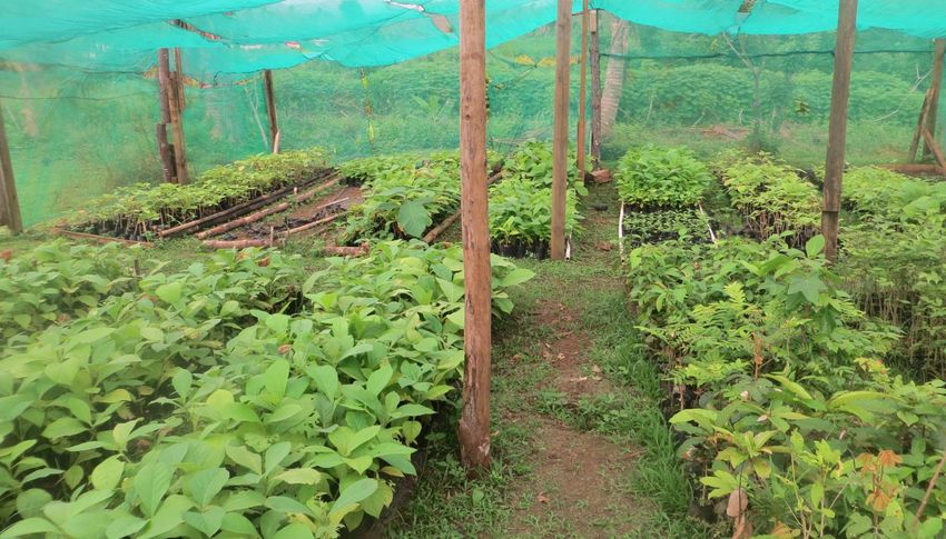
Front page photo: Tree nursery used to restore TC Winston damages, Ra Province (R.Billé, 2016)
2
TABLE OF CONTENT

1.      Introduction ........................................................................................................................... 5
2.     Land degradation and deforestation ...................................................................................... 7
       2.1       Extreme weather events: droughts and flooding......................................................... 7
       2.2       Burning and Grassland fire ........................................................................................... 8
       2.3       Agricultural practices and excessive use of fertilizers .................................................. 9
       2.4       Mangroves Degradation/Clearing ................................................................................ 9
       2.5       Development activities & threats to ecological integrity ............................................. 9
3.     Ecological restoration, conservation, and reforestation interventions................................ 10
       3.1       Riparian Buffer Restoration ........................................................................................ 10
       3.2       Mangrove Protection.................................................................................................. 11
       3.3       Reforestation .............................................................................................................. 12
       3.4       Erosion control ........................................................................................................... 16
4.      Existing policies .................................................................................................................... 16
5      Opportunities for RESCCUE implementation........................................................................ 18
6.     Potential Threats for RESCCUE implementation .................................................................. 18
       6.1       Lack of community support for the project ............................................................... 18
       6.2       Lack of knowledge ...................................................................................................... 19
       6.3       Limited community capacity ...................................................................................... 19
       6.4       Lack of collective community ownership of the project ............................................ 19
7.     Action plan ............................................................................................................................ 19
       7.1        Selection of Pilot Area ............................................................................................... 19
       7.2        Community Engagement and Awareness.................................................................. 20
       7.3        Ecological Restoration and Erosion Control .............................................................. 21
       7.4       Mangrove Replanting ................................................................................................. 22
       7.5       Timeline and indicative budget .................................................................................. 22
References .................................................................................................................................... 23
Appendix 1 – Action Plan Matrix .................................................................................................. 25
Appendix 2 – Species of Conservation Concern (IUCN and CITES) ............................................... 26

                                                                        3
Table 1: Summary of species found in Nakauvadra and Nakorotubu Range. ................................ 6
Table 2: Mangrove Seedlings planted through CTI project .......................................................... 12
Table 3: Survival assessment of planted trees in the Nakauvadra Community Based Reforestation
Project ........................................................................................................................................... 15
Figure 1 Map of Pilot Site in Ra ..................................................................................................... 20
41. Introduction
Background information
The Province of Ra is located at the northern tip of Viti Levu and is one of eight provinces found
on the main island, with a total land area of approximately 1,341 square kilometers. The 2007
national census estimates that Ra province has a population of 29,464 (Fiji Bureau of Statistics,
2007) with the majority consisting of Indigenous Fijians, followed by Fijians of Indian descent,
dispersed across 19 districts and 93 villages.
Ra Province uniquely supports two mountain ranges Nakauvadra and Nakorotubu surrounded by
large tracks of grass lands. The mountain ranges are home to a number of endangered and
critically endangered species discovered in a 2008 Rapid Biodiversity Assessment (RAP) lead by
Conservation International (CI) and the University of the South Pacific (USP). Nakauvadra
encompasses a land area of 11,387 ha and elevation ranging from 300-866 meters; Nakorotubu
encompasses a land area of 19,701 ha and elevation ranging from 100-560 meters. The Province
of Ra lies on the drier side of the island, receiving an estimated 2,000-3,200 mm of annual rainfall,
roughly half the amount of the southern side of the island (Raj, 1993). Across Fiji, climate
projections suggest that weather patterns will become more extreme in the coming years, with
increases in rainfall in the wet season and decreases in the dry season. In Ra Province, these
weather changes will aggravate an already sensitive farming and agriculture system which
provides livelihood and subsistence for local communities.
In Ra, communities are decidedly more vulnerable to the impacts of natural disasters and
weather variances due to the lack of widespread economic development. A 2011 World Bank
Report found that Ra Province is one of the most economically depressed areas in the country
with an estimated 50% of its population falling beneath the poverty line – the third highest
incidence of poverty among the country’s 14 provinces. Intervention is critical to guide
communities in sustainable economic development that integrates conservation and
management of natural resources, as well as ecosystem-based adaptation approaches to climate
change that bolster community resilience and enhance livelihoods.
Ecological significance
The vegetation of western Viti Levu is dominated by talasiga grasslands – meaning “sun burnt
land” in Fijian—which refers to the fire-modified or fire-degraded grasslands and fern-lands
found on the lower fringes and are depauperate of native flora and fauna. Talasiga grasslands
cover much of the dry side of the larger Fijian islands (Parham 1972, Smith 1979). Adverse
impacts of slash and burn agriculture and frequent fires, many of which are deliberately lit
(Drysdale, 2013), have prevented the successful re-establishment of native tree species across
the western district. Talasiga covers about a third of the area of the two main Fijian islands, Viti
Levu and Vanua Levu, mostly in the poorer, eroded areas of the western dry zone.
The remaining intact forests in the western side are located in three large forest patches: the
Koroyanitu Range in the Ba Province, and the Nakauvadra and Nakorotubu Ranges in Ra Province,
5comprising of lowland rainforest, upland rainforest and cloud forest (Mueller-Dombois and
Fosberg, 1998). The 2008 RAP assessment of Nakauvadra and Nakorotubu Range provided a
baseline for future conservation work in the areas (Morrison and Nawadra, 2009, 2010).
Significant biodiversity was observed in Nakauvadra and Nakorotubu Ranges resulting in their
designation as Key Biodiversity Areas (KBA) and proposed as National Priority Sites for
Conservation in both sites. The RAP was the first of its kind in the Province and the objectives
were to:
• collect baseline data on the diversity and conservation significance of major
terrestrial flora and fauna taxa;
• identify potential threats to biodiversity in the area, and propose mitigation
strategies to enhance biodiversity conservation;
• increase local capacity by providing hands-on training in field biodiversity inventory
techniques for students, local guides and local government researchers;
• make RAP data available for conservation management decision makers in
Government, local communities, NGOs, academia and the general public.
A summary of the flora and fauna documented from both RAP surveys can be found in Table 1
below. The highlights of the survey were the discovery of endangered and critically endangered
species including the Fijian Ground Frog (Platymantis vitianus), currently listed as Endangered,
which was found in the Nakauvadra Range and was previously thought to have been extirpated
from Viti Levu. Another significant discovery was the sighting of the endemic Podocarp species
(Acmopyle sahniana), a Critically Endangered species, in the Nakorotubu Range. Other globally
threatened species found included two rare endemic stick insects (Nisyrus spinulosus and
Phasmotaenia inermis), the Fiji long-legged warbler (Trichocichla rufa), the Black-faced shrikebill
(Clytorhynchus nigrogularis) and the Friendly ground dove (Gallicolumba stairii). A list of all IUCN
and CITES listed species can be found in Appendix 2.
Table 1: Summary of species found in Nakauvadra and Nakorotubu Range.
Taxa Total number of Total number of
species for species for
Nakorotubu Nakauvadra
Plants 425 418
Herpetofauna 10 11
Birds 38 34
Bats/Mammals 3 9
Terrestrial gastropods/macro invertebrates 22 5
6Freshwater crustaceans 12 35
Damselflies and dragonflies 31
Freshwater fish 15 8
Total 556 520
As a result of the Nakauvadra and Nakorotubu RAP surveys, several recommendations were
made (Morrison and Nawadra, 2009, 2010). Two of the key recommendations are as follows:
i. Protection of important habitats
The Nakauvadra and Nakorotubu Ranges remain relatively intact and are two of the large
remaining forest tracts in the western side of Viti Levu. It is critical to ensure protection of these
two remaining forest patches by working with stakeholders in the public and private sectors.
Apart from formal protection of the forest systems, rehabilitation should also be undertaken
along the fringes and water catchments areas that are devastated by fire, clearing for agriculture
and grazing by animals.
ii. Community awareness and education
Since a majority of the remaining intact forests are owned by Indigenous Fijians, engagement
with communal landowners is crucial to secure the success of future conservation initiatives.
Community awareness raising and education campaigns coupled with integrated training on
sustainable land use and coastal management practice, will be critical to both reduce community
activities that negatively impact the environment and simultaneously develop practical
alternatives and solutions.
2. Land degradation and deforestation
2.1 Extreme weather events: droughts and flooding
The area is already prone to droughts which are exacerbated by seasonal El Nino weather
pattern. Since 1989, a series of droughts have significantly impacted Ra, the most extreme of
which occurred in 1992, 1997-98, 2003 and 2010. The 2010 event lasted 16 months resulting in
water rationing and dispersal of emergency water supplies to many communities. At present, the
region is experiencing a drought of similar impact which began in May 2015. These droughts
impact subsistence and commercial farming as well as survival rates of livestock as food stocks
becomes increasingly depleted.
Tropical Cyclone Winston the strongest tropical cyclone ever recorded in the Southern
Hemisphere devastated huge areas of vegetation and coral reef in the Ra Province. Post-cyclone
assessment is currently underway.
7Across the Province, sugarcane crop yield is also diminished from seasonal droughts, decreasing
production of the Penang Sugar Mill, one of four sugar mills operated by the national Fiji Sugar
Corporation. Communities in the area are dependent on the sugar industry either through
farming or employment opportunities during harvest season. These seasonal droughts cause
economic shocks to local populations who have few alternative avenues for income generation
and livelihoods.
Flooding is another extreme weather event that greatly impacts the Province and affects
livelihoods and wellbeing of communities, which is usually associated with tropical depressions
and cyclones. Flooding in the area has been further exacerbated by reduced vegetation on the
catchment and gravel extraction which increases stream-flow during extreme rainfall events.
2.2 Burning and Grassland fire
Deliberate and uncontrolled burning is a rampant problem in Ra, especially during the dry season
and on sugarcane plantations. As previously noted, the majority of the land consists of talasiga
grassland that is continuously exposed to fires, thus decreasing surrounding soil quality and
increasing difficulties associated with management of exotic species. Expanded grass land
increases the threat of the encroachment of exotic species into the higher elevation pristine areas
of the Nakauvadra and Nakorotubu range. A study of the water and nutrient dynamics of pine
forest on former grass land soils in south west Viti Levu (Waterloo 1994) concluded that fires
should not be used between pine crop rotation as subsequent crop yield will decline significantly.
This decline is attributed to massive surge in nutrients released to streams with the first rain after
the burn-off. Pine forests are harvested on a 20-24 year cycle while sugarcane fields are
harvested annually.
Historically, grassland fires in the project zone have occurred on an annual basis, largely due to
pig hunting, careless behavior, and stray fires from sugarcane burning. In 2014 a total area of
169 ha was destroyed by fire compared to 19 ha in 2011 and 2013. This was due mainly to the
extreme dry conditions. Apart from replanting the burnt forestry plots, the project applied
several fire prevention measures. Trees were planted in mixed arrangements to help contain
fires. Fire breaks have been established around the reforestation sites following guidelines
developed by Fiji Pine. In the fire breaks, fire-retardant plants such as pineapples, coconuts and
citrus trees have been planted. Planting fruit crops in the firebreaks means that communities will
take a more active interest in monitoring for fires near the reforestation sites, whilst also
providing additional food security and income generation. In years that are particularly dry,
community fire wardens have also been trained and hired to patrol the project areas on a daily
basis and to report any fire instances directly to the CI Field Office and the Rakiraki Fire Authority.
Fire wardens lodge quarterly reports to the Conservation Officer in the Provincial Council for
presentation at Tikina and Provincial Council meetings.
Annual fire prevention and educational campaigns at village and tikina meetings have been held
in partnership with the District Committee and Methodist Church, which is an important
institution in the project zone. The National Fire Authority and the Rakiraki Police Department
are also invited to attend such meetings to inform communities on the legal implications of
starting fires in accordance with the 2009 Crimes Decree (arson clause).
82.3 Agricultural practices and excessive use of fertilizers
Unsustainable farming practices are defined to include logging on slopes, lack of soil conservation
practices on marginal slopes and riverbanks, extent of commercial cultivation to river banks,
overuse of chemicals among farmers and slash and burn cultivation methods. The Ra ICM Plan
further identified the prevalence of unsustainable farming in six out of the nine ICM sites in Ra
(USP, 2015).
Farmers have responded to the loss of soil nutrients and reduced soil quality by increasing the
rate of fertilizer applied every year. Loss of organic matter, increased soil compaction and soil
acidification have been experienced by farmers. Together with private sector investment, Fiji
Government has provided local sugarcane farmers with access to blended fertilizers, but this has
been met with contention and complaints regarding unsustainably high prices. Increasing prices
has also led to decreased ability to apply fertilizers to cane fields and lower cane yields.
2.4 Mangroves Degradation/Clearing
Mangrove resources in the Ra Province are limited to major rivers and creeks. Three different
types of mangrove stands have been observed in the Ra Province, delta mangroves, lagoonal
mangroves and stunted mangroves. Largescale mangrove clearing is not evident in the Ra
Province but localized mangrove harvesting for firewood still occurs.
2.5 Development activities & threats to ecological integrity
In 2015, Ra Province was declared part of the Tax Free Zone where investors can launch project
implementation within 18 months of approval. Black Sand mining in the province of Ra is in an
exploration phase and Tengy Cement, a mining company, is awaiting confirmation for a special
prospecting license for Navitilevu Bay. The communities that would be affected are discussing
establishment and declaration of a Marine Reserve in the Area (USP, 2015) with high likelihood
of opposing mining development.
Another development activity that has the potential to impact the ecological integrity is gravel
extraction along freshwater systems in Ra. In 2014, the Department of Lands did not issue any
licenses for gravel extraction; and the iTaukei Land Trust Board North/Western Office in Ra
claimed they would not issue access rights for gravel extraction. Regardless, the Ra Integrated
Coastal Management Committee recorded numerous reports from community members of
gravel extraction particularly Saivou district in Ra. Following this discovery, there was extensive
deliberation on the issue of illegal gravel extraction, and all such activities have been stopped in
the Province of Ra. The only legal gravel extraction currently being undertaken is in the district
of Naiyalayala by the Dayals Quarries Limited of Ba.
The Provincial Administrator Ra announced at the RESCCUE project inception workshop that a
major supplier of river gravel in Fiji has secured approval to source material from Ra. In return,
the Province will receive $5 million for development funds. Although this information has not
been substantiated, it must be taken into consideration when developing trade-offs scenarios
and models for payment of ecosystem services.
9With many farms left idle after the expiration of leases, the Government of Fiji is encouraging
indigenous landowners and interested individuals to fully utilize such lands in order to boost
sugar production. However, many landowners are ill equipped to till the land . In addition, such
lands are often located on medium to steep slopes, usually at a distance from the mill and are
susceptible to massive erosion, nutrient loss over time and low yield. These factors, coupled with
high transportation costs, render the farming activity in this area uneconomical. Special
attention is required to improve the productive capacity of such idle lands. Failure to advocate
sustainable farming practices that will return soil nutrient and build organic matter over time
may be detrimental to ecological integrity of many idle agriculture lands in rural areas of the
Province of Ra.
While the tax free incentive has the potential to attract many investors to the Province of Ra, this
investment must be sustainable. Adequate environmental and risk assessments must be
conducted to ensure that investment activities do not permanently damage the environment.
While economic development is critical to benefit the local population, proper procedures and
due diligence are necessary to ensure that the ecological integrity of the natural environment is
not compromised for short term gains.
3. Ecological restoration, conservation, and reforestation interventions
3.1 Riparian Buffer Restoration
Very little work has been undertaken in Ra Province in regards to riparian buffer restoration. The
most recent work was implemented in 2010 under the Coastal and Watershed Restoration for
the Integrity of Island Communities project (COWRIE), funded by Coral Reef Initiatives for the
Pacific (CRISP) and administered by CI and USP. The main objective of the project was to
empower communities in Fiji to undertake management decisions towards the restoration and
protection of their watersheds with specific links to coral reef management. The restoration
component of the project was undertaken in the District of Naroko comprising of three villages:
Rewasa, Narara, Vatukacevaceva The work involved restoring 30 hectares of talasiga grassland
and small water catchments using native and exotic species (USP & Fiji Department of Forests,
2010). Although the project was small, it provided valuable lessons including:
the need to include and incentivize community members to participate in the restoration
program;
constant maintenance of the seedlings in the nursery to be out-planted to ensure high
survival rates in the field;
maintaining community engagement through regular awareness activities especially fire
awareness and other critical issues;
collaboration is crucial especially working with communities, provincial councils and
relevant government agencies such as Department of Forests.
Another project which explored cost-benefit assessment of riparian buffer restoration was
implemented in 2012 by Landcare Research New Zealand and USP, under the Climate
Development and Knowledge Networks (CDKN) Project. The project worked in the Penang and
10Ba River catchments to assess the biophysical and socioeconomic impacts of flooding, a cost-
benefit assessment of management options, and the potential impacts of climate change on
communities. The aim of the study was to provide information for proactive management
through infrastructure development, social solutions, and/or ecosystem-based adaptation to
mitigate the risks posed by extreme weather associated with climate change.
The study indicated upland restoration and repair of the riparian buffer zone offered the best
cost benefit scenario for communities in Ba and Penang. The cost benefit analysis indicated that
the Net Present Value (assuming project life of 100 years and discount rate of 8%) of upland
afforestation provides the highest net benefit. While it is acknowledged that planting along
streams and riverbanks does not provide the highest level of protection from flooding, the low
cost of implementation coupled with the provision of ecosystem services (such as carbon
sequestration, provision of non-timber forest products, and habitat provision) indicates that
riparian planting has the highest impact per dollar spent on mitigation. This assessment analyzed
the cost-benefit value and efficacy of restoring the riparian buffer zone in current, moderate, and
severe climate change scenarios – riparian buffers remained the best option for all three
constructs.
Simply put, riparian buffers are cost effective and most efficient mitigation options. Other
mitigation options compared in the cost benefit analysis included other ecosystem based
approaches (EbA) such as planting floodplain vegetation, reinforcing river banks; and hard
approaches such as raising houses, dredging rivers and mixed intervention. The study also noted
that mixed intervention incorporating both hard and EbA is effective under most scenarios and
may be preferable to many approaches. However, the cost of hard approaches can be high, and
hence the efficiency of mixed interventions is lower than that of some EbA by themselves.
3.2 Mangrove Protection
In Ra, the majority of the mangrove protection and rehabilitation interventions have been carried
out at the community level with assistance from the Fiji Locally Managed Marine Area Network
(FLMMA). Another organization with a long history of mangrove protection in Ra is the
Organization for Industrial, Spiritual and Cultural Advancement International (OISCA). In 2012,
OISCA replanted a total of 10,000 mangrove seedlings on 3 hectares of the Nakorotubu coast,
located within the 10 marine protected areas in 8 villages (OISCA, 2013). A mangrove nursery
was also constructed in Saioko Village in Nakorotubu District to supply seedlings for replanting.
In 2015 as part of the Coral Triangle Initiative (CTI) funded by the Asian Development Bank, five
coastal villages in Ra undertook mangrove replanting: Navolau, Togovere, Vitawa, Narewa, and
Naivuvuni. Approximately 19,000 mangrove seedlings were planted across an estimated 17 ha.
of coastal shoreline. The objectives of the mangrove replanting exercise were to educate and
encourage mangrove replanting by communities to safeguard and stabilize the coastline.
11Table 2: Mangrove Seedlings planted through CTI project
Village No. Seedlings Planted Equivalent Area (3x3m spacing between trees)
Navolau 3,081 2.8Ha
Togovere 3,369 3.0Ha
Vitawa 6,780 6.1Ha
Narewa 2,700 2.4Ha
Naivuvuni 3,369 3.0Ha
TOTAL 19,299 17.3Ha
3.3 Reforestation
SPC Reforest Fiji programme
The Pacific Community (SPC) is currently implementing a €9 million (F$20 million) forestry project
initiative funded by the European Union. The objective of this reforestation project is to have
about 7.5 million trees planted covering 6000 hectares of forestry plantations and woodlots in a
major boost for livelihoods in Viti Levu. The forestry project will provide important long-term
environmental and economic benefits for Fiji. Reforest Fiji will involve communities in areas
highly susceptible to soil erosion such as Koronubu, Drasa and Malolo. It is envisaged that trees
planted under the Reforest Fiji programme, will contribute in generating an estimated 400,000
days of employment. One of the expected outcomes of this forestry initiative is to mitigate the
impact of soil erosion sugar cane belt areas. One of the project demonstration sites in Vuniyasi,
Malolo, Nadi, in Western Viti Levu. Reforest Fiji is a pilot project that will conclude in June 2018.
Fiji Pine Limited (FPL)
The best known reforestation work undertaken in Fiji is the afforestation of large tracts of talasiga
grasslands by FPL with Pinus caribaea on land leased from indigenous landowners. Pine
plantations were established in Fiji from the 1950’s through loans from large donor agencies such
as the Commonwealth Development Cooperation supported by the UK, Australia and New
Zealand Government (Whyte, 1998). The afforestation activity was and is still carried out on land
communally owned by Indigenous Fijians. In 1999 FPL had approximately 77,680ha with just over
40,000 fully stocked P. caribaea; 9000 ha idle land; 14,000 non stocked whilst the rest are either
in reserve, trial or under research (Oliver, 1999). The main objective of the large scale pine
afforestation activity is to:
Broaden the economic base by providing forest based industry based on pine
plantations;
Provide more than 10,000 rural based community members with economic
opportunities for work;
Generate foreign exchange earnings through export of pine chips;
12 Protect and conserve the environment1 through planting activities on degraded
talasiga grasslands that are susceptible to wind/water erosion and wild fires.
Pine plantation estate in the Ra Province is estimated at 2,890ha of fully stocked P. caribaea
which is equivalent to 4% of the total pine estate in Fiji (Oliver, 1999). There are many small pine
woodlots in communal and private lands in Ra Province. Pine woodlots range in size from 25ha
to 100ha. These were planted through the Fiji Pine Extension Program of the Department of
Forest and were aimed at establishing privately owned pine plantations among rural
communities to generate economic returns and supplement Fiji Pine Limited wood resources
(Von Maybel, 1998).
The primary objective of FPL is the socio-economic development of rural areas and the alleviation
of poverty through stimulation of the rural economy; the establishment of plantation-related
business ventures; creation of employment opportunities; and support for education and training
of the rural people, particularly for the landowners that the FPL leases land from. Pine forest
landowners and local communities benefit from FPL activities through lease payment (F$12 per
hectare), a log stumpage share (12 percent of net log sales), and contracts for all field operations
( 14 million FJD per year) (Sue, 2010).
Across Fiji, the primary threat to pine plantations is fire. On average, FPL puts out around 150
plantation fires per year and an estimated 50 wild fires. FPL also conducts around 1,000
controlled burns each year (Van Duesen, 2008). In 1997, around $1million worth of pine
plantations were written off due to fire, and between 1987 and 1997 a total of 8,566 ha of pine
plantations were written off due to fires (Were, 1997). The main cause of fire is arson arising out
of conflict between FPL and the landowners, employment issues, low rate of returns, social equity
issues and politics (Were 1997; Van Duesen, 2008). Other major source of fire comes from
escaped agricultural fires from the sugarcane belt; followed by grazing; negligence and lighting
(Drysdale, 2013).
Future Forests Fiji (FFF)
Future Forest Fiji was established in 2005 by a group of local and overseas investors mainly to
specialize in growing teak (Tectona grandis) for timber production and export. At the end of 2012
a total of 200 ha were planted (Future Forest Fiji, 2012). As of 2014, the company owns 239 ha
of teak plantation under pre-commercial stages with the oldest planted in 2006 and an estimated
60% ranging from 2 to 5 years old (Future Forest, 2015). A majority of the teak plantations are
located in Ra and the rest in the Nadroga Province.
Nakauvadra Forest Carbon Project
The Nakauvadra Community Based Reforestation Project in Fiji was developed by CI, and funded
through the support of FIJI Water Foundation. The project is located on the northern tip of Viti
Levu in the Province of Ra and comprises 1,135 ha of reforestation plots along the Southern and
Northern slopes of the Nakauvadra Range. The project commenced in October, 2009 with an
initial 100 ha of mixed species (teak-Tectona grandis and mahogany-Swietenia macrophylla)
1
Pinus caribaea is not considered as an invasive species in Fiji.
13spread over five plots. The project’s main objective is to develop a multiple benefit, community
based reforestation project that:
reforests an area of 1,135 ha which results in the sequestration of an estimated 280,000
tCO2 over the 30 year project lifespan, validated and verified to the Climate, Community
and Biodiversity Standards (CCBS). So far carbon credits have been sold;
increases forest cover around the Nakauvadra Range to expand critical habitat for
endangered and endemic species while enhancing forest connectivity with other adjacent
forest blocks; and
enables local communities and landowners to benefit from job creation, increased
revenue, and the enhancement of livelihoods in both the short and long term.
The project incorporates a community-based reforestation model, planting hardwood timber
species on 28% of the total area which can be sustainably harvested upon reaching maturity to
provide for long term income generation for the landowning communities. The remaining 72%
of the project site was reforested using native and endemic species, especially on the steeper
slopes of the Nakauvadra Range which will expand forest habitat and create a ‘green wall’ around
the more pristine upland and cloud forest ecosystems that are found in the rugged and higher
elevation areas of the Range. The reforestation sites have been strategically identified to ensure
the creation of new forest patches that are envisaged in the long term to help establish a
conservation corridor between the Nakauvadra Range and nearby Wabu/Tomaniivi Range, 4kms
on the southwestern flanks of Nakauvadra.
The project reforestation sites are all on native land owned by different landowning units
(mataqali). Community Conservation Agreements (CCA) have been signed with each landowning
unit. The CCA provides guidance and understanding on the roles and responsibilities of each party
during the project lifetime. According to the agreement, each mataqali gives full consent to CI to
carry out the reforestation project on their behalf and allows project staff to access their land for
such purposes. The CCAs further stipulate that the mataqali will maintain the planted trees for
30 years after which the forest stock will become part of the mataqali asset.
Survival rates indicated that the exotic teak (Tectona grandis) is very successful especially in the
talasiga grassland. It is noted that as teak was gradually phased out and replaced by native
species; survival rates decreased from about 94% in 2009 to 27% in 2014. The low survival rates
are attributed to the long droughts in 2014 and 2015 in addition to wild fires.
14Table 3: Survival assessment of planted trees in the Nakauvadra Community Based Reforestation Project
Average Survival Rates Planting Ratio (%)
(%)
Year Native Exotic
2009 94 20 80
2010 72 50 50
2011 61 50 50
2012 57 50 50
2013 28 100
2014 27 100
Reforestation of Degraded Areas
Fiji has benefited from a number of reforestation campaigns in and projects in recent years. In
2010, the Fiji Government launched the “Our Gift to the Future Generation” campaign. At the
end of the year-long campaign, over 1,010,000 trees were planted. The campaign was extended
to support the United Nations International Year of the Forest in 2011, after which the total
number of trees planted increased to 1,722,0002. Under the Nakauvadra Community Based
Reforestation Project, CI facilitated capacity building among communities to identify tree species,
collect seeds, build low cost nurseries, germinate and tend to tree seedlings. As a result, the
communities were able to raise and sell tree seedlings to the project; generating new sources of
revenue to improve local livelihoods (Conservation International, 2013).
In 2015, the central government launched the Reforestation of Degraded Forest project, which
supported rehabilitation of an estimated 150 ha of degraded forest was rehabilitated across Fiji,
mostly on Viti Levu. This was implemented through Fiji Department of Forest (DoF)-Extension
Division, and as the name suggests, funded rehabilitation of degraded forest using combination
of native and exotic species mainly pine (Pinus carribea) and mahogany (Swietenia macrophylla)
depending on condition of site. Villages interested in participating under the project apply
directly to the Conservator of Forests, after which a team is dispatched to assess the area and
suitability for selection. DoF then supplies seedlings and technical expertise to carry out the
reforestation program. Several villages in the Ra Province were selected in 2015 including
Wailevu, Naivuvuni, Nanukuloa and Matawailevu village. The project continued this year (2016)
with funding of 500,000FJD targeting an area of 500 hectares for reforestation.
2
http://www.wwfpacific.org/?200219/1-million-trees-in-support-of-International-Year-of-Forest
153.4 Erosion control
Soil erosion
There has been little academic research to assess the severity and breadth of erosion control
across Ra. Since the onset of sugarcane cultivation in the late 1880’s soil erosion and erosion
control have posed a challenge to sustainable land management, particularly in Fiji’s western
districts (Drysdale 2013). Increases in agricultural production over the last 30-50 years and lack
of sustainable land management practices have exacerbated erosion. Vetiver Grass was
introduced as a viable solution in the early 1950’s, planted in hedgerows along steep slopes to
secure soil (Truong 1994). Erosion has become exacerbated by the shift to production of short
term crops, such as taro, cassava, ginger and kava, to increase earnings from exportation of
agricultural products (Nakalevu et al. 1998).
In view of the limited arable lands in Fiji (Leslie et al. 2002), increasing population (Fiji Island
Bureau of Statistics 2008) and development programs, it is imperative that sustainable land
management be practiced to ensure continuity and sustainability of food production. In addition
to the use of Vetiver Grass, other initiatives have emerged using agroforestry models using
Caliandra trees, mechanically modified slopes and mulching (Ratukalou et al.1999). The choice
to decide which erosion control measures to use mainly depends on the type of crops,
assessment of land aspect such as slope angle, soil type, weather pattern and land tenure.
Lessons learnt from demonstration activities in Fiji and Vanuatu were documented in a series of
four manuals developed under the COWRIE project, aimed to assist communities in ridge to reef
watershed management. The manuals covered: (1) watershed management, (2) guide to planting
local trees for restoration (3), guide to building a low cost community nursery and (4) use of
vetiver Grass in degraded Areas (USP, 2011). These manuals provide best-practice guidelines for
watershed management through experiences of ridge to reef landscape planning with
communities from the Province of Ra.
4. Existing policies
The People’s Charter, 2010–2014 Roadmap (Ministry of National Planning 2009), the Constitution
of the Republic of Fiji (2013) and the Green Growth Framework for Fiji (Ministry of Strategic
Planning, National Development and Statistics 2014); provides the enabling environment for
sustainable development at national scale. These policies encourage sectorial integration and
proclaim that sustainable development will be achieved through democracy, fair governance,
inclusive development, national unity, and more importantly a healthy natural environment.
From a sectorial perspective, key policies that will impact ecological restoration and erosion
control in Ra Province include the Ministry of Fisheries and Forest, Rural Land Use Policy, and
Climate Change.
The Forest Policy Statement (2007) reflects the multiple uses and purposes of forest
management that have evolved over the years, to increase the environmental, social and
economic opportunities of the forest sector. It provides a paradigm shift from timber production
16to sustainable multiple-use management regime. This includes sustainable forest management,
conservation, and the use of forests as carbon sinks. The policy recognizes the economic
potential of the sector as a major source of foreign exchange and aims to develop the sector in a
way to ensure this is maintained. It also promotes conservation, rehabilitation and sustainable
forest management in line with the Rural Land Use Policy for Fiji and stresses the social role of
forestry in creating a sustainable rural environment, employment and income opportunities. It
recognizes the need to engage and involve local stakeholders and landowners in the sustainable
management, protection, and rehabilitation of resources.
The Rural Land Use Policy for Fiji (Leslie et al. 2006) argues that there is a need to establish long
term land use plans to guide farmers on the most appropriate crops suitable to different
ecological geographies in Fiji. The vision of the rural Land Use Policy is to protect ecological
systems and biodiversity; reduce damage to fragile ecosystem; improve rural environmental
conditions; promote sustainable farming and encourage establishment of Land Husbandry
Groups.
The National Climate Change Policy (2012) and the National Climate Change Adaptation Strategy
(Government of Fiji 2011) have synergies with the Green Growth Framework (2015) but focuses
on forestry, agriculture, water, livestock, biodiversity and natural ecosystems through the lenses
of Climate Change Adaptation. It aspires to identify and implement efficient and effective
activities to manage the existing and anticipated consequences of climate change. With
increasing opportunities created through the introduction of the United Nations Reducing
Emissions from Deforestation and Forest Degradation (REDD) program, the Department of
Forestry has developed a National REDD+ Policy for Fiji (2011).
Despite strong policy frameworks, implementation of policy programs remains a challenge. In
addition, supporting legislations to enforce policies are either non-existent or not implemented
by line agencies. Current legislations pertaining to fire can be found in various legislations such
as the 1985 Land Conservation and Improvement Act which basically covers construction and
maintenance of fires breaks and the role and responsibilities of fire rangers. The 2009 Crimes
Decree (arson clause) has stricter punishments for burning forestry plots. However, enforcement
has been difficult for various reasons such as lack of initiative by community leaders in reporting
offenders or offenders seeking traditional reconciliation ceremony and lack of manpower or
initiative by local police to investigate and prosecute.
The proposed RESCCUE ecological restoration/conservation activities will endeavor to implement
core principles of the all the policies outlined above in a simple and practical way in order to
demonstrate that communities can be guides to make informed decision to better management
available resources through sound infrastructure development, social solutions, and/or
ecosystem-based adaptation that mitigate ecological loss in a cost effective manner. As such,
RESCCUE activities represent potential opportunities to increase the effectiveness of these
existing policies.
175 Opportunities for RESCCUE implementation
Stakeholders working in the Province of Ra have set the platform to apply a ridge to reef
landscape planning framework through various projects including ongoing efforts to protect the
Nakauvdra and Nakorotubu Range, the Nakauvadra Reforestation Project at the fringes of the
two mountain ranges and the COWRIE project dealing with watershed management. In addition,
the CTI/ADB project provided the link between land-based initiatives and the marine
environment providing the necessary foundation of establishing clear and strong Governance
structures to support the development of the Ra Integrated Coastal Management Plan (Ra ICMP).
The Ra ICMP was endorsed by the Provincial Office in Ra as well as the National Integrated Coastal
Management Committee in 2015. The Ra ICMP highlighted eight priority coastal resource issues
ranging from gravel extraction, burning, pouching in marine areas, use of destructive fishing
methods, waste water management, sustainable financing mechanism for coastal/marine areas,
black sand extraction and unsustainable farming practices (USP, 2015).
6. Potential Threats for RESCCUE implementation
Lessons learnt from past experiences in the Province of Ra have indicated the need to include
and incentivize community members to participate in all aspects of project implementation.
Incentives will be limited to the supply of raw materials used in the demonstration sites. We
have also learnt that we need to constantly engage with communities to maintain the level of
awareness necessary to drive voluntary community participation. Project staff will attend village
meetings, Tikina meetings and where necessary, Provincial meeting. Project staff will also
collaborate with working committees set up by the Provincial Office or the Provincial
Administrator and other stakeholders to secure support for the project.
6.1 Lack of community support for the project
Since most people prioritize short term benefits, the inadequate provision of benefits in the
longer term could lead to the loss of support or abandonment of the project by communities.
The project has secured community agreements with all the landowning units involved in the
project which outlines the responsibilities and benefits to be accrued by each partner. In addition,
the project has been designed so that immediate financial benefits accrue to participating
communities in the first five years through the reforestation and maintenance activities. In
addition, revenue may be accrued by the community during the harvest of hardwood species
upon reaching maturity in year 20. To complement this in the short and medium term, livelihood
diversification activities are carried out across the project area, engaging with communities at
village level and focusing on income generation through the provision of materials to set up
microeconomic enterprises such as honey (provision of beehives), ginger, pandanus leaves,
pineapple, coconut and other fruit trees, and sandalwood. It is expected that these initiatives will
become financially sustainable in the long term, and leverage the replication of similar
enterprises in other neighboring villages.
186.2 Lack of knowledge
The lack of knowledge and understanding about the long-term direct and indirect benefits could
lead to non-cooperation among community members. The communities will need to understand
the benefits of increasing forest cover and the associated long term impacts on the continued
provision of key ecosystem services. Clear and direct communication with community members
presenting the project benefits and addressing any potential challenges will be an on-going
process. To promote the active participation of communities for the long term maintenance and
protection of the reforestation sties, information, capacity building and awareness raising
activities will be undertaken. Key messages to be conveyed include (1) well maintained forests
can provide improved watershed protection; (2) contribute to clean water in the creeks
emanating from the Range and (3) contribute to enhancing livelihoods through the provision of
forest products (fruits and seeds) and river food. Such benefits will be beneficial to their own
families and clan members as direct beneficiaries.
6.3 Limited community capacity
The communities involved in the project at the outset have limited capacity to undertake the
reforestation and ongoing maintenance and fire prevention activities to ensure the long term
success of the project. Conservation International has provided training and capacity building to
each community involved in the project on all the reforestation activities including seedling
collection, nursery establishment, planting and maintenance. These skills will allow communities
to set up their own independent nurseries. The nurseries may support the collection and sale of
sandalwood seedlings which are highly sought after in the local area. In addition, the Department
of Forests, a key partner to the project is working with CI to offer long term support, such as the
provision of training on the sustainable harvesting of the teak, and the incorporation of
community nurseries into their own annual program for capacity building delivery.
6.4 Lack of collective community ownership of the project
The reforestation sites are owned by different mataqali but not all members of any given
community are landowners or involved in the reforestation agreements, which could cause
resentment and division in the community as well as generating a lack of ownership for the
project within the whole or sections of the community. The livelihood diversification activities
are strategically organized at community level regardless of landowning status to ensure that
benefits are shared among community members, thus ensuring broad support for the project.
This includes the planting of pineapple, coconut and other fruit trees as well as, the provision of
sandalwood seedlings, and the establishment of beehives and fish ponds. CI is also engaging
community members at multiple levels, including the traditional chiefs, youth and women’s
groups to ensure that all concerns, issues and voices are be heard.
7. Action plan
7.1 Selection of Pilot Area
In view of past and ongoing ecological and environmental interventions in the Province of Ra
such as the Nakauvadra Community Based Reforestation Project; the COWRIE, Coral Triangle
19Initiative, Climate Development and Knowledge Networks (CDKN) Project, the proposed action
plan will focus in the Tikina Saivou. Tikina Saivou hosts five villages of Nanukuloa, Barotu,
Naiserelagi, Tokia and Rokoroko.
Tropical Cyclone Winston which passed through Fiji on the 20 February 2016 devastated the
livelihood and natural environment of people of the Ra province and several other provinces in
Fiji. However, the action plan priorities in relation to ecological restoration activities in the
province of Ra will be reviewed given there is post-disaster needs assessment (PDNA) being
carried out in all the affected provinces in Fiji.
Tikina Saivou is located downstream from Tikina Tokaimalo and adjacent to Tikina Naroko,
Nalawa and Nabala. It is situated along the coast of the Viti Levu Bay supporting the estuarine of
the Barotu Rriver. Small holder farms are flanked on each side of the river bank from the
estuarine approximately 100km inland towards Tikina Tokaimalo.
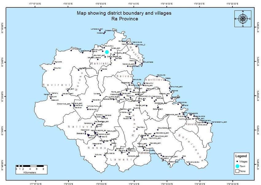
Figure 1 Map of Pilot Site in Ra
7.2 Community Engagement and Awareness
The project will undertake general awareness workshop as a form of introducing its objectives,
activities and expected outcomes to community members. The workshop will also serve as a
20forum to collate information on local species that currently grow in water catchment areas,
riparian zones and flood plains. Community mapping exercise will provide a quick overview of
the challenges in the physical environment around the community. Community discussion will
identify the problems, root causes and rank appropriate solutions to each issue. Detailed Action
Plan Matrix is outlined in Appendix I.
7.3 Ecological Restoration and Erosion Control
The most common erosion control found in Ra province is the use of Vetiver grass in the sugar
cane areas (Conservation International 2013). The Vetiver grass system is proven to be the best
for controlling erosion and reducing rainfall runoffs (Truong 1994). According to the Vetiver
Network Newsletter3, appropriate Vetiver grass system can reduce soil erosion by up to 90%. In
Fiji when used in sugar cane can increase production up to 55% (Truong 1994).
Vetiver grass and pineapple were used as hedgerows in a soil erosion research in Waibau,
Naitasiri. This was tested against ‘farmers practice’ which does not have any hedgerow barriers
along the slope. Results from 1992 – 1999 during a ginger season shows an average soil loss from
vetiver grass at 0.3 t/ha, pineapple at 3.5 t/ha while farmer practice produce 17.5 t/ha. Most
farmers in the central division adopted vetiver grass hedgerows after they were convinced by the
Fiji – German Agroforestry Project demonstration which introduced Caliandra as hedgerows
along the mid-slope and vetiver grass at the lower slope (Nakalevu et al. 1998).
Although the Nakauvadra Community Based Reforestation Project used pineapple and vetiver
grass in a few model farms; it was not effective since most farmer still practice shifting cultivation.
In addition, most farmers in Ra Province use large mechanised machines which require wider
plots. At the same time it has been observed that the use of vetiver grass has not been widely
adopted by the indigenous communities in the Ra Province but is very popular among sugar cane
tenant farmers.
The Tikina Saivou is affected by agriculture and coastal land erosion, burning, poaching,
destructive fishing methods, waste management and unsustainable farming practices. Ecological
restoration and erosion control will focus on planting fruit trees along riparian zones of the
Borotu River. The riparian planting will commence from the river mouth to approximately 100km
inland. Three rows of contour planting at 3m part will be stablished. The first row of contour
plant, next to the river bank will consist of vetiver grass. The next row will consist of deep rooted
fruit trees/medicinal such as Inorcarpus fagiferus (ivi), Dracontomelon vitiense (tarawau),
Spondias dulcis (wi) and others and the last row (furthest from the riverbank) will host
leguminous plants. The aim of the planting design is to be able to accumulate organic matter
over time. Suitable water resistant plants will be planted in the flood plains such as the Hibiscus
tiliaceus (vau), Leucaena leucocephala (vaivai) and firewood species such as Causarina
equisetifolia (nokonoko) and Causarina nodiflora (velau/cau).
Erosion pads will be installed at 50m interval on both sides of the river bank to assess the impact
of rehabilitation over time. The pads are made of steel pipes which are driven into the soil. The
3
http://www.vetiver.com/TVN_newsletter_archive.htm
21soil level will be marked on the pipe. The pipes will remain in the soil permanently with
monitoring to be done every 3 months. The village headman and youth representative will be
taught how to monitor soil erosion over time. It is suggested that the results be submitted
formally to the Conservation Officer Ra for ease of reference.
Depending on the status of the riverbank and community aspirations, riverbank reinforcing and
village drainage may also need to be considered.
7.4 Mangrove Replanting
Mangrove planting will be undertaken after a rapid assessment is made on the types of mangrove
species in place. The introduction of new species from a remote (different) area will not be
entertained. Species of trees above the high tide water mark will also be noted to inform species
selection for rehabilitation of flood plains In case of severe coastal erosion, it may be necessary
to consider using green technologies for restoring/reinforcing sea walls from beach sands.
Another aspect often overlooked involves using locally available species as indicators for
ecological systems. It is proposed incorporate such indicator with alternative livelihood.
Accordingly, the Ra Integrated Coastal Management Plan proposes the development of
ecotourism ventures in Tikina Saivou. The action plan aims to undertake specific skills training
for key individuals/youths in the village of Naiserelagi to enable them to identify sea birds. This
will be the foundation for future skills development in the area of tour guides for bird avid
birdwatchers. At the same time, these individuals/youths would be able to monitor presence
and absence of bird species over time.
7.5 Timeline and indicative budget
Objective Activity Cost April May June July August
Community
Engagement and Provincial
Awareness Community meeting Meeting $ 200.00
Tikina Meeting $ 200.00
Village Meeting $ 200.00
Community
workshop (2 Planning
communities) workshop $ 6,000.00
Riparian and flood
Ecological plain planting
Restoration and (Seeds/seedling
Erosion Control costs) $ 3,000.00
Mangrove
Replanting Mangrove planting $ 2,000.00
Establishement of
erosion
Erosion Control troughs/erosion pin $ 2,000.00
22References
1. Conservation International, 2013. Nakauvadra Forest Carbon Project. Project
Document.
2. Drysdale, P. 2013. The Real Cost of Rural Wildfires In the Western Division of Fiji. Fire
in the sugarcane crop cycle. The loss to the economy and environment. Practical
Remedies. Lautoka. Fiji. Unpublished.
3. Fiji Island Bureau of Statistics. 2008. CENSUS2007 RESULTS: POPULATION SIZE,
GROWTH, STRUCTURE AND DISTRIBUTION. 2007 Census of Population and Housing.
Statistical News. Ratu Sukuna House, Mac Arthur Street, Victoria Parade, Suva, Fiji
Islands
4. Future Forest Fiji, 2015. Future Forest Fiji Plantations: Annual Report. Future Forest
Fiji, Ra, Fiji Islands.
5. Government of Fiji. 1979. Integrated Review of Uluisaivou Beef Scheme. Unpublished.
6. Government of the Republic of Fiji. 2011. National Climate Change Adaptation
Strategy. Secretariat of the Pacific Community. Suva. Fiji.
7. Government of the Republic of Fiji. 2012. Republic of Fiji National Climate Change
Policy. Secretariat of the Pacific Community. Suva. Fiji.
8. King, T. 2001. Report on the fire situation in Fiji. International Forest Fire News 26.
9. Leslie. D. and Ratukalou. I., 2006. Rural Landuse Policy for Fiji. Secretariat of the
Pacific Community.
10. Ministry of Agriculture. 2014. Fiji 2020. Agriculture Sector Policy Agenda. Modernizing
Agriculture. Unpublished.
11. Ministry of National Planning 2009. ROADMAP FOR DEMOCRACY AND SUSTAINABLE
SOCIO-ECONOMIC DEVELOPMENT 2010-2014. A Better Fiji for all.
12. Ministry of Strategic Planning, National Development and Statistics. 2014. A Green
Growth Framework for Fiji. Restoring the Balance for Development that is sustaining
the balance for our future. Ministry of Strategic Planning, National Development &
Statistics, Republic of Fiji.
13. Morrison, C. and Nawadra, S. (ed.). 2009. A rapid biodiversity assessment of the
Nakauvadra Highlands, Ra Province, Fiji. RAP Bulletin of Biological Assessment 57.
Conservation International, Arlington, VA, USA.
14. Morrison, C., Nawadra, S., and Tuiwawa, M. (ed.). 2010. A rapid biodiversity
assessment of the Nakorotubu Range, Ra and Tailevu Provinces, Fiji. RAP Bulletin of
Biological Assessment 59. Conservation International, Arlington, VA, USA.
15. Mueller-Dombois, D. and Fosberg, F. R. 1998. Vegetation of the Tropical Pacific
Islands. Springer Press, New York.
16. Nakalevu, T., Ratukalou, I., Waradi, J., Elder, M., and Dowling, P. 1998. VETIVER AND
CASH CROP EROSION CONTROL SYSTEMS FOR SUSTAINABLE SLOPING LAND FARMING
IN FIJI. Ministry of Agriculture, Fisheries and Forest. Fiji
17. Oliver, W. W. 1999. Plantation Forestry in the South Pacific: A Compilation and
Assessment of Past and Present Practices USDA, Forest Service, Pacific Southwest
Research Station Redding, California U.S.A.
18. Parham, J. W. 1972. Plants of the Fiji Islands. Government Printer, Suva, Fiji.
23You can also read