Efficient deployment of satellite navigation systems in Finland. Action plan 2017-2020 - PUBLICATIONS 6/2018
←
→
Page content transcription
If your browser does not render page correctly, please read the page content below
PUBLICATIONS 6/2018

Efficient deployment of satellite navigation
systems in Finland. Action plan 2017-2020
Ministry of Transport and Communications

Vision
Wellbeing and competitiveness through high-quality transport and communications
networks

Mission
The Finnish Ministry of Transport and Communications seeks to promote the
wellbeing of our people and the competitiveness of our business.
Our mission is to ensure that people have access to well-functioning, safe and
reasonably priced transport and communications networks.

Values
Cooperation
Date of publication
                                                      12 April 2018
Title of publication
Efficient deployment of satellite navigation systems in Finland. Action plan 2017-
2020
Author(s)
Seija Miettinen, Senior Adviser
Seppo Öörni, Senior Adviser
Olli Lehtilä, Senior Officer
Commissioned by, date

Publication series and number
                                                      ISSN (online)
                                                      ISBN 978-952-243-550-7
Publications of the Ministry of                       URN     URN:ISBN:978-952-243-550-7
Transport and Communications                          Reference number

6/2018
Keywords
satellite navigation, positioning, location data, Galileo, GPS, small satellites, New Space
Contact person

Other information

Abstract
Along with digitalisation, satellite navigation has become an important part of our everyday life. For
example, the operation of power and communication networks and transport services requires satellite
positioning and accurate timing. The satellite navigation sector is indeed growing and, in 2017, the
European Commission estimated the value of the satellite navigation sector at over EUR 70 billion.
With the growth of automated transport and the development of 5G and IoT, the market value is
estimated to rise to about EUR 195 billion by 2025. Europe is undergoing an important phase in the
development of satellite navigation as the Initial Services of Galileo, the European Global Navigation
Satellite System (GNSS), have recently been introduced and the system is expected to be in full
operation in 2020. Over the past few decades, Finnish experts and Finnish expertise have been part
of several space and satellite projects. In addition, the first satellites of our own have been developed
over the past few years and Finland is indeed becoming a new operator in the satellite markets.

This Action plan describes the current state of satellite navigation systems and how they are deployed
in the different sectors of our society, especially in automated transport. At the same time, it describes
the current model of Finnish space administration and the pressure to reform it. At the end of the Action
plan, 17 concrete measures are proposed to promote the deployment of satellite navigation especially
at a national level. The Action plan is part of one of the key projects in Juha Sipilä’s Government
Programme: A growth environment will be created for digital business operations. The work has been
carried out by listening to a wide range of actors in the sector.

The Action plan aims to ensure that satellite navigation systems are deployed in all sectors of society
in all of Finland. Its key goals in terms of the future are the following: making Finland one of the leading
countries in the deployment of satellite systems and enhancing the preconditions for the current high
quality of space research in Finland, enhancing the deployment of satellite data in business activities
and service provision, ensuring the quality of positioning and the deployment of satellite navigation
systems in all Arctic regions, promoting the deployment of small satellites, and determining the need
and possibilities to establish a space administration in Finland.
Publikationsdatum
                                                     12.4.2018
Publikation
Effektivt utnyttjande av satellitnavigering i Finland – åtgärdsprogram 2017–2020
Författare
Seija Miettinen, ledande sakkunnig, trafikråd
Seppo Öörni, trafikråd
Olli Lehtilä, överinspektör
Tillsatt av och datum

Publikationsseriens namn och nummer
                                                     ISSN (webbpublikation)
                                                     ISBN 978-952-243-550-7
Kommunikationsministeriets                           URN   URN:ISBN:978-952-243-550-7
publikationer 6/2018                                 HARE-nummer

Ämnesord
satellitnavigering, positionering, positionsinformation, Galileo, GPS, små satelliter, New Space

Kontaktperson                                        Rapportens språk

Övriga uppgifter

Sammandrag
I och med digitaliseringen har satellitnavigering blivit en betydande del av vår vardag. Bland annat de
tjänster som betjänar elnäten, telekommunikationsnäten samt trafiken och transporterna kräver
satellitbaserad positionering och exakt tidsinformation. Marknaden för satellitnavigering växer och
Europeiska kommissionen har uppskattat att marknadens värde är över 70 miljarder euro 2017. Som
ett resultat av utvecklingen inom automatiserade transporter, 5G och IoT väntas siffran stiga till 195
miljarder euro 2025. I Europa befinner vi oss nu i ett viktigt skede i utvecklingen av satellitnavigering:
de första tjänsterna i det europeiska globala Galileo-satellitnavigeringssystemet har just tagits i bruk
och avsikten är att hela systemet ska fungera fullt ut 2020. Finländare och finländsk kompetens har
under de senaste årtiondena varit delaktiga i ett stort antal rymd- och satellitprojekt. Dessutom har man
i Finland under de senaste åren för första gången utvecklat egna satelliter och vårt land är på väg att
bli en ny aktör på satellitmarknaden.

I detta åtgärdsprogram beskrivs nuläget i fråga om satellitnavigeringssystem och utnyttjandet av dem
på olika samhällsområden i Finland, särskilt inom automatiserade transporter. Samtidigt beskrivs den
nuvarande modellen för rymdförvaltningen i Finland och det förändringstryck som riktas mot den. I
slutet av åtgärdsprogrammet presenteras 17 konkreta åtgärder för att öka utnyttjandet av
satellitnavigering särskilt på det nationella planet. Åtgärdsprogrammet är ett led i det spetsprojekt i
statsminister Juha Sipiläs regeringsprogram som siktar på att skapa en tillväxtmiljö för digital
affärsverksamhet. Programmet har beretts på bred bas i samråd med branschen.

Målet med åtgärdsprogrammet är att säkerställa att olika system för satellitnavigering utnyttjas inom
alla sektorer i hela Finland. De centrala målen med tanke på framtiden är att lyfta upp Finland till täten
bland de länder som utnyttjar satellitsystem, att stärka verksamhetsbetingelserna för den nuvarande
högklassiga inhemska rymdverksamheten, att öka utnyttjandet av satellitinformation inom
affärsverksamheten och vid tillhandahållandet av tjänster, att säkra kvaliteten på positioneringen och
utnyttjandet av satellitnavigeringssystem i arktiska regioner, att främja utnyttjandet av små satelliter
och att utreda behovet av och möjligheterna att grunda en rymdförvaltning i Finland.
Julkaisun päivämäärä
12.4.2018
Julkaisun nimi
Satelliittinavigointijärjestelmien tehokas hyödyntäminen Suomessa -
toimenpideohjelma 2017–2020
Tekijät
Seija Miettinen, johtava asiantuntija, liikenneneuvos
Seppo Öörni, liikenneneuvos
Olli Lehtilä, ylitarkastaja
Toimeksiantaja ja asettamispäivämäärä
Julkaisusarjan nimi ja numero
ISSN (verkkojulkaisu)
ISBN 978-952-243-550-7
Liikenne- ja viestintäministeriön URN URN:ISBN:978-952-243-550-7
julkaisuja 6/2018 HARE-numero
Asiasanat
satelliittinavigointi, paikannus, sijaintitieto, Galileo, GPS, piensatelliitit, New Space
Yhteyshenkilö
Muut tiedot
Tiivistelmä
Digitalisaation myötä satelliittinavigoinnista on tullut merkittävä osa tavallista arkeamme. Esimerkiksi
sähköverkkojen, tietoliikenneverkkojen sekä liikenteen palvelujen toiminta edellyttää
satelliittipaikannusta ja tarkkaa aikatietoa. Satelliittinavigoinnin markkinat ovatkin kasvussa ja
Euroopan komissio on arvioinut niiden arvoksi vuonna 2017 yli 70 miljardia euroa, jonka odotetaan
kasvavan automaattiliikenteen, 5G:n ja IoT:n kehityksen vuoksi 195 miljardiin euroon vuoteen 2025
asti. Euroopassa eletään tärkeää vaihetta satelliittinavigoinninkehityksessä, sillä eurooppalainen
globaali Galileo-satelliittinavigointijärjestelmään on juuri otettu käyttöön ensimmäiset palvelut ja sen
on tarkoitus olla täysimääräisessä käytössä vuonna 2020. Suomalaiset ja suomalainen osaaminen
ovat olleet mukana lukuisissa viime vuosikymmenten avaruus- ja satelliittihankkeissa. Lisäksi viime
vuosien aikana Suomessa on kehitetty ensimmäistä kertaa omia satelliitteja ja valtiostamme onkin
kehittymässä uusi toimija satelliittimarkkinoille.
Tämä toimenpideohjelma kuvaa satelliittinavigointijärjestelmien nykytilaa sekä niiden hyödyntämistä
yhteiskuntamme eri osa-alueilla, erityisesti automaattiliikenteessä. Samalla kuvataan Suomen
avaruushallinnon nykymallia ja siihen kohdistuvia muutospaineita. Toimenpideohjelman lopuksi
esitetään 17 konkreettista toimenpidettä, joilla pyritään edistämään satelliittinavigoinnin hyödyntämistä
erityisesti kansallisella tasolla. Toimenpideohjelma on osa Juha Sipilän hallitusohjelman kärkihanketta:
Rakennetaan digitaalisen liiketoiminnan kasvuympäristö. Työ on tehty laajasti alaa kuullen.
Toimenpideohjelman tavoitteena on varmistaa satelliittinavigointijärjestelmien hyödyntäminen koko
Suomessa yhteiskunnan kaikilla sektoreilla. Keskeisimmät tavoitteet tulevaisuutta ajatellen ovat:
Suomen nostaminen kärkimaaksi satelliittijärjestelmien hyödyntämisessä ja nykyisen korkealaatuisen
kotimaisen avaruustutkimustoiminnan edellytysten vahvistaminen, edistää satelliittitiedon
hyödyntämistä liiketoiminnassa ja palvelujen tarjonnassa, varmistaa paikannuksen laatu ja
satelliittinavigointijärjestelmien hyödyntäminen kaikkialla arktisilla alueilla, edistää piensatelliittien
hyödyntämistä ja selvittää tarve ja mahdollisuus perustaa Suomeen avaruushallinto.Contents
1. Introduction .............................................................................................................................................. 1
1.1 Objective of the Action plan ................................................................................................................ 2
2. Current status of satellite navigation systems ....................................................................................... 3
2.1 GPS, Galileo, GLONASS, BeiDou and EGNOS ............................................................................. 3
2.2 European Galileo and EGNOS programme services ......................................................................... 4
2.2.1 Galileo's Open Service ................................................................................................................. 6
2.2.2 Galileo's Commercial Service ..................................................................................................... 6
2.2.3 Galileo's Public Regulated Service ............................................................................................ 7
2.2.4 Galileo's Search and Rescue Service ....................................................................................... 8
2.2.5 EGNOS's Open Service ............................................................................................................... 8
2.2.6 EGNOS's Safety of Life Service ................................................................................................. 8
2.2.7 Timetable for the implementation of Galileo services ............................................................. 9
2.3 Challenges related to satellite navigation systems ....................................................................... 10
2.3.1 Coverage problems affecting North European satellite navigation systems ..................... 10
2.3.2 Interference and jamming .......................................................................................................... 11
2.3.3 Support Systems ......................................................................................................................... 12
2.3.4 Preparedness .............................................................................................................................. 12
2.4 Location data from the perspective of privacy and protection of personal data ....................... 12
2.5 Systems that supplement satellite navigation systems and parallel systems and in particular
systems that serve automated transport ............................................................................................... 15
2.5.1 Communication networks and other technologies ................................................................. 15
2.5.2 Utilisation of earth observation data in automated transport................................................ 16
2.5.3. Services that correct positioning ............................................................................................. 16
2.5.4 Small satellites ............................................................................................................................ 17
2.5.5 Telecommunications satellites .................................................................................................. 19
3. Finland's space administration ............................................................................................................... 19
3.1 Space programmes and organisations in which Finland is involved .......................................... 19
3.2 Finland's current space administration ........................................................................................... 21
3.2.1 Benefits of centralized space administration .......................................................................... 24
3.3 Administration of satellite frequencies and radio licence procedures ........................................ 25
4. Utilisation of satellite navigation systems ............................................................................................. 26
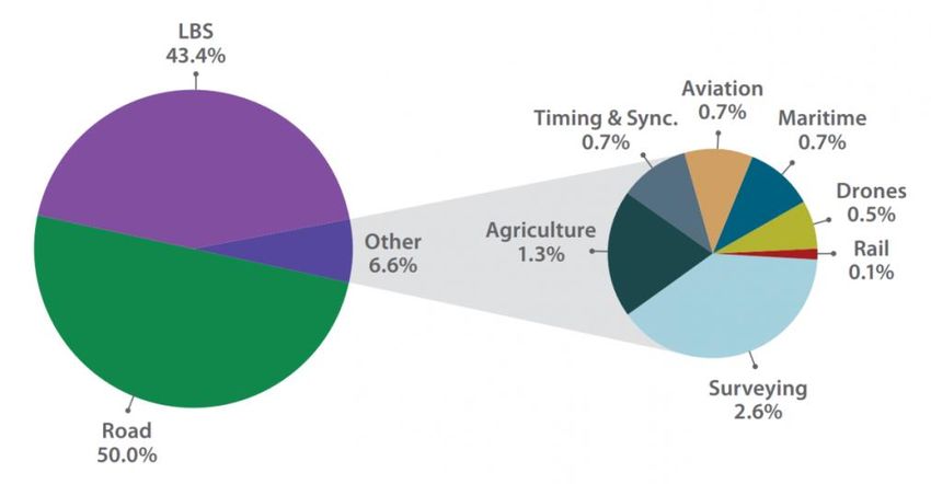
4.1 Satellite navigation systems market overview ............................................................................... 26
14.1.1 Value of Finnish space and satellite navigation market ........................................................ 28
4.2 Logistics ............................................................................................................................................... 29
4.3 Automated transport .......................................................................................................................... 30
4.4 Utilisation in road traffic ..................................................................................................................... 32
4.4 Utilisation in rail traffic........................................................................................................................ 35
4.4 Utilisation in maritime transport ........................................................................................................ 36
4.4 Utilisation in aviation .......................................................................................................................... 39
4.8 Utilisation in official activities ............................................................................................................ 40
4.9 Utilisation in agriculture and land surveying................................................................................... 41
4.9.1 Agriculture .................................................................................................................................... 41
4.9.2 Land surveying ............................................................................................................................ 41
4.10 Use in location-based software and content services ................................................................ 42
4.11 Utilisation in time synchronisation ................................................................................................. 43
5. Actions ....................................................................................................................................................... 45
Abbreviations ................................................................................................................................................. 50
2In this Action plan satellite radionavigation includes positioning and time data as
well as the services needed for their utilisation. During the preparation of this Action
plan, the Geospatial data study is also being prepared for which reason this Action
plan does not deal extensively with location data, which is often shown with maps.
With regard to automated transport, it is of key importance that positioning and
maps are up to date and reliable.
1. Introduction
As society has become digitalised, satellite navigation has become an important
part of our everyday lives. For example, the operation of power and
communications networks and transport services requires satellite positioning and
accurate timing. In addition, satellite positioning is utilised in many other areas of
everyday life, such as in the monitoring of people with dementia and prisoners. In
2017, the European Commission estimated the current value of the satellite
navigation sector at over EUR 70 billion. Smartphone services account for the
majority of this sum.
The efficient utilisation of satellite navigation was incorporated into Sipilä's
Government's key project Creating a growth environment for digital business
operations. The objective of the key project is to make Finland a favourable
operational environment for digital services and digital-based business models.
Work to develop the digital growth environment is carried out under the lead of the
Ministry of Transport and Communications (herein after MTC).
The Government-appointed space advisory board has drawn up a national space
strategy for 2013–2020 to facilitate the realisation of national objectives. The
strategy has been taken into consideration when preparing this Action plan.
Finland's needs in the global operating environment set the premise for developing
Finland's space sector, and the strategy outlines the primary development
objectives in the fields of space activity Finland is active in and which are funded
from the Government budget.
The vision for the National Strategy for Finland’s Space Activities 2013–2020 is for
Finnish actors to represent the world's leaders in space science, data-based
business and their utilisation in society by the time the strategy period comes to an
end. The strategy outlines four extensive key projects, whose main aim is to
develop Finnish research expertise and the competitiveness of companies
especially in the Arctic region and the utilisation of open data. Within this Action
plan, the Arctic region is understood to be more extensive than the region north of
the Arctic Circle. This area covers the whole of Finland.
1Internationally-speaking, in 2016, the European Commission published the Space
Strategy for Europe, which has also been taken into account in the preparation of
this Action plan. The Space Strategy for Europe states that space technology,
space data and space services have become essential and that the most broad-
scoped opportunities facilitated by space solutions and data have yet to be utilised.
In order to utilise the significant opportunities space has to offer, the European
Commission has determined that Europe must work together and keep at the
forefront utilising all available skills, expertise and investments. In 2017, Finland
drafted the Act on Space Activities, which will promote the development of new
space innovations and business opportunities.
Europe is undergoing an important phase in satellite navigation as the Initial
Services of Galileo, the European Global Satellite Navigation System (GNSS),
have just begun operating. The plan is to have the system fully operational by
2020. The Galileo satellite navigation system is the first system intended entirely
for civilian-use, and it is expected that its deployment will improve the efficiency of
business in Europe and thus also in Finland.
1.1 Objective of the Action plan
The objectives of this Action plan include:
1. guaranteeing the utilisation of satellite navigation systems and the quality of
positioning throughout Finland in all of society's sectors as well as to encourage
every administrative branch to draw up a plan for the utilisation of satellite
navigation
2. making Finland one of the world leaders in the utilisation of various satellite
navigation systems and in the provision of location data services in the Arctic
region
3. promoting the utilisation of satellite data in business and in the provision of
services
4. promoting the utilisation of small satellites and improving the operating
conditions for Finnish high quality space research
5. determining the need and possibilities for establishing a space administration
in Finland The objective is not to establish a new agency, but activities could
be centralised with one existing actor.
22. Current status of satellite navigation systems
2.1 GPS, Galileo, GLONASS, BeiDou and EGNOS
Of Global Navigation Satellite Systems (GNSS) the ones that are currently fully
operational and continuously modernised are the American GPS and Russian
GLONASS. The European Union's Galileo and China's BeiDou are in their
deployment phase, which means that some of the systems' functionalities are
already in use. Galileo is expected to be fully operational in 2020, and BeiDou is
currently expanding from a local system into a global navigation satellite system
by 2020. At the moment, BeiDou is fully operational locally in China and its
surrounding countries. India (IRNSS) and Japan (QZSS) are developing local
satellite navigation systems.
The European Geostationary Navigation Overlay Service (EGNOS) is a satellite-
based augmentation system that supplements the GPS system's operations for
users in Europe. In the future, the augmentation system is to also cover Galileo's
signals. Initially, the system was to also help the GLONASS system, but this was
discarded.
Numerous satellite navigation systems and their supporting systems together
facilitate an endless number of uses and services in the areas of positioning,
navigation and accurate timing. The accurate timing refers to time synchronisation
in areas that require the exact time such as banking, telecommunications and the
supply of energy. In the area of research as well as in practical work in matters
related to land surveying and geodesy the shared use of a satellite navigation
system will decrease measurement uncertainty and facilitate more accurate and
reliable measurements as well as new methods and applications. Finland's
coordinate system has been based on satellite observations by FinnRef ground
stations since 1998.
New GNSS systems and the modernisation of existing ones increase the number
of satellites and frequencies available so much that location and time
determination are more effective even in the most challenging conditions, such as
in street canyons and forests, more efficient than today, when there are only GPS
or GPS and GLONASS satellites. However, satellite positioning is not available
everywhere such as indoors and in tunnels, which means the need to combines
other location determination technologies to satellite positioning remains.
A global satellite navigation system that works in general is achieved with 18 to 30
satellites. Satellite-based augmentation systems have been developed to
supplement satellite navigation with the help of ground stations, computer centres
and other satellites. The systems in question monitor GNSS satellite signals and
3factors that influence GNSS signals very carefully at ranging and integrity
monitoring stations. On the basis of these measurements, the corrective data and
reliability estimates for positioning can be calculated, which are then sent to the
user via satellites that are on geostationary orbits. Satellite positioning is based on
precision timing: the travel time for the signal can be determined by calculating the
difference between the transmission time for satellite-sent radio signals and their
reception time. This will determine the distance between the satellite and the
receiver. Four distance measurements help in determining the receiver's 3D
position coordinates in the global coordinate system as well as the time difference
between the receiver clock and the time logged in the satellite system. This will
help in achieving PNT (Position, Navigation, Timing).
2.2 European Galileo and EGNOS programme services
Development of the European Galileo programme began in 2003. In December
2016, the Commission adopted its first declaration on the services provided by the
Galileo programme. There are currently 18 satellites in orbit, of which 15 are fully
operational, the services of two satellites which are on the wrong orbits can be
utilised in part and one is not in use. A further four satellites are to be launched by
the end of 2017. The aim is that the Galileo programme will be fully functional and
in force in 2020, at which time there should be 24 satellites and some spare
satellites in use. The Galileo programme is the first satellite positioning system
entirely intended for civilian use, and it will ensure Europe's independence from
other satellite systems and improve Europe's operational reliability.
The EGNOS programme was adopted in 2009. The EGNOS service produces the
corrective adjustments for positioning on the basis of observations made at 39
RIMS stations, and the data is transmitted via three geostationary fixed satellites.
Geostationary fixed satellites are visible in Finland at low angles of elevation, which
presents challenges for the availability of corrections. Finland's only RIMS station
is located in Virolahti. Problems in the quality of EGNOS corrections have been
observed in northern and north-eastern Finland. This is because a sufficient
number of RIMS stations being unable to detect satellites rising from the east,
meaning the correction does not apply to them. Disruptions in the ionosphere
caused by the activeness of the sun can also require higher location accuracy than
average in corrections at higher latitudes. The Commission has promised to four
new RIMS stations, one of which would be located in Kuusamo. The new station
in Kuusamo would significantly improve the reliability of overall positioning and
serve air traffic in particular. At the moment, the Commission and the GNSS
Agency are assessing the technologies with which RIMS stations will be equipped.
From Finland's perspective, Kuusamo's RIMS station should be based on ENGOS
V3 technology. It is believed that this technology will solve Finland's quality
4problems. This new technology could be in use sometime between 2023 and
2025.
The Galileo programme provides access to an Open Service (OS), a Commercial
Service (CS), a Public Regulated Service (PRS) and a Search and Rescue Service
(SAR). The quality and availability of the OS and CS are described in Table 1.
The commercial service's service level is determined by the service operator within
the limitations of the Galileo system. Galileo's service description sheet1 from
2002, on the other hand, describes the minimum performance for distance
measurement satellites using one or two frequencies, which cannot however be
directly turned into accuracy performance assessments. The GNSS Agency has
also recently published the first performance report for the open service , which
states that horizontal and vertical positioning errors (95%) are significantly better
than their target values i.e. 3.56 m and 4.12 m.
Service Open Service Public
Regulate
d Service
Abbreviation OS PRS
application
Frequencies (number 1 2 2
of)
Coverage: Global Global
Accuracy of horizontal 15 4 6.5
positioning (m)
Accuracy of vertical 35 8 12
positioning (m)
Timing accuracy (ns) - 30 100
Service Availability% 99.8 99.5
Integrity available No Yes
Alarm level - 20
limit altitude - 35
(m)
Alarm delay (s) 10
Atmospheric correction Yes Ye Yes
s
Year of deployment 2016–2018 2018-
2020
Figure1: Goal accuracy of Galileo's Open Service and Publc Regulated Service
1 http://ec.europa.eu/transparency/regdoc/rep/1/2002/EN/1-2002-518-EN-F1-1.Pdf
52.2.1 Galileo's Open Service
The Open Service (OS) is accessible to users free of charge and produces
positioning and timing data for satellite navigation mass applications. The Open
Service ensures that satellite navigation systems operate globally, regardless of
the availability of a single system. Galileo also increases the number of satellites,
its positioning is more reliable and it provides improved accuracy. However, the
Open Service does not provide information on the integrity of the system.
Galileo offers three signals at nearly the same frequencies and the same way as
the GPS system, so it is easy to manufacture Galileo-compatible locators for
smartphones, navigators, cameras and other positioning devices. It has been
estimated that inexpensive devices that use one frequency can achieve a
horizontal positioning accuracy of at least 15 metres and a vertical positioning
accuracy of 35 metres. Positioning that utilises two frequencies achieves a
horizontal positioning accuracy of 4 metres and a vertical positioning accuracy of
8 metres.
The Galileo programme's Open Service contains a navigation message
authentication feature (OS-NMA), which makes it possible for users to be certain
that the service's navigation signal is really from the Galileo satellites.
Authentication reduces the possibility of external parties intentionally interfering
with the satellite positioning receiver so it shows incorrect time or location data.
Authentication will be deployed in 2018, and this will be open to everyone, free of
charge. In order for it to be possible to use authentication, the receiver must
support the feature and a public encryption key be installed to it. The use of
authentication is not mandatory. The Galileo receivers function even when they
are not able to process authentication data. Other GNSS systems do not include
an authentication feature that is available for all users, meaning this a notable
strength for the Galileo system.
The time signal for the Open Service could be used to facilitate the synchronisation
of various systems and applications, such as ICT systems and banking systems.
2.2.2 Galileo's Commercial Service
The Commercial Service (CS) supports applications developed for professional
and commercial use. These offer better and more accurate positioning than the
Open Service. A service promise is to be given for the Commercial Service
covering availability and interruptions in service, the length of these interruptions
as well as the practices related to their elimination. The service is transmitted by
6operators, who purchase the right to use the signal from the Galileo operator
together or separately from open signals. The service is a global one.
The Commercial Service provides two significant improvements compared to the
Open Service:
- more accurate geographical location determination, "high-resolution CS" and
- a more efficient authentication capacity "authenticated CS".
These can be delivered to users independent of one another. Data that facilitates
high resolution travels with the Galileo satellite signal and is subject to a charge.
The objective is to achieve a positioning error of less than one decimetre. At its
simplest, an authenticated CS can use the OS's authentication capacity, but the
separate encrypted codes sent in the CS signal provide additional protection
against counterfeit signals. The encrypted codes make it possible to identify
signals sent from Galileo. Users must pay a fee for encryption keys for the codes.
2.2.3 Galileo's Public Regulated Service
The Public Regulated Service (PRS) is reserved exclusively for users authorised
by public administration. The service offers signals with strong encryption for
applications that require service continuity in normal conditions, during disruptions
and in exceptional circumstances. The service is encrypted and designed to
operate reliably in spite in attempts at interference and distraction. The service
includes solutions that filter interference the technical specifications of which are
kept confidential. Use of the service requires that the receiver is able to decode
the encrypted signal.
The service is primarily intended for use by the authorities, and to support
applications that are strategic and critical for society. Typical users include the
police, rescue services, border control, customs and the defence forces and actors
who play key roles in the provision of logistics that influences energy supply,
telecommunications, banking activities or society's vital functions. The service is
to function in all conditions.
The availability of the service is controlled by authorities appointed by the
European Union. Authorities from EU Member States are responsible for the
distribution of devices. Nationally, the Ministry of Transport and Communications
makes decisions on the user groups who are authorised to use the PRS. The
national PRS authority grant access rights. In Finland this authority is the Finnish
Communications Regulatory Authority. The national PRS authority's areas of
responsibility also include the administration of PRS devices and seeing to
7supervision, key administration as well as export supervision in the case of
industry.
2.2.4 Galileo's Search and Rescue Service
The Search and Rescue Service (SAR) picks up emergency signals from the alarm
transmitters and transmits messages to the COSPAS-SARSAT system's search
and rescue service. COSPAS-SARSAT is a global rescue system which steers
emergency signals from the transmitters of located ships, aircrafts, emergency
buoys, etc. automatically via satellites to the nearest search and rescue
organisations.
The Galileo system's satellites will receive and transmit emergency signals. When
at full operating capacity, the system's satellites cover the entire Earth at all times
and are able to also transmit return message on the reception of an emergency
message.
The Galileo SAR service will further improve the status of those who currently use
the COSPAS-SARSAT with regard to the coverage of the service and accuracy of
the emergency transmitter's positioning, particularly in the north. The
acknowledgement message in the form of a return signal is also a notable
improvement to the quality of service. This will inevitably increase the willingness
of people to utilise the service, in particular for recreational and tourist purposes,
thus improving the safety of mobility in Finland.
2.2.5 EGNOS's Open Service
The EGNOS programme's Open Service was deployed in 2009. The accuracy of
Galileo's positioning can in future be improved when using corrective data from
EGNOS or some other support service. Today, EGNOS only improve the accuracy
of GPS, but in the future the system will also be able to do so for Galileo positioning.
In good signal conditions EGNOS can provide an accuracy of approximately one
metre.
2.2.6 EGNOS's Safety of Life Service
The satellite-based EGNOS support system's safety of life service (SoL) has been
available in Europe from 2011, when it was approved for use by air traffic. In the
near future, the service will also be extended to maritime transport. The Safety of
Life Service is mainly a safety critical service and is only related to ensuring
immediate safety for human life. The service aims to ensure the safe use of the
8positioning system and warns system users of system disruptions such as the
malfunction of a satellite or another part, which can weaken the accuracy of
positioning. Signatures can be added digitally to messages in the service, which
will ensure that the receiver can be certain of the authenticity of the message.
The service warns the user, when the system should not be used for navigation.
The integrity of the system is even more important than its positioning accuracy.
This means that the different parts of the system must function flawlessly. When
there is a possibility that the accuracy of positioning has been compromised above
a certain limit value, the service sends a warning to the user. The limit values are
set separately for horizontal and vertical positioning accuracy for different user
groups.
2.2.7 Timetable for the implementation of Galileo services
The test use of Galileo's Open System and Search and Rescue System began in
December 2016. Test use of the Public Regulated Service will begin in 2018 and
the service will be fully operational by the end of 2020. All the services should be
deployed in phases by the end of 2021.
Figure 2: Timetable for the implementation of the Galileo programme. European Commission,
Galileo FOC Programme Roadmap, 12 December 2016.
92.3 Challenges related to satellite navigation systems
2.3.1 Coverage problems affecting North European satellite navigation systems
Satellite navigation programmes and their associated support systems do not
perform optimally at high latitudes and especially in the Arctic region in particular
in determining vertical positioning. This is due to the satellite constellation i.e. the
way satellites are situated on their orbits. However, Galileo provides a somewhat
better coverage in higher latitudes than GPS, whereas GLONASS provides the
best possible coverage due to its highest inclination angle. There are problems
with geostationary navigation systems (EGNOS) in Northern Europe, because the
satellites that send support signals are poorly visible in norther areas and the good
reception is not possible.
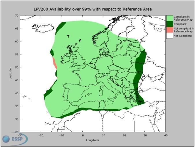
Services provided by EGNOS, the support system for satellite navigation, are
available in Central Europe, but for the time being not all services are available in
Northern Europe (e.g. LPV200). The greatest problems with coverage have been
observed in Finland (see Figure 3 below). Coverage problems mean that the
service cannot be utilised in Finland for example in air traffic.
Figure 3: EGNOS coverage problems in Finland (January 2017, GNSS Agency)
102.3.2 Interference and jamming
Satellite navigation signals, like other radio frequency signals are susceptible to
both unintentional interference and deliberate jamming. However, this problem is
particularly challenging and more difficult to resolve in satellite navigation, as
satellite navigation signals are very weak in strength after traveling from space to
Earth and are therefore prone to interferences. Sources of satellite navigation
interference include the he free electrons created by the sun's UV radiation in the
ionosphere, which angle the satellite signal and various terrestrial systems that
interfere with the progress of the satellite signal. The free electrons in the
ionosphere interfere with signals especially when the sun is at its most active in
eleven year cycles, but temporary solar storms can also cause significant
interference to the progress of satellite signals and cause errors in distance
measurements between the satellite and the user.
The most common unintentional terrestrial sources of interference sources are
electric devices near the reception point. In addition, various types of RF
transmissions may affect the reception of satellite navigation. For this reason, it is
very important to place the fixed satellite navigation receiver antennas correctly,
avoiding electromagnetic interference to electronic and radio devices. The quality
of the satellite navigation receiver will also have a significant impact on how
susceptible it is to interference. It is also good to be aware that when
malfunctioning any radio device can radiate on the wrong frequency jamming other
radio systems. This will require the case by case investigation and elimination of
radio interference. Intentional jamming is carried out with devices that deliberately
send a radio frequency signal sufficiently effectively and with such signal
characteristics that prevent or hinder the monitoring of satellite navigation signals
in certain areas or deliberately send misleading signals to the receiver. If the
FinnRef positioning service is used to support positioning, the service can help in
identifying interference and jamming. The service can make it possible to create a
quality instrument for satellite positioning in Finland.
New frequency bands and positioning codes that are not as susceptible to
interference have been planned for satellite navigation systems that are being
modernised. The frequencies of signals have also been taken into consideration
in Galileo and susceptibility to interference when planning codes. In the future,
numerous modernised satellite navigation systems will be in shared use meaning
that it will be increasingly difficult to jam all the available frequencies at the same
time.
112.3.3 Support Systems
Satellite positioning provides outdoors location determination in global coordinate
system. Its accuracy varies depending on environmental factors and the reception
technology in use as well as depending on possible aiding systems or reference
networks. Satellite signals are often too weak to be received indoors or for example
in tunnels, which means that supplementing technology is needed for positioning.
Tall buildings in urban areas hinder the progress of satellite signals. Other
supporting and parallel positioning technologies will be needed alongside satellite
positioning systems so that for example navigating the progress of a pedestrian
from the outdoors to the indoors can be seamless, accurate and easy. Aiding
navigation technologies include inertial navigation technologies2 and wireless
positioning methods, Wireless positioning methods include positioning based on a
mobile mast signal (e.g. 4G),methods based on the measurement of wireless LAN
signal strength (e.g. WLAN) positioning based on Bluetooth technology, remote
sensor positioning based on RFID chips ultrasound and infrared positioning and
time-delay positioning based on ultra wideband signals (UWB). Other aiding
positioning technology include cameras and fixed physical locations equipped with
sensor reflectors.
2.3.4 Preparedness
As Finnish society has experienced general technological progress and
digitalisation, it has become very dependent on the usability of reliable timing and
positioning data. Just like any other radio system, satellite navigation is not
available everywhere and at all times. Especially the operating capability of the
police and rescue authorities suffers if satellite-based positioning data is not
accessible. Telecommunications networks, banking systems and many other
functions that are significant to a fully functioning society will cease or work
properly without the highly accurate time signal that most often originates from
satellites.
These days, the GPS system is used for time and location data. In the future
Galileo Public Regulated Service (PRS) will strive to ensure that critical actors can
receive satellite signals even in poor conditions
2.4 Location data from the perspective of privacy and protection of personal
data
2 Inertial navigation is based on the measurement of acceleration.
12Regulation that applies to location data has been fragmented into a number of
provisions. The applicable regulation depends on whether information processing
includes the processing of personal data (according to either general or special
legislation) electronic communication or data related to geography and
infrastructure. The abundance of regulation has is in part related to the fact that at
the level of fundamental rights, location data is linked to privacy protection,
protection of personal data, freedom of movement, freedom of expression and the
principle of public access to information possessed by the authorities.
Personal data includes all information related to an identified or identifiable natural
person. An identifiable person is natural person, who can directly or indirectly be
identified for example on the basis of identifying data such as their name or even
their location. Location data is thus personal data, of it can be linked directly or
indirectly to a natural person.
The processing of personal data is provided for in the Personal Data Act. On 25
May 2018, this will be replaced by the European Union's General Data Protection
Regulation. The processing of all personal data necessitates grounds for
processing pursuant to personal data legislation. Grounds for processing can
include permission from the registered party or a law provision. When personal
data is processed, the controller must see to it that the registered party's rights are
released and that the controller fulfils the statutory obligations prescribed to it.
Information security and data protection must be guaranteed. Additionally, it must
be ensured that personal data is only used for purposes that are compatible with
the intended use. If the information is to be used for other purposes, the registered
party must provide permission for this or the special conditions for processing must
be enacted into legislation.
Special legislation that applies to a specific sector has also been laid down on the
processing of personal data. Special legislation has been laid down on transport
and intelligent transport. Below is a description of the Commission's activities
related to C-ITS systems. Legislation on electronic communication contains
special provisions on the processing of person data. The legislation applies to
communication carried out with those electronic communication services that are
commonly used and available. Provisions on location data in electronic
communication applies to communication service providers as well as added-value
service providers. Key statutes that apply to electronic communications have been
collected in the Information Society Code and regulation is based on the Directive
on privacy and electronic communications. The Commission has announced that
it will examine the directive on the basis of the EU's information security reform
and in January 2017 it submitted a proposal that the directive be replaced by a
regulation. It would be a significant reform if regulation applied to all
communication service providers in a technology-neutral manner.
13The provisions in the Information Society Code that apply to the processing of
personal data are not usually applied to satellite positioning, because satellite
positioning does not utilise public communication networks. If these definitions
change along with new EU regulations, this may also have an impact on the
processing of personal data in satellite positioning. Positioning itself happens with
a positioning device that receives a navigator signal calculates the location,
direction and speed of the device on the basis of this. The collection of data
happens in the positioning device and satellites do not process location data. Also
other processing of personal data may be carried out on the positioning device, if
it has the necessary features, or the data can be moved from the positioning device
to another device or service.
However, the mobile network and wireless local area network can be used for the
transmission of location data and to support positioning. Positioning devices often
transmit information via public communications networks. Positioning data is
usually relayed over the mobile network to various services and applications, and
it is usually an essential part of the service. In addition, for example positioning
systems in mobile phones generally use satellite positioning data as well as
positioning data that can be accessed via public communications networks.
Telecommunications networks provide a parallel positioning method, for example,
indoors or they may provide assistance, which allows a faster start to positioning
or improved accuracy of positioning. In such cases, the data protection rules for
electronic communication data providers and added-value service providers apply.
As a rule, in any other case general personal data legislation applies.
Geographical data differs from location data. Geographical data refers to all
information that contains a direct or indirect reference to a certain place or
geographical area. Regulations that apply to geographical data predominantly
applies to the availability of such data from public materials and registers.
Geographical data has not as a rule been considered personal data. However,
location data can be linked to individual people in which case it is personal data.
In this case, general personal data legislation applies, if there are no special
provisions on the matter.
On 31 November 22016, the European Commission published a Communication
on the strategy on interactive intelligent transport systems (ITS-C). The strategy
states that the protection of personal data and privacy is a deciding factor in the
successful deployment of automated vehicles equipped with an interactive network
connection. Users must be able to rely on it that their personal data will not be
treated as merchandise and that they can effectively track how and for what
purpose their information is used. Satellite positioning is used to locate vehicles
and location data can in principle be considered personal data, because they are
related to the identified or identifiable natural person via the vehicle's identifying
14data. For this reason, the implementation of the C-ITS must comply with applicable
data protection legislation.
As part of the C-ITS Platform project, the Commission, together with public and
private actors is looking for solutions to problems related to the ITS deployment
issues, so that the first services could be introduced in 2019. One area that
requires solutions are issues related to data and privacy protection. The C-ITS
Platform will complete its work in September 2017 after which the Commission will
decide on any further actions. The Intelligent Transport System Directive
2010/40/EU (ITS Directive) also makes it possible for the Commission to adopt
delegated legislative acts that are binding to Member States. In its C-ITS strategy,
the Commission stated that it will consider the use of delegated powers to ensure
the implementation of the information security regulation in the C-ITS sector.
2.5 Systems that supplement satellite navigation systems and parallel
systems and in particular systems that serve automated transport
2.5.1 Communication networks and other technologies
More than one method is used for determining the geolocation of automated
vehicles. These methods include data transfer methods (e.g., ITS-G5, WiFi, UWB,
Bluetooth or LTE), cameras, radars and physical landmarks. The location is
produced through the fusion of the location data produced by them.
There is more need for communication between vehicles as road traffic is
becoming increasingly automated. Cooperative Intelligent Transport Systems (C-
ITS) allow vehicles to communicate on their own movements or relay information
about traffic conditions. Vehicles can send information about their own location on
a continuous basis and use outside information services through the mobile
communications network infrastructure that they are connected with. Vehicles can
communicate with each other directly or through communications networks.
Air navigation can be based on one or more systems and sensors. As a rule,
depending on the flight phase and the equipment available to the aircraft, a satellite
navigation system or ground-based radio navigation equipment are used as the
primary system. The systems on board the aircraft, such as inertia systems and
the gyro compass, can also be used. Traditional ground-based navigation
equipment operating analogically on the basis of radio signals include Distance
Measuring Equipment (DME) and the Instrument Landing System (ILS), which will
remain in used at least until the 2030s. VHF Omni-directional Range (VOR) has
already been largely replaced by satellite-based systems. In addition to the
15ground-based infrastructure and satellite navigation systems, navigation is also
supported by radar control.3
Navigation systems relying on ground-based infrastructure are used in rail traffic.
This technology is expected to remain in use until the end of the 2030s. Radar and
radio systems, visual safety systems, pilots and printed nautical charts are still
used in maritime traffic in addition to satellite navigation. Potential uses of a broad
range of different technologies are examined as part of the development of
autonomous ships.
2.5.2 Utilisation of earth observation data in automated transport
Different types of information, including open and free-of-charge earth observation
data, is available as part of the Copernicus earth observation programme of the
EU. Exploiting its broad potential is still in its early stages, which means that only
a small part of the full programme impact is known. Combining earth observation
data with detailed terrestrial observations as well as weather and conditions
models will produce the best possible information on traffic conditions. When this
information is used in automated transport, consideration can be given to the
impacts of weather and damage to transport infrastructure on an up-to-date basis.
This will significantly improve the safety of automated transport. Satellite
navigation and information on traffic conditions can help to anticipate the
challenges on the route in real time. This applies to all modes of transport. As a
result, the existing traffic information systems can be expanded, especially in road
transport. Even though the information is already used in maritime and air traffic
but information tailored to the needs of different users assumes more importance
as it is more often available and more extensively accessible.
2.5.3. Services that correct positioning
Corrective measurements for satellite positioning are not only produced by
geostationary satellites (EGNOS in Europe), but also by commercial operators in
the form of differential corrections Corrections are standardized and in use to
improve accuracy and reliability. In addition to its fundamental role as the basic
network of the national coordinate system, FinnRef network also provides open
data and differential correction services on which private companies, too, can build
their own services and generate added value. In addition, FinnRef facilitates a
secured service for the State's critical functions (i.e. the Defence Forces, the
3Today’s aircraft have ILS, DME and VOR as standard equipment. VOR is likely to be replaced by
GNSS and DME. DME will probably be used as backup for GNSS for many years to come.
16security sector and taxation). Data can also be used for research in either national
or international projects.
The most accurate positioning and navigation applications use a carrier phase
measurements and regional support services, such as RTK (Real Time Kinematic)
NRTK (Network Real Time Kinematic). In Finland, the commercial NRTK service
is offered by Geotrim Oy and Leica Geosystems Finland via a national network of
approximately 100 ground stations. The National Land Survey of Finland
(hereinafter the NLS) is currently developing the FinnRef positioning service. In its
first stage it will provide the positioning accuracy required by the NLS's own
deliveries to its properties. This will be made possible by 40-50 ground stations the
construction of which will be completed by 2019.
PPP technology (Precise Point Positioning) is developing rapidly and as
multisystem technology and receivers are becoming less expensive, it will be able
to challenge in the next few years traditional DGNSS (Differential Global
Navigation Satellite System) technology, offering decimetre-level navigation
accuracy in real time. There are already companies providing correction services
based on geostationary satellites (such as OmniStar and TerraStar), which allow
DGNSS and PPP solutions to be used in global scale. It is also probable that PPP
corrections will be sent with Galileo's CS. This would significantly improve the
availability of corrections in Finland. The FinnRef positioning service can speed up
the launch of the PPP service
2.5.4 Small satellites
Along with traditional satellites small satellites have now also opened up
possibilities for smaller countries, such as Finland, for companies, and for
individual research institutes as paths to near space. Whereas a traditional large
satellite weighs approximately 500 kilograms, nanosatellites which are one version
of small satellites weigh 1 to 10 kg. They also cost a fraction of the price of a large
satellite. In spite of its size, the payload of a smaller satellite is almost as good as
that of a larger satellite. In fact, space provides new and unique commercial
opportunities for Finnish industries, startup companies and space researchers.
According to Tekes, there are about 80 Finnish companies that design satellite
instruments, structures and software or use satellite data in their business.
In addition to traditional research organisations and equipment and application
suppliers, the opportunities offered by the New Space Economy are also attracting
new operators to the sector in Finland. New Space activities often involve new
operators that are commercially oriented and independent of the state. New Space
provides an easier and less expensive access to space through such platforms as
17You can also read