EREEFS CASE STUDY - CSIRO
←
→
Page content transcription
If your browser does not render page correctly, please read the page content below
APRIL 2016

EREEFS CASE
STUDY
1 EREEFS CASE STUDY 1
eReefs case study
CASE STUDY SUMMARY
Key findings
— The results of the eReefs research will significantly transform our ability to manage and protect the Great
Barrier Reef and assist in its long-term preservation. It has delivered powerful real-time visualisation and
reporting tools that will provide users with real-time information about the condition of the Reef.
— The eReefs models are being used by the Great Barrier Reef Marine Park Authority and the Queensland
government to aid decision making, and by the Bureau of Meteorology to deliver remote sensing products
based on CSIROS algorithms.
— CSIRO has negotiated an agreement with Chile to create a similar model for their coast region to help them
protect the sustainability of their salmon sanitation program
— Based on conservative assumptions, the net present value of benefits to 2025-26 from the eReefs project is
$80.8 million in 2015-16 dollars under a 7 per cent real discount rate. The project has a benefit-cost ratio of
over 10.
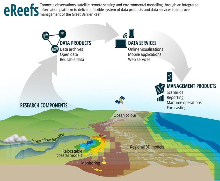
Innovation impact
The CSIRO eReefs project team has delivered highly innovative science, namely the eReefs information
platform. The centrepiece is a whole-of-region, shelf-scale, numerical marine modelling system. The project
team has also developed a highly innovative, web-based modelling environment called RECOM (RElocatable
Coastal Ocean Model) that users can easily access to quickly establish a model of an area of interest such as
an estuary, bay or coral reef.
This case study uses the evaluation framework outlined in the CSIRO Impact Evaluation Guide. The
results of applying that framework to the eReefs case study are summarised in Figure 1.1.
1
EREEFS CASE STUDY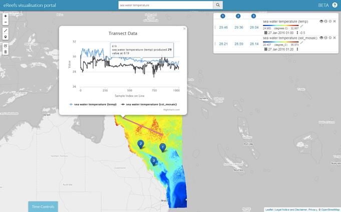
FIGURE 1.1 CSIRO CASE STUDY EREEFS - IMPACT FRAMEWORK DIAGRAM
INPUTS ACTIVITIES OUTPUTS OUTCOMES IMPACTS
Funding from the Research to expand A comprehensive Monitoring and Economic impact
Science and Industry and improve coastal information management More efficient and
Endowment Fund monitoring data system interventions on Reef profitable tourism
(SIEF) Developing a suite of Tools such as the catchments activities and port and
Funding from the new and integrated Marine Water Quality Tracking rainfall and shipping operations
Great Barrier Reef models Dashboard and flooding impacts More efficient decision
Foundation (donors Testing and RECOM Assessing cumulative making
are BHP Billiton, verification of the Journal and threats Reduced costs for
Mitsubishi and models conference Engagement with the aquaculture firms
Queensland Developing a publications community
Government) National and
framework to explore A contract with Chile international contracts
Additional funds from the impact of multiple to build a similar
GBRF and the Bureau Environmental impact
factors model for them.
of Meteorology Improved water quality
Developing an
In kind support from interactive visual Natural hazards
Queensland picture of the Reef mitigation (floods,
Government, CSIRO, and its component cyclones and land
BoM and AIMS parts. runoff).
CSIRO provided Improved marine bio
Citizen science
resources to facilitate ecosystems.
initiatives
the partnership. Reduced likelihood of
serious environmental
damage
Social impact
More resilient regional
communities,
particularly those
reliant on tourism
SOURCE; ACIL ALLEN
1.1 Background
1.1.1 Purpose and audience for case study
This case study describes the economic, environmental and social benefits arising from CSIRO’s and
its partners’ research on the Great Barrier Reef (the Reef).
Audiences for this study are likely to include Ministers and their offices, the public, and CSIRO’s
customers. The document will also be used within the CSIRO by groups such as the Science,
Strategy, Impact and Investment Committee (SICOM) and the Business Unit Review team.
1.1.2 Project origins and inputs
The Great Barrier Reef, the world’s largest coral reef system, is one of the seven wonders of the
natural world and was the first coral reef to be included on the UNESCO World Heritage List. The reef
is not only a natural wonder it is a source of considerable economic activity. The majority of the value
added and employment generated is from tourism. A 2013 report estimated that there was almost
$5.2 billion in value-added and about 64,000 FTE (full time equivalent) jobs generated by that sector.1
However, the Reef is under threat. For example, the Great Barrier Reef Marine Park Authority’s 2014
Outlook Report stated that:
1 Economic contribution of the Great Barrier Reef, Great Barrier Reef Marine Park Authority, Townsville, Deloitte Access Economics, 2013.
2
EREEFS CASE STUDYClimate change, poor water quality from land-based run-off, impacts from coastal development, and
some remaining impacts of fishing remain the major threats to the future vitality of the Reef.
In October 2012 the Australian Institute of Marine Science issued a report that declared that coral
cover had declined by 50% in just 27 years, illustrating the significant cumulative impact of the various
pressures on the Great Barrier Reef.2
Due to the Reef’s scale and complexity it is not currently possible, to visualise, model, understand and
communicate about the whole of the Reef system. A number of Commonwealth and State initiatives
have been implemented to address the problems facing the Reef.
The eReefs project commenced in January 2012. It was the first effort to build a comprehensive
coastal information system for the Reef. It uses the latest technologies to collect and collate data and
new and integrated modelling, the eReefs project will produce powerful visualisation and
communication tools to provide real-time and scenario information that can be used to aid
assessments and inform decisions on a range of issues including about the quality of water in the
Reef, hydrodynamics conditions for safe navigation or incident response, and the likely occurrence or
spread of ecological pests such as the crown-of-thorns starfish.
The eReefs project is a public-private collaboration between Australia’s leading operational and
scientific research agencies, government, corporate Australia and Reef managers. Partners in the
eReefs project are the Great Barrier Reef Foundation (BHP Billiton, Mitsubishi and the Queensland
and Australian governments provide funds to GBRF), the Bureau of Meteorology (BoM), CSIRO, the
Australian Institute of Marine Science and the Queensland Government. Funding for the project is
provided by a variety of groups (see Table 1.1).
TABLE 1.1 SUPPORT FOR THE EREEFS PROJECT
Organisation Phase 1 Phase 2 Phase 3 Total Type of
2012-13 2014-15 2016-17 Support
CSIRO 3.222 4.190 0.438 7.850 in-kind
Australian Institute of Marine Science (AIMS) 0.515 0.418 0.293 1.225 in-kind
Bureau of Meteorology (BoM) 3.016 1.094 1.265 5.376 in-kind
Queensland Department of Science, Information Technology
- 0.380 0.580 0.960 in-kind
and Innovation (DSITI)
Great Barrier Reef Foundation (GBRF) 2.492 4.671 5.043 12.206 cash
Science and Industry Endowment Fund (SEIF) 2.000 1.600 0.400 4.000 cash
TOTAL 11.245 12.353 8.019 31.617
SOURCE:CSIRO
The eReefs project has three Phases. Phase 1 ran from January 2012 to November 2015. The total
cost of Phase 1 was $11.25 million. CSIRO contributed cash for phase 1 through its Science and
Industry Endowment Fund (SIEF). Its direct contribution was an in-kind one (instrumentation,
laboratories, etc.).
Phase 2 was completed at the end 2015. Phase 3 will be undertaken between 2016 and 2017.
Expenditure for Phases 2 and 3 is expected to be around $20.4 million. Phase 2 and phase 3
contributions to the project are shown in Table 1.1.
1.2 Project activities
The key activities undertaken during Phase 1 include:
2 http://www.aims.gov.au/docs/media/latest-releases/-/asset_publisher/8Kfw/content/2-october-2012-the-great-barrier-reef-has-lost-half-of-
its-coral-in-the-last-27-years
3
EREEFS CASE STUDY— Developing a suite of new and integrated models across paddock, catchment, estuary, Reef lagoon
and ocean. These models integrate the outputs of three component models (hydrodynamic,
biogeochemical and sediment models).
— Expanding and improving the data used as inputs into the eReefs model. This includes determining
how to make use of the latest in measurement technologies and data delivery tools (such as remote
sensing, mobile and internet tools). It also involves determining how best to share and consolidate
data from national and international sources.
— Developing better ways of bringing together datasets from multiple data providers. This data
interoperability research is breaking new ground in allowing end users to discover and access related
data products and services. This work underpins the delivery of visualisations and end user tools.
— Developing mechanisms to visualise the model results. This involves determining how best to show a
wide range of different data sets to present an interactive visual picture of the Reef and its component
parts. These visualisation tools can then be used to inform the broader community and other
stakeholders about the health of the Reef and help users to make more informed decisions.
— Conducting in situ testing of various parameters to test algorithms and verify the models.
The R&D component for phase 1 was largely done by CSIRO. Other project partners provided support
by sharing the data they had access to and assisting with the activities needed to operationalise the
model. The models can be used to provide real time information, assess the impacts of changes in
various parameters and or different ‘what if’ scenarios and provide two to three day forecasts at the
continental shelf scale (resolution of 1 to 2 km).
Phases 2 and 3 are expected to continue to develop and refine the models so that they can accept
higher resolution data (including from new satellites) as it progressively becomes available. The
models will also progressively be improved to the point where they can be used to observe and
forecast on the scale of estuaries, bays and individual reefs at resolutions of 10 to 100s of metres.
Figure 1.2 illustrates the kind of information that the Marine Water Quality Dashboard provides to
users, namely:
— The level of chlorophyll in the water. This in turn provides information on the levels of algae in the
water, which is an important factor in determining the health of sea grass and the coral reef itself.
Algal growth is stimulated factors such as fertiliser run off.
— The amount of coloured dissolved organic matter (CDOM) in the water. CDOM levels provide an
indication of the amount of fresh water entering the reef lagoon, which can have a detrimental impact
on the health of the reef.
— The amount of suspended sediment in the water. High levels of sediment can occur after heavy and
prolonged rain. Sediment can smother sea grass and be deposited on the reef and cause damage to
the corals.
4
EREEFS CASE STUDYFIGURE 1.2 ILLUSTRATION OF INFORMATION PROVIDED BY EREEFS
SOURCE: CSIRO
1.3 Project outputs
The eReefs project is still underway. However CSIROs efforts in the development of eReefs are
essentially compete and the remaining months are dedicated to transitioning to an operational mode
and increasing engagement with end-users. Over the coming years, the project is expected to deliver
increasingly powerful visualisation, communication and reporting tools that will enable users to have
real-time information about the condition of the Reef. The Implementation Strategy for the Reef 2050
Plan noted that a:
Reef Integrated Monitoring and Reporting Program is integral to the success of the Reef 2050 Plan. The
primary objectives of the Reef Integrated Monitoring and Reporting Program are to:
– improve the effectiveness of adaptive management through an improved understanding of the
condition and trend of the Reef’s values and processes together with the drivers, pressures and
activities affecting them; and
5
EREEFS CASE STUDY– inform performance evaluation of management actions against Reef 2050 Plan targets, objectives
and outcomes.3
This comprehensive real-time reef information system will provide an important tool for reef managers
by helping them improve environmental decision-making. For example, the information can be used to
understand how actions taken on land impact on water quality and the Reef. It can also be used to
test what actions might be taken to improve water quality. The system’s capability to forecast the
outcomes of different scenarios is expected to greatly assist in setting water quality targets and
support the implementation of the Reef 2050 Plan.
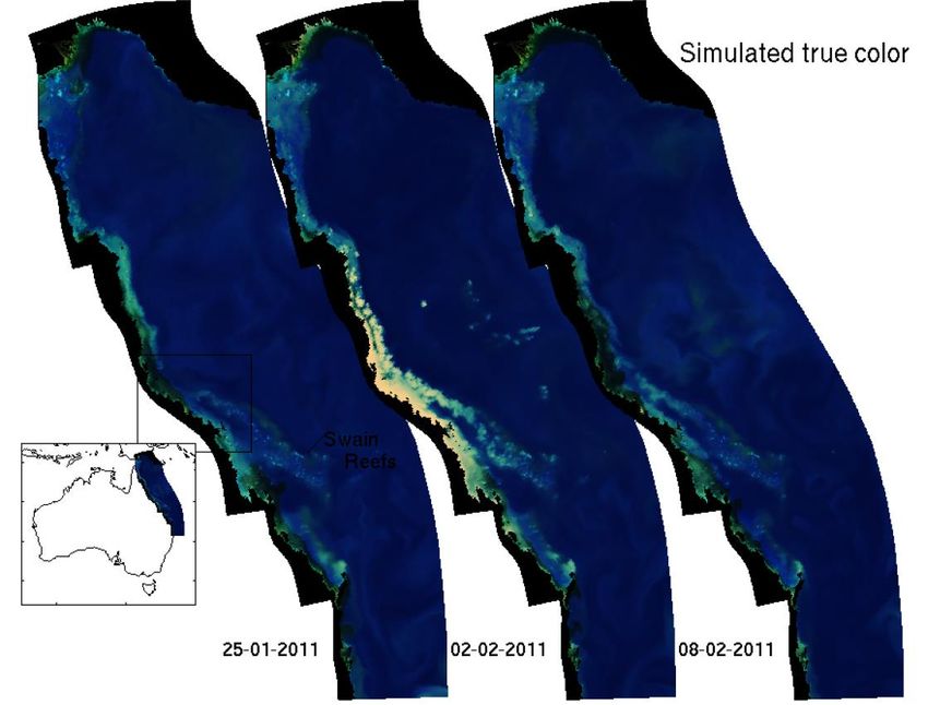
Figure 1.3 illustrates the continental scale modelling capability developed as part of eReefs. It shows
the result of modelling of the Reef area the week before cyclone Yasi, during the cyclone and the
week after. The impacts of the cyclone in terms of the amount of suspended particulates in the water
is clear. It is worth noting that that turbulence would be impossible to see using satellite observations
due to the cloud cover during the cyclone.
FIGURE 1.3 RESULTS OF EREEFS MODEL RUNS
Note:
SOURCE: CSIRO
The eReefs project has also delivered a model that can look at much smaller areas, such as individual
reefs, estuaries or bays. The Relocatable Estuary COastal Model (RECOM). RECOM utilises river and
catchment model data and ocean boundary conditions from regional models and BoM meteorological
data and can be used to examine biogeochemistry and or sediment parameters. Figure 1.4 provides
an example of the kind of information available from RECOM. It shows predicted chlorophyll
concentrations in an estuary and adjacent nearshore coastal region.
3 Reef 2050 Plan—Implementation Strategy, Australian and Queensland Governments, May 2015
6
EREEFS CASE STUDYFIGURE 1.4 EXAMPLE OF THE OUTPUT FROM RECOM
SOURCE: CSIRO
The eReefs project has developed a new framework for bringing together data products and services
from disparate data providers. This work to develop the interoperability of many different data sources
is essential for the generation of model outputs and visual products. CSIRO’s research is also helping
to progress the national and international discussion around how to achieve the aim of “Linked Open
Data”. The eReefs approach has resulted in the development of a collection of “Data Provider Nodes”
(DPNs) and a “Data Brokering Layer” (DBL), which provide a structured method for describing and
connecting data services. To achieve this, CSIRO developed a formal ontology4 – the Data Provider
Node Ontology (DPN-O) – and Data Provider Node definitions were created to sit on top of collections
of data services. These DPN definitions are then registered in the DBL, which is then exposed via an
Application Programming Interface (API). This approach allows multiple clients to connect to the
information in a modular, flexible way, enabling the use of a large variety of tools (e.g. models,
analysis tools, visualisations, etc.) to all connect via a single discovery point.
Figure 1.5 presents a very high level schematic view of the eReefs architecture. Multiple Data
Provider Nodes (DPNs), which are described using the Data Provider Node Ontology (DPN-O) and
collated through the Data Brokering Layer (DBL), which links to an API which can be accessed by
users to discover data products and services contained within individual DPNs.
4In computer and information science, an ontology is a formal naming and definition of the types, properties, and interrelationships of the
entities that really or fundamentally exist for a particular domain of discourse. An ontology compartmentalizes the variables needed for some
set of computations and establishes the relationships between them.
7
EREEFS CASE STUDYFIGURE 1.5 SCHEMATIC DIAGRAM OF THE EREEFS INFORMATION PLATFORM
Visualisation Analysis
Other client tools
portals dashboards
Data Brokering Layer
Data Provider 1 Data Provider 2 Data Provider 3
SOURCE: CSIRO
An eReefs visualisation portal was developed to allow access to the various outputs of the eReefs
information system in a visual and intuitive manner. The portal allows users to discover, visualise,
interrogate and extract data from various eReefs products. Currently, the visualisation portal allows
access to the CSIRO hydrodynamic model outputs (4km and 1km), the CSIRO Biogeochemical model
outputs (4km and 1km) and the BoM Ocean Colour data. It will soon incorporate data from the
Queensland Government, including river flows and catchment model outputs. Users can overlay
various data products on a mapping interface and interrogate the data in various ways. Currently,
users can add markers to the map which provides the user with data from each layer. This means that
data from different data providers, different variables or even different dates or depths from the same
data products can be viewed simultaneously. In addition, users can draw a line through the data to
generate a graph of data for each layer along that line. Additional user tools are nearing completion,
including advanced charting tools, a depth profile tool and data download functionality.
Figure 1.6 illustrates the kind of information that the eReefs visualisation portal can provide to users.
8
EREEFS CASE STUDYFIGURE 1.6 EREEFS VISUALISATION PLATFORM
SOURCE: CSIRO
The tools developed as part of this project are accessible via the web. Users around the globe will be
able to access comprehensive information about the conditions of the Reef in real-time on their laptop,
tablet or mobile. Users will be able to see the effects of storms, cyclones and floods on reef water
quality. The data collected can also be downloaded by researchers for use in their own research.
Hydrodynamic models can be used to develop customised products such as sailing forecasts and tidal
information to assist port and shipping operations, as well as enabling forecasts of hazards such as
jellyfish blooms and aiding emergency responses.
1.3.1 Publications
CSIRO’s research for the eReefs project has led to more than 45 publications, including 17 in peer-
reviewed journals, 14 conference papers or abstracts and 6 reports. Some examples are listed below:
— Mongin, M., M. E. Baird, B. Tilbrook, R. Matear, A. Lenton, M. Herzfeld, K. A. Wild-Allen, J. Skerratt,
N. Margvelashvili, B. Robson, C. M. Duarte, M. S. M. Gustafsson, P. J. Ralph and A. D. L. Steven
2016. The exposure of the Great Barrier Reef to ocean acidification. Nature Communications 7:
10732.
— Baird, M. E., N. Cherukuru, E. M. Jones, N. Margvelashvili, M. Mongin, K. Oubelkheir, P. J. Ralph, F.
Rizwi, B. Robson, T. Schroeder, J. Skerratt, A. D. L. Steven and K. A. Wild-Allen (2016). Remote-
sensing reflectance and true colour produced by a coupled hydrodynamic, optical, sediment,
biogeochemical model of the Great Barrier Reef, Australia: comparison with remotely-sensed data.
Environmental Modelling and Software Journal 78: 79-96.
— Herzfeld, M. and P. A. Gillibrand (2015). Active open boundary forcing using dual relaxation time-
scales in downscaled ocean models. Ocean Modelling 89: 71-83.
— Herzfeld, M. (2015). Methods for freshwater riverine input into regional ocean models. Ocean
Modelling 90: 1-15.
— Jones, E. M., M. A. Doblin, R. Matear and E. King (2015). Assessing and evaluating the ocean-colour
footprint of a regional observing system. Journal of Marine Systems 143: 49-61.
— Mongin, M. and M. Baird (2014). The impact of photosynthesis, calcification and water circulation on
carbon chemistry variability above a coral reef: a modelling study. Ecological Modelling 284: 19-34.
9
EREEFS CASE STUDY1.3.2 Innovation and commercialisation
Even though work on this project is still underway, the level of take up of the technology they have
developed is pleasing. The indications are that CSIRO’s ‘route to market’ approach of providing open
access to the platform they have developed is proving to be successful. The marine water quality
dashboard developed by BoM is one example, the development of RECOM and the contract with
Chile are examples of how others also see considerable value in the outputs of CSIRO’s research.
The eReefs project is delivering an information archive which includes products from in-situ
monitoring, satellite remote sensing and environmental modelling. Notably, these data products are
being delivered not only as downloadable data, but also as data services. This enables third parties
from around the world to build customised tools and interfaces that make use of this data in novel and
innovative ways, whether that be to create an application for a mobile device or a text based report.
CSIRO believes that the data infrastructure and the visualisation framework for modelling capabilities
such as RECOM are innovative and world leading.
1.4 Status of Outcomes and Impacts
There are already a number of users of the eReef models, including:
— The Great Barrier Reef Marine Park Authority
— The Queensland government
— The Bureau of Meteorology (and the users of its on line marine water quality dashboard)
The latter provides an online marine water quality dashboard that enables users to access to a range
of water quality indicators for the Reef, using near real-time data.5
There has also been interest in eReefs outputs by the insurance sector and electricity utilities. The
aquaculture sector are also likely to find the models useful for their business as it can be used to map
how an aquaculture facility could impact on water quality. This information would need to be provided
to authorities if a discharge license was being sought. Obtaining such information by conventional in
situ monitoring could cost an order of magnitude more than obtaining from the model. Tourism and
port operators are other potential users of the output from eReefs.
The models developed by eReefs can be applied around the globe. However they would first need to
be calibrated and verified using local information. In fact, CSIRO has already negotiated an agreement
with Chile to create a similar model for their coast region to help them protect the sustainability of their
salmon breeding program (see Box 1.1). While the agreement with Chile is likely to generate income
for CSIRO, we have not sought to quantify that benefit at this stage.
BOX 1.1 THE ACUA PACIFICO AGREEMENT
Acua Pacifico is a project to be undertaken for the Chilean government to develop an integrated sanitary and
environment information system for the Salmon aquaculture industry in the Patagonian region. Acua Pacifico
will utilise much of the philosophy, architecture, data, modelling and visualisation tools developed under
eReefs.
SOURCE: CSIRO
The eReefs project will generate economic, social and environmental impacts. The research will
significantly transform reef management, protection and assist in the long-term preservation of the
Great Barrier Reef. The eReefs project will:
— Build an ongoing comprehensive coastal information system for all of Australia, enabling improved
environmental decision-making.
— Increase Australia’s long-term knowledge of coastal trends and marine ecosystems, and the effects of
environmental trends on the Reef and surrounding marine ecosystem.
5 http://www.bom.gov.au/marinewaterquality/
10
EREEFS CASE STUDY— Provide vital tools, like the Marine Quality Dashboard, for decision-makers across the entire spectrum,
from the paddock to the reef.
— Enable customised products such as sailing forecasts and tidal information to assist port and shipping
operations.
— Enabling forward planning, reporting and emergency response preparation.
— Assist tourism through the use of social and economic data relating to populations, tourism trends,
and forecasts of sea state conditions and hazards such as jellyfish blooms.
The benefits of this project are likely to be considerable. Below we briefly discuss the potential
economic, social and environmental outcomes and impacts of the eReefs project.
1.4.1 Economic outcomes and impacts
As noted in Section 1.1.2, the GBR generates significant economic activity. As can be seen from
Table 1.2, the direct expenditure, value added and employment in four sectors has significant links to
the health of the reef.
TABLE 1.2 ECONOMIC CONTRIBUTION OF THE GBR
Sector Direct expenditure ($m) Value–added ($m) Employment (FTE)
Tourism 6,401.6 5,175.6 64,336
Recreation 332.4 243.9 2,785
Commercial fishing 192.5 160.3 975
Scientific research & 106.1 98.0 881
management
Totals 7,041.5 5,677.8 68,987
SOURCE: ECONOMIC CONTRIBUTION OF THE GREAT BARRIER REEF, GREAT BARRIER REEF MARINE PARK AUTHORITY, TOWNSVILLE, DELOITTE
ACCESS ECONOMICS, 2013.
The tools delivered by the eReefs project will help inform public policy decisions designed to protect
the health of the Reef. The Federal Government has estimated that around $2 billion is likely to be
spent by state and commonwealth governments on protection, management and research into the
reef over the coming decade.
The Federal Government has already committed $140 million to the Reef Trust, which will invest in
projects to improve water quality and coastal habitat as well as tackling crown-of-thorns starfish. The
Queensland Government has pledged a further $100 million over five years to be spent on projects to
protect the reef.
The use of tested and validated models instead of in situ testing could provide significant savings for
proponents of aquaculture projects seeking approvals for their projects. Aquaculture is a rapidly
growing industry. The value of Australian aquaculture production increased by around 25 per cent
between 2004–05 and 2012–13 to just over $1 billion. In 2012–13 aquaculture products comprised 43
per cent of Australian seafood production by value and 35 per cent by weight. The Food and
Agriculture Organization of the United Nations (FAO) has predicted that by 2018, farmed fish
production will exceed wild fisheries production for human consumption, and that by 2021 more than
half of the fish consumed globally will be produced by aquaculture.6
Other potential economic benefits flowing from the eReefs project include helping ports operate more
effectively and helping to prevent ships running aground. The costs of groundings can be
considerable. For example, the cost of restoring the Reef in the Douglas Shoal area where the
Chinese carrier Shen Neng 1 ran aground in April 2010 has been estimated to be $50 million (largely
the cost of removing the anti-fouling paint left on the Reef).7
6 http://www.agriculture.gov.au/fisheries/aquaculture/the_aquaculture_industry_in_australia?wasRedirectedByModule=true
7 The paint contains a banned substance called tributyltin, known as TBT.
11
EREEFS CASE STUDY1.4.2 Social outcomes and impacts
The main social outcomes arise from the improved ability of visitors to the Reef to increase their
enjoyment of the natural environment offered by the Reef and the ability of recreational fishermen to
continue to fish in a sustainable manner in permitted regions of the Reef. Another potential benefit
might be an improved search and rescue capability, which could shorten the time to find persons who
have suffered a mishap at sea and improve the likelihood of a better outcome.
Protecting employment will help to create more resilient regional communities. ACIL Allen has not
sought to assign a value to these impacts.
1.4.3 Environmental outcomes and impacts
An improved understanding of water quality and the health of the Reef coupled with a clearer picture
of the direct and indirect impacts of on land activity on the Reef will help policy makers design and
implement more effective and efficient policies and programs to reduce the likelihood of serious
environmental damage to the Reef. This in turn will lead to improvements in the water quality on the
Reef and improved marine bioecosystems.
ACIL Allen has not sought to assign a value to these impacts.
1.4.4 Counterfactual
In the absence of CSIRO, research on managing and protecting the Great Barrier Reef would still
have been undertaken, but in coming to these decisions the various governments involved would have
sought advice from other researchers in either universities or the private sector. However, neither
universities nor the private sector would have yielded the diverse and multidisciplinary range of
resources and capabilities that CSIRO was able to quickly mobilise. In particular, the modelling and
decision support capabilities that are unique to CSIRO, and have been developed over a long period
of time, which were essential to the success of the eReefs project.
Prior to the eReefs project monitoring of the Great Barrier Reef was inadequate. The disaggregated
and sparse data available in the absence of CSIRO’s research would not have been as useful for
informing decision making. The 2015 Queensland audit office report on catchment monitoring,
modelling and validation found these to be less than satisfactory.
The number of research organisations with the necessary marine science skills is relatively limited in
Australia. The main alternative agency available is Australian Institute of Marine Science (AIMS),
Australia’s tropical marine research agency. AIMS has research expertise, particularly in monitoring
and ecological responses, and some modelling capability. However, during the early stages of
research which formed the basis of what is now eReefs, it became clear that AIMS would struggle to
realise this project on their own, and that a collaborative effort represented the best chance nationally
to deliver an operational receiving waters model.
1.4.5 Attribution
The eReefs project was a collaborative one with a large number of groups contributing their expertise
or cash support for the work undertaken. However, over ninety per cent of the research for this project
was done by CSIRO. ACIL Allen believes that without the breadth and scale of CSIRO’s scientific
expertise the delivery of the results would, at best, have been significantly delay or, at worst, not
delivered at all.
The concept of the eReefs models was jointly developed by CSIRO and the GBRF. However, CSIRO
portfolio of skills played an important role in providing all the project participants with the necessary
confidence that the desired results could be delivered. This was essential to ensure that the
participants were all willing to make the relatively significant investments needed to carry out the
project.
Based on the above considerations, ACIL Allen has conservatively attributed 75 per cent of the
benefits derived from the eReefs project to CSIRO.
12
EREEFS CASE STUDY1.4.6 Adoption
The models developed by the eReef project are still being developed and refined. However, the
demand for them from a number of users is already very strong and adoption is likely to be rapid. The
Queensland Government has asked the CSIRO to use the regional models to inform the development
of the next generation of water quality targets and guideline values. The Queensland Government
recognises the value of eReefs. The Director of Landscape Sciences, Queensland Department of
Science, Information Technology, Innovation and the Arts has stated that:
...through eReefs we are actually able to build a better platform … so that we can understand from the
terrestrial, from the catchment side, through the estuaries and then out to the reef, (and create) one
integrated modelling tool.8
The CSIRO’s success in negotiating an agreement to create a similar model for Chile is a sign that the
outputs of the research are likely to be of considerable interest around the world.
The Bureau of Meteorology has, of course, already operationalised the outputs of eReefs in its on-line
marine water quality dashboard. The web site allows users to access to a range of water quality
indicators for the Reef, using near real-time data.
1.5 Assessment of impacts
1.5.1 Impacts to date
The models developed are already in use by the Great Barrier Reef Marine Park Authority, the
Queensland government and the Bureau of Meteorology. The first two use the information to inform
their decision making. The latter provides an online marine water quality dashboard that enables users
to access to a range of water quality indicators for the Reef, using near real-time data.
The eReefs project will generate economic, social and environmental impacts. The value of tourism
and fisheries alone on the Great Barrier Reef is considerable. Even a small increase in Australia’s
ability to protect that economic activity will have significant economic benefit.
1.5.2 Potential future impacts
Work in ongoing to make use of new and higher resolution data from earth observation satellites. The
results of this work is expected to be progressively operationalised. The ‘open access’ approach being
adopted by CSIRO as their route to market should help ensure that there is rapid uptake of the
outputs of the research. Researchers working on the eReefs project have reported considerable
interest from applications developers to make use of the framework developed by CSIRO.
The fact that one overseas jurisdictions has already contracted to make use of the research outputs
also bodes well for the prospect of future income streams being generated by this project.
1.5.3 Cost Benefit Analysis
Costs
As shown previously in Section 1.1.2, by 2017 CSIRO will have contributed a total of $7.85 million in
in-kind support to the eReefs project ($3.22 million in 2012 to 2013 for phase 1, $4.19 in 2014 to 2015
for phase 2 and $0.44 million in 2016 to 2017 for phase 3).
Benefits
Greater returns to government investment in the protection and management of the GBR
As discussed previously in Section 1.4.1, the Federal Government has estimated that $2 billion is
likely to be spent by state and commonwealth governments on the protection and management of,
and research into, the Great Barrier Reef over the coming decade. Assuming that this investment will,
8Dr Paul Lawrence, Director Landscape Sciences, Queensland Department of Science, Information Technology, Innovation and the Arts,
EReefs video, https://vimeo.com/148551957
13
EREEFS CASE STUDYin the absence of the eReefs project, generate benefits of $1.50 for each dollar spent, the expected
net benefits of the investment will total $1 billion over the next 10 years.9
Suppose that the tools delivered by the eReefs project will positively inform public policy decisions
affecting the $2 billion worth of investments in the protection and management of the reef so that the
net benefits generated with be increased by 5 per cent. This translates into additional benefits of $50
million over 10 years (or an average of $5 million a year).
Reduction in the likelihood of catastrophic events that will impact tourism
Table 1.2 shows that the reef generates in excess of $5 billion a year in tourism value added.
Suppose that the knowledge generated and disseminated by the eReefs project lowers the probability
of a catastrophic event that reduces the economic value of tourism in the GBR by 50 per cent in any
given year. If the probability of such an event is lowered by 0.5 percentage points (say, from 1 per
cent to 0.5 per cent10), the expected benefit that will be generated will be approximately $12.5 million
per year. In essence, the investment in the eReefs project is akin to purchasing an insurance policy to
help protect the Reef and the national income it generates.
Enhanced growth of aquaculture in the GBR
According to the Deloitte Access Economics report cited in Section 1.4.1, the gross value of
aquaculture in the regions around the GBR was $69.6 million in 2010-11. Assuming that the ratio of
value added to gross value product is the same for aquaculture and other types of commercial fishing,
the value added of aquaculture in those regions was approximately $33.4 million in 2010-11.
Section 1.4.1 argued that the use of tested and validated models developed as a result of the eReefs
project instead of in-situ testing could help facilitate project approvals for proponents of new
aquaculture projects along the Queensland coast. If we assume that this results in annual growth in
the value of aquaculture production in regions around the GBR that is 2 percentage points higher than
it would otherwise have been, the benefits generated would be around $0.7 million a year.
Reduced incidence of damage from shipping incidents
More than 9,600 ship voyages were recorded in the Reef between 2012 and 2013, and 3,947
individual ships called in at Reef ports in 2012.11 At the current growth rate of 4.8 per cent per annum,
the projected increase in ship numbers calling into these ports will exceed 10,000 by 2032.
According to the GBRMPA, more than 600 shipping incidents were recorded in the region between
1987 and 2009, an average of approximately 30 incidents a year. Suppose that the information
generated and disseminated by the eReefs project reduces the number of incidents by 5 per cent a
year and that the average cost of each incident is $200,000, then the annual benefit is estimated to be
$0.3 million a year.
Assessment of costs versus benefits
Using 2015-16 as the base year of the cost-benefit analysis and adjusting project costs for CPI
inflation, the present value of CSIRO’s project costs is approximately $8.38 million in 2015-16 dollars
under a 7 per cent real discount rate.
Taking into account the time lags associated with the diffusion of knowledge generated by the eReefs
project, the total benefits of the project is expected to reach $18.5 million per year by 2018-19. Using
the previously discussed attribution rate of 75 per cent, the annual benefit that can be attributed to
CSIRO is estimated to be $13.9 million per year from 2018-19 onwards (see Figure 1.7). The present
value of this stream of benefits to 2025-26 is approximately $89.2 million in 2015-16 dollars under a 7
per cent real discount rate.
9 Given the enormous economic value of the GBR and its vulnerability to multiple threats, government investment in its protection and
management is likely to deliver comparatively high returns. ACIL Allen therefore views the assumption of a benefit-cost ratio of 1.5 for such
investment to be on the conservative side.
10 The October 2012 report by the Australian Institute of Marine Science which declared that coral cover had declined by 50% in just 27
years suggests that a 1 per cent probability of catastrophic damage to the Reef may be relatively conservative.
11 Great Barrier Reef Marine Park Authority, Great Barrier Reef Outlook Report 2014
14
EREEFS CASE STUDYFIGURE 1.7 PROJECT BENEFITS, 2015-16 TO 2025-26 (2015-16 DOLLARS)
16
Millions
14
12
10
8
6
4
2
0
FY16 FY17 FY18 FY19 FY20 FY21 FY22 FY23 FY24 FY25 FY26
Reduced incidence of damage from shipping incidents
Enhanced growth of aquaculture
Reduction in likelihood of adverse events impacting tourism
Greater returns to investment in reef management and protection
SOURCE: ACIL ALLEN CONSULTING
The net present value (NPV) of the eReefs project to CSIRO, the difference between the present
value of project costs and benefits, is therefore $80.8 million in 2015-16 dollars under a 7 per cent real
discount rate. The benefit-cost ratio (BCR), the ratio of the present value of project benefits to the
present value of project costs, is 10.6.
Sensitivity analysis
ACIL Allen undertook sensitivity analysis to test the robustness of the CBA results to changes in
assumptions and uncertain parameters. The results of the sensitivity analysis are shown in Table 1.3.
TABLE 1.3 RESULTS OF SENSITIVITY ANALYSIS
Variable Central Low High BCR (low BCR (high
assumption assumption assumption assumption) assumption)
BCR of government investment 1.5 1.2 1.8 8.9 12.4
in GBR research
Improvement in net benefits of 5% 2.5% 7.5% 9.2 12.1
GBR research due to eReefs
Reduction in tourism value due 50% 25% 75% 7.0 14.2
to a catastrophic event
Reduction in probability of a 0.5% 0.25% 0.75% 7.0 14.2
catastrophic event due to eReefs
Increase in annual value of 2% 1% 3% 10.4 10.8
aquaculture due to eReefs
Cost per shipping incident in the $200,000 $50,000 $350,000 10.5 10.8
GBR
Reduction in shipping incidents 5% 2.5% 7.5% 10.6 10.7
enabled by eReefs
Benefits of eReefs attributable to 75% 50% 100% 7.1 14.2
CSIRO
SOURCE: ACIL ALLEN CONSULTING
The last two columns of the table show the effects of varying the key assumptions (and their
associated parameter values) one at a time. As mentioned above, the BCR is 10.6 under the central
15
EREEFS CASE STUDYcase (that is, with each variable assumed to have the parameter value shown in the second column of
the table). The BCR ranges from 7.0 to 14.2 in the cases explored in the sensitivity analysis.
1.5.4 CSIRO’s role as an Innovation Catalyst
The backbone of the eReefs information platform is an innovative information architecture that
enables data from a range of sources to contribute to a central Data Brokering Layer (DBL). The
information held within the DBL can be accessed by application developers or end-users.
An important aspect of the framework that has been developed by CSIRO is the ease with which it
enables users to access to the models and datasets within the DBL. This has been done through a
visualisation portal that allows users to search for data, discover the available services and data from
multiple data providers and visualise that data in maps and charts. The visualisation techniques
developed by the eReefs project are innovative and world leading.
The outputs of the project are already being used to inform decision making by the Queensland
Government. The ‘open access’ approach being adopted by CSIRO as their route to market should
ensure that there is rapid uptake of the outputs. The fact that one overseas jurisdictions has already
contracted to make use of the research outputs also bodes well for the prospect of future income
streams being generated by this project.
16
EREEFS CASE STUDYYou can also read