SANBI tools for Georeferencing, Species distributions and extensions for ArcView 3.x and other applications
←
→
Page content transcription
If your browser does not render page correctly, please read the page content below
SANBI tools for Georeferencing,
   Species distributions and
  extensions for ArcView 3.x
    and other applications
Updated 12 October 2015, originally prepared 24 November 2009,
              Les Powrie, l.powrie@sanbi.org.za
Page 2   of 37

C:\SANBI\SANBIDistrnDatabases\sanbi-extensions-arcview-3x-other-v01.docx   Page 2
Page 3   of 37

                          SANBI tools for Georeferencing,
                             Species distributions and
                            extensions for ArcView 3.x
                              and other applications
                         Updated 12 October 2015, originally prepared 24 November 2009,
                                       Les Powrie, l.powrie@sanbi.org.za

Cite as:
Powrie, L.W. 2015. SANBI tools for Georeferencing, Species distributions and extensions for ArcView
       3.x and other applications. Unpublished guide. South African National Biodiversity Institute,
       Cape Town. Downloaded from www.sanbi.org on dd MMM yyyy [specify date downloaded].
       Internet. 37 pp. http://www.sanbi.org/sites/default/files/documents/documents/ sanbi-
       extensions-arcview-3x-other-v01.pdf

Contents
  General notes about the extensions:........................................................................................................ 4
  Search for and display places by name ..................................................................................................... 4
     References for Gazetteer ...................................................................................................................... 4
     ArcView extension ................................................................................................................................ 4
  Display distributions of species, genus, family, species for a 1:50 000 map, collector and batch (list
  of taxa) ...................................................................................................................................................... 8
     Sources and References for species distributions ................................................................................ 8
     ArcView extension ................................................................................................................................ 9
  SANBI Extensions forArcView 3.x............................................................................................................ 12
     Toggle display of themes .................................................................................................................... 12
     Utilities to zoom to selected themes .................................................................................................. 17
     Various utilities created while working on the vegetation map of South Africa ................................ 18
     Table of Contents utilities ................................................................................................................... 18
     Utilities to print or export view or layout with date stamp ................................................................ 19
     Add latitude and longitude, area and ID to tables .............................................................................. 21
     Copy and paste theme legend ............................................................................................................ 22
     Database of taxon information and for capturing other distributions data ....................................... 22
     Databases for personal location data ................................................................................................. 25
     Table of menu items, buttons, tools, and shortcut keys used in extensions...................................... 28
  Extensions from other sources that I find particularly useful................................................................. 31
     Easy click features for working with themes (EZ-Click from ESRI site) ............................................... 31
     Set of basic theme tools (1st Tools from ESRI site).............................................................................. 32
     Named extent (from ESRI site)............................................................................................................ 33
     COS explode multipart shapes (from ESRI site) .................................................................................. 34
  Setting up an ODBC driver connection ................................................................................................... 34
  Preparing and Installing Distributions and Gazetteer extensions .......................................................... 35
     Step 1 .................................................................................................................................................. 35
     Step 2 .................................................................................................................................................. 35
     Step 3 .................................................................................................................................................. 36
     Step 4 .................................................................................................................................................. 36

C:\SANBI\SANBIDistrnDatabases\sanbi-extensions-arcview-3x-other-v01.docx                                                                                              Page 3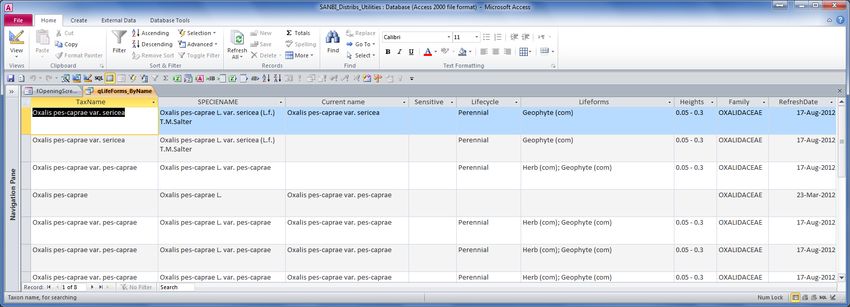
Page 4 of 37
Step 5 .................................................................................................................................................. 37
General notes about the extensions:
The set of extensions was originally used and developed with ArcView 3.x in mind, but has become
increasingly adapted for use with Google Maps, Google Earth, Quantum GIS (QGIS), Diva GIS or
ArcGIS. The databases are being developed to make them more usable with these other mapping
tools, for exporting results of searches for species distributions and place names, or for using
coordinates from those tools. Some of the ArcView extensions are not needed in ArcGIS and QGIS
and so they have not been developed further.
ArcView menu items can usually be activated by using the shortcuts indicated by underlined letters.
For example, Alt-F S will select the File menu and then the Save menu item. This will work unless
there is more than one possible menu or item matching the keystroke.
Where the menu shows a shortcut (a keystroke such as Ctrl+F8 or Shift+F2)
the user can use the keystroke or the menu item (or button if there is a button). Sometimes a key
shortcut (e.g. ctrl-F9) may clash between extensions. In this case, one extension can be unloaded, or
else the menu commands should be used rather than the shortcut as long as both extensions are
loaded.
A lot of these extensions may not be immediately useful to you, but the code may give you an idea
of how to solve your own problems if you are into programming. I am indebted to the very clever
Avenue programmers out in Cyberspace from whom I borrowed some or many ideas for these
extensions (those who did not encrypt their code ).
Search for and display places by name
A set of MS Access databases with place names for South Africa and some neighbouring territories.
The databases contain tools for finding place names, and for adding new places or names to the
gazetteer. Users are encouraged to regularly send to SANBI new names that they have added to
their installation of the gazetteer so that the new information can be added to the main gazetteer.
MSAccess database C:\SANBI\SANBIDistrnDatabases\SANBI_Gazetteer_Personal_v5.mdb
MSAccess database C:\SANBI\SANBIDistrnDatabases\SANBI_Gazetteer_v5.mdb
MSAccess database
C:\SANBI\SANBIDistrnDatabases\SANBI_GazetteerTables_Personal_v5.mdb
Sources for Gazetteer
Description Precision Records Citation
Digitised off Map of the Eastern Frontier of the ½-2 km http://www.ngi.gov.za/
Cape Colony 1856
Names captured from various scale maps - cent ¼º 73278 Leistner, O.A., Morris, J.W. 1976. South African Place Names. Annals of the Cape Provincial Museums. Volume 12.
centroid of ¼º grid grid Published jointly by the Cape Provincial Museums at the Albany Musem, Grahamstown. South Africa. 565 pp.
Gazetteer from CDSM - names on maps ½-2 km 46256 http://www.ngi.gov.za/
Combined cadastral shapefiles from cent farm 77949 http://egis.environment.gov.za/Download.aspx?m=25&catid=8
ENPAT2001
Demarcation Board Plc_Name.dbf ½-2 km 11851 http://www.demarcation.org.za/
Demarcation Board PlName.dbf ½-2 km 9685 http://www.demarcation.org.za/
Demarcation Board parent farm names cent farm 87482 http://www.demarcation.org.za/
(sa_parent_clk.dbf)
Built_up.shp from 1:500 000 map data cent 3073 http://www.ngi.gov.za/
urban
Built_pts.shp from 1:500 000 map data ½-2 km 977 http://www.ngi.gov.za/
VEGM2006 protected areas cent 2325 http://www.sanbi.org/node/5605
C:\SANBI\SANBIDistrnDatabases\sanbi-extensions-arcview-3x-other-v01.docx Page 4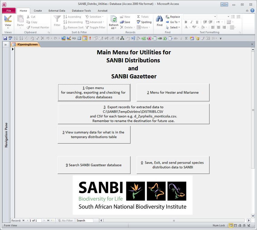
Page 5    of 37

                 Description                    Precision Records                                                      Citation
                                                rsrv/prk
Magisterial districts from 1:500 000 map data   5-10 km      376 http://www.ngi.gov.za/
Point from Zoo-historical Gazetteer for sn Af   ½-2 km      3104 Skead, C.J. 1973. Zoo-historical Gazetteer. Volume 10 of Annals of the Cape Provincial Museums. Published jointly
                                                                 by the Cape Provincial Museums at the Albany Museum. 259 pp.
Point from Zoo-historical Gazetteer for sn Af   ½-2 km      4456 Skead, C.J. 1973. Zoo-historical Gazetteer. Volume 10 of Annals of the Cape Provincial Museums. Published jointly
                                                                 by the Cape Provincial Museums at the Albany Museum. 259 pp.
SAGNS Official Database - downloaded 15 Sep ½-2 km         59290
2006
HSRC list from SAGNS website                    unknown
Gazetteer from NGI - names on 1:50 000 maps ½-2 km         80776 http://www.ngi.gov.za/
Acocks field notes/maps                         ½-2 km        24 http://volunteer.ala.org.au/project/list?mode=&q=safa
Digitised off topographical maps                ½-2 km        47 http://www.ngi.gov.za/
SG Railway points from 1:500 000 data           ½-2 km      2633 http://www.ngi.gov.za/
Digitised off 50k topographical maps            ½-2 km       196 http://www.ngi.gov.za/
Digitised off 250k topographical maps           ½-2 km        73 http://www.ngi.gov.za/
Digitised off 500k topographical maps           ½-2 km        58 http://www.ngi.gov.za/
Digitised off 500k 1900-1919 topographical      ½-2 km         8 http://www.ngi.gov.za/
map
Village names from Google Earth                 ½-2 km      7408
Data from delegate to TREES-3 workshop          ½-2 km     10574
Other source not mentioned above                unknown       23
Place names other than cadasters from ENPAT ½-2 km                  http://egis.environment.gov.za/Download.aspx?m=25&catid=8
Various place names from UCT georeferencing 700m           49558
section, source unknown.
Gazetteer for South Africa downloaded from      250m
DIVA-GIS website April 2012
Tapson & Poynton Management aid from            ½-2 km
Forestry Herbarium
Digitised off Pre 1900 topographical map        ½-2 km              http://www.ngi.gov.za/
Digitised off online maps (e.g. Google Maps)    ½-2 km
Assisted by information from Google search,     ½-2 km
e.g. GBIF
Obtained from Google Maps                       ½-2 km              https://www.google.co.za/maps?source=tldsi&hl=en
Obtained from Google Eerth                      ½-2 km              http://www.google.com/earth/
Digitised off 1800s map (e.g. 1895 Map Of       ½-2 km              http://www.ngi.gov.za/
Cape Of Good Hope Colony, 1895)
CAPE-GOOD_HOPE_ED0_1853.tif                     ½-2 km              http://www.ngi.gov.za/
Digitised of other map source                   ½-2 km         2
Point from personal communication of            ½-2 km         8
someone with personal knowledge
GPS locations added by user                     0-30 m
no coordinates - AFRICAN PLACENAMES from        None
via MapStudiosWebsite.xls
To delete                                       Del
Source given in PRECIS gazetteer, captured      cent ¼º     8238 Leistner, O.A., Morris, J.W. 1976. South African Place Names. Annals of the Cape Provincial Museums. Volume 12.
from various scale maps - centroid of ¼º grid   grid             Published jointly by the Cape Provincial Museums at the Albany Musem, Grahamstown. South Africa. 565 pp.
Source given in PRECIS gazetteer, captured      cent ¼º    43294 Leistner, O.A., Morris, J.W. 1976. South African Place Names. Annals of the Cape Provincial Museums. Volume 12.
from various scale maps - centroid of ¼º grid   grid             Published jointly by the Cape Provincial Museums at the Albany Musem, Grahamstown. South Africa. 565 pp.
Source given in PRECIS gazetteer, captured      cent ¼º     7015 Leistner, O.A., Morris, J.W. 1976. South African Place Names. Annals of the Cape Provincial Museums. Volume 12.
from various scale maps - centroid of ¼º grid   grid             Published jointly by the Cape Provincial Museums at the Albany Musem, Grahamstown. South Africa. 565 pp.
Source given in PRECIS gazetteer, captured      cent ¼º     1513 Leistner, O.A., Morris, J.W. 1976. South African Place Names. Annals of the Cape Provincial Museums. Volume 12.
from various scale maps - centroid of ¼º grid   grid             Published jointly by the Cape Provincial Museums at the Albany Musem, Grahamstown. South Africa. 565 pp.
Source given in PRECIS gazetteer, captured      cent ¼º      794 Leistner, O.A., Morris, J.W. 1976. South African Place Names. Annals of the Cape Provincial Museums. Volume 12.
from various scale maps - centroid of ¼º grid   grid             Published jointly by the Cape Provincial Museums at the Albany Musem, Grahamstown. South Africa. 565 pp.
Source given in PRECIS gazetteer, captured      cent ¼º     1439 Leistner, O.A., Morris, J.W. 1976. South African Place Names. Annals of the Cape Provincial Museums. Volume 12.
from various scale maps - centroid of ¼º grid   grid             Published jointly by the Cape Provincial Museums at the Albany Musem, Grahamstown. South Africa. 565 pp.
Source given in PRECIS gazetteer, captured      cent ¼º     2946 Leistner, O.A., Morris, J.W. 1976. South African Place Names. Annals of the Cape Provincial Museums. Volume 12.
from various scale maps - centroid of ¼º grid   grid             Published jointly by the Cape Provincial Museums at the Albany Musem, Grahamstown. South Africa. 565 pp.
Source given in PRECIS gazetteer, captured      cent ¼º      370 Leistner, O.A., Morris, J.W. 1976. South African Place Names. Annals of the Cape Provincial Museums. Volume 12.
from various scale maps - centroid of ¼º grid   grid             Published jointly by the Cape Provincial Museums at the Albany Musem, Grahamstown. South Africa. 565 pp.
Source given in PRECIS gazetteer, captured      cent ¼º       67 Leistner, O.A., Morris, J.W. 1976. South African Place Names. Annals of the Cape Provincial Museums. Volume 12.
from various scale maps - centroid of ¼º grid   grid             Published jointly by the Cape Provincial Museums at the Albany Musem, Grahamstown. South Africa. 565 pp.
Source given in PRECIS gazetteer, captured      cent ¼º       15 Leistner, O.A., Morris, J.W. 1976. South African Place Names. Annals of the Cape Provincial Museums. Volume 12.
from various scale maps - centroid of ¼º grid   grid             Published jointly by the Cape Provincial Museums at the Albany Musem, Grahamstown. South Africa. 565 pp.
Source given in PRECIS gazetteer, captured      cent ¼º      168 Leistner, O.A., Morris, J.W. 1976. South African Place Names. Annals of the Cape Provincial Museums. Volume 12.
from various scale maps - centroid of ¼º grid   grid             Published jointly by the Cape Provincial Museums at the Albany Musem, Grahamstown. South Africa. 565 pp.
Source given in PRECIS gazetteer, captured      cent ¼º       39 Leistner, O.A., Morris, J.W. 1976. South African Place Names. Annals of the Cape Provincial Museums. Volume 12.
from various scale maps - centroid of ¼º grid   grid             Published jointly by the Cape Provincial Museums at the Albany Musem, Grahamstown. South Africa. 565 pp.
Source given in PRECIS gazetteer, captured      cent ¼º       21 Leistner, O.A., Morris, J.W. 1976. South African Place Names. Annals of the Cape Provincial Museums. Volume 12.
from various scale maps - centroid of ¼º grid   grid             Published jointly by the Cape Provincial Museums at the Albany Musem, Grahamstown. South Africa. 565 pp.
Source given in PRECIS gazetteer, captured      cent ¼º       39 Leistner, O.A., Morris, J.W. 1976. South African Place Names. Annals of the Cape Provincial Museums. Volume 12.
from various scale maps - centroid of ¼º grid   grid             Published jointly by the Cape Provincial Museums at the Albany Musem, Grahamstown. South Africa. 565 pp.
Source given in PRECIS gazetteer, captured      cent ¼º     1406 Leistner, O.A., Morris, J.W. 1976. South African Place Names. Annals of the Cape Provincial Museums. Volume 12.
from various scale maps - centroid of ¼º grid   grid             Published jointly by the Cape Provincial Museums at the Albany Musem, Grahamstown. South Africa. 565 pp.

C:\SANBI\SANBIDistrnDatabases\sanbi-extensions-arcview-3x-other-v01.docx                                                                                                             Page 5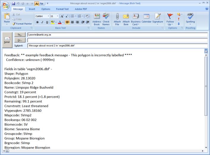
Page 6 of 37
Description Precision Records Citation
Source given in PRECIS gazetteer, captured cent ¼º 308 Leistner, O.A., Morris, J.W. 1976. South African Place Names. Annals of the Cape Provincial Museums. Volume 12.
from various scale maps - centroid of ¼º grid grid Published jointly by the Cape Provincial Museums at the Albany Musem, Grahamstown. South Africa. 565 pp.
Source given in PRECIS gazetteer, captured cent ¼º Leistner, O.A., Morris, J.W. 1976. South African Place Names. Annals of the Cape Provincial Museums. Volume 12.
from various scale maps - centroid of ¼º grid grid Published jointly by the Cape Provincial Museums at the Albany Musem, Grahamstown. South Africa. 565 pp.
Source given in PRECIS gazetteer, captured cent ¼º 18 Leistner, O.A., Morris, J.W. 1976. South African Place Names. Annals of the Cape Provincial Museums. Volume 12.
from various scale maps - centroid of ¼º grid grid Published jointly by the Cape Provincial Museums at the Albany Musem, Grahamstown. South Africa. 565 pp.
Source given in PRECIS gazetteer, captured cent ¼º 4112 Leistner, O.A., Morris, J.W. 1976. South African Place Names. Annals of the Cape Provincial Museums. Volume 12.
from various scale maps - centroid of ¼º grid grid Published jointly by the Cape Provincial Museums at the Albany Musem, Grahamstown. South Africa. 565 pp.
Source given in PRECIS gazetteer, captured cent ¼º 669 Leistner, O.A., Morris, J.W. 1976. South African Place Names. Annals of the Cape Provincial Museums. Volume 12.
from various scale maps - centroid of ¼º grid grid Published jointly by the Cape Provincial Museums at the Albany Musem, Grahamstown. South Africa. 565 pp.
Source given in PRECIS gazetteer, captured cent ¼º 23 Leistner, O.A., Morris, J.W. 1976. South African Place Names. Annals of the Cape Provincial Museums. Volume 12.
from various scale maps - centroid of ¼º grid grid Published jointly by the Cape Provincial Museums at the Albany Musem, Grahamstown. South Africa. 565 pp.
Source given in PRECIS gazetteer, captured cent ¼º Leistner, O.A., Morris, J.W. 1976. South African Place Names. Annals of the Cape Provincial Museums. Volume 12.
from various scale maps - centroid of ¼º grid grid Published jointly by the Cape Provincial Museums at the Albany Musem, Grahamstown. South Africa. 565 pp.
Source given in PRECIS gazetteer, captured cent ¼º 1 Leistner, O.A., Morris, J.W. 1976. South African Place Names. Annals of the Cape Provincial Museums. Volume 12.
from various scale maps - centroid of ¼º grid grid Published jointly by the Cape Provincial Museums at the Albany Musem, Grahamstown. South Africa. 565 pp.
Source given in PRECIS gazetteer, captured cent ¼º 321 Leistner, O.A., Morris, J.W. 1976. South African Place Names. Annals of the Cape Provincial Museums. Volume 12.
from various scale maps - centroid of ¼º grid grid Published jointly by the Cape Provincial Museums at the Albany Musem, Grahamstown. South Africa. 565 pp.
Source given in PRECIS gazetteer, captured cent ¼º 185 Leistner, O.A., Morris, J.W. 1976. South African Place Names. Annals of the Cape Provincial Museums. Volume 12.
from various scale maps - centroid of ¼º grid grid Published jointly by the Cape Provincial Museums at the Albany Musem, Grahamstown. South Africa. 565 pp.
Source given in PRECIS gazetteer, captured cent ¼º 164 Leistner, O.A., Morris, J.W. 1976. South African Place Names. Annals of the Cape Provincial Museums. Volume 12.
from various scale maps - centroid of ¼º grid grid Published jointly by the Cape Provincial Museums at the Albany Musem, Grahamstown. South Africa. 565 pp.
Source given in PRECIS gazetteer, captured cent ¼º 3 Leistner, O.A., Morris, J.W. 1976. South African Place Names. Annals of the Cape Provincial Museums. Volume 12.
from various scale maps - centroid of ¼º grid grid Published jointly by the Cape Provincial Museums at the Albany Musem, Grahamstown. South Africa. 565 pp.
Source given in PRECIS gazetteer, captured cent ¼º 1 Leistner, O.A., Morris, J.W. 1976. South African Place Names. Annals of the Cape Provincial Museums. Volume 12.
from various scale maps - centroid of ¼º grid grid Published jointly by the Cape Provincial Museums at the Albany Musem, Grahamstown. South Africa. 565 pp.
Source given in PRECIS gazetteer, captured cent ¼º 17 Leistner, O.A., Morris, J.W. 1976. South African Place Names. Annals of the Cape Provincial Museums. Volume 12.
from various scale maps - centroid of ¼º grid grid Published jointly by the Cape Provincial Museums at the Albany Musem, Grahamstown. South Africa. 565 pp.
Source given in PRECIS gazetteer, captured cent ¼º 1 Leistner, O.A., Morris, J.W. 1976. South African Place Names. Annals of the Cape Provincial Museums. Volume 12.
from various scale maps - centroid of ¼º grid grid Published jointly by the Cape Provincial Museums at the Albany Musem, Grahamstown. South Africa. 565 pp.
Source given in PRECIS gazetteer, captured cent ¼º 4 Leistner, O.A., Morris, J.W. 1976. South African Place Names. Annals of the Cape Provincial Museums. Volume 12.
from various scale maps - centroid of ¼º grid grid Published jointly by the Cape Provincial Museums at the Albany Musem, Grahamstown. South Africa. 565 pp.
Source given in PRECIS gazetteer, captured cent ¼º 1 Leistner, O.A., Morris, J.W. 1976. South African Place Names. Annals of the Cape Provincial Museums. Volume 12.
from various scale maps - centroid of ¼º grid grid Published jointly by the Cape Provincial Museums at the Albany Musem, Grahamstown. South Africa. 565 pp.
Source given in PRECIS gazetteer, captured cent ¼º 2 Leistner, O.A., Morris, J.W. 1976. South African Place Names. Annals of the Cape Provincial Museums. Volume 12.
from various scale maps - centroid of ¼º grid grid Published jointly by the Cape Provincial Museums at the Albany Musem, Grahamstown. South Africa. 565 pp.
Source given in PRECIS gazetteer, captured cent ¼º 1 Leistner, O.A., Morris, J.W. 1976. South African Place Names. Annals of the Cape Provincial Museums. Volume 12.
from various scale maps - centroid of ¼º grid grid Published jointly by the Cape Provincial Museums at the Albany Musem, Grahamstown. South Africa. 565 pp.
Source given in PRECIS gazetteer, captured cent ¼º 42 Leistner, O.A., Morris, J.W. 1976. South African Place Names. Annals of the Cape Provincial Museums. Volume 12.
from various scale maps - centroid of ¼º grid grid Published jointly by the Cape Provincial Museums at the Albany Musem, Grahamstown. South Africa. 565 pp.
Total of 531 520 records, but with at least 20% duplicates of the same place from different sources.
ArcView extension
_0_SANBI_Gazetteer_v5p02.avx
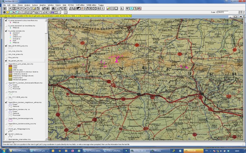
Description : Adds a Gazetteer button and menu to a view for the user to search for a place name as
specified (all names starting with the search term), creates a point shapefile, and adds it to the view.
Searches a compilation of data from many sources of place names and localities.
Requires:
A view vSANBI
folder C:\SANBI\TempDstrbtns
ODBC driver with ODBC connection 'Ms Access Database'.
Preferably also VEGMAP data (e.g. in c:\vegm2006_cd\data).
Batch file C:\SANBI\SANBIDistrnDatabases\delGZTR.bat
Metadata file C:\SANBI\SANBIDistrnDatabases\SANBI_Gazetteer.shp.xml
Projection file C:\SANBI\SANBIDistrnDatabases\SpeciesDistributionMetadata.prj
Recommended:
_1_LWP_toggledisplays_for_av_v8p18.avx (or latest version) that toggles the display on/off
for digital maps from National Geospatial Informatics e.g.
C:\SANBI\SANBIDistrnDatabases\sanbi-extensions-arcview-3x-other-v01.docx Page 6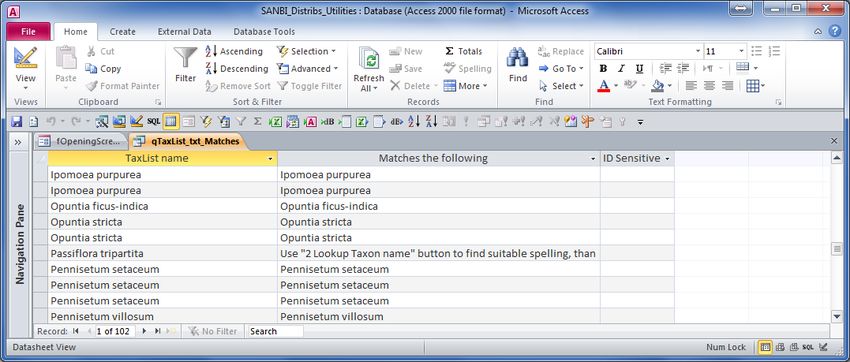
Page 7 of 37
o WGS2628AD.TIF, WGS3318BC.TIF (older 1:50 000 map series)
o wgs_2628.tif, wgs_3318.tif (older 1:250 000 map series)
o nn_Gauteng_TOPO-UNION_OF_SOUTH-AFRICA_IRR_1936.tif (1:500 000 irrigation
map series from about 1936
o Topo_500k_SnAfr_nnnn_nnnn set (South Africa, Namibia, Botswana, Zimbabwe,
Mozambique, Swaziland, Lesotho
o Acocks field maps (TOPO-UNION_OF_SOUTH-AFRICA_IRR_1936 with sample sites
marked)
Also available are
o South Africa Imperial 1:250 000 maps from about 1900-1919
o Union of South Africa 1:1 000 000 maps from 1923
o Union of South Africa 1:1 500 000 maps from 1938
o Various maps of Rhodesia, Botswana, Mozambique, Angola-Congo, etc.
o CAPE-COLONY-EASTERN-FRONTIER-ED0_1856
o CAPE-TOWN_ED0_1884
o CAPE_COLONY_1901
o CAPE-PENINSULA_ED0_1909
o CAPE-GOOD_HOPE_ED0_1853
o CAPE-GOOD_HOPE_ED0_1853_Inset
o Cape-1822-Burchell
o Map of Cape of Good Hope Colony 1895
From within a view
Click to search for a place name. For example, ‘zyv’ will give places starting with ‘zyv’ such as
ZYVERGAT, ZYVERFONTEIN, Zyverbult.
SANBI_utilities
From within a table
Click to search for a place name. For example, ‘zyv’ will give places starting with ‘zyv’ such as
ZYVERGAT, ZYVERFONTEIN, Zyverbult.
SANBI_utilities
C:\SANBI\SANBIDistrnDatabases\sanbi-extensions-arcview-3x-other-v01.docx Page 7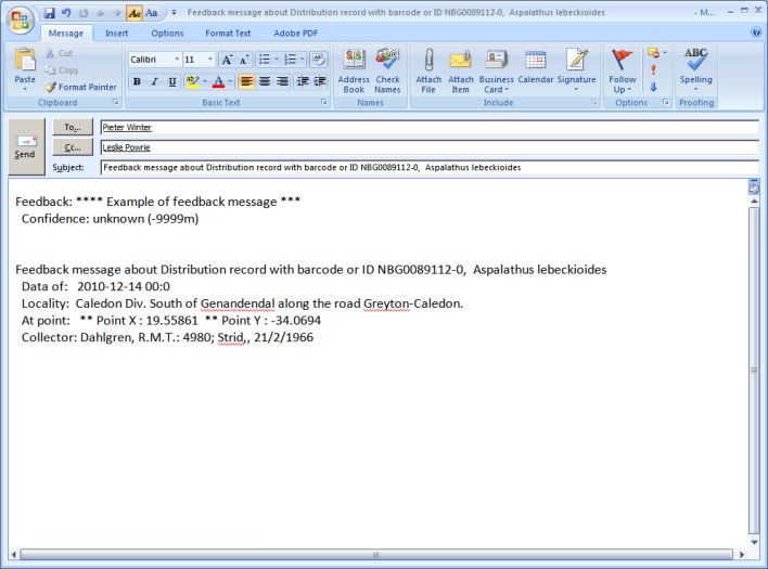
Page 8 of 37
Display distributions of species, genus, family, species for a 1:50 000 map,
collector and batch (list of taxa)
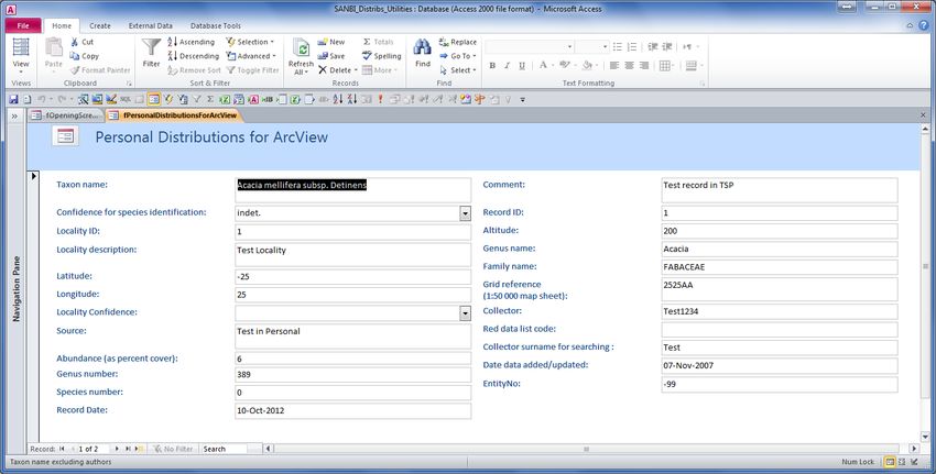
A set of MS Access databases with species distribution data that can be viewed using GIS. Data from
the SANBI databases are included, and personal distribution data can be added that will then be
included in results from searches.
Search by binomial: To search by binomial for the distribution of taxa.
Search by Family: To search for the distribution of a family.
Search by Genus: To search for the distribution of a genus.
Search by QDS GridRef: To search for all taxa located in a 1:50 000 (quarter degree) map sheet.
Search by Collector: To search for the records associated with a collector or observer. This enables
one to track the movements of a collector which is a useful technique for georeferencing
specimens with uncertain localities.
Search by batch for binomials: This uses a file C:\SANBI\SANBIDistrnDatabases\TaxList.txt that
contains a list of binomials such as
Acacia karroo
Protea caffra
Acacia caffra
Search by batch for grid references: This uses C:\SANBI\SANBIDistrnDatabases\GridRef.txt)
MSAccess databases
o C:\SANBI\SANBIDistrnDatabases\SANBI_Distribs_Utilities.mdb
o C:\SANBI\SANBIDistrnDatabases\SANBI_Distribs_2000_v12.mdb
o C:\SANBI\SANBIDistrnDatabases\SANBI_Distribs_Personal_v10.mdb
o C:\SANBI\SANBIDistrnDatabases\SANBI_Distribs_Personal_Table.mdb
o C:\SANBI\SANBIDistrnDatabases\SANBI_Distribs_PRECIS_v10.mdb
o C:\SANBI\SANBIDistrnDatabases\SANBI_Distribs_Acocks_v10.mdb
o C:\SANBI\SANBIDistrnDatabases\SANBI_Distribs_PAP_v10.mdb
o C:\SANBI\SANBIDistrnDatabases\SANBI_Distribs_TSP_v10.mdb
o C:\SANBI\SANBIDistrnDatabases\SANBI_Distribs_Other_v10.mdb
o C:\SANBI\SANBIDistrnDatabases\SANBI_Distribs_NVD_v10.mdb
o C:\SANBI\SANBIDistrnDatabases\SANBI_Distribs_SAPIA_v10.mdb
Sources and References for species distributions
Species distribution data are extracted from various databases available in SANBI to combine readily
available distribution information in a single shapefile. Other data can be included as more
databases become available.
The data sources are described as follows:
PRECIS
Data taken from PRECIS (National Herbarium Pretoria (PRE) Computerized Information
System) database. There are over 1 125 000 records available. Only 5% of the records
have a locality confidence of less than about 1 km, and 9% more precise than a quarter
degree grid (1:50 000 map sheet). Only presence data.
o Germishuizen, G. & Meyer, N.L. (eds) 2003 Plants of southern Africa: an annotated checklist. Strelitzia
14. National Botanical Institute, Pretoria
o Magill, R.E., Russell, G.E., Morris, J.W. & Gonsalves, P. 1983. PRECIS, the Botanical Research
Institute herbarium data bank. Bothalia 14: 481-495.
ACKDAT
Data recorded by John Acocks during forty years of field surveying throughout most of
South Africa. There are over 277 000 records available. The precision of georeferencing is
about 1.6 km, and for many sample sites absences can be inferred with a low degree of
confidence.
C:\SANBI\SANBIDistrnDatabases\sanbi-extensions-arcview-3x-other-v01.docx Page 8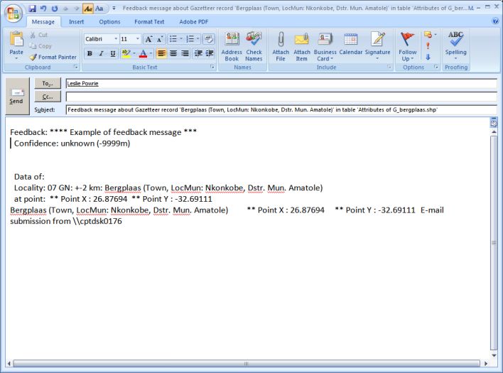
Page 9 of 37
o Rutherford, M.C., Powrie, L.W., Midgley, G.F. 2003. ACKDAT: A digital spatial database of
distributions of South African plant species and species assemblages. South African Journal of Botany
(2003), 69:99-104
PAP
A systematic search undertaken by citizen scientists for members of the family Proteaceae
at the most likely localities in South Africa. There are over 265 000 records available. The
precision of georeferencing is about 0.5 km, and absences can be inferred with a very high
degree of confidence because there was a determined effort to record presence if a
species of Proteaceae were at the locality.
o Rebelo, A. 1991. Protea Atlas Manual: instruction booklet to the Protea Atlas Project. National
Botanical Institute, Kirstenbosch. http://protea.worldonline.co.za/
NVD
A compilation of vegetation survey plot data from most parts of South Africa. There are
over 524 000 records available. Some 62% of the records have a locality confidence of
less than about 1 km, and all included in the distributions database are more precise than
a quarter degree grid (1:50 000 map sheet).
o Rutherford MC, Mucina L, Powrie LW. 2012. The South African National Vegetation Database: History,
development, applications, problems and future. South African Journal of Science 2012;108(1/2), Art.
#629, 8 pages. http://dx.doi.org/10.4102/sajs.v108i1/2.629
o Mucina, L., Bredenkamp, G.J., Hoare, D.B. & McDonald, D.J. 2000. A national vegetation database for
South Africa. South African Journal of Science 96: 497, 498.
CREW/TSP/MSB/ISEP
The Threatened Species Programme, funded by the Royal Norwegian Embassy from
2004-2009, is a monitoring and reporting programme that is divided into plant and animal
units. The plant component comprises the Red List of South African plants and the
Custodians of Rare and Endangered Wildflowers (CREW) programme. CREW is a
programme that involves volunteers from the public in the monitoring and conservation of
South Africa's threatened plants. CREW volunteers contribute significantly by each
focusing on a small area of the country and monitoring the plant species of conservation
concern of that area. There are over 24 000 records available. Presence only data, with
precision of georeferencing about 0.01 km.
MSB (Millennium Seed Bank) Partnership is an international ex situ plant conservation
project aiming to collect and conserve seeds from 25% of the world’s orthodox plant
species by 2020. There are over 71 records available.
ISEP (Information System for Endangered Plants) programme of CapeNature. There are
over 2 100 records available.
o CREW/TSP/ISEP (CapeNature Information System for Endangered Plants) – citation needed.
o http://www.sanbi.org/programmes/threats/custodians-rare-and-endangered-wildflowers-crew-
programme
o http://www.sanbi.org/programmes/threats/millennium-seed-bank-project
o http://www.sanbi.org/programmes/threats/threatened-species-programme
SAPIA
Southern African Plant Invaders Atlas (SAPIA). Under the leadership of Lesley Henderson,
SAPIA is an important resource for with a collection of computerized information on the
distribution, abundance and habitat types of naturalized and invasive alien plants in the
southern African region. There are over 64 000 records available. About 57% are more
precise than a quarter degree grid (1:50 000 map sheet)of which some 20% of the records
have a locality confidence of less than about 1 km. Some absences can probably be
inferred when observations were made with the objective to survey all aliens at a specific
place.
o Henderson, L. 1999. The Southern African Plant Invaders Atlas (SAPIA) and its contribution to
biological weed control. African Entomology Memoir No. 1: 159–163
ArcView extension
_0_SANBI_Distribtns_v11p03.avx
C:\SANBI\SANBIDistrnDatabases\sanbi-extensions-arcview-3x-other-v01.docx Page 9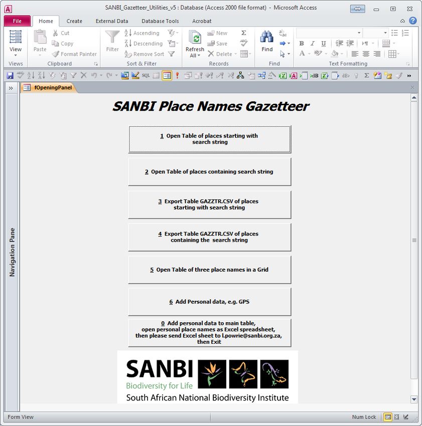
Page 10 of 37
Description: Adds a menu with items for displaying distributions of species (binomial), genus, family,
collector, map sheet (e.g. 1:50 000. A button is also added to a view for the user to search for a
taxon distribution. A search can be done by entering the start a word. For example, to search for a
binomial, enter the start of the genus name and species name. If more than one match is found then
a list is given and the user selects one or more binomials the list of all genus and species names
starting with the search term. A point shapefile is created for each result, and this is added to the
view. For example, ‘asp’ for genus and ‘lin’ for species will give taxa starting with ‘asp’ and ‘lin’ such
as Aspalathus linearis, Aspalathus linearifolia, and their synonyms, e.g. Aspalathus cognata, Lebeckia
linearis. Data are combined from 6 different databases.
Where more than one name is found a list is presented and the user can select all names, or more
than one name. Just click and drag down the list instead of clicking a single name, or hold shift and
click more than one name.
Requires:
A view vSANBI
Batch file C:\SANBI\SANBIDistrnDatabases\deldstrb.bat
Metadata file C:\SANBI\SANBIDistrnDatabases\SpeciesDistributionMetadata.shp.xml
Projection file C:\SANBI\SANBIDistrnDatabases\SpeciesDistributionMetadata.prj
folder C:\SANBI\TempDstrbtns
ODBC driver with ODBC connection 'Ms Access Database'.
It is recommended that one also uses the VEGMAP data (e.g. in c:\vegm2006_cd\data)
accompanying the book Mucina, L. & Rutherford, M.C. (eds) 2006. The Vegetation of South Africa,
Lesotho and Swaziland. Strelitzia 19. South African National Biodiversity Institute, Pretoria.
The extension is set up specifically for a PC name.
The extension requires a SQL connection to an ODBC connection 'Ms Access Database'. If it does not
work try adding 'Ms Access 95 Database' and/or 'Ms Access 97 Database'
From within a view
Click to search by entering the start of a genus name and species name for the distribution of
taxa. For example, ‘asp’ for genus and ‘lin’ for species will give taxa starting with ‘asp’ and ‘lin’ such
as Aspalathus linearis, Aspalathus linearifolia, and their synonyms, e.g. Aspalathus cognata, Lebeckia
linearis.
Keystroke that run a utility are indicated at the right of the menu bar (e.g. Ctrl+D). The keystroke
offers a shortcut to run the command. Sometimes the keystroke does not work because there is a
clash with the same keystroke for some other command. In such a case the item should be selected
directly from the menu.
SANBI_utilities
C:\SANBI\SANBIDistrnDatabases\sanbi-extensions-arcview-3x-other-v01.docx Page 1Page 11 of 37
SANBI distributions – search by binomial: To search by binomial for the distribution of taxa.
SANBI distributions – search by Family: To search for the distribution of a family.
SANBI distributions – search by Genus: To search for the distribution of a genus.
SANBI distributions – search by QDS GridRef: To search for all taxa located in a 1:50 000 (quarter
degree) map sheet.
SANBI distributions – search by Collector: To search for the records associated with a collector or
observer. This enables one to track the movements of a collector which may help to
georeference a specimen with uncertain locality.
SANBI distributions – for a batch of binomials: This uses a file (defaults to
C:\SANBI\SANBIDistrnDatabases\ TaxList.txt) that contains a list of binomials such as
Acacia karroo
Protea caffra
Acacia caffra
Shapefiles are then created for taxa matching those binomials.
Open a database of Taxa and Life Forms, and Specimens without co-ordinates: Enables searching for
life forms etc., and taxon names for copy and paste. Also displays PRECIS records with no
georeferencing that can be important, for example for assigning something like endemic
status to a species.
Open the folder containing GIS shapefiles created in the searches for distributions and place names.
From within a table
Click the button to search by binomial for the distribution of taxa.
SANBI_utilities
C:\SANBI\SANBIDistrnDatabases\sanbi-extensions-arcview-3x-other-v01.docx Page 1Page 12 of 37
SANBI distributions – search by binomial: To search by binomial for the distribution of taxa.
SANBI distributions – search by Family: To search for the distribution of a family.
SANBI distributions – search by Genus: To search for the distribution of a genus.
SANBI distributions – search by QDS GridRef: To search for all taxa located in a 1:50 000 (quarter
degree) map sheet.
SANBI distributions – search by Collector: To search for the records associated with a collector or
observer. This enables one to track the movements of a collector which may help to
georeference a specimen with uncertain locality.
SANBI distributions – for a batch of binomials: This uses a file (defaults to
C:\SANBI\SANBIDistrnDatabases\ TaxList.txt) that contains a list of binomials such as
Acacia karroo
Protea caffra
Acacia caffra
Shapefiles are then created for taxa matching those binomials.
Open a database of Taxa and Life Forms, and Specimens without co-ordinates: Enables searching for
life forms etc., and taxon names for copy and paste. Also displays PRECIS records with no
georeferencing that can be important, for example for assigning something like endemic
status to a species.
SANBI Extensions forArcView 3.x
Toggle display of themes
_1_LWP_toggledisplays_for_av_v8p15.avx
Adds ToggLe menu and Shift-Fx features to toggle displays of scanned map image themes,
VEGM2006 data (Mucina, L. & Rutherford, M.C. (eds) 2006. The Vegetation of South Africa, Lesotho
and Swaziland. Strelitzia 19. South African National Biodiversity Institute, Pretoria.), and other data.
Controls display of VEGMAP themes and scanned map or satellite images if loaded.
C:\SANBI\SANBIDistrnDatabases\sanbi-extensions-arcview-3x-other-v01.docx Page 1Page 13 of 37
From within a view
Button , Tools , , Menu
These tools and menus will control a view vSANBI.
ToggLe
Toggle the display of themes:
VEGMAP borders (national and provincial) if loaded with default theme name
vegm2006o_borders.shp
VEGMAP topographical data (roads, rivers, places, major parks, etc. as on the printed map) if
loaded with default theme names
Scanned images (1:50 000 (e.g. WGS2228DD.TIF), 1:250 000 (e.g. wgs_2428.tif), 1:500 000
(Topographical maps dated about 1936 for old routes and place names, e.g.
rsa_500k_topo_01_dd_1936.tif) if loaded with appropriate default theme names)
VEGMAP vegetation types if loaded with default theme name vegm2006.shp.
VEGMAP vegetation types can be simply switched on and off and the theme also activated for
querying its attributes
C:\SANBI\SANBIDistrnDatabases\sanbi-extensions-arcview-3x-other-v01.docx Page 1Page 14 of 37
Satellite images (EarthSat (e.g. S35-E018_ul.tif in NaturalVue) or SPOT5 (e.g. 2621D.TIF) if loaded
with appropriate default theme names)
Zoom to the appropriate scale for the displayed topographical map
Zoom to full extent of South Africa
In the case of the scanned maps, the appropriate scale for displaying the map can also be quickly
selected. For example, Shift-F7 toggles the 1:50 000 maps, and F7 zooms to a scale where the
1:50 000 map detail is legible.
Buttons:
Zoom to full extent of South Africa
Tools:
Activate to click on a position in the view to get Lat & Long (e.g. -22.6409 28.6155)
coordinates to paste directly into adjacent Latitude and Longitude fields in a spreadsheet or
database. Copy the coordinates by pressing Ctrl-C, then click Cancel or press ESC.
Alternatively, instead of copying the presented coordinates, type a message and select OK. The
message is added to the file C:\SANBI\SANBIDistrnDatabases\WriteCursorPoint.txt. The option is
then given to open the file in Notepad to Cut/Copy the information to a database, e-mail, etc.
Example text
Acocks red dot near Atherton, Point: 23.7897 -29.0181
A tool that allows you to click on a feature and write the attribute information to file
C:\SANBI\SANBIDistrnDatabases\identify.txt, with the option to open the file. Example text
R:\MakeLWPExtensions\getmenusandbuttonsfordocumentation.apr
vSANBI
Mon Dec 07 13:13:30 2009
Feature: 3881, Vegm2006.shp - Schmidtsdrif Thornveld
** Point X : 23.7921 Y : -28.9338
- Shape: Polygon
- Polysqkm: 3475.46110
- Bookcode: SVk 6
- Name: Schmidtsdrif Thornveld
- Constrgt: 16%
- Protctd: 0.2%
- Remaining: 87%
- Cnsrvtnstt: Least threatened
- Vtypesqkm: 5032.75490
- Mapcode: SVk6
- Booksequ: 06 05 006
- Biomecode: SV
- Biome: Savanna Biome
- Groupcode: SVk
- Group: Eastern Kalahari Bushveld Bioregion
- Brgncode: SVk
- Bioregion: Eastern Kalahari Bushveld Bioregion
- Vegtypeid: 9284
- Biomeid: 7
- Groupid: 8
- Brgnid: 8
- Polygonid: 3882
- Prtctnstts: Hardly protected
- Pdfname: pdf\SVk_6_Schmidtsdrif_Thornveld.pdf
- Toclegend: 06 05 006 SVk 6 Schmidtsdrif Thornveld
- Legend: SVk 6 Schmidtsdrif Thornveld
==========================================================
From within a table
These tools and menus will control a view vSANBI.
ToggLe
C:\SANBI\SANBIDistrnDatabases\sanbi-extensions-arcview-3x-other-v01.docx Page 1Page 15 of 37
VEGMAP borders (national and provincial)
VEGMAP topographical data (roads, rivers, places, major parks, etc. as on the printed map)
Scanned images (1:50 000, 1:250 000, 1:500 000 (Acocks field maps dated about 1936 for old
routes and place names) if loaded with appropriate default theme names)
VEGMAP vegetation types
Satellite images (EarthSat or SPOT5 if loaded with appropriate default theme names)
Active themes
Zoom to the appropriate scale for the displayed topographical map
Zoom to full extent of South Africa
In the case of the scanned maps, the appropriate scale for displaying the map can also be quickly
selected. For example, Shift-F7 toggles the 1:50 000 maps, and F7 zooms to a scale where the
1:50 000 map detail is legible.
Buttons:
Zoom to full extent of South Africa
Tools:
Click the tool, then click on a record in the table. A dialog box will allow the user to enter a
message about that record, e.g. ‘Benfontein on 250k map. Suggest coordinates: 24.818 -28.8295.’
The note and information from the record are used to create an email that can be sent giving
feedback on the table in question.
C:\SANBI\SANBIDistrnDatabases\sanbi-extensions-arcview-3x-other-v01.docx Page 1Page 16 of 37
Click the tool, then click on a record in the table. A dialog box will allow the user to enter a
message about that record, e.g. ‘Benfontein on 250k map. Suggest coordinates: 24.818 -28.8295.’
The note and information from the record are written to a text file as
R:\MakeLWPExtensions\getmenusandbuttonsfordocumentation.apr
Attributes of D_oxalis pes-caprae var pes-caprae.shp
Mon Dec 07 17:54:06 2009
C:\SANBI\SANBIDistrnDatabases\sanbi-extensions-arcview-3x-other-v01.docx Page 1Page 17 of 37
- PRE0834088-0, Oxalis pes-caprae var. pes-caprae, Data of: 2009-09-01 00:0, Locality:
Benfontein; Koppie., at: ** Point X : 24.87500 ** Point Y : -28.8750, Note made: Mon Dec
07 17:54:31 2009 on \\cptltp0176
******* Note: Benfontein on 250k map. Suggest coordinates: 24.818 -28.8295
The last paragraph with the message can then be cut or pasted into a message, or the entire text
file can be sent to Les Powrie l.powrie@sanbi.org.za or Hester Steyn h.steyn@sanbi.org.za at
SANBI for updating records as appropriate. Hester will forward records for databases other than
PRECIS to the appropriate data manager.
Utilities to zoom to selected themes
_LWP_View_ZoomToSelected750_vegm2006_v1p7.avx
From within a view
Zoom to selected, but zoomed out scale 15 as opposed to the normal scale 1.1 for ‘Zoom to
selected’ to see the context of a small selected feature.
Click to centre the view on coordinates entered by the user. With matching menu item Pan to
coordinates specified by user.
Click to set default printer (e.g. printing to PDF), then the Layout to print (e.g. LPrintPDF), and
thereafter click themes to display, and click this button to print the specified document to the
specified printer.
Menu item under Edit, to subtract graphics (normally there, but this assigns the Ctrl-O key to the
function).
From within a table
Controls a view called vSANBI. Also gives control tips and help in the
Zoom to selected at the normal scale 1.1.
Zoom tight to selected at the scale 1 (fits display to selected feature).
Zoom to selected at scale 15 as opposed to the normal scale 1.1 for zoom to selected to see the
context of a small selected feature.
Zoom in.
Zoom out.
Zoom to previous extent.
LWP utilities
C:\SANBI\SANBIDistrnDatabases\sanbi-extensions-arcview-3x-other-v01.docx Page 1Page 18 of 37 Zoom to selected at the normal scale 1.1. Zoom tight to selected at the scale 1 (fits display to selected feature). Zoom to selected at scale 15 as opposed to the normal scale 1.1 for zoom to selected to see the context of a small selected feature. Zoom out. Zoom in. Zoom to previous extent. Various utilities created while working on the vegetation map of South Africa _1_LWP_Utlities_v1p01.avx Adds buttons to View for clipping one theme by another, or cutting one them by another. From within a view Clips one theme by a selected polygon theme, returning a new shapefile with the clipped features and their attributes. Splits polygons or polylines using selected graphics or selected features from polyline themes. Operates like the exisitng split line features tool in the view. Table of Contents utilities _LWP_View_HideShowLegendsEtc__v5p2.avx Adds menu items to View to select, deselect themes, LegendTextItem, Gen2Shp, Unembed script, etc. From within a view Find, activate and display a theme with name starting with the characters as entered. Toggle display of theme/s with names ending with ‘isplay’ and set active for promote or demote. Summarize a zone theme (point, line or polygon) by a grid in the view. It asks for the field by which to summarize, and the name of the table to create (file name and name in project window). LWP utilities C:\SANBI\SANBIDistrnDatabases\sanbi-extensions-arcview-3x-other-v01.docx Page 1
Page 19   of 37

Find, activate and display a theme with name starting with the characters as entered.

Add a theme (e.g. point, line, polygon) from a generate file (see help for details of generate files).

Create a generate file for a feature theme (e.g. point, line, polygon). This can be used to create
polygon from line or line from polygon, e.g. by using a word processor for adding or removing ‘Auto’
after feature ID.

Legend text for label allows the user to assign attribute item values to 'Text' field of legend ' that
correspond to the values of the item used for the 'Value' field. ' Works for joined (lookup table)
items too! If a one-to-many relationship exists between the value field and the ' text field, the first
value encountered will be used.

Removed - Create custom legend defines a unique legend for the vegmap (Mucina, L. & Rutherford,
M.C. (eds) 2006. The Vegetation of South Africa, Lesotho and Swaziland. Strelitzia 19. South African
National Biodiversity Institute, Pretoria.) from a dbf. Notes: Will not work with hatch.avp for some
reason. Depedencies: Needs a poly shape with a numerical id column and an associated dbf with all
of the legend settings.
Activate all image or grid themes in the view, or all themes.

Toggle display of active themes, or of all themes, or of all image themes.

From within a table

Utilities to print or export view or layout with date stamp
_LWP_View_Layout_Print_or_Export_v5p4.avx

Adds a button to the View button bar to export a layout as print, jpg, bmp or eps. Well, it actually
does a whole lot more.

Needs view vSANBI and layouts LViewOnly & LLegend.

From within a view
   Export or print the view. The user is prompted to enter text for a label to be created giving
details of project name and path, date of printout, etc. to help identify versions of maps (this
became necessary with the very many printouts of VEGMAP (Mucina, L. & Rutherford, M.C. (eds)
2006. The Vegetation of South Africa, Lesotho and Swaziland. Strelitzia 19. South African National
Biodiversity Institute, Pretoria.) so that I had some idea of the history behind a printout). The user is
then asked if the view is to be printed as well as exported. The user can also specify a resolution for
the JPEG. A file name and path can also be specified.

C:\SANBI\SANBIDistrnDatabases\sanbi-extensions-arcview-3x-other-v01.docx                                    Page 1
Page 20   of 37

Example of label:                                                  .

It also writes the label information to a file in the working directory, e.g.

        Demo 2
        23 Nov 2009, 15:12.
        R:\MakeLWPExtensions\getmenusandbuttonsfordocumentation.apr
        Work Dir.: $HOME\ Document: View1
        Demo 2 date
        $HOME\01_v_Demo_2_300dpi.jpg
    Print or export a layout from within a view. It reminds the user about things like isolines to be
displayed, no polygons selected giving different colours, codes switched on or off, sequence of
layers. The user then selects which layout to export. The result is similar to View print or export.

        Demo view - layout export
        23 Nov 2009, 15:22.
        R:\MakeLWPExtensions\getmenusandbuttonsfordocumentation.apr
         Work Dir.: $HOME\ Document: LLayout
        Demo view - layout export
        $HOME\01_v_l_Demo_view_-_layout_export_144dpi.jpg
    Export the view as a JPEG, simple and quick. Simple export, allows user to give file name and
select a path, and writes to a text file giving date, source, project, etc.

        23 Nov 2009 15:28
            file written:           $HOME\demo view to jpeg
            using:                  getmenusandbuttonsfordocumentation.apr
            with Working Directory: $HOME\
    View – export a layout as a JPEG. Exports the layout (lViewOnly) and legend (LLegend) to
u:\graphics. These are useful for inserting into PowerPoint. Writes to text file to identify source.

        23 Nov 2009 15:33 u:\graphics\LayoutAsJPEG
LWP utilities

                                Writes the view to a GeoJPEG that has a world file. This is about 96 dpi,
but is useful for adding as a theme to a view, or sending to someone who can add it as a theme in a
view. It can also be opened as a graphic. It is also useful for displaying on a palmtop with ArcPad. For
example I export a portion of a 1:50 000 map and add it to the palmtop.

From within a table
   Writes view vSANBI to GeoJPEG as above.

   Requires view vSANBI, layout LSANBI, table with field Taxon. Designed for use with a table (e.g.
‘TaxonList’) containing a list of taxa for which distribution maps are to be exported, but will work
with a record of any attribute table as it is selected using the tool. The table would contain a field
with the name ‘Taxon’ for use in the file name, such as the following .txt file.

        Taxon
        Acacia ataxacantha
        Acacia borleae

C:\SANBI\SANBIDistrnDatabases\sanbi-extensions-arcview-3x-other-v01.docx                                    Page 2
Page 21 of 37
The view vSANBI would contain a theme with records for each taxon name in table ‘TaxonList’. Open
the theme attribute table, activate the field containing the taxon names, then return to the table
‘TaxonList’, make the field Taxon active, and link the tables (Table | Link). It is recommended that a
suitable selection colour be selected in the project property (Window | 1 nameofproject.apr |
Project | Properties | Selection Color | and select a suitable colour, such as red or black). The theme
legend would typically be a solid marker and with transparent colour so that only selected points
become visible (with the selection colour) when a record is selected in table ‘TaxonList’.Test the link
with the button. Click names to observe the theme display change. Then when a record in table
‘TaxonList’ is clicked with this tool active, the records for the taxon in the theme are displayed,
and JPEG and GeoJPEG files are exported from vSANBI and LSANBI to the project Working Directory.
Make sure that distribution points from one taxon are cleared when a new taxon record is selected.
It might be necessary to have a copy of the same point theme at the bottom of the Table of Contents
in vSANBI that will force the view to refresh each time a new record is selected, otherwise previous
selection may not be replaced, but added to.
From within a layout
LWP utilities
Writes the Layout to a 330dpi JPEG.
Print or export the layout as above.
Export 300dpi JPEG of the layout.
Add latitude and longitude, area and ID to tables
_LWP_View_Table_LatLong_AreaHa_ID_v5p4.avx
Adds buttons to View for adding AreaHa, Lat/Long and ID to table.
From within a view
Adds two new fields named LWP_Ha to the table of the first active theme in the TOC and fills the
respective fields with the area in hectares. It uses [shape].return area in a projected view to give the
area for the selected polygons (or all polygons if no selection is defined) in a poly theme. It requires
an active polygon theme. This script does minimal error checking and assumes that there is an active
theme. If the theme is not in a projected view the user is advised to paste it into a projected view to
calculate the area.
Adds two new fields, named Long and Lat, to the table of the first active theme in the TOC and
fills the respective fields with the Long,Lat coordinates of the selected points (or all points if no
selection is defined) in a point theme. If instead the active theme is a polygon theme, then the
Long,Lat coordinates of the polygon centroid are calculated. If the theme is projected, the output
coordinates will also be projected. Requires an active point or polygon theme. This script does
minimal error checking and assumes that there is an active theme.
Adds a field to the table (user selects name for field) and inserts the unique ID for each record
into the field.
LWP utilities
C:\SANBI\SANBIDistrnDatabases\sanbi-extensions-arcview-3x-other-v01.docx Page 2Page 22 of 37 Copy and paste theme legend _Z_0_LWPpasteleg.avx Copies legends from one feature theme to another. Copy legend: Copies the legend of the active theme. Needs the shape class of this source theme, the symbolization fields, and the legend. Paste legend: Pastes a copied legend onto the active theme. For Single Symbol legends the target theme must be the same feature type as the source. For Unique Value the target theme must have the same field name and field type used for symbolization. If the field name is different, but the field type is the same the user can save the legend as an .avl file and load it for the other theme, and point it to the appropriate field. Database of taxon information and for capturing other distributions data From within ArcView one can Open a database with taxon information from PRECIS. You can also capture additional distribution data. C:\SANBI\SANBIDistrnDatabases\sanbi-extensions-arcview-3x-other-v01.docx Page 2
You can also read