EUMETSAT Prototype Satellite Data Cube - Methods Document - Release 1.0.2 EUMETSAT - EUMETSAT Training Zone
←
→
Page content transcription
If your browser does not render page correctly, please read the page content below
EUMETSAT Prototype Satellite Data
      Cube - Methods Document
                        Release 1.0.2

                         EUMETSAT

                            May 06, 2021
project-docs/methods-document
1.0.2, May 6, 2021
EUMETSAT Prototype Satellite Data Cube - Methods Document
LIST OF FIGURES
3.1 The case when using different grids with the anchor attribute: “pixel”. . . . . . . . . . . . . . . . 9
3.2 The case when using different grids with the attribute: “area”. . . . . . . . . . . . . . . . . . . . 9
4.1 Grid with data associated with the centre of cells (green) versus grid with data associated with a
vertex of the cells (blue). . . . . . . . . . . . . . . . . . . . . . . . . . . . . . . . . . . . . . . . 13
4.2 Example of the time coordinate defined in the CDS common data model. . . . . . . . . . . . . . . 14
iproject-docs/methods-document
1.0.2, May 6, 2021
EUMETSAT Prototype Satellite Data Cube - Methods Document
LIST OF TABLES
2.1 Applicable documents. . . . . . . . . . . . . . . . . . . . . . . . . . . . . . . . . . . . . . . . . 4
2.2 Reference documents. . . . . . . . . . . . . . . . . . . . . . . . . . . . . . . . . . . . . . . . . . 4
2.3 Items yet to be defined. . . . . . . . . . . . . . . . . . . . . . . . . . . . . . . . . . . . . . . . . 5
5.1 Input products details. . . . . . . . . . . . . . . . . . . . . . . . . . . . . . . . . . . . . . . . . . 18
6.1 Proposed standard names. . . . . . . . . . . . . . . . . . . . . . . . . . . . . . . . . . . . . . . . 22
iiiproject-docs/methods-document
1.0.2, May 6, 2021
EUMETSAT Prototype Satellite Data Cube - Methods Document
CONTENTS
1 Document Information 1
1.1 Document Change Record . . . . . . . . . . . . . . . . . . . . . . . . . . . . . . . . . . . . . . 1
2 Introduction 3
2.1 Purpose . . . . . . . . . . . . . . . . . . . . . . . . . . . . . . . . . . . . . . . . . . . . . . . . 3
2.2 Scope . . . . . . . . . . . . . . . . . . . . . . . . . . . . . . . . . . . . . . . . . . . . . . . . . 3
2.3 Applicable Documents . . . . . . . . . . . . . . . . . . . . . . . . . . . . . . . . . . . . . . . . 4
2.4 Reference Documents . . . . . . . . . . . . . . . . . . . . . . . . . . . . . . . . . . . . . . . . 4
2.5 List of TBDs . . . . . . . . . . . . . . . . . . . . . . . . . . . . . . . . . . . . . . . . . . . . . 5
3 Problem Analysis 7
3.1 Overview . . . . . . . . . . . . . . . . . . . . . . . . . . . . . . . . . . . . . . . . . . . . . . . 7
3.2 Spatial Resolution . . . . . . . . . . . . . . . . . . . . . . . . . . . . . . . . . . . . . . . . . . 7
3.2.1 Common geographic reference system . . . . . . . . . . . . . . . . . . . . . . . . . . . 7
3.2.2 Regridding . . . . . . . . . . . . . . . . . . . . . . . . . . . . . . . . . . . . . . . . . 8
3.2.3 Pixel-wise error measures and quality flags . . . . . . . . . . . . . . . . . . . . . . . . 8
3.2.4 Pixel center . . . . . . . . . . . . . . . . . . . . . . . . . . . . . . . . . . . . . . . . . 8
3.3 Temporal coordinate . . . . . . . . . . . . . . . . . . . . . . . . . . . . . . . . . . . . . . . . . 8
3.3.1 Reference time . . . . . . . . . . . . . . . . . . . . . . . . . . . . . . . . . . . . . . . 10
3.3.2 Temporal resolution . . . . . . . . . . . . . . . . . . . . . . . . . . . . . . . . . . . . . 10
3.4 Aggregated variables . . . . . . . . . . . . . . . . . . . . . . . . . . . . . . . . . . . . . . . . . 10
3.4.1 Time aggregation . . . . . . . . . . . . . . . . . . . . . . . . . . . . . . . . . . . . . . 10
3.5 Provenance . . . . . . . . . . . . . . . . . . . . . . . . . . . . . . . . . . . . . . . . . . . . . . 10
3.6 Common data model . . . . . . . . . . . . . . . . . . . . . . . . . . . . . . . . . . . . . . . . . 10
4 Methods 11
4.1 Overview . . . . . . . . . . . . . . . . . . . . . . . . . . . . . . . . . . . . . . . . . . . . . . . 11
4.2 Spatial Resolution . . . . . . . . . . . . . . . . . . . . . . . . . . . . . . . . . . . . . . . . . . 11
4.2.1 Common geographic reference system . . . . . . . . . . . . . . . . . . . . . . . . . . . 11
4.2.2 Regridding . . . . . . . . . . . . . . . . . . . . . . . . . . . . . . . . . . . . . . . . . 12
4.2.3 Ancillary variables . . . . . . . . . . . . . . . . . . . . . . . . . . . . . . . . . . . . . 12
4.2.4 Pixel center . . . . . . . . . . . . . . . . . . . . . . . . . . . . . . . . . . . . . . . . . 13
4.3 Temporal coordinate . . . . . . . . . . . . . . . . . . . . . . . . . . . . . . . . . . . . . . . . . 14
4.3.1 Reference time . . . . . . . . . . . . . . . . . . . . . . . . . . . . . . . . . . . . . . . 14
4.3.2 Temporal resolution . . . . . . . . . . . . . . . . . . . . . . . . . . . . . . . . . . . . . 14
4.4 Aggregated variables . . . . . . . . . . . . . . . . . . . . . . . . . . . . . . . . . . . . . . . . . 14
4.4.1 Time aggregation . . . . . . . . . . . . . . . . . . . . . . . . . . . . . . . . . . . . . . 15
4.5 Provenance . . . . . . . . . . . . . . . . . . . . . . . . . . . . . . . . . . . . . . . . . . . . . . 15
4.6 Common data model . . . . . . . . . . . . . . . . . . . . . . . . . . . . . . . . . . . . . . . . . 15
4.6.1 Variable names . . . . . . . . . . . . . . . . . . . . . . . . . . . . . . . . . . . . . . . 15
4.6.2 Attribute names and values . . . . . . . . . . . . . . . . . . . . . . . . . . . . . . . . . 16
5 Appendix - Input Products 17
6 Appendix - Tentative standard names 21
iproject-docs/methods-document
1.0.2, May 6, 2021
EUMETSAT Prototype Satellite Data Cube - Methods Document
7 Glossary 23
7.1 Definitions . . . . . . . . . . . . . . . . . . . . . . . . . . . . . . . . . . . . . . . . . . . . . . 23
7.2 Acronyms . . . . . . . . . . . . . . . . . . . . . . . . . . . . . . . . . . . . . . . . . . . . . . 23
iiproject-docs/methods-document
1.0.2, May 6, 2021
EUMETSAT Prototype Satellite Data Cube - Methods Document
CHAPTER
ONE
DOCUMENT INFORMATION
Doc. id : usc-psdc/project-docs/methods-document
External version: 1.0.2
Author :
G. Cammarota, M. Cucchi, M. Di Bari (B-Open
Solutions)
1.1 Document Change Record
Version Version Date DCR* Description of Changes
(as on profile) No.
1.0-doc- 30-11-2020 Initial issue, prepared under contract
rc1 EUM/CO/17/4600001943/OPN by B-Open Solutions srl.
1.0-doc- 14-12-2020 First review in light of clarifications by EUMETSAT (temporal
rc2 resolution and aggregation, table changes).
1.0-doc- 24-03-2021 Synchronise content with the actual methods used upon implemen-
rc3 tation.
1.0.2 13-04-2021 Addressed RIDs, clarifying details, improving readability.
**DCR = Document Change Request*
1project-docs/methods-document
1.0.2, May 6, 2021
EUMETSAT Prototype Satellite Data Cube - Methods Document
2project-docs/methods-document
1.0.2, May 6, 2021
EUMETSAT Prototype Satellite Data Cube - Methods Document
CHAPTER
TWO
INTRODUCTION
2.1 Purpose
Climate Data Records (CDRs) and Interim Climate Data Records (ICDRs) provided by EUMETSAT and its
network of SAFs are time-series of satellite-derived geophysical variables relevant for climate monitoring, which
are inhomogeneous in terms of data format, geographical grid and metadata handling.
The EUMETSAT Prototype Satellite Data Cube for Drought & Vegetation Monitoring (PSDC) aims to gather and
convert a set of EUMETSAT data and other data from third parties described in the Annex I of [PSDC_WP] in a
homogeneous NetCDF4 format following the CF Conventions [CFMC] and the Common Data Model in [CDS],
making them more readily accessible and attractive to EUMETSAT users.
This document analyses the key issues in generating the PSDC, and shows the methods used to address them, with
a specific focus on the re-gridding and re-formatting procedures applied throughout the conversion process.
Such methods, after approval, have been implemented in a dedicated customisation plugin of the EUMETSAT
Data Tailor, then applied to the dataset. More details about specific metadata in the chosen data are described in
the Appendix - Input Products section.
2.2 Scope
The scope of the document is to:
• provide a short description of each problem that was addressed in the generation of the PSDC
• report the strategies used to address these problems
• provide guidance for following evolutions of the project.
In its draft version, this document aimed at:
• EUMETSAT technical representatives, to allow them to review and eventually approve the proposed meth-
ods
• PSDC developers, to support them in the development of the prototype plugin.
In its finalised version, the document aims at:
• EUMETSAT personnel in charge of the validation of the prototype data cube
• EUMETSAT technical representatives, to provide guidance for following evolutions
• Users of the PSDC.
3project-docs/methods-document
1.0.2, May 6, 2021
EUMETSAT Prototype Satellite Data Cube - Methods Document
2.3 Applicable Documents
Table 2.1: Applicable documents.
# Title Reference
[PSDC_WP] EPCT WP 2020-6: Prototype Satel- EUM/USC/WPD/20/1197495
lite Data Cube - Work package de-
scription
2.4 Reference Documents
Table 2.2: Reference documents.
# Title Reference
[CARD4L] CEOS Analysis Ready Data http://ceos.org/ard/index.html#slide1
for Land (CARD4L) Description
Document
[CDO] Max-Planck-Institute for Meteo- https://code.mpimet.mpg.de/projects/cdo/
rology, Climate Data Operators
[CDS] Copernicus Climate Data Store - https://confluence.ecmwf.int/display/COPSRV/
Common Data Model Specifica- CDM%3A+Common+data+model+specification+
tion – v1.0 -+v1.0
[CDS_API] “Remote API of the Climate https://github.com/bopen/cdstoolbox
Data Store Toolbox”
[CFMC] NetCDF Climate and Forecast http://cfconventions.org/Data/cf-conventions/
(cf) Metadata Conventions cf-conventions-1.7/cf-conventions.html#_abstract
[CF_STN] CF Standard Names – Standard http://cfconventions.org/standard-names.html
Name Table (v73, 23 June 2020)
[CF_STN_GUIDE] Guidelines for Construction of http://cfconventions.org/Data/cf-standard-names/
CF Standard Names docs/guidelines.html
[CMSAF] CM SAF Website http://cm-saf.eumetsat.int
[CMSAF_TOOL] CM SAF R Toolbox https://www.cmsaf.eu/EN/Products/Tools/R/R_
node.html
[CRAN] Comprehensive R Archive Net- https://cran.r-project.org/
work
[DATATAILOR] Data Tailor source code https://gitlab.eumetsat.int/open-source/data-tailor.
[DR4PSDC] Data Record PSDC Drought and EUM/USC/DOC/20/1197387
Vegetation Monitoring
[EASEGRID] EASE-Grid 2.0: Incremental https://www.mdpi.com/2220-9964/1/1/32/htm
but Significant Improvements
for Earth-Gridded Data Sets
[EDT] The Data Tailor https://www.eumetsat.int/website/home/
Data/DataDelivery/NewPilotDataServices/
TheDataTailor/index.html
[NETCDF] Network Common Data Form https://www.unidata.ucar.edu/software/netcdf/
[NOAA] NOAA National Centres for En- https://data.nodc.noaa.gov/thredds/catalog.html
vironmental Information server
[OBS4MIPS] Obs4Mips (Observations https://esgf-node.llnl.gov/projects/obs4mips/
for Model Intercomparison DataSpecifications
Projects) Data Specifications
continues on next page
4project-docs/methods-document
1.0.2, May 6, 2021
EUMETSAT Prototype Satellite Data Cube - Methods Document
Table 2.2 – continued from previous page
# Title Reference
[OPSTRR] OPS/TSS Working Practice on EUM/TSS/DOC/13/688793
TRR_TRB
[PSDC_EXECPLAN] EUMETSAT Prototype Satellite usc-psdc/project-docs/execution-plan
Data Cube - Execution Plan
[PSDC_TP] EUMETSAT Prototype Satellite usc-psdc/project-docs/verification-validation-test-
Data Cube - Test Cases and Test cases-test-procedures
Procedures
[PSDC_VCD] EUMETSAT Prototype Satellite Verification control tracked in [PSDC_VVPLAN]
Data Cube - Verification Control
Document
[PSDC_VVPLAN] EUMETSAT Prototype Satellite project-docs/verification-validation-plan
Data Cube - Verification and
Validation Plan
[THREDDS] UCAR Community Programs https://www.unidata.ucar.edu/software/tds/
– Unidata – THREDDS Data
Sever
[TRS] Technical Information Security EUM/ISMS/REQ/18/966683
Requirements
[TRST] Security Patch Management Pol- EUM/ISMS/POL/17/941805
icy
[UNCERT] Evaluation of Measurement https://www.bipm.org/utils/common/documents/
Data—Guide to the Expression jcgm/JCGM_100_2008_E.pdf
of the Uncertainty in Measure-
ment; Technical Report JCGM
100:2008 GUM 1995 with mi-
nor corrections; BIPM: Cedex,
France, 2008. Page 33 chapter
5.2.2
2.5 List of TBDs
Table 2.3: Items yet to be defined.
Item Place in text Expected definition time
PSDC Verification and Validation Test Cases and Test Introduction Closed
Procedures Document reference
PSDC Verification Control Document reference Introduction Closed
Details of bounds attribute for Pixel Center Spatial Resolution Closed
5project-docs/methods-document
1.0.2, May 6, 2021
EUMETSAT Prototype Satellite Data Cube - Methods Document
6project-docs/methods-document
1.0.2, May 6, 2021
EUMETSAT Prototype Satellite Data Cube - Methods Document
CHAPTER
THREE
PROBLEM ANALYSIS
3.1 Overview
In this section we identify and analyse the main issues that have been handled in the generation of the PSDC.
Identified issues fell in the following main categories:
• Spatial Resolution
• Temporal coordinate
• Aggregated variables
• Provenance
• Common data model.
They are analysed in details in the following paragraphs.
3.2 Spatial Resolution
This section describes the issues handled in manipulating data, precisely how the spatial representation has been
managed to meet the PSDC requirements.
3.2.1 Common geographic reference system
When performing operations using geographical coordinates, data must be referred to the same reference system to
be appropriately compared or combined. Specifically, data must share the same coordinates in the same reference
system.
Most of the variables for the PSDC data set were reported in a geostationary system. Therefore, they have been
reprojected to the requested WGS-84 regular longitude-latitude grid as per REQ 07 in [PSDC_WP].
A related issue, which does not affect the PSDC prototype but may concern a future data cube evolution, is the
range definition of the longitude coordinate. Longitude is usually defined between either -180 and 180 degrees or
between 0 and 360 degrees. Both definitions lead to problems in managing data which overlay across:
• the international date line (when longitude is defined between -180 and 180)
• the Greenwich meridian (when longitude is defined between 0 and 360).
7project-docs/methods-document
1.0.2, May 6, 2021
EUMETSAT Prototype Satellite Data Cube - Methods Document
3.2.2 Regridding
PSDC data is defined on coordinates grids with spacings congruent with each other. For each spacing, all data
must lie on the same grid.
All input products, with the exception of GPCC Precip-Monitoring V6, follow the convention pixel-is-point with
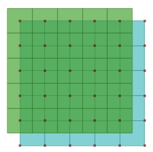
a grid offset equal to 0. Two products with the “pixel” label anchor (see Fig. 3.1) and 0 grid offset with different
grid spacing are not congruent. On the contrary, two products with an “area” anchor (see Fig. 3.2) and 0 grid offset
are, in fact, congruent. Therefore, we have applied a regridding process to make the former congruent.
In addition, the input NDVI products have a spacing of 1/112 degrees. Target spacings are defined by REQ 08 in
[PSDC_WP] and summarised in the Appendix - Input Products. A regridding process has been applied to adapt
the original grids to the target ones.
Note that, for future evolutions, it may be desirable to have data provided in multiple resolutions so that a com-
munal, less dense grid is used only to combine data that are defined on different grids.
3.2.3 Pixel-wise error measures and quality flags
For pixel-wise error measures and quality flags, resampling has been managed separately. In fact, some special
variables like data quality flags, relative errors, and statistical quantities cannot be resampled using standard inter-
polating functions. Instead, specific interpolating functions have been used, that take into account the way such
variables are calculated. For variables indicating pixel-based uncertainty measures, such methods are provided in
the uncertainties reference document as per requirement REQ 02 in [PSDC_WP].
3.2.4 Pixel center
On the grid, each data value must be associated with either the vertex, or the centre of the cell described by the
coordinates. In the metadata, this association is respectively flagged via coordinate attribute anchors “area” or
“pixel”.
When a value is associated to the centre of the cell, this cell can be thought as representing a point in the real
world. However, such grids with cells of different sizes are not congruent (see Fig. 3.1), as a cell does not include
a whole number of multiple sub-cells.
On the contrary, if each cell represents instead an area in the real world, cell-vertices make up all possible locations
to which the data value can be associated. Therefore, vertices as locations are a preferred choice, as grids of
different sizes are congruent when a vertex is used as tie-point (see Fig. 3.2).
Since PSDC data uses grids with different resolutions, choosing the “area” option makes such grids congruent
from one to the other. Fig. 3.1 and Fig. 3.2 further clarify the underlying reasons.
The CF conventions try to tackle this problem by adding auxiliary variables containing the vertex coordinates
of each cell. Those new variables are thus defining the cells. In this case, the bounds attribute is added to
the appropriate coordinate and filled with the name of the variable containing the cell vertex values for such
coordinate. For PSDC data no bounds attribute have been added, since a regridding process was applied to the
input products to make them congruent, generating new spatial grids following the pixel-is-area convention.
3.3 Temporal coordinate
This section analyses the issues that have been encountered when transforming data to comply with PSDC re-
quirements, specifically the temporal data representation.
8project-docs/methods-document
1.0.2, May 6, 2021
EUMETSAT Prototype Satellite Data Cube - Methods Document
Fig. 3.1: The case when using different grids with the anchor attribute: “pixel”.
Fig. 3.2: The case when using different grids with the attribute: “area”.
9project-docs/methods-document
1.0.2, May 6, 2021
EUMETSAT Prototype Satellite Data Cube - Methods Document
3.3.1 Reference time
Reference time is the time from when the coordinate starts. In fact, time is indicated as a certain amount of
units counted starting from the reference time. The reference time has been set equal for each variable, explicitly
indicated in the units attribute of the time coordinate.
This issue is strictly related with the one concerning time units.
3.3.2 Temporal resolution
As per requisite REQ 06 in [PSDC_WP], the indicated temporal resolution has been used. The intervals are month,
10-day, day and hour (10-day starting at 1st, 11th, and 21st of the month). The original data were already in the
requested temporal resolution, except for LST data which is provided with a temporal resolution of 15 minutes.
3.4 Aggregated variables
In the Data Cube, it must be possible to compare and combine variables. This section analyses some outstanding
issues in this respect.
3.4.1 Time aggregation
When dealing with time aggregated variables, such as a monthly mean, it is important to specify which point in
the time axis the values are associated with. For example, the single values of a monthly mean can be associated
either to the first or the last (or even, in selected cases, the fifteenth) day of each month.
Associating the value to the first day ensures uniformity among different months, while losing the concept that
such value is associated with the whole month. Instead, using the last day produces inhomogeneity. The last day
indeed differs from month to month, leading to other issues when performing statistical analyses.
3.5 Provenance
Any of the transformation processes discussed so far, has the potential to alter the data.
In order to keep track of changes and inform the final user about all processing operations the data has gone
through, data origin is saved and exposed as data attribute for each manipulation applied.
3.6 Common data model
As per requisite REQ 04 in [PSDC_WP], all data records included in the PSDC follow a common data model.
This common data model follows the CF-Conventions (version 1.8), implementing all requirements and as many
of the recommended guidelines as is practical. Supplementing the CF Conventions data also complies with the
Copernicus Climate Data Store (CDS).
10project-docs/methods-document
1.0.2, May 6, 2021
EUMETSAT Prototype Satellite Data Cube - Methods Document
CHAPTER
FOUR
METHODS
4.1 Overview
In this section we detail the methods and tools that have been used to overcome the problems exposed in chapter
Problem Analysis.
4.2 Spatial Resolution
The section describes the methods and tools that have been used to perform the spatial manipulations analysed in
Spatial Resolution.
4.2.1 Common geographic reference system
Per requisite REQ 07 in [PSDC_WP], the WGS-84 system with a longitude and latitude regular grid has been
used.
Therefore, all the original data projected in a geostationary system has been reprojected to a WGS-84 projection
(see Appendix - Input Products for details).
One of the main tools to perform reprojection operations on common reference systems is available in the Climate
Data Operator (CDO) suite. Another reliable and tested tool to compute such operations is GDAL. Although
GDAL is already used in other Data Tailor customisation plugins, we have adopted the CDO suite since it com-
prises a collection of standard operators used in the climate and meteorological scientific community.
As long as the PSDC variables are concerned, defining the longitude range between -180 and 180 degrees did not
cause any issue since the requested bounding box was entirely included in such range.
Information on the reference system has been stored in the crs variable. The following solutions are adopted:
• the CM-SAF, LSA_SAF, H-SAF, GPCC, and ERA5-Land products are confirmed by the providers to be
georeferenced to WGS84, so this information has been used in crs even if it is not declared in the input data
• according to the provider, the value of inverse_flattening attribute in the crs variable of LSA-SAF products
was wrong. The correct value of inverse_flattening has been reported in the output products instead.
11project-docs/methods-document
1.0.2, May 6, 2021
EUMETSAT Prototype Satellite Data Cube - Methods Document
4.2.2 Regridding
Per requirement REQ 08 in [PSDC_WP], the final resolution has been kept as close as possible to the original one
and specifically:
• all data that followed the convention pixel-is-point with a grid offset equal to 0 is regridded because two
products with “pixel” label anchor and 0 grid offset with different grid spacing are not congruent. On the
contrary, two products with “Area” anchor and grid offset 0 are congruent
• all NDVI data were in the correct projection, but using a spacing of 1/112 degrees. They have been regridded
using a spacing of 0.01 degrees.
Coordinates definitions are:
• 1 degree as grid spacing: longitude is defined in a range from -180 to 179 and latitude from -90 to 89
• 0.1 degrees as grid spacing: longitude is defined in a range from -180 to 179.9 and latitude from -90 to 89.9
• 0.05 degrees as grid spacing: longitude is defined in a range from -180 to 179.5 and latitude from -90 to
89.5
• 0.01 degrees as grid spacing: longitude is defined in a range from -180 to 179.99 and latitude from -90 to
89.99.
The CDO suite provides standard tested tools to perform both downsampling and oversampling operations with
different choices among available resampling functions. CDO remapbil operator has been used to regrid all data
following the convention pixel-is-point with a grid offset equal to 0. Whereas, in order to regrid the LSA SAF
NDVI input variables from the input regular grid with 1°/112 of grid spacing to the output regular grid with a
grid spacing of 0.01°, the scipy.ndimage.map_coordinates function has been used to perform a nearest neighbour
resampling.
4.2.3 Ancillary variables
For variables indicating pixel-based uncertainty measures, as per requisite REQ 02 in [PSDC_WP], methods
for correct interpolation are provided in the Evaluation of Measurement Data—Guide to the Expression of the
Uncertainty in Measurement.
The following approach has been adopted to regrid pixel-based uncertainty measures. The re-gridding implies that
the value of each “new” cell is in the middle of a square made of 4 input cells, as shown in Fig. 4.1, where the
output cells are colored in light-blue and the input cells are colored in green. So, a sliding window of size 2x2 has
been considered to estimate the value of each output cell, according to the following rules:
• if the ancillary variable represents an error estimate: we have used the same method adopted for the resam-
pling of the main variable to which the error refers, i.e. CDO remapbil
• if the ancillary variable is a quality flag: the resampling has been made according to the following rules:
1. if in the sliding window 4 values are identical, the output value is that value
2. if in the sliding window the values are discordant, the output value is either an already existent value,
or a new value that stands for “undefined”, “uncertain”.
With regard to rule 2 (i.e. discordant values in the sliding window), to resample the quality flag variables,
we have adopted the following values:
– LSA-SAF METREF quality flag: the new value, -5, stands for “undefined”
– LSA-SAF LST quality flag: the new value, 1, stands for “undefined”
– LSA-SAF LAI, FVC, FAPAR quality flags: the existent value, 0, is associated to the first bit. The
actual meaning is “ocean”, the new meaning is “ocean/undefined”.
• for LSA-SAF NDVI products: resampling also implies a change in spatial resolution from 1°/112 to 0.01°.
In this case, we have used, also for the ndvi main variable, the same interpolation method chosen for the
ancillary variables (day_in_decad, total_clear_observation and status_flag), i.e. the nearest neighbour in-
terpolation. In this way, missing values are consistent in all variables. Note that the resampling of the
12project-docs/methods-document
1.0.2, May 6, 2021
EUMETSAT Prototype Satellite Data Cube - Methods Document
Fig. 4.1: Grid with data associated with the centre of cells (green) versus grid with data associated with a vertex
of the cells (blue).
associated quality flag status_flag does not follow the rules described above because the nearest neigh-
bour interpolation is already enough. Knowing that CDO remapnn operator is very slow, we have used
scipy.ndimage.map_coordinates function.
4.2.4 Pixel center
To achieve congruency between different grids, coordinates have been re-labeled so that each couple of coordinate
values indicates the south-west corner of a cell. Moreover, the point indicated by the longitude/latitude couple (0,
0) corresponds to the lower left corner of the cell having as north-east corner:
• (1, 1) when grid spacing is 1 degree
• (0.1, 0.1) when grid spacing is 0.1 degrees
• (0.05, 0.05) when grid spacing is 0.05 degrees
• (0.01, 0.01) when grid spacing is 0.01 degrees.
13project-docs/methods-document
1.0.2, May 6, 2021
EUMETSAT Prototype Satellite Data Cube - Methods Document
4.3 Temporal coordinate
This section describes the methods and tools that have been used for the temporal coordinates manipulation anal-
ysed in Temporal coordinate.
4.3.1 Reference time
In UNIX systems, the de-facto standard for this value is 01/01/1970. This date is also the reference used in the
Copernicus Climate Data Store (CDS) common data model. Such reference time has been explicitly indicated in
the units attribute of the time coordinate i.e. “seconds since 1970-01-01”. The temporal reference system UTC
has been employed. The units is seconds from the reference time. An example is reported in Fig. 4.2
Fig. 4.2: Example of the time coordinate defined in the CDS common data model.
This issue is strictly related to the time units one, and they have been handled together using the tested library
xarray.
4.3.2 Temporal resolution
Time intervals are month, 10-day, day and hour (10-day starting at 1st, 11th and 21st of the month). The original
data were already in the requested temporal resolution, except for LST data, provided with a temporal resolution
of 15 minutes. For LST data only, full-hour values have been considered so that the final temporal resolution is
hourly.
4.4 Aggregated variables
In this section, the methods and tools that have been used to handle the data aggregation issues are reported.
14project-docs/methods-document
1.0.2, May 6, 2021
EUMETSAT Prototype Satellite Data Cube - Methods Document
4.4.1 Time aggregation
The start of the time intervals has been used as value for time coordinate (e.g. first day of the month for monthly
data). Since all data were already in the final time resolution and no aggregation was requested, when the reference
time was changed, xarray automatically managed time labeling accordingly.
4.5 Provenance
A ‘history’ attribute has been used to keep track of the data origin and all the applied processing operations. This
attribute records the related information in human-readable metadata, and is appended as a global attribute to the
data.
CF Convention recommendations on history attribute have been applied preserving the original provenance stored
in the attribute, and appending information on a new line.
In this case, the only call is to the EUMETSAT Data Tailor and such call is appended to the history metadata using
the following template:
: epct run-chain
4.6 Common data model
The PSDC common data model is structured to be compliant to the CF-Conventions (version 1.8) and to the
common data model of Copernicus Climate Data Store (CDS).
In particular, to enforce compliance with the CDS, when input files contain multiple variables having an obvi-
ous meaning even on their own, those are split into separated files. Therefore, each PSDC dataset contains one
geophysical variable (together with its associated ancillary variables), except for the input products having geo-
physical variables strictly related to each other. Those are kept in the same file, deviating from the CDS common
data model standard.
4.6.1 Variable names
For variable names, the standard names from the CF conventions are used. The most recent version of those are
found in document NetCDF Climate and Forecast (cf) Metadata Conventions, applying the official Guidelines for
Construction of CF Standard Names.
A detailed investigation of the input dataset revealed, in some cases, the need for new variable names. In these
cases, we have escalated the request to add the variable name to the CF conventions. A proposal for the variable
name has been added in the tentative_standard_name attribute of the output dataset, to make it visible to the users,
who may then provide feedback.
Long names are written with no capital letters.
Where short names do not exist, an attempt has been made to generate meaningful ones by analogy with existing
cases. An overview of the proposed tentative standard names is provided in Appendix - Tentative standard names.
15project-docs/methods-document
1.0.2, May 6, 2021
EUMETSAT Prototype Satellite Data Cube - Methods Document
4.6.2 Attribute names and values
For the platform, sensor, product_version and doi attributes:
• when the value in the input product was NA, default values from configuration files were used
• for CMSAF_CDR_* products, the product_version has been read from original metadata, and the
attribute doi from the id attribute; note that in some input products the id was in the form
DOI:10.5676/EUM_SAF_CM/SARAH/V002_01 which has been kept without modifications in the output
product
• for CMSAF_ICDR_* products, the value of the sensor attribute has been read from original attribute instru-
ment
• for all other products, platform, sensor and product_version has been read from the original metadata.
The Region of Interest (or bounding box) in the original metadata was expressed in different ways (i.e. different
attribute names and different value types). As there is no uniform prescription in the CF Conventions on how to
express them, the bounding box attributes have been removed from the output products, and the information has
been served as metadata of the whole web catalog (i.e. not in the dataset, but in the THREDDS definitions).
16project-docs/methods-document
1.0.2, May 6, 2021
EUMETSAT Prototype Satellite Data Cube - Methods Document
CHAPTER
FIVE
APPENDIX - INPUT PRODUCTS
The following table summarizes temporal and spatial details for each type of input products supported:
17Table 5.1: Input products details.
Variable Temporal Res- Stats Value Temporal Res- Projection Anchor Regridding method (main Spatial Format
olution olution in Cube variables)* Resolution
in Cube
SIS monthly mean monthly geographic pixel CDO remapbil operator 0.05° NetCDF-4
SIS monthly mean monthly geographic pixel CDO remapbil operator 0.05° NetCDF-1.4
SIS daily mean daily geographic pixel CDO remapbil operator 0.05° NetCDF-4
SIS daily mean daily geographic pixel CDO remapbil operator 0.05° NetCDF-4
DNI monthly mean monthly geographic pixel CDO remapbil operator 0.05° NetCDF-4
DNI monthly mean monthly geographic pixel CDO remapbil operator 0.05° NetCDF-4
DNI daily mean daily geographic pixel CDO remapbil operator 0.05° NetCDF-4
DNI daily mean daily geographic pixel CDO remapbil operator 0.05° NetCDF-4
SDU monthly sum monthly geographic pixel CDO remapbil operator 0.05° NetCDF-4
SDU monthly sum monthly geographic pixel CDO remapbil operator 0.05° NetCDF-4
SDU daily sum daily geographic pixel CDO remapbil operator 0.05° NetCDF-4
SDU daily sum daily geographic pixel CDO remapbil operator 0.05° NetCDF-4
LST 15 min. Instantaneous hourly geographic pixel CDO remapbil operator 0.05° NetCDF-4
18
LST 15 min. Instantaneous hourly geographic pixel CDO remapbil operator 0.05° NetCDF-4
METREF daily Instantaneous daily geographic pixel CDO remapbil operator 0.05° NetCDF-4
METREF daily Instantaneous daily geographic pixel CDO remapbil operator 0.05° NetCDF-4
NDVI 10-daily composite 10-daily geographic pixel nearest neighbour using 0.01° IMG +header
scipy.ndimage.map_coordinates - XML meta-
function data
NDVI 10-daily composite 10-daily geographic pixel nearest neighbour using 0.01° IMG +header
scipy.ndimage.map_coordinates - XML meta-
function data
FVC daily composite daily geographic pixel CDO remapbil operator 0.05° NetCDF-4
FVC daily composite daily geographic pixel CDO remapbil operator 0.05° NetCDF-4
LAI daily composite daily geographic pixel CDO remapbil operator 0.05° NetCDF-4
LAI daily composite daily geographic pixel CDO remapbil operator 0.05° NetCDF-4
fAPAR daily composite daily geographic pixel CDO remapbil operator 0.05° NetCDF-4
fAPAR daily composite daily geographic pixel CDO remapbil operator 0.05° NetCDF-4
Soil Wet- daily Valid 00UTC daily geographic pixel CDO remapbil operator 0.1° NetCDF-4
ness (GRIB2 also
available)
EUMETSAT Prototype Satellite Data Cube - Methods Document
1.0.2, May 6, 2021
project-docs/methods-document
continues on next pageTable 5.1 – continued from previous page
Variable Temporal Res- Stats Value Temporal Res- Projection Anchor Regridding method (main Spatial Format
olution olution in Cube variables)* Resolution
in Cube
Soil Wet- daily Valid 00UTC daily geographic pixel CDO remapbil operator 0.1° NetCDF-4
ness (GRIB1 also
available)
Precip monthly mean monthly geographic area not regridded 1° NetCDF-4
T2m monthly mean monthly geographic pixel CDO remapbil operator 0.1° GRIB
19
EUMETSAT Prototype Satellite Data Cube - Methods Document
1.0.2, May 6, 2021
project-docs/methods-documentproject-docs/methods-document
1.0.2, May 6, 2021
EUMETSAT Prototype Satellite Data Cube - Methods Document
* Note that the Regridding method used for Ancillary variables is detailed in Ancillary variables.
20project-docs/methods-document
1.0.2, May 6, 2021
EUMETSAT Prototype Satellite Data Cube - Methods Document
CHAPTER
SIX
APPENDIX - TENTATIVE STANDARD NAMES
The following table summarizes the tentative standard names for each product:
21Table 6.1: Proposed standard names.
Product-ID Original variable short-name Proposed standard-name for PSDC
CMSAF_CDR_DNI / CMSAF_ICDR_DNI DNIC/DNIc surface_normalized_direct_shortwave_flux_in_air_assuming_clear_sky
CMSAF_CDR_DNI / CMSAF_ICDR_DNI DNI surface_normalized_direct_shortwave_flux_in_air
GPCC_PRECIP s number_of_stations
GPCC_PRECIP interpolation_error interpolation_error
GPCC_PRECIP solid_p proportion_of_solid_precipitation
GPCC_PRECIP liquid_p proportion_of_liquid_precipitation
GPCC_PRECIP corr_fac correction_factor
GPCC_PRECIP abs_gauge_err absolute_gauge_error
GPCC_PRECIP rel_gauge_err relative_gauge_error
HSAF_CDR_WET/HSAF_ICDR_WET var40 soil_wetness_index_in_layer_1
HSAF_CDR_WET/HSAF_ICDR_WET var41 soil_wetness_index_in_layer_2
HSAF_CDR_WET/HSAF_ICDR_WET var42 soil_wetness_index_in_layer_3
HSAF_CDR_WET/HSAF_ICDR_WET var43 soil_wetness_index_in_layer_4
LSASAF_CDR_LST / LSASAF_NRT_LST LST land_surface_temperature
LSASAF_CDR_LST / LSASAF_NRT_LST standard_error land_surface_temperature standard_error
22
LSASAF_CDR_METREF / LSASAF_NRT_METREF METREF reference_evapotranspiration
LSASAF_CDR_NDVI / LSASAF_ICDR_NDVI DAY number_of_days_in_decad
LSASAF_CDR_NDVI / LSASAF_ICDR_NDVI TCO number_of_clear_observation
EUMETSAT Prototype Satellite Data Cube - Methods Document
1.0.2, May 6, 2021
project-docs/methods-documentproject-docs/methods-document
1.0.2, May 6, 2021
EUMETSAT Prototype Satellite Data Cube - Methods Document
CHAPTER
SEVEN
GLOSSARY
This section contains the main definitions and acronyms used throughout the document.
Acronyms not specific to Data Cube can be found at https://www.eumetsat.int/website/home/Satellites/Glossary/
Acronyms/index.html
7.1 Definitions
Customisation plugin A Python software package which contains one or more customisation back-
ends.
Customisation process The process executed by the EUMETSAT Data Tailor to apply the customi-
sation functions specified by the user to one or more input products. A customisation process
only generates one output.
ROI Extraction Data Tailor Customisation Function which allows to extract a Region of Interest
according to a predefined bounding box from the input product.
Validation The process that ensures that EUMETSAT (user) requirements are met, and the system
behaves as intended in an “operational” environment.
Verification The process that ensures that the system is correctly designed and implemented with
respect to the system requirements.
7.2 Acronyms
C3S Copernicus Climate Change Service
CARD4L CEOS Analysis Ready Data for Land
CDR Climate Data Records
CDS Climate Data Store
CEOS Committee of Earth Observation Satellites
DR4PSDC Data Records for Prototype Satellite Data Cube
FAT Factory Acceptance Tests
FCDR Fundamental Climate Data Records
FDR Fundamental Data Records
GPCC Global Precipitation Climatology Centre
HDF Hierarchical Data Format
ICDR Interim Climate Data Records
ICSI Information Centric Service Infrastructure
23project-docs/methods-document
1.0.2, May 6, 2021
EUMETSAT Prototype Satellite Data Cube - Methods Document
MET METeosat
NetCDF Network Common Data Form
OSAT On-Site Acceptance Test
PSDC Prototype Satellite Data Cube
ROI Region Of Interest
TBC To Be Confirmed
TBD To Be Defined
TRB Test Review Board
TRR Test Readiness Review
USC User Support and Climate Services Division of EUMETSAT
VCD Verification Control Document
VG Validation Goal
WMS Web Map Services and Visualization Systems
24You can also read