Europa Oil & Gas Atlantic Ireland, Kiely East and the next Brent Province - APPEX 2019
←
→
Page content transcription
If your browser does not render page correctly, please read the page content below
Europa Oil & Gas

                       Atlantic Ireland, Kiely East
                      and the next Brent Province
                                           Hugh Mackay,
                                        CEO Europa Oil & Gas

                                          APPEX 2019
Presentation available to download at www.europaoil.com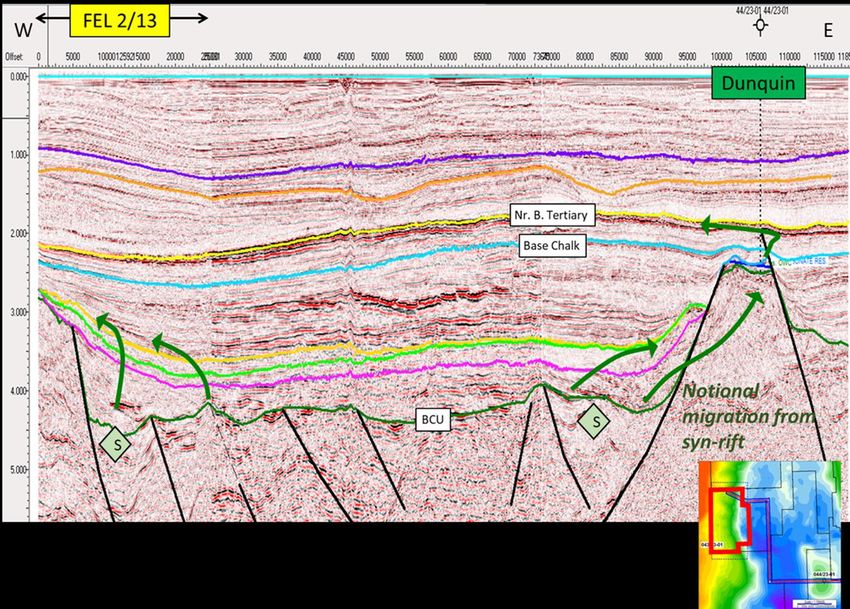
KIELY EAST PROSPECT – key facts
   • FEL 2/13, South Porcupine Basin, Atlantic Ireland
   • Europa 100% interest
   • 100% covered by 3D seismic data: 2013 proprietary 3D, 2018 proprietary
     reprocessed PSDM 3D data and TGS CREAN multiclient 3D data
   • Upper Jurassic marine source rocks - proven
   • Middle Jurassic marine sandstone reservoir – not proven yet
      • But might be by CNOOC’s 2019 Iolar well 70km to south in FEL 3/18
   • Large tilted fault block structure
   • Analogue Brent province
   • 280 million boe gross mean un-risked prospective resources on block
      • Could double with contribution from structure in open acreage
   • Seeking farm-in partner to drill an exploration well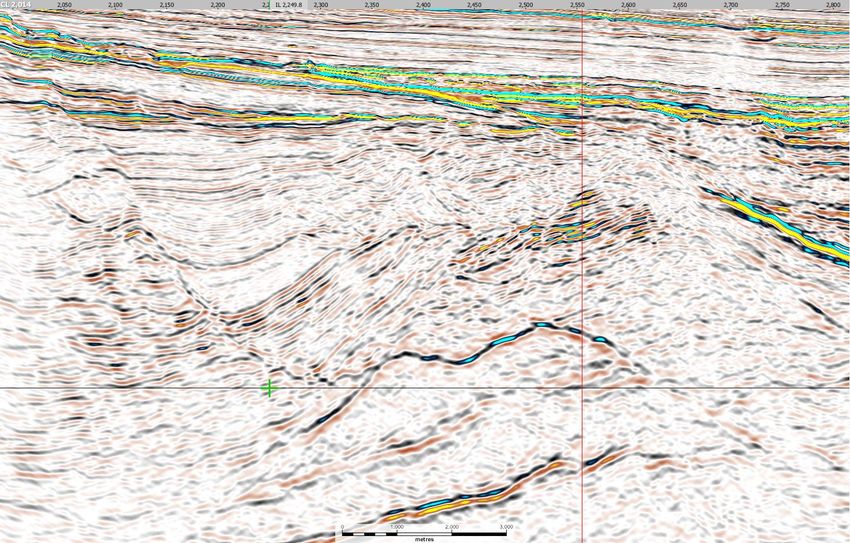
EUROPA IRELAND 2019                                                                      LO 16/20
                                                                                         Near-Corrib gas

•   Six licences or licensing options.

•   Play diversity – Cretaceous fans, Jurassic pre- and syn-   LO 16/22
                                                               Padraig Basin
    rift, Triassic gas.                                        Triassic gas + oil?

•   Four Europa-operated licences covered by new 3D
    PSDM seismic, leading to well-defined drill ready
    prospects.
                                                                                                           LO 16/19 (Cairn Op.)
                                                               FEL 2/13                                    CREAN 3D
•   Expect to survey drill sites for three leading prospects   Kiely pre-rift fault blocks
                                                               Kilroy slope apron fan
                                                                                                           interpretation in
                                                                                                           progress
    in 2019:
    ➢   LO 16/20 Inishkea Triassic gas
    ➢   FEL 1/17 Edgeworth fault block
    ➢   FEL 2/13 Kiely East fault block
                                                                                                                      FEL 1/7
•   Focus here is on FEL 2/13 on west flank of South                                                                  Multiple pre-rift
                                                                                                                      fault blocks
    Porcupine basin and our farmout to drill the Kiely East                                                           Egerton syn-rift
    prospect                                                            FEL 3/13
                                                                        Wilde, Beckett &
                                                                        Shaw Lower
                                                                        Cretaceous fans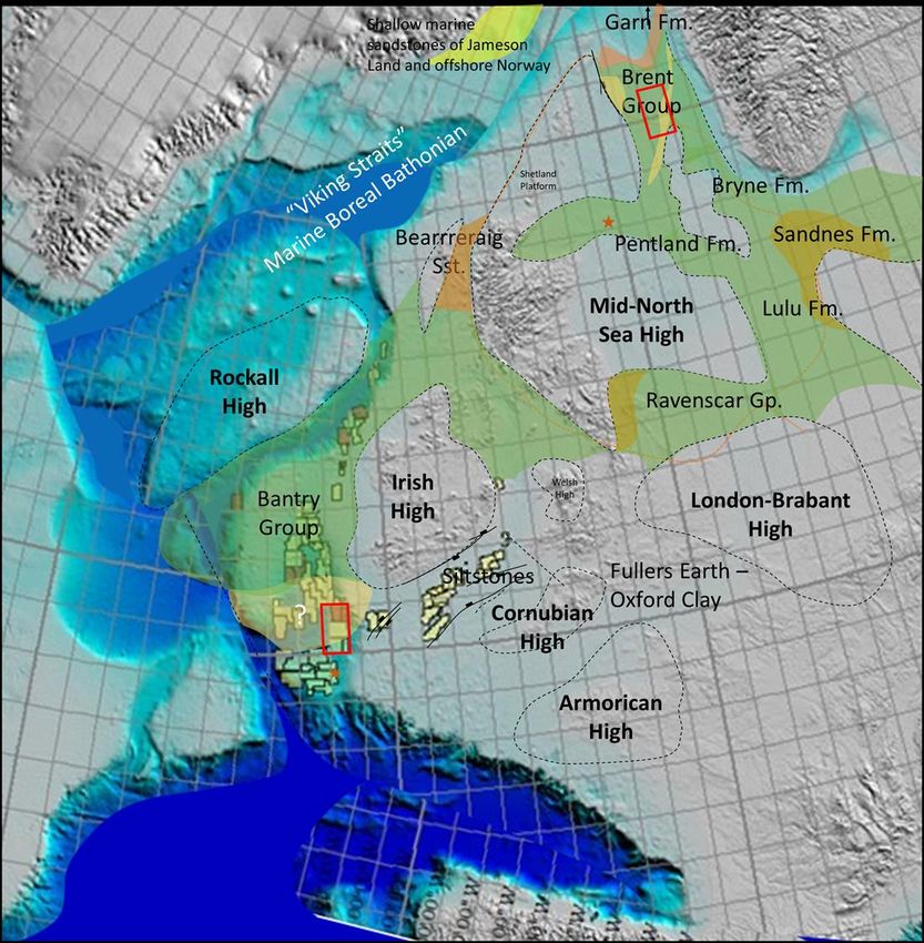
WHY SHOULD I BE INTERESTED?
                                            Meet the neighbours

                              Active companies in Atlantic Ireland
                                                                        4
                              Europa #1 in 2015 licence round, =1 with CNOOC International for operated licences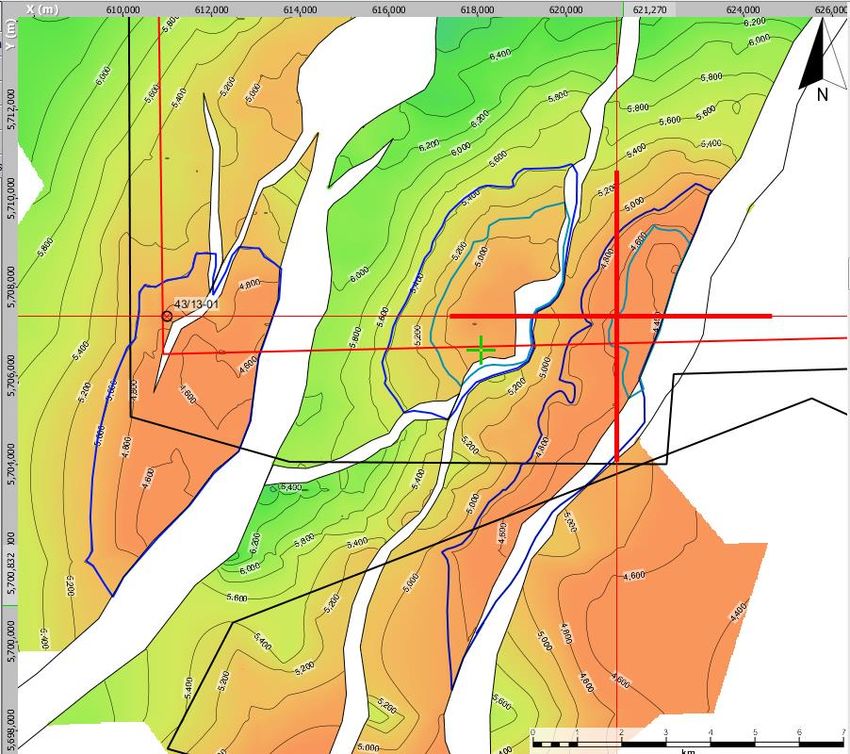
PORCUPINE DRILLING HISTORY

                     6                                              40000

                     5            Porcupine Basin Wells & Seismic

                                                                            Cumulative 3D Seismic (km2)
                                                                    30000
                     4                                                                                                   North
    Wells per Year

                                                                                                                       Porcupine
                     3                                              20000
                                                                                                                         Basin
                     2
                                                                    10000                                 43/13-1
                     1                                                                                                      44/23-1

                     0                                              0
                         1977   1984   1991   1998   2005   2012

                                                                                                              53/6-1
                1. South Porcupine basin is under explored with                                                       South
                   three wells in forty years                                                                       Porcupine          Gollum
                2. ~30,000 km2 3d acquired in last six years                                                          Basin           Channels
                3. New phase of drilling about to start – enabled
                   with new technology and new ideas                                                                               62/7-1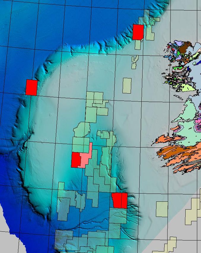
Mid-Jurassic Regional Facies - 1

Shoreface sandstones provide improved porosity
and better connectivity. They are the critical
difference between highly productive reservoirs
                                                             100km
(such as the Brent Group of the North Sea) and the
more difficult, largely non-marine, reservoirs of the
Northern Porcupine (such as Connemara).
                                                            Porcupine
But note the limited spatial extent of the shoreface.       basin at same
The Brent Province occupies little more than a Quad.        scale

                        North Sea Bajocian paleogeography
                                 (Rattey & Hayward, 1993)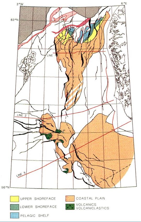
Middle Jurassic Regional Facies - 2

The Middle Jurassic of the European
Area is dominated by paralic
sediments, but shallow marine
sediments (Brent Gp., Bearreraig
sandstone, Sandnes Fm., Ravenscar
Gp.) are developed in many places
around the periphery.

FEL 2/13 is nearly 100km from the
nearest Jurassic well control. There is
a high likelihood that shallow marine
sediments exist somewhere in the
South Porcupine as the Jurassic           100km
seaway opens towards the
propagating Atlantic Ocean.

The presence of shallow marine mid-
Jurassic on FEL 3/13 could be the key
transformative factor for Porcupine
reservoir commerciality.

LOCATION

                                                                     Lead A

                                                                 5km                                            FEL 2/13

             43/13-1                                                                              W-E
                                                                                                 Seismic
                              Dunquin North

             Iolar

                       Druid/Drombeg                                     Kiely West

                                                                      43/13-1

    •   1988, 43/13-1, oil shows and source
    •   2013, Dunquin North, Cretaceous carbonates, 44                                                     Kiely East
        m residual oil column                             43/13-1
                                                         Structure                               N-S
    •   2017, Druid/Paleocene Drombeg/Cretaceous fan                                           Seismic
    •   2019, Iolar drill this summer
                                                             Europa Top Pre-Rift (C.I. 200m)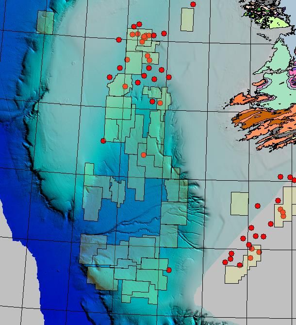
Kiely Prospects - Key Features

• Large west-tilted fault blocks with Middle Jurassic to Oxfordian reservoir sequence.
  Extends south into open acreage.

• BP 43/13-1 tried the play with a very ambitious well for the date (1988). Latest
  biostratigraphy (Merlin/PIP) shows that they did not penetrate the pre-Kimmeridgian
  sequence.

• 43/13-1 did prove Tithonian/Kimmeridgian source rocks and had shows in thin latest
  Kimmeridgian sand stringers which proved that this source was oil-mature down dip.

• The seismic character of the pre-rift over Kiely and the overlying highly erosive rift-
  onset unconformity encourages the possibility of older (and potentially shallow
  marine) Middle Jurassic reservoirs – upside reservoir quality compared with further
  north. The nearest Jurassic well control is over 100km to the north.
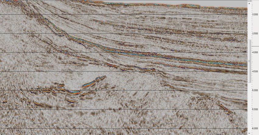
Kiely W-E Seismic Xline 2014 PSDM full offset stack (depth domain)
43/13-1                                   In line 2555

                         Kiely West      Kiely East

   s
   s

       Kimmeridgian
   s

       TD

    Liassic?
Kiely W-E Seismic Xline 2014 PSDM full offset stack (depth domain)
43/13-1 Model A In line 2555
Kiely West Kiely East
BCU
Gas Gas
s Late Tithonian Paleocene
Kimmeridgian s Early Tithonian
Base Tertiary
Kimmeridgian
s
Kimmeridgian
Aptian Unc.
TD
Liassic?
Liassic?
Liassic?
Uilleann Halite?Kiely W-E Seismic Xline 2014 PSDM full offset stack (depth domain)
43/13-1 In line 2555
Kiely West Kiely East
s
s
Kimmeridgian
s
TD
Liassic?Kiely W-E Seismic Xline 2014 PSDM full offset stack (depth domain)
43/13-1 Model B In line 2555
Kiely West Kiely East
BCU
Gas Gas
s Late Tithonian Paleocene
Kimmeridgian s Early Tithonian
Base Tertiary
Kimmeridgian
s
Kimmeridgian
Aptian Unc.
TD
Oxfordian
Liassic?
Note the different dips and
amplitudes within each unit.
Liassic?
Uilleann Halite?Source Rock Marine Tithonian source rock is proven in 43/13-1. The source rock (immature at the well) matches shows in the latest Kimmeridgian. The Kimmeridgian oil is interpreted to have been expelled at a low maturity level, suggesting that down-dip source quality is high. On a broader scale, Kimmeridgian and Tithonian restricted marine source rocks appear to be widespread and responsible for oils in Connemara, Spanish Point and Burren. The source of the Dunquin oil is unknown to us, but we would expect it to be Upper Jurassic also (Dunquin shares a kitchen with FEL 2/13 – next slide). 34/15-1 (and related oil in 35/6-1) show that source rocks within the Middle Jurassic sequence are capable of contributing a waxy, terrigenous oil. We interpret a significant Lower Jurassic section in the licence, so this could contribute in FEL 2/13 as it does in 62/7-1, through the Celtic Sea and into southern England. Gas-prone Carboniferous may also be present at depth beneath the licence.
The kitchen is potentially shared with Dunquin
Depth mapping Kimmeridgian / Oxfordian / Middle Jurassic
                               FEL 2/13

                                                    Kiely West
                                                                           P50 closure

                                          P50 closure                           P90 closure

                                      P90 closure

                                                                                  XL 2014

                                                                                            •   Kiely East well location
                                                                                            •   Site survey planned for
          Extent of 2013 3D survey                               IL 2555
                                                                                                summer 2019
                                                                                            •   Drillable from 2020
                                                                                                onwards

Extent of 2004 ENI 3D survey
Kiely MCS
Ireland FEL 2/13 Kiely East Prospect (on block)
Units Distribution Lo Trunc Hi Trunc P90 P50 P10 Mean
Gross Rock Volume 6 3 Lognorma l 0.00 15000.00 2625.00 4849.00 8957.26 5323.30
x10 m
NTG fra c Lognorma l 0.00 0.95 0.10 0.26 0.70 0.30 Kiely East 280 mmboe gross
Porosity fra c Norma l 0.08 0.25 0.11 0.17 0.22 0.17
HC Saturation fra c Norma l 0.40 0.90 0.55 0.65 0.75 0.65 mean un-risked prospective
Bo STB/bbl Norma l 1.10 1.70 1.30 1.45 1.60 1.45
Stock Tank Oil in Place (mmbbl) x10 bbl6 167.94 542.64 1603.58 756.96 resources (on block)
Recovery Factor fra c Norma l 0.10 0.70 0.15 0.30 0.45 0.31
Prospective Oil Resources (mmbbl) 6 44.68 158.28 516.02 236.00
x10 bbl
GOR s cf/STB Lognorma l 100.00 4000.00 400.00 900.00 2025.00 1098.94
Prospective Gas Resouce s cf 31.46 144.49 592.89 261.85
37% on block at P50 ->
Total Prospective Resources (mmboe) x106 boe 52.10 187.27 612.07 279.64 P50total 506mmboe
Ireland FEL 2/13 Kiely West Prospect (on block)
Units Distribution Lo Trunc Hi Trunc P90 P50 P10 Mean
Gross Rock Volume
NTG
x10 m
fra c
6 3 Lognorma l
Lognorma l
0.00 15000.00
0.00 0.95
1013.00
0.10
4027.00 16008.62
0.26 0.70
4508.54
0.30
Kiely West 225 mmboe gross
Porosity
HC Saturation
fra c
fra c
Norma l
Norma l
0.08
0.40
0.25
0.90
0.10
0.55
0.16
0.65
0.21
0.75
0.16
0.65
mean un-risked prospective
Bo
Stock Tank Oil in Place (mmbbl)
STB/bbl Norma l
x10 bbl6
1.10 1.70 1.30
70.01
1.45
360.92
1.60
1480.34
1.45
614.02
resources (on block)
Recovery Factor fra c Norma l 0.10 0.70 0.15 0.30 0.45 0.31
Prospective Oil Resources (mmbbl) 6 19.17 103.99 452.94 190.49
x10 bbl
GOR s cf/STB Lognorma l 100.00 4000.00 400.00 900.00 2025.00 1099.07
Prospective Gas Resouce s cf 14.65 93.43 492.15 207.88
83% on block at P50 ->
Total Prospective Resources (mmboe) x10 boe
6
22.48 123.16 533.86 225.13 P50total 148mmboeCNOOC International Iolar well, summer 2019, important pre-rift test
WNW 10kms ESE
Seabed
Base
Tertiary
Base Cretaceous
Iolar structure with similar Middle Iolar is 70km south of Kiely East and 125 km west of Edgeworth
Jurassic (Edgeworth & Kiely East) Iolar success will de-risk 1 billion boe in five Europa pre-rift
seismic expression and structural style prospects
PSTM Seismic line PAD13-047 reproduced with permission of DCCAEKIELY EAST PROSPECT – key facts
• FEL 2/13, South Porcupine Basin, Atlantic Ireland
• Europa 100% interest
• 100% covered by 3D seismic data: 2013 proprietary 3D, 2018 proprietary
reprocessed PSDM 3D data and TGS CREAN multiclient 3D data
• Upper Jurassic marine source rocks - proven
• Middle Jurassic marine sandstone reservoir – not proven yet
• But might be by CNOOC’s 2019 Iolar well 70km to south in FEL 3/18
• Large tilted fault block structure
• Analogue Brent province
• 280 million boe gross mean un-risked prospective resources on block
• Could double with contribution from structure in open acreage
• Seeking farm-in partner to drill an exploration wellTHANK YOU
FOR MORE INFORMATION
PLEASE VISIT US AT BOOTH 9
mail@europaoil.com
+44 20 7224 3770
www.europaoil.comYou can also read