FROM SEA TO MOUNTAINS - Visit Waterford
←
→
Page content transcription
If your browser does not render page correctly, please read the page content below
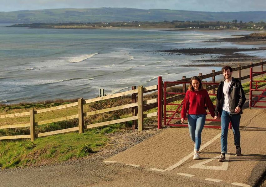
FROM SEA TO MOUNTAINS
WALK WATERFORD - FROM SEA TO MOUNTAINS
   Walk Waterford is a series of recreational walks throughout Waterford.
   Choose a trail that suits you: from stunning coastal walks to breathtaking
   mountain scenery to tranquil woodland settings to picturesque towns
   and villages and Ireland’s oldest city.

   Find your trail in Waterford…where Ireland begins.
Page
COASTAL TRAILS 3
Ardmore Cliff Walk 4 1
The Cunnigar 4 2
Dunmore East Walks 5
Dunmore East Coastal Walks 3
Dunmore East > Portally Cove
TABLE OF
Dunmore East > Ballymacaw Cove
Dummore East Woods Walk 4
CONTENTS
Tramore Walks
Tramore Nature Park
Dunes Walk, Tramore
6
5
6
Doneraile Walk 7
Waterford Estuary Walks 7
TRAIL NUMBER Cheekpoint Maritime Walk 8
REFER TO WATERFORD TRAILS MAP p.23 St. Ita’s Walk, Faithlegg 9
Passage East to Hurt Hill Walk 10
LONG DISTANCE TRAILS AND GREENWAY 8
East Munster Way 9 11
St. Declan’s Way 10 12
Waterford Greenway 11 13
MOUNTAIN TRAILS 12
Nire Valley Walks 13
Sgilloges Walk 14
Gap Walk 15
Coumlara Loop Walk 16
Coumduala Loop Walk 17
WATERFORD TRAILS MAP 14
Rathgormack Walks 15
Glenpatrick Bridge Loop 18
Lough Mohra Loop Walk 19
HOW TO USE THIS BROCHURE Rathbeag Loop Walk 20
Boolas Loop Walk 21
This Walk Waterford Brochure is a guide to almost 40 walks all across Waterford. Each walk has a map, trail description River Mahon Walks 16
and important trail information. Examples of the map and trail information symbols used are shown below. The trail Crough Wood Walk 22
maps give details of the trailhead location, nearest town/village and trail route. While every effort has been made to Mahon Falls Walk 23
ensure the accuracy of information contained within this brochure no liability can be accepted for any errors or NATURE AND WOODLAND TRAILS 17
omissions. The brochure will make it possible to choose the trail that is right for you. Happy walking! Colligan Wood Walks 18
Inchidrisla Loop Walk 24
Greenane Loop Walk 25
Ramp Boreen Walk, Tallow 19 26
MAP INFORMATION TRAIL INFORMATION Fenor Bog Walk 19 27
NODA LÉARSCÁILE - MAP INFORMATION Glenshelane Woods Walks 20
M2 GRADE Blue 28
Mótarbhealach
Motorway i Pointe Eolais
Information Point Multi-access, Easy, Moderate, Green 29
N25 Débhealach
Dual Carriageway
Bia ar fáil
Food available
700 Strenuous, Very Difficult Red 30
N25 Príomhbhóthar Náisiúnta
National Primary Road P Páirceáil
Parking
600
WAY MARKING
Melleray Walk 31
R259 Bóthar Réigiúnach
€ Meaisín Bainc 500 DISTANCE Lismore Walks 21
Regional Road Pass Machine
Mionbhóthar
Other Road
Leithris 400 Lady Louisa’s Walk 32
Bóthar Portaigh/Foraois
Toilets
Páirceáil Rothar 300 TYPE PARKING Round Hill Loop Walk 33
Bog/Forest Road Bicycle Parking Loop, Linear & TRAILHEAD The Towers Walk, Ballysaggartmore 34
200
Cosán Neamhshainithe Ionad Amhairc Molta
Undefined path
Líne Iarnróid
Recommended view point
100
TRAILHEAD OSI GRID REF Villierstown and Dromana Woods Walks 22
Railway Line Ball Suntais
Point of Interest 0 Méadar
ESTIMATED TIME GPS The Sailors Rock Walk 35
i Tús na Siúlóide
Trailhead
Metres
Dromana Wells Walk 36
NEAREST TOWN Anne Valley Walk 23 37
ASCENT OR VILLAGE
Coillearnach
Woodland 679
Spotairde (Méadar)
Spot height (Metres) URBAN TRAILS 24
Foraois Cladach Carraigeach
TERRAIN MINIMUM GEAR Waterford City 25
Forestry Rocky shore St. John’s River Walk 38
DOGS PERMITTED
Waterford Nature Park Walks 39
Aillte/Talamh Crochta WEBSITE General Information 26
Cliffs/Steep Ground
On a lead / No
Acknowledgements 27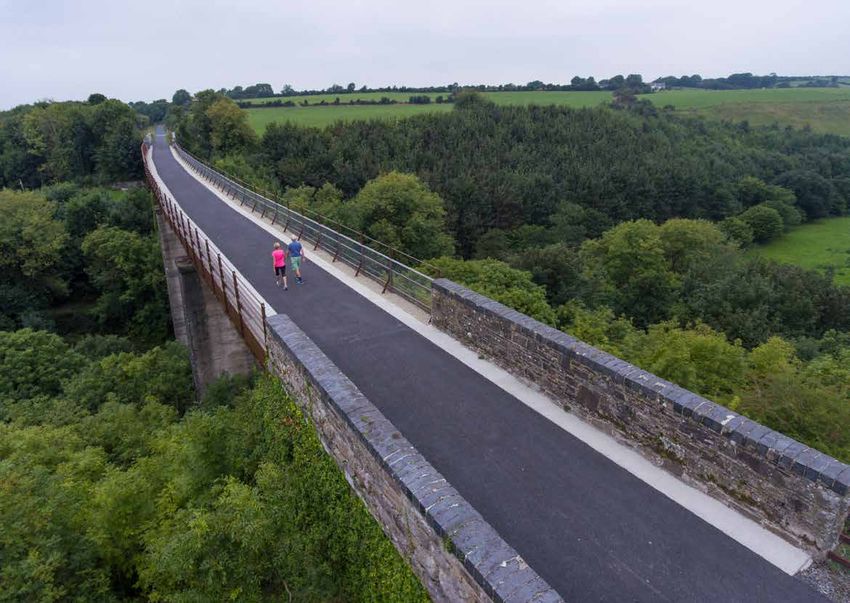
COASTAL TRAILS
ARDMORE CLIFF WALK 1 AN COINIGÉAR / THE CUNNIGAR 2 p4
DESCRIPTION:
N
Dún Garbhán
Suite i nGaeltacht na nDéise, siúlóid
P Dún na Mainistreach
Dungarvan
Eoc
N
R673
Youghaill álainne cois cósta atá sa Choinigéar, Abbeyside
hal
R67
i 0 0.25 0.5 km nó ‘An Cois’, mar a tugtaí air go háitiúil. i
3
P Cuan Airde Móire
Is féidir siúl amach ar an gCois trasna
Dún Garbhán
0 metres 400 800
Aird Mhór chuan Dhún Garbhán i dtreo Dhún na St. Augustine’s Church
Fearann Ardmore Ardmore Bay Dungarvan
Mainistreach le Cruachán agus Na Co-
Ghearóid
i P maraigh mar chúlbhrat os do chom- € i P Pointe na Coise
Cunnigar Point
Farrangarret St. Declan’s Well hair. Is tearmann é chomh maith d’éan-
Ceann Airde Móire bhreathnóirí agus lucht dúlra. Rinn na Saileog
Ardmore Ardmore Head Ringnasilloge
Cathedral
If you are looking for a refreshing and
Round Tower
Ardmore scenic coastal walk then the Cunnigar
Coastguard
Station is for you. This iconic feature is clear-
ly visible in Dungarvan Bay when ap-
proaching the town on the N25 from
Ard Ó Séasta
Cork. The sand spit is a feature of An Coinigéar (An Chois)
Ardocheasty
e
coastal deposition that extends from Cunnigar
oic
hr
the Gaeltacht peninsula across Dun-
key
B
An
ic
An Díseart garvan Bay. It is one of Waterford’s best
Br
Watchtower sites for rare waders such as Ringed
er
Dysert Wreck of the
Riv
Fr. O’Donnell’s ‘Samson’ Plover and American Golden Plover.
Well Banc an Tí Ghil
While walking admire the views, par- Whitehouse Bank
Ceann an Ráma
ticularly those across the Bay towards
Ram Head
Ballinacourty Lighthouse, Abbeyside
Church and King John’s Castle.
Whale and Dolphin
watching location
HOW TO GET THERE:
Leave Dungarvan heading west on the Siúlóid an Choinigéir
82, X 193 776; N25 towards Cork. Turn left on the R674 The Cunnigar Walk
Easy
51.951147, -7.721657 signposted for An Rinn (Ring). Follow the
signs to ‘An Coinigéar’. Baile na Cúirte Thuaidh i
4km Ardmore
Trekking shoes, rain gear, DID YOU KNOW:
Loop Gort na Daibhche Íochtarach
water, mobile phone The Cunnigar comes from the Irish word
1.5hrs On a lead
An Coinigéar, meaning rabbit warren.
An
P
Ri
nn
Cliff top path, laneways, At the Cunnigar’s northern extent you
minor roads www.visitwaterford.com are a mere 250 metres from Abbeyside
and approximately 400 metres from
Sea front, car park ‘The Lookout’, Dungarvan.
SPECIAL NOTES:
This is a cliff top walk. Under 12’s should be accompanied by a responsible adult. Check the weather forecast before embarking on your walk. Moderate Southern end of Cunnigar
Avoid the cliff walk on windy/foggy days.
6.5km 82, X 274 896
52.05852, -7.60025
DESCRIPTION: HOW TO GET THERE: DID YOU KNOW:
Wrapped around a long sandy beach From Dungarvan follow the N25 in the di- St. Declan’s Ecclesiastical Site, is one Linear An Rinn
the picturesque village of Ardmore rection of Cork. After approx. 18km make of the earliest ecclesiastical sites in Walking shoes,
2hrs
is steeped in history, being one of a sharp left onto the R673 (signs for Aird Ireland, dating from the 5th century. wind/rain jacket,
the oldest Christian settlements in Mhór/Ardmore). Once in Ardmore park Within the site is an impressive 29m water, mobile phone
Ireland. On your walk watch out at the beach car park and take the middle high 12th century round-tower, an Beach & Dunes
www.visitwaterford.com
for wonderful archaeology, coastal road past the Cliff House Hotel to where early stone oratory, and a ruined 12th
On a lead
birdlife and the ‘Samson’ shipwreck. it becomes a path leading to the old ruins. century cathedral.
DUNMORE EAST WALKS 3,4
Bá Dhún Mór
Dunmore Bay
p5
Dunmore East
Lighthouse
Coastal Walk
Gleann Díomais
2.0 km
Black
Knob
i
Nymphhall
An Bhinn Rua
P
Flat Rocks
Castle
P
Red Head
1.5
P
Dunmore East Woods Walk
i
Coilleach Thoir
Crossroads
Coxtown
Coxtown East
1.0
84
R6
DUNMORE EAST
P i
DÚN MÓR
Coilleach Thiar
Coxtown West
Ceann Phort Ailigh
0.5
DESCRIPTION: DID YOU KNOW:
Dunmore East Coastal Walk: Dunmore East is one of Dunmore East Coastal walk is situated above many
€
Portally Head
Waterford’s most picturesque fishing villages and a haven beautiful coves and inlets carved out of conglomerate
for visitors. Whether you are looking for a beach break, red sandstones known locally as pudding stone and
Earthwork
to take part in some adrenalin pumping water based used to build the harbour in the 1820’s.
e
activities or simply to sample some culinary seafood irg
Lá
rt ord
0
Gráig an Roide
Po terf
delights, then Dunmore East is the place to be. The Dun- Keep an eye out for the kittiwake colony in the harbour a
Port Ailigh
W
Graigariddy
more East Coastal Walk was extended in 2020 and now along with fulmar, red legged chough, cormorant and
Portally
Cnocán Pháidín
stretches from the trailhead at the harbour car park as shag. Watch out for the occasional seal popping its head
Knockanpaddin
far as Ballymacaw Cove, almost 7kms further along the up close inshore.
Waterford coast. The first section which takes walkers
as far as Portally Cove is ideal for those with a moderate DUNMORE EAST DUNMORE EAST
level of fitness; it includes steps and some undulations. TO BALLYMACAW COVE TO PORTALLY COVE SPECIAL NOTE
This linear walk is about a 4km round trip. For those
looking for a more challenging walk which requires a Strenuous | Moderate There is NO PARKING
good level of fitness then the section beyond Portally available at Portally Cove
Ceann Muice
Cove to Rathmoylan Cove and onto Ballymacaw Cove is 15km return | 4km return or Rathmoylan Cove.
Swines Head
Ráth Mhaoláin
an almost 15km round trip. There is only very
Rathmoylan
Linear | Linear limited parking space
Cill Mochuóg
Kilmaquague
Dunmore East Woods Walk; There are numerous ac- available at Ballymacaw
Rathmoylan
cessible pathways to enjoy in this beautifully maintained 4 to 5hrs | 1.5hr to 2hrs Cove. Please respect
local residents and park
Promontory Fort
woodland. In 1924, John Charles De La Poer, 7th Marquis responsibly.
Br.
Cliff top and grassy paths,
of Waterford, granted Dunmore East Woods and the park footbridges, steps, stiles,
in a trust, for the recreational use of the people of Dun- stream crossings Under 12’s must be
more East, and so it remains today. Dunmore East Woods accompanied by an
Dunmore East Harbour Car Pk adult. Do not walk along
Community
is particularly popular with families and those looking for this coastal walk on
Carbally
Standing
Centre
76, X 689 996
Stones
a relaxing stroll in wonderful sylvan surroundings.
Portally to Ballymacaw
windy or foggy days.
52.14519, -6.99309
An Corrbhaile Beag
HOW TO GET THERE: Dunmore East
Follow the signs for Dunmore East and Passage East
Cove Trail
Hiking boots/ walking shoes,
An Ghráig
Ballymacaw
through Waterford City onto the Dunmore Rd/R683.
Baile Mhac
wind/rain gear, water, snacks, Corbally Beg
Graigue
Keep right at the fork in the road at the petrol station mobile phone
Dháith
onto the R684. On entering Dunmore East follow the
main road (R684/Dock Road) past the left for The Strand On a lead
i
and after a further 1.25kms take a left towards the harbour r
www.visitwaterford.com hóe
N
followed by an immediate right towards the trailhead á M or
Tr ram
T
where there is ample car parking.
TRAMORE WALKS 5,6, 7 p6
N
2 km
s
Back Strand
une
An Chúltrá
1.5
dd
San
Tramore Nature
Park Walk
i
Tramore Nature Park
s
dune
Páirc na Fuiseoige
1
Sand
Cuan Thrá Mhór
P
0.5
DESCRIPTION: HOW TO GET THERE:
Doneraile Walk
Tramore is a beautiful coastal town only 13km south of Tramore is well served with ample car parking for the
Tramore Bay
P
Dunes Walk
Waterford City, where land and sea meet to create an walks highlighted here. Please see map for locations.
impressive 5km sandy beach ideal for walking, swim-
ming, surfing, kite surfing or simply enjoying a coffee DID YOU KNOW:
with a sea view. Tramore has a complete range of facil- Coastal views towards Brownstown Head and Great
0
ities for the holiday maker, from top class accommoda- Newtown Head are noteworthy for the pillars which
tion and a great selection of cafés and restaurants, to were constructed in the early part of the 19th century,
i
P
leisure activities such as surfing, fishing, horse riding, following the Seahorse disaster, as a navigational aid
Lady Doneraile’s Cove
golf and an Amusement Park for all ages. Famous for its for mariners. The Metalman stands on top of one of the
PROMENADE
P
ord
5km of golden, sandy beach surrounded by the Atlantic pillars at Great Newtown Head with his right arm out- terf rge
Wa rt Lái
Po
Ocean, the panorama of Tramore Bay is truly magnifi- stretched warning ships to keep away from the danger-
Cuan na Faille
Splashworld
Amusement Park
cent. It blends natural beauty with a lovely traditional ous rocks. Legend has it that he chants aloud a rhyme on
seaside town feel. stormy nights: “Keep off, good ship, Keep off from me,
Lady Elizabeth’s Cove
Gleann an Chuain
for I’m the rock of misery”.
There are numerous walks in the area, three of which
are recommended here: TRAMORE NATURE DUNES WALK DONERAILE WALK
PARK WALK
Dunes Walk: Tramore Dunes are located to the east of
TRÁ MHÓR
Tramore Coastguard
the town of Tramore. To access the Dunes you walk either Tramore Nature Park Car
TRAMORE
Gleann na mBád
Easy | Moderate | Easy
P i
Parking Area
Cultural Centre
Newtown Cove
along the sandy beach, along the sea wall or over the Public car park opposite
saltmarsh behind the sea wall. An invigorating trip around 1km | 5.5km | 5km Majestic Hotel
Metal Man Tower
the dunes is one of the best coastal walks in Waterford. Church Road (option
An Fear Miotail
Loop | Loop | Loop to begin from The Prom)
€
Doneraile Walk: This Walk provides panoramic views of 76, 92 015,
Tramore Bay, Backstrand and the surrounding coastline. 20mins | 1.5hrs | 1.5hrs 52.16394, -7.13378
S 584 015
P
It takes you right past Tramore Coastguard Cultural Cen- Gravel Path 76, 52.16317, -7.14736 75
R6
tre before leaving town and heading onto the Cliff Road Gravel path, shingle path 76, S 578 009
Metal Man Tower
in the direction of Newtown Cove and the Guillamene. and sand 52.15827, -7.15497
Tarmac, footpaths, road
Walking shoes,
Tramore Nature Park: Tramore Nature Park is the site Green arrows wind/rain jacket
of a former landfill which closed in 2005. It is now a 12
Coast
Green arrows
hectare public park with grassland, scrub and saltmarsh, Slí na Sláinte arrows On a lead
Copper
providing habitats for a range of bird and plant species.
R675
Tramore www.visitwaterford.com
WATERFORD ESTUARY WALKS 8,9,10 p7
i
Cheekpoint
Maritime N
DESCRIPTION: HOW TO GET THERE: Walk
Waterford Estuary Walks is a network of walks based From Waterford City follow the Dunmore Road/R683
around the communities of Passage East, Faithlegg and to Passage Cross. Turn left here for a further 1km. At a P Pointe na Síge
Cheekpoint in east county Waterford, just a 20 minute fork in the road continue straight ahead on the R683 for Cheekpoint
drive from Waterford City Centre. Take your time to im- a further 5kms before reaching the village of Passage
merse yourself in this scenic part of County Waterford, East. Alternatively take the right fork and follow the road An Mionnán
right here in Ireland’s Ancient East. Delight in the rich
history and heritage of the area, where nature abounds.
past Jack Meades Pub for a further 3kms until you reach
Faithlegg Church and parking on your left hand side. St Ita’s Walk
P Minaun Hill
DID YOU KNOW: CHEEKPOINT ST. ITA’S WALK, PASSAGE EAST-HURT HILL
i
Faithlegg was one of the first parishes to be established MARITIME WALK FAITHLEGG WALK
Catherine’s Bay
after the Norman conquest of Ireland 1169-1171. Faithlegg
House
Fáithling
An tSiúi
Moderate | Easy | Moderate Hotel
4.5km | 2.5km | 9km
Faithlegg
Cheekpoint marks the meeting place of the Three Sisters
river network; the Suir, Nore and Barrow which flow to
P Niúig
Nook
Loop | Loop | Loop 121m | 25m | 150m Wo Church
the sea creating Waterford Harbour. It is also the meet- o dla Cúil Boinne
nd Coolbunnia
ing place of the provinces of Munster and Leinster and 1hr 15 mins. | 40mins. | 2hrs 30mins. Pil
l
r
the counties of Waterford, Kilkenny and Wexford. Motte
Local roads, footpaths, steps, country lanes, and green
laneways (please be aware of traffic)
Ri
The Barrow Bridge, visible from Cheekpoint was once Hurt Hill
r
ve
Irelands’ longest bridge at 650 metres in length and consists
of 13 fixed spans mounted on twin 2.5 metre diameter
Blue arrows | Red arrows | Green arrows
Baile Uí Su
cast iron cylinders filled with concrete. Opposite Faithlegg Church | Opposite Faithlegg Church Cheannabháin ir
Baile Hac
Passage East Community Centre Mór
Cill Chuilinn Íochtarach Ballyhack
Ballycanvan Big Pointe Choill na Páirce
76, S 672 121; 52.25745, -7.01498 Kilcullen Lower
Coill na Páirce Parkswood Pt.
Passage East to
76, S 672 121; 52.25745, -7.01498 Uachtarach Hurt Hill Walk
76, S 702 101; 52.23921, -6.97175 Parkswood Upper
Cheekpoint | Faithlegg | Passage East
Strongbow’s Br.
Cowaheen Br. R68
3
i
Walking shoes/boots, phone, water, wet weather gear An Carraig Liath
Carriglea
On a lead
Cnoc na gCapall
An Pasáiste
P
Baile na Knocknagappul
Buaile
Passage East Tower
www.visitwaterford.com Ballynabola
Port Láirg 0 km 0.5 1.0 1.5 2.0
Waterford e
R683
LONG DISTANCE TRAILS
   AND GREENWAY
EAST MUNSTER WAY 11
Way continues
Cnoc an Aifrinn
east to Carrick
p9
Rathbeag Loop
East Munster
Glenpatrick Br.
r
Loch na Ceathrún
ive
Knockanaffrin
aR
8
Boolas Loop
Gap Walk
sh
R67
on Suir
Coumlara Loop
Gla
Lough Mohra
P
i
draig
i
755
se Phá
h
718
P
aig
River Suir Cill Síoláin
Kilsheelan
i
ar s
Coumduala Loop
An Goirtín Uachtarach
Glai
Seáinín na Bréige
Shauneenabreaga
m
Lough Mohra Loop
ho tain
678
C
PORT LÁIRGE
n
an ou
P
WATERFORD
Gurteen Upper
602
i
Glenpatrick Bridge Loop
h te h M
ib rag
Slé me
R680
C o
441
ú ir
tS i
Cross Roads
n
A
Harney’s
Suir Blueway
Carraig na Brón
Carricknabrone
Castle
DESCRIPTION:
4 km
The East Munster Way is a 70km National Way Marked
Leacht na Francaí
Moderate
Way, which is located predominantly in Co. Tipperary
Laghtnafrankee
but dips in and out of north Co. Waterford on a number 70km (approx 1/3 of entire route in Co. Waterford.)
Sr. Thomas Br.
78
of occasions with about 1/3 of its route set in the Déise
R6
An Eiscir Fhada
520
County. Starting in the Tipperary town of Carrick-on- National Way Marked Walking Route - Linear
3
r
ir River Nie
Suir, close to the Ormonde Castle the East Munster Way
404
Long Hill
then takes a route westwards along the wonderful River 3 days 80
PORT LÁIRGE
Suir Blueway towards the multiple ‘tidy towns’ awarding R6
WATERFORD
h
2
winning village of Kilsheelan. After crossing the Suir in
An Uid
1375m
Holy Year Cross
425
Gleann na nGad
Kilsheelan walkers are into Co. Waterford and heading
towards Gurteen Woods. This section is predominantly Forestry tracks, riverside tow paths and quiet local roads
Glennagad
Gleann na Mainistreach
in Coillte Woodlands and walkers are afforded wonder-
i
1
ful views of the Suir Valley and northwards to Slievena- Yellow arrow on black background
Buaile Bhriain
mon standing at 721 metres.
Boolabrien
Glenabbey
Baile Mhac Cairbre
Carrick-on-Suir and Clogheen, Co. Tipperary.
CLUAIN MEALA
0
The route then crosses the River Suir once again into
Ballymacarbry
the town of Clonmel. After Clonmel walkers are back Carey’s Castle, Coillte Woodland and parking area is
an ideal location to sample the East Munster Way in
Carey’s Castle
into Co. Waterford and make their way past the Holy
CLONMEL
Co. Waterford.
R665
Russellstown
Ruiséalaigh
Year Cross, which dominates the landscape here in the
Town Wall
Baile an
foothills of the Comeragh Mountains. It’s then on to- Carrick-on-Suir:
Curraheenavoher
wards the Glenary Valley and the wonderful woodlands 75, S 404 217; 52.34551, -7.40711
Curraichín an
Bhóthair
around Carey’s Castle south of Clonmel. After leaving
An Chathair Bhán
Clogheen:
Graveyard
P
ir
this wooded area the route then heads to Fourmilewa-
i P
r Su
€
74, S 004 138; 52.276, -7.99413
Droichead an Chreagáin
ter, whence it leaves Waterford for the final time in the
Caherbaun
Rive
River Nier
Carey’s Castle:
An Cloichín
direction of its destination in Clogheen in the shadow of
i
Clogheen
East Munster Way
Creggane Bridge
continues west to
the Knockmealdowns. 74, S 186 191; 52.32379, -7.72779
71
R6
Walking/hiking boots, rain/wind gear, water,
Clogheen
DID YOU KNOW: TIOBRAID ÁRANN
r
snacks, mobile phone,
An tSiúi
Carey’s Castle is believed to have been built at some
iver
Not recommended
An Ghlaise
TIPPERARY
Fourmilewater
R665
ry R
stage during the 1800s by the Carey family, who were (check local section when planning your trip)
Glasha
idhir
1
ena
local schoolmasters in the Clonmel area. A number of
R67
www.sportireland.ie/outdoors
Gl
U
architectural styles are evident in the ruined remains,
An
including; Gothic windows, a Celtic round tower, a Nor-
N
man Keep, and both Romanesque and Gothic arches.
The castle and buildings are located a mere 500 metres
from the parking area and are well worth a visit.ST. DECLANS WAY 12 p10
Predominantly moderate 6 days (total); 3 days Blue arrow on white
DESCRIPTION: HOW TO GET THERE: within Co. Waterford. Co. Waterford. background No
Saint Declan’s Way is a 115km pilgrim walking route link- See Ardmore Cliff Walk (p3).
115km (total); Approx Minor roads, forest roads 82, X 192 776; Walking shoes/boots,
ing Cashel in County Tipperary with Ardmore in County 65km Co. Waterford. /paths, upland tracks, 51.95106, -7.72142 wind/rain gear, snacks/
Waterford. It follows the route that Declan took when DID YOU KNOW: farmland lanes and paths, water, mobile phone
National Way Marked riverside walks, coastal Lismore, Cappoquin
going to Cashel to meet Saint Patrick in the fifth century. How did Declan come to build his monastery at Ardmore? Walking Trail and Ardmore www.stdeclansway.ie
In turn, it is the way that Pilgrims have taken to visit Saint When Declan was returning from Rome he sailed for the and cliff paths.
Declan’s monastery, holy-well and grave in Ardmore for coast of Ireland with his disciples. Rúnán was in charge
Ceann Airde Móire
the past one and a half thousand years. of Declan’s special bell, but he forgot to put it on the ship.
Cuan Airde Móire
Ardmore Harbour
Ceann an Ráma
Inchadrisla Loop
Ardmore Head
N
i
Kiely’s Cross
A walk along Saint Declan’s Way brings you through the They all prayed earnestly to God for its recovery, where-
Greenane Loop
Baile Mhic Mhág
Ram Head
Ballymacmague
heart of Ireland’s Ancient East. On your journey you will upon a rock floated by the ship and on it was Declan’s
Tuar an Fhíona
5
R672
Roads
6 km
N2
R672places and hear incredible stories
encounter many historic little bell. Declan said to his disciples that he would
Tooraneena
Ardmore Cliff Walk
and legends from ancient Ireland. We hope you will build his monastery wherever the rock made landing.
Baile na mBritíneach
Baile an Bhrúsaigh Thoir
R673
come to appreciate the deep roots that Christianity has That rock can still be seen on the sea-shore at Ardmore.
Ballynamertinagh
Béal na Molt
5
set down across this land over the centuries, and that Pilgrims seeking a cure for back-ache endeavour to
Ballynamult
N72
your adventure will prompt you to delve deeper and ex- wriggle through the narrow space beneath it.
Ballybrusa East
An Currach
An Dubhcharraig
plore further this fascinating heritage.
Curragh
4
Baile Uí Fhlannagáin
Aird Mhór
An Luice Bheag
Duffcarrick
Ardmore
71
R6
An Teampall Geal
Ballylangadon
3
Bridge
Lickybeg
Toor
Baile na mBialach
P i
Whitechurch
Baile Uí Chorráin
Ballynameelagh
An Ghráinsigh
Móin na gCailleach Thoir
€
2
73
Ballycurrane
R6
Leaca na Gréine
An Carn Beag
Lackenagreany
Grange
Drom Galláin Thoir
Keereen Lower
Whiting Bay
Drumgullane East
Carronbeg
Béal Abha
1
Inse Uí Fhlaithbartaigh
Monagally East
Tigh na Coille
Íochtarach
Licky River Footbridge
Cill Riain
Ballycurrane
An Curraichín
is c
An F er
Crossroads
hin
Tinakilly
v
Baile an Phoill
Curraheen
R i
0
sk
Kinsalebeg
F ini
Caliso Bay
Cill Molaise
Ceapach Choinn
Kilmolash
St. Declan’s Way
continues north
Bridge
Goish
71 R671
R6
to Cashel for
An Eaglais
P i
P i
N25
Sailor’s Rock Walk
Na Liathbhánta
Cappoquin
486 50 kms
Cnoc na nEasc
Youghal Harbour
Aglish
An Baile Nua
Knocknanask
Cuan Eochaille
R i ver
Móin Uí Bhró
Villierstown
P i
Crow Hill
Lefanta
Clashmore
Clais Mhór
y
Droichead Eochaille
COASTAL
304
Monyvroe
oi
Li c k
Riv s
er
e
Gh
Youghal Bridge
Dromana House
nafallia River
€
Gle
69
Cnoc na gCnámh An Cnoc Maol
i sh
leann na Faille
An
Gh
River Blackwater
R6
ce
An Lui
Glenshelane Walks
Go
inn r
Knockmeal
hó
Dromana
Abha
Eanaigh
M
An Cnoc Buí
Drom
Droichead Dhrom
560
inn
Knockboy
TRAILS
EOCHAILL
P i
Dromana Bridge
YOUGHAL
ha
Cnoc na Faille
P
Knocknafallia
i
Ab
P
Baile Uí Ghiolláin Uachtarach
Cill Bhrí
Móin na bhFeithidí
i
P
Motte & Bailey Kilbree
Camphire Bridge
Eanaigh
An
Dromana Wells Walk
Cnoc Mheilearaí
Caimthíreach
668
Knocknagnauv
Monafehadee
Droichead
Lady Louisa’s Walk
Mt. Melleray
Monastery
Round Hill Walk
Baile Uí Ghiolláin
€
Ballygalane Upper
655
Round Hill
Deighric
Knockanore
Cnoc an Óir
R634
Dyrick
Ballygalane
N72
Cnoc Mhaoldomhnaigh
id e
Glenakeefe Ri
ver
r Br
ve
mh
N25
Ri
Knockmealdown
Uí Chaoi
nn
An Bhríd
a
69
794
P i
Gle
Íochtarach
Rath Lower
R6
An Ráth
Lios Mór
Lismore
R668
ad
Owennashad River
Sé
Lismore
Abha na
Castle
R666
€WATERFORD GREENWAY 13 p11
DESCRIPTION: DID YOU KNOW: Kilmacthomas Workshouse was built in 1850 for the Woodstown Viking site is a designated national monument
The old railway line from Waterford City to Dungarvan The Waterford, Dungarvan and Lismore Railway Line opened Poor Law Union. The buildings included a chapel, fever approx 8kms west of Waterford City Centre along the
is a spectacular 46km off-road cycling and walking trail in 1878, closed to passengers in 1967 only to re-open for hospital and mortuary. Greenway. Evidence suggests this site predates Water-
which travels through time and nature across eleven freight again from 1970 to 1983, between Waterford and ford City as a Viking settlement.
bridges, three impressive viaducts and a long atmo- Dungarvan.
5
spheric tunnel all the way from the River Suir to Dun- N24 M9 to Kilkenny/Dublin N2
R8
N25 to New Ross
/Rosslare
P 61
An
garvan Bay. Along this route in Ireland’s Ancient East is
Slé me At Ballyvoyle you will find two engineering marvels. Port Lách
Carraig na bhFraochán
i
Bilberry
Co
Ballyvoyle ViaductCluain
whichFhia
R44
the site of a 9th century Viking settlement; the world was constructed in 1878, Portlaw
tSiúi
ibh rag 8
Clonea R44
renowned ornamental gardens at Mount Congreve;te h M blown up in 1922 during the Civil War and rebuilt in 1924 8
r
Waterford & Suir Valley narrow gauge heritage railway; and a 400 metre long brick lined tunnel. R iv e r S 11
ui
an ou
Waterford R7
former woollen mills and railway stations; and beautiful
PORT LÁIRGE
r
Kilmeadan
Ch nta
Suir Valley
6
landscapes along the River Suir, Comeragh Mountains, Castle
R67
Railway
WATERFORD
om ins
The Copper Coast and Dungarvan Bay. Enjoy the beautiful 3 € i P
ar
R7
journey. Cill Mhíodáin
10
aig
Waterford
Kilmeadan
P WIT Viking
h
HOW TO GET THERE: West Campus R680 Triangle
Waterford Greenway runs between Waterford City and N25
Dungarvan. It starts at Grattan Quay in Waterford City P Cill Mhíodáin
Kilmeadan
Centre, less than 100 metres from Rice Bridge. The trail-
Mahon Falls Coill Mhic Thomáisín
P Cill Odhráin
Killoteran
head in Dungarvan can be found at Walton Park, Abbeyside
n Kilmacthomas
n
tSi
A
A
Mount Congreve ú
€
ir R
P
iver Su
less than 5 minutes walk from Grattan Square. There
i Coill Mhic Thomáisín
M
ir
Gra
ha
R68
Kilmacthomas tta
are 10 other Waterford Greenway car parks including: 5
cha
nQ
N2 ua
R
P
2
Rice
Bilberry; WIT West Campus; Killoteran; Kilmeaden WSVR;iver Mahon
y
i
Start/Finish Bridge
n
Móona
M
Workhouse, Kilmacthomas; Station, Kilmacthomas; Mill,
in vull
Droichead na Machan
Kilmacthomas; McGrath’s Cross; Durrow; Clonea Road. Mahon Bridge
an ag
7
R67
An
Ta Kilmacthomas
Ri
P
Mh h M
6
oi McGrath’s
R68
Workhouse
Cross
2
ve
81
ull oun
rT
P R6
An
ay
aig ta
Kilmacthomas ha
M
c t.
h
in S
P
75
Viaduct
R6
Ma 25
h ins
R6
N
82
ain
76
25
R6
N
77
P Dún Aill
Léim Uí Bhriain R6 Dunhill Trá Mhór
Lemybrien 25 Tramore
R6 Fionnúr
N
77 Fenor
River
Ab
ha
R675
inn
N25
Ma
Bun Abha
Dea
Durrow R675 hon
N25
Bun Machan Annestown Cuan Thrá Mhór
P Viaduct
lgan
11 Bunmahon Tramore Bay
R9
Durrow
Dancehall An tSráidbhaile Cuan Dhún na
Devonshire
Bridge Ballyvoyle Stradbally Cuan Bhun Machan mBreatan
Da Bunmahon Bay
Tunnel Dunabrattin Bay
R911
P llig
a n Ri v
er P Darú
Durrow Cuan Bhaile
Ballyvoyle Uí Dhubháin
Viaduct Ballydowane Bay
N25 P Bóthar Chluain Aodha
Clonea Road P McGrath’s
Cross
Carrchlós Rian Glas na nDéise
Greenway Car Park
Multi-Access walking
and cycling route 373 metres
Gratton Quay;
76, S 600 128
Grattan Quay, Waterford
and Walton Park,
L
N72
Lisios
i Waterford City,
52.26454, -7.1205 Dungarvan. 10 other
1 Cosán Cósta Dhún na Mainistreach Davitts Quay/Walton Park; locations along Greenway
5
m Mó 46km Linear
N
N2
or r Abbeyside Coastal Path
e Kilmacthomas, 82, X 262 933
Dungarvan 52.09293, -7.62224 Walking shoes/boots,
DÚN GARBHÁN Cuan Chluain Aodha 2 Siúlóid Abhann Choill Mhic Thomáisín
DUNGARVAN
Kilmacthomas River Walk On a lead wind/rain gear, snacks/
Clonea Bay
Cluain Aodha Sealed surfaces, water, mobile phone
1 Clonea 3 Sráidbhaile Chill Mhíodáin – Rian Glas na nDéise
Kilmeadan Village - Greenway Path tarmac or similar, Green directional
Corrkcaigh
Cycle 4hrs/Walk 9hrs www.visitwaterfordgreenway.com
€ i P 0 1 2 3 4 km An Cósta Copair - Geopháirc Dhomhanda UNESCO gentle gradients signs
Co
Copper Coast UNESCO Global GeoparkMOUNTAIN WALKS
NIRE VALLEY WALKS 14,15,16,17 p13
Com Duala
N
DESCRIPTION: DID YOU KNOW: 634
468
Coumduala Lough
The Comeragh Mountains, which means place of the Before 1862 there was no parish church in the Nire and
hollows or ‘Coums’, form part of the North Munster this necessitated bringing the dead across The Gap- 630
fault line along with the Galtees, Knockmealdowns and ‘Bóthar na Sochraide’ for burial in Rathgormack. Though 0 0.5 1 km
Slievenamon. All of these armorican fold mountains run the Nire Church was completed in 1862, it would be Boolas Loop
Cnocán an Aifrinn
East/West. The area known as the Nire, lies on the west- 1926 before the graveyard was used to any extent. Knockanaffrin
ern side of the Comeraghs and hosts a treasure trove of
coums and lakes. There are four marked walks of differ- The Sgilloges are two of the six lakes in the Nire Valley.
ent lengths in this trail network. Coumlara which is the You will see a waterfall cascading from the top of the
Coum nearest The Gap, is the Nire’s only dry coum. mountain on the back wall of the first lake. This water-
fall is called “Bean Píobra” which means “Woman with
The Gap is a natural pass in the Comeragh Mountains the Pipe”. It has been given this name because when Bearna Bhéal
An Carraigín an Bhealaigh
and has been used through the centuries. The road the wind blows from the south west, the water is blown Coumduala Loop
The Gap
through The Gap linking the Nire Valley to Rathgormack back over the waterfall, and from a distance it looks like i Coumlara Loop
Gap Walk Carrigeen
Sgilloges Walk
is called Bóithrín na Sochraide (The Funeral Road). smoke rising.
Carraig an
On the Coumduala Loop, as you walk along the ridge Not every coum has a lake. Coumlara is one of the Ba
P tSeinéin
Carrigshaneun
Ballile Mha
to your right (south east) you should be able to pick out Comeragh’s best examples of a dry Coum – a hollow yma c C
carb airbre
ry
Standing Stone
Tramore Bay, Hook Head, TF Meagher cable-stayed with no lake. Coumlara itself means, “hollow where the Fulacht Fia
bridge, Kilcash, Slievenamon, Mt. Leinster and the Black- river forks”, as ‘Lara’ or ‘Ladhar’ (pronounced ‘lyre’) in Footbridge
stairs Mountains. While on your left (south west) you Irish, is the piece of ground at the confluence of two rivers.
should see down to the coast near Ardmore. An U
Rive r hi
id
N r
THE GAP THE SGILLOGES COUMLARA COUMDUALA ie
WALK WALK LOOP WALK LOOP WALK r
HOW TO GET THERE:
From Dungarvan follow the signs for the N72 west in the
direction of Cappoquin/Lismore. At the Master McGrath Moderate | Strenuous Nire Valley Car Pk,
Strenuous | Strenuous Knockanaffrin 317
Monument turn right onto the R672 in the direction of
Clonmel. In the village of Ballymacarbry turn right to- 5.5km Return | 6.5km 75, S 277 128
7km | 7.5km 52.26704, -7.59515 An Chorr Dhubh
ward Knockaun. Proceed along this road in an easterly
Linear | Linear Curraghduff
direction for about 4km until you come to a bridge. At Ballymacarbry
Loop | Loop
this point take the right fork before you cross the bridge 517
Loch an Chomaraigh
and continue on for about a further 4km, past the Nire 2hrs / 2 to 2.5hrs Trekking shoes/hiking 501
Comeragh Lough
3 to 4 hrs / 3.5 to 4.5hrs boots, rain gear, water, Loch an Chomaraigh Thiar
Church and Hanora’s Cottage until you come to a car snacks, mobile phone Comeragh Lough West 467 Na Sceallóga
750
park (52.267° N 7.595° W) on your left hand side. 230m / 320m Sgilloge Loughs
290m / 415m No An Chorr Dhubh 751
Curraghduff
From Clonmel take the R665 in the direction of Ardfinnan. Hill and Mountainside
Turn left onto the R671 at Kilmacomma in the direction tracks, Green paths www.visitwaterford.com
of Ballymacarbry/Dungarvan. At Ballymacarbry turn left. Green arrows Sléibhte an Chomaraigh
Then follow directions as above. Blue arrows Comeragh Mountains
Red arrows 730
Purple arrowsAnne
N24 TIOBRAID ÁRANN M9
12 TIPPERARY N76 Ros Mhic Thriúin
New Ross
CILL CHAINNIGH
River
hlte ins
Gaib nta An Chathair KILKENNY
Na y Mou N24 Carraig na Siúire 11 Muileann an Bhata
WEX RMAN
G a lt Cahir 11 Carrick-on-Suir Mullinavat An Gleann Mór
M8 Glenmore
Cluain Meala
rrow
N24
D
Clonmel
River Ba
N25
FOR
18
H GA
11
An tSiúir River Suir
eara
An Tr Tar
ú
Ard Fhíonáin
ar
Rive
Ráth Ó gCormaic
M9
he
Ardfinnan
19 & 20 Rathgormack
TIOBRAID ÁRANN
Maothail
An B
LOC
M8 Mothel
An
TIPPERARY
tSiú
ir Rive
r Su
21
Cluain Fhia
8
12 ir Clonea Port Lách N24 13
Slé mera
An
An Cloichín
Co
Béal Átha Póirín Portlaw
ier
tSiú
An Te a River Tar ir R
ibh gh
Clogheen
Ballyporeen ar
An Ui
dh iver N 9 Pointe na Síge
te
R iver
ir
S Cheekpoint
g
River Dua
an oun
hóg
u ir
Baile Mhac Cairbre
An Dub
11 11 10
Ch tain
38&39
M
Ballymacarbry Fáithling
om s
Sléibhte Chnoc Faithlegg
Mhaoldomhnaigh 14, 15, 16 & 17
ara An
Knockmealdown An Pasáiste
igh M
Mountains Cill Mhíodáin PORT LÁIRGE Passage East
Mó navu
River
Mo
23 N25 13 An Baile Dubh Kilmeadan WATERFORD
h
in a llag
ha
ac
in Ballyduff
Coill Mhic Thomáisín
n
12
nM hM
Airglinn
lliga
Kilmacthomas
Araglin Droichead na
hu oun
Co
n River Machan
Aragli Cuan Phort
llai
Tuar an Fhíona
Tooraneena 22 Mahon Bridge Láirge
gh tains
n Baile na Sagart 37 Waterford Hbr.
Ballysaggart
27
Riv
glin
ainn Choilligeáin
er
Cill Aodha
Trá Mhór
Air
Dún Aill
Léim Uí Bhriain An Chill Dunhill Killea
34
An
Lemybrien Kill Tramore
Ma
Ab
ho n
ha
An Baile Dubh Fionnúir Dún Mór
Ceapach Choinn N25 13 Baile Mhac Dháith
in n
Ballyduff N72 Cappoquin
Fenor Ballymacaw Dunmore East
D ea
Abh
An Ab
24 & 25
lga
hai nn Mhór River Blackwater
An tSráidbhaile Bun Machan Bun Abha
5, 6 & 7
n
Da Stradbally Bunmahon Annestown 3&4
32 & 33 Lios Mór 28, 29, 30 & 31
llig
a nR
i ve - Geopháirc Dhomhanda UNESCO Cuan Thrá Mhór
Copair
N72 Lismore r
An C
ósta
Coast UNESCO Global Geopark Cuan Dhún na Tramore Bay
r
N72 Copp
e
Cuan Bhun Machan mBreatan
An Bhr 36 Cuan Bhaile Dunabrattin Bay
26 íd
Tulach an Iarainn
River B
ride An Baile Nua Uí Dhubháin
Bunmahon Bay
Tallow Villierstown DÚN GARBHÁN Cuan Chluain Ballydowane Bay
DUNGARVAN 13 Aodha
35 12 Clonea Bay
An Eaglais
N25 2
Cnoc an Óir
Aglish
An tAtlantach
Ceann Heilbhic
Knockanore
Atlantic Ocean
water
Baile na nGall
hainn Mhór
An Rinn
iver
Licky R
River Black
CORCAIGH
t
ch
CORK
lta
b
Luice
N25
An A
An
ae
Gh
Clais Mhór
Clashmore
An Seanphobal Mionn Ard
An
Cuan Airde Móire
Ardmore Bay
An tAtlantach
EOCHAILL 12 Atlantic Ocean
YOUGHAL Aird Mhór 1
Ardmore
Mainistir na Corann Maigh Dhíle
Midleton Mogeely Gort an Rú
Gortaroo
N
Baile na Martra
Castlemartyr
Cill Chríodáin
Kilcredan 0 2.5 5 7.5 10 km FROM SEA TO MOUNTAINSRATHGORMACK WALKS 18,19,20,21 p15
Glenpatrick Bridge
ack maic
Pollmhóin
Poulavone
or
i
Ó gC
P
gorm
Ráth
Rath
R678
ve
r
Ri
Loop
ha
Glenpatrick
462
s
Droichead
la
i
Phádraig
An Chúil Íseal
Ghleann
G
Bridge
e P h d ra i g
Loch na Ceathrún
Coolishal
P
Lough Mohra Loop
á
Lough Mohra
Rath Beag Loop
Carraig Suí Gamhna
Scout Hut
ais
Carrigseegowna
Gl
678
78
R6
674
Cnoc Suí Gamhna
Knocksheegowna
Seáinín na Bréige
Shauneenabreaga
Droichead na
Boola Bridge
602
Gleann Phádraig
DESCRIPTION: DID YOU KNOW:
Buaille
547
Rathgormack Walks are a series of way marked road, The Boolas Loop Walk links two of the most spectacu-
1.0
Glenpatrick
woodland and mountain walks in this wonderfully scenic lar glacial features in the Comeraghs. At 1km in length,
part of north Co. Waterford. The village of Rathgormack Coum Iarthar is the longest coum and houses the high-
can act as your base for all of your walks in this area. est lake in the mountains and is known locally as the
Harney’s Cross Rd.
Móin Uí Fhathaidh
Aughavrellia
It is possible to visit 4 of the Comeraghs 13 impressive Boolas. The Gap, which is the highest mountain pass in
0.5
coums all within 7kms of the village of Rathgormack County Waterford has linked Rathgormack and the Nire
Bridge
itself including Lough Mohra, Coumduala, The Boolas Valley for centuries.
Moanyarha
and Crotty’s Lake.
mel eala
Clonain M
Hollywood legend, Stanley Kubrick filmed some of the
0 kms
441
N
For those who relish somewhat of a mountain challenge outdoor scenes for the 1976 Academy Award-winning
Clu
then the trails which start in the parking area in the film, Barry Lyndon (starring Ryan O’Neal and Leonard
townland of Curraheen are for you. The Boolas Loop, a Rossiter) in the area around Carrigsheenagowna which
Gráig an Bhealaigh
Fáilte Ireland National Looped Walk, is the ‘big one’ here is adjacent to the Lough Mohra, Rathbeag and Glenpat- agh e
Boolas’
ogh loich
Coum larthar
l
at over 9kms in length, over testing mountain terrain. rick Bridge Loops.
c
‘The
a
r
ive l C
sR Boo ile na
N
For those looking for a mix of woodland and mountain
a
a gl
Locha Chom
Loughs
B u
Dúghlais Dou An
Graigavalla
terrain then you can start your walk from Glenpatrick The local community have developed a series of on
537
474
larthair
Wood parking area or Glenpatrick Bridge Picnic Area. road looped walks around the village of Rathgormack
Breathtaking views of the Comeraghs and surrounding and these are worth checking out on a visit to the area.
countryside are guaranteed.
e
767
aid
GLENPATRICK LOUGH MOHRA RATH BEAG BOOLAS
hr
HOW TO GET THERE: BRIDGE LOOP LOOP LOOP LOOP WALK
oc
Carraig na nGabhar
ch
S
ea
Carraig an tSeinéin
na
d
ói rín
Curraheen Trailhead: From Rathgormack follow the Moderate | Moderate Glenpatrick Bridge l th
Carrignagower
h
i
n C
Bo
Carrigshaneun
Easy | Strenuous Picnic Area
A
R678 in the direction of Clonmel for 3km. Turn left at Glenpatrick Woods
P
Clondonnell Cross. Parking further 3kms. 8km | 7km | 3.5km | 9km Glenpatrick Woods Rathgormack
Curraheen Trailhead
Ráth Ó gCormaic
Bearna Bhéal
an Bhealaigh
Glenpatrick Woods Trailhead: From Rathgormack fol- Loop | Loop | Loop | Loop 75, S 289 194
1.0 km
low the R678 in the direction of Clonmel. After 6km the 52.32598, -7.577
The Gap
road turns right at a 4-roadway junction – turn left onto 75, S 285 180
Coumduala Loop
2hrs | 2hrs | 1hr | 3.5hrs 52.3136, -7.58342
i
a forestry roadway. Travel for 500m to reach the trail-
466
75, S 285 180
head. 52.3136, -7.58342
An Curraichín
160m | 220m | 100m | 440m
75, S 306 154
Coumduala Lough
Boolas Loop
Curraheen
Glenpatrick Bridge Picnic Area: From Rathgormack 52.28995, -7.55147
Green arrows | Red arrows
0.5
follow the R678 in the direction of Clonmel. After a
The Gap Walk
Com Duala
Blue arrows | Purple arrows Hiking boots/Walking
5km straight stretch, the road swings left and reaches a shoes, wet weather
Not permitted on gear, water, phone
downhill roadway on your right. Turn right and travel for mountain walks
Parking 500m on your right. www.rathgormack.ie
Forestry roads, green
468
tracks and laneways
0
open mountainRIVER MAHON WALKS 22,23 p16
Mahon Bridge
An Fhorrach
Gráig an Rois
Graiguearush
na Machan
Droichead
Furraleigh
Droichead Bhaile
na Fuinseoige
Liath
Ashtown
Bridge
R676 Dú
Dunng Garbh
arva án
n
Crossroads
R676
Ashtown
uir
Crossroads
k-on-S
Carric na Siúire
Raleigh’s
Carraig
P
Crough Wood Walk
i
Com Machan
Coummahon
225
205
Faill an Phríosúin
DESCRIPTION: HOW TO GET THERE:
An Chruach
379
Crough Wood Walk: The Crough Wood Walk (5.4km- Both trailheads are a short drive from Mahon Bridge, which is
Foilanprisoon
Crough
return; linear; moderate; 1.5 to 2 hours) runs along the within easy reach of the N25 from the village of Lemybrien.
River Mahon through deciduous woodland, open pasture
and conifer forest between the road to Mahon Falls and DID YOU KNOW:
Mahon Bridge. The woods are an important habitat for Mahon Falls is overlooked by Knockaunapeebra (726m)
a range of wildlife including Red Squirrel, Pine Marten, meaning Hill of the Piper. It is said that on cold winter
n
Otter, Bats, Ring Ouzel and Dipper. The southern sec- nights, the sound of the uileann pipes can be heard over ho
tion of the trail provides panoramic views of Coum the mountain here from the piper of Kilclooney who lost Ma
er
Cnocán an Chuilinn
Mahon and Knockaunapeebra to the North. There is his way and died. iv
R
An Damh Beag
great diversity of trees such as Ash, Holly and Rowan
P
Knockanacullin
- particularly attractive in Autumn with their colourful Remnants of industrial heritage: The River Mahon once in
Com Machan
a
Coummahon
red berries. The flow of the River Mahon varies with powered five mills along its course including the 19th h
c
the seasons and can be torrential after periods of high century corn mill at Furraleigh of which a tunnel and
a
Davbeg
h
An Damh Mór
Easanna na Machan
rainfall providing a dramatic soundscape along the trail. chimney remain.
M
n
A
Mahon Falls Walk: Coum Mahon is one of many coums Check out the Magic Road phenomenon after you cross
Davmore
P
422
or corries in the Comeragh Mountains resulting from the the cattle grid as you approach Mahon Falls.
Mahon Falls
Munsterian Ice Age glaciations some 100,000 years ago. ty a
an nt
Mahon Falls Walk
Great masses of ice, or glaciers hollowed out the rock as
ss sa
lro o
Ki ill R
CROUGH WOOD MAHON FALLS
i
they moved southwards over the Irish landscape. Coum
C
Cnocán an Phíopaire
WALK WALK
Mahon is the Hollow of the River Mahon and the 300m
An Comarach
Knockaunapeebra
cascade forms the Mahon Falls. Crough Wood entrance
Moderate | Easy
Comeragh
Mahon Falls Car Park
The damp habitat around the boulders and Falls favours 5.4k return 75, S 338 064,
plants such as Wilson’s Filmy-fern and Fir Clubmoss. Great 2.5km return 52.20928, -7.50534
Wood-rush also occurs in the area. The wider landscape 75, S 314 080,
Linear | Linear 1.0
Waterfall
668
52.22379, -7.54121
includes moorland, crags and conifer forests, which
Sliabh an Chomaraigh
provide habitat for birds that nest in uplands and forage 1.5hrs | 40mins
Comeraghmountain
Kilrossanty
around coniferous forest. Look out for the Wheatear,
Siskin, Crossbill and Meadow Pipit. Birds of Prey known 140m Walking shoes, rain jacket,
0.5
in the wider Comeragh area include Peregrine Falcon, water, mobile phone
N
Buzzard, Kestrel and Merlin. Mammals sighted in the area Woodland path
Gravel path On a lead
include rabbit and fox, while forest areas provide habitat
0 kms
for Red Squirrel and the elusive Pine Marten. Red arrows www.visitwaterford.comNATURE AND WOODLAND TRAILS
COLLIGAN WOOD WALKS 24,25 p18
eáin
0 kms 0.5 1.0 km N
Choillig
r
igan Rive
inn
Coll
Abha
Droichead Choilligeáin
Colligan Bridge
DESCRIPTION: DID YOU KNOW:
Baile Uí Chonaire Uachtarach
Colligan wood lies in a beautiful scenic valley through The town land of Colligan, An Coilligeán means hazel Ballyconnery Upper
which the River Colligan flows and enters the sea at abounding place.
Dungarvan Bay. There are steep wooded glens on each
side of the river. Spoilt for choice, the visitor has the option The Colligan River is a salmon spawning river with sea An Grianán
to picnic, jog or amble the way marked walks that are trout also to be seen. Greenane
on offer. Colligan is a beautiful mixed woodland with a
number of lovely viewing points of the surrounding area Because of the many clearings and deciduous trees, an
including Dungarvan Harbour and Helvick Head in the excellent selection of woodland flora is present such as
distance. wood sorrel, wood rush, heather, blueberry and bilberry. Greenane Loop
Inchadrisla Loop
There are numerous forest tracks and paths along the GREENANE INCHADRISLA
riverside and through the mixed woodland of conifers LOOP LOOP i
and broad leaves. Two of these walks are marked trails
with river, woodland and wonderful views as the back-
drop to your walk or jog. Many trees around the picnic
Moderate | Easy Colligan Wood car park P Baile Uí Chonaire Íochtarach
Ballyconnery Lower
site and along the walks have been labeled for easy iden- 6km | 3.5km
82, X 214 973;
tification. Norway spruce, Western hemlock, Japanese 52.12774, -7.68761
larch, Sitka spruce, oak, ash, beech, maple and birch Loop | Loop Dungarvan
Footbridge i
are the main tree species here. See how many you can
recognise! 1hr 40mins | 1hr 15mins Trekking shoes, rain gear,
Coill Inse an Drisligh
water, mobile phone Inchindrisla Wood
HOW TO GET THERE: 100m | 80m On a lead
Colligan Wood is approximately 7km from Dungarvan. 141
Take the R672/N72 towards Clonmel/Lismore. At Master Woodland tracks, paths
and forestry roads www.coillte.ie
McGrath Monument turn right on the R672 in the direc-
tion of Clonmel. After 1km turn right towards Colligan. Purple arrows
The trailhead and parking is on your left after a further 1 km. Green arrows
From Lismore: Take the N72 towards Dungarvan. Turn
Dúnngarva
Du
left at Master McGrath monument onto R672 in direction
Gar n
bhá
of Clonmel. Then follow instruction above.
n
Abha
inn C
hoil
From Clonmel/Ballymacarbry: Take the R672 towards lige
á in
Collig
Dungarvan. Turn left at junction with L5103 in direction of an R
iver
Colligan. The trailhead and parking is on your left after 1 km.RAMP BOREEN WALK, TALLOW 26 FENOR BOG WALK 27 p19
DESCRIPTION:
The 13 hectare site at Fenor Bog is N
one of the few community owned
nature reserves in Ireland. It is a
proposed Natural Heritage Area and
is a wonderful location to enjoy a
walk-particularly for nature lovers!
There is a fantastic array of biodiver-
sity in this very special location. As
the boardwalk which allows access
to part of the site is just 500 metres
long it allows walkers to enjoy this
location at a slow pace and enables
visitors to get up close and personal
with nature.
DESCRIPTION: DID YOU KNOW: For families, no visit to Fenor would
For walkers looking for a leisurely ramble in rural west The River Bride is famous for its excellent stocks of brown be complete without a trip to the
Waterford then this is the walk for you. The Ramp Boreen trout and coarse fish of bream, eel and roach. simply wonderful Fenor Play Park
walk is a well maintained community walk in Tallow, just across the road-one of Water-
which is probably better known for its annual horse fair Lisfinney Castle, the ruins of which can be seen from the ford’s best playgrounds!
(the oldest in Ireland) which takes place at the start of walk, was built in the sixteenth century by the Earls of
September. This is a walk graded as ‘easy’ which means Desmond (also of Dromana) and acquired by Walter Raleigh HOW TO GET THERE:
it is suitable for almost all levels of fitness. Walkers can as was the town, for his part in crushing the second Des- Fenor village is located at the eastern
enjoy views of the River Bride and the ruins of the nearby mond Rebellion. extent of the Copper Coast UNESCO An Lochán
Lisfinney Castle before returning to the streets of Tallow itself. Global Geopark. It is about 5kms Theas
Lisfinney was sold by Raleigh to Sir Richard Boyle of Lismore west of Tramore along the R675.
HOW TO GET THERE: Castle who commenced Iron Smelting in Tallow - hence the There is ample car parking beside Angel of Fenor
i
From Lismore, take the N72 to Tallow. The walk commences Irish name Tulach an Iarainn (Hill of Iron). This industry con- the church in order to access Fenor Southern
Pond
at Tallow creamery on the right as you approach the town. tinued until all the surrounding forests were consumed for
charcoal.
bog walk. P
DID YOU KNOW: Church of
The Immaculate
Easy Fenor Bog is a naturally regenerating Conception
m M
or ór
e
fen habitat, extremely rare nationally Chopair Fenor Play Park
Cósta an
Lis ios
N
id e
and internationally. bhán & er Coast
L
3km Dún Gararvan & Copp
P
Br
Dung R67
34
0 Metres 50 100
er
v 5
Ri
R6
An Bhríd
Loop i It has been described as one of the
best sites in Waterford for observing
dragon flies in summer.
River
45mins.
aboy
Country lanes and local
Glen
roads/street Clós na Tiníleach 76, S 531 013;
Limekilnclose Easy
52.16226, -7.22496
huí
Near entrance to Na Burgáistí Thiar
ha B
creamery beside R634 Townparks West
500m Fenor
b
An A
81, W 996 940;
52.09865, -8.00602 Loop Walking shoes/runners,
Tulach an Iarainn Church of the
Immaculate rain gear
€
Conception
Tallow Tallow i P 15mins On a lead
Walking shoes, West St. Br. West Street Sráid an t Séipéil
rain jacket. Chapel Street Boardwalk www.visitwaterford.com
Conaithe
Conna
On a lead R628
Church car park
Eochaill
Youghal
R634
St Catherine’s
www.visitwaterford.com 0 100 200 300 400 Metres Church R 627GLENSHELANE WOODS WALKS 28,29,30,31 p20 Cnoc
Mt. M Mheileara
ellera
y Ms
í Cnoc na bhFraochán
ty. Knocknafrehane
N An Feadán
‘Red Trail’
Feddaun Return to
e
na Faill
Start
River
fallia
an n
ena
hle
G
Gl
n
ni
ha
Ab
v er
i Cúil na Críne
Grotto Trail R
Grotto Return to la ne Coolnacreena
she
Start len
An Ladhar Thoir
G
Lyre East
P
in
DESCRIPTION: DID YOU KNOW:
hlá
ot
Glenshelane Wood straddles two river glens, one a long Gleann Siothláin – the Glen of the Fairies, was owned by the An Bhuaile Sí
n
Boola
ean
glen through which the Glenshelane River flows, the Keane family of Cappoquin – Molly Keane, a well known Cloch Dá Thine
other follows a section of where the Monavugga and novelist lived nearby in Bellville House.
Ghl
Cluttahina
Glenfalla Rivers converge a short distance upstream. All An Leacain
ainn
are tributaries of the mighty Blackwater. There is an ex- Glenshelane is now a Coillte managed forest; tree species to Droichead Réidh
Abh
na Buaille
tensive network of gently graded forest roads and trails. be seen on this site include Douglas fir, Sitka spruce, Norway Lackenrea
Boola Bridge
Walkers can expect to enjoy beautiful riverside walks spruce, Japanese larch, Lodge pole pine, Silver fir, Scots pine,
through magnificent woodlands of conifers and broad- Western Red cedar, Lawson cypress and broad leaves such
leaves. All walks run beside the rivers and are serviced by as Spanish chestnut, beech, oak, ash, poplar, sycamore, birch An Baile Nua
five timber footbridges and one underpass under Lyre and alder. Thoir Droichead na
Laidhre
Bridge that is worth exploring. Ballynoe East Lyre Bridge Green Trail return
to start
The Glenshelane River is an important salmon nursery stream
Birds such as dippers, herons and the grey wagtail frequent for the River Blackwater; salmon can be seen fighting their
Glenshelane. Pine marten have also been spotted in the way upstream to their spawning area north of the car park. R6 Tigh an Toir
69 Tintur
area.
Tor Beithe
BLUE GREEN RED GROTTO Burial
HOW TO GET THERE: WALK WALK WALK WALK
Turbeha
Ground
From Cappoquin travel the Clogheen / Mellary Road
(R669) for a distance of 1 km until you come to a grotto, An Cnocán Thoir
Easy | Moderate Glenshelane Woods Knockaun East
veer right and the car park entrance is a short distance Strenuous | Moderate Car Park
after crossing Bealick Bridge.
2km | 3.5kms 81, X 119 993
9.5kms rtn | 5.5kms rtn 52.14656, -7.82640 Blue Trail return to start
Loop | Loop Cappoquin Cappoquin
Linear | Linear House
& Gardens Cúil an Smutáin Belleville
45mins | 1hr 15mins Trekking shoes/hiking Belleville
3hrs 15mins | 2hrs Coolnasmuttaun
boots, rain gear, water, Ceapach Choinn
L Blue Trail
snacks, mobile phone Lisios M
Forestry roads, m ó
or r
e Cappoquin Green Trail
Red Trail
An Seanbhaile
€
woodland tracks On a lead N7
Blue arrows
2
i P Shanbally
Grotto Walk
Green arrows www.coillte.ie R669 P
Dún G rvan
Dunga
Red arrows
Orange arrows Abh Ghle
i
arbhán
Gl ainn ann
ns
hel Rive
Síothl áin
e
ane r 0 kms 0.5 1.0You can also read