Garren and Gamber Brooks Habitat Assessment - The Wye ...
←
→
Page content transcription
If your browser does not render page correctly, please read the page content below
Garren and Gamber Brooks
     Habitat Assessment

A report to the Wye Valley AONB Unit by Jessica Vuckovic and Becca Bratt

                               July 2017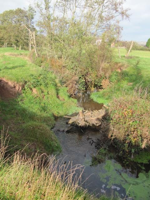
1      Contents

1.     Introduction ....................................................................................................................................... 3
2.     Condition of riverine and adjacent habitats...................................................................................... 5
3.     Water quality ..................................................................................................................................... 5
4.     Barriers to fish passage ..................................................................................................................... 6
5.     Species records .................................................................................................................................. 6
6.     Invasive non-native species ............................................................................................................... 7
7.     Previous / current projects in the Garren and Gamber Catchment .................................................. 8
8.     Potential projects / enhancement opportunities.............................................................................. 9
     8.1.      Invasive species management ................................................................................................... 9
     8.2       Water vole reintroduction......................................................................................................... 9
     8.3       Buffer strip creation ................................................................................................................ 10
     8.4       Riparian fencing and alternative drinking arrangements for livestock ................................... 10
     8.5       Managing and restoring species-rich hedgerows ................................................................... 11
     8.6       Coppicing bankside trees......................................................................................................... 11
     8.7       Pleaching and large woody debris........................................................................................... 11
     8.8       Revetment work ...................................................................................................................... 12
     8.9       Fish pass and habitat solutions ............................................................................................... 12
     8.10      Wetland creation / restoration ............................................................................................... 13
     8.11      Landowner engagement.......................................................................................................... 13
9      Conclusion ....................................................................................................................................... 14
10          Acknowledgements ..................................................................................................................... 16

                                                                             2
1. Introduction
The Wye Valley AONB Unit, with support from Natural England, commissioned this report to
investigate baseline data on habitat and water quality on the Garren and the Gamber brooks in order
to identify any potential for habitat or management improvements. It comprises the findings of the
Wye and Usk Foundation (WUF), Natural England (NE), Monnow Rivers Association (MRA),
Environment Agency (EA), Herefordshire Wildlife Trust, Caroline Hanks (Farming 4 Wildlife) and the
Wye Valley AONB. Information gathered from partner organisations is as up to date as possible.
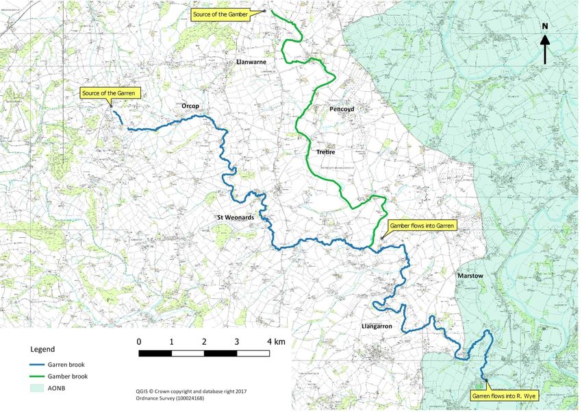
The Garren and Gamber are tributaries of the River Wye Special Area of Conservation (SAC) and are
situated in south-west Herefordshire. The Gamber starts at source just south of Wormelow Tump at
Gamber Head (SO 4929) and flows for approximately 13.6 kilometres until it reaches the Garren at
Trehumphrey (SO 5222). The source of the Garren occurs near the Welsh border at Garrendale, west
of Orcop (SO 4426). The brook flows for approximately 31km towards the south-west, reaching the
Wye near Goodrich (SO 5517). The map overleaf (Fig. 1) shows the location of the Garren and Gamber
within the wider landscape.
A section of the Garren brook is designated as a Local Wildlife Site and features plants such as
common meadow-rue (Thalictrum flavum) and water-crowfoot (Ranunculus aquatilis), with alder
(Alnus glutinosa) and willow (Salix sp.) creating a wooded margin along much of the watercourse.
Over-shading along many sections of both brooks is an issue, depriving the channel of sunlight and as
a consequence, this reduces the abundance of plant and invertebrate life available as sources of food
for larger fish and other wildlife.
The Garren and Gamber brooks are significantly influenced by local land-use, which is predominantly
intensive agriculture. Land surrounding the Garren includes large arable fields and low hedgerows
with some good quality agricultural land at risk from flooding. Sandstone makes up the underlying
geology of the Garren and is very susceptible to erosion through inappropriate farming practices. The
River Wye and its tributaries contribute towards a large, linear ecosystem which acts as an important
wildlife corridor, an essential migration route, and a key breeding area for many nationally and
internationally important species. Any improvements made to habitats and water quality along the
Garren and Gamber will also benefit the Wye into which the Garren drains.
34 Fig. 1: Map showing the extent of the Garren and Gamber brooks.
2. Condition of riverine and adjacent habitats

Below Old Forge weir, near the Garren and Wye confluence, the river habitat is mostly fast-flowing
water over a gravel riverbed, with trout and grayling present. Further upstream, deeper and slower
waters are found. Other habitat types in the vicinity of the two brooks include areas of scrub and
bramble, patches of marshy grassland and strips of broadleaved woodland.

Land use within the catchment of the Garren and Gamber includes arable farming on sandy soils
with steep slopes. Livestock, in some cases, have unrestricted access to the watercourses resulting in
bankside erosion and subsequent sediment loading. Sedimentation from farm land is a threat to
both the brooks and the Wye, contributing to increased silty conditions in-steam and fewer areas of
exposed gravel, which are important spawning sites for fish. Lost soil in-fills gravel and suffocates
fish eggs and invertebrates, contributing to population decline.

In a walkover of agricultural land in 2011, the Environment Agency conducted an assessment of
riparian habitats between Gamber Head and Llanwarne and highlighted key areas that would benefit
from increased buffer zones. These areas were deemed to be at higher risk of sediment run-off due
to their steep slopes and close proximity to the brook. At the present time, it is unclear whether or
not the recommendations for buffer strips were actually implemented so a further assessment may
need to be undertaken to assess the changes in these habitats over the past five years.

In order to reduce diffuse sediment pollution at the source, there would need to be a shift towards
less intensive land use and a focus on improving soil health and quality. Restricting livestock access
to watercourses would protect banksides from poaching and sediment loading. Riverside fencing
would also allow riparian vegetation to recover from the effects of grazing, increase and diversify
habitats and help to stabilise banks. Wider buffer strips, improved field drain management and
hedgerow planting are also to be encouraged as examples of good practice for the slowing down of
water run-off. Flooding is also a problem along the Wye. Compacted soil, drainage of peat soils in
the headwaters and the loss of hedges and woodland all leads to faster run off and higher flood
peaks.

3. Water quality

A Water Framework Directive (WFD) review of the Gamber was carried out by the Environment
Agency in 2011 and found the waterbody to be at risk from sedimentation and diffuse source
pollution – a problem that is widespread across the whole of the Gamber catchment. In 2009, all
phys-chem data including temperature, ammonia and pH, was classified as ‘High’ with the exception
of phosphate which received a ‘good’ rating. Data from 2006 gives a ‘Moderate’ classification for the
presence of aquatic invertebrates indicating that the site is being impacted by an increase in
nutrients.

A report produced by the EA in 2014 concluded that the condition of a section of the Garren, from
its source to its confluence with the Gamber, had deteriorated from ‘Good’ in 2009 to ‘Moderate’
status in 2014. This was due to periodic spikes in phosphate levels from agricultural run-off
contributing to macrophyte failure under the WFD. A review of the Garren in 2010 from its
                                                5
confluence with the Gamber to where it enters the river Wye found it to be failing due to its poor
WFD status for fish, thought to be due to a lack of habitat suitability and obstructions to migration.
This section of the Garren was also found to be suffering from heavy sedimentation as a result of
run-off from the surrounding agricultural land. In addition, a 2011 WFD fisheries investigation found
that brown trout (Salmo trutta) populations in the Garren were being limited by sedimentation
resulting from poaching and inappropriate arable farming practices.
Within the River Wye SAC and SSSI, conditions for salmon (Salmo salar) and white-clawed crayfish
(Austropotamobius pallipes) are unfavourable, with sediment levels and diffuse pollution being the
main concerns. Acidification, habitat degradation and barriers to fish migration have also added to
the decline of salmon in the catchment. In 2014 the EA and NE produced a catchment scale Nutrient
Management Plan which concluded that around 45% of phosphates in the Wye come from sewage
treatment works, 40% from agriculture and the remaining phosphates can be linked to industry and
septic tanks.
4. Barriers to fish passage
Information obtained by the Environment Agency (accurate as of November 2016) indicates several
sites along the lower stretch of the Garren (from the confluence of the Garren and Gamber to the
point at which the Garren meets the Wye) where high weirs and other obstructions are creating
considerable barriers to fish passage. Other problems include defunct sluices and boarded up by-
pass channels. Improvements to fish movement can be made by installing notches, restoring or
installing by-pass channels and lowering or removing weirs.
5. Species records
SEWBReC ran a data search within the catchment which returned only two records; firstly, a plant of
local conservation concern, elecampane (Inula helenium) near Ruxton Green and lastly, American
mink (Neovison vison) near Llangrove. Both of these records are pre-1980.
According to NBN gateway data, water vole (Arvicola amphibius) were last recorded in 1964 in
unspecified locations within SO 51 and SO 52. However, a survey of water vole in 1989 revealed
some established local populations, especially along the River Monnow and Garren brook, but it is
likely that these have followed the national trend of decline.
Sediment and nutrient pollution is a major issue affecting water quality in the Wye and as a result,
spawning grounds for salmon have been greatly affected. This is also the case in both the Garren and
Gamber with salmon populations being higher in more northern tributaries of the Wye which aren’t
as affected by sedimentation.
6Figure 2 below shows NBN species records for areas around the Garren and the Gamber.
Species Location Most recent record
American mink SO 51 2016 x2
(Neovison vison)
Badger Three Ashes 2014
(Meles meles) SO 5022
Bullhead SO 529205 2008
(Ameiurus nebulosus)
Fallow deer SO 51 2016
(Dama dama)
Otter SO 507226 2014
(Lutra lutra)
River lamprey Huntsham Bridge SO 567183 & 1996 & 1997
(Lampetra fluviatilis) Monnow river SO 453213
Roe deer SO 51 2003
(Capreolus capreolus)
Salmon SO 51 1997
(Salmo salar)
Brown trout SO 529205 2008
(Salmo trutta)
Twaite shad River Wye SO 558181 1999
(Alosa fallax)
White-clawed crayfish Monnow SO 477173 & SO 51 1986
(Austropotamobius pallipes)
Yellow mayfly SO 55950 18390 01/09/2008
(Potamanthus luteus)
Fig. 2: Data gathered from NBN Gateway detailing the most recent record of each species noted on the Garren
and Gamber brooks.
6. Invasive non-native species
Himalayan balsam (Impatiens glandulifera) was once abundant along the Garren and Gamber but a
recent Monnow Rivers Association project to manage it (‘Water Voles on the Wye’ – see below) has
seen very good results, reducing its extent to small patches along the watercourse. Its dominance
reduces the abundance of native plants and leads to exposed un-vegetated river banks during the
winter, thereby exacerbating erosion. Himalayan balsam can easily be pulled by hand before it
flowers or a herbicide can be used.
High numbers of American mink were recorded in SO 51 and SO 52 between 2005 and 2016 (NBN
Gateway, no specific location), but the species was successfully eradicated from the Garren and
Gamber as a result of trapping during the ‘Water voles on the Wye’ project.
Despite the rise in the numbers of the invasive signal crayfish (Pacifastacus leniusculus) across the
UK, there are no published records in the surrounding area, although this may be due to an absence
of reporting. There are no records of Japanese knotweed (Fallopia japonica) on NBN Gateway in the
Garren and Gamber catchment, nor did we see any while surveying.
77. Previous / current projects in the Garren and Gamber Catchment
In 2010, as part of the River Garren Access Project, the Wye and Usk Foundation created fish access
points on the Garren brook by removal of a weir and an old eel trap which blocked the river. They
also lowered ‘Forge Weir’ – the Garren’s lowest obstruction – allowing the pool to back up and fish
to pass.
The Monnow Rivers Association carried out a two year project (‘Water Voles on the Wye’) on both
the Garren and the Gamber, removing Himalayan balsam and controlling mink, with the latter being
successfully eradicated across the length of the brooks. However, funding came to an end before all
Himalayan balsam could be removed. Since the project finished in 2014, there has been no
surveying to establish the current situation regarding mink, but it is likely that their population has
once again risen.
In 2015 the EA partnered with WUF to deliver a series of improvement works on four sections of the
Garren brook which fall inside the AONB, near to its confluence with the Wye. In order to increase
light levels, heavily wooded areas were thinned and woody debris were installed by pleaching
coppiced alder and pinning it to the banks. This method also helps to increase access to fishable
swims and exposed more suitable spawning grounds by mobilising fine sediments. A pre-barrage
fish pass using stop logs containing low flow notches has been installed to increase connectivity and
allow for fish recolonization further upstream. Other improvement work involving revetment,
coppicing and fencing has been carried out successfully and modifications were made to a fish pass
to ensure functionality for all fish species.
The EA are trialling the use of technology (Sentinel satellite imagery and LIDAR data) in an evidence-
based, targeted approach to identify land parcels most at risk of soil erosion. The technology can be
used to highlight fields with a slope of more than 6 degrees and those that have been left without
cover crops over winter. Crops such as potato and maize can leave soils particularly vulnerable as
they are harvested late in the year leaving fields bare. Using this technology could help to focus
projects in areas within the Garren and Gamber catchment which are at particularly high risk of
erosion, run-off and siltation.
88. Potential projects / enhancement opportunities
8.1. Invasive species management
Flora
Himalayan balsam was seen in scattered patches throughout the length of the Garren and to a lesser
extent along the Gamber. Additionally, a dense patch of bamboo (Bambusoideae) was noted within
SO 5322. A more accurate picture of the extent of invasive plants would need to be established by
surveying at a more suitable time of year (a walkover of the catchment by the AONB was carried out
in November) and ensuring access to all land adjacent to the brooks.
American mink
Although mink control has taken place along the whole of the Garren and Gamber catchment in
recent years, additional surveys would need to be undertaken to establish current population
estimates with a view to trapping and further eradication. Monitoring numbers beyond this point
may best be carried out and maintained by volunteer groups, as has been established along the river
Monnow.
Signal crayfish control
While it proved difficult to find records of this species along the Garren or Gamber, Natural England
have suggested that the Garren brook could be a target site for a signal crayfish control programme.
8.2 Water vole reintroduction
The European water vole is the UK’s fastest declining mammal, disappearing from around 97% of its
former range due to loss of habitat and predation by American mink. Water voles are protected
under Schedule 5 of the Wildlife and Countryside Act 1981 and are also listed in the Red Data Book
for mammals. They are a priority species in the UK Biodiversity Action Plan. The species needs high
light levels and wide margins of preferably native vegetation as their food source and also as cover
from predators. Good water vole habitat consists of soft but stable banks with steep sides to allow
them to build their burrows and entrance chambers high above the water level.
The work that the Monnow Rivers Association (MRA) carried out along the Garren and Gamber has
significantly improved the habitat for water vole and laid the foundation for their possible
reintroduction. If further enhancements were carried out, there is the capacity to release water vole
back onto the Garren and Gamber brooks. As mentioned above, American mink would need to be
eradicated for a water vole reintroduction project to be successful. Improving the bankside habitat
via Himalayan balsam removal, fencing and coppicing would increase bankside vegetation diversity
and increase connectivity between sites.
9Several sections along both brooks contain suitable habitat for the release of water vole and feature
areas with sparse tree cover and wide strips of bankside vegetation over marshy grassland.
Narrower sections of slow flow and pool systems with cut off meanders are also ideal.
There is potential for the release of water vole at several sites along the Garren and Gamber with a
possible staggered release over two years. Reintroduction methods may involve ‘soft’ releases
whereby pens are dug into the ground with food provision for a period of time. This is found to be a
more effective and successful method than a ‘hard’ release. Initial estimates for breeding and
transport costs for the number of water vole required are thought to be in the region of £10k. The
use of volunteers or the acquisition of a translocation project would bring costs down.
8.3 Buffer strip creation
Soil erosion has been identified as a considerable problem within the Wye catchment, particularly
where soils are left bare over winter under certain arable regimes such as potato cropping and maize
production. Erosion of soils leads to the siltation of rivers, which is of particular concern in the Wye
SAC and the Garren and Gamber tributaries. Although not a perfect solution, the creation of buffer
strips of grassland along river systems help to intercept soil run-off and reduce the volume entering
the water courses. This intervention may also help to reduce contamination by pesticides and
fertilisers. There are a number of locations along the Garren and Gamber where riparian areas could
benefit from the introduction or extension of buffer strips, particularly those in areas adjacent to
arable fields at high risk of sedimentation by run-off, or on pasture where the river banks are
susceptible to poaching or overgrazing.
The current Countryside Stewardship scheme provides guidelines for the establishment and
management of buffer strips which include:
maintaining a 4 – 6 metre wide grass buffer strip during the first 12 months of the agreement
once the strip has been established, cut between 1 and 3m of the strip next to the crop edge
every year after 15 July
only cut the remaining width to control woody growth (leaving aside areas containing fallen
timber)
where there are hedgerow trees over 30cm in diameter at breast height, leave fallen timber
beneath the canopy, stacking any timber that obstructs management of the buffer strip
8.4 Riparian fencing and alternative drinking arrangements for livestock
In areas where livestock have unrestricted access to waterways, the riparian habitat can become
degraded. Poached soil in unfenced areas leads to bank destabilisation and greater sediment
loading. Often the watercourse becomes wider and shallower as the banks become increasingly
eroded. Excess sediment is detrimental to fish spawning habitats and reduces the range of habitats
available for other organisms such as invertebrates.
By excluding livestock, riparian fencing can help to reduce bankside erosion and lower sediment and
nutrient inputs. Over time, the reduced erosion will contribute to the narrowing and the deepening
10of the channel. Fencing allows vegetation to recover, helping to stabilise the bank and creating a
buffer zone which provides habitat and therefore increases biodiversity in these areas.
Alternative drinking facilities for livestock could take the form of designated drinking bays, or more
ideally, drinking troughs. It is important to note that the vegetation will need some management by
occasional, short-term livestock grazing or cutting. The benefits to farmers of riparian fencing
include a reduced risk of foot and leg injuries to livestock at the water’s edge and improved
biosecurity - disease organisms are prevented from spreading to other livestock downstream.
8.5 Managing and restoring species-rich hedgerows
2020 biodiversity targets for England include strategies for restoring hedgerows to ‘favourable’
condition by planting new hedges and improving the condition of existing ones. Hedgerows
consisting of native species are a priority habitat as they are a vital refuge for a variety of wildlife,
particularly in areas of intensive agriculture. Hedgerows also help to guard against soil erosion by
wind and rain by binding the soil and intercepting lost sediment. This is particularly important in
areas with large fields with fewer boundaries, as can be seen in many areas in the predominantly
arable landscape around the Garren and Gamber.
Converting fence-lines to hedgerows in vulnerable areas such as these could help to reduce erosion
from adjacent fields into the watercourse. Targeting areas on steeper slopes and on land where
hedgerow decline has been most marked would contribute to the reduction of soil erosion,
therefore helping to improve soil and water quality. Managing for tall, thick hedgerows and
conserving mature hedgerow trees should be encouraged.
8.6 Coppicing bankside trees
There are many areas along the Garren and Gamber where dense shade from tall trees is reducing
habitat quality. Bankside trees that have not been cut or coppiced in several years develop multiple
stems and lack the varied age structure that benefits a range of wildlife. Reduced light levels restrict
plant growth on the bankside and this has a detrimental impact on species diversity and also on
bankside stabilisation. Coppicing in selected areas would increase the amount of light getting
through the canopy, which would then promote the natural regrowth of bankside plants and allow
the banks to re-stabilise. This method also promotes more diverse vegetation age structure which
increases the benefit for wildlife. In some areas which are heavily shaded and the brooks are very
narrow, it wouldn’t be suitable to coppice due to the increase in light levels only being short term
and coppicing would be expensive.
8.7 Pleaching and large woody debris
Pleaching riverside tree species such as alder would have multiple benefits to riverside habitats. In
addition to the lighter, warmer conditions created by opening up the canopy, pinning felled trees to
the banksides provides cover for young fish, helps stabilise the riverbank and creates other niche
11habitats. Fine organic matter and leaf litter are also captured as the river flows through. The felling
of trees into river systems as ‘large woody debris’ has similar benefits but also diversifies the river
structure, creating small pools, shelter and areas of slower flow. Stones and gravel are deposited
here by the river, creating areas suitable for young fish. Water vole would benefit from habitat
enhancements created by the above methods.
8.8 Revetment work
If river banks are unstable due to a lack of native vegetation, the bankside is more likely to erode.
This alters the channel and can make it become wider and shallower, whilst also smothering
valuable habitat on the river bed in silt. As a consequence, the value of the river to wildlife is
reduced. Successful revetment work has already been carried out on a section of the Garren. Further
work using natural materials along the Garren and Gamber could provide additional habitat for fish
and invertebrates as well as reinforcing banksides to halt erosion.
8.9 Fish pass and habitat solutions
Projects which improve fish habitats and connectivity in the Garren and Gamber brooks will help to
increase fish populations and in turn support those in the River Wye. Enhancements to river habitats
may include the modification or removal of barriers to fish migration, stabilising banksides,
restoration of spawning habitats or enhancing fish cover.
Salmon embryos require well oxygenated water to aid their development. The presence of fine
sediment can reduce the flow of water, and sediment deposition on spawning grounds can lead to
the suffocation of embryos. To reduce fine sediment being deposited over gravel beds, there are a
number of possible remedies. Water velocities can be increased in targeted areas by narrowing the
river channel via installing stream deflectors, boulders and submerged weirs. A drawback to these
methods is that sediments would then be washed and deposited further downstream. If a habitat
has become severely degraded or lost, it may be appropriate to create new spawning habitat. If
poaching or over-shading has led to poor bankside vegetation, cover for fish may be negligible. The
installation of woody debris or the placement of boulders in the channel may offer cover for fish and
other organisms.
Bypass channels and fish passes are an option to allow fish movement around obstructions such as
weirs and dams. Along the Garren and Gamber, options for fish passes / easements (such as larinier,
pool and slot, rock ramp or pre-barrage) will need to be assessed on a site by site basis to determine
their suitability. It is worth noting that the only way improvements to fish habitats will be valuable
and worthwhile in the long run, is if they are part of a wider plan to improve the way the
surrounding land is managed. Without this catchment-scale approach, the source of the problem is
not addressed and siltation of spawning habitat will continue.
128.10 Wetland creation / restoration
Wetlands are not only important habitats for a wide variety of wildlife but they are also hugely
important for the ecosystem services they provide. Wetland habitats act as buffers for water courses
by filtering out sediments and capturing nutrients that would otherwise end up in our river systems.
For these reasons, increasing areas of wetland in land adjacent to the Garren and Gamber would be
beneficial to both brooks. Species associated with rivers would have their habitat extended and this
would provide flood control by retaining water and altering flow. Larger areas of wetland habitat can
also reduce the impact of mink predation by providing greater cover and larger habitat extent for
native species such as water vole.
There is the potential for a collaborative approach to small scale wetland restoration between land
owners in the catchment. It has been noted that there are some residual lapwing (Vanellus vanellus)
populations in this vicinity and there may be interest from landowners to increase their numbers
through habitat improvements.
8.11 Landowner engagement
Herefordshire Meadows, Caroline Hanks (Farming 4 Wildlife) and Farm Herefordshire have been
working with landowners in the catchment over a number of years. Their aim is to promote good
farming practice, healthy soils and clean water. They facilitate training days, give advice and open up
communication between landowners and other interested parties. It is advisable that any projects
going forward in the Garren and Gamber catchment involves the above organisations, where a
relationship with local landowners has already been established. It has been suggested that any
projects needing the involvement of landowners, could be advertised in the Herefordshire Rural Hub
newsletter. A local group consisting of landowners interested in habitat improvements within the
Garren and Gamber catchment could be set up to support each other and share ideas. Other
agricultural organisations such as the Herefordshire Soils Discussion Group could be contacted when
promoting projects as they are well placed to encourage landowner discussion and sharing of best
practice. There is also a real opportunity to set up a group based in the Garren and Gamber
catchment which could run in a similar way to the Soils Discussion Group. If future funding could
provide a farm adviser for the area, they could join the Farm Herefordshire partnership and be
supported to hold local events, discussion groups, meetings, and best practice demos alongside
advice on soil and water, habitat creation, species reintroduction and invasive species management.
139 Conclusion
With support from local landowners, significant improvements to riverine habitats have already
been made by WUF, MRA and the EA along the Garren and Gamber in recent years but many issues
still remain. In order to address any of the issues outlined in this report, landowner engagement and
clear communication must be a priority. In this way the root causes of these issues could be
addressed and mitigated against.
It is worth noting that information provided by partner organisations may be several years old so
conditions on the ground may well have changed.
Recommended funding opportunities currently available:
1. Dŵr Cymru Water Framework Directive Funding Scheme
Dŵr Cymru are currently providing a funding opportunity to implement the European Union’s
Water Framework Directive (WFD). It aims to support projects that improve the ecology of
the water environment. It is targeting water bodies or protected areas that are failing to
reach objectives under the WFD.
2. National Grid – VIP (Visual Impact Provision) Landscape Enhancement Initiative
Funding is available to help reduce the visual impact of National Grid high voltage electricity
infrastructure in nationally protected landscapes (AONBs and National Parks) across England
and Wales. While in some cases, views of the line may be screened or softened, in many
cases where it may not be possible to address the impacts of the electricity line directly, it
may be possible to ‘shift the balance’ of the impacts by enhancing the local environment in
other ways. The initiative is providing up to £24 million over six years (May 2016 to March
2021). National Grid pylons run through Marstow and to the south of Llangarron.
3. Countryside Stewardship Facilitation Fund
This fund supports projects that bring together farmers and landowners to improve their
local environment at a landscape scale. Priority is given to approaches which show
collaborative partnership working to achieve environmental benefits beyond what could be
achieved by individuals acting alone.
4. Heritage Lottery Fund - Landscape Partnerships Grant
Grants from £100,000 to £3,000,000 are available to help conserve habitats at landscape-
scale. It is for schemes led by partnerships of local, regional and national interests which aim
to conserve areas of distinctive landscape character throughout the UK.
5. Government agri-environment schemes
Existing funding opportunities under the current Countryside Stewardship Scheme include
the Hedgerows and Boundaries Grant and Water Capital Grants. The UK’s departure from the
EU will inevitably change the way our current agri-environment schemes look, but there may
be new opportunities in the future.
6. Section 106 / Community Infrastructure Levy (CIL) ‘Planning Gain’ agreements
Contributions for specific projects may be sought from local developers as a way of mitigating
against the effects of a development. Section 106 and CIL can be used to ensure that the new
development contributes positively to the local environment.
14Depending on the applicant, a variety of other smaller funding opportunities could also be available
from initiatives such as the Landfill Communities Fund, the Esmée Fairbairn Foundation and Tesco’s
‘Bags of Help,’ to name a few examples.
1510 Acknowledgements
Many thanks to our partners who contributed to the research, ideas and survey work within
this document:
Andrew Nixon, Herefordshire Wildlife Trust
Caroline Hanks, Farming 4 Wildlife
Dougal Ziegler and Brecht Morris, Environment Agency
Kate Speke-Adams, Wye and Usk Foundation
Lis Harris and Rachel Bosanquet, Natural England
Rob Denny, Monnow Rivers Association
Map generation:
Ordnance Survey 2017
Google Maps 2017
Biological Records provided by:
SEWBReC
NBN Gateway
16You can also read