Geodetic activities in Sweden 2014-2018 - Reports in Geodesy and Geographical Information Systems - Lantmäteriet
←
→
Page content transcription
If your browser does not render page correctly, please read the page content below
Lantmäterirapport 2018:4

Reports in Geodesy and Geographical Information Systems

               Geodetic
              activities in
                Sweden
              2014–2018

         Dan Norin, Anna B. O. Jensen, Mohammad
               Bagherbandi, Mehdi Eshagh

                       Gävle 2018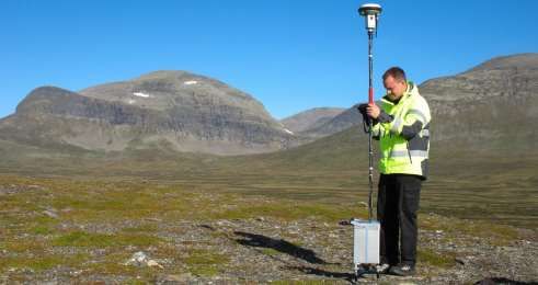
Copyright ©
2018-08-21
Authors Dan Norin, Anna B. O. Jensen, Mohammad Bagherbandi, Mehdi
        Eshagh
Typography and layout Rainer Hertel
Total number of pages 78
Lantmäterirapport 2018:4 ISSN 0280-5731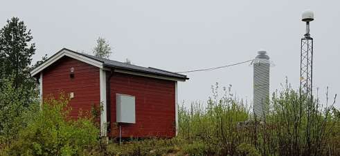
Geodetic
    activities in
      Sweden
    2014–2018

Dan Norin, Anna B. O. Jensen, Mohammad
      Bagherbandi, Mehdi Eshagh

             Gävle 2018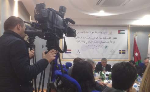
Preface
This report covers the geodetic activities at Lantmäteriet (the
Swedish mapping, cadastral and land registration authority) and at
universities in Sweden for the years 2014–2018. The report was
presented at the 18th General Assembly of the Nordic Geodetic
Commission (NKG) and it is planned to be included in the
proceedings from this meeting. The location for the assembly was
Helsinki in Finland, where it was held 3–6 September 2018. The
universities which have contributed to and participated in the
compilation of the report are:
   •   KTH Royal Institute of Technology (Kungliga Tekniska
       högskolan) in Stockholm.
   •   University of Gävle (Högskolan i Gävle).
   •   University West (Högskolan Väst) in Trollhättan.
Onsala Space Observatory at Chalmers University of Technology
(Onsala Rymdobservatorium vid Chalmers tekniska högskola) in Göteborg
has unfortunately not been able to contribute with their geodetic
activities 2014–2018 in the same way that they have done in
connection with former NKG General Assemblies, for example to the
previous one in 2014 (Norin et al., 2016). Onsala Space Observatory is
the Swedish national facility for radio astronomy. It is hosted by the
university´s Department of Earth and Space Sciences, where the
Space Geodesy and Geodynamics research group is focused on three
techniques for geodetic, geophysical and other earth oriented
applications for studying among others geodynamic phenomena and
atmospheric processes:
   •   Geodetic VLBI.
   •   Gravimetry.
   •   GNSS.
It should also be mentioned that the former Associate Professor at
KTH Arne Håkansson peacefully passed away on 26 May 2015 at the
age of 86 and that the former geodesist at Lantmäteriet as well as
national boundary inspector Åke Gustafsson peacefully passed away
on 17 May 2017 at the age of 91.

                                                                         5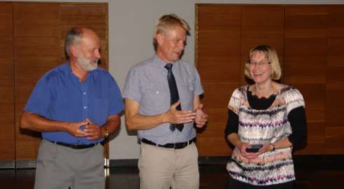
6
Geodetic activities in
    Sweden 2014–2018

         Preface                                             5

1        Geodetic activities at Lantmäteriet                 9
1.1      Introduction                                        9
1.2      Satellite positioning (GNSS)                       10
1.3      Network of permanent reference stations for GNSS
         (SWEPOS)                                           11
1.4      SWEPOS services                                    14
1.5      Reference system management – SWEREF 99            15
1.6      Reference system management – RH 2000              16
1.7      Geoid models                                       16
1.8      Gravimetry                                         18
1.9      Geodynamics                                        19
1.10     Further activities                                 20
1.10.1   Diploma works                                      20
1.10.2   Arranged workshops and seminars                    21
1.10.3   Participation in projects overseas                 22
1.10.4   Website and digital geodetic archive               23
1.10.5   Handbooks for mapping and surveying                23
1.10.6   FAMOS and the Baltic Sea Chart Datum 2000          23
1.10.7   National elevation model                           24

2        Geodetic activities at KTH                         25
2.1      Organisation and staff                             25
2.2      Education                                          26
2.2.1    Bachelor                                           26
2.2.2    Master                                             26
2.2.3    Ph.D.                                              26
2.3      Research                                           27
2.4      Outreach and dissemination                         28

3        Geodetic activities at the University of Gävle 30
3.1      Introduction                                       30
3.2      The graduate programme in Land Management and
         Land Surveying                                     30

                                                                 7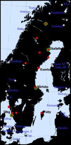
3.3      Staff, research and quality in geodesy and engineering
             surveying                                              31

    4        Geodetic activities at University West                 33
    4.1      Introduction                                           33
    4.2      Surveying engineering programme                        33
    4.3      Two directions for surveying engineering programme     33
    4.4      Staff and research in geodesy                          34

              References                                            35

    Appendix 1 – Lantmäteriet: Geodetic publications 2014–
           2018                                           38
    Appendix 1.1 – Lantmäteriet: International journals             38
    Appendix 1.2 – Lantmäteriet: Swedish journals                   41
    Appendix 1.3 – Lantmäteriet: Conference proceedings and
    compilation works                                               43
    Appendix 1.4 – Lantmäteriet: Other geodetic publications        48
    Appendix 1.5 – Lantmäteriet: Reports in Geodesy and
              Geographical Information Systems                      49

    Appendix 2 – KTH: Geodetic publications 2014–2018               51
    Appendix 2.1 – KTH: International journals                      51
    Appendix 2.2 – KTH: Swedish journals                            55
    Appendix 2.3 – KTH: Conference proceedings and compilation
             works                                                  56
    Appendix 2.4 – KTH: Other geodetic publications                 57
    Appendix 2.5 – KTH: Poster and oral presentations               57

    Appendix 3 – University of Gävle: Geodetic publications
           2014–2018                                      62
    Appendix 3.1 – University of Gävle: International journals       62
    Appendix 3.2 – University of Gävle: Conference proceedings and
             compilation works                                       65
    Appendix 3.3 – University of Gävle: Other geodetic publications 65
    Appendix 3.4 – University of Gävle: Poster and oral presentations66

    Appendix 4 – University West: Geodetic publications
           2014–2018                                                69
    Appendix 4.1 – University West: International journals          69
    Appendix 4.2 – University West: Conference proceedings and
             compilation works                                      72
    Appendix 4.3 – University West: Other geodetic publications     73
    Appendix 4.4 – University West: Poster and oral presentations   73

8
Geodetic activities in Sweden 2014–
2018
1 Geodetic activities at Lantmäteriet
1.1 Introduction
At Lantmäteriet (the Swedish mapping, cadastral and land
registration authority) the geodetic activities since the previous NKG
General Assembly in 2014 (Norin et al., 2016) have been focused on:
• The operation, expansion and services of SWEPOS™, the
Swedish national network of permanent reference stations
for GNSS1.
• The implementation and sustainability of the Swedish
national geodetic reference frame SWEREF 99 and the
national height system RH 2000 (ETRS892 and EVRS3
realisations, respectively).
• The improvement of Swedish geoid models and
renovation of the gravity network.
Some of the activities are performed within the framework of NKG4.
The geodetic work within Lantmäteriet has been based on a 10-year
strategic plan for the years 2011–2020 called Geodesy 2010, which
was released in 2011 and updated in 2015 (Lantmäteriet, 2011, 2015).
A new strategic plan will be released during 2018 (Lantmäteriet,
2018), initiated by a new national geodata strategy from 2016.
To ensure a long-term stable national geodetic infrastructure, Onsala
Space Observatory at Chalmers University of Technology in 2017
initiated discussions concerning funding from Lantmäteriet of the
geodetic activities at the observatory. This will start from 2019 and is
an important step in implementing the UN5 resolution on “A Global
Geodetic Reference Frame for Sustainable Development” in Sweden.
1
GNSS = Global Navigation Satellite Systems
2
ETRS = European Terrestrial Reference System
3
EVRS = European Vertical Reference System
4
NKG = Nordiska Kommissionen för Geodesi (Nordic Geodetic Commission)
5
UN = United Nations
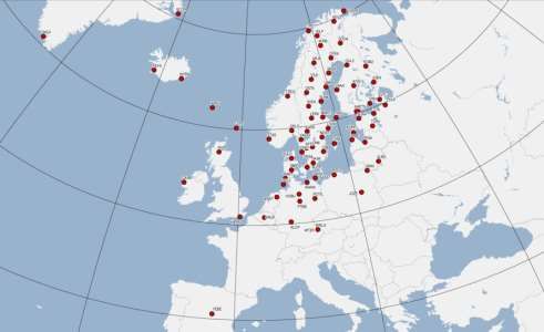
91.2 Satellite positioning (GNSS)
Lantmäteriet operates the NKG AC6 for EPN7 in cooperation with
Onsala Space Observatory. The NKG AC contributes with weekly
and daily solutions using the Bernese GNSS Software version 5.2.
The EPN sub-network processed by the NKG AC consists of 90
reference stations concentrated to northern Europe, see Figure 1.1.
This means that 31 stations have been added to and 2 stations have
been redrawn from the NKG AC sub-network since the previous
NKG General Assembly four years ago. NKG has through
Lantmäteriet been represented at the ninth and tenth EUREF8 AC
Workshops held in 2015 and 2017.
Figure 1.1: The NKG EPN AC sub-network of 88 permanent reference
stations for GNSS. Source: www.epncb.oma.be.
The NKG GNSS analysis centre project was declared fully
operational in April 2017 and it is chaired by Lantmäteriet (Lahtinen
et al., 2018). The project aims at a dense and consistent velocity field
in the Nordic and Baltic area. Consistent and combined solutions are
produced based on national processing following the EPN analysis
guidelines. A reprocessing of the full NKG network of reference
stations including all Nordic and Baltic countries for the years 1997–
2016 has been completed and the time series analysis has been
finalised during 2018.
In June 2016, Lantmäteriet became one of the analysis centres in E-
GVAP9, where Lantmäteriet manages the data processing to provide
near-real-time zenith total delay of GNSS signals in the troposphere
6
AC = Analysis Centre
7
EPN = EUREF Permanent Network
8
EUREF = the IAG Reference Frame Subcommission for Europe
9
E-GVAP = the EUMETNET EIG GNSS water vapour programme
10(Lindskog et al., 2017 and Ning et al., 2016). Both the Bernese GNSS
Software version 5.2 and GIPSY/OASIS II version 6.2 are used for
the processing. The latter software uses the PPP10 strategy and
approximately 700 reference stations in total situated mainly in
Sweden, Finland, Norway and Denmark are processed.
The EGNOS11 RIMS12 that was inaugurated at Lantmäteriet in Gävle
already during 2003 has been successfully supported by Lantmäteriet
since then.
1.3 Network of permanent reference
stations for GNSS (SWEPOS)
SWEPOS™ is the Swedish national network of permanent GNSS
stations operated by Lantmäteriet, see Figure 1.2 (Lilje et al., 2014).
The SWEPOS website is available on www.swepos.se
(www.lantmateriet.se/swepos).
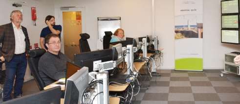
Figure 1.2: The SWEPOS control centre at the headquarters of
Lantmäteriet in Gävle during a study visit in 2016 by Mr Peter Eriksson,
the Swedish Minister for Housing and Digital Development. Photo: Britt-
Louise Malm.
The purposes of SWEPOS are:
• Providing single- and dual-frequency data for relative
GNSS measurements.
• Providing DGNSS13 corrections and RTK14 data for
distribution to real-time users.
• Acting as the continuously monitored foundation of
SWEREF 99.
10
PPP = Precise Point Positioning
11
EGNOS = European Geostationary Navigation Overlay System
12
RIMS = Ranging and Integrity Monitoring Station
13
DGNSS = Differential GNSS
14
RTK = Real Time Kinematic
11• Providing data for geophysical research and for
meteorological applications.
• Monitoring the integrity of the GNSS systems.
SWEPOS uses a classification system of permanent reference stations
developed within the NKG (Engfeldt et al., 2006). The SWEPOS
stations belong either to class A or class B, where class A meets the
highest demands.
Figure 1.3: Sveg is a SWEPOS class A station. It has both a new
monument (established in 2011) and an old monument (from 1993).
By the time for the 18th NKG General Assembly in September 2018
SWEPOS consisted of totally 401 stations (41 class A stations and 360
class B ones), see Figures 1.3 and 1.4.
Figure 1.4: Gustavsberg is a SWEPOS class B station with a roof-mounted
GNSS antenna mainly established for network RTK purposes.
This means that the total number of SWEPOS stations has increased
with 96 stations since the previous NKG General Assembly, see
Figure 1.5.
12Figure 1.5: The SWEPOS network by the time for the previous NKG
General Assembly in 2014 to the left and by the time for the 18th NKG
General Assembly in September 2018 to the right. Squares indicate class A
stations and dots indicate class B ones. Stations in neighbouring countries
and from other service providers used in the SWEPOS Network RTK
Service are also marked.
The class A stations are built on bedrock and have redundant
equipment for GNSS observations, communications, power supply,
etc. Class B stations are mainly established on top of buildings for
network RTK purposes. They have the same instrumentation as class
A stations (dual-frequency multi-GNSS receivers with antennas of
Dorne Margolin choke ring design), but with somewhat less
redundancy. All SWEPOS stations have in recent years been
upgraded to track the modernised GPS signals and the signals from
the new GNSS systems Galileo and BeiDou.
The 21 original class A stations have two kinds of monuments; the
original concrete pillar as well as a newer steel grid mast, see Figure
1.3. The new monument is equipped with individually calibrated
GNSS antennas and radomes of the type LEIAR25.R3 LEIT.
The seven SWEPOS stations Onsala, Mårtsbo, Visby, Borås,
Skellefteå, Vilhelmina and Kiruna (ONSA, MAR6, VIS0, SPT0, SKE0,
VIL0 and KIR0), which all are original class A stations, have since the
very beginning been included in EPN. The new monuments on 20 of
the 21 original class A stations mentioned above have also become
EPN stations during 2014–2016. Daily and hourly data are delivered
13from all 27 stations and real-time (EUREF-IP) data (1 Hz) are
delivered from seven stations. The new monument for the last
original SWEPOS station is expected to be included in EPN later.
Onsala, Mårtsbo, Visby, Borås and Kiruna are also included in the
IGS15 network, as well as three of the new monuments (ONS1, MAR7
and KIR8). These three stations also contribute to the IGS-MGEX16
pilot project, which has been set-up to track, collate and analyse all
available GNSS signals.
1.4 SWEPOS services
SWEPOS provides real-time services on both metre level (DGNSS)
and centimetre level (network RTK), as well as data for post-
processing in RINEX17 format. A transition from RINEX 2 to RINEX 3
is ongoing and the plan is to have RINEX 3 fully implemented for all
SWEPOS stations during 2018. An automated post-processing service
which utilises the Bernese GNSS Software is also available. Version
5.2 of the software has been used since 2015 and from 2016 the
service takes advantage of both GPS and GLONASS. A SWEPOS
user group consisting of representatives from governmental and
non-governmental organisations as well as from the private sector
supports the development of SWEPOS and its services.
The SWEPOS Network RTK Service reached national coverage in
2010 and it has supplied RTK data for both GPS and GLONASS since
April 2006. Galileo as well as GPS L5 and L2C signals were
implemented in the service on 1 February 2018. The implementation
of Galileo was preceded by extensive and successful test
measurements. Studies of the impact from hardware biases from
code and phase biases in multi-GNSS positioning are also going on
(Håkansson, 2017 and Håkansson et al., 2017)
Since data from permanent GNSS stations are exchanged between
the Nordic countries, good coverage of SWEPOS network RTK
service has been obtained also in border areas and along the coasts.
Several stations from SATREF in Norway and Styrelsen for Data-
forsyning of Effektivisering (Agency for Data Supply and Efficiency)
in Denmark are included together with stations from private
operators in Norway, Denmark, Finland, Germany as well as
Sweden.
By the time for the 18th NKG General Assembly in September 2018,
the service had approximately 3,900 subscriptions, which means
some 1,500 additional users since the previous NKG General
Assembly four years ago.
15
IGS = International GNSS Service
16
IGS-MGEX = IGS Multi-GNSS Experiment
17
RINEX = Receiver Independent EXchange format
14Lantmäteriet has also signed cooperation agreements with four
international GNSS service providers, using GNSS data from
SWEPOS stations for their own services. This is done to increase the
use of SWEPOS data as well as optimising the benefits of the
geodetic infrastructure.
A general densification of the SWEPOS network started 2010 with
the main purpose to improve the performance of the network RTK
service. The establishment of new stations is since 2017 on a little
lower level. More comprehensive densifications have also been
performed in some areas to meet the demands for machine guidance
in large-scale infrastructure projects as well as in collaboration with
some municipalities.
SWEPOS also offers a single frequency DGNSS Service as a
supplement to the network RTK service. The service is since 2016, in
line with some other national geographical data from Lantmäteriet,
available as open data. Both services are utilising Trimble Pivot
Platform GNSS Infrastructure Software and are operating in virtual
reference station mode.
1.5 Reference system management –
SWEREF 99
SWEREF 99 has been used as the national geodetic reference frame in
Sweden since 2007 and it was adopted by EUREF as the Swedish
realisation of ETRS89 at the EUREF 2000 symposium in Tromsö
(Jivall & Lidberg, 2000). It is defined by an active approach through
the 21 original SWEPOS stations, hence relying on positioning
services like the network RTK service. All alterations of equipment
and software as well as movements at the reference stations will in
the end affect the coordinates.
To be able to check all alterations mentioned above, approximately
300 nationally distributed passive so-called consolidation points are
used. They are remeasured with static GNSS in a yearly programme
with 50 points each year. The main part of the consolidation points is
still existing so-called SWEREF points established already with the
beginning in 1998. In 2017, a reprocessing of all measurements was
performed. All measurements have been done for 2x24 hours using
choke ring antennas, where the original processing was done in the
Bernese GNSS software and the reprocessing 2017 was done in both
the Bernese GNSS software and in the GAMIT software. The
outcome will be used to analyse the stability of SWEREF 99 and has
been used to define the SWEREF 99 component in the fit of the
NKG2015 geoid model to SWEREF 99 and RH 2000 (see Section 1.7).
Station dependent errors at the SWEPOS stations are limiting factors
for height estimation in SWEREF 99. In order to investigate this,
station calibration campaigns – in situ calibrations – have been
15carried out on a selection of the original SWEPOS stations (Lidberg et
al., 2016).
The work regarding the implementation of SWEREF 99 among
different authorities in Sweden, such as local ones, is still not
finalised. By the time for the previous NKG General Assembly four
years ago, 264 of the 290 Swedish municipalities had finalised the
process to replace their old reference frames with SWEREF 99, while
four municipalities still remain to date.
1.6 Reference system management –
RH 2000
The third precise levelling of the mainland of Sweden lasted 1978–
2003, resulting in the new national height system RH 2000 in 2005.
The network consists of about 50,000 benchmarks, representing
roughly 50,000 km double run precise levelling measured by
motorised levelling technique.
Since the beginning of the 1990s, a systematic inventory/updating of
the network is continuously performed. When an update is required,
the required precise levelling is done through procurement
procedures, which is also the situation for the remeasurements of the
300 consolidation points described in Section 1.5. Precise levelling
work has also been carried out to connect tide gauges to the national
levelling network and for height determination of surface levels of
the large lakes in Sweden.
The implementation of RH 2000 among different authorities in
Sweden is in progress (Kempe et al., 2014). About 93% of the 290
Swedish municipalities have, mainly in cooperation with
Lantmäteriet, started the replacement of their local height systems
with RH 2000. So far 247 municipalities have finalised the
replacement for all activities, which is 88 more than by the time for
the previous NKG General Assembly four years ago.
1.7 Geoid models
According to Geodesy 2010, the ultimate goal is to compute a 5-mm
geoid model (68%) by 2020. To reach this goal – to the extent that it is
realistic – the following activities have been carried out and are still
ongoing:
• Work with the new national gravity reference frame RG 2000
finalised in the beginning of 2018 (see Section 1.8).
• New detail gravity observations collected with relative
gravimeters of the brand Scintrex CG5 with the purpose to fill
gaps or replace old data of bad quality (e.g. on Lake Vänern
and in the rough Swedish mountains in the north-west part of
the country, see Figure 1.6).
16• Improvement of the national GNSS/levelling dataset, where
the core of the new updated dataset is the SWEREF and
consolidation points (see Section 1.5) for which accurate
levelled heights are available in RH 2000.
• Computation of NKG2015, which is the new common
gravimetric quasigeoid model over the Nordic and Baltic
countries released in October 2016 (Ågren et al., 2016).
Figure 1.6: More than 3,400 new relative gravity measurements have been
performed in Sweden since 2010. The heights of the locations are determined
by network RTK measurements. Photo: Örjan Josefsson.
The work with NKG2015 was performed in the geoid model project
of the NKG Working Group of Geoid and Height Systems. An
update of the NKG gravity database for the whole Nordic-Baltic area
and a creation of a new NKG GNSS/levelling database and a
common DEM18 were also included in the project. Independent
computations for NKG2015 were first made by five computation
centres – from Sweden, Denmark, Finland, Norway and Estonia –
using different regional geoid computation methods, software and
set-ups. The modelling method utilised for the final model, the Least
Squares Modification of Stokes’ formula with additive corrections,
was chosen based mainly on the agreement to GNSS/levelling.
GNSS/levelling evaluations show that NKG2015 is a significant step
forward, not only compared to previous NKG geoid models, but also
with respect to other state-of-the-art ones covering the whole Nordic-
Baltic area, e.g. EGM2008, EGG2015 and EIGEN-6C4.
The new Swedish national geoid model SWEN17_RH2000 was
released in October 2017. It was computed by adapting the
gravimetric NKG2015 geoid model (slightly corrected over Sweden
with some new Swedish data) to the GNSS/levelling dataset by
18
DEM = Digital Elevation Model
17adding a smooth residual surface computed by Least Squares
Collocation. The standard uncertainty of SWEN17_RH2000 is
estimated by cross validation to 8–10 mm on the Swedish mainland
and on the islands of Öland and Gotland. This is a significant step
forward compared to the old model SWEN08_RH2000, but still more
work is required to reach the ultimate 5-mm goal.
1.8 Gravimetry
Absolute gravity observations have been carried out at 14 Swedish
sites since the beginning of the 1990s, see Figure 1.7.
All sites, except for Göteborg
(Gtbg) which no longer is in use,
have been observed by
Lantmäteriet since 2007. The
observations have been carried
out with Lantmäteriet’s absolute
gravimeter (Micro-g LaCoste
FG5X – 233), where the upgrade
from FG5 to FG5X was done in
autumn 2016. The objective be-
hind the investment was to ensure
and strengthen the observing
capability for long-term
monitoring of the changes in the
gravity field due to the
Fennoscandian GIA19.
All Swedish sites are co-located
with SWEPOS stations with the
exception for Göteborg (Gtbg).
Ratan, Skellefteå, Smögen, Visby
and Onsala are co-located with
tide gauges. Onsala is also co-
located with VLBI20.
Absolute gravity observations are Figure 1.7: There are 14 absolute
also performed abroad, mainly in gravity sites (for FG5/FG5X) in
the Nordic countries. They have Sweden marked with red squares in
however during the last four-year- the map. Absolute gravity sites in
period been limited to gravimeter neighbouring countries are marked
intercomparisons (one in Belval with grey circles. The four sites
with time series more than 15 years
and one in Wettzell), which now
long have a green circle as
means that totally eight such com-
background to the red square.
parisons have been carried out.
19
GIA = Glacial Isostatic Adjustment
20
VLBI= Very Long Baseline Interferometry
18In the beginning of 2018, the new Swedish gravity reference frame
RG 2000 became official (Engfeldt et al., 2018). The reference level is
as obtained by absolute gravity observations according to
international standards and conventions. It is a zero-permanent tide
system in post-glacial rebound epoch 2000. RG 2000 is realised by the
14 Swedish absolute gravity sites, 96 A10 stations (measured by
IGiK21) and some 200 stations observed with relative gravimeters.
The superconducting gravimeter at Onsala Space Observatory
installed during 2009 is regularly calibrated by Lantmäteriet’s
FG5/FG5X, latest in June 2018, which was the seventh performed
calibration.
1.9 Geodynamics
The main purpose of the repeated absolute gravity observations of
Lantmäteriet is to support the understanding of the physical
mechanisms behind the Fennoscandian GIA process. One key
parameter here is the relation between gravity change and geometric
deformation (Olsson, 2015).
Research regarding the 3D geometric deformation in Fennoscandia
and adjacent areas is foremost done within the BIFROST22 effort.
Reprocessing of all observations from permanent GPS stations is a
continuous activity and velocity fields are produced based on the
GAMIT/GLOBK, GIPSY and the Bernese GNSS software.
A new land uplift model called NKG2016LU substituted the older
model NKG2005LU on 30 June 2016. The new model is developed as
a combination and modification of a mathematical (empirical) model
of Olav Vestøl and a geophysical model developed within NKG
called NKG2016GIA_prel0306. It delivers both vertical and
horizontal motions, as well as gravity-rates-of-change and geoid
change. Current efforts aim at providing reliable uncertainty
estimates and a submission of a final publication for peer review. The
uncertainty of the geophysical model NKG2016GIA_prel0306 is
calculated based on the spread of well-fitting GIA models to the
observations within the 1-sigma range of the best-fitting GIA model,
see Figure 1.8.
A new 3D velocity model for northern Europe called NKG_RF17vel
is currently in preparation. The vertical part is based on
NKG2016LU, while the horizontal motions are generated from an
updated geophysical model preliminary named
NKG2016GIA_prel0907.
21
IGiK = Institute of Geodesy and Cartography, Poland
22
BIFROST = Baseline Inferences for Fennoscandian Rebound Observations Sea level and
Tectonics
19Figure 1.8: Uncertainty of the geophysical model NKG2016GIA_prel0306.
Lantmäteriet has also been involved in other activities related to
geodynamics:
• Participation in the EUREF working group on Deformation
models, which aims at obtaining a high-resolution velocity
model for Europe and adjacent areas and significantly
improving the prediction of the time evolution of coordinates.
• Contribution during 2015–2017 with global GIA corrections
for gravity missions such as GRACE, via a Service Level
Agreement to the EU23-financed Horizon 2020 project
EGSIEM24.
• Contribution to geodynamic studies regarding the
reactivation of faults due to GIA (Brandes et al., 2015, 2018).
1.10 Further activities
1.10.1 Diploma works
During the period 2014–2018 totally 11 diploma works have been
performed at Lantmäteriet by students from KTH25, Stockholm
University, the University of Gävle and University West (not all
published). They have mainly been focused on GNSS and to a large
extent the SWEPOS services.
23
EU = European Union
24
EGSIEM = European Gravity Service for Improved Emergency Management
25
KTH = Kungliga Tekniska högskolan (Royal Institute of Technology)
201.10.2 Arranged workshops and seminars
In cooperation with Chalmers University of Technology, the 17th
NKG General Assembly was arranged in Göteborg 1–4 September
2014, see Figure 1.9. It gathered 100 participants with additional 20
participating in the seminar co-arranged one of the days with the
Nordic Institute of Navigation and the Swedish Board of Radio
Navigation.
Figure 1.9: At the 17th NKG General Assembly, which was held in
Göteborg in 2014, the former and the new professor in Geodesy at KTH Lars
E. Sjöberg (left) and Anna Jenson (right) were honoured by Jan Johansson of
Chalmers University of Technology. Photo: Holger Steffen.
The NKG Summer School gathering 80 participants was arranged in
Båstad 29 August–1 September 2016 and an NKG land uplift
workshop was arranged in December 2016. The NKG2016LU land
uplift model was introduced during the land uplift workshop and
further steps in NKG model developments were also discussed.
Chalmers University of Technology arranged the European
Navigation Conference 2018 (ENC 2018) in Göteborg 14–17 May 2018
in cooperation with Lantmäteriet and RISE Research Institutes of
Sweden.
For Swedish GNSS users, seminars were arranged in Gävle in
October 2015 and October 2017. The aim of these seminars held every
second year is to highlight the development of GNSS techniques,
applications of GNSS and experiences from the use of GNSS. Many
locally organised seminars have also had key speakers from
Lantmäteriet, who have informed about e.g. SWEPOS, SWEPOS
services and the implementation of SWEREF 99 and RH 2000.
Lantmäteriet is also giving courses in e.g. geodetic reference frames
and GNSS positioning.
21Among meetings which have taken place in Gävle, a meeting with
the EUREF Technical Working group in March 2014 can be
mentioned.
1.10.3 Participation in projects overseas
Lantmäteriet are involved in several projects abroad. Some projects
have been organised through the state-owned company
Swedesurvey, but since 2017 all activities are operated by
Lantmäteriet. Many projects have a geodetic part and typical
components are development of the geodetic infrastructure and
implementation of modern surveying techniques based on GNSS.
Countries which geodetic personnel have visited for assignments
over the last four years are Albania, Belarus, Bosnia and
Herzegovina, Georgia, Ghana, Jordan (see Figure 1.10), Kosovo,
Republic of Macedonia, Rwanda and Serbia.
Figure 1.10: The mission in the EU Twinning project in Jordan was to
enhance the technical and administrative capacities of the Department of
Lands and Survey with the main purpose to reduce the discrepancies
between the physical reality and the graphical cadastral information. Photo:
Dan Norin.
Besides the projects overseas, Lantmäteriet has also been represented
and involved in different international seminars and working
groups. Mikael Lilje is since 2017 one of the vice presidents of FIG26
and Martin Lidberg is since 2012 a member of EUREF Governing
Board. Lantmäteriet has contributed to the UN resolution on “A
Global Geodetic Reference Frame for Sustainable Development”
being adopted by the General Assembly in February 2015 and the
26
FIG = Fédération Internationale des Géomètres (International Federation of Surveyors)
22UN Subcommittee on Geodesy Focus Group on Education, Training
and Capacity Building is headed by Sweden (Mikael Lilje).
Lantmäteriet supports the management of the geodetic UNESCO27
World Heritage Struve Geodetic Arc, both nationally and
internationally, and Dan Norin is since 2008 the Swedish
representative in Struve Geodetic Arc Coordinating Committee.
1.10.4 Website and digital geodetic archive
The Lantmäteriet website (www.lantmateriet.se/geodesi) contains
extensive geodetic information. Here also transformation parameters
and geoid models are easily and freely accessible.
Lantmäteriet has a digital geodetic archive with descriptions of
national control points and their coordinates and heights etc., which
has been accessible through a website since October 2007. The users
are several hundreds and can since 2018 get the information without
any fee. Large efforts have also been made to make the old analogue
archive and the geodetic library organised and secure for the future.
1.10.5 Handbooks for mapping and surveying
Lantmäteriet has published a series of handbooks for mapping and
surveying called HMK (“Handbok i mät- och kartfrågor”), with the
aim to contribute to an efficient and standardised handling of
surveying and mapping issues in Sweden. The handbooks are
divided into two main parts, geodesy and geodata capture. Geodetic
applications are covered in five documents with the most recent
versions published in 2017:
• Geodetic infrastructure.
• Control surveying.
• Terrestrial detail surveying.
• GNSS-based detail surveying.
• Support for tendering and choice of surveying methods.
1.10.6 FAMOS and the Baltic Sea Chart Datum 2000
Lantmäteriet has since 2014 been engaged in parts of the ongoing EU
project FAMOS28, which has the main purpose to increase the safety
of navigation in the Baltic Sea:
• Improvement of navigation and hydrographic surveying with
GNSS-based methods.
• Support to the introduction of the common Baltic Sea Chart
Datum 2000 (EVRS with land uplift epoch 2000.0) in the Baltic
Sea by 2020.
27
UNESCO = United Nations Educational, Scientific and Cultural Organisation
28
FAMOS = Finalising Surveys for the Baltic Motorways of the Sea
23• Improvement of the geoid model in the Baltic Sea area, which
will provide an important basis for future offshore navigation.
To reach the goal of an improved Baltic Sea geoid model, new marine
gravity data are collected. In support to this activity, Lantmäteriet
has procured a ZLS marine gravimeter delivered in April 2017.
1.10.7 National elevation model
Lantmäteriet is responsible for the production of a new Swedish
national elevation model. The mainly used method for the data
capture is airborne laser scanning and the production started in July
2009. The project is almost finalised, leaving a few small spots of the
Swedish territory in the mountainous part unscanned.
242 Geodetic activities at KTH
2.1 Organisation and staff
At KTH – Kungliga Tekniska högskolan – a number of changes have
happened with “KTH-Geodesy” during the four past years.
By 1 January 2015, KTH-Geodesy became an independent
organisational and economic unit called Division of Geodesy and
Satellite Positioning. The new division belonged to the Department
of Urban Planning and Development, but was moved to the
Department of Real Estate and Construction Management by
1 January 2018. In connection with the re-organisation, KTH-
Geodesy also moved physically to a brand-new building,
Teknikringen 10B, still at the main KTH campus in Stockholm.
Head of the new Division of Geodesy and Satellite Positioning in
January 2015 was Anna Jensen, who was appointed as professor in
September 2014 following the retirement of Lars Sjöberg. Further,
two associate professors; Milan Horemuz and Huaan Fan, as well as
one researcher Mohammad Bagherbandi hold permanent positions
in the division. Jonas Ågren, who is employed at Lantmäteriet in
Sweden, was appointed docent at KTH in 2016. The number of Ph.D.
students has varied between four and six during the period. The
division also employs ad hoc (teaching) assistants, has hosted an
intern from Greece as well as a Syrian refugee who worked as
trainee, both for three months in 2017. For shorter time periods the
division also hosted two Ph.D. students from Kazakhstan funded by
EU Erasmus+ as well as a visiting professor.
During 2014–2018 the division has been going through an
economical revision to reduce costs. This induced e.g. a reduction of
travels and conference participations, a reduction of the geodetic
library, a reduction of the instrument storage room from 80 to 40
square metres, and a gradual transition towards more rental than
ownership of geodetic instruments for teaching. Also, all Ph.D.
students must now be fully funded to be admitted.
252.2 Education
2.2.1 Bachelor
KTH-Geodesy mainly contributes with teaching in geodetic
surveying techniques, map projections and reference systems in year
1 and 3 of Degree Programme in Civil Engineering and Urban
Management (Swedish: Civilingenjörsutbildning i
samhällsbyggnad). A total of around 150 students are enrolled in this
programme and 5–10 of these choose to specialise in Geodesy and
Geoinformatics in year 3.
To a smaller degree, KTH-Geodesy also contributes to the bachelor in
Constructional Engineering and Design with courses in geodetic
surveying techniques, laser scanning and 3D building modelling.
2.2.2 Master
At the master level, KTH-Geodesy contributes to the master
programme Transport and Geoinformation Technology with courses
in GNSS, laser scanning, geodata quality and adjustment theory. The
master programme has a total of around 40 students and 2–5 of these
do their master thesis in geodesy. During 2014–2018 the most
popular topics for master theses have been laser scanning in various
applications, sensor integration, geodetic aspects of BIM29 and
geodata quality issues. All master theses are carried out in
cooperation with private companies or governmental organisations.
To a smaller degree, KTH-Geodesy contributes to the master in
Aerospace Engineering with a GNSS course and co-supervision of
master theses.
2.2.3 Ph.D.
Ph.D. students at KTH-Geodesy are enrolled in the Ph.D. programme
in Geodesy and Geoinformatics with specialisation in Geodesy.
During 2014–2018, the specialisation in geodesy has been
significantly revised to meet new administrative requirements, but
also to modernise the curriculum and broaden the scope of the Ph.D.
courses as a whole. The new programme was approved by KTH in
May 2017. A total of eight Ph.D. students have been enrolled during
2014–2018, where four have completed their studies (Ssengendo,
2015, Abrehdary, 2016, Alizadeh-Khameneh, 2017 and Shafiei Joud,
2018). Four Ph.D. students are presently enrolled (June 2018).
29
BIM = Building Information Modelling
262.3 Research
Research at KTH-Geodesy is done partly by the staff being
permanently employed without external funding, and partly within
the frame of externally funded research projects where most of the
funding is used for salaries for Ph.D. students.
Research topics are physical geodesy, satellite gravimetry, GNSS-
based positioning and navigation, atmospheric effects on GNSS
satellite signals, geodetic reference systems and applications,
geodetic surveying and theory of errors, integration of GNSS and
terrestrial surveying techniques, geodynamics, laser scanning, and
geodata quality.
External funding for research projects at KTH-Geodesy during 2014–
2018:
• A New Vertical Geodetic Datum for Uganda, funded by
SIDA30, 2010–2015.
• Optimisation of Geodetic Deformation Networks, funded by
Formas, led by KTH-Geodesy, 2012–2015.
• Modelling the Earth’s Crust by Combining GOCE, Terrestrial
Gravity and Seismic Data, funded by Swedish National Space
Board, led by KTH-Geodesy, 2013–2016.
• Development of Geodetic Surveying Methods for
Archaeological Studies in the Arctic. Funded by the Tryggve
Rubin Foundation, led by KTH-Geodesy, 2016–2017.
• Climate Change Detection by Taking Advantage of a Future
Satellite Mission: GRACE Follow-On, funded by Proficio
Foundation, led by KTH-Geodesy, 2016–2017.
• Industrial Thinking through the Full Value Chain in Coupling
Geodesy, Geodata Quality and BIM, funded by the Swedish
Transport Administration, led by KTH-Geodesy, 2017–2021.
• Data Quality and Data Responsibility in the Built
Environment, funded by Smart Built Environment and
Formas, led by KTH-Geodesy, 2017–2019.
Also during 2014–2018 KTH-Geodesy has participated in the
following projects funded by the EU Tempus and Erasmus+
programmes:
• Modernising Geodesy Education in Western Balkan with
Focus on Competences and Learning Outcomes, led by KTH-
Geodesy, 2015–2018.
• Development of a New Geodesy Master Programme in
Kosovo, led by KTH-Geodesy, 2013–2016.
• Geodesy and Geoinformatics for Sustainable Development in
Jordan, led by KTH-Geodesy, 2017–2020.
30
SIDA = Swedish International Development Cooperation Agency
27• Innovation and Entrepreneurship in Engineering Education,
led by KTH-Geodesy, 2016–2019.
• Interdisciplinary Reform in Tourism Management and
Applied Geoinformation, led by Polytechnical University of
Valencia, Spain, with KTH-Geodesy as project partner, 2016–
2019.
• Doctoral studies in GeoInformation Science, led by Obuda
University, Hungary, with KTH-Geodesy as project partner,
2017–2020.
All staff members of KTH-Geodesy also contribute to review of
scientific papers, participate in editorial boards of international
scientific journals, act as opponent and committee members at Ph.D.
defences, perform review of research proposals etc.
2.4 Outreach and dissemination
Outreach and dissemination has been important for KTH-Geodesy
during 2014–2018 and this involved a large number of external
activities with the Swedish geodetic community as well as internal
obligations in committees and boards within the university.
Examples of external activities by KTH-Geodesy:
• Cooperation with the Vasa museum; deformation monitoring
of the Vasa-ship twice yearly.
• Cooperation with the company Trimtec on continued
education in measurement uncertainty and GNSS for
professionals in Sweden, several one-day courses have been
held every year since 2012.
• Summer schools in physical geodesy for international
students.
• A seminar series on geodesy and BIM arranged in cooperation
with the Swedish Transport Administration with two
seminars per year since 2016.
• Presentations at national conferences, seminars and
workshops, for instance Kartdagarna (the Swedish Mapping
days) and Geodesidagarna (the Surveying Days).
• Distribution of a newsletter in Swedish three times per year to
Swedish geodesists, land surveyors and survey technicians.
• Consulting for private and public organisations.
Also, during 2014–2018, KTH-Geodesy has contributed with
members to working groups within NKG, a member of the board of
the Nordic Institute of Navigation and a Swedish representative in
the European Commission working group on the Galileo
Commercial Service.
Examples of internal tasks at KTH undertaken by staff of KTH-
Geodesy:
28• Programme responsible for the master in Transport and
Geoinformation Technology.
• Director of studies of the Geo-IT specialisation of education at
the School of Architecture and Built Environment.
• Member of the KTH Scholarship council.
• Vice-chair of the Recruitment Committee of the School of
Architecture and Built Environment.
• Deputy director of the KTH Space Centre.
• Member of the KTH Employment Committee.
• Member of the Strategic Council of the ABE school.
• Programme responsible for the research education (Ph.D.) in
Geodesy and Geoinformatics.
• Member of the Docent committee of the ABE school.
Also on 15 September 2017 we celebrated the 100-year birthday of
late Prof. Arne Bjerhammar at KTH. His contributions to geodesy in
Sweden, and internationally, are significant, so the day was
celebrated with lectures and a reception for around 50 invited
people; mainly former colleagues and Ph.D. students of Bjerhammar
as well as his daughters and their families.
293 Geodetic activities at the University
of Gävle
3.1 Introduction
The Department of Industrial Development, IT and Land
Management at the University of Gävle (HiG, www.hig.se) offers
graduate and postgraduate education as well as performs research in
geodesy, engineering surveying, geomatics, GIS31 and built
environment processes.
3.2 The graduate programme in Land
Management and Land Surveying
In 2009 the existing graduate programme in Geomatics was
comprehensively revised and at the same time renamed to the more
appropriate Land Management/Land Surveying (LM/LS)
programme. The two specialisations, LM and LS, share several
courses which are of importance for both of them – such as surveying
courses which are related to geodata capturing in 3D using
terrestrial, aerial and satellite-based geodetic sensors. The LM/LS
programme contributes with new knowledge/methods utilising
geospatial information.
The LM/LS graduate programme was reviewed during 2013 by
UKÄ32 and received, as the only Swedish programme within the
area, the highest rank “Very high quality”.
We have also developed a new two-year master programme in
Geospatial Information Science since 2016. The idea of the new
master programme is to create opportunities for our existing
bachelor programmes (IT/GIS, land surveying, land management,
urban planning and existing one-year master programme in
Geomatics) to proceed to postgraduate studies in Geospatial
Information Science. By developing and deepening existing
knowledge and also providing new knowledge in related fields, the
student can acquire knowledge and skills that can be used directly in
the Swedish and international labour market, as well as qualifying
31
GIS = Geographic Information Systems
32
UKÄ = Universitetskanslersämbetet (Swedish Higher Education Authority)
30for further research studies. In the programme, new courses have
been developed in GIS application and applied geodesy.
HiG has during 2018 applied at UKÄ for a permission to also
establish a five-year “Master of Science (Civilingenjörsexamen)”
programme in geospatial science. “Master of Science
(Civilingenjörsexamen)” programmes in Sweden are still very
prestigious and corresponds to the German (and others) “diplom-
ingenieur”. Further, “Master of Science (Civilingenjörsexamen)” in
Sweden is (was) the contrary to military engineering. This particular
programme, with respect to the above-mentioned master
programme, is more engineering-oriented. If the programme is
accepted, it will have two specialisations – one in geodesy and one in
GIScience.
3.3 Staff, research and quality in geodesy
and engineering surveying
The increasing number of applicants to the LM/LS programme has
involved an increasing number of enrolled students. Consequently,
the number of staff has increased. By the time for the 18th NKG
General Assembly in September 2018, there are five highly qualified
(Ph.D.) lecturers/researchers in geodesy and two instructors
employed. Among of them there are one full professor and two
associate professors. Their main task is lecturing, with research up to
approximately 20–30%. An increase in research is expected,
particularly since an application for the entitlement of awarding
postgraduate and Ph.D. qualifications has been approved with effect
from 1 January 2015. The research area has been defined as
“Geospatial Information Science” and comprises besides land
management, land surveying, applied geodesy also spatial planning
and computer science. There are seven active Ph.D. students in the
Geospatial Information Science programme (three of them are in
applied geodesy). Since 2017, two guest researchers visited our
division and one guest professor joined to our research programme
at HiG.
Our research has primarily been focused on applied geodesy and
land surveying engineering such as:
• Geodata capturing using different terrestrial, aerial (including
drones) and satellite-based geodetic sensors for 3D mapping.
• Using drones (Unmanned Aircraft Systems) and different
sensors for environmental surveillance.
• Change detection of engineering structures (e.g. dams and
bridges monitoring) and hazard monitoring using geodetic
approaches.
31• Measurement and analysis of anthropogenic and natural
ground/structural deformation using GNSS and InSAR33.
• Studying Earth’s gravity field and its applications (physical
geodesy).
• Earth reference system and datum unification.
• Climate change studies using satellite gravimetry and
altimetry (sea level rise, glacier melting, groundwater
depletion and subsidence).
• Earth’s crust modelling.
HiG and Lantmäteriet decided to collaborate more in different
research platforms in 2016. In April 2016, the first deliberation took
place between HiG and Lantmäteriet to determine the areas of
common interest in which research project could and should be
developed. The authorities were represented by vice president of
research at HiG and the Director General of Lantmäteriet. As a result
of this initial deliberation, it was decided to work on the strategies
and relevant research areas. Within both authorities, there is research
of common interest in the areas of geodata (including property
information) and geodesy. After two initial deliberations (April and
May 2016) and a workshop (June 2016), three areas of strategic
research have been crystallised:
1. Automated decision making.
2. Information supply in Geodata area (change detection, image
analysis, 3D modelling, BIM and crowd-sourcing).
3. Information presentation and visualisation.
The collaboration plan will be realised through the elaboration of
doctoral student position within each area through joint research
funding applications.
33
InSAR = Interferometric Synthetic Aperture Radar
324 Geodetic activities at University
West
4.1 Introduction
The surveying engineering programme at University West (UW) is
one of the divisions of the Department of Engineering Science at this
university. This programme offers graduate education and the
division performs research in geodesy and geodetic surveying.
4.2 Surveying engineering programme
The current surveying engineering education of UW is one of the
most popular engineering programmes. It does not have different
directions like other Swedish universities yet and the degree that the
students will receive is not specified whether it is in the Land
Management (LM) or the Land Surveying (LS). During the first 2.5
years of studies, all courses are compulsory for the students. In the
second half of the third year, before students select the subject of
their thesis works, they have some voluntary courses in either LM or
LS. The programme offers six geodetic courses, amongst which, Basic
Surveying, Applied Geodesy and Photogrammetry, and Global
Navigation Satellite Systems as obligatory courses and Estimation
theory and hypothesis testing in Geodesy and Photogrammetry,
Reference System and Hydrographic Surveying as voluntary. During
the last four years, the programme has been successful and served
more than 50 students per year. The result of the review by UKÄ was
“High quality” for this programme at UW.
4.3 Two directions for surveying
engineering programme
The Department of Engineering Science at UW has investigated the
possibility of developing the surveying engineering education
programme. A project was defined for this purpose and after
discussions and investigations, the head of the department, Professor
Per Nylén, and the group leader Åsa Axgärde decided to divide the
programme into two different directions, one towards an
engineering degree and the other one to Bachelor of Science and
mainly in Built Environment and planning, Cadastre and LM. The
engineering side of the programme includes more courses in
33mathematics and statistics, and engineering courses in geodesy,
photogrammetry, laser scanning and hydrographic surveying. Both
programmes will have some common obligatory courses that the
students must study together, including GIS, cartography, cadastre
and LM. After different meetings with private and governmental
sectors, which are active in these fields, it was revealed that both
subjects are important and necessary for the society. The proposal for
splitting the programme was submitted to the Education Board of
the university and according to their positive recommendation the
university president, Professor Martin Hellström, took a formal
decision to divide the programme into Surveying Engineering in
direction of measuring and mapping; and Surveying in direction of
built environment and planning. UW will officially close the current
education programme and start the new ones from 2019. The
engineering platform opens new doors for developing Geodesy
further in the society.
4.4 Staff and research in geodesy
Being the only university in the western part of Sweden, which has
this programme and having capacity of training more than 50
students per year, has increased the capability of the university to
hire more experts. So far, the university succeeded to employ a
professor and a senior lecturer in Geodesy.
Further, the university has hosted:
• A guest researcher from Czech Republic (June 2014).
• A Spanish professor of Geodesy (June 2016).
• Another researcher from Czech Republic (November 2016 and
June–August 2017).
• A guest researcher from Brazil doing some research in
Geodesy and Geophysics (February 2018).
One Ph.D. in Geophysics has been trained in a cooperation between
UW and Quaid-i-Azam University of Pakistan in 2017. The Ph.D.
student was present at UW from March 2015 to June 2016. Another
Ph.D. student in Geodesy at University of Addis Ababa, Ethiopia,
has a supervisor at UW.
During 2014–2018, UW managed to publish 43 articles in peer-
reviewed scientific journals, 2 lecture notes for education purpose, 8
papers in conference proceedings and 20 conference presentations in
the following fields:
• Optimisation and design of geodetic monitoring networks.
• Recovery of gravity field and its changes.
• Geophysical studies using satellite data, like Moho and sub-
crustal stress determination.
34References
Abrehdary M. (2016): Recovering Moho parameters using
gravimetric and seismic data. KTH, Ph.D. thesis, TRITA SoM 2016-
02, 56 pp., Stockholm, Sweden.
Alizadeh-Khameneh M. A. (2017): Optimal design in geodetic GNSS-
based networks. KTH, Ph.D. thesis, TRITA-SoM 2018-01, 72 pp.,
Stockholm, Sweden.
Brandes C., Steffen H., Steffen R., Wu P. (2015): Intraplate seismicity
in northern Central Europe is induced by the last glaciation.
Geology, 43(7), pp. 611–614.
Brandes C., Steffen H., Sandersen P., Wu P., Winsemann J. (2018):
Glacially induced faulting along the NW segment of the Sorgenfrei-
Tornquist Zone, northern Denmark: Implications for neotectonics
and lateglacial fault-bound basin formation. Quaternary Science
Reviews, 189, pp. 149–168.
Engfeldt A., Jepsen C., Hedling G., Thorsen S. O. (2006): Classi-
fication of permanent reference stations for GNSS. NKG, 5 pp.
Engfeldt A., Lidberg M., Sekowski M., Dykowski P., Krynski J.,
Ågren J., Olsson P.-A., Bryskhe H., Steffen H., Nielsen J. E. (2018):
RG 2000 – the new gravity reference frame of Sweden. FIG, XXVI
International Congress, 6–11 May 2018, 20 pp., Istanbul, Turkey.
Håkansson M. (2017): Hardware biases and their impact on GNSS
positioning. KTH, licentiate thesis, TRITA-SOM 2017-08, 66 pp.,
Stockholm, Sweden.
Håkansson M., Jensen A. B. O., Horemuz M., Hedling G. (2017):
Review of code and phase biases in multi-GNSS positioning. GPS
Solutions, 21(3), pp. 849–860.
Jivall L. & Lidberg M. (2000): SWEREF 99 – an updated EUREF
realisation for Sweden. In Torres & Hornik (eds): Report on the
symposium of EUREF held in Tromsø, 22–24 June 2000. EUREF, 2000
Symposium, 22–24 June 2000, Publication No 9, pp. 167–175, Tromsø,
Norway.
Kempe C., Alm L., Dahlström F., Engberg L. E., Jansson J. (2014): On
the transition to the new Swedish height system RH 2000. FIG, XXV
International Congress, 16–21 June 2014, 9 pp., Kuala Lumpur,
Malaysia. Also in Kempe (ed.) (2016): Proceedings of the NKG
General Assembly. NKG, 17th General Assembly, 1–4 September
2014, Lantmäterirapport 2016:4, pp. 118–121, Göteborg, Sweden
(slightly updated and with the title “Swedish municipalities
implementing the new national height system RH 2000”).
Lahtinen S., Häkli P., Jivall L., Kempe C., Kollo K., Kosenko K.,
Pihlak P., Prizginiene D., Tangen O., Weber M., Paršeliūnas P.,
35Baniulis R., Galinauskas K. (2018): First results of the Nordic and
Baltic GNSS Analysis Centre. Journal of Geodetic Science, 8(1), pp.
34–42.
Lantmäteriet (2011): Geodesy 2010 – a strategic plan for
Lantmäteriet’s geodetic activities 2011–2020. Lantmäteriet, 16 pp.,
Gävle, Sweden.
Lantmäteriet (2015): Geodesi 2010 – nyckelaktiviteter 2016–2017.
Lantmäteriet, 4 pp., Gävle, Sweden (in Swedish).
Lantmäteriet (2018): Geodesi 2018 – Lantmäteriets geodesistrategi
2018–2025. Lantmäteriet, 12 pp., Gävle, Sweden (in Swedish).
Lidberg M., Jarlemark P., Ohlsson K., Johansson J. (2016): Station
calibration of the SWEPOS GNSS network. FIG, Working Week 2016,
2–6 May 2016, 17 pp., Christchurch, New Zeeland. Also at EUREF
2016 Symposium, May 25–27 2016, San Sebastian, Spain and
submitted to IAG34/IASPEI35 Scientific Assembly 2017, 30 July–4
August 2017, Kobe, Japan.
Lilje M., Wiklund P., Hedling G. (2014): The use of GNSS in Sweden
and the national CORS network SWEPOS. FIG, XXV International
Congress, 16–21 June 2014, 11 pp., Kuala Lumpur, Malaysia.
Lindskog M., Ridal M., Thorsteinsson S., Ning T. (2017): Data
assimilation of GNSS zenith total delays from a Nordic processing
centre. Atmospheric Chemistry and Physics, 17(22), pp. 13983–13998.
Ning T., Wickert J., Deng Z., Heise S., Dick G., Vey S., Schöne T.
(2016): Homogenized time series of the atmospheric water vapor
content obtained from the GNSS reprocessed data. Journal of
Climate, 29(7), pp. 2443–2456.
Norin D., Johansson J. M., Mårtensson S.-G., Eshagh M. (2016):
National report of Sweden to the NKG General Assembly 2014 –
geodetic activities in Sweden 2010–2014. In Kempe (ed.): Proceedings
of the NKG General Assembly. NKG, 17th General Assembly, 1–4
September 2014, Lantmäterirapport 2016:4, pp. 52–77, Göteborg,
Sweden. Also as Lantmäteriet, Lantmäterirapport 2015:2, 62 pp.,
Gävle, Sweden (slightly different and with the title “Geodetic
activities in Sweden 2010–2014”).
Olsson P.-A., Milne G., Scherneck H.-G., Ågren J. (2015): The relation
between gravity rate of change and vertical displacement in
previously glaciated areas. Journal of Geodynamics, 83, pp. 76–84.
Shafiei Joud M. S. (2018): Contributions of satellite geodesy to post-
glacial rebound research. KTH, Ph.D. thesis, TRITA-SoM 2018-02, 180
pp., Stockholm, Sweden.
34
IAG = International Association of Geodesy
35
IASPEI = International Association of Seismology and Physics of the Earth’s Interior
36You can also read