GEOGRAPHY AND PLACES IN NEWS - INSTA PT 2021 EXCLUSIVE PART-2 - APRIL 2021 - JUNE 2021
←
→
Page content transcription
If your browser does not render page correctly, please read the page content below
INSTA PT 2021
EXCLUSIVE PART-2

GEOGRAPHY AND
PLACES IN NEWS
APRIL 2021 – JUNE 2021
INSTA PT 2021 EXCLUSIVE PART-2 (GEOGRAPHY AND PLACES IN NEWS)

                                                                                                                                               NOTES
                                                      Table of Contents
Important Geophysical phenomena and geographical features .................. 2
1.    SUMMER SOLSTICE ..................................................................................................... 2
2.    ANTI-HAIL GUNS ......................................................................................................... 2
3.    CLIMATE CHANGE CAUSING A SHIFT IN EARTH’S AXIS ................................................. 3
4.    LINEAMENT ................................................................................................................ 4
5.    HIMALAYAN FRONTAL THRUST (HFT) .......................................................................... 4
6.    VENUS ........................................................................................................................ 5
7.    NAMING OF CYCLONES ............................................................................................... 5
8.    BAY OF BENGAL HOTTER THAN NORMAL .................................................................... 6
9.    MONSOON ................................................................................................................. 7
10.     SUN'S HALO............................................................................................................. 8
11.     TOTAL LUNAR ECLIPSE AND SUPERMOON ............................................................... 8
12.     HEAT WAVES ........................................................................................................... 9
13.     INDIAN OCEAN DIPOLE .......................................................................................... 10

Places in News .......................................................................................... 11
1.    GALWAN RIVER VALLEY ............................................................................................. 11
2.    GULF OF ADEN .......................................................................................................... 11
3.    BLACK SEA ................................................................................................................ 11
4.    CHINA LAUNCHES FIRST BULLET TRAIN IN TIBET, CLOSE TO INDIAN BORDER ............. 12
5.    ATLAS OF GLACIAL LAKES .......................................................................................... 12
6.    VORUKH ................................................................................................................... 12
7.    KACHIN PEOPLE ........................................................................................................ 13
8.    DAHLA DAM .............................................................................................................. 13
9.    MOUNT SINABUNG ................................................................................................... 13
10.     BADRINATH DHAM ................................................................................................ 13
11.     BELARUS ............................................................................................................... 14
12.     CALI....................................................................................................................... 14
13.     RISHIGANGA .......................................................................................................... 14
14.     RED SEA ................................................................................................................ 14
15.     CHOLISTAN DESERT ............................................................................................... 14
16.     SAHEL.................................................................................................................... 15
17.     DOOMSDAY GLACIER ............................................................................................. 15
18.     UMLING LA............................................................................................................ 15

www.insightsonindia.com                                                        1                                                         InsightsIAS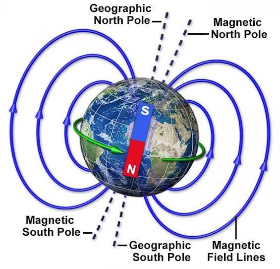
INSTA PT 2021 EXCLUSIVE PART-2 (GEOGRAPHY AND PLACES IN NEWS)

                                                                                                          NOTES
    Important Geophysical phenomena and geographical features
1. Summer solstice
June 21- this day is referred to as the summer solstice, the longest day of the summer season. It
occurs when the sun is directly over the Tropic of Cancer.

What causes this?
Solstice means “sun stands still” in Latin.
Solstice is an astronomical event, caused by Earth’s
tilt on its axis and its motion in orbit around the
sun.
At the June solstice, Earth is positioned in its orbit so
that our world’s North Pole is leaning most toward
the sun.
● As seen from Earth, the sun is directly overhead
     at noon 23 1/2 degrees north of the equator, at
     an imaginary line encircling the globe known as
     the Tropic of Cancer – named after the
     constellation Cancer the Crab. This is as far north
     as the sun ever gets.

Implications:
1. All locations north of the equator have days longer than 12 hours at the June solstice.
   Meanwhile, all locations south of the equator have days shorter than 12 hours.
2. This day is characterised by a greater amount of energy received from the sun. According to
   NASA, the amount of incoming energy the Earth received from the sun on this day is 30 per
   cent higher at the North Pole than at the Equator.

What is the winter solstice?
21st December or the Winter Solstice marks the shortest day of the year in the Northern
Hemisphere.
    ● It is the shortest day and longest night of the year in the Northern Hemisphere and is also
        known as the ‘first day of winter’ in the Northern Hemisphere as well as ‘Hiemal solstice
        or Hibernal solstice’.
    ● During this, countries in the Northern Hemisphere are farthest from the Sun and the Sun
        shines overhead on the Tropic of Capricorn (23.5° south).

2. Anti-hail guns
To help out horticulturists who face crop damage due to hailstorms, the Himachal Pradesh
government tested the use of indigenously developed ‘anti-hail guns’.

What is hail?
Hail is produced by cumulonimbus clouds, which are generally
large and dark and may cause thunder and lightning.
    ● In such clouds, winds can blow up the water droplets to
         heights where they freeze into ice. The frozen droplets
         begin to fall but are soon pushed back up by the winds
         and more droplets freeze onto them, resulting in
         multiple layers of ice on the hailstones.
    ● This fall and rise is repeated several times, till the
         hailstones become too heavy and fall down.

www.insightsonindia.com                                     2                                       InsightsIAS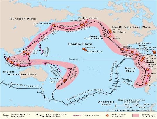
INSTA PT 2021 EXCLUSIVE PART-2 (GEOGRAPHY AND PLACES IN NEWS)

                                                                                                             NOTES
What are 'anti-hail guns'?
  ● An anti-hail gun is a machine which generates shock waves
       to disrupt the growth of hailstones in clouds.
  ● It comprises a tall, fixed structure somewhat resembling an
       invert ed tower, several metres high, with a long and narrow
       cone opening towards the sky.
  ● The gun is “fired” by feeding an explosive mixture of
       acetylene gas and air into its lower chamber, which releases
       a shock wave (waves which travel faster than the speed of
       sound, such as those produced by supersonic aircraft).
  ● These shock waves supposedly stop water droplets in
       clouds from turning into hailstones, so that they fall simply as raindrops.

But, what is the need? Why is hail a big issue in HP?
Every summer from March to May, frequent hailstorms in the fruit-growing areas of Himachal
destroy apples, pears and other crops, causing massive losses to farmers. In some hail-prone
areas such as Narkanda and Theog, the entire apple crop in an orchard may sometimes get
destroyed during such storms.

3. Climate change causing a shift in Earth’s axis
According to a study, due to the significant melting of glaciers because of global temperature rise,
our planet’s axis of rotation has been moving more than usual since the 1990s.

Implications:
While this change is not expected to affect daily life, it can change the length of the day by a few
milliseconds.

What is the Earth’s axis?
The Earth’s axis of rotation is the line along which
it spins around itself as it revolves around the Sun.
The points on which the axis intersects the planet’s
surface are the geographical north and south
poles.

How it shifts?
The location of the poles is not fixed, however, as
the axis moves due to changes in how the Earth’s
mass is distributed around the planet. Thus, the
poles move when the axis moves, and the
movement is called “polar motion”.
● According to NASA, data from the 20th century shows that the spin axis drifted about 10
    centimetres per year. Meaning over a century, polar motion exceeds 10 metres.
● Generally, polar motion is caused by changes in the hydrosphere, atmosphere, oceans, or
    solid Earth.

What the new study says?
● Since the 1990s, climate change has caused billions of tonnes of glacial ice to melt into
  oceans. This has caused the Earth’s poles to move in new directions.
● As per the study, the north pole has shifted in a new eastward direction since the 1990s,
  because of changes in the hydrosphere (meaning the way in which water is stored on Earth).
● From 1995 to 2020, the average speed of drift was 17 times faster than from 1981 to 1995.
  Also, in the last four decades, the poles moved by about 4 metres in distance.

www.insightsonindia.com                                     3                                          InsightsIAS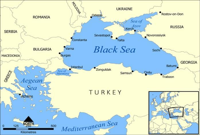
INSTA PT 2021 EXCLUSIVE PART-2 (GEOGRAPHY AND PLACES IN NEWS)

                                                                                                             NOTES
Latest factors behind this change:
● The faster ice melting, change in non‐glacial regions due to climate change and unsustainable
    consumption of groundwater for irrigation and other anthropogenic activities.
● As millions of tonnes of water from below the land is pumped out every year for drinking,
    industries or agriculture, most of it eventually joins the sea, thus redistributing the planet’s
    mass.

4. Lineament
A lineament is a linear feature in a landscape dictated by an underlying geological structure such
as a fault.

Context:
According to a recent study, an unfamiliar lineament is one factor behind frequent earthquakes in
northern Assam’s Sonitpur area.

Why there are frequent earthquakes in Assam?
According to the Geological Survey of India (GSI), Sonitpur district lies within a tectonically
complex triangular area bounded by the east-west trending Atherkhet Fault, the northwest-
southeast trending Kopili Fault and a north-south trending lineament.

Why North east is vulnerable?
1. The Siang Fracture, Yemla Fault, Namula Thrust and Canyon Thrust are spread across the
   northeast and are active along with Main Himalayan Thrust, Main Boundary Thrust, Main
   Central Thrust and several subsidiary faults.
2. The northeast is demarcated as Seismic Zone V, which indicates a zone with high
   vulnerability.
3. The Indian plate is moving northeast toward the Eurasian plate in the Himalayan region, their
   oblique collision and release of stress and strain accumulated in the local tectonic or fault
   environments lead to earthquakes.

5. Himalayan Frontal Thrust (HFT)
•   Himalayan Frontal Thrust (HFT) also known as the Main Frontal Thrust (MFT), is a geological
    fault along the boundary of the Indian and Eurasian tectonic plates.
•   The Kopili Fault is a 300-km northwest-southeast trending fault from the Bhutan Himalaya to
    the Burmese arc.

www.insightsonindia.com                                    4                                           InsightsIAS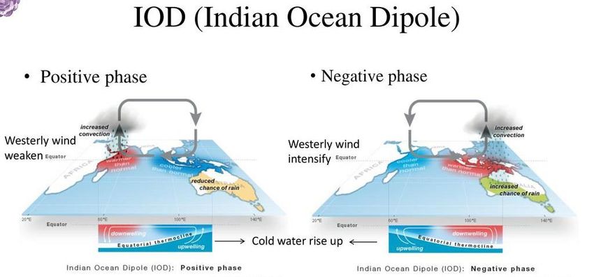
INSTA PT 2021 EXCLUSIVE PART-2 (GEOGRAPHY AND PLACES IN NEWS)

                                                                                                             NOTES
•   A fault is “a fracture along which the blocks of crust on either side have moved relative to one
    another parallel to the fracture”. When an earthquake occurs on one of these faults, the rock
    on one side of the fault slips with respect to the other. The fault surface can be vertical,
    horizontal, or at some angle to the surface of the earth.
•   The Northeast is located in the highest seismological zone.
•   The collision zone between India and Eurasia along the tremendous Himalayan mountain
    range has one of the highest seismic hazards in the world.

6. Venus
Scientists have obtained new data about Venus by bouncing radio waves off Venus.
● The researchers transmitted radio waves toward Venus 21 times from 2006 to 2020 from
    NASA's Goldstone Antenna in the Mojave Desert of California and studied the radio echo,
    which provided information on certain planetary traits.

Latest findings:
1. The study measured the tilt of the Venusian axis and size of the planet's core.
2. A single Venusian rotation takes 243.0226 Earth days. That means a day lasts longer than a
    year on Venus, which makes a complete orbit around the sun in 225 Earth days.
3. The Venusian planetary core has a diameter of about 4,360 miles (7,000 km), comparable to
    Earth's core.
4. The study calculated the Venusian tilt at about 2.64 degrees. Earth's is about 23.5 degrees.

About Venus:
● Venus, the second planet from the sun, is similar in structure but slightly smaller than Earth.
● It is called the Earth’s twin because of their similar sizes.
● Above its foreboding landscape is a thick and toxic atmosphere that consists primarily of
   carbon dioxide, with clouds of sulfuric acid droplets.
● With a runaway greenhouse effect, its surface temperatures reach 880 degrees Fahrenheit
   (471 degrees Celsius), hot enough to melt lead.
● Venus is one of just two planets that rotate from east to west. Only Venus and Uranus have
   this "backwards" rotation.
● In another quirk, its day-night cycle - the time between sunrises as opposed to the length of a
   single axial spin - takes 117 Earth days because Venus rotates in the direction opposite of its
   orbital path around the sun.
● For those on Earth, Venus is the second-brightest object in the sky after the moon. It appears
   bright because of its thick cloud cover that reflects and scatters light.
● The planet’s thick atmosphere traps heat and is the reason that it is the hottest planet in the
   solar system, despite coming after Mercury, the closest planet to the Sun. Surface
   temperatures on Venus can go up to 471 degrees Celsius, which is hot enough to melt lead,
   NASA notes.
● Venus also does not have a moon and no rings.

7. Naming of Cyclones
The World Meteorological Organisation (WMO) maintains rotating lists of names.
The word Tauktae has been suggested by Myanmar, which means 'gecko', a distinctively vocal
lizard, in the Burmese language.
● The name is the fourth from a new list of 169 names released by the IMD last year.

How are cyclones named?
● A WMO/ESCAP (World Meteorological Organisation/United Nations Economic and Social
   Commission for Asia and the Pacific) Panel on Tropical Cyclones agreed in principle to assign
   names to the tropical cyclones in the Bay of Bengal and the Arabian Sea during its 27th
   session held in Muscat, Sultanate of Oman, in 2000.

www.insightsonindia.com                                    5                                           InsightsIAS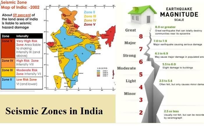
INSTA PT 2021 EXCLUSIVE PART-2 (GEOGRAPHY AND PLACES IN NEWS)

                                                                                                              NOTES
●  The naming of the tropical cyclones over the north Indian Ocean commenced from September
   2004, with names provided by eight members, starting with Bangladesh, followed by India.
   Since then, another five countries have joined the Panel.
● The Regional Specialised Meteorological Centre (RSMC), New Delhi is responsible for naming
   the cyclonic storms formed over the Bay of Bengal and the Arabian Sea when they reach the
   relevant intensity.
There are six RSMCs in the world, including the IMD and five Tropical Cyclone Warning Centres.

How are cyclones formed?
Cyclones are formed over the oceanic water in the tropical region.
In this region, the sunlight is highest which results in warming of land and water surface. Due to
warming of the surface, the warm moist air over the ocean rises upwards following which cool air
rushes in to fill the void, they too get warm and rise — the cycle continues.

But what creates the spin?
Wind always blows from high pressure to low pressure areas. High pressure areas are created in
the cold region while low is created in the warm regions. Polar regions are high pressure areas as
the amount of sunlight here is less than the tropical region. So, wind blows from polar regions to
tropical regions.
● Then comes the Earth's movement, which is west to east. The Earth's rotation on its axis
    causes deflection of the wind (in the tropical region as the speed of spinning of Earth is higher
    compared to polar sides due to its spherical shape — blowing from both the polar regions.
    Wind coming from the Arctic is deflected to the right while Antarctic wind deflects to the left
    side.
● So, wind is already blowing in a direction. But when it reaches the warmer place, cool air
    starts getting attracted to the centre to fill the gap. So while moving to the centre, cool air
    keeps getting deflected resulting in circulation of wind movement — this process continues
    until the cyclone hits the land.

What happens when a cyclone hits the land?
Cyclone dissipates when it hits the land as the warm water that rises and creates space for cool
water is no longer available on land. Also, the moist air that rises up forms clouds leading to rains
that accompany gusting winds during cyclones.

Unlike most cyclones that are forced to weaken post landfall as they detach from the sea,
Tauktae retained its intensity as a cyclone and maintained wind speeds between 60 and 70
km/hr gusting to 80 km/hr.
Cyclones are formed between the tropics while western disturbances are formed in the mid-
latitudes. When the two interact, they influence each other. Such an interaction occurred at the
time of landfall on the evening of May 17.

As Cyclone Tauktae came under the influence of western disturbances, it slowed down as it was
crossing over to land. This slow progress over the coast ensured that the cyclone continued to get
sufficient moisture supply from the sea. Hence it did not weaken, but rather retained its intensity
even 24 hours after coming over land.

8. Bay of Bengal hotter than normal
Climate scientists say the Bay of Bengal is at least two degrees warmer than what is normal for
this time of the year.

Background:
Generally, cyclones in the Bay of Bengal are ferocious and cause significant devastation. This year,
the north Bay of Bengal is exceptionally warm with temperatures up to 32 degrees Celsius.

www.insightsonindia.com                                     6                                           InsightsIAS
INSTA PT 2021 EXCLUSIVE PART-2 (GEOGRAPHY AND PLACES IN NEWS)

                                                                                                           NOTES
Recent cyclones in Bay of Bengal:
● Amphan was a super cyclone that ravaged West Bengal in May 2020. It was the strongest
   storm that hit India’s eastern coast since the super cyclone of 1999, that struck Paradip,
   Odisha.
● Before Amphan, Fani in 2019 also hit Odisha, causing immense damage that lasted weeks.

What's the concern?
In the last four years 12 cyclones have
formed in the Bay. Out of five cyclones that
the Indian coastline witnessed in a year, four
originated in the Bay of Bengal and only one
in the Arabian Sea.
● There is also increasing frequency of
     cyclone formation in the North Indian
     Ocean in recent years.

Why Bay of Bengal is the hot-bed for
cyclonic storms?
1. The vast low pressure created by the
    warm water of the ocean.
2. The Bay of Bengal shaped like a trough
    that makes it more hospitable for storms
    to gain force.
3. The high sea surface temperature
    makes matters more worse in the Bay
    triggering the intensity of the storms.
4. The Bay of Bengal also gets more rainfall with sluggish winds and warm air currents around
    it that keep temperatures relatively high all year.
5. The constant inflow of fresh warm water from the perineal rivers like Bramhaputra, Ganga
    makes it further impossible to mix with the cooler water below.
6. Lack of landmass between the Pacific Ocean and the Bay of Bengal tend cyclonic winds to
    move into the coastal areas causing heavy rainfall.
7. The absence of air movements from north-western India towards the Bay in the post-
    monsoon phase is also another reason for the chances of cyclones in the Bay of Bengal.

What geographical advantage the Arabian sea has?
● It is much calm as the stronger winds help dissipate the heat.
● Lack of constant fresh water helps the warm water to mix with the cool water underneath,
  reducing the surface temperature.
● The Arabian Sea enjoys the locational advantage as the winds from the Pacific Ocean
  encounter the Western Ghats and the Himalayas cutting down on its intensity and sometimes
  never reaching the Arabian Sea.

9. Monsoon
Criteria — as defined by the IMD to confirm the arrival of monsoon over Kerala.
The criteria are:
1. Rain-bearing westerlies being at a minimum depth and speed.
2. At least 60% of the available 14 stations in Kerala and coastal Karnataka reporting rainfall of
    2.5 mm or more for two consecutive days after May 10.
3. A certain degree of clouding, indicated by a parameter called ‘outgoing longwave radiation’
    (OLR), being below 200 W/square metre.

www.insightsonindia.com                                    7                                         InsightsIAS
INSTA PT 2021 EXCLUSIVE PART-2 (GEOGRAPHY AND PLACES IN NEWS)

                                                                                                              NOTES
Factors influencing the onset on Southwest Monsoon:
The onset of Southwest Monsoon is an emotional event as it may cause anxiety if delayed or
shoot excitement for stepping in early.
Various factors influencing it's onset:
The onset needs a trigger in the form of a weather system in the proximity of the coastline.
These are ocean born phenomena which accentuate the monsoon surge around the normal time
of onset. These include:
1. The low-pressure area or depression in the
    Bay of Bengal during the last days of May or
    the beginning of June.
2. There are such systems in the Arabian Sea as
    well around the same time which results in
    onset over the mainland.
3. ‘Cyclonic Vortex’ is another factor which
    appears in the Southeast Arabian Sea, off
    Kerala and Lakshadweep region. They also
    shift along the west coast to push the
    monsoon current.
4. The formation of ‘trough’ off the west coast
    due to temperature differential between
    land and sea. This situation could be for a
    mild start and weak progress.
5. Lastly the cross-equatorial flow, wherein the trade winds from the Southern Hemisphere
    crossover to the Northern Hemisphere can bring a strong monsoon surge towards the Indian
    mainland.

Monsoon in India- related key facts:
1. Generally, across the world, the monsoons are experienced in the tropical area roughly
   between 20° N and 20° S.
2. Out of a total of 4 seasonal divisions of India, monsoon occupy 2 divisions, namely- the
   southwest monsoon season and the retreating monsoon season.

10. Sun's halo
A mesmerising phenomenan -- a rainbow around the Sun know as a Sun halo, was observed
recently in Bengaluru.

What is it? How is it formed?
The halo that appeared around the Sun is a 22-degree
ring that appears due to the dispersion of light as
white light passes through ice crystals found in
upper-level cirrus clouds, causing the halo to have
colours.
● The clouds contain millions of tiny ice crystals,
    which refract, split and even reflect the light to give an impression of a circular rainbow ring.
● The crystals have to be oriented and positioned just so with respect to your eye, in order for
    the halo to appear.

Similarly, what are lunar halos?
Seen around the Moon, lunar halos are mostly colourless as moonlight is not very bright.

11. Total lunar eclipse and supermoon
Two celestial events- the Supermoon and a total lunar eclipse- was observed recently.

www.insightsonindia.com                                      8                                          InsightsIAS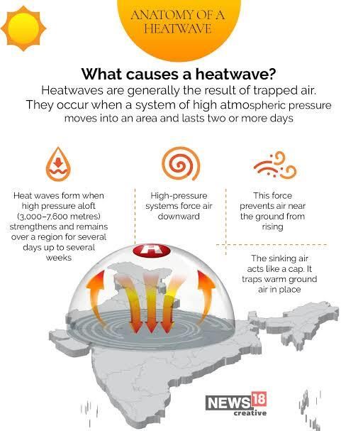
INSTA PT 2021 EXCLUSIVE PART-2 (GEOGRAPHY AND PLACES IN NEWS)

                                                                                                            NOTES
●   Significantly, a supermoon and a total lunar eclipse have not occurred together in nearly six
    years.

What is a supermoon?
A supermoon occurs when the Moon’s orbit
is closest to the Earth at the same time that
the Moon is full. In a typical year, there may
be two to four full supermoons and two to
four new supermoons in a row.
● Please note: As the Moon orbits the
     Earth, there is a point of time when the
     distance between the two is the least
     (called the perigee when the average
     distance is about 360,000 km from the Earth) and a point of time when the distance is the
     most (called the apogee when the distance is about 405,000 km from the Earth).

Why does the moon appear to be red during the event?
Because of the total lunar eclipse, the moon will also appear to be red. This is because the Earth
will block some of the light from the Sun from reaching the moon and as the Earth’s atmosphere
filters the light, it will soften “the edge of our planet’s shadow” “giving the Moon a deep, rosy
glow.”

12. Heat waves
The India Meteorological Department (IMD) says heatwave is considered when the maximum
temperature of a station touches at least 40 degrees Celsius or more for plains, 37 degrees Celsius
or more for coastal regions and at least 30 degrees Celsius or more for hilly regions.

What are the criteria?
Heatwave is declared when the departure from normal temperature is by 4.5 to 6.4 degrees
Celsius and a severe heatwave is when the departure from normal is more than 6.4 degrees
Celsius.
● For plains, based on actuals
    maximum temperature, IMD
    considers heatwave when actual
    maximum temperature is more
    than 45 degrees Celsius and
    severe heatwave when it is more
    than 47 degrees Celsius.

Reasons why India is experiencing
more heat waves are:
1. Magnified effect of paved and
   concrete surfaces in urban areas
   and a lack of tree cover.
2. Urban heat island effects can
   make ambient temperatures feel
   3 to 4 degrees more than what
   they are.
3. More heat waves were expected
   as globally temperatures had
   risen by an average 0.8 degrees
   in the past 100 years. Night-time
   temperatures are rising too.

www.insightsonindia.com                                   9                                           InsightsIAS
INSTA PT 2021 EXCLUSIVE PART-2 (GEOGRAPHY AND PLACES IN NEWS)
NOTES
4. Higher daily peak temperatures and longer, more intense heat waves are becomingly
increasingly frequent globally due to climate change.
5. High intensity of UV rays in medium-high heat wave zone.
6. Combination of exceptional heat stress and a predominantly rural population makes India
vulnerable to heat waves.
13. Indian Ocean Dipole
It is an atmosphere-ocean coupled phenomenon in the tropical Indian Ocean (like the El Nino is in
the tropical Pacific), characterised by a difference in sea-surface temperatures.
Key features:
● IOD is the difference between the temperature of eastern (Bay of Bengal) and the western
Indian Ocean (Arabian Sea).
● This temperature difference results into pressure difference which results in flowing of winds
between eastern and western parts of Indian Ocean.
● A ‘positive IOD’ — or simply ‘IOD’ — is associated with cooler than normal sea-surface
temperatures in the eastern equatorial Indian Ocean and warmer than normal sea-surface
temperatures in the western tropical Indian Ocean.
● The opposite phenomenon is called a ‘negative IOD’, and is characterised by warmer than
normal SSTs in the eastern equatorial Indian Ocean and cooler than normal SSTs in the
western tropical Indian Ocean.
Impacts:
● Studies have shown that a positive IOD year sees more than normal rainfall over central India.
● A negative IOD complements El NiNo leading to severe drought.
● At the same time, Positive IOD results in more cyclones than usual in Arabian Sea.
● Negative IOD results in stronger than usual cyclogenesis (Formation of Tropical Cyclones) in
Bay of Bengal. Cyclogenesis in Arabian Sea is suppressed during this time.
www.insightsonindia.com 10 InsightsIASINSTA PT 2021 EXCLUSIVE PART-2 (GEOGRAPHY AND PLACES IN NEWS)
NOTES
Places in News
1. Galwan river valley
There was a minor face-off between Indian and Chinese
troops in the no-patrolling zone at Galwan Valley in
eastern Ladakh in the first week of May 2021.
Background:
A no-patrolling zone extending to around 3 km, around 1.5
km each on either side of the clash site near the Y-junction
of the Galwan Valley, was created after June 15, 2020,
when 20 Indian Army personnel were killed in clashes with
Chinese troops. A 30-day moratorium was also applied on
foot-patrolling then. It was not known if it had been
extended.
Where is Galwan Valley?
• The valley refers to the land that sits between steep mountains that buffet the Galwan River.
• The river has its source in Aksai Chin, on China’s side of the LAC, and it flows from the east to
Ladakh, where it meets the Shyok river on India’s side of the LAC.
• The valley is strategically located between Ladakh in the west and Aksai Chin in the east
(currently controlled by China).
• At its western end are the Shyok river and the Darbuk-Shyok-Daulet Beg Oldie (DSDBO) road.
2. Gulf Of Aden
Maiden Indian Navy - European Union Naval
Force (EUNAVFOR) Exercise was held in Gulf
Of Aden.
● Gulf of Aden, also known as the Gulf of
Berbera, is a deepwater gulf between
Yemen to the north, the Arabian Sea to
the east, Djibouti to the west, and the
Guardafui Channel, Socotra (Yemen), and
Somalia to the south.
● In the northwest, it connects with the Red
Sea through the Bab-el-Mandeb strait,
and it connects with the Arabian Sea to
the east. To the west, it narrows into the Gulf of Tadjoura in Djibouti.
3. Black Sea
● Black Sea is an inland sea located
between far-southeastern Europe and the
far-western edges of the continent of Asia
and the country of Turkey.
● Bordering Countries: Romania, Bulgaria,
Ukraine, Russia, Georgia, and Turkey.
● It connects to the Mediterranean Sea first
through the Bosporus Strait, then
through the Sea of Marmara and the
Dardanelles Strait, then south through
the Aegean Sea and the Sea of Crete.
● The Black Sea is also connected to the Sea of Azov by the Strait of Kerch.
www.insightsonindia.com 11 InsightsIASINSTA PT 2021 EXCLUSIVE PART-2 (GEOGRAPHY AND PLACES IN NEWS)
NOTES
4. China launches first bullet train in Tibet, close to Indian border
● China has operationalised its first fully
electrified bullet train in the remote
Himalayan region of Tibet.
● It connects the provincial capital Lhasa
and Nyingchi, a strategically located
Tibetan border town close to Arunachal
Pradesh.
● This line is a section of the Sichuan-Tibet
Railway.
● The rail line crosses the Brahmaputra
river locally called Yarlung Zangbo 16 times.
5. Atlas of glacial lakes
● Ministry of Jal Shakti has released an
updated atlas of glacial lakes that are part
of the Ganga river basin.
● About 4,707 glacial lakes have been mapped
in the Ganga basin.
● Glacial lakes with water spread area greater
than 0.25 ha were mapped using
Resourcesat-2 Linear Imaging Self Scanning
Sensor-IV satellite data.
● The Atlas is available on Bhuvan portal of
National Remote Sensing Centre (NRSC), ISRO.
● The expected “utility” of the atlas:
○ create a “comprehensive and systematic” glacial lake database for Ganga River
basin.
○ Could be used as reference for carrying out changes in the lakes over time, the
spatial extent (expansion/shrinkage), and formation of new lakes.
○ The information on glacial lakes including their type, hydrological, topographical, and
associated glaciers are useful in identifying the potential critical glacial lakes and
consequent GLOF (Glacial Lake Outburst Flood) events. These refer to disasters
whereby a deluge of water from such a lake can trigger a disaster.
○ The Chamoli disaster this year was initially thought to be a GLOF event but later,
scientists have concluded that it was caused by the breaking off of a mass of rock and
ice.
6. Vorukh
● It is a jamoat in northern Tajikistan. It is
an exclave surrounded by Kyrgyzstan that
forms part of the city of Isfara in Sughd
Region.
● Jamoats are the third-level administrative
divisions, similar to communes or
municipalities, in the Central Asian
country of Tajikistan.
Why in News?
Kyrgyzstan and Tajikistan border tension.
www.insightsonindia.com 12 InsightsIASINSTA PT 2021 EXCLUSIVE PART-2 (GEOGRAPHY AND PLACES IN NEWS)
NOTES
7. Kachin people
● They are a confederation of ethnic groups who inhabit the
Kachin Hills in northern Myanmar's Kachin State and
neighbouring Yunnan Province, China, and Arunachal
Pradesh, Assam in Northeastern India.
● The term Kachin people is often used interchangeably with
the main subset, called the Jingpo people in China.
Why in News?
Protests against Myanmar’s military government continued in
Kachin State and elsewhere in the country.
8. Dahla Dam
● It is Afghanistan’s second-biggest dam.
● The Taliban has captured it after months of
fierce fighting.
● It is located in Kandahar Province in
Afghanistan.
● The Dahla Dam is built on the Arghandab
River.
9. Mount Sinabung
Located in Indonesia. The volcano
has been active since 2010 when it
erupted after nearly 400 years of
inactivity.
Why in News?
Because of the recent eruption.
Background:
Indonesia is home to many active
volcanoes owing to its location in the “Ring of Fire” or the Circum-Pacific Belt — an area along the
Pacific Ocean characterised by active volcanoes and frequent earthquakes.
10. Badrinath Dham
Five oil PSUs have pledged Rs 100 crore for development of Badrinath Dham in Uttarakhand as a
spiritual smart city.
● The developmental activities will include river embankment work, building all-terrain
vehicular path, building bridges, beautifying existing bridges, establishing gurukul facilities
with accommodation etc.
● The expenditure will be borne by the companies from their CSR fund.
Geography:
Badrinath is in the Garhwal Himalayas, on the banks of the Alaknanda River. The town lies
between the Nar and Narayana mountain ranges 9 km east of Nilkantha peak (6,596m).
Badrinath is located 62 km northwest of Nanda Devi peak and 301 km north of Rishikesh.
www.insightsonindia.com 13 InsightsIASINSTA PT 2021 EXCLUSIVE PART-2 (GEOGRAPHY AND PLACES IN NEWS)
NOTES
11. Belarus
• It is a landlocked country in Eastern Europe.
• It is bordered by Russia to the east and
northeast, Ukraine to the south, Poland to
the west, and Lithuania and Latvia to the
northwest.
12. Cali
● Cali is the second-largest city in Colombia by area and the
third most populous.
● It is the only major Colombian city with access to the Pacific
Coast.
● Cali is located in the Cauca Valley to the west of the Cauca
River.
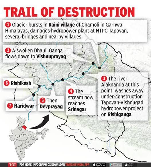
13. Rishiganga
● It is a river in the Chamoli district, Uttarakhand,
India.
● Sources: It springs from the Uttari Nanda Devi
Glacier on the Nanda Devi mountain. It is also
fed from the Dakshini Nanda Devi Glacier.
● Continuing through the Nanda Devi National
Park, it flows into the Dhauliganga River near
the village Rini.
Disaster in 2021:
In February 2021, a flooding disaster occurred all
along the river and its gorge following a landslide,
avalanche or glacial lake outburst flood.
14. Red sea
• The Red Sea (also the Erythraean Sea) is a seawater inlet of
the Indian Ocean, lying between Africa and Asia.
• The connection to the ocean is in the south through the
Bab el Mandeb strait and the Gulf of Aden.
• To the north lie the Sinai Peninsula, the Gulf of Aqaba,
and the Gulf of Suez (leading to the Suez Canal).
• The sea is underlain by the Red Sea Rift which is part of
the Great Rift Valley.
The salinity of the Red Sea is greater than the world average, approximately 4 percent. This is due
to several factors:
1. Lack of significant rivers or streams draining into the sea.
2. Limited connection with the Indian Ocean, which has lower water salinity.
3. High rate of evaporation and very little precipitation.
15. Cholistan desert
● Located in Pakistan.
● The place was in news because of recent shooting of two Great Indian Bustards (GIBs) here.
www.insightsonindia.com 14 InsightsIASINSTA PT 2021 EXCLUSIVE PART-2 (GEOGRAPHY AND PLACES IN NEWS)
NOTES
About Great Indian Bustards is already covered in previous Environment module.
16. Sahel
● Chad, the former French colony is now prime outpost of the
West in fighting Islmamist militants across the Sahel. France
still has a strong military presence in the sahel region.
● The Sahel is the ecoclimatic and biogeographic realm of
transition in Africa between the Sahara to the north and the
Sudanian savanna to the south.
● Having a semi-arid climate, it stretches across the south-
central latitudes of Northern Africa between the Atlantic
Ocean and the Red Sea.
● The Sahel part of Africa includes northern Senegal, southern Mauritania, central Mali,
northern Burkina Faso, the extreme south of Algeria, Niger, the extreme north of Nigeria, the
extreme north of Cameroon and Central African Republic, central Chad, central and southern
Sudan, the extreme north of South Sudan, Eritrea, and the extreme north of Ethiopia.
17. Doomsday Glacier
● Also called the Thwaites Glacier, it is located in
Antarctica.
● The melting of this glacier has long been a cause of
concern because of its high potential of speeding up the
global sea level rise happening due to climate change.
● It is 120 km wide at its broadest. Because of its size (1.9
lakh square km), it contains enough water to raise the
world sea level by more than half a metre.
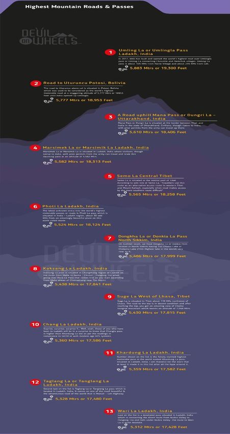
18. Umling La
● At 5,793m (19,005ft) above the sea level, Umling La is one of the highest motorable roads in
the world.
● Located in the Ladakh region.
● The 54 km long road passing through Umling La Pass connected the villages of Chisumle and
Demchok and took six years to be built by BRO under Project Himank.
www.insightsonindia.com 15 InsightsIASINSTA PT 2021 EXCLUSIVE PART-2 (GEOGRAPHY AND PLACES IN NEWS)
NOTES
www.insightsonindia.com 16 InsightsIASYou can also read