GUIDE 2022 - WINK's New Doppler: SWFL's Biggest Weather Weapon Ever - THE WEATHER AUTHORITY - cdn.winknews.com
←
→
Page content transcription
If your browser does not render page correctly, please read the page content below
T H E W E AT H E R AU T H O R I T Y

     HURRICANE
             GUIDE 2022

                  First Forecast for the Season
WINK’s New Doppler: SWFL’s Biggest Weather Weapon … Ever
               Tornadoes Strike: WINK Saved Lives
                   Prepare NOW: Here’s How
                    Finding Safety in a Storm
HURRICANE CLEAN UP -
Separating Your Debris
Debris should be placed curbside, without blocking the roadway or storm drains.
KUP
NO PIC
ZONE
ris
Any deb m
fro
placed
walk
the side ur
y o
toward
y will
propert
not be .
p
picked u
HOUSEHOLD
HAZARDOUS
ELECTRONICS WASTE
Computers Check with your
APPLIANCES &
Radios local government.
WHITE GOODS
CONSTRUCTION & Stereos
Air conditioners
DEMOLITION DEBRIS Televisions
Dishwashers
VEGETATIVE DEBRIS Building materials Other devices with
Freezers a cord
Logs Carpet Refrigerators
Normal Household Plants Drywall Stoves
Trash Tree branches Furniture
Normal household Washers, dryers
Leaves (do not put in Lumber Water heaters
trash and bagged Mattresses
debris of any kind will bags) * If you have a lot
of leaves and small twigs Plumbing
not be picked up with
disaster debris. You in plastic bags, please
should continue to set those aside from
follow your normal any brush piles.
garbage removal
schedule.
* The brush will be ground into mulch, so plastic must be avoided.
DEBRIS SEPARATION DO NOT STACK OR LEAN UNSURE WHERE TO PLACE DEBRIS?
Separate debris into the Placing debris near or on trees, If you don’t have a sidewalk, ditch, or
six categories shown. poles, or other structures makes utility line in front of your house,
removal difficult. This includes place debris at the edge of your property
fire hydrants and meters. before the curb.
FREQUENTLY ASKED QUESTIONS ABOUT HURRICANE CLEAN UP
What is the difference between storm-related debris and regular household trash?
Storm debris includes any trees, tree limbs and shrubs that went down in the hurricane. Regular household trash is what
you would throw away in a typical week.
When will the storm debris be collected from my curb and what should I do to prepare?
There is no schedule for when storm debris will be collected from your neighborhood, but be assured that it will. Cleanup efforts take time.
When will my regular household collections resume?
Regular collections of garbage, recycling and your normal weekly yard waste resume as soon as it is safe for collection crews to do so.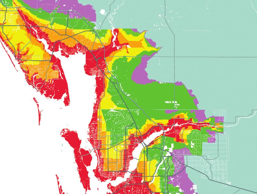
www.charlottecountyfl.gov                  www.colliercountyfl.gov                www.leegov.com/solidwaste
      941-764-4360                             239-252-2380                              239-533-8000

Prepare your property for storm season before June 1
§ Cut back any trees or branches that contact your house, pool cage, shed or other buildings.
§ Thin foliage so wind can blow freely through branches, decreasing chances the plant will become uprooted
  during a storm.
§ Place trimmings at the curb on your regular collection day. Yard waste must be containerized in an extra yard
  waste container, paper lawn, leaf bag, or bundled. Yard waste in plastic bags will not be collected.
  § Charlotte County – Cans and bundles cannot weigh more than 40 lbs. each. Limbs cannot be more than 6
    feet in length or 10 inches in diameter.
  § Collier County – Cans and bundles cannot weigh more than 50 lbs. each. Limbs cannot be more than 4 feet in
    length of 4 inches in diameter. A total of ten 45-gallon containers or ten bundles of yard waste may be placed
    curbside.
  § Lee County – Cans and bundles cannot weigh more than 50 lbs. each. Limbs cannot be more than 6 feet in
    length. Up to 50 lbs. of unbundled palm fronds may be placed at the curb.
§ Clean your property of any items that could become a projectile during a storm, such as old lumber, broken lawn
  furniture, etc., and place them at the curb on your regular waste collection day.

Once a storm has been named or a hurricane watch / warning has been issued:
§ Do not cut down trees and do not do any major yard work. Mass cutting produces a burden on the normal
  collection process.
§ Do not begin construction projects that produce debris unless absolutely necessary to protect life and property.
§ Secure all debris and do not place materials of any kind at the curb during a Watch or Warning period.
§ Services may be suspended and facilities closed early to prepare for the storm. For information on the status of
  collection services and disposal facilities, residents should monitor local media or check the county government
  websites.

After the storm has passed:
§ Most important – keep storm debris separate from your regular household garbage and recycling.
§ Storm debris should be sorted into separate piles for garbage, yard waste, appliances, furniture & other bulky
  waste, appliances and construction debris as shown in the diagram to the left. Check with your local government
  regarding set out of household hazardous waste.
§ Pick up will generally be done with a mechanized claw truck so it’s important that you not set debris over
  buried electric/phone lines, water meters, hydrants or mailboxes. Inspectors will tour each part of the county to
  determine where collection needs are greatest.
§ Be patient. Following a storm, the No. 1 priority is the health and safety of our community and restoration of the
  county. When collection services resume, place garbage curbside away from storm-related debris on your regular
  collection service day.
§ Debris collection guidance and recovery process updates will be available through local media and on county
  government websites.
“A fa mil y n am e you ca n tr ust”

                       HADINGER
                            Flooring
                        Est. 1931

Has Teamed Up With

                     100% Waterproof, Kidproof, and Petproof

E xc l us i ve C ol or s Ca n ONLY B e Found Here!
We focus on those ideas every day.

                                                    FREE RUG PAD
                                                     with area rug purchase.

                                                     Over 8000
                                                 area rugs in stock.
                                                  We Listen. We Design. We Please.
                                                 Bring in your fabric swatch, paint chip or throw
                                                 pillow and let one of our design professionals
                                                 help you.

   We Are MORE Than Just A Flooring Store!

6401 North Airport-Pulling Road • Naples, FL 34109 • 239-566-7100 • hadingerflooring.com
A M E S S AG E F R O M M AT T D E V I T T
                                               WINK News Chief Meteorologist

              W
                             elcome to the 2022 WINK News Hurricane Guide.
                                As much as we would love to have beautiful Southwest Florida weather all year
                             round, hurricane season is now here. For the next six months the WINK News
                             Weather Team, The Weather Authority, will constantly monitor for tropical
              depressions, tropical storms and hurricanes that could impact Southwest Florida.
                 Last year, the 2021 Atlantic hurricane season was the third most active on record, with a
              preliminary 21 named storms, seven hurricanes and four major (measuring Category 3 and
              above) hurricanes. It was also the third costliest hurricane season on record behind 2005 and
              2017, with more than $80 billion in damages.
                 The worst storm of 2021, Category 4 Hurricane Ida, avoided Southwest Florida and devastated
              Louisiana with winds of 150 mph, tied for strongest in state history. The only impact we felt last
              year was a brush from Category 1 Hurricane Elsa on July 6. Even though it stayed 100 miles off the
              coast, the storm still brought seven to 11 inches of rain and flooding, two feet of storm surge and
              wind gusts up to 55 mph. Considering a record-breaking 51 storms and 19 U.S. landfalls over the
              last two hurricane seasons, luck has certainly been on Southwest Florida’s side.
                 The hyperactive 2020 and 2021 Atlantic hurricane seasons were both fueled by a La Niña,
              which is marked by cooler-than-average waters in the eastern Pacific and can influence weather
              patterns. It contributes to an increase in Atlantic tropical activity by weakening wind shear,
              which enables storms to develop and intensify.
HURRICANE        For the 2022 Hurricane Season, La Niña is projected to weaken as eastern Pacific waters return
GUIDE         to more neutral levels. What does that mean for us in Southwest Florida? If that occurs, it would
2022          lower the potential to see a record-breaking number of storms like in 2020 and 2021. Now before
              you get too excited, even neutral conditions can still lead to an active, above-normal season in the
              Atlantic.
                 Regardless of the number of storms, all it takes is ONE devastating hurricane across Florida
              to leave a lasting impact, which Category 5 Hurricane Andrew taught us in 1992 during a season
              with “only” seven storms.
                 Keep this helpful guide with you and remain vigilant during hurricane season. My best advice
              is to get ready now when the weather is quiet. Don’t wait until a hurricane is on the way to gather
              supplies and develop a plan for your family if told to evacuate.
                 I’ll be here every step of the way calmly guiding you through any future storms that may come
              our way, just like in 2017 with Hurricane Irma. Trust WINK, The Weather Authority, to deliver
              accurate information 24/7 all season long.
                                                                                                                     Brian Tietz

                 And let’s have a safe 2022!

4    HURRICANE GUIDE 2022
In-Store and Online at CityMattress.com
58of
Years Sleep
EXPERTISE
Value, Selection, Quality and Service
all at the Guaranteed Lowest Prices
Free Local Delivery and Set‑up
Interest‑Free Financing
90‑Night Comfort Guarantee
NAPLES | NORTH NAPLES | ESTERO | FORT MYERS
HOURS Saturday 9 am - 6 pm • Sunday 11 am - 5 pm • Monday-Friday 9 am - 8 pm
14
                            Wind and water
                            Storm surges, tornadoes
                            and other hazards. Also     22
                            includes Learn these        Prepare now for the
                            terms to stay safe.         2022 hurricane season
HURRICANE
                                                        FEMA Administrator
GUIDE
2022
                            16                          Deanne Criswell
                            The Saffir-Simpson          examines must-do prep
                            hurricane scale             for the seaon.
                            How to rate a storm’s
                            intensity.                  24
                                                        Our coverage saved lives
                            17                          When deadly tornadoes
                            Hurricane tracking map      hit the area on Jan. 16,
                            This pull-out map charts    meteorologists at WINK
                            the areas of the Atlantic   News, The Weather
                            where hurricanes can        Authority, sprang into
                            form—and wreak havoc.       action.

                            18                          26                          34
CON TEN T                   Southwest Florida           Keeping Floridians Safe     Preparing your family
                            evacuation zones            Florida Gov. Ron            From communication
                            This handy map can help     DeSantis writes about his   plans to supply lists,
4                           you determine which         top priority: keeping the   the key elements you’ll
A Message from Matt         zone you live in and what   citizens of the Sunshine    need to help your family
Devitt                      that means.                 State free from harm.       and friends cope with a
The chief meteorologist                                                             major storm.
for WINK News, The
Weather Authority, ushers                                                           38
in this year’s guide.                                                               Preparing your home/
                                                                                    Preparing your boat
8                                                                                   Get your home ready
Prepare now for the                                                                 for a hurricaine with
season ahead                                                                        these precautions. And,
Right now is the best                                                               boats are particularly
time to get ready for                                                               vulnerable to damage
a hurricane. The 2022                                                               during tropical storms.
WINK News Hurricane
Guide is your essential                                                             40
source for storm                                                                    Hurricane safe at home
information this season.                                                            Find out what the
                                                                                    homebuilding industry
10                                                                                  has learned about
The 2022 hurricane                                                                  hurricanes through the
outlook                                                                             years.
Hurricane researchers at
                            20                                                      42
Colorado State University
have issued their first     Know your risks             28                          Don’t wait to take
2022 Atlantic hurricane     Hurricanes can be           A highly accurate view      action, get prepared for
season forecast and         highly destructive and      of potential danger         hurricane season TODAY
they’re calling for an      potentially deadly.         Learn all about WINK’s      Rick Scott, U.S. Senator
above-normal season.        You need to treat           new dual-pol Doppler        from Florida and former
                            these storms—and the        radar, the most powerful    governor, on getting
                            dangers associated with     in Southwest Florida.       ready immediately for
                            them—very seriously.                                    any potential storms this
                                                                                    year.

6      HURRICANE GUIDE 2022
28

                            50
                            Post-hurricane safety
                            concerns
                            What to watch out for
                            during the recovery
                            period. There are still
                            some dangers out there.

44                          51
A culture of                Healthy preparation for
preparedness                hurricane season
Patrick Fuller, director    Lee Health President and
of the Charlotte County     CEO Larry Antonucci
Office of Emergency         looks at how you can stay
Management, on how          healthy no matter what
to cultivate the right      happens this season.
attitude about readiness
this season.                52
                            The storm is over
46                          Many dangers still exist
Public safety is a          after a hurricane has
partnership                 passed. During this clean-
Collier County Sheriff      up-and-repair period,
Kevin Rambosk on what       focus on keeping yourself,
it takes to make his        and those around you,
department ready to act     safe.
if a hurricane hits the
area.                       56
                            Dangers of electricity
48                          After a hurricane,
Evacuating to a shelter     electrical equipment,
When evacuation orders      downed power lines and
are issued, you should      household wiring can
heed them—even if it        pose potential hazards if
means going to a shelter.   not dealt with properly.     62
Here’s what you need        Here’s how to contend        Area phone
to know before you          with such problems.          numbers and
arrive.                                                  websites
                            58                           The numbers and sites
                            Area shelters and            you need before, during
                            refuges of last resort       and after a hurricane.
                            Your resource for
                            finding shelters around      64
                            Southwest Florida. With      Always there
                            map.                         WINK News, The
                                                         Weather Authority, stays
                                                         with you in a hurricane.

                                                                                T H E W E AT H E R A U T H O R I T Y   7
PREPARE NOW FOR THE SEASON AHEAD

            N
                       ow is the time to prepare for hurricane season. Waiting until a storm is approaching
                       Southwest Florida is far too late to get ready.
                          The hurricane season stretches from June 1 through Nov. 30, and at any point during
                       that period you should be ready to brave a major storm if one should hit. We all hope
            for a mild season, but memories of devastating storms with names like Irma, Michael, Matthew,
            Katrina, Rita, Charley and Wilma remain fresh in the minds of many Floridians. Anyone who has
            been through a hurricane can tell you that it’s an experience they don’t want to revisit. All it takes
            is just one storm to reduce homes to rubble, turn the tallest trees into timber wood and transform
            cities and towns into disaster zones.
HURRICANE
               The 2022 WINK News Hurricane Guide was written to help you avoid those kinds of calamities.
GUIDE
2022
            Put together by WINK News, The Weather Authority, this guide’s sole purpose is to help you
            prepare in advance for the season ahead. Please keep a copy of the 2022 WINK News Hurricane
            Guide on hand throughout the next several months and use it to help you plan for protecting your
            family, your home and your property. It will show you how to assess the kinds of supplies you will
            need, to devise a communication plan, to put together an evacuation strategy and to deal with the
            physical, emotional and financial aftermath of a hurricane.
               The most important things you can learn from this guide are that making comprehensive
            preparations and taking preventative measures can make all the difference when it comes to
            surviving a hurricane unscathed. By planning ahead, staying informed and remaining alert, you,
            your family and your friends will make it through another season successfully.
               The 2022 WINK News Hurricane Guide is here for you. Please use it to stay safe and sound.
                                                                                                                     Getty

8   HURRICANE GUIDE 2022
STRONGER. SAFER. MORE AFFORDABLE. EASIER TO DEPLOY.
AstroGuard Hurricane Fabric Delivered a 100% Success Rate During Hurricane Irma—a Category 4 Storm
WE ALSO PROVIDE:
MOTORIZED ROLLDOWN SHUTTERS
BAHAMA SHUTTERS
Naples Shutter offers the quickest turnaround and ACCORDIONS • METAL PANELS
most experienced installers to protect your home in time
for the 2022 hurricane season! AstroGuard Hurricane Fabric NO supply chain issues! Quick install, usually within 2-3
is the all-around smartest choice to defend against weeks. NO price inflation! Same price as 5 years ago.
wind, water and flying debris.
• Insurance approved • Rapid deployment
• Florida Building Code approved • 100% UV resistant
• Miami-Dade approved • Translucent; lets light in
• Blocks 99% of wind and rain • Lightweight
• Category 5 wind load tested • Compact for easy storage
• Protection from flying debris • 10-year limited warranty
SAVE $300
on AstroGuard Hurricane Fabric
1025 Power Street, Naples, FL 34104
239.566.8161
2016 2016 2017 www.NaplesShutter.com
Showroom Hours: 8:30am–5:00pm M–F
2010-2019 Winners info@NaplesShutter.com
Coupon must be presented at time of estimate. Coupon cannot be used in conjunction
CALL 239.566.8161 FOR A FREE IN-HOME with any other special offers. Only one coupon per household. Minimum order of 400
square feet installed by Naples Shutter. Expires 12/31/22.
ESTIMATE, OR VISIT OUR SHOWROOM TODAY!HURRICANE
GUIDE
2022
HURRICANE FORECAST 2022
THE 2022
HURRICANE OUTLOOK When the report was re-
leased in April, Caribbean and
RESEARCHERS PREDICT AN ACTIVE SEASON subtropical Atlantic sea sur-
face temperatures were warmer
than normal, which contribut-
ed to the active hurricane sea-
son prediction. Other factors
included weak La Niña condi-
tions and an unlikely chance
for a significant El Niño effect.
When El Niño is present, it cre-
ates upper-level westerly winds
across the Caribbean and into
the tropical Atlantic. These up-
per-level winds are called shear,
and they help tear hurricanes
apart.
“Too much shear is good for
us and bad for hurricanes,” says
Dr. Phil Klotzbach, a research
scientist with the department
of atmospheric science at Colo-
rado State University. “Unfor-
tunately, we don’t think El Ni-
ño will be there this year. It will
more likely be neutral condi-
tions or weak La Niña.”
He points to the warmer-
than-average temperatures in
the Caribbean and subtropi-
cal Atlantic as being a major
factor in the upcoming ac-
tive hurricane season. “These
are subtle changes,” Klotz-
bach says. “We’re talking an
increase of one degree Fahr-
enheit. In the tropics, small
H
urricane researchers at Colorado State University have issued their changes in temperature can
first 2022 Atlantic hurricane season forecast and they’re calling for an make a big difference in how
above-normal season. the atmosphere responds.”
The research team at the CSU Tropical Meteorology Project predicts there The hurricane research team
will be 19 named storms this year. Researchers forecast that nine of these at CSU anticipates a 71 percent
named storms will become hurricanes. Of the nine storms that become hurri- probability of at least one ma-
canes, the research team believes four of them will reach major hurricane sta- jor hurricane making landfall
tus. A major hurricane has sustained winds of at least 111 miles per hour and is somewhere along the coastline
Jerry Pomales
classified as either a Category 3, 4 or 5 on the Saffir-Simpson scale. The 2022 of the United States in 2022. The
Atlantic hurricane season runs from June 1 to November 30. average for the last century was
10 HURRICANE GUIDE 2022BEST PRICES 350 OFF
$
IN TOWN ANY NEW ORDER
CALL FOR DETAILS
THE SHIELD HURRICANE SCREEN
Strong & Versatile
See Through Protection from Rain, Wind, Insects & Violent Hurricanes
It’s Hurricane Season
ARE YOU PREPARED?
Windows • Doors • Shutters • Lanai Enclosures
Roll Downs • Accordions • Clear Panels • Hurricane Screens • Impact Windows & Doors
Motors 100% Warranted for 8 Years!
FREE ESTIMATES
LEE & COLLIER: 239-590-9463
LICENSED & INSURED OTHER AREAS 1-877-990-WIND (9463)
FLORIDA STATE #CGC1523911
www.highwindshutters.com
Serving Florida Residents from Marco Island to Sarasota2022 Storm
Names
The following names have
been selected for storms
in the Atlantic Basin during
the 2022 hurricane season.
52 percent. The team puts the chances
of a major hurricane landing along the
ALEX
East Coast of the United States, includ-
BONNIE ing the Florida peninsula, at 47 per-
COLIN cent. The average for the last century
DANIELLE was 31 percent. The team estimates
EARL that the chances of a major hurricane
FIONA hitting the Gulf Coast—from the Flor- The challenge for meteorologists
ida panhandle to Brownsville, Tex- is to keep reminding people that they
GASTON as—at 46 percent. The average for the have to prepare. “People have me-
HERMINE last century was 30 percent. teorological amnesia,” Kottlowski
IAN “It only takes one storm to cause says. “They forget how bad it was.”
JULIA significant damage,” Klotzbach says. This year marks five years since Hur-
KARL “People need to prepare for every ricane Irma devastated Southwest
hurricane season, regardless of the Florida, and already people are start-
LISA
outlook. That doesn’t mean every- ing to forget the storm’s damage. Kot-
MARTIN one needs to board up June 1 and hide tlowski worries this means they’ll fail
NICOLE away in a bunker, but they should keep to adequately prepare for the season
OWEN an eye on the tropics.” ahead. “You want to prepare for the
PAUL A This is the 39th year that the CSU unexpected. If you’ve got a Category
hurricane research team has issued 2 heading your way, you want to pre-
RICHARD
its seasonal hurricane forecast for the pare for at least a Category 3. Always
SHARY Atlantic basin. So far, the 2022 sea- assume that it’s going to be one cate-
TOBIAS son is exhibiting characteristics sim- gory higher.”
VIRGINIE ilar to hurricane seasons in the years Dr. Michael Brennan, branch chief
WA LT E R 1996, 2000, 2001, 2008, 2012 and for the hurricane specialist unit at
2021—all seasons that exhibited near- NOAA’s National Hurricane Center
to somewhat-above-normal Atlantic in Miami, echoes Kottlowski’s ad-
The World Meteorological hurricane activity. The team will is- vice. “Every inch of U.S. coastline
Organization maintains rotating sue updates to its forecast on June 2, is at risk every year, whether it’s a
lists of names for each of 10 July 7 and August 4. busy season or not,” Brennan says.
tropical cyclone basins. In the AccuWeather also released its fore- “Southwest Florida, especially, has a
Atlantic, for instance, tropical cast this spring and is similarly pre- tremendous amount of vulnerability
cyclones receive names in dicting an active season. The Accu- from storm surge, wind and rainfall.
alphabetical order, and women Weather team forecasts between 16 Always be prepared.”
and men’s names are alternated. and 20 named storms for the 2022 At- He urges people to create a plan,
The Atlantic list covers just 21 lantic hurricane season. This includes assess their vulnerabilities and de-
letters of the alphabet as it is
six to eight hurricanes and three to termine whether they live in an
difficult to find six appropriate
five major hurricanes listed as Cate- evacuation zone. He also suggests
names that start with Q, U, X, Y
gory 3 or higher. The report predicts that those who are veterans of hur-
and Z.
four to six storms will directly impact ricanes and tropical storms reach
The 2020 and 2021 hurricane
the United States. out to friends and neighbors who are
seasons were both so active that
there were more storms that
Dan Kottlowski, expert senior new to the Sunshine State. After all,
formed than there were names meteorologist and lead hurricane not everyone understands how dan-
on the primary list for each year. forecaster at AccuWeather, knows gerous hurricanes can be. “If they’re
When that occurs, rather than that people are wary of another moving here from Iowa or Oregon
using Greek names–as the WMO above-normal hurricane season. or Minnesota, these storms aren’t
has in the past— the organization “We’ve had so many active seasons something they’ve been through,”
back-to-back-to-back,” he says. “It’s Brennan says. “Now is the time to get
Brian Tietz
uses a new list of supplemental
storm names. mind-numbing.” them up to speed.”
12 HURRICANE GUIDE 2022Waterproof Flooring.
You’ll appreciate the beauty and value now
and more when you need it most.
For over 35 years we have been proudly
serving our community. We offer the
w The Wayne Wiles Family of Companies
area’s finest service and selection of
top name-brand flooring. Let us help WAYNE WILES
FLOOR COVERIN GS
you make the perfect choices for your
home, backed by prompt, professional
installation. Visit Wayne Wiles today!
w Only the Finest for Your Floors x
16240 US 41 South, Fort Myers
w Only x
the Finest for Your Floors
(239) 482-7600 | WayneWiles.com
WAYNE WILES
FLOOR COVERIN GS
W O O D | T I L E | S T O N E | L U X U R Y V I N Y L | C A R P E T | L A M I N AT E | WAT E R P R O O F F L O O R SLearn
These Terms
HURRICANE
GUIDE
2022
CENTER: The vertical axis of a tropical
cyclone, usually defined by the location of
minimum wind or minimum pressure.
EL NIÑO: The abnormal weather pattern
caused by warmer-than-normal water in the
central and eastern Pacific along the equator.
When the tropical Pacific is warmer than
center and hit the shoreline well normal, winds at upper levels (say, about
ahead of the main storm. Meteo- 30,000 feet) of the atmosphere in the tropical
rologists have no definitive way to Atlantic are stronger than normal, which tears
predict whether one hurricane will apart hurricanes as they are trying to form. El
produce more tornadoes than the Niño effect can help determine the severity of
next. a hurricane season.
Tornadoes can occur even after EYE: The relatively calm area in the center
a hurricane has moved out of the of a hurricane. It can range from 5 miles to
more than 50 miles wide.
area. They can develop for sever-
GALE WARNING: According to the National
al days because of the remnants of
Oceanic and Atmospheric Administration, this
WIND AND the low-pressure system associat-
ed with them. If a tornado warning
is a warning of 1-minute sustained surface
winds in the range of 39 mph to 54 mph..
WAT E R is issued, move to a small, interior
room away from windows, or to an
HIGH WIND WARNING: NOAA notes that
this is issued when 1-minute average surface
STORM SURGES, TORNADOES interior hallway on a lower floor. If winds of 40 mph or greater last for 1 hour or
AND OTHER HAZARDS that’s not possible, you can protect longer, or winds gusting to 58 mph or greater
yourself by getting under heavy regardless of duration that are either expected
furniture or using a mattress to
W
or observed over land.
hen wind and water shield your body. Avoid windows. HURRICANE WARNING: Issued when
come together dur- hurricane conditions—winds of 74 mph or
ing a hurricane, the Other Hazards greater—are expected within 36 hours.
results can be cata- Tropical storm-force winds are HURRICANE WATCH: Issued when
strophic. Here are a few hazards strong enough to be dangerous to hurricane conditions are possible within 48
that could arise when these ele- anyone caught in them. Powerful, hours.
ments converge. hurricane-force winds can easily LANDFALL: When the surface center of a
destroy poorly constructed build- tropical cyclone intersects with the coastline.
Storm Surges ings and mobile homes. Any debris LA NIÑA: This is the opposite of El Niño and
Storm surges occur when water can become flying missiles. Dam- is marked by cooler-than-average eastern
is pushed toward the shore by age to trees, towers, water lines, Pacific waters that contribute to an increase
the force of the winds swirling underground utility lines from up- in Atlantic tropical activity by weakening wind
shear, which enables storms to develop and
around a hurricane. When this rooted trees and fallen utility poles
intensify.
advancing surge combines with can cause considerable problems.
MAJOR HURRICANE: A storm with winds
the normal tides, water levels High-rise buildings are also vul-
of 111 mph or higher.
may increase by 15 feet or more. nerable to hurricane-force winds,
STORM SURGE: This occurs when water
Add wind-driven waves to the particularly at the upper levels. Re-
is pushed toward the shore by the force of the
mix and water levels can rise to search suggests you should stay be- winds swirling around the storm. When this
destructive heights and cause se- low the 10th floor, but still higher advancing surge combines with the normal
vere flooding in coastal regions. than any floors at risk for flooding. tides, water levels may increase by as much as
The strongest winds usually oc- 15 feet or more.
Tornadoes cur in the right side of the eye wall TROPICAL CYCLONE: These rotating,
Tornadoes can develop as devas- of the hurricane. Wind speed usu- organized systems of clouds and
tating by-products of hurricanes. ally decreases significantly within thunderstorms originate over warm tropical
They often spring out of the spiral- 12 hours after landfall. Nonethe- or subtropical waters and are characterized
ing lines of thunderstorms which less, winds can stay above hurri- by low atmospheric pressure, high winds and
Getty
extend outward from a hurricane’s cane strength well inland. heavy rain.
14 HURRICANE GUIDE 2022Water Treatment - Well Drilling - Service and Repair - Since 1983
BEFORE THE STORM AFTER THE STORM
Have a backup plan for water in Electrical hazard: Stay away from
case you lose power, have damage flooded pumps and other equipment.
to your equipment, or your well is
compromised. After power is restored, flush systems
and reset controls.
Learn where your electrical and
water shutoffs are and how to use A change in look, smell, or taste of water
them. can indicate a compromised well.
Check if your well is able to be run If your well or septic system has been
off a generator. damaged have a qualified professional:
Secure loose items around your Clean pump and turn it on
water treatment equipment to help Flush out your well
prevent damage. Disinfect your well
Consider testing water before use
YOUR STORM PREP PARTNER
Serving Lee and Collier since 1983
Whole Home Reverse Osmosis
available with up to 500 gallons of Schedule an estimate or
clean water storage.
service today:
A microbiological filter provides
clean water for drinking and (239) 455-3131
cooking, even during a boil water
notice. Golden Gate Well Drilling
1822 40th Terrace SW
Ensure your system is clean and
Naples, FL 34116
functional with regular service and
maintenance. info@ggwelldrilling.comPREPARATION
The Saffir-Simpson Hurricane Scale rates storms by Categories
THE SAFFIR-SIMPSON 1 through 5 based on their intensity. These categories may
HURRICANE SCALE change as a hurricane becomes stronger or weaker during the
course of the storm.
Category
Barometric Pressure 980-994 965-979 945-964 920-944 Less than 920
(Millibars)
Winds (MPH) 74-95 96-110 111-129 130-156 157+
Very dangerous Extremely dangerous Devastating damage Catastrophic damage Catastrophic
Summary winds will produce winds will cause will occur will occur damage will occur
some damage extensive damage
Possibility of getting Substantial risk of High risk of injury Very high risk of Very high risk of
People, Livestock struck by flying or injury or death to or death to people, injury or death to injury or death due
and Pets falling debris that people, livestock and livestock and pets people, livestock and to flying or falling
could injure or kill pets due to flying or due to flying or falling pets due to flying or debris even if
falling debris debris falling debris indoors
Older mobile homes Older mobile homes Nearly all older Nearly all older and Almost complete
Mobile Homes (pre-1994) could be (pre-1994) have a mobile homes newer mobile homes destruction of
destroyed, especially very high chance (pre-1994) will be will be destroyed mobile homes
if they are not of being destroyed. destroyed. Most
anchored properly Newer ones are at newer mobile homes
risk will sustain damage
Frame Homes Some poorly Some poorly Poorly constructed Poorly constructed High percentage
constructed homes constructed homes homes can be homes’ walls can of homes will be
can experience have a high chance of destroyed by the collapse and roof destroyed
damage damage removal of roof and structures can be lost
exterior walls
Apartments, Some buildings’ roofs Unreinforced High percentage High percentage of High percentage
Shopping Centers and siding coverings masonry walls can of roof and siding damage to top floors. of buildings will be
and Buildings
could be removed collapse damage Steel frames can destroyed
collapse
Large branches of Many shallow-rooted Many shallow-rooted Most trees will snap Nearly all trees will
trees will snap and trees will be snapped trees will be snapped or uproot and power snap or uproot and
Trees shallow-rooted trees or uprooted or uprooted poles will be downed power poles will be
will topple downed
Extensive damage Near-total power Electricity and water Power outages will Power outages will
to powerlines and loss is expected with will be unavailable last for weeks to last for weeks to
Power and Water
poles. Power outages outages that could for days to weeks possibly months. possibly months.
for a few days last for days to weeks after the storm Most of the area will Most of the area will
be uninhabitable for be uninhabitable for
weeks weeks to months
Example Hurricane Dolly Hurricane Hurricane Ivan Hurricane Irma Hurricane
(2008) Frances (2004) (2017) Andrew
(2004) (1992)
16 HURRICANE GUIDE 2022Chris Cifatte Matt Devitt
FIRST
Lois Thome
FAIR
EVERYWHERESARASOTA
COUNTY
PORT
CHARLOT TE
CHARLOTTE
COUNTY
P U N TA
GORDA
BOCA
GRANDE
NORTH
FORT
MYERS
CAPE LEHIGH
CORAL ACRES
PINE
ISLAND
FORT
MYERS LEE
COUNTY
C A P T I VASANIBEL ISLAND
HURRICANE B O N I TA
GUIDE SPRINGS
2022
S OUTHWEST FLOR IDA
EVACUATI ON ZONES
COLLIER
A B C D E COUNTY
is most is very vulnerable is vulnerable to is one of the least is the least
vulnerable to and will experi- hurricane im- vulnerable areas. vulnerable area.
hurricanes and ence significant pacts. A large or Well-prepared Well-prepared
will be first to impacts from powerful hur- and well-pro- and well-pro-
NAPLES
be impacted by land-falling ricane from the tected buildings tected buildings
a land-falling storms. Evacu- Gulf may require should be safe should be safe
storm. Evacuation ation will often evacuations for during most in all but cata-
is often required be required for a surge or wind. storms. However, strophic events.
for any named hurricane com- Wind can pose a if evacuations Wind, including
storm coming ing from the Gulf. danger to unpre- are required, the tornadoes, poses
from the Gulf Winds in exiting pared or poorly safest option may the most sig-
and it also may storms may also constructed be to travel to the nificant danger in
be necessary for require evacu- homes. East Coast. Zone E.
exiting storms. ation. Zone B is
Potentially fatal still vulnerable to
storm surge and potentially fatal
large, crashing levels of storm
waves are the surge and some
most extreme wave action.
dangers. MARCO
ISLAND
SOURCE: Lee County Emergency Management. For more information: leegov.com/publicsafety/emergencymanagement/knowyourzoneHURRICANE
GUIDE
2022
down power lines and destroy-
ing smaller homes. A Category 5
monster packs enough wallop to
cause complete building failure.
A storm of any size has the poten-
tial to cause flooding just about
anywhere.
In 2017, Hurricane Irma made
landfall Sept. 10 on Marco Island
as a Category 3 storm. All told,
129 people were killed in the hur-
ricane, according to the Centers
for Disease Control and Preven-
tion. The National Hurricane Cen-
ter estimated that the storm cost
the United States about $50 billion
in overall damage. State officials
ordered 6.5 million Floridians
to evacuate, with 77,000 of them
finding refuge in 450 shelters, ac-
cording to The Wall Street Jour-
nal. In the end, Irma was one of the
most powerful Atlantic storms in
recorded history.
Irma was followed the next year
by Hurricane Michael, the stron-
gest storm to ever hit the Flori-
K NOW YOUR RISK S da panhandle, according to mul-
tiple news accounts. The costs of
that storm topped $25 billion ac-
H
urricanes can be highly destruc- with shelter and supplies once a cording to the National Oceanic
tive and potentially deadly. You hurricane has passed. Most peo- and Atmospheric Administration,
need to treat these storms— ple, however, wouldn’t want to with the state of Florida saying
and the dangers associated with find themselves in either posi- that it led to at least 43 deaths.
them—very seriously. tion. Be prepared. Stay informed.
In short, you need to know your risks. There’s nothing fun about a Above all, keep safe. Don’t try to
Treating a hurricane like a lark is a big hurricane. Don’t treat it like a ride out a hurricane if you don’t
mistake. Those who do are lucky to make spectator sport. Understand have to. If evacuations are called
it through the storm unscathed. Even what you are really facing. for, then by all means get out of
if they do, they might find themselves harm’s way as soon as you can. It’s
waiting on long lines for ice, water and JUST HOW BAD COULD A difficult to overestimate how dan-
food after a particularly powerful storm. LANDFALLING HURRICANE BE? gerous a hurricane can be. Under-
Maybe they’ll be fortunate enough to A Category 3 storm can pro- standing the realities these storms
have friends and family who did prepare pel trees and tree limbs through pose is the first step in making it
Getty
well and are willing to help them out windows and roofs while taking through the season safely.
20 HURRICANE GUIDE 2022Free Estimates on AC Replacements
Complete Care & Maintenance Agreements
Duct Cleaning
Appliance Repairs (all brands)
Service all makes & models
24 hour Emergency Service
Relax Just Call Union!
(239) 992-7300
unioncomplete.com
1040 Collier Center Way, Suite 2 | Naples, FL 34110By Deanne Criswell
Federal Emergency Management Agency
(FEMA) Administrator
PREPARE NOW FOR THE 2022
HURRICANE SEASON
WA S H I N G T O N —T he 2022 At la nt ic and Listo.gov for additional resources on
hurricane season is now upon us. If the practicing personal preparedness.
past few seasons are any indication, Atlantic
and Gulf Coast residents can expect • Fortify your home. Protecting your
unpredictable storm patterns, heavier property before a storm can help reduce
rains, inland flooding and stronger winds damages. Examples include installing storm
this season. shutters or placing plywood over windows to
protect them from high winds.
But there are things you can It’s also critical that you secure loose
HURRICANE
do right now to get ready. outdoor objects like bicycles and grills which
GUIDE
2022
can become dangerous when airborne.
• Well-informed is well-armed. Create a In addition, make sure you catalog items in
communications plan to stay in touch with your home, review your insurance policies and
loved ones if you and your family are on the safeguard all critical personal information
move. Learn your evacuation routes now and like financial and legal documents.
identify a place to stay if you must evacuate
your home. • Listen to local authorities. Follow the
guidance of your local officials when deciding
• Sign up for weather alerts. Download whether to evacuate or stay in place. Your
the FEMA App on your Android or iPhone safety is their priority.
to receive real-time weather alerts for your Only return home when authorities say
area. Be sure to sign up for any local weather it is safe to do so. When you do return to
alerts, too. your community, stay away from downed
power lines and trees. Do not enter damaged
• Know how to locate a shelter. FEMA’s buildings or try to remove trees and heavy
new Text to Shelter feature makes it easy debris yourselves.
to find a shelter closest to you. Simply text
your zip code to 43362 to find a safe space • Lend a helping hand to neighbors and
to shelter during a disaster. friends. Help others prepare for severe
Additional ways to find shelter can be weather by sharing the ways you are practicing
Courtesy of the Federal Emergency Management Agency (FEMA)
found at disasterassistance.gov/information/ emergency preparedness.
immediate-needs/emergency-shelter or Consider helping a senior citizen plan
redcross.org/get-help/disaster-relief-and- their evacuation route or assisting a disabled
recovery-services/find-an-open-shelter. community member in fortifying their home.
html. You have the power to serve as an influential
emergency preparedness ambassador in your
• Be prepared to be self-sufficient. Pack community.
a “go bag” with 72 hours’ worth of supplies– Most importantly, expect the unexpected,
including food, water, blankets, a battery- a nd prac t ice yea r-rou nd emergenc y
operated radio, any medications you may preparedness. Remember, what you do today
take and pet supplies. Visit Ready.gov can save lives tomorrow.
22 HURRICANE GUIDE 2022THE BEST
FLOOR COVERING
VALUES EVERY DAY
SINCE 1951.
Punta Gorda Showroom | 261 W Marion Avenue Punta Gorda, FL 33950 | (941) 639-2610
Naples Showroom | 6000 Trail Blvd Naples, FL 34108 | (239) 597-2195
Fort Myers Showroom | 12551 S Cleveland Avenue Fort Myers, FL 33907 | (239) 936-6900HURRICANE
GUIDE
2022
Devitt remembers waking up
early that Sunday morning. “It was
a morning almost like any other,”
he says. “Which just goes to show
that Mother Nature can have her
own agenda.” He checked in and
saw the status of the storms. When
he realized that things were taking
a turn for the worse, he knew he
needed to be ready to guide viewers
through the terrifying weather
event. He wanted to be a calm
voice in the middle of the storm.
He put on a suit and tie and rushed
to WINK News, The Weather
Authority, where he teamed up
with meteorologist Dylan Federico
to go live on-air.
Federico was already at the
studio for his regular broadcast.
He remembers the first images
coming in over the radar that
OUR COVERAGE morning when the storms were
still offshore. “At first it was
S AV E D L I V E S nothing concerning,” he says. But
at around 7 a.m. the first tornado
warning came in from Tampa.
T
he tornadoes hit early on a Sunday morning, a line of dangerous weather Federico looked at his producer
moving south and east across the state. and said, “This isn’t good.”
The first tornado warning went out across Southwest Florida just Devitt and Federico devised
before 8 a.m. on Jan. 16. By the time the storms had moved through the a reporting plan just as the first
area, six tornadoes had touched down, including an EF2 tornado with winds up tornado warnings popped up in
to 135 MPH that hit Fort Myers, the first such storm of that magnitude to occur Charlotte County. “We did a great
in the state in six years. By the end of the day, 60 homes would be unlivable, 27 job working together,” Devitt
of them completely destroyed. It was the most severe weather outbreak in years, says. “I analyzed elements of the
the biggest since Hurricane Irma struck in 2017. But not a single life was lost in rotation—when it was getting
Lee County thanks to the early warnings and fearless dedication of the WINK stronger or weaker—and gave
Weather Team, the Weather Authority. damage reports. Dylan did storm
“It was important to be there for the community,” says WINK Chief tracking and let viewers know
Meteorologist Matt Devitt. “Our coverage saved lives.” what was coming.”
Florida is no stranger to dangerous tornadoes. According to the Florida Climate Soon tornado warnings were
Center at Florida State University, Florida has a higher frequency of tornadoes sounding across Lee County as the
per 10,000 square miles than any other state. The coast between Tampa Bay and storms turned into a dangerous
WINK News
Fort Myers is particularly hard-hit. Destructive tornadoes often occur in Florida weather event. The WINK
during the spring and summer. The most powerful usually strike in the spring. Weather Team, The Weather
24 HURRICANE GUIDE 2022Authority, monitored the rapidly they didn’t get any scare tactics. Southwest Florida was through the
evolving situation, analyzing data Just information,” Devitt says. worst of it, he told viewers the coast
from the National Weather Service In addition, meteorologists KC was clear. “I wanted to reassure
and local radars. “With our radar, Sherman and Nash Rhodes worked the community and give everyone
we were able to detect debris hand in hand with producers in the peace of mind once things did get
thrown thousands of feet into the newsroom to provide additional better,” he says. Devitt was able
air and relay that live on TV as it coverage by gathering video and to do all of this without any hype,
was happening,” Devitt says. pictures from loyal viewers of only quiet authority and strength.
On air, Devitt and Federico WINK, The Weather Authority. “That’s why viewers turn to the
remained cool, calm and That effectively made viewers Weather Authority,” he says.
collected. “I knew I had to keep part of the storm coverage. At the “Southwest Florida trusted us over
my composure,” Federico says. “It same time, news team members every other station.”
was a life-threatening situation. were out in the field providing Like Devitt, Federico also
People were scared. They needed comprehensive live breaking has significant experience with
someone who could confidently news coverage of the storms. major weather events. “The
articulate what was going on.” Devitt has been through several tornadoes in January weren’t my
Devitt and Federico spent the tornado events throughout his first rodeo,” he says. His previous
entire first half of the day covering career. “I knew exactly what experience allowed him to guide
the storms, from 7:15 a.m. to was happening, and I was calm viewers through the dangerous
1:30 p.m. Together the duo was throughout it,” he says. He made storms while interpreting and
on air for more than six hours, sure viewers understood what was analyzing the weather data. “It
delivering the kind of straight- happening as it was happening, was the ultimate pressure cooker
forward coverage viewers have directing them to hunker down, to situation,” he says, “but I kept my
come to know and trust from seek the lowest level of their homes cool and I’m proud of that.”
WINK, The Weather Authority. in the center part of the building Federico credits the success
“When viewers turned to WINK and to stay away from windows. of WINK’s on-air coverage of
News during the January storms, When the storm had passed and the tornadoes to the fine-tuned
machine of the WINK Weather
Team, The Weather Authority.
He gives a special nod to his on-
air partner the day of the storms.
Led by Devitt, the team provided
bigger, better and smarter coverage
than any of the competition.
“Matt Devitt is an outstanding
chief meteorologist,” he says.
“He is the epitome of class and
professionalism, especially
when there’s life-threatening
weather going on. He provides a
tremendous amount of leadership
and weather knowledge. And he’s
built a strong team and created
effective infrastructure. All of this
set us up for success that day.”
T H E W E AT H E R A U T H O R I T Y 25HURRICANE
GUIDE
2022
By Ron DeSantis, Florida Governor
preparing our staff and resources to be able to respond
quickly in the event of a hurricane. My office, the
Florida Division of Emergency Management, other
KEEPING state agencies and our private-sector partners work
year-round to ensure residents and communities
FLORIDIANS statewide are equipped with the tools that they need
in the event of a disaster.
SAFE The first step to hurricane preparedness is building
a plan in the event of a disaster. You should have a
plan for your family and pets that includes a shelter
plan, evacuation route and a family communication
A
s governor of Florida, keeping Floridians plan. If you own a business, you should create a plan
safe is my top priority. As Floridians, we for securing it before the storm and for re-entry
know the impacts that a hurricane can following a disaster. While creating your plan, you
have on our communities. Being prepared should also gather a disaster supply kit that can
for hurricane season is the best way to mitigate those sustain you and your family for up to seven days.
impacts. And, it is never too early to be prepared for Your kit should include food, water, medications,
hurricane season, which began on June 1. and copies of important documents. You can find
Since I took office in 2019, Florida has been hit resources for creating your disaster plan, including
with multiple tropical cyclones and a hurricane a disaster supply kit, at FloridaDisaster.org/
while continuing to recover from damages after PlanPrepare.
hurricanes Michael and Irma. The Florida Division Additionally, if you or a family member is disabled
of Emergency Management has released a total of or would require additional assistance during an
$6.5 billion in recovery money since 2019 for those emergency, utilize Florida’s Special Needs Registry
impacted by disasters. Additionally, more than $1.2 at FloridaDisaster.org/snr to register with your
billion has been dispersed from the Department of local emergency management agency and provide
Economic Opportunity in housing programs and first responders with valuable information to
Community Development Block Grant Disaster prepare for disasters.
Relief funding to further aid recovery efforts after My hope is that our state will not have to endure
hurricanes Irma and Michael. a hurricane this year. But the best way that I can
As we enter the 2022 hurricane season, I urge all support Floridians if one does hit is by encouraging
Floridians to be prepared and create a disaster plan you to be prepared. FloridaDisaster.org has many
for themselves and their families. I also encourage resources available to help all Floridians prepare
Courtesy of the Office of the Governor
all Floridians to take advantage of the disaster themselves for a disaster and I encourage everyone to
preparedness sales tax holiday, which started on take the necessary steps to prepare before a storm is
May 28 and runs through June 10, to stock up on on the horizon. I will do everything in my power to
hurricane supplies. ensure that Floridians have the resources they need
As you prepare your families for hurricane season, before and after a storm to come out safe on the other
I can assure you that the state has been hard at work side of a disaster.
26 HURRICANE GUIDE 2022Build a life.
Protect a legacy.
SCHEDULE A
MEETING WITH
OUR SALES
TEAM TODAY
SHUTTERS Dependable. Scalable. Affordable.
Accordions
Aluminum Roll-Ups From everyday life to peak storm conditions,
Bahamas All-American provides builder and hurricane
Colonials
Corrugated Panel
protection solutions to communities throughout No rain check needed.
the state of Florida. With one of the largest
Hurricane Screens Financing available with affordable payment plans.
collections of shutter, window, and door products
See full details at aashuttersglass.com/financing
on the market, All-American specializes in the
WINDOWS development and improvement of residential,
Single & Double Hung corporate, and commercial spaces to serve the
Horizontal Rollers needs of homeowners, property managers,
Awning developers and builders.
Casement
Picture
Architectural
DOORS Call today to schedule West Palm Beach / East Coast 561-712-9882
Fort Myers + Tampa / West Coast 239-433-4100
French
Sliding a free consultation. Toll Free 866-712-9882
FiberglassA HIGHLY HURRICANE
ACCURATE VIEW
GUIDE
2022
OF POTENTIAL
DANGER WINK’S NEW DOPPLER RADAR
IS THE MOST POWERFUL IN
SOUTHWEST FLORIDA
W
INK, the Weather
Authority, was already
the station viewers
in Southwest Florida
trusted most for storm coverage—
especially during hurricane season.
Now WINK’s storm reporting is
even stronger thanks to its new dual-
polarization Doppler radar.
WINK’s dual-pol Doppler radar
is the most powerful in Southwest
Florida, three times more powerful
than any other station’s radar.
“The value of having this radar is
incredibly important,” says Matt
Devitt, WINK chief meteorologist.
“We’ll be closer to these storms, and
we’ll be able to see inside them.”
Less powerful radars at a greater
distance from weather fronts only
allow meteorologists to see the
top half of storms. But the bottom
half, beneath the pulse of the radar
beams, goes undetected. This can
be a challenge for meteorologists
who want to give viewers a full
breakdown of a weather event.
“We want to see most of, if not the
entire storm,” Devitt says. This is
Sinelab, Brian Tietz
particularly important for storms
28 HURRICANE GUIDE 2021SUPERIOR EXCELLENT RATING
HURRICANE WITH BBB
PROTECTION
(239) 491-7002
491-7002
STORMSHIELDSWFL.COMHURRICANE
GUIDE
2022
that might yield tornadoes. “If we think
we have a possible tornado at the base of
a cloud, but we can only see the top half of
a storm, then we can’t see the rotation,”
Devitt says. “And that’s a problem.” A
tornado formation follows a pattern as it
develops. Dual-pol Doppler radar allows
WINK, The Weather Authority, to see
the pattern develop, adding precious
advance warning to those in the storm’s
path. And advance warning capabilities
are a life saver.
For WINK, The Weather Authority,
the new radar checks all the boxes. It
provides new levels of accuracy, advance
warning in the name of safety and superior
technology.
Before WINK, The Weather Authority,
acquired its new radar, the closest dual-
pol Doppler radars were in Tampa and
Miami. “The maximum range of how
far each of those radars can ‘see’ is 150
miles,” explains WINK meteorologist KC radar won’t miss a thing. “Our radar will be close enough to detect
Sherman. Although Fort Myers is within those details,” Sherman says. “That’s so important when it comes
range, those radars sometimes missed down to saving people’s lives.”
weather events. “A light rain might be The new Doppler radar transmits and receives pulses in both
falling over Fort Myers, but because it a horizontal and vertical orientation—that’s where the dual
hadn’t built up into a thunderstorm cloud polarization comes in—giving meteorologists a highly accurate
there wouldn’t be a blip on the radar,” view of potential danger, such as an approaching hurricane.
Sherman says. A missed rain shower is Because the dual-pol radar system reads both up and down and
Brian Tietz (1,3) Getty(2)
one thing, but the radars in Tampa and side to side, it provides the most comprehensive look at the size
Miami could potentially miss more severe and shape of storms. The radar produces better accuracy on rain
weather events in the Fort Myers area, like estimates, which can be critical during hurricanes and flood
tornado activity. But WINK’s new Doppler warnings, and it delivers improved detection of debris created
30 HURRICANE GUIDE 2022top one in the area. It’s also its location,
location, location. All radars have a donut
hole of blank space in their immediate
vicinity. This no-information zone covers
a radius around the radar of several
miles. “In recent years, the size of that
donut hole has gotten smaller with better
technology,” Devitt says. “But for a long
time, we couldn’t see anything five to 10
miles out from a radar. It’s unfortunate,
but this is a reality for all radars across
the country.”
WINK, The Weather Authority, solved
this problem. The station made the wise
strategic decision to locate its new Doppler
radar in a remote area northeast of Fort
Myers near Babcock Ranch. “Our radar is
over a rural section of Charlotte County,”
Devitt explains, “so our blank space is in a
rural section that doesn’t impact as many
people compared to (other) radars. That
means we can provide radar coverage to
more people than they can.”
during tornadoes. WINK’s new Doppler radar provides the best Ultimately, it comes down to saving
means of early warning and safety for all of Southwest Florida. lives. Early warning and comprehensive
“It is a potential life saver during an emergency, when other details can make the difference between
radars fail to provide a detailed look at the storm,” Devitt says. life and death. The new WINK dual-
The new radar operates with one million watts of power, pol Doppler radar provides the most
enough power to punch through and see the potential danger powerful, sophisticated technology in
behind a storm’s leading bands. “It’s very powerful,” Devitt the area. It allows WINK’s team of top-
says. “We’ll be able to see all of the storm.” This is essential notch meteorologists to discern the most
for monitoring approaching hurricanes. “We’ll get almost important details of a storm and relay that
instantaneous updates,” Devitt says. “We’ll know immediately if information to viewers. And in Southwest
the storm is getting stronger.” Florida, where hurricanes can turn deadly,
It’s not just the new Doppler radar’s wattage that makes it the every detail counts.
T H E W E AT H E R A U T H O R I T Y 31You can also read