Hakaimango - Matiatia Marine Reserve - (Northwest Waiheke Island) Report in support of an application for an order in council for a marine reserve ...
←
→
Page content transcription
If your browser does not render page correctly, please read the page content below
Draft (October 2021)

Hakaimango – Matiatia Marine Reserve
(Northwest Waiheke Island)

Report in support of an application for an
order in council for a marine reserve
2
Table of Contents
1.0 INTRODUCTION ........................................................................................................................... 5
  1.1 The Hauraki Gulf Marine Park Act (2000) .................................................................................... 5
  1.2 Marine Reserves Act ............................................................................................................................... 6
  1.3 The Conservation Management Strategy 2014-2024 ............................................................... 6
  1.4 Public concern at environmental decline and lack of official action .................................. 7
2.0 ORIGIN OF THIS PROPOSAL ................................................................................................. 10
  2.1 The Friends of the Hauraki Gulf Inc ............................................................................................... 10
  2.2 The Waiheke Local Board .................................................................................................................. 10
  2.3 ‘Revitalising the Gulf’ – the government’s Sea Change proposals ...................................... 12
3.0. THE APPLICATION .................................................................................................................. 13
  3.1 Boundaries of the proposed marine reserve ............................................................................... 14
  3.2 Māori History of the area Hakaimango Point to Matiatia Point ........................................ 15
  3.3 The Coastal Marine Area (CMA)...................................................................................................... 16
4.0 TYPES OF MARINE HABITATS WITHIN THE PROPOSED MARINE RESERVE ...... 18
  4.1 Rocky Reef Systems ............................................................................................................................... 18
  4.2 Reef types within the proposed marine reserve ........................................................................ 19
  4.3 Soft sediment habitats ......................................................................................................................... 20
  4.4 The nationally important marine fossil deposits of Fossil Bay – Double U Bay ............ 20
5.0 BIOTA OF THE ROCKY REEF SYSTEMS ............................................................................. 20
  5.1 Marine algal (seaweed) species ....................................................................................................... 20
  5.2 Marine invertebrates – mobile and sessile .................................................................................. 22
  5.3 Crayfish species ...................................................................................................................................... 23
6.0 FISH SPECIES WITHIN THE PROPOSED MARINE RESERVE....................................... 24
7.0 SEABIRD SPECIES WITHIN THE PROPOSED MARINE RESERVE .............................. 25
  7.1 Seabirds foraging in or breeding near the proposed marine reserve ............................... 25
  7.2 The restoration of spotted shags ..................................................................................................... 28
  7.3 North Auckland Seabird Flyway...................................................................................................... 30
  7.4 Pest-free islands and the marine reserve ..................................................................................... 30
8.0 MARINE MAMMALS OF THE PROPOSED MARINE RESERVE ..................................... 31
  8.1. Marine mammals recorded within or near the proposed marine reserve ..................... 32
  8.2 Mass die-off of fur seal pups in the Hauraki Gulf Marine Park ............................................ 32
9.0 THE COASTAL ENVIRONMENT ............................................................................................ 34
  9.1 The Rural buffer zone .......................................................................................................................... 35
  9.2 Coastal walkways and public accessibility .................................................................................. 35
  9.3 The proposed marine reserve and public transport ................................................................ 36
10.0 WHAT HAS BEEN LOST – MARINE BIOTA ONCE PRESENT
AROUND WAIHEKE ISLAND......................................................................................................... 36
11.0 WHY MARINE RESERVES? .................................................................................................. 38
  11.1 Marine Protected Areas or Marine Reserves............................................................................ 38
  11.2 Marine Reserves within the Hauraki Gulf ................................................................................. 39
  11.3 Towards a marine reserve network within the Hauraki Gulf ........................................... 45
  11.4 Marine Reserves and climate change ......................................................................................... 41
  11.5 The economic benefits of marine reserves ................................................................................ 42

3
12.0 CONSULTATION WITH THE PUBLIC & WITH MANAWHENUA .............................. 44
  12.1 A history of marine protection public consultation and awareness raising................ 44
  12.2 Pre notification consultation with Mana Whenua on the Hakaimango – Matiatia
  Marine Reserve .............................................................................................................................................. 47
13.0 BENEFITS OF A HAKAIMANGO – MATIATIA (NORTHWEST WAIHEKE)
MARINE RESERVE............................................................................................................................ 49
14.0 SUMMARY – THE CASE FOR A HAKAIMANGO – MATIATIA
MARINE RESERVE............................................................................................................................ 50
15.0 ACKNOWLEDGEMENTS ....................................................................................................... 53
16.0 REFERENCES............................................................................................................................ 54
17.0 APPENDICES ............................................................................................................................ 57
  Appendix 1....................................................................................................................................................... 57
  Appendix 2....................................................................................................................................................... 57
  Appendix 3. Hauraki Gulf Forum ‘The State of our Gulf’ (2020) ................................................ 57
  Appendix 4. Bing, Emily. (2015). Marine Protection Research. Colmar Brunton ................ 57
  Appendix 5. Pre-notification consultation Diary 2021 .................................................................. 58
  Appendix 6. Formal Notice of the intention to apply for an Order-in-Council
  for a marine reserve under section 5 of the Marine Reserves Act (1971) .............................. 66
  Appendix 7. Plan of proposed Marine Reserve as per section 5 (2) of the
  Marine Reserves Act (1971). .................................................................................................................... 68

Frontispiece. [Fig 1.] A view from Owhanake Bay, northwards over the proposed marine reserve. Photo Mike Lee.

4
Application for an Order-in Council for a Marine Reserve under Section 5
of the Marine Reserves Act 1971 for the area Hakaimango Point to Matiatia
Point, Northwest Waiheke Island, Hauraki Gulf.

1.0 INTRODUCTION

    Marine ecosystems in the Hauraki Gulf are generally under stress and in
    many cases damaged and disrupted. This is causally related to a
    precipitous decline of a wide range of marine biota.

    This situation would be concerning enough in any area of our coastal
    environment, however Parliament in 2000 passed the Hauraki Gulf Marine
    Park Act formally recognising the national significance of the Hauraki Gulf,
    and of the life-supporting capacity of its waters, islands and catchments.
    The Act also established a marine park including all the waters of the Gulf.

1.1 The Hauraki Gulf Marine Park Act (2000).

    The national significance of the Hauraki Gulf is the principal theme of the
    legislation which is evoked throughout the Hauraki Gulf Marine Park Act but
    sections 7 & 8 best articulate it.

Section 7: Recognition of national significance of Hauraki Gulf
   ‘The interrelationship between the Hauraki Gulf, its islands, and catchments and
   the ability of that interrelationship to sustain the life-supporting capacity of the
   environment of the Hauraki Gulf and its islands are matters of national
   significance.’
   (Note. The ‘Life supporting capacity of the Gulf and its islands’ is defined in
   section 7 (2) (c) inter alia as ‘soil, air, water, and ecosystems’.).

Section 8: Management of the Hauraki Gulf

      ‘To recognise the national significance of the Hauraki Gulf, its islands, and
      catchments, the objectives of the management of the Hauraki Gulf, its islands,
      and catchments are —

              (a) the protection and, where appropriate, the enhancement of the life-
              supporting capacity of the environment of the Hauraki Gulf, its islands,
              and catchments.’

    Furthermore section 9 of the Act declares sections 7 & 8 to be a National
    Policy Statement and section 10 declares sections 7 & 8 to be a NZ Coastal
    Policy Statement. Finally, section 13 enjoins ‘all persons exercising powers
    or carrying out functions for the Hauraki Gulf’ to have ‘particular regard’ to
    the provisions of sections 7 & 8.

5
1.2 Marine Reserves Act

The Marine Reserves Act was enacted by parliament in 1971 after a campaign
by divers and marine scientists going back to at least 1965. At the time the
legislation was considered world-leading and in many respects it still is. New
Zealand now has 44 marine reserves which are administered by the
Department of Conservation (DOC). The DOC website describes marine
reserves as follows:

‘Type 1 Marine reserves are the highest level of marine protection established
under the Marine Reserves Act 1971….

The main aim of a marine reserve is to create an area free from alterations to
marine habitats and life, providing a useful comparison for scientists to study.
Marine reserves may be established in areas that contain underwater scenery,
natural features or marine life of such distinctive quality, or so typical, beautiful
or unique that their continued preservation is in the national interest’

(https://www.doc.govt.nz/nature/habitats/marine/type-1-marine-protected-
areas-marine-reserves)

1.3 The Conservation Management Strategy 2014-2024

    The Department of Conservation Management Strategy (CMS)
    acknowledges the crucial importance of the natural values of the Hauraki
    Gulf. The CMS accordingly commits to supporting the Hauraki Gulf Marine
    Park Act, sections 7 & 8 in particular [see CMS 7.5.1.1].

    Section 6 of the CMS deals with the Hauraki Gulf and commits to ‘enhance
    the special natural, historic, and cultural values of Auckland and the Hauraki
    Gulf Marine Park.’

    The Hauraki Gulf Marine Park and its nationally important ecological values
    are dealt with comprehensively in section 7.

    Section 9 deals with ‘Marine Reserve Places’. This section highlights the
    important conservation role of marine reserves but states that of the
    territorial sea only ‘0.0163% is protected in Auckland.’ Noting also that the
    oldest marine reserve Cape Rodney to Okakari Point is under ‘the greatest
    pressure from increasing use with 300,000 visitors a year’.

    The situation is analysed in some detail in the appendix 8. ‘Marine habitats
    and ecosystems in Auckland’. Nine geographically defined ecosystem

6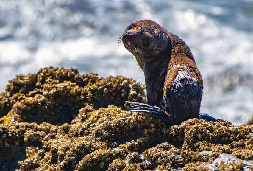
types are identified under the category ‘Northeastern bioregion Te Arai
Point to Miranda’. Of those nine ecosystem types, seven list ‘overfishing’ or
as in the case of the Outer Hauraki Gulf ‘overfishing resulting in trophic
cascade’ as a major threat.
1.4 Public concern at environmental decline and lack of official action.
Despite Parliament’s recognition of the national significance of the Hauraki
Gulf, its gazetting of the Hauraki Gulf as a marine park and its statutory
commitment to ‘protect and enhance in perpetuity’ its environment in 2000;
and despite the recognition of the threats to its priceless values by DOC’s
Conservation Management Strategy, very little has actually been done to
protect and enhance marine ecosystems and the ‘life-supporting capacity’
of the Hauraki Gulf. Especially by government agencies, and regional
councils (including Auckland Council) despite obvious indications of
environmental decline.
This deeply concerning trend has been highlighted in a series of Hauraki
Gulf ‘State of the Environment’ three-yearly reports produced by the
Hauraki Gulf Forum. Such reports are required under section 17 (1) (g) of
the Hauraki Gulf Marine Park Act. The first report was produced in 2005.
The most recent report in 2020, entitled ‘State of Our Gulf’ confirms a
continuing trajectory of environmental decline ‘since human arrival’ but
accelerated over recent decades. Among other findings, there is a major
and continuing decline in key fish stocks and marine biodiversity, including:
• 57% decline in key fish stocks
• 83% decline in snapper,
• 76% decline in crayfish,
• near 100% decline in green-lipped mussels,
• 86% decline in all shark species
• 97% decline in whales and dolphins (Appendix 3: Hauraki
Gulf Forum, State of Our Gulf 2020).
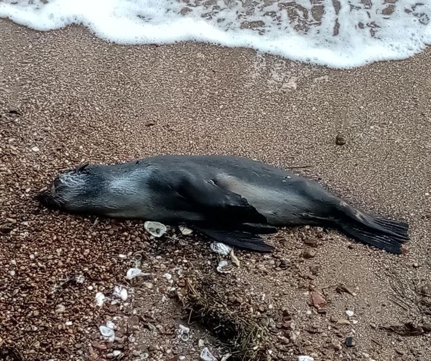
• A mass die-off of seal pups during the Spring of 2021.
In response to this alarming information (periodically the subject of high-
profile media attention), public support for meaningful conservation action
by taxpayer and ratepayer funded agencies, the government and regional
councils, to address the problem has grown.
A non-statutory ‘Spatial Plan’ for the Hauraki Gulf branded as ‘Sea Change
- Tai Timu Tai Pari’ largely sponsored by Auckland Council was completed
in 2017 but unfortunately along with the by-and-large exclusion of the
general public, conflicting objectives and interests of various stakeholders’
agendas, and the weight and influence of extractive resource users, nothing
tangible emerged from this process by way of meaningful marine
conservation measures. The ‘Sea Change’ report stated that ‘marine
7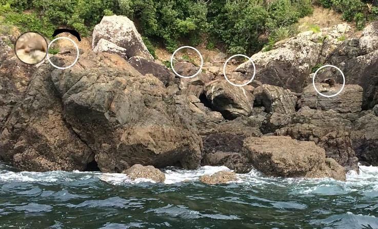
protection is best left to the government’ and thus was forwarded to the
    Ministers of Fisheries and Conservation.

    Unfortunately despite its Conservation Act (1987) mandate the Department
    of Conservation has not initiated any marine reserve proposals in northern
    New Zealand for more than a decade.

    In May 2019 the Hauraki Gulf Forum formally voted to support 20% of the
    Hauraki Gulf Marine Park being protected as a ‘long term aspirational
    goal’.1

    From early 2019 a ‘Waiheke Marine Project’ group conducted a series of
    private and public meetings, workshops and hui on Waiheke Island with the
    purpose ‘To protect and regenerate Waiheke’s marine environment’. This
    culminated in a ‘Future Search’ process in November 2020 facilitated by a
    city-based Department of Conservation officer. The process cost $150,000.
    Marine reserves were not considered and no other practical measures were
    adopted save a commitment to investigate.

    In January 2021, mana whenua iwi Ngāti Paoa, supported by the local
    Piritahi Marae declared a two-year rāhui against the taking of kōura /
    crayfish, tipa / scallops, pāua and kūtai / green-lipped mussels from around
    the coastline of Waiheke Island. This is arguably the most tangible attempt
    at marine resource conservation in the waters of the Hauraki Gulf in recent
    years. The rāhui is currently under consideration by the Ministry of Primary
    Industries under s186 (a) of the Fisheries Act. However a rāhui by definition
    is limited in time and scope and by itself cannot protect complete marine
    ecosystems and the myriad of biota therein.

    On Waiheke Island, awareness and concern among the island’s community
    about the state of the marine environment has long been evident. This was
    confirmed by professional opinion polling undertaken on behalf of the
    Waiheke Local Board by Colmar Brunton in 2015. The survey revealed
    strong public support (67%) from residents for marine protection of the
    waters around Waiheke and the inner Gulf, and 64% specifically in support
    of marine reserves (see section 2 & Appendix 4).

    The Waiheke Island community’s strong support for marine reserves is in
    keeping with its long history of environmental awareness and activism,
    especially in regard to the marine environment. In 1901 Waiheke Island
    residents drew up a petition objecting to the destructive impacts of trawling
    in the inner Gulf – one of several from Aucklanders at that time (Peart
    2016). In 1934 fifty Waiheke residents were among the first Aucklanders to
    express objections to the mid 20th century scheme to discharge the city’s

1
 A Hauraki Gulf Forum ‘Work Plan’ 2021 calls for 30% protection ‘medium term’
https://gulfjournal.org.nz/wp-content/uploads/2021/06/Work-Plan-Visual-09.pdf

8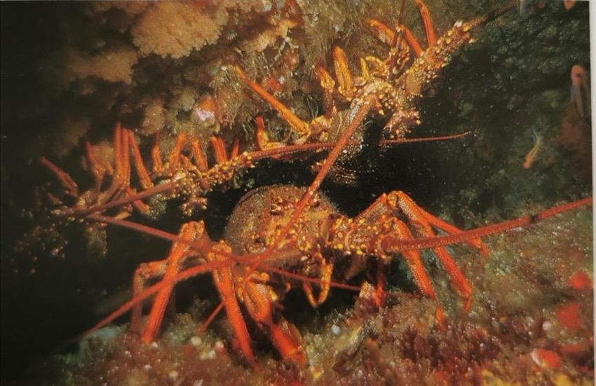
sewage into the Gulf at Browns Island / Motukorea. The scheme was
      famously overturned but only after a long and bitter battle led by Sir Dove-
      Myer Robinson (Bush 1980). Waiheke Island volunteers in large numbers
      led off the campaign to replant Tiritiri Matangi ‘open sanctuary’ in 1984
      (Rimmer 2004); Waiheke islanders were prominent in the eventually
      successful movement to stop marine dumping within the Hauraki Gulf and
      actively protested against the dumping contaminated harbour dredgings off
      the Noises Islands in 1992.

      Waiheke Islanders were also prominent in the long campaign to establish
      a Hauraki Gulf Marine Park. In the 1990s the Waiheke Royal Forest & Bird
      Protection Society branch successfully proposed a marine reserve at Te
      Matuku Bay on the south coast of Waiheke Island which was finally
      gazetted in 2005, the first since the establishment of the Hauraki Gulf
      Marine Park.

      The Waiheke community’s support for marine reserves is backed by
      science, going back to at least Ballantine (1991). Recent international
      research, notably Edgar et al. (2014) and Sala & Giakoumi (2017) has
      confirmed that no-take marine reserves are by far the most effective means
      of achieving marine protection.

Fig.5. An artist’s perspective view northward over the Hauraki Gulf. From an illustration in the 1983 publication Hauraki
Gulf Maritime Park. The painting is believed to be the work of the marine biologist, conservationist and passionate
advocate for marine reserves, Dr Roger Grace (1945-2019).

9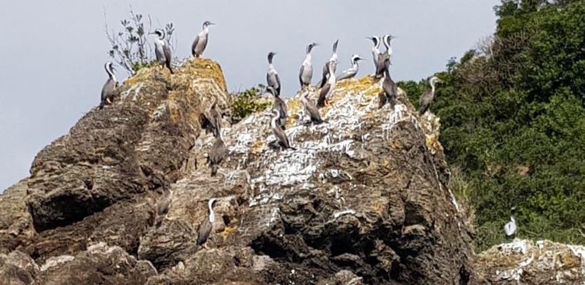
2.0 ORIGIN OF THIS PROPOSAL
2.1 The Friends of the Hauraki Gulf Inc

The Friends of the Hauraki Gulf is an incorporated society. Among its purposes
are:

‘to research and advocate for the setting aside of marine protected areas,
especially no-take marine reserves…’ and,

‘to encourage and facilitate the scientific study of marine life and the natural
history of the Hauraki Gulf.’

In 2013 the Friends of the Hauraki Gulf commissioned the first detailed
underwater topographic survey of the northwest Waiheke coastline. This was
carried out using side-scan sonar and undertaken by marine scientists Roger
Grace and Vince Kerr with the assistance of Dan Breen. This research resulted
in the paper Subtidal and intertidal habitats of the North coast of Waiheke Island
(Hauraki Gulf) (Kerr & Grace 2013). This was followed by a survey of 15 sites
in this area carried out by the University of Auckland Underwater Club.

An initial idea for a marine reserve on the northern coast of the island, though
winning support from the Hauraki Gulf Forum in June 2013, never proceeded
to a definitive application.

At this time the Waiheke Local Board assumed the leadership in progressing
marine protection around Waiheke.

2.2 The Waiheke Local Board

In 2014 the Waiheke Local Board consulted on its Local Board Plan,
highlighting an aspiration for a network of marine reserves around Waiheke
Island and relating this to a formal commitment to ‘improve protection and
conservation of our coastal environment including the marine area’ (Waiheke
Local Board Plan 2014-15).

After initial public consultation as part of its Local Board Plan in 2015 Auckland
Council, on behalf of the Local Board, commissioned the market research
agency Colmar Brunton to undertake an independent survey of registered
Waiheke voters and off-island residential ratepayers to determine public opinion
on the question of marine protection for Waiheke. The Colmar Brunton Survey
sought to ascertain public views on marine protection in general and marine
reserves in particular, via means of a postal and on-line public opinion survey.
A total of 1999 residents responded to the survey as follows:

10
•   ‘Total Support’ for marine protected areas from island residents was 67%
         and off-island ratepayers 54%.
     •   ‘Total Support for ‘no take’ marine reserves from island residents was
         64% with off-island ratepayers 52%. (Colmar Brunton, Bing, 2015). (See
         Appendix 4 and figures 25 & 26).

In May 2015 the Waiheke Local Board approved funding and in 2016
commissioned additional scientific assessment of five areas in the Coastal
Marine Area of Waiheke Island to advance the quest for formal marine
protection around Waiheke. These five sites were identified and demarked by
the Waiheke Local Board because they were largely contiguous with public land
and natural areas. In June 2016, Auckland Council signed a Services
Agreement with the Waiheke Local Board and the Hauraki Gulf Conservation
Trust granting funds for a ‘Marine Reserves Assessment on Waiheke’ which
was to include a final report and a colour brochure to present the results to the
Waiheke Community.

Marine biologist Dr Tim Haggitt of eCoast, a marine and freshwater
consultancy, was contracted by the council to evaluate and survey the five
potential marine reserve sites located on the northern and southern sides of the
island. This was undertaken in two parts. Phase One was a Gaps Analysis and
Feasibility Study of the five sites identified as PMR1, PMR2, PMR3, PMR4 &
PMR4a. This was completed in September 2016 (see Haggitt 2017a appendix
1).

A gateway review was undertaken by Auckland Council Infrastructure and
Environmental Services officers at this point. Approval was granted on 14
September 2016 to proceed to Phase Two which resulted in completion of the
Ecological Survey of Waiheke Island north-west coastline focussing on areas
designated PMR1, PMR4 & PMR4a in December 2016.

Almost a year later the reports were published on the Waiheke Local Board
agenda of 26 October 2017 and released for community consideration.

Upon formally receiving the eCoast reports Waiheke Local Board resolved:

That the Waiheke Local Board:

         a) agree to release and promote the reports for community consideration

          b) note that it does not consider it is the local board’s role to lead on any
         marine reserve applications(s) and encourages interested community groups
         to do so

         c) note its view that the material gathered to date provides a good and robust
         basis for pursuing a marine reserve(s)

11
d) agree to consider any requests for support and assistance from applicants
in due course
e) recommend that the Auckland Council Environment and Community
Committee and the Sea Change – Tai Timu Tai Pari Hauraki Gulf Political
Reference Group investigate incorporating the proposed Waiheke marine
reserves areas into the Auckland Council Sea Change – Tai Timu Tai Pari
implementation programme.
f) approve the production of a colour brochure by the Hauraki Gulf
Conservation Trust and delegate a board member to approve the scope.
Despite the Waiheke Local Board’s resolution, the Haggitt eCoast reports, and
the Colmar Brunton report which preceded them, were not formally accepted
by Auckland Council’s Environment and Community Committee. The colour
brochure despite being funded is yet to be produced. In short nothing further
was done to advance the Local Board proposal – until March this year. At this
time the Friends of the Hauraki Gulf, disappointed at the results of the two year
Waiheke Collective Marine Project ‘Future Search’ process, resolved to
proceed with a formal application for an order-in-council for a type 1 marine
reserve at northwest Waiheke, over the area identified and recommended by
Dr Haggitt as PMR1.
2.3 ‘Revitalising the Gulf’ – the government’s Sea Change proposals
In June the government released its ‘Revitalising the Gulf’ proposals, the long
awaited response to ‘Sea Change – Tai Timu Tai Pari, 2016’. Despite the
government’s statement that ‘The Gulf is badly degraded from human activities;
some fish and seabird populations are declining, and nature’s delicate balance
is being upset’’ the measures announced according to most marine
conservationists, fall short of dealing meaningfully with the crisis, let alone
‘revitalising’ the Hauraki Gulf.
The measures announced include undefined restrictions on trawling and
scallop dredging and also what the government called ‘new types’ of marine
protection. These comprise 5 ‘seafloor protection areas’, 11 modest sized ‘high
protection areas’ which are marine protected areas with exemptions for
‘customary’ fishing by iwi. There are additions to two existing marine reserves,
one at Cape Rodney to Okakari Point (Leigh) marine reserve and the other at
Whanganui a Hei (Cathedral Cove) marine reserve on the eastern Coromandel.
It appears that these additions may not have the same level of legal protection
as the adjacent marine reserves and may be open to some form of human
exploitation. The announced ‘high protection’ areas are experimental, subject
to negotiation and are not planned to come into force until the end of 2024.
There was not a single no-take marine protection area included in the
‘Revitalising the Gulf’ proposals.
123.0. THE APPLICATION
Hakaimango Point to Matiatia Point proposed Marine Reserve, northwest
Waiheke Island, Hauraki Gulf
(Ecological District. Inner Hauraki Gulf 09.05)
The proposed marine reserve in this application is located off the north western
coastline of Waiheke Island, from Hakaimango Point to Matiatia Point. It covers
c2300 ha of the coastal marine area of the Hauraki Gulf. The area was identified
after a series of scientific surveys and two comprehensive reports by Dr Tim
Haggitt (Haggitt 2017a & b) commissioned by Auckland Council and the
Waiheke Local Board.
Dr Haggitt considered the site he designated (PMR1) as being the preeminent
of the Local Board’s five identified possible marine reserve sites, as it
provides the best habitat and is of sufficient scale for protecting and
potentially restoring a whole range of marine biota, especially targeted
species like snapper and crayfish.(See Haggitt 2017a & b, Appendices 1 & 2).
Fig.6. Hakaimango to Matiatia Point, northwest Waiheke Island, showing boundaries of the proposed marine reserve
(GeoMaps).
133.1 Boundaries of the proposed marine reserve The boundaries of the proposed reserve from mean high water springs begin at Hakaimango Point at the north western extremity of Oneroa Bay at 36°46.133’ S, 175° 0.709’ E, thence to 36° 44.000’S, 175° 0.8709’E then northward for a distance of 2 nautical miles (3.7 km) [the eastern boundary], to 36°44.11638’ S, 175° 0.8709’ E, thence westward 2.62 nautical miles (4.85 km) [the northern boundary] to 36°44.11638’ S, 174° 57.5612’ E, then southward 2.74 nautical miles (5.08 km) [the western boundary] to 36°46.8396’ S, 174°59.100’E, then eastward 1.26 nautical miles (2.33 km, [the southern boundary] to Matiatia Point at 36° 46.8396 S, 174°59.100 E thence 36°48.00s, 174°59.116E. (Fig. 6 & Appendix 7 ‘The Plan’).2 These boundaries would encompass some 2300ha, making this the largest marine reserve in the Hauraki Gulf. Note. The Friends of the Hauraki Gulf proposal at 2300 ha is somewhat smaller than PMR1 (which was 2519.1 ha) as the southern boundary does not extend to the southern head of Matiatia Bay, Whetumatarau. Instead, the southern boundary of this proposal stops at the northern head of Matiatia Point and so does not include Matiatia Harbour. Due to Matiatia Harbour’s importance as a major transport hub; the need for periodic construction and other activities in the CMA, for instance to maintain wharf infrastructure, including it would introduce complexities into the application and future reserve management. Furthermore the Friends considers marine transport and other land-based transport activities and uses, including consented discharges for road and carpark stormwater outfalls and treated wastewater discharges would not be fully compatible with the Marine Reserves Act (s 3) requirement to manage a marine reserve in a ‘natural state’. Whereas the coastal foreshore, lying within the boundaries of this proposal from Matiatia Point to Hakaimango Point is in a ‘natural state’, with the coastal foreshore (adlittoral zone) bordered in regenerating native vegetation. Note that the Friends also recognise the popularity and convenience of recreational wharf fishing at Matiatia, especially for people who don’t own boats. It is proposed that the working name of the marine reserve be ‘Hakaimango – Matiatia (Northwest Waiheke Island) Marine Reserve’ based as with other marine reserves on navigational boundary features. The formal name would be a matter of decision for the Crown, the NZ Geographic Board - Ngā Pou Taunaha o Aotearoa and mana whenua, Ngāti Paoa. 2 Coordinate details, specifically decimal points of minutes of latitude and longitude are at this stage provisional and could change. 14
3.2 Māori History of the area Hakaimango Point to Matiatia Point

While ‘Matiatia Point’ is a well-known name and location, given the nearby ferry
terminal and wharf, ‘Hakaimango Point’ is less well known but has a fascinating
history. The name Hakaimango relates to the importance of shark fishing in the
Māori history of the Hauraki Gulf, in the late 18 th and mid 19th centuries
(Campbell et al. 2021)

By the 1790s the Marutūahu tribes (iwi of the Hauraki region) had extended
their summer fishing expeditions to the Mahurangi shark fishery, the richest
fishery in the Gulf, located between Kawau Island and Whangaparaoa.
Traditional sources state some 2000 rig sharks (Mustelus lenticulatus) known
to Maori as mangō or kapetā (lemonfish, spotted dogfish) were taken by Ngāti
Paoa on an annual basis from this fishery (Monin 2021).

The convergence of tribes from as far afield as the Firth of Thames, Manukau
and the Waikato sometimes produced flashpoints between strangers. Hence,
Ngāti Paoa repaired to their stronghold at the western end of Oneroa Beach to
dry and store their catch. Drying racks could be up to several hundred metres
long and could be smelt many kilometres away – hence the name Ha Kai
Mangō.

Fig. 7. Shark drying rack near Rangitoto circa 1850. Shark drying by Ngāti Paoa
at Hakaimango is believed to have been on a much more extensive scale with
some two thousand sharks dried and stored every season. (Charles Heaphy. Te Ara. Encyclopedia of New Zealand).

A significant find of Māori fishing gear, eroded from a midden, at that end of the
beach, is held by the Waiheke Museum. A 19th century colonial official who
expressly went to Matiatia in 1857 to meet the Ngāti Paoa chief Rawiri Takarua
(brother of Wiremu Hoete), found that he was unavailable, being away shark
fishing at Mahurangi (Monin 2021).

15
The Hakaimango pā site, which projects northwards at the western end of
Oneroa Beach, occupies a long narrow peninsula more than 300 metres in
length. No other headland pā on Waiheke boasts such spectacular natural
features. For defence, apart from palisading, three or possibly four transverse
ditches and associated banks were added to its precipitous slopes. The bulk of
the habitation is likely to have occurred between the second and the third
transverse ditches. The alignment of the peninsula, open to all day sun and
winds would have been ideal for shark drying.

Occupation of the pā by those returnees from the Mahurangi fishery would have
constituted only the final phase of the pā’s life. Suffice to say, the archaeological
record shows that the stretch of coastline between Matiatia and Oneroa,
between Mokemoke Pā and Hakaimango Pā, was alive with Māori activity, in
all probability dating back to the very beginnings of human settlement on
Waiheke. (Note the recent finds of an ‘Archaic’ Maori presence, 1300-1500 A.D,
at Otata in the Noises, a group of islands to the north of Waiheke’s western
end.)

Thus as the landward boundary of a marine reserve, Hakaimango comes with
a long, rich cultural heritage. This heritage has been formally acknowledged by
the Crown as part of the pending Treaty of Waitangi settlement with Ngāti Paoa
in the form of a Statutory Acknowledgement over the Department of
Conservation Matietie Historic Reserve. [Our thanks to historian Paul Monin for
this information.]

Fig 8. A view eastward to the Hakaimango peninsula & its cluster of islets & beyond along the northern coast of Waiheke
Island. The peninsula, once heavily fortified, was as its name suggests, used by Ngāti Paoa as a major shark drying
platform for rig sharks (Mangō) taken at the Mahurangi shark fishery. Photo Andy Spence.

3.3 The Coastal Marine Area (CMA)

16
The Resource Management Act Section 2 defines the coastal marine area:

coastal marine area means the foreshore, seabed, and coastal water, and
the air space above the water—
(a) of which the seaward boundary is the outer limits of the territorial sea:
(b) of which the landward boundary is the line of mean high water springs,
except that where that line crosses a river, the landward boundary at that point
shall be whichever is the lesser of—
(i) 1 kilometre upstream from the mouth of the river; or
(ii) the point upstream that is calculated by multiplying the width of the river
mouth by 5.

Therefore the coastal marine area encompasses all the land and water on the
seaward side of the line of mean high water springs out to a distance of 12
nautical miles. Twelve nautical miles is 22.2 kilometres. The line of mean high
water springs is the average of the high tides that happen just after every new
moon and every full moon.

The part of the Coastal Marine Area (CMA) proposed to be protected by this
application lies within a maritime ecological transition zone between the cooler,
shallow, turbid, low energy waters of the inner Gulf (Ecological District 09.05 in
which it is located), and the warmer, clearer, deeper, higher energy waters of
the outer Gulf. At its southern-most boundary at Matiatia Point, the proposed
reserve extends approximately 2km westward into the northern Motuihe
Channel. This channel lying to the west and north of the proposed reserve has
a moderate-to-heavy current flowing northward round the eastern headland of
Owhanake Bay, dissipating rapidly as it flows onwards past Hakaimango Point
and across the entrance of Oneroa Bay. The channel is relatively shallow
(Haggitt 2017b).

The proposed reserve would run from mean high waters springs (MHWS) to a
depth of 15-17 metres near its northern boundary (Marine Chart NZ 5324
Tamaki Strait and Approaches [including Waiheke Island]). The seaway of the
proposed reserve includes the ‘Harbour and Pilotage Limit’ line which runs
northwestward from the eastern head of Owhanake Bay to South Point at
Rakino. Submarine cables run from Cable Bay and Owhanake westward to
Home Bay, Motutapu.

The proposed reserve contains a diverse range of intertidal and subtidal marine
habitats, notably rocky reef systems, but also numerous gravel beaches and
sand beaches extending out to soft sediment sea floors framed by headlands
and extended complex reef systems.

The coastline of the reserve covers from the northeast Hakaimango peninsula,
to the remarkable Double U Bay which contains the geologically significant
Fossil Bay, then Island Bay, Owhanake Bay, Cable Bay and then

17
southwestwards towards Matiatia Point, the entrance to Matiatia Bay. In
between these named bays are innumerable beaches, some quite large,
varying in size down to gravel floored runnels, carved between weathered rocky
outcrops. As Haggitt (2017b) points out the boundary lines and scale of the
proposed reserve would be adequate to protect the species that occur within in
it and potentially enable them and others to be restored to more natural levels.

4.0 TYPES OF MARINE HABITATS WITHIN THE PROPOSED
MARINE RESERVE

The proposed marine reserve encompasses a remarkable variety of abiotic
environments which in turn provide rich habitats.

4.1 Rocky Reef Systems

‘Marine communities on the hard bedrock between tides are some of the richest
communities and the most accessible… Long before plants and animals were
well established on land, there were shore communities not unlike today’s. The
territory between the tides has clearly been a cradle for life on earth’. Professor
John Morton in A Natural History of Auckland (Morton et al. 1993).

The intertidal shoreline of northwest Waiheke Island is notable for its rocky,
cliffs, stacks, embayed islets and undersea reefs of eroded ancient Triassic to
Jurassic Waipapa greywacke (Eagle et al.1995). This rock was formed up to
300 million years ago and forms the bedrock of Waiheke Island. Unlike
mainland Auckland where it is deeply buried, because this ancient bedrock tilts
upward towards the east, it emerges at the surface at Waiheke Island.

The rocky reefs projecting from this section of Waiheke’s coast range in
gradient from steep to moderate-flat, and are often characterized by distinct
zonation bands (barnacles, oysters to macroalgae) from high to low tide. Within
the intertidal zone of the proposed marine reserve, rocky reefs comprise some
24 hectares (Haggitt 2017a). Intertidal rocky reefs are a particularly notable
feature of Waiheke’s indented northwestern coastline, especially between
Hakaimango Point and Owhanake Bay. Overlaying the ancient greywacke, is
sedimentary rock known as the Waitemata Group, which thickly covers the
Auckland isthmus, deposited in the Miocene epoch 20 to 25 million years ago.
In certain places this rock is fossil bearing.

18
4
Fig.9. The proposed marine reserve intertidal with kelp rich rocky reef terraces, interspaced with gravel and sand
beaches and soft sediment sea floor. Photo Mike Lee
.2 Reef types within the proposed marine reserve
The 24 ha of reef types within the proposed reserve include:
• Low lying platform reefs or terraces
• Complex platform reefs characterised by overhangs and crevices
• Terrace and boulder reef mix
• Boulder reefs
• Cobbles
(Haggitt 2017b).
These subtidal reefs typically extend to a depth of 10 to 15 metres. The subtidal
reefs in this area form the substrate for a particularly rich kelp forest habitat.
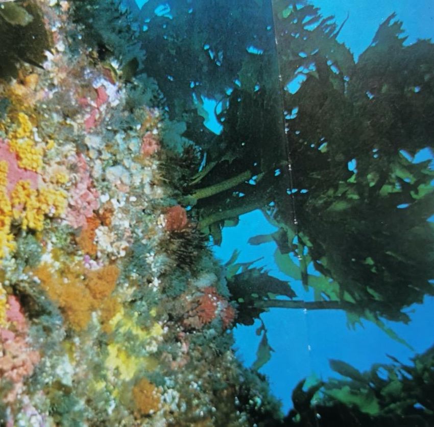
194.3 Soft sediment habitats Subtidal benthic habitats include large expanses of subtidal soft sediment that range from sand, sand and mud matrices, shell hash and gravel patches. The dominant soft sediment immediately adjacent to rocky reefs and the main channel area is a coarse sand and whole shells habitat featuring communities of erect sponges and red algae. At Owhanake Bay, in sheltered areas of the shallows at the northeastern corner of the bay, probably as a result of modification of the intertidal by historic quarrying of beach shingle, and accumulation of sediments, (possibly from nearby dredge dumping) there are areas of soft muddy flats. (Haggitt 2017b). With increasing distance offshore the sea floor transitions to fine muddy sand, especially in the main channel area along the western coastline of Waiheke. 4.4 The nationally important marine fossil deposits of Fossil Bay – Double U Bay Waiheke’s northwest coastline, east of Oneroa is particularly rich in fossils, especially at Double U Bay which includes ‘Fossil Bay’, its cliffs and intertidal platforms. The fossils here were discovered by a geology student W.Tetley in 1927 whose family had a house on Waiheke. He was joined by the famous biologist A.W.B. Powell and J.A. Bartrum. Together they found and described 78 fossilised ancient marine bivalves and gastropods. Subsequently many more fossils of long extinct corals and crustacea species have been discovered here. The area is a precious graveyard of the ancient ancestors and precursors of today’s marine species, which lived along the shore line of the continent of ancient Zealandia before it largely submerged beneath the sea some 23 million years ago in what is called the ‘Oligocene drowning’. Fossils of 91 different marine species have now been recorded from this locality (Eagle et al. 1995). The proposed marine reserve would not only throw a korowai of protection over today’s precious marine life but also the remains of their ancient ancestors. 5.0 BIOTA OF THE ROCKY REEF SYSTEMS The rocky reefs and submarine terraces projecting from the heavily indented coast line provide habitat for a diverse range of marine species. 5.1 Marine algal (seaweed) species Marine vegetation along this coastline is predominantly comprised of mixed algal habitat and algal habitat associated with subtidal reefs and terraces covering approximately 22 hectares within the proposed reserve (Haggitt 2017a). The balance is brown sea wrack mixed habitat / sponge flats. Twenty two different macroalgal species are recorded, ranging from large brown, canopy-forming kelps such as Ecklonia radiata and the fucoid seaweed Carpophyllum flexuosum through to fine filamentous turfing species. Species 20
diversity of the macroalgal habitat was particularly high east of Owhanake
(Haggitt 2017b).

The area from very shallow waters (10m) vegetation is
characterized by Neptune’s necklace (Hormosira banksii) (extensive areas at
Owhanake) co-occuring with brown seaweed (Xiphophora chondrophylla).
Between 2-3m depth the common kelp (E. radiata) occurs in discrete
monospecific stands alternating with similar sized patches of mixed fucoid
algae species such as (X. chondrophylla) with the brown fucoid algae, sea
wrack or flapjack (C.flexuosum and C. maschalocarpum).

Fig.10. Rocky reefs, a prominent feature of the proposed Hakaimango-Matiatia marine reserve, support rich kelp
forests, colourful sponge communities and sessile molluscs like green-lipped mussels. Photo Roger Grace from the
Story of Hauraki Gulf Maritime Park (1983).

Beyond the mixed algal zone i.e., between 3-15m depth, monospecific stands
of C. flexuosum commonly occur. In mid depths E. radiata described as ‘the
kauri of the sea’ is found at peak size and abundance (Haggitt 2017b).

21
The deeper parts of the proposed reserve are notable for the species diversity
of the marine vegetation. In addition to tall forests of brown flapjack, large
patches of the green seaweed, rimurimu (Caulerpa geminata) occur with ‘a rich
assemblage of ephemeral and perennial red foliose algae’ (Haggitt 2017b).
These deeper reef areas are also impacted by fine sediment, possibly from the
270,000 cubic metres of harbour dredgings dumped off the Noises Islands in
1992.

5.2 Marine invertebrates – mobile and sessile

At the highest level of the intertidal reefs below the lichen zone, is the periwinkle
zone. The common periwinkle (Littorina littorea) is a grazing sea snail. Below
the periwinkle zone are found the sessile barnacle communities: the column
barnacle (Chamaesipho columna), the brown barnacle and in more exposed
positions the volcano shaped surf barnacle (Epopella plicata) with areas of the
little black mussel (Xenostrobus pulex). Below the barnacles and mussels there
are extensive beds of oysters, the smaller Auckland rock oyster / tio reperepe
(Saccostrea glomerata), usually at more shallow levels, along with the more
prevalent Pacific oyster (Crassostrea gigas). Further out in deeper water are
found isolated patches of green-lipped mussels / kūtai (Perna canaliculus). This
area, especially the reefs projecting out on either side of Owhanake Bay once
supported high numbers of green-lipped mussels along with pāua (Haliotis iris)
before over exploitation over the past 30 years stripped them virtually bare (S.
Farqhuar pers. comm.).

Subtidal mobile invertebrates gastropods, crabs, urchins and chitons are
found in moderate to high diversity within the proposed protected area. These
include cats-eye (Turbo smaragdus = Lunella smaragda), Cook’s turban
(Cookia sulcata), southern periwinkle (Austrocochlea constricta), spotted
black topshell / pūpū (Diloma aethiops), green topshell (Coelotrochus viridis),
the brilliantly coloured butterfly chiton (Cryptoconchus porosus) and the mud
whelk (Cominella glandiformis), the large hermit crab (Pagurus
novizealandiae), sea cucumber (Stichopus mollis) and the cushion star
(Patiriella regularis). Kina or sea urchins (Evechinus chloroticus) are present
but in lower numbers than in Enclosure Bay to the east where kina barrens of
denuded kelp reefs are prevalent (Haggitt 2017b).

Sessile inverterbates include the encrusting sponge (Cliona cf.celata) and the
hard coral (Culicea rubeola). At greater depths the sea sponge (Halicondria
moorei), the erect branch sponge (Callyspongia ramosa), the large grey
sponge, (Ancorina alata), the orange golf ball sponge (Tethya burtoni),
ascidians or sea squirts, including Cnemidocarpa bicornuta, and solitary coral
(Monomycis rubrum), are common components of this habitat type (Haggitt
2017b). The build up of soft sediments at the northeastern side of Owhanake
Bay provide habitat for cockles / tuangi (Austrovenus stutchburyi) (S. Farqhuar
pers.comm). At greater depths there are occasional scallops / tipa (Pecten

22
novaezelandiae) and beds of unidentified bivalves. These fine sand / mud
habitats are also characterized by shrimp, worm and crab holes indicative of
abundant infaunal communities containing patches of horse mussels / hururoa
(Atrina zelandica). At greater depths still underwater species become less
evident except for occasional crab / shrimp / worm holes.

Fig.11. Normally abundant in rocky reef systems the crayfish (Jasus edwardsii) has been driven to near extinction
around Waiheke and the inner Gulf through over exploitation by people. Dr Tim Haggitt considers the area of the
proposed marine reserve with its plethora of submarine rocky reef crevices and overhangs is one of the best sites in
the inner Hauraki Gulf to enable the recovery of this important species. Photo Roger Grace from The Story of the
Hauraki Gulf.

5.3 Crayfish species

Crayfish or kōura, spiny rock lobster (Jasus edwardsii) and packhorse crayfish
(Sagmariasus verreauxi ) are, or rather were, key predator species in the
coastal reef system of the Hauraki Gulf. In the natural state or in protected areas
both species of cray would be expected to be found in high abundance.
However despite rigorous searches of crevices, ledges and boulder reefs in this
area in late 2016 as part of the eCoast survey, no crayfish were found. However
a more intensive search in June 2021 found both species present in the
proposed marine reserve albeit in low numbers, but in higher numbers than
other sites along the northern Waiheke coast (Thorburn 2021). The complex
reef systems within the proposed marine reserve are likely to be highly suitable
for crayfish which were present in this area in good numbers until the 1960s at
which time equipment became widely accessible for recreational scuba diving.
The low numbers of crayfish of both species in what should be ideal habitat can

23
only be attributed to excessive human harvesting. That they are still present
here while absent at many other sites is at least encouraging.

6.0 FISH SPECIES WITHIN THE PROPOSED MARINE RESERVE.

Fig.12. Snapper / tamure (Chrysophrys auratus), the iconic fish of the Hauraki, targeted by recreational and
commercial fishers alike, now under threat with stocks only at some 25% of virgin biomass. Dr Tim Haggitt considers
the area of the proposed marine reserve one of best sites around Waiheke to enable the recovery of this important
species. Photo Roger Grace from The Story of the Hauraki Gulf.

Cryptic reef fishes in the proposed marine reserve were found to be abundant
compared with other reefs in the Hauraki Gulf. These include the following triplefins:
spectacled triplefin (Ruanoho whero); mottled triplefin (Forsterygion malcolmi);
variable triplefin (F. varium); yellow and black triplefin (F. flavonigrum); common
triplefin (F. lapillum) [high abundance] scorpion fish (Scorpaenidae); slender roughy
(Optivus elongatus) [low to moderate abundance]; crested blenny (Parablennius
laticlavius) [low abundance] (Haggitt 2017).

Pelagic and larger reef fish, including commonly targeted finfish species such
as snapper / tamure (Chrysophrys auratus), kingfish / haku (Seriola lalandi
lalandi) and kahawai (Arripis trutta) are all present within the proposed reserve,
as is the endemic wrasse spotty / pakirikiri (Notolabrus celidotus) which is
numerically dominant here as in other parts of the inner Gulf – as opposed to
the outer Gulf. In regard to snapper ‘legal sized’ individuals and schools of
juveniles were found to be present at all sites, particularly around rocky reefs.

24
Other reef species recorded were the ray-finned fishes, red moki
(Cheilodactylus spectabilis), silver drummer (Kyphosus sydneyanus), NZ goat
fish or red mullet / ahururu (Upeneichthys porosus), the endemic koheru
(Decapterus koheru), silver sweep (Scorpis lineolata) and butterfish (Odax
Pullus). Also present was the leather jacket (Parika scaber) (a reef fish usually
found in the outer Gulf) and the benthic red gurnard / kumukumu
(Chelidonichthys cuculus) (Haggitt 2017). John Dory (Zeus faber) and Jack
Mackerel (Trachurus novaezelandiae) were not recorded during the survey but
should be present. New Zealand eagle ray / whai repo (Myliobatis
tenuicaudatus) frequent Owhanake Bay at full tide and nearby Matiatia feeding
in the shallows – a familiar sight and heartening reminder of the natural world
to Waiheke ferry commuters hurrying along the wharf from a day’s work in the
city.

Haggitt (2017b) points out that there is a paucity of data on how much fish (and
other sea food) is being harvested within the surveyed area – and all around
Waiheke. The area is routinely fished and is adjacent to the Motuihe Channel
and the Noises Islands which are subject to heavy recreational fishing pressure.
Despite the unremitting impact of human exploitation, ‘boil-ups’, spectacular
interactions between schooling fish such as pilchards, fish predators like
kahawai, kingfish, sharks, and sea birds, once a regular feature of the Hauraki
Gulf still occasionally occur in this seaway but on a much smaller scale.

7.0 SEABIRD SPECIES WITHIN THE PROPOSED MARINE
RESERVE

  ‘...many populations of resident seabirds remain in a poor state because of
  our devastation of the Gulf’s food webs through overfishing and habitat
  damage. Tara-iti / New Zealand fairy terns are but a few wing beats from
  extinction with only 39 individual birds, maintained only through intensive
  management from a dedicated team. The Hauraki parekareka / spotted
  shags are not far behind, hanging on in three small colonies.’

  Chris Gaskin State of our Seabirds 2021.

7.1 Seabirds foraging in or breeding near the proposed marine reserve

25
Fig.13. A scene more typical nowadays of the outer Gulf, and of Waiheke 50 years ago. Boil-ups still occur in the sea
around northern Waiheke, including in the proposed marine reserve, especially in the late summer. This photo is of a
‘boil-up’ in the Outer Gulf with mixed flocks of seabirds, petrels, shearwaters and terns and other sea birds, diving
into schooling kahawai, pilchards, kingfish and often including sharks. (Photo Frederic Pelsy, from Sea birds of the
Hauraki Gulf [Gaskin & Rayner 2017]).

The proposed marine reserve is also an important feeding ground for seabirds.
The State Of Our Gulf report (2020) reported a 67% decline in seabirds and
shorebirds within the Hauraki Gulf since the arrival of humans.

The State of our Seabirds 2021 report reveals that while seabirds feeding
outside the Hauraki Gulf are holding their own, seabirds in the inner gulf
continue to decline, notably Australasian gannets which appear to moving to
the outer Gulf. However the following species are recorded as breeding in the
general area:

     •    white-fronted terns / tara (Sterna striata)
     •    red-billed gulls / tarāpunga or akiaki (Larus novaehollandiae. scopulinus)
     •    southern black-backed gulls / karoro (Larus dominicanus)
     •    Australasian gannets / tākapu (Morus serrator)
     •    variable oystercatchers / tōrea (Haematopus unicolor)
     •    fluttering shearwaters / pakahā (Puffinus gavia)
     •    pied shags / kawau (Phalacrocorax varius)
     •    little shags / kawau paka (Ph. melanoleucos brevirostris)
     •    little black shags / kawau tui (Ph. sulcirostris)
     •    spotted shags / kawau pāteketeke (Stictocarbo p. punctatus)
     •    white-faced storm petrels / takahikare (Pelagodroma marina maoriana)
     •    grey-faced petrels / titi /ōi (Pterodroma macroptera gouldi)
     •    common diving petrels / kuaka (Pelecanoides urinatrix urinatrix) and

26
• northern little penguins / kororā (Eudyptula minor iredale) (Gaskin &
Rayner 2017).
Fig 14. Bullers Shearwater (Puffinus bulleri) a frequent visitor to the proposed marine reserve.
Photo Neil Fitzgerald from Sea birds of the Hauraki Gulf (Gaskin & Rayner 2017).
Furthermore the endemic Bullers shearwaters (Puffinus bulleri) which breeds
almost solely on the Poor Knights Islands, some 150 km to the north, are
regularly seen foraging in this area and further down the Motuihe channel,
especially during the late summer (Lee 1999).
Long term residents recall fluttering shearwaters, white-fronted terns and
spotted shags breeding on the cliffs and embayed islets of the northwest
coastline, (S.Farquhar; M. Delamore pers. comm).
Recently the community has shown its support and concern for local seabirds,
in particular kororā / little blue penguin. There has been significant media
coverage along with petitions and protests and legal proceedings relating to
disturbance of penguin nesting sites at Kennedy Point due to the construction
of a marina.
27Fig. 15. Northern little penguin / kororā (Eudyptula minor iredale) breeds along the coastline on the proposed marine reserve and on nearby islets. Little penguins are highly vulnerable to the loss of nesting areas and food sources. They feed in the area of the proposed marine reserve. Photo Adrien Lambrechts, The coastal fringe of the proposed marine reserve was partially surveyed in 2016 and 2017, along with 35 km of the island’s coastline by Auckland Council for penguins and petrels (Lovegrove 2017): https://infocouncil.aucklandcouncil.govt.nz/Open/2017/04/WHK_20170427_AGN_71 50_AT_files/WHK_20170427_AGN_7150_AT_Attachment_52854_1.PDF This revealed the area from Owhanake Bay to Matiaita to be a hotspot for penguin burrows. However the section Hakaimango Point to Owhanake Bay was not surveyed, presumably due to difficulty of access. One could reasonably presume this section of coastline, largely free from the impact of people and dogs would support as least as many penguin (and petrel) burrows as the rest of the area. 7.2 The restoration of spotted shags The Hauraki Gulf based spotted shag population has suffered ‘catastrophic decline’ over the past 50 or 60 years. While research into the foraging ecology of the spotted shag is underway (Rayner et al. 2021) surprisingly little is known about Hauraki Gulf spotted shag. That this species struggling back from the 28
You can also read