Modernization of GEONET from GPS to GNSS Hiromichi TSUJI, Kohei MIYAGAWA, Kazunori YAMAGUCHI, Toshihiro YAHAGI, Kenichi OSHIMA, Hiromi YAMAO and ...
←
→
Page content transcription
If your browser does not render page correctly, please read the page content below
Modernization of GEONET from GPS to GNSS                                               9

                             Modernization of GEONET from GPS to GNSS

     Hiromichi TSUJI, Kohei MIYAGAWA, Kazunori YAMAGUCHI, Toshihiro YAHAGI,
                 Kenichi OSHIMA, Hiromi YAMAO and Tomoaki FURUYA

                                         (Published online: 27 December 2013)

                                                        Abstract

       Since 1994, the Geospatial Information Authority of Japan (GSI) has been operating a continuous GPS
observation network system, later known as GEONET, for surveying and crustal deformation monitoring. On May 10,
2013, GSI started providing nationwide the observation data from the Quasi-Zenith Satellites System and GLONASS
in addition to GPS, opening the multi GNSS era in Japan. This report provides the background and history behind
this modernization of GEONET, the effect of the use of multi GNSS confirmed so far, and the plan for the future
modernization.

1. Introduction                                                GLONASS, and Galileo, modernization of GEONET is
       Currently, the Geospatial Information Authority          probably a never ending process, and improvements to the
of Japan (GSI) has Global Navigation Satellite System          analysis system and update of receivers for future GNSS
(GNSS) observation stations at approximately 1,300              will be mandatory. Therefore, the last chapter ends with
locations nationwide to conduct continuous GNSS                 the future plan.
observations to realize the geodetic reference frame
of Japan as well as to monitor crustal deformation.             2. Background
Observation data and analysis results are open to the           2.1 GEONET as Infrastructure
public to support public surveys and precise positioning               T h e d e p l o y m e n t of t h e G PS c o n t i n u o u s
services using GNSS.                                           observation station as we know it today as GEONET goes
       On May 10, 2013, GSI started providing                   back to 1993, and the operation of the initial observation
nationwide the observation data received from the Quasi-        network consisting of approximately 200 stations began
Zenith Satellites System (QZSS) and GLONASS in                 in 1994. At that time, the geodetic reference frame of
addition to the existing GPS, opening the multi GNSS era        Japan was Tokyo Datum, and the coordinates in the World
in Japan. GNSS is a generic name of satellite positioning      Geodetic System obtained from GPS could not be directly
systems such as GPS and GLONASS, including QZSS.                used for public surveys. Nevertheless, precise daily
       The entire system comprised of the observation          site coordinates of GEONET revolutionized the way to
stations all over Japan and the central station in Tsukuba      monitor crustal deformation, and contributed significantly
for collecting, analyzing and distributing its data is         in identifying the fault mechanisms of large earthquakes
called GEONET. Formerly, GEONET was a GPS Earth                such as Hokkaido East Offshore Earthquake in 1994 and
Observation Network system that supported GPS only,            Southern Hyogo Earthquake in 1995. Since then, more
but with the progress in GNSS implementations stated           GPS stations have been built, analysis systems have been
here, it has now evolved into a GNSS Earth Observation         integrated and modified, and there were 1,200 stations by
Network system.                                                2003 (Geodetic Observation Center, GSI, 2004). During
       In this report, the background and history of GNSS       these years, they detected crustal deformation following
implementation in GEONET will be described. Although            various earthquakes and volcanic activities serving for
GEONET stations are now ready for GPS, QZSS,                   disaster mitigation, and made academic discovery of slow
10                            Bulletin of the Geospatial Information Authority of Japan, Vol.61 December, 2013

slip events, i.e. earthquakes that are not accompanied by
seismic emission (e.g. Sagiya, 2004; Nishimura et al.,                            Stations
                                                                                                                                            North American
2013).                                                                                                                                      plate

         Following the enforcement of the Survey Act
Amendment 2002, the World Geodetic System was
adopted for public surveys in Japan, and official site
                                                                                                      Eurasian plate
coordinates of GEONET stations became available.
Observation data per 30 seconds were provided to the
public in the receiver-independent exchange (RINEX)
format, and were widely used as reference data of                                                                                       Pacific plate
GPS surveys. In 2002, the real-time data with 1 second
intervals were made open to the private sector, and
location-based service providers started network-based
                                                                                                           Philippine Sea plate
RTK positioning services. As explained later, this method
                                                                                   Nansei                                             Chichijima Island
                                                                                   Shoto
                                                                                   Islands
determines the position of a rover by cm level using the
                                                                                                                                                  Minamitori-
GPS data obtained at the rover and the correction data
                                                                                                                       Io To Island               shima Island

calculated from the surrounding GEONET stations, and
                                                                                                            Okinotorishima Island
has been used in public surveys, engineering surveys, and
cadastral surveys.
                                                                                    Fig.1    Distribution of GEONET stations
         Since GPS signals are affected by the atmosphere
between satellites and receivers, they contain information               stations at tide stations is under consideration, and the
on water vapor content in the air. Leveraging research                   number of GNSS-based control points in a broad sense
results on such “GPS meteorology”, the Ja pan                            will increase by about 30 in 2014.
Meteorological Agency began using the perceptible
water vapor computed from GEONET data in weather                         2.2 Expectations to GNSS
forecasting from October, 2009 (Japan Meteorological                              While GPS is a satellite positioning system
Agency and GSI, 2009). Moreover, since the state of                      developed by the U.S., the former Soviet Union followed
ionosphere can be estimated from dual frequency GPS                      suit and has developed GLONASS from the 1980s.
signals on L1 (1575.42MHz) and L2 (1227.60MHz) bands,                    Once the satellite positioning was recognized as socially
GEONET is also utilized as a tool in ionosphere research                 important infrastructure with the success of GPS, Europe
(e.g., Saito et al., 2002).                                              started developing their own satellite positioning system
         Therefore, it is not an exaggeration to say that                called Galileo from around 2000, followed by Japan
GEONET has become the infrastructure indispensable to                    starting the development of QZSS that compliments
support surveys, crustal deformation monitoring, location-               GPS. Through such efforts of countries, it was expected
based services, weather forecasting, earth sciences in                   that we would usher in the era where numerous satellite
Japan.                                                                   positioning systems will become available (Tsuji, 2010).
         So far 1,240 GEONET stations had been deployed                           If these GNSS are used in addition to the existing
as survey control points (Fig.1). However, considering the               GPS, more satellites can be observed simultaneously,
need of survey users, official site coordinates of GNSS                  allowing us to survey areas in urban cities and mountains
stations originally established for crustal deformation                  where receiving of satellite signals are difficult due to
monitoring are also provided to the public in recent years.              obstacles such as buildings and trees. Furthermore, as
Including these, there are 1,273 GNSS-based control                      there will be new L5 (1176.45MHz) signals, it is expected
points as of April 1, 2013. The inclusion of other GNSS                  that the time required for each survey can be shortened.
Modernization of GEONET from GPS to GNSS                                                                                11

For these reasons, users had been requesting early               site machines such as bulldozers, RTK with both GPS
implementation of GNSS in addition to GPS in GEONET,             and GLONASS were already adopted to observe enough
which are the survey infrastructure of Japan.                     number of satellites in areas such as mountains where
       Promotion Council of Real Time Positioning using          observation conditions are poor. If GLONASS data
GPS-based Control Stations is a private organization              becomes available in GEONET, users will not have to
established in 2001 for the promotion of use of GEONET           set up reference stations themselves. That is why there
real-time data and consists of survey companies,                  was high demand from the ICT construction industry for
receiver manufacturers, location-based service providers,        GNSS implementation in GEONET, which was reflected
communication carriers, universities, and others. The            in the Council's request.
Council’s Request submitted to GSI in June 2010 stated                                                                GNSS
their expectations as below by implementing GNSS in                     GLONASS
                                                                                                        GPS
                                                                                                                                GPS                        GPS

GEONET (Promotion Council of Real Time Positioning                Additional use of
                                                                  GLONASS enables
                                                                  ICT construction in
using GPS-based Control Stations, 2010).                          mountain areas!

1) There will be more areas and time that can be surveyed
                                                                                                                                       Reference station
  with satellites.                                                                                                                     in survey site is
                                                                                                                                       not required!
                                                                    Rover
2) There will be more demand for purchasing GNSS
  receivers, stimulating the market.                                Private Enterprises        Transmits correction data
                                                                    Generate correction        via cellular phones
3) The use in construction ICT is likely to be promoted             data

                                                                                 Distributes
  especially at construction sites in the mountains.                                                                           Rover
                                                                    Distributor                                   Combines satellite data and
4) Precise positioning with mobile devices will become              Check data quality                            correction data from GEONET
                                                                                                                  and computes the position of
                                                                                                                  rover in cm level.
  possible in urban areas, enabling to create 3D maps                                                                                                            GEONET
                                                                                                                                                                 Station
                                                                  Geospatial Information
  easily by mobile mapping systems, which will facilitate         Authority of Japan                    Observation data (real-time per second)

  the use of 3D maps.
                                                                     Fig.2       Schematic view of network-based RTK positioning
5) Precise GNSS positioning becomes available in
  wide areas in Japan without setting up one’s own
  GNSS stations, which will facilitate the use of GNSS            3. GNSS Implementation
  positioning.                                                    3.1 Initial Plan
       Since their main concern is on the application of                     The GEONET renewal plan in 2009 targeted
GEONET, GNSS positioning here refers to kinematic                 to install new receivers ready for GPS modernization
positioning that has the precision level of cm class, not to      by 2020 when the existing receivers of GEONET will
point positioning for car navigation. Real Time Kinematic         not be able to track L2 signals after the US planned
(RTK) positioning is a technique that performs this              GPS modernization (Tsuji, 2009). Fortunately, the
kinematic positioning of a rover in real-time. There are         supplementary budget of FY2008 and the budget of
two methods of RTK: 1) A user places a reference station          FY2009 allowed renewal of aging receivers at 450
on the site and transfer the data to the rover by wireless       stations, so the plan was modified to renew 80 units
transmission; and 2) A user calculates the rover position        annually for the following 10 years and to complete
by receiving the correction data of the surrounding              GNSS implementation at all GEONET stations by 2019.
GEONET stations via cellular phones (Network-based               GPS modernization also required renewal of antennas to
RTK) (Fig.2).                                                     receive newly added L5 signals, but the schedule of the
       To achieve the precision of cm level in real-time,        antenna renewal was not decided.
at least five satellites should be observed simultaneously.                  In September 2010, Japan’s first QZSS “Michibiki”
Therefore, in the field of construction ICT (intelligent          was launched successfully. In parallel, Russia’s GLONASS
construction), which controls and guides construction            completed satellite deployment. Confirming user needs,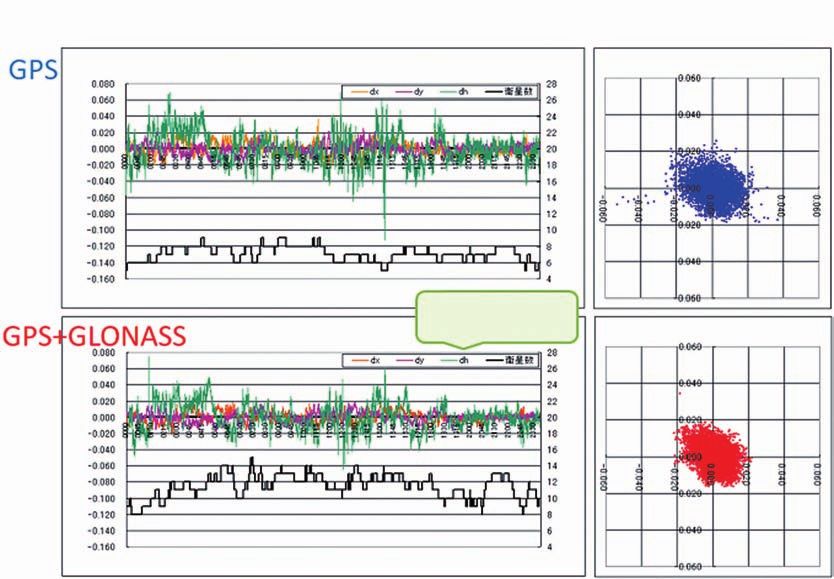
12                           Bulletin of the Geospatial Information Authority of Japan, Vol.61 December, 2013

GSI decided to observe and provide QZSS and GLONASS
data in addition to modernized GPS and Galileo, but
the expected completion of GNSS implementation at all
GEONET stations was not until 2019.

3.2 Early Renewal after the 2011 off the Pacific coast
     of Tohoku Earthquake
         The 2011 off the Pacif ic coast of Tohoku
Earthquake changed the whole situation. The crustal
deformation caused by this unprecedentedly large M9.0                                                    Provided from July 13, 2012
earthquake was recorded in detail by GEONET, which                                                       Provided from April 1, 2013
                                                                                                         Provided from May 10, 2013
contributed to disaster mitigation after the quake, seismic
research and restoration surveys (Nishimura et al., 2011;
Suito et al, 2011; Yamagiwa et al., 2012).                                Fig.3    GNSS data provision from GEONET. In response to
                                                                                   the 2011 Tohoku earthquake, Tohoku area was the
         Although backup communications by cellular
                                                                                   first to be renewed and provide GNSS data.
phone and reinforced UPS systems at each station helped
to prevent the operation shutdown of GEONET in Tohoku
area immediately after the quake, the prolonged blackout                3.3 Renewed Equipment
and communication interruption destroyed some of the                              Receivers and antennas used as of April 2013
important observation data after the quake (Oshima et al.,              are shown in Table 1. Since renewal could not complete
2011).                                                                  in the Okinotorishima island and in the vicinity of
         This led to the renewal of GEONET receivers                    the Fukushima first nuclear power plant, the total for
and antennas under the FY2011 supplementary budget,                     GEONET stations is different from the figure mentioned
in order to recover GEONET stations damaged from                        earlier. All receivers support signals of modernized
the disaster and to secure the continuity of the crustal                GPS (except for L1C), QZSS, GLONASS and Galileo.
deformation monitoring that is critical in disaster                     TRM59800.80 is a triple-frequency choke ring antenna
mitigation. As a result, almost all GEONET station                      reworked from an old TRM29659.00 with a replacement
equipment would be renewed by the end of March                          amplifier (Fig.5). It has the same properties as L5-
2012. However, since the development of the system                      supporting choke ring antenna TRM59800.00.
for collecting / distributing GNSS data takes a certain
period of time, it was to be done by 2013. At this point,               3.4 RINEX Data
GNSS implementation in GEONET was virtually pushed                                Standard operating procedure of the public surveys
forward to 2014.                                                        set into action on April 1, 2013 enables a combined use
         Later, to further assist in recovery from the                  of GLONASS and QZSS together with GPS (Technical
disaster, it was decided to provide QZSS and GLONASS                    Management Division, Planning Department, GSI, 2013).
data from areas where equipment was renewed. In July                    GNSS data from GEONET stations are available for these
2012, GNSS data provision started in the Tohoku area,                   public surveys from the GSI website (http://terras.gsi.
and in April 2013 data from 541 stations including East                 go.jp/ja/index.html).
Japan, and from May 2013 data from all stations have                              Assuming various users, 3 types of data files are
been provided (Fig.3). Fig.4 illustrates this GEONET                    provided (Table 2). All types contain observation data per
modernization process.                                                  30 seconds and broadcast ephemerides in RINEX format.
                                                                        Recently, RINEX ver. 3.02 that officially supports QZSS was
                                                                        released, and we will provide the data with it from 2014.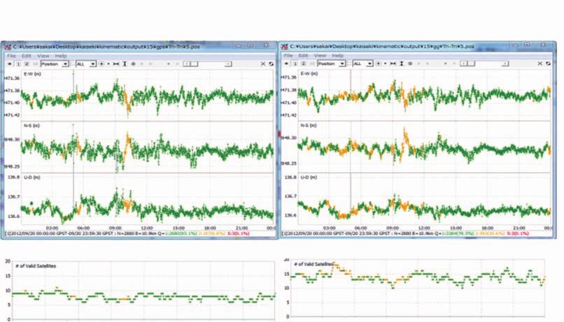
Modernization of GEONET from GPS to GNSS                                         13

                                       Fig.4 Time schedule of GEONET modernization

   Table 1   Renewed GNSS Equipment (as of April 2013)                  Table 2 Types of files provided on the GSI website

      Receiver                  Antenna               unit            Satellite System           Format           Frequency
Trimble NetR9         Trimble TRM59800.80              800          GPS                    RINEX ver.2.10           L1, L2
Trimble NetR9         Trimble TRM59800.00                   3       GPS+GLONASS            RINEX ver.2.10           L1, L2
Topcon NET-G3A Trimble TRM59800.80                      19          GPS+GLONASS            RINEX ver.2.12         L1, L2, L5
Topcon NET-G3         Topcon TPSCR.G5                  448          +QZSS                  QZSS-supported

                                                                   3.5 Real-time Data
                                                                          GSI started real-time data transfer with 1 second
                                                                  intervals from 200 stations to the central station in
                                                                  Tsukuba in May 2002, from 645 stations in June, and
                                                                  from 931 stations in October 2002. Today, 1,220 stations,
   Fig.5   Antenna being renewed (left) and GNSS receiver
                                                                  excluding those in isolated islands and deep mountains,
           (right)
                                                                  are transferring observation data per second in real-
        According to the web statistics on the access              time. Such data are used for emergency analysis upon
to RINEX data from June to September 2013, survey                 earthquakes and volcanic activities, as well as for the
engineers downloaded a monthly average of 23,000 files            source of RINEX data of 30-second intervals. They are
in total, 3,000 with GLONASS, and 300 with QZSS from              also provided via a distributor to private enterprises
our http site. From our FTP site, researchers downloaded           that generate correction data of network-based RTK for
a monthly average of 7.85 million files in total, 40,000          location-based services. For a few stations where IP-VPN
with GLONASS, and 80,000 with QZSS. As provision of               (Virtual Private Network via wide area IP network) is not
GNSS data has just started, their use is expected to grow         available, observation data per 30 seconds are collected in
in the future.                                                    a batch every hour via ISDN, cellular phone, or satellite
                                                                  cellular phone lines.
                                                                          Initially, receiver manufacturer’s real-time data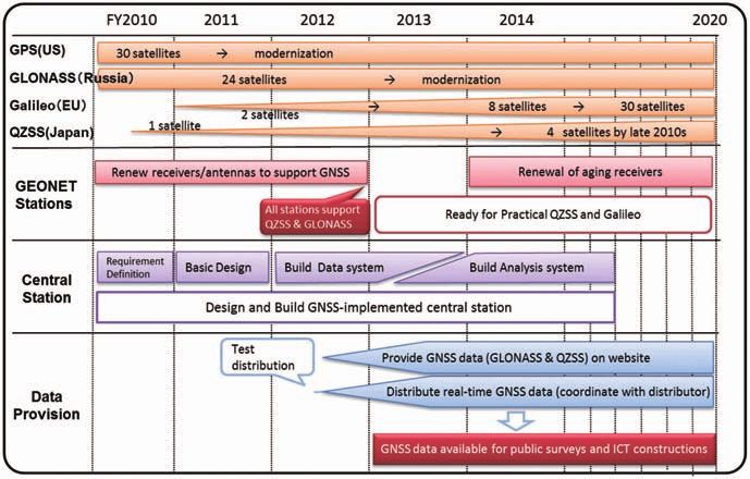
14                                                    Bulletin of the Geospatial Information Authority of Japan, Vol.61 December, 2013

formats such as RT17 or JPS had been used, but from                                                                                            hidden in communication server transfer programs were
2009 the standard real-time data format named BINEX                                                                                            found and fixed. We also modified the timing of data
developed by a U.S. non-profit university-governed                                                                                             flow so as to reduce traffic around every second on the
consortium is being used (UNAVCO, 2011). In the area of                                                                                        second. As a result, the average delay time was shortened
navigation, RTCM SC104 is more popular, but because it                                                                                         to around 0.2 to 0.3 seconds, enabling GNSS data
does not support QZSS as of April 2013, and BINEX has                                                                                          distribution from all stations by May 2013.
more significant digits for observation data, we continue                                                                                               However, in some stations, delay of more than 1
to use BINEX.                                                                                                                                  second still occurs once in a while (Fig.7). Although this
              Now the final obstacle in pushing forward the                                                                                    frequency of delay will not degrade the network-based
start of GNSS data provision was the increased delay                                                                                           RTK service, investigation is underway to find the cause.
of real-time data. Real-time data are provided to private                                                                                      What is interesting is that delay time does not seem to
enterprises via distributor in BINEX streaming (Fig.6).                                                                                        depend on the distance between each station and the
For communication with each station, 64 kbps IP-VPN                                                                                            distributor server at Shinjuku so much. This is probably
is dedicated. Since the GPS observation data size is 3                                                                                         such that the delay time is sufficiently small within IP-
kbps or less, and about 7 kbps even with QZSS and                                                                                              VPN.
GLONASS, we did not expect any problems at first.                                                                                                       Real-time data are planned to be used for
However, as we proceeded with the receiver renewal and                                                                                         generation of centimeter-level augmentation signals to be
data distribution, we gradually experienced increased                                                                                          distributed from full-scale QZSS (Cabinet Office, 2012),
delay of real-time data.                                                                                                                       therefore the data delay time becomes the important
              Signals observed every second at each receiver                                                                                   quality factor of GEONET. In 2013, communication
have exact time stamp as is the nature of GNSS, so by                                                                                          servers and lines in KDDI Shinjuku Data Center, where
comparing to the arrival time of the signal packet at the                                                                                      all GEONET data gathered from across the country, will
distributor's server in the Shinjuku Data Center, the delay                                                                                    be strengthened, aiming to provide more reliable real-
time between each station and Shinjuku can be measured.                                                                                                                                         Ibaraki Pref
                                                                                                                                                                      Tsukuba 3
The distributor has a dedicated time server to correct the
server time, keeping the precision of measured delay time
better than 0.1 seconds.
              When only with GPS, the delay time was about
0.3 seconds, as data size and observation stations with
                                                                                                                                                                                                   Hokkaido
                                                                                                                                                                         Esashi
GNSS increased, delay time increased gradually up to
near 1 second every several hours, and in some stations
delay exceeded the limit of 1 second. Therefore, data
transmission lines were carefully inspected, and bugs

                                                                                                                                                                                               Nagasaki Pref
                                                                                                                                                                         Omura
                                         Data delay time

                                                                           DC in Shinjuku
                                                                                                                             Real-time Users

                  NTT East/West
                                                                                                               Enterprises
                                                                                            Distributor

     Router                                                                      GSI rack
              Metal

                        Dedicated line
                                                                        Change to 200M

                                                                               Change to
                                                                               Ether100M
                                                                                                                             Survey Users
                                                                                                GSI Web Site

                                                   3F Server                                                                                    Fig.7   Examples of delays in real-time data on October
                                                           1F Server                                                                                    10, 2013. The horizontal axis is Universal Time, the
                                                GSI Space Geodesy Lab
                                                                                                                                                        vertical axis is delay time (ms). Normally, the delay
                                                                                                                                                        time is about 0.2 seconds (top), it may sometimes be
        Fig.6           Data flow of GEONET from stations to users                                                                                      more than 1 second (middle and bottom).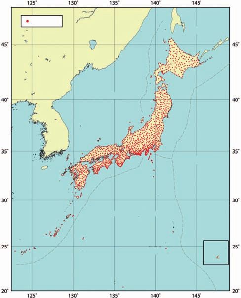
Modernization of GEONET from GPS to GNSS                                           15

time data.                                                         GSILIB prototype, modified by GSI based on RTKLIB
                                                                    ver.2.4.1, was used (Furuya et al., 2013a). Fig.10 shows
4. Effect of GNSS Implementation                                   an example of time series of kinematic analysis for 3
4.1 Precision of Baseline Analysis                                  hours among different types of receivers in the calibration
       Simple baseline analysis using GEONET data                   baseline (distance: 11km). Table 4 shows standard
was conducted on the precision of surveys when QZSS or             deviations of kinematic solutions of 36 baselines (10 to
GLONASS was combined with GPS.
       First, using the Tohoku area’s data and broadcast             Table 3 Results of kinematic baseline analysis between
ephemerides obtained on September 20, 2012, kinematic                        GEONET stations. Average standard deviation
                                                                             of 16baselines in Tohoku area on September 20,
analysis of 30-second intervals by analysis software
                                                                             2012. Minimum elevation angle is 15°.
RTKLIB ver.2.4.1 (Takasu, 2011) was conducted for 16
                                                                                                        GPS+         GPS+
baselines between the same types of receiver within 10               Component          GPS only
                                                                                                      GLONASS        QZSS
to 30km range (Furuya et al., 2012). When GLONASS                     East-West          8.6 mm        7.7 mm        8.6 mm
was used together, the standard deviation of coordinates             North-South        12.2 mm        8.7 mm       11.4 mm
for one day decreased by 10 to 30 percent compared to                 Up-Down           30.3 mm       25.7 mm       31.2 mm
GPS only (Table 3). This is considered to be the effect
of having improved repeatability in time zone when the               Table 4 Results of kinematic baseline analysis between
                                                                             GEONET stations. Average standard deviation of
number of satellites is small (Fig.8). The effect of using
                                                                             36 baselines on May 10, 2013 (14:00~20:00 UT).
QZSS together is not so significant since there is only one
                                                                      Minimum
satellite, but as the minimum elevation angle for analysis                                                            GPS+
                                                                      Elevation      Component        GPS only
                                                                                                                      QZSS
is raised, i.e. as observation conditions become worse, the            Angle
effect of combined use gets bigger (Fig.9).                                             East-West      6.8 mm        6.7 mm
       The effect of combined use of QZSS was further                    15°        North-South        8.8 mm        9.2 mm
analyzed using the data obtained at Tsukuba GNSS                                        Up-Down       24.5 mm       25.4 mm
calibration baseline on November 26, 2012 and at                                        East-West      7.8 mm        7.0 mm
GEONET stations on May 10, 2013. As analysis software,                   30°        North-South       11.9 mm       11.5 mm
                                                                                        Up-Down       45.6 mm       42.5 mm

                                    GPS                                      GPS + GLONASS
               (Standard deviation [mm] EW7.2, NS9.0, UD23.6) (Standard deviation [mm] EW6.5, NS7.2, UD18.4)

                             Number of satellites                              Number of satellites

    Fig.8    Time series of kinematic baseline analysis between GEONET stations (Onoda to Shikama, distance 11 km) for 1 day.
             Left: GPS only. Right: GLONASS is used together. Minimum elevation angle is 15°.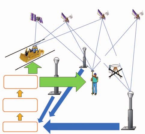
16                              Bulletin of the Geospatial Information Authority of Japan, Vol.61 December, 2013

                                       GPS               Elevation angle 30˚                GPS + QZSS
                  (Standard deviation [mm] EW8.9, NS12.9, UD30.9)         (Standard deviation [mm] EW8.7, NS13.8, UD26.7)

     Fig.9    Time series of kinematic baseline analysis between GEONET stations (Onoda to Shikama, distance 11 km) for 1 day.
              Left: GPS only. Right: GLONASS is used together. Minimum elevation angle changed to 30°.

                                  GPS                   Elevation angle 15˚                   GPS + QZSS
             (Standard deviation [mm] EW5.3, NS12.0, UD34.5)               (Standard deviation [mm] EW5.3, NS12.6, UD34.9)

                            Fix rate 93.6%                                                    Fix rate 92.2%

                                  GPS                   Elevation angle 30˚                   GPS + QZSS
             (Standard deviation [mm] EW6.4, NS13.5, UD45.7)               (Standard deviation [mm] EW6.6, NS14.5, UD41.0)

                            Fix rate 83.7% Float solution                                     Fix rate 98.1%
Fig.10 Time series of kinematic baseline analysis at the GNSS calibration baseline (distance: 11 km) for 3 hours.
       Left: GPS only. Right: QZSS used together. Top: Minimum elevation angle 15°. Bottom: Minimum elevation angle: 30°.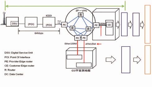
Modernization of GEONET from GPS to GNSS                                                                                                17

70 km) between GEONET stations with the same type                                                          the same time, enabling stable positioning 24 hours a day
of receivers in the vicinity of Wakkanai, Akita, Tsukuba,                                                  (Promotion Council of Real Time Positioning using GPS-
Osaka and Kochi. No systematic errors were found when                                                      based Control Stations, 2013). Please note that stability of
QZSS was combined with GPS, and if the minimum                                                             height improved by combined use of GLONASS in the
elevation angle is 30°, the fix ratio of integer ambiguity                                                 actual network-based RTK (Fig.11).
and vertical repeatability improves with the use of QZSS
(Furuya et al., 2013b).                                                                                    4.3 Application to Intelligent Construction
        To summarize, in places where observation                                                                 In October 2012, the network-based RTK with
conditions are good, GPS is enough to get sufficient                                                       GLONASS data from GEONET was utilized in intelligent
precision, but in places where observation conditions are                                                  construction at the construction site of the Sanriku
poor, combined use of GNSS enables the same level or                                                       Jukan Expressway in Miyagi Pref. for recovery from the
higher precision. We will further examine the effect of                                                    aftermath of the Tohoku earthquake. It earned a reputation
shortening of observation time in static positioning with                                                  that said, “Thanks to GNSS implementation in GEONET,
GNSS.                                                                                                      satellite reception restrictions were significantly reduced.”
                                                                                                           (Fukukawa, 2012).
4.2 Network-based Multi-GNSS Experiments                                                                          According to the Intelligent Construction Strategic
        The Council performed network-based RTK-                                                           Plan compiled by the Ministry of Land, Infrastructure and
GNSS experiments in Hokkaido, Tohoku and Kansai                                                            Transport in March 2013, “Satellite positioning technique
areas using GPS and GLONASS data from GEONET                                                               using the network-based RTK method is expected to
delivered in 2011 and 2012. It was confirmed that if                                                       expand the time and locations that can be positioned and
GLONASS is used, more satellites can be observed at                                                        to improve the stability by combined use of GNSS other

                                                    Time series of VRS positioning for 1 day                                                            Horizontal Distribution (m)
                                                           Shift in Coordinates (GPS observation)                                                      Horizontal Distribution (GPS observation)

                                                                                                                   Number of
                                                                                                                   Satellites
                   Difference from average (m)

                                                                                                                                Number of Satellites

                                                                Observation Time (JST)
                                                                                                          Height becomes
                                                       Shift in Coordinates (GPS + GLONASS observation)
                                                                                                          more stable.                                 Horizontal Distribution (GPS + GLONASS observation)

                                                                                                                   Number of
                                                                                                                   Satellites
                      Difference from average (m)

                                                                                                                                Number of Satellites

                                                                   Observation Time (JST)

              Fig.11 Example of network-based RTK performance with GLONASS. One day time series using
                     Jenoba’s Virtual Reference Station method (VRS). Minimum elevation angle is 15°. (Promotion
                     Council of Real Time Positioning using GPS-based Control Stations, 2013, p.24, modified)
18 Bulletin of the Geospatial Information Authority of Japan, Vol.61 December, 2013
than GPS in the future. Since the network-based RTK receivers, antennas, analysis software and the GEONET
does not require setting up of a reference station in each operations. As GNSS other than GPS increases, there will
construction site, this technology is expected to extend be more size and types of data to be handled, and their
its use in intelligent construction” (Council for Intelligent increasing possible combinations will make users harder
Construction Strategy, 2013). to make full use of them. However, there will be new
Today, there are two providers of network-based developments expected in the era of multi GNSS when
RTK services in Japan; Jenoba Co., Ltd. and Nippon satellite positioning data from more than 100 satellites
GPS Data Service Corporation. Both companies have flourish. GSI will continue to enhance GEONET as the
started network-based RTK using GLONASS data infrastructure as well as develop the environment in which
from GEONET since May 2013. According to them, multi GNSS can be fully used effectively for surveys and
about one third of users have already tested GLONASS positioning in Japan.
data, and that the use of GNSS in the field of intelligent
construction would expand further in the future. For Acknowledgements
contact information, please refer to the website of the Early provision of GNSS data from GEONET
Council (http://www.jsurvey.jp/pcrg/kyougikai.htm). was the result of mutual collaboration with the Promotion
Council of Real Time Positioning using GPS-based
5. Future Plan Control Stations, Japan Association of Surveyors, and
Although GEONET receivers are now ready Hitachi Zosen Corporation. We thank the contribution
for the current GNSS, implementation for future GNSS from Mr. Naohiro Abe in the evaluation of GSILIB
would be required. As for Galileo's L6 signal and CDMA prototype during his 6 month stay at GSI.
signals of modernized GLONASS, user needs must be
carefully confirmed. Since antennas have been upgraded References
for triple frequency to support L5 signals, no further Cabinet Office (2012): Draft Standards for operating the
upgrade will be required for the time being. Quasi-Zenith Satellites system, http://www.cao.go.jp/
A new data collection system named GATE chotatsu/eisei/hoshin/1209_shiryo1.pdf (accessed 11
(Gather and Transfer Engine) that supports GNSS is being Oct. 2013). (in Japanese)
developed from 2012. In 2013, communication servers and Council for Intelligent Construction Strategy (2013),
bandwidth of lines in Shinjuku will be enhanced to secure Intelligent Construction Strategic Plan, March 29,
high reliability as a source to generate augmentation data 2013, http://www.mlit.go.jp/common/000993270.pdf
for full-scale QZSS in the future. (accessed 11 Oct. 2013). (in Japanese)
Regarding data analysis, the use of QZSS and Fukukawa, M. (2012): The 11th meeting of the Council for
GLONASS will be considered first in the real-time Intelligent Construction Strategy , Material 4, October
analysis of GEONET which are under development for 19, 2012, http://www.mlit.go.jp/common/000227614.
tsunami early warning assistance following the Tohoku pdf (accessed 11 Oct. 2013). (in Japanese)
earthquake (Ohta et al., 2013). Regarding the routine Furuya, T., K. Sakai, H. Tsuji, S. Kawamoto, T. Toyoda,
analysis for crustal deformation monitoring that seeks H. Morishita, T. Yahagi, H. Hirai, N. Ishikawa, S.
maximum precision, the results from multi-GNSS Nemoto, K. Miyagawa, B. Miyahara, Y. Hatanaka and
analysis technology developed separately by the General H. Munekane (2012): Development of a new precise
Technology Development Project of the Ministry of positioning technique using multi-GNSS signals,
Land, Infrastructure and Transport will be incorporated Abstract of the 118th meeting of the Geodetic Society
(GSI, 2013). of Japan, 53-54. (in Japanese)
Come to think of it, when GPS was the only Furuya, T., K. Sakai, M. Mandokoro, H. Tsuji, K.
GNSS available, everything was simple including the Miyagawa, Y. Hatanaka, H. Munekane and S.Modernization of GEONET from GPS to GNSS 19 Kawamoto (2013a): Development of Multi-GNSS Restoration of Damaged GPS and Tide Stations after Analysis Software for Precise Surveying, Journal of the the 2011 off the Pacific coast of Tohoku Earthquake, Japan Society of Photogrammetry and Remote Sensing, Journal of Geospatial Information Authority of Japan, 52, 4, 159-164. (in Japanese) 122, 113-125. (in Japanese) Furuya, T., K. Sakai, M. Mandokoro, H. Tsuji, K. Promotion Council of Real Time Positioning using GPS- Yamaguchi, S. Kawamoto, K. Miyagawa, T. Yahagi, Y. based Control Stations (2010), Request on Renewal Hatanaka, and H. Munekane (2013b): Status report of of the GPS-based Control Stations into GNSS, http:// the approach for geodetic survey using QZSS signals, www.jsurvey.jp/pcrg/kyougikai.files/youbou_01.pdf Abstract of the 57th meeting of the Japan Society for (accessed 11 Oct. 2013). (in Japanese) Aeronautical and Space Sciences, JSASS-2013-4496. (in Promotion Council of Real Time Positioning using GPS- Japanese) based Control Stations (2013): The report of Multi- Geodetic Observation Center, GSI (2004): Establishment GNSS demonstration campaign, January 2013, 172pp. of the nationwide observation system of 1,200 (in Japanese) GPS-based control stations, Journal of the Geographical Sagiya, T. (2004) : A decade of GEONET: 1994-2003 -The Survey Institute, 103, 1-51. (in Japanese) continuous GPS observation in Japan and its impact on GSI (2013): Development of a precise positioning earthquake studies-, Earth, Planets and Space, 56, 29- technique using multi-GNSS for advanced management 41. of national lands, http://www.gsi.go.jp/eiseisokuchi/ Saito, A., M. Nishimura, M. Yamamoto, S. Fukao, T. gnss_main.html (accessed 11 Oct. 2013). (in Japanese) Tsugawa, Y. Otsuka, S. Miyazaki and M.C. Kelly (2002), Ja pan Meteorological Agency and GSI (2009): Observations of traveling ionospheric disturbances Improvement of Meso-Scale forecasting of JMA using and 3-m scale irregularities in the nighttime F-region GSI's GPS data, press release, http://www.jma.go.jp/ ionosphere with the MU radar and a GPS network, jma/press/0910/27a/MSM_GPS.pdf (accessed 11 Oct. Earth, Planets and Space, 54, 31-44. 2013). (in Japanese) Suito, H., T. Nishimura, S. Ozawa, T. Kobayashi, M. Nishimura, T., H. Munekane and H. Yarai (2011) : The Tobita, T. Imakiire, S. Hara, H. Yarai, T. Yahagi, 2011 off the Pacific coast of Tohoku Earthquake and H. Kimura and S. Kawamoto (2011): Co-seismic its aftershocks observed by GEONET, Earth Planets Deformation and Earthquake Fault Model of the 2011 Space, 63, 631-636. off the Pacific coast of Tohoku Earthquake, Based Nishimura, T., T. Matsuzawa and K. Obara (2013) : on GEONET, Journal of the Geospatial Information Detection of short-term slow slip events along the Authority of Japan, 122, 29-37. (in Japanese) Nankai Trough, southwest Japan, using GNSS data, Takasu, T. (2011) : RTKLIB: An Open Source Program Journal of Geophysical Research: Solid Earth, 118, 6, Package for GNSS Positioning, http://www.rtklib.com/ 3112–3125. rtklib.htm (accessed 11 Oct. 2013). Ohta, Y., S. Miura, R. Hino, T. Kobayashi, H. Tsushima, Technical Management Division, Planning Department, S. K a w a m o t o , K . M i y a g a w a , T. Ya h a g i , K . GSI (2013): GNSS Usage in Public Surveys Prescribed Yamaguchi, H. Tsuji and T. Nishimura (2013) : Real- in Standard Operating Procedure and its Technical time crustal deformation monitoring based on RTK- Background, Journal of the Japan Society of GPS: Application to 2011 Tohoku earthquake and Photogrammetry and Remote Sensing, 52, 3, 110-113. its improvement for implementation to actual GPS (in Japanese) network, IAG Scientific Assembly 2013 , Potsdam, Tsuji, H. (2009): Geo-referencing Infrastructure to support Dorint Hotel, September, 2013. national lands - present and future of GEONET, The Oshima, K., Y. Miura, I. Kageyama, Y. Furuya, T. Yahagi 38th report meeting of the Geospatial Information and K. Maruyama (2011): Emergency Repair and Authority of Japan, 11-16, http://www.gsi.go.jp/
20                          Bulletin of the Geospatial Information Authority of Japan, Vol.61 December, 2013

  common/000048811.pdf (accessed 11 Oct. 2013). (in
  Japanese)
Tsuji, H. (2010): History and social background of GPS/
  GNSS, GPS handbook, Annex A1, Asakura Publishing,
  400-413. (in Japanese)
UNAVCO (2011) : BINEX: Binary Exchange Format, http://
  binex.unavco.org/binex.html (accessed 11 Oct. 2013).
Yamagiwa, A., Y. Hiyama, T. Yahagi, H. Yarai, T. Imakiire
  and Y. Kuroishi (2012) : Revision of the results of
  control points after the 2011 off the Pacific coast of
  Tohoku Earthquake, FIG Working Week 2012, May 7,
  2012, Rome.
You can also read