REVIEW OF WEATHER FORECAST SERVICES FOR SHIP ROUTING PURPOSES
←
→
Page content transcription
If your browser does not render page correctly, please read the page content below
POLISH MARITIME RESEARCH 4 (104) 2019 Vol. 26; pp. 80-89
                                                10.2478/pomr-2019-0069

   REVIEW OF WEATHER FORECAST SERVICES FOR SHIP ROUTING
                        PURPOSES

Marcin Życzkowski1
Joanna Szłapczyńska 2
Rafał Szłapczyński1
1
  Gdańsk University of Technology, Poland
2
  Gdynia Maritime University, Poland

                                                                    ABSTRACT

       Weather data is nowadays used in a variety of navigational and ocean engineering research problems: from the obvious
       ones like voyage planning and routing of sea-going vessels, through the analysis of stability-related phenomena, to
       detailed modelling of ships’ manoeuvrability for collision avoidance purposes. Apart from that, weather forecasts are
       essential for passenger cruises and fishing vessels that want to avoid the risk associated with severe hydro-meteorological
       conditions. Currently, there is a wide array of services that offer weather predictions. These services include the original
       sources – services that make use of their own infrastructure and research models – as well as those that further post-
       process the data obtained from the original sources. The existing services also differ in their update frequency, area
       coverage, geographical resolution, natural phenomena taken into account and finally – output file formats. In the course
       of the ROUTING project, primarily addressing ship weather routing accounting for changeable weather conditions, the
       necessity arose to prepare a report on the state-of-the-art in numerical weather prediction (NWP) modelling. Based on
       the report, this paper offers a thorough review of the existing weather services and detailed information on how to access
       the data offered by these services. While this review has been done with transoceanic ship routing in mind, hopefully it
       will also be useful for a number of other applications, including the already mentioned collision avoidance solutions.

       Keywords: marine gas turbine, inlet air fogging, applicability

                     INTRODUCTION                                        Pilot Charts accompanied by historical weather data were
                                                                         the first and basic resources for route planning in the last
    Weather conditions have been taken into account in route             century. Since the mid-XXth century, route planning taking
planning since the very beginning of marine navigation.                  into account weather conditions, nowadays also known as
Already in the mid-XIXth century, for the first time in history          weather routing (especially for long-distance such as trans-
a large compilation of climatology data in the form of weather           Atlantic routes), has been additionally supported by numerical
and currents of the world was made public to the marine                  weather predictions. These days such predictions are made
community. The data was combined from ships’ log books                   available via the internet in the form of special file formats
into the “Wind and Current Chart of the North Atlantic”                  (GRIB1, GRIB2 or netCDF). Meanwhile, special tools and
by Matthew F. Maury in 1847. At that time, in many cases                 methods have been created to support route optimisation
seasonally recommended routes from Maury’s charts allowed                (originally single-objective ones in terms of passage time
for significant passage reductions. His achievement has been             or fuel consumption minimisation) by using numerical
further continued by other researchers and more recently, in             predictions.
the XXth century, taken over by the British Admiralty, US                   The first methodological approach to weather routing,
Navy and some meteorological groups. Publications such                   initially proposed for manual use, was the isochrone method
as Admiralty Ocean Passages for the World or the Navy’s                  [9]. It was based on geometrically determined and recursively
                                                                         defined time fronts (isochrones) to find time-optimal routes.

 80           POLISH MARITIME RESEARCH, No 4/2019
In the next decades, computer implementations of the method              RESEARCH BACKGROUND – SHIP
were developed, as in [7]. There are also other approaches to          WEATHER ROUTING ACCOUNTING FOR
weather routing: dynamic programming for a grid of points              CHANGEABLE WEATHER CONDITIONS
has been proposed in [14,29] and in a 3D version in [5,28]. As
presented in [2], solving a specified optimal control problem             The project entitled “Ship Routing Accounting for
allows for finding the time-optimal path. Another approach            Changeable Sea Conditions” (acronym ROUTING, funding
using the extended single-objective Dijkstra algorithm was            schema: ERA-NET Cofund MarTERA-1, call 2017) [32] aims
presented in [11,12]. A multi-objective approach brings new           at developing a new type of ship weather routing, based on
qualities to weather routing by making it possible to optimise        the research presented in [21]. In this project state-of-the-art
more than one criterion at a time. A simplified multi-                robust route optimisation methods are to be applied, and
objective approach to route planning with aggregation to a            selected sources of uncertainty related to weather predictions
single criterion has been proposed in [24]. However, a purely         are also taken into account. What is more, live ship and
mathematical approach to such optimisation with Pareto-               weather parameter measurements provided by on-board
optimal sets has been proposed so far by [8,13,20,21,25,30,31].       installed instruments are to be utilised to improve both
    The importance of numerical weather predictions is                ship modelling and weather predictions (by means of data
increasing lately due to significant changes in seasonal              assimilation). The primary goal of the ROUTING project
weather trends on the one hand and the improved ability to            is to design, develop and test on-board a prototype of such
predict weather dynamics on the other. Modelling of ship and          weather routing system during a 6-month voyage.
environment interaction is becoming more realistic due to                 The system is to comprise of three key elements:
the use of sophisticated numerical tools. Dealing with severe             • Ship handling DSS (decision support system),
weather conditions has been addressed by many authors.                    • Weather routing DSS,Transmission module
More accurate weather forecasts for marine purposes have                       supporting ship–shore–ship data transmission (via
been described in [15, 17], among others. Research on the wave                 cost-optimised Wi-Fi/GSM/satellite connection,
climate along the North Atlantic routes has been provided in                   where applicable).
[27]. A related work on weather conditions for the European               The ship handling DSS is to be responsible for continuous
coast has been done in [26]. Harsh weather and its impact on          on-board measurements and generating alerts in case of
ship routing and navigation has been discussed in [3, 4, 6,           dangerous operations. The DSS will include devices for:
16]. Similarly, the impact on ships’ behaviour and safety was             registering the motions in the six-degrees of freedom (6
researched in [1, 10, 19], the application to collision avoidance     DoF),
in [22] and routing of sailing vessels in [23, 30, 31]. In general,       • estimating fuel consumption,
it might be safely stated that weather data is nowadays used              • monitoring hull stresses,
in a majority of navigational and ocean engineering research              • monitoring current weather conditions,
problems.                                                                 • associating the measurements with a specific ship
    Apart from that, weather forecasts are essential for                       position and speed.
passenger cruises and fishing vessels that want to avoid the              The DSS will introduce also its own, separate GPS
risk associated with severe hydro-meteorological conditions.          measurements in order to improve the position accuracy
Currently, there is a wide array of services that offer weather       [18] of stored information.
forecasts. They include the original sources – which make use             The weather routing DSS will in turn optimise the
of their own infrastructure and research models – as well as          routes while taking into account the previous DSS data and
those that further post-process the data obtained from the            weather predictions. The DSS will allow the exploitation
original sources. The existing services also differ in their          of the information provided by the ship handling DSS in
update frequency, area coverage, geographical resolution,             terms of improved ship modelling and accuracy of the
natural phenomena taken into account and finally – output             weather forecast. The DSS will implement a state-of-the-art
file formats. The paper offers a thorough review of the existing      evolutionary multi-objective method (EMO) for robust route
weather services and detailed information on how to access            optimisation. Three optimisation criteria (passage delay, fuel
the data offered by those services.                                   consumption and safety of passage) will be constrained by
    The rest of the paper is organised as follows. The background     eight optimisation constraints addressing ship stability and
of the research, including a brief description of a current           the safety of crew and cargo, among others.
weather routing project, has been provided in Section 2. A                It has been decided that, among various sources of
classification of weather services is presented in Section 3,         uncertainties in the process of ship route optimisation, the key
followed by a discussion on the optimal choice of weather data        weather forecasted wave parameter, namely significant wave
for ship routing in Section 4. The details of the selected data       height, will be considered during optimisation as an ensemble
sources and data formats are given in Section 5 and finally           forecast (i.e. a vector of forecasts). Such ensemble is a vector
the summary and conclusions are presented in Section 6.               of the forecasted values of the same weather parameter created
                                                                      by a stochastic approach with the adoption of random model
                                                                      perturbation. The ensemble forecast approach means that the
                                                                      predicted weather conditions are described, instead of a single
                                                                      predicted value, by a vector of such values, usually equally

                                                                        POLISH MARITIME RESEARCH, No 4/2019                      81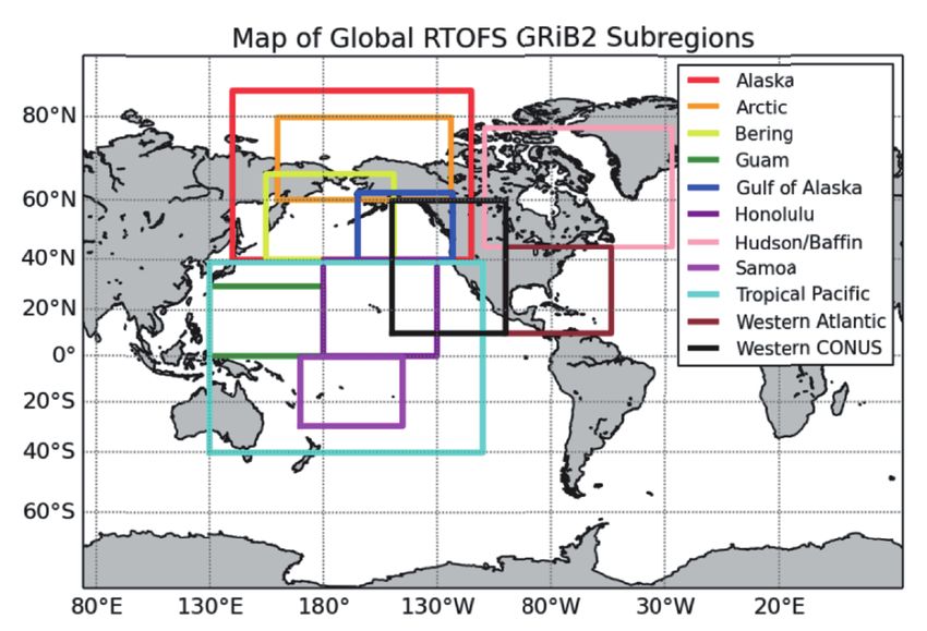
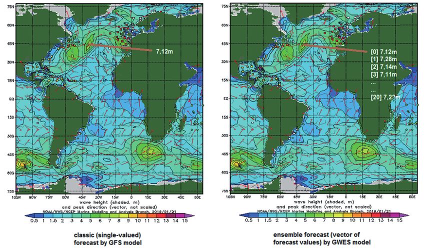
Fig. 1. Illustrative comparison of a single forecast (source: NOAA GFS model data) and ensemble forecast (source: NOAA GWES model data) for significant wave
                                                                           height Hs

probable. It is worth noting that so far there is no robust                     situation can be described using a mathematical description
method available for incorporating ensemble forecasts into                      provided with a digital file. NWP models are constantly being
the ship weather routing process. Designing and developing                      developed by significant weather services. This mathematical
such a method will be one of the key challenges in the course                   description of the weather situation can be saved in various
of this project.                                                                digital formats (GRiB1, GRiB2 or netCDF), provided they are
   During the initial phase of the ROUTING project, research                    acceptable to WMO (the World Meteorological Organisation).
on the available weather forecast services, providing forecasts                 The metadata of this digital file contains information on the
of the assumed weather parameters, accuracy and covering                        originating centre defined in accordance with WMO standards.
the area of the expected sea trial of the prototype (North                         Some of the meteorological services are originating
Atlantic) was conducted. The following weather parameters                       centres, meaning that they use their own measurement
are expected to be gathered on the project’s weather server:                    sources to broadcast weather forecasts. There are also
   • wave forecasts:                                                            services that modify existing numerical models, increasing
        • significant wave height (as ensemble forecast),                       their accuracy and resolution. Another important factor is
        • peak wave period,                                                     the range of meteorological services: global (covering the
        • mean wave direction;                                                  entire world) and local ones. It is worth emphasising that
   • wind forecasts: U- and V- speed components;                                local description usually presents the weather situation using
   • ocean currents: U- and V- speed components.                                numerical models with a denser description grid, thus offering
   The next sections provide details on the available weather                   higher accuracy. Some of the weather services specialise in
services and their suitability for the needs of the ROUTING                     offering various meteorological and hydrological products.
project.                                                                        These products can be extracted as forecasts, archive data
                                                                                and current data. Forecasts can be of varying duration, with
                                                                                different transmission and updating frequencies. They are
      OVERVIEW OF WEATHER SERVICES                                              usually created in a deterministic fashion (one forecast value
                                                                                to describe the meteorological situation at a given point in
   Meteorological services deal with archiving, but also                        space and time), although ensemble forecasts are becoming
the analysis of received meteorological measurements. The                       increasingly popular. As an illustration between the classic and
services can provide various hydro-meteorological data and                      ensemble approach, a comparison of a single-valued (classic)
forecasts, with wind, sea waves and sea currents, among                         forecast by the NOAA GFS model and an ensemble approach
others. The main task of the services includes creating and                     by the NOAA GWES model for significant wave height (Hs)
disseminating forecasts or reports on the current state of the                  forecasts is provided in Fig. 1.
meteorological situation in a commercial or non-profit way.
Some meteorological services use their own data sourced from
measuring buoys and stations or from satellite images, while
others use external data sources. The weather forecasting
process nowadays is realised based on numerical weather
prediction (NWP) models. With this approach, the weather

 82           POLISH MARITIME RESEARCH, No 4/2019
WEATHER FORECASTS FOR SHIP the role it plays in the World Meteorological Organisation and
ROUTING what type of meteorological data is available.
The meteorological services disseminate the necessary
weather information for many sectors of the economy to THE NATIONAL OCEANIC AND
carry out specialised tasks. In this paper we will discuss ATMOSPHERIC ADMINISTRATION
weather services that disseminate information about current (NOAA), HTTP://POLAR.NCEP.NOAA.GOV/
and forecasted meteorological conditions needed in shipping,
with a focus on ship routing. Ship routing and monitoring is NOAA is an agency, under the US Department of
carried out on the basis of ships’ manoeuvring data and sea Commerce, involved in daily weather forecasts, severe storm
conditions. In this case, it is assumed that the sea conditions warnings, and climate monitoring for fisheries management,
are determined by the parameters of wind (speed and direction coastal restoration and supporting marine commerce. The
given directly or via U- and V- components of speed), wave National Centers for Environmental Prediction (NCEP)
(period, height and direction) and sea currents (speed and within NOAA are responsible for providing weather,
direction given directly or via U- and V- components of speed). hydrologic and climate forecasts. This service belongs to
What is more, the wave parameters such as significant wave WMO, officially identified there under the number 7. NCEP
height can be determined based on the ensemble approach. The contains nine distinct centres, which are characterised by a
research area covered here (for the purpose of the ROUTING large variety of services and products. There are special sub-
project) is limited to the North Atlantic. centres specialising in predicting meteorological conditions
The factors taken into account when selecting a particular for the sea (Ocean Prediction Center and the Aviation Weather
weather service include: Center), but also in space (Space Weather Prediction Center).
• geographical coverage, The Storm Prediction Center (SPS) and Tropical Hurricane
• availability of particular hydro-meteorological data Resort in Miami, Florida (NHPC) predict meteorological
(wind, waves, sea currents) for the considered basin threats such as tornadoes, strong storms, lightning and fires.
(North Atlantic), The Environmental Modeling Center (EMC) develops and
• data access costs (where applicable), improves numerical weather, climate, hydrological and ocean
• resolution of data occurrence, prediction. This centre operates and maintains more than
• length and frequency of issuing forecasts, 20 numerical prediction systems, including GFS, GEFS,
• data formats, SREF and CFS. The Central Operations NCEP manages the
• origin of the provided data, and, flow of data and meteorological products in the organisation.
• the experience and overall esteem of a meteorological This centre is responsible for preparing NCEP products for
service. dissemination. Products include traditional deterministic
The aforementioned factors were noted on the basis of forecasts, as well as ensemble forecasts. The models of
available information on the websites and metadata of the particular interest in this service include: GFS, Multi-grid
forecast description files (GRiB2) of selected weather services. Wave, GWES and RTFOS model. All data sources are
Below we list the characteristics of a few selected weather produced by NOAA. The file format is GRiB2 except for the
services, including the organisation, its structure experience, currents data, which is stored in netCDF format.
Tab. 1. The National Oceanic and Atmospheric Adminsitration (NOAA), http://polar.ncep.noaa.gov/
Model Data type Resolution Forecast runs Forecast time step / Forecast Area
interval length
GFS wind 0.25° x 0.25 4 times a day: 1h /THE EUROPEAN CENTRE FOR MEDIUM- EU COPERNICUS, HTTP://MARINE.
RANGE WEATHER FORECASTS (ECMWF), COPERNICUS.EU/SERVICES-PORTFOLIO/
HTTPS://WWW.ECMWF.INT/EN/FORECASTS ACCESS-TO-PRODUCTS/
ECMWF is an organisation that coordinates two services Copernicus is the European Union’s Earth Observation
from the EU’s Copernicus Earth observation programme: the Programme based on satellite Earth observation (6 satellites).
Copernicus Atmosphere Monitoring Service (CAMS) and the The organisation includes, among others, a marine service that
Copernicus Climate Change Service (C3S). ECMWF belongs provides its own archive and prediction of marine data. The
to WMO, where it is identified with the number 98. ECMWF marine service includes two different types of centres. The first
is based in Reading, UK, has 22 Member States and 12 one – Thematic Data Assembly Centres, collect marine data
Tab. 2. The European Centre for Medium-Range Weather Forecasts using satellite and in situ observations in real time. The second
(ECMWF), https://www.ecmwf.int/en/forecasts one – Monitoring and Forecasting Centres (MFC), generate
reanalyses (20 years back), analyses (current) and 10-day
forecasts of the ocean. The Copernicus Programme receives
time step /
Data type
Resolution
Forecast
Forecast
Forecast
interval
data, products and support services from EUMETSAT.
Model
length
Area
runs
EUMETSAT manages the EU space segment and belongs to
the originating centre WMO list, where it is listed as number
0.125° x 4 times 240h Global 254. There is free access to all services using own source data.
6h / 144h - 240h
3h / 90h - 144h
0.125° a day
Data is stored in netCDF format.
1h /called ICON. DWD is one of only fourteen weather services ATMOSPHERIC MODELING AND
in the world running a global numerical weather prediction WEATHER FORECASTING GROUP -
(NWP) model. DWD belongs to COSMO (the Consortium AM&WFG (NATIONAL & KAPODISTRIAN
for Small-scale Modelling). Its general goal is to develop,
improve and maintain a non-hydrostatic limited-area weather UNIVERSITY OF ATHENS), HTTP://
data model, called COSMO. DWD marine services produce FORECAST.UOA.GR/WAMINFO.PHP
both deterministic and probabilistic ocean data predictions.
There is free access to all services using its own source data. A group of scientists from the Kapodistrian University of
Data is stored in GRiB2 format. Athens have been operating for 25 years on the development
of their own models of weather description. This service
mainly provides forecasts for the Mediterranean Sea. The
JAPANESE METEOROLOGICAL AGENCY, meteorological service participates in the creation of numerical
HTTPS://WWW.JMA.GO.JP model predictions: SKIRON and RAMS, based on the data
received from NCEP. There is free access to all services using
The Japanese Meteorological Agency is the national NOAA source data. Data is stored in GRiB2 format.
weather service of Japan. It includes the Meteorological
Research Institute, Meteorological Satellite Center,
Aerological Observatory, Kakioka Magnetic Observatory, and THEYR PRECISION WEATHER PLANNER,
Meteorological College. It belongs to WMO under number HTTPS://WWW.THEYR.COM/INDEX.ASP
34. This service produces and disseminates meteorological
deterministic and ensemble forecast data. It develops its own This company is responsible for the commercial delivery
numerical weather prediction models, as follows: GSM, MSM, of high-precision weather and ocean forecasts. It produces
LFM and GEPS. This service mainly distributes meteorological its forecasts using the WRF system model using NOAA data.
products for Asia. There is free access to all services using its There is payable access to all services using NOAA source
own source data. Data is stored in GRiB2 format. data. Data is stored in GRiB2 format.
Tab. 5. Japanese Meteorological Agency, https://www.jma.go.jp
Model Data type Resolution Forecast runs Forecast time step / intrval Forecast length Area
3 times a day
wind, 0.1875 x
GSM 0000, 0600, - 134h Global
waves 0.1875
1800 UTC
waves (ensemble: 0.5625 x 2 times a day 34 days
GEPS Twice a week /METEO CONSULT, HTTPS://MARINE. When selecting the appropriate weather service for
METEOCONSULT.CO.UK/ the purposes of the ROUTING project, the content of the
abovementioned tables was verified in the context of the
The METEO CONSULT service disseminates credibility of the organisation and the usefulness of specific
meteorological data using NOAA data sources. It is a private data sources. In addition, the ease of access to individual data
company providing services in forecasting the weather for sources was verified. After the analysis, the following choices
the maritime sector. There is mostly free access to all services have been made.
using NOAA source data. Data is stored in GRiB2 format. • Wind: GFS model from NOAA,
• Waves: from NOAA sources
• mean wave direction and wave period between
EXPEDITION 10, HTTP://WWW. peaks from the Multi-grid Wave model,
EXPEDITIONMARINE.COM/EGRIB.HTML • ensemble forecast significant wave height from
the GWES model,
This organisation offers tactical and navigation software, • Sea currents: Real Time Ocean Forecast System from
which is dedicated to well-known regattas. Expedition has NOAA.
been in development since the mid-1990s by veteran Volvo It must be mentioned here that, when it comes to data
Ocean Race navigator and Whitbread winner Nick White. It sources on ocean currents, some services offer historical
offers WRF weather models mainly for the Australian coast. archive data instead of forecasts. One such archive-based
There is free access to all services using NOAA source data. source is Ocean Surface Current Analysis Real-time (OSCAR),
Data is stored in GRiB2 format. developed by NASA. In practice, such data is useful for
estimating seasonal changes of sea currents, but it might not
be sufficient as a source for weather routing (where accurate
THE TIDETECH GROUP, HTTPS:// long-term forecasts are needed) or for collision avoidance
TIDETECHMARINEDATA.COM/ (where up-to-date data or short-term forecasts are necessary).
This is a private weather service, which disseminates data
from NOAA and Copernicus, but also disseminates sources of SELECTED WEATHER DATA MODELS
the Sri Lankan meteorological centre (http://www.meteo.slt.
lk), centre 131 of WMO. This service provides free access in The selected weather data models (GFS, Multi-grid Wave
a demo version and full functionality as commercial services. and GWES from NOAA) are presented in detail in the
All of its services use NOAA source data. Data is stored in following sub-sections.
GRiB2 format.
Tab. 8. Meteo Consult, https://marine.meteoconsult.co.uk/
Forecast time step / Forecast
Model Data type Resolution Forecast runs Area
intrval length
Local: Europe
GFS wind 4km x 4km - - -
Tab. 9. Expedition 10, http://www.expeditionmarine.com/egrib.html
Model Data type Resolution Forecast runs Forecast time step / intrval Forecast length Area
1h /THE GFS MODEL FROM NOAA multi_1.RRRRMMDD, where RRRR is the year, MM
is the month, DD is the day of the forecast issue.
The GFS model provides wind data and is available on the • There are many GRiB2 files in the folder of this model,
Nomads server (administrated by NOAA), under the access including files for local areas.
link: • GR i B2 f iles of the Mult i-g r id Wave
http://nomads.ncep.noaa.gov/pub/data/nccf/com/gfs/prod/. model for global coverage are marked as
The data provided there are organised as follows: Multi_1.glo_30m.tHHz.FFF.grib2, where HH is the
• In the a b ove lo c a t io n , there are time of the weather forecast issue, and FFF is the
folders named according to the r ule: forecast for FFF - the hour of the forecast calculated
gfs.YYYYMMDDHH, where YYYY is the year, MM from the HH release forecast.
is the month, DD day, HH hour of the forecast issue. • The height of the significant wave in the above GRiB2
• In the selected folder, the GFS model files for the given file is marked in the full version (long name) as
date and time are named according to the following “Significant height of combined wind waves and swell&
rule: Gfs.tHHz.pgrb2.0p25.FFF, where HH is the time Ground or water surface”, and in the abbreviation
of the weather forecast issue, and FFF is the forecast for “HTSGW”. The given HTSGW is expressed in meters
the FFF’s forecast hour counted from the HH release [m].
forecast. • The wave period between the peaks is named in the
• In the selected file, wind parameters are defined by full version (long name) “Primary wave mean period
U- and V- components. The U- component is defined & Ground or water surface”, with the abbreviation
by the ugrd10m variable, and the V- component by the “PERPW”. The value of the data is expressed in
vgrd10m variable. seconds [s].
• The mean wave direction is named in the full
THE GWES MODEL FROM NOAA version (long name “Primary wave direction” or
“abbreviation”), the value of the data is expressed in
The GWES model provides the significant wave height as one degrees, where 0° means the movement towards the
main control forecast and 20 equally probable accompanying real north, 90° towards the east, and 180° towards the
forecasts – various variants of the control forecast. south (according to oceanographic convention).
The model is available on the Nomads server, under the
access link: http://nomads.ncep.noaa.gov:9090/pub/data/ REAL TIME OCEAN FORECAST SYSTEM FROM NOAA
nccf/com/wave/prod/. The data provided there are organised
as follows: The model is offered by NOAA / NCEP and provides,
• GWES is located in folders named according to the among others, forecasts of sea currents. Forecasts are available
rule: gwes.RRRRMMDD, where YYYY is the year, in netCDF and GRiB2 file formats, though the latter covers
MM is the month, DD is the day of issue of the GWES only selected areas, mainly the Pacific (Fig. 2), so the netCDF
model forecast set. files are recommended for worldwide applications, including
• There are 84 GRiB2 files in the GWES model folder, transatlantic weather routing.
as well as other files in different formats. The GWES RTOFS data (including global netCDF files) are available
GRiB2 files are marked as follows: gwesPP.glo_30m. under the link:
tHHz.grib2, where PP is the sequence number in the http://nomads.ncep.noaa.gov:9090/pub/data/nccf/com/rtofs/
given set of projections (00 to 20), HH the time of the prod/.
edition of the forecast data set. The above location contains folders named according to
• In the selected files, the significant wave height is the rtofs.YYYYMMDD convention, where YYYY is the year,
defined by the HTSGW variable. MM is the month and DD is the day of the forecast issue.
netCDF (*.nc) files in those folders are named according to
MULTI-GRID WAVE MODEL FROM NOAA the rule: rtofs_glo_2ds_XNNN_PERIOD_MODE.nc, where
X equals ‘f’ (forecast) or ‘n’ (nowcast – a short-term forecast),
The Multi-grid Wave model provides the data on: NNN is the time in hours that the forecast covers, UPDATE
• significant wave height, indicates how often the forecast is issued: (“daily”, “3hrly” or
• wave period between the peaks, “1hrly”), MODE means a forecast done for either diagnostic
• mean wave direction. (“diag”) or prognostic (“prog”) variables.
The model is available on the Nomads server, under the In the case of weather routing, the recommended files are:
access link: http://nomads.ncep.noaa.gov:9090/pub/data/ rtofs_glo_2ds_fNNN_daily_prog.nc (NNN: 000, 024,
nccf/com/wave/prod/. The data provided there are organised 048 and 072).
as follows:
• The Multi-grid Wave model is located
in folders named according to the rule:
POLISH MARITIME RESEARCH, No 4/2019 87SUMMARY AND CONCLUSIONS
As has been shown in the paper, the multitude
of weather data services might actually be
misleading. When it comes to the detailed needs
(here: for the purpose of weather routing in the
North Atlantic), it turns out that the majority
of available sources are lacking area coverage,
update frequency, resolution or completeness. In
the paper a number of weather data services have
been presented and the ones that are optimal for
the specified needs have been chosen. Following
this, their functionality, as well as data access
and data formats, has been researched and the
results are provided in the current paper. While
this review has been prepared with oceanic ship
routing in mind, hopefully it will also be useful for
a number of other applications, including collision
avoidance.
Fig. 2. Geographical regions covered by GRiB2 files of Real Time Ocean
Forecast System (image taken from: https://polar.ncep.noaa.gov/global/about/ ACKNOWLEDGEMENTS
grib_description.shtml).
This research was supported by The National Centre
The files contain, among others, the velocity of a sea current for Research and Development in Poland under the
given by the parameters “u_velocity” (velocity towards east) grant on the ROUTING research project (MARTERA-1/
and “v_velocity” (velocity towards north). ROUTING/3/2018) in the ERA-NET COFUND MarTERA-1
It is worth noting that the grid (4500 x 3298 points) in the programme (2018-2021).
RTOFS global model files has an Arctic bi-polar patch (above
47°N) and a Mercator projection between 47°N and 78.6°S,
as presented in Fig. 3. REFERENCES
1. Acanfora M., Montewka J., Hinz T.,
Matusiak J. (2017): Towards realistic estimation
of ship excessive motions in heavy weather. A
case study of a containership in the Pacific Ocean.
Ocean Eng., Vol. 138, 140–150.
2. Bijlsma S. J. (2008): Minimal Time Route
Computation for Ships with Pre-Specified Voyage
Fuel Consumption. J. Navig., Vol. 61, 723–733.
3. Chang Y., Tseng R., Chen G., Chu P. C.
(2013): Ship Routing Utilizing Strong Ocean
Currents. J. Navig., Vol. 66, 825–835.
4. Chen C., Shiotani S., Sasa K. (2013):
Numerical ship navigation based on weather and
ocean simulation. Ocean Eng., Vol. 69, 44–53.
5. Chen H. (2013): Weather routing versus
Fig. 3. Grid of the global Real Time Ocean Forecast System (image taken from: voyage optimisation. Digit. Sh., 26–27.
https://polar.ncep.noaa.gov/global/about/images/large/pic1.png).
6. Decò A., Frangopol D. M. (2015): Real-time risk of ship
structures integrating structural health monitoring data:
Application to multi-objective optimal ship routing. Ocean
Eng., Vol. 96, 312–329.
88 POLISH MARITIME RESEARCH, No 4/20197. Hagiwara H., Spaans J. A. (1987): Practical Weather Routing 21. Szlapczynska J. (2015): Multi-objective weather routing
of Sail-assisted Motor Vessels. J. Navig., Vol. 40, 96–119. with customised criteria and constraints. J. Navig., Vol. 68.
8. Hinnenthal J., Clauss G. (2010): Robust Pareto-optimum 22. Szlapczynski R., Krata P. (2018): Determining and
routing of ships utilising deterministic and ensemble visualizing safe motion parameters of a ship navigating in
weather forecasts. Ships Offshore Struct., Vol. 5, 105–114. severe weather conditions. Ocean Eng., Vol. 158, 263–274.
9. James R.W. (1957): Application of wave forecast to marine 23. Tagliaferri F., Viola I. M. (2017): A real-time strategy-
navigation. US Naval Oceanographic Office, Washington. decision program for sailing yacht races. Ocean Eng., Vol.
134, 129-139.
10. Krata P., Szlapczynska J. (2018): Ship weather routing
optimization with dynamic constraints based on reliable 24. Tsou M.-C. (2010): Integration of a Geographic Information
synchronous roll prediction. Ocean Eng., Vol. 150, 124–137. System and Evolutionary Computation for Automatic
Routing in Coastal Navigation. J. Navig., Vol. 63, 323–341.
11. Mannarini G., Coppini G., Oddo P., Pinardi N. (2013): A
Prototype of Ship Routing Decision Support System for 25. Vettor R., Guedes Soares C. (2015): Multi-objective Route
an Operational Oceanographic Service. TransNav, Int. J. Optimization for Onboard Decision Support System.
Mar. Navig. Saf. Sea Transp., Vol. 7, 53–59. 99–106.
12. Mannarini G., Pinardi N., Coppini G., Oddo P., Iafrati 26. Vettor R., Guedes Soares C. (2017): Characterisation of the
A., Nazionale I., Creti V. D. (2016): VISIR-I : small vessels expected weather conditions in the main European coastal
– least-time nautical routes using wave forecasts. Geosci. traffic routes. Ocean Eng., Vol. 140, 244–257.
Model Dev., Vol. 9, 1597–1625.
27. Vettor R., Soares C. G., Wo Y. (2017): Assessment of the
13. Marie S., Courteille E. (2013): Multi-Objective Optimization Storm Avoidance Effect on the Wave Climate along the
of Motor Vessel Route. Int. J. Mar. Navig. Saf. Seas Transp., Main North Atlantic Routes. J. Navig., Vol. 69, 127–144.
Vol. 3, 133–141.
28. Wei S., Zhou P. (2012): Development of a 3D Dynamic
14. Motte R. H., Calvert S. (1990): On The Selection of Discrete Programming Method for Weather Routing. Int. J. Mar.
Grid Systems for On-Board Micro-based Weather Routeing. Navig. Saf. Sea Transp., Vol. 6, 79–85.
J. Navig., Vol. 43, 104–117.
29. de Wit C. (1990): Proposal for Low Cost Ocean Weather
15. Natskår A., Moan T., Alvær P. O. (2015): Uncertainty in Routeing. J. Navig., Vol. 43, 428–439.
forecasted environmental conditions for reliability analyses
of marine operations. Ocean Eng., Vol. 108, 636–647. 30. Życzkowski M., Krata P., Szłapczyński R. (2018): Multi-
objective weather routing of sailboats considering wave
16. Perera L. P., Soares C. G. (2017): Weather routing and safe resistance. Polish Marit. Res., Vol. 25, 4–12.
ship handling in the future of shipping. Ocean Eng., Vol.
130, 684–695. 31. Zyczkowski M., Szłapczyński R. (2017): Multi-Objective
Weather Routing of Sailing Vessels. Polish Marit. Res.,
17. Roulston M. S., Ellepola, J., von Hardenberg J., Smith Vol. 24.
L. A. (2005): Forecasting wave height probabilities with
numerical weather prediction models. Ocean Eng., Vol. 32. ROUTING project web-page, (n.d.).
32, 1841–1863.
18. Specht C., Rudnicki J. (2016): A Method for the Assessing
of Reliability Characteristics Relevant to an Assumed
Position-Fixing Accuracy in Navigational Positioning
Systems. Polish Marit. Res., Vol. 23, 20–27. CONTACT WITH THE AUTHORS
19. Suzuki R., Tsukada Y., Tsujimoto M., Muraoka E., Ueno M. Marcin Życzkowski
(2017): A study on high-lift rudder performance in adverse e-mail: marzyczk@pg.edu.pl
weather based on model tests under high propeller load. Gdańsk University of Technology
Ocean Eng., Vol. 136, 152–167. Narutowicza 11/12, 80-233 Gdańsk
Poland
20. Szlapczynska J. (2007): Multiobjective Approach to Weather
Routing. TransNav - Int. J. Mar. Navig. Saf. Sea Transp.,
Vol. 1, 273–278.
POLISH MARITIME RESEARCH, No 4/2019 89You can also read