How Meteodrones Contribute to Weather Forecasting - White Paper, March 2020
←
→
Page content transcription
If your browser does not render page correctly, please read the page content below

1

White Paper, March 2020

How Meteodrones
Contribute to
Weather Forecasting
2
Executive Summary
This white paper describes the observational data challenges that impact modern numerical weather
forecasts and how these could be overcome with unmanned aerial vehicles (UAV). Small rotary wings
UAV have the potential to provide a unique observing system capable of measuring detailed vertical
profiles of temperature, humidity, air pressure and wind. These meteorological data - captured within
the planetary boundary layer (PBL) - help to determine the potential for severe weather formation and
enhance the forecasting ability for atmospheric conditions such as hail, icing and fog formation among
others.

Table of Content
Executive Summary ................................................................................................................................ 2

Computation of a Numerical Weather Forecast ...................................................................................... 3

Meteodrone Systems .............................................................................................................................. 4

Meteorological Data ................................................................................................................................ 6

Using UAV data in Numerical Weather Forecasting ............................................................................... 9

Case Studies ........................................................................................................................................ 10

Meteobase – a remote platform ............................................................................................................ 12

What is next? ........................................................................................................................................ 13

Company Background .......................................................................................................................... 13

3
Computation of a Numerical Weather Forecast
Mathematically modern weather forecasts are for-                    be retrieved after descending. Moreover, highly
mulated as an initial value problem. Or in other                    sensitive and accurate measurement devices at-
words, knowing the current weather conditions al-                   tached to the balloons increase the costs of their
lows to abstract a future weather state. Typically,                 operational use. Therefore, balloon soundings
a future state is derived by applying physical laws,                are carried out only twice a day and only at se-
like coupled thermo-dynamical and Navier-Stokes                     lected locations.
equations. Unfortunately, this practice suffers from
two downsides:                                                      As a consequence, weather phenomena like fog,
                                                                    low stratus and storms cannot properly be pre-
(i) There are no analytical solutions known to the                  dicted as they are triggered in the PBL.
Navier-Stokes equations. A solution up to a certain
degree of resolution can only be found by using                     A number of different attempts have been made
numerical approximation.                                            to overcome this issue collecting more reliable
(ii) The description of the initial (current) state of              data. Remote sensing techniques – either satel-
the atmosphere lacks sufficiently accurate infor-                   lite-borne, airborne or ground based – have been
mation.                                                             designed over the last 20 to 30 years. These re-
                                                                    mote sensing techniques usually make use of la-
In the last 10 years the computational capacity for                 ser (e.g. LIDAR), active or passive microwave
running global weather models in a resolution of                    (e.g. radiometer) or different types of radar de-
10 km or locally even less (1 km) has become                        vices. All of these measurement methods share
more easily available and more affordable. Con-                     the following downsides:
sequently, facing problem (i) is still challenging but
manageable.                                                         •    relatively expensive
                                                                    •    limited mobility
Regarding (ii) major advances have been made                        •    designed for one specific use case/ physi-
thanks to satellite data that have been assimi-                          cal parameter
lated into global models. However, a closer look                    •    no data in adverse condition
at the different data sources reveals a gap in the
planetary boundary layer (PBL), i.e. the first 1 to                 Small unmanned aerial vehicles (UAV) do not
2 km above ground level (AGL). Even though                          suffer from these issues. Therefore, they can im-
weather phenomena forming in this layer directly                    prove the information gathered in the PBL by di-
affect us, actual measurements of meteorologi-                      rectly and accurately measuring prognostic vari-
cal parameters are scarce. A popular solution for                   ables. As UAVs are not lost during soundings,
the last 100 years were balloon soundings that                      several atmospheric profiles can be flown in one
collect and deliver readings of different weather                   session or even during a longer time period.
parameters. Unfortunately, these balloons are                       Hence, a temporal evolution of the measured pa-
usually lost after deployment as they are carried                   rameters can be observed.
away with the wind. Moreover, their landing spot
is often not easily accessible; thus, they cannot

                         1’000 km       SATELLITE

                          100 km

                                                 AIRCRAFT               RADAR

                          10 km

                                                                PBL UP TO 2 KM
                           1 km        WEATHER
                                                                LIMITED DATA
                                       BALLOON
                                                                TRIGGER FOR STORMS           METEODRONE
                                                                LOW STRATUS
                          100 m                                 FOG

                                       WEATHER              LASER                SOUND/
                           10 m        STATION                                   MICROWAVE

                        Figure 1: Meteodrone closes the data gap.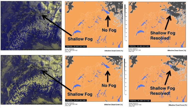
4
Meteodrone Systems
Meteomatics developed three different systems with different characteristics and advantages for us-
ages. In the following, these three systems are described in more detail.
All systems are equipped with a ground station and a transport case. The ground station receives real-
time telemetry data (incl. meteorological data). The case is IP65 rugged for transport and includes the
ground station charger, tools, spare batteries, etc.
5
A Close-Up of the Meteodrone Classic

                   Component to Stay                        Emergency Rescue
                 in Assigned Airspace                            System

                                                        Wind Measurement Using
                                                           Aircraft Pitch & Roll
                               White Strobe
                             (Visibility > 3 km)

Each UAV is equipped with a ground station that        the ground station where they are stored on an-
enables a redundant telemetry link to the drone.       other SD card. The Meteodrone Classic and the
All flight-relevant parameters are shown in real-      Meteodrone XL are equipped with an emergency
time on a display attached to the ground station       rescue system (ERS) which is a necessity for fly-
ensuring a direct monitoring of the flight. Hence,     ing under BVLOS conditions. The ERS can be
the pilot is able to keep track of the UAV at all      manually triggered from the ground station.
times:
     • Position (moving map)                           All Meteodrones are pre-programmed to perform
                                                       vertical ascents/descents with constant climb
     • Altitude and heading
                                                       rates around 3-10 m/s up to an altitude of 3000 m
     • Power consumption
                                                       AGL. However, custom flight profiles are possible.
     • Current weather
     • Wind conditions                                 It is strongly recommended to ensure with your
The primary radio link uses 2.4 GHz and the sec-       aviation safety authority that the aircrafts are con-
ondary uses either 433 MHz, 900 MHz (USA) or a         sidered to be airworthy. Moreover, the air traffic
frequency according to local regulations. The          control and the operator must inform other air traf-
gathered data is stored on an SD card on the UAV.      fic participants of planned operations, e.g. by issu-
It further transmits the most important variables to   ing NOTAMs, blind calls, restricted airspaces.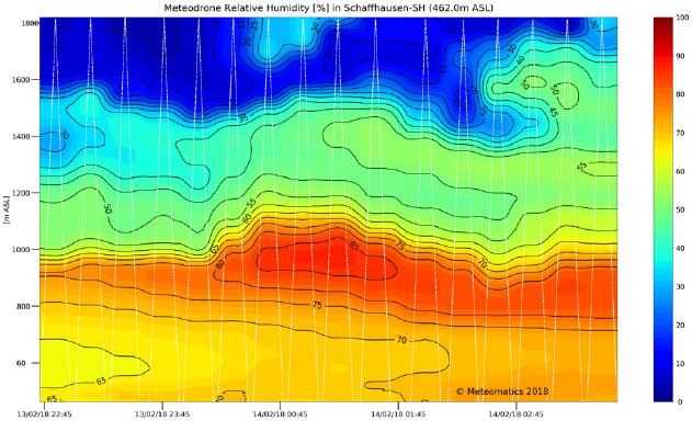
6
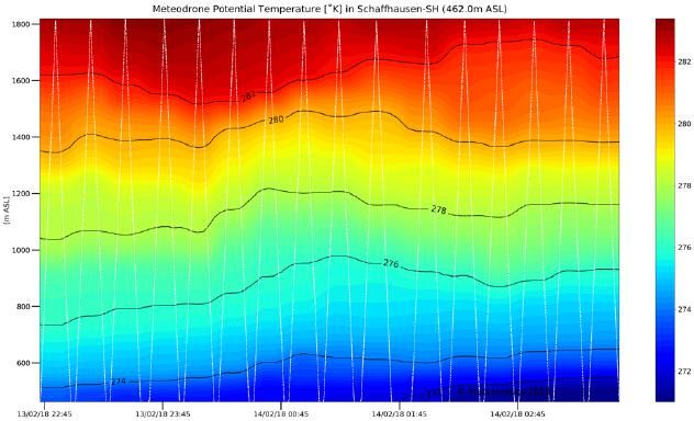
Meteorological Data
The raw meteorological data is sampled with 4 Hz raw data is post-processed online. This includes
and transmitted to the ground station. In addition, also the transformation into a RAOB format to dis-
the data is stored on an on-board SD-card. After play soundings. Sequences of flights can be visu-
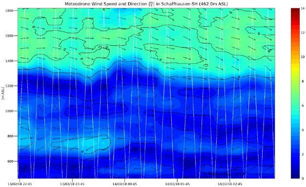
landing the data can be accessed via Wi-Fi. The alized online with charts such as following:
Wind Speed & Direction
Pressure
Potential Temperature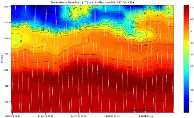
Relative Humidity   Dew Point Temperature   Temperature
                                                          7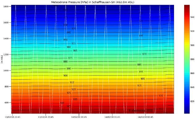
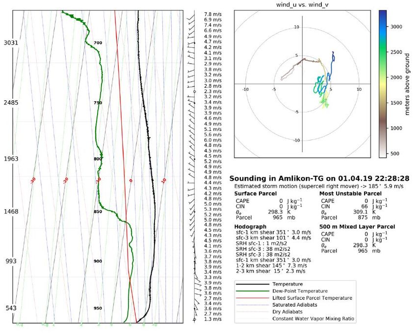
8
Single flights can also be visualized in a skew-T
log-P diagram (s. figure 2)

Figure 2: Skew-T log-P diagram including a hodograph
9
Using UAV data in Numerical Weather Forecasting
Assimilation into WRF
Once the data from the Meteodrone have been ac-         4d-nudging or 4d-VAR routines can also be used
quired, they can be straightforwardly ingested into     to assimilate the drone data into the initial state of
mesoscale models such as MM5 and WRF with-              the weather model.
out implementing any additional forward observa-
tional operators. Therefore, we use a data format       In order to estimate meteorological parameters at
recognized by WRF which allows for the “recy-           higher altitudes the atmospheric lapse rate is tra-
cling” of all existing data assimilation routines for   ditionally calculated using weather station data.
balloon soundings.                                      However, these calculations are prone to errors.
                                                        The Meteodrone data enable the measurement of
Depending on the topography and the height of           the actual lapse rate which can then be applied to
the mission, the radius of influence of the Mete-       other regions as well.
odrone gathered data can be 15 to 45 km. Existing

Figure 3: SWISS1k workflow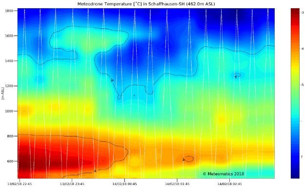
10
Case Studies
Fog Formation
The following shows an example comparing the             locations at the southern west-east axis of the lake
occurrence of early morning fog and low stratus          (Schaffhausen, Amlikon and Marbach) - were as-
between model runs with and without Meteodrone           similated. In column b the WRF run is shown with-
data being assimilated into the WRF model.               out any drone data. Column c shows how the
                                                         moisture recorded by the drone flights has been
Column a in Fig. 4 shows the satellite cloud cover       picked up by the model: Fog and low stratus were
for 7 AM (upper image) and 8 AM (lower image).           detected and resolved in the early morning.
The columns b and c in Fig. 4 represent the
SWISS1k model forecasts for these two dates. Of          An additional observation is the model’s inability to
special interest here is the area of Lake Constance      pick up the shallow fog on the western Swiss plat-
(North-Eastern Switzerland) which is covered by          eau and in northern Italy. In these areas, no sup-
fog and low stratus. In this particular case, the data   porting Meteodrone data was gathered to help to
of three Meteodrone systems - flown at three             correct moisture profile.
           a)                                  b)                      c)

          Figure 4: a) Satellite cloud cover during the event, b) SWISS1k forecasts without Mete-
          odrone data, c) SWISS1k forecasts with Meteodrone data

Storm Formation
Depending on the stability of the atmosphere,            – all cities close to Lake Constance. In comparison
topographically induced storms can be observed           to the right, the operational models, without any
within Alpine regions. Such an event happened on         additional drone data, such as ECMWF, NCEP
the 29th May 2017.                                       and Met Office, were not able to capture the se-
                                                         vere storms that formed in the late evening. The
The image on the upper left-hand side shows the          lower left picture shows the radar image data
precipitation rendered from the model with Mete-         measured at that time.
odrone data. The red dots indicate flight profiles
with their effective radius of impact (red dashed
line) taken in Schaffhausen, Amlikon and Marbach
11
a) b)
c) d)
Figure 5: a) Precipitation in the model forecast with Meteodrone, b) Precipitation in
the model forecast without Meteodrone, c) Difference between models with and
without Meteodrones, d) Radar image of precipitation during the event
Icing Conditions
Icing does not only pose a problem to passenger • Air temperature < 0 °C
aviation and helicopters but to UAVs as well. The • Relative humidity > 95 %
ice accumulations cause a loss of controllability.
Since more UAVs are used in everyday life the risk Drone enhanced forecasts of temperature, relative
to the public is increasing. humidity and wind speed allow for identifying icing
conditions (red area in figure 6).
Two conditions have to prevail in order to cause
ice accumulations on propellers:
Figure 6: Drone weather by Meteomatics: Vertical profile of tempera-
ture, relative humidity and wind12
In this project test-flights in real icing-conditions icing on the Meteodrones was examined and dif-
were conducted. Moreover, icing in different envi- ferent anti-icing methods were analyzed. A relia-
ronments was tested: outdoors during winter, in an ble heating method for the propellers is shown in
indoor ski slope and in the Vienna Climatic Wind the following image.
Tunnel (VCWT). Based on these tests the effect of
Figure 7: Extreme accumulation of clear ice amount (left) and heating of propellers (right).
Meteobase – a remote platform
An important step towards nationwide drone oper- • controlling of climatization of the Meteobase,
ations has been the development of the Mete- monitoring of optional camera footage and
obase. As a ground station, it allows the on-site weather parameter at ground station site,
support of Meteodrones. The ground station • logging of relevant data.
serves as a communication element between the The Meteobase comprises the complete start- and
control center and the UAV. It consists of a central landing platform, including a recharging unit, the
computer that controls and directs radio link and ground station, and cameras for sur-
veilling the direct surrounding of the box. The cam-
• communication of telemetry data from the eras allow for verifying that the UAV has landed
Meteobase to the UAV via the serial down- correctly and for visually checking the UAV’s gen-
link and a 4G redundant internet connection eral condition.
for the Meteobase to the operation control
center, In addition, it incorporates an internal climatization
• initiation of the opening and closing of the (heating, air conditioning) to ensure optimal cli-
Meteobase lids before and after take-off and matic conditions for the UAV, its electrical compo-
landing, nents and the batteries. The base is water- and
• initiation of recharging of the UAV after mis- snow proof, with rain gutters ensuring the smooth
sion completion, discharge of rainwater. It is a fixed installation:
Once it is deployed, it will stay at the operational
site for the time of the operation.
Figure 8: Meteobase deployed at Illgraben.13
What is next?
• Targeting altitudes of 5’000 m to 8’000 m AMSL
• Tackling higher operational wind speed
• Internationalization of display units (selectable)
• Provision of additional output formats such as WMO TEMP, WMO TEMP MOBIL, WMO
PILOT and others
Figure 9: Timeline of flight altitudes of Meteodrones
Company Background
Meteomatics is a leading weather service provider To provide the best data for any coordinate world-
with offices in St. Gallen, Berlin and Exeter and wide, Meteomatics aggregates the latest weather
employees with strong backgrounds in physics, forecast models, satellite data, rainfall radar infor-
mathematics and computer science. Working mation and station observations from a variety of
closely with National Met Services and industry, sources around the planet. To further enhance this
Meteomatics is specialized in commercial high- data Meteomatics also produces its own high-res-
resolution weather forecasting, power output fore- olution atmospheric model at a 1 km resolution
casting for wind, solar and hydro, gathering of across Switzerland. The great forecast skill of
weather data from the lower atmosphere using SWISS1k is only possible due to the data received
Meteodrones and simple delivery of quality from the unique Meteodrone measurements within
weather data via the Weather API. At its heart, Me- the lower atmospheric layers.
teomatics pursues two core values: innovative
technology and improved data quality. By accessing the Weather API our customers’
businesses will be far better positioned to address
Companies have a requirement to better integrate customer, regulatory and wider societal demands
consistent, quality weather data across the whole now and in the future. The API will also drive inno-
business; to empower the various business units vation by making data simply available for internal
to enhance current operational performance and and external teams to deliver big data driven op-
to deliver business insights that drive innovation erational insight
resulting in new and improved services.You can also read