Il Settore spaziale di Copernicus e le infrastrutture nazionali - Roberto Battiston Agenzia Spaziale Italiana - Ispra
←
→
Page content transcription
If your browser does not render page correctly, please read the page content below
Il Settore spaziale di Copernicus e le
       infrastrutture nazionali
             Roberto Battiston
          Agenzia Spaziale Italiana
Copernicus:
                  p         Objectives
                              j
 Objectives
                                       Protect people and
                                       assets

                                   Increase general knowledge on the
                                   state of the Planet

                                          Improve environmental policy
Monitor the environment                                  effectiveness

                                       Facilitate adaptation
                                         to climate change

 Foster downstream applications
           in a number of fields      Help managing emergency and
                                           securityy related situations
Components
              p       & Competences
                           p
                            Coordinators:         Partners:

                                                            Private
                  Space                     Industries    companies
                Component                   National Space
                                              Agencies Eumetsat

                 Services
                                                     Service
                Component                           operators
   Overall
 Programme
Coordination

                  In‐Situ                          National
                Component                       environmental
                                                  agencies

                                                                      3
Copernicus
                 p        Sentinels

S1A/B Radar Mission
S1A/B:                                                   2014/end 2015

S2A/B: High Resolution Optical Mission                   2014/2016

S3A/B: Medium Resolution Imaging and Altimetry Mission   2014/2017

S4A/B: Geostationary Atmospheric Chemistry Mission       2019/2027

S5P: Low Earth Orbit Atmospheric Chemistry Mission       2015

S5A/B/C: Low Earth Orbit Atmospheric Chemistry Mission   2020/2027

Jason‐CS A/B: Altimetry Mission                          2019/2025
Launch Sentinel 1A
• 3 April 2014
• Kourou spaceport
• Soyuz‐2 rocket
• New era of Earth observation
© ASI, 2013Copernicus
p Data Policyy
SSentinel
ti l Data
D t Policy
P li =
FREE and OPEN access
ESA Sentinel Data Policy (Sep 2013) and EU Delegated Act on Copernicus Data
and Information Policy (Dec 2013)
Main principles of Sentinel data policy:
Open access to Sentinel data by anybody and for any use
Free of charge data licenses
Restrictions possible due to technical limitations or for security
reasons….with a long‐term operational perspective
Access to Contributing Missions
S‐1 A/B/C/D
S‐1 A/B 2nd Generation
S‐2 A/B/C/D
S‐2 A/B 2nd Generation
S‐3 A/B/C/D
S 3 A/B 2nd Generation
S‐3
S‐4 A/B (on MTG)
SS‐5
5 Precursor
S‐5 A/B/C (on MetOp‐SG)
S‐6 A/B
7Advantages
g of Sentinel Satellites
Fully
operational
system
Most comprehensive Complementary
EO system in to Contributing
the world Missions
Long‐term
Free Sentinel b ti
observations
data
8Copernicus Contributing Missions
SPOT ((VGT)) COSMO‐Skymed
TerraSAR–X
PROBA‐V Tandem‐X
Radarsat
DMC Copernicus
Contributing
Pléiades Missions Cryosat
Deimos-2
Jason
Atmospheric
A h i
RapidEye missions
SPOT (HRS)
MetOp Meteosat 2nd Generation
9COSMO‐SkyMed Constellation
• Largest Italian Investment in EO
• 4 Satellites, X‐band SAR COSMO-SkyMed
• No other 4 SAR satellites constellation
today on the EO operational scenario
• Fully operative since 2011
• COSMO‐SkyMed highlights:
– Guaranteed Image Acquisitions
(day/night & all weather)
– Multiple imaging modes (variable
resolution)
– Very High Resolution and High quality
images COSMO-1
– Fast
F t response
– Large area collection
– Unmatched revisit
– Worldwide Accessibility
COSMO-4
– Interferometric and polarimetric
capabilities
COSMO-3
COSMO-2Sentinel 1 /COSMO‐SkyMed Synergies Spatial coverage of S1 (left) and CSK (right) acquisitions for the AOI of the Po river in the period 13‐20 November 2014
Sentinel 1 /COSMO‐SkyMed Synergies

 S1A
17/11

                                      CSK 19/11
Ground Segment
g ArchitectureIT Collaborative GS
• Th
The Sentinel
S ti l Collaborative
C ll b ti GroundG d Segment,
S t has
h been
b
introduced by ESA with the aim of further exploiting
the Sentinel missions respectp the Core Ground
Segment functions, offering specialized solutions not
being actually covered by the Core ground segment.
• ASI / ESA SiSignature
t off th
the Italian
It li Collaborative
C ll b ti Ground
G d
Segment Agreement, Octber 6, 2014
• Italian Users Community will benefit the ASI IT‐
Collaborative capabilities (data reception, processing,
archiving and dissemination of S1 / S2 / S3 standard
L 0
Lev 0, 1
1, 2 products
d with
i h NRT / low
l latency
l
performances).IT Collaborative GS
• The Collaborative Ground Segment is a National funded initiative
initiative. It is also
supported by ESA in the framework of GSC‐3 programme.
• It is dedicated to national user community.
• Sentinel Italian user community (institutional,
(institutional scientific and commercial)
expressed their requirements in terms of data, observation needs, area of
interest, priorities…
• It allows the direct take off of Sentinel data and ‐ in a subsidiary way – of
national missions (in Italy: COSMO‐SkyMed).
• Other national centres of competences can join it in the European
p
network and contribute to enrich the Copernicus products
p p
portfolio
through collaborative products and cal/val capabilities.
• It allows to effective grow the services capabilities and the business
opportunities.
• First Functions of the IT Collaborative GS:
• Mirror archive for the italian users areas of interest
• Near Real Time access to Sentinel dataOld ASI missions
(S
(SRTM/..)
/ )
EDRS TLR‐1 / TLR‐3 / TLR‐4 / TLR‐6 / CNM Cosmo / IC‐MAPS
ESA SSentinels
ti l & GCM Cosmo SkyMed
C Sk M d Cosmo SkyMed
C Sk M d ASI‐
ASI
MIAS
Core G/S IC‐UGS TUP
Sentinel NRT/STD Products Cosmo NRT/STD
ASI Sentinel
Products
Collaborative
ll b i Center
ESA MISSIONS
NRT Products LTDP
Sentinel 1/2/3
ASI FRAMEWORK
Acquisition Subsystem
Long Term Archive
Sentinel 1/2/3 Data Preservation
Processing and STD Products
Archivingg Center
ASI ‐ LTDP Access Services Internet
ASI CNM
ASI Mission
Products
DMZ Area
Basic Production
Services Servizi di accesso dati
Rolling Archive NRT Servizi di accesso dat
via WEB
Prodotto 1 QA
Prodotto 2
Prodotto nASI Earth Observation Scenario
Earth Observation capability of ASI
MICROWAVES INFRARED VISIBLE
• COSMO‐SkyMed
SAR MISSIONS
• ORFEO
• SIASGE OPTICAL MISSIONS • ORFEO
• Canadian • PRISMA
MULTIFREQUENCY Cooperation • SHALOM
HYPERSPECTRAL
APPROACH • Japanese
Cooperation MISSION
ASI CENTRE FOR
SPACE GEODESY
© ASI, 2014PRISMA Mission
• Mission Statement:
“… a pre‐operative small Italian hyperspectral mission, aiming to
qualify the technology,
technology contribute to develop applications and provide
products to institutional and scientific users for environmental
observation and risk management …”
• Applicazioni per fenomeni di land degradation e stato di salute della
vegetazione
– Mappe di metriche di paesaggio
– Mappe delle aree erose
– Mappe di degrado del suolo
• Applicazioni in aree agricole
– Stima di variabili biofisiche e biochimiche delle colture agrarie (LAI, FPAR, clorofilla)
– Stima di proprietà agronomiche del suolo da dati iperspettrali satellitari acquisiti
su suolo nudo
– Stima di variabili d'interesse agronomico ed ambientale, legate all'azoto,
mediante assimilazione di dati telerilevati in modelli di funzionamento delle
colture agrariePRISMA: Applicazioni per lo stato di salute della vegetazione
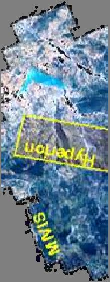
Parco Nazionale del Pollino
MIVISS and Hyperion classification
f maps obtained by applying the Minimum Distance (MD)
( ) method and considering 13 CORINE
CO
classes (up to the 4th level). MIVIS thematic map was spatially re-sampled to the Hyperion resolution.PRISMA: Applicazioni in aree agricole Mappe di contenuto di clorofilla nelle foglie (Cab) ed indice di area fogliare (LAI) Ottenute da telerilevamento con sensore iperspettrale (CASI)
International Coordination

• GEO Global
        Gl b l Forest
               F      Ob
                      Observation
                               i Initiative
                                  I i i i (GFOI)
• GFOI is being developed by GEO, led by: Australia,
  N
  Norway,   th
            the USA,
                USA The
                     Th Food
                         F d and d Agriculture
                                   A i lt
  Organization of the United Nations (FAO), and the
  Committee on Earth Observation Satellites (CEOS).
                                               (CEOS)
• CEOS has committed resources from the world’s space
  agencies to provide a systematic contribution of
  observations to meet the needs of countries
  participating in GFOI.
• ASI, following also request from ISPRA, is involved
  through CEOS in GFOI initiative
International Coordination
• GEO Gl
Global
b lAAgricultural
i lt l Monitoring
M it i (GEOGLAM)
• GEOGLAM is being developed by GEO, with the objective to
reinforce the international community’s capacity to produce and
di
disseminate
i t relevant,
l t timely
ti l andd accurate
t forecasts
f t off agricultural
i lt l
production at national, regional and global scales.
– National capacities for agricultural monitoring
Strengthening capacity building,
Strengthening, building experience sharing,
sharing research.
research
– Global and regional agricultural monitoring systems Harmonizing,
connecting and strengthening of existing systems, inter‐comparing and
disseminating their information.
information
– Global observation system for agricultural monitoring : Developing an
operational system : coordinated satellite and in‐situ Earth
Observation and weather forecastingg
• ASI could support GEOGLAM initiative through CEOS, especially if
there is an interest from italian usersConclusions
• Copernicus has entered its operational phase
• COSMO‐SkyMedy is workingg as a contributingg
mission
• ASI is developing the Italian Collaborative Ground
Segment to serve the Italian User Community
• Dialogue is open between ASI and the Sentinel
Italian user communities to gather their
requirements in terms of data, observation
needs, area of interest, priorities..
pSTRIPMAP PING PONG CSK data for crop mapping
Yanco, Australia
HH
SMAPEx & ASI COSMOLAND campaign
STRIPMAP PING PONG
HH & HV polarization
(spatial resolution 20m,
21° incidence)
100
Overall Classification accuracy
90
11 classes
80
HH
70 HV
HHHV
60
50
40
Multi-temporal CSK RGB: 1 2 3 4 5 6 7 8
R=11/10;; G=11/26;; B=12/12 N r imag es
ASI COSMOLAND Project, final report, 2011Crop classification of multi‐temporal SAR data
CSK data over the Capitanata plain, Italy
O
Overall
ll Cl
Classification
ifi ti accuracy
StripMap HH & HV 5 classes
PING PONG
images 26° inc.
Nr. Date
1 06/04/11
2 14/04/11
3 22/04/11
4 08/05/11
5 01/06/11 The best result (5 classes) is obtained by
6 17/06/11 using 9 HH & HV CSK images (approx. 85%
7 25/06/11
8 03/07/11
in test)
9 11/07/11 ASI COSMOLAND Project, final report, 2011You can also read