Fulcrum3D Sodar | simply better - state of the art remote sensing
←
→
Page content transcription
If your browser does not render page correctly, please read the page content below
Fulcrum3D Sodar | simply better
           state of the art remote sensing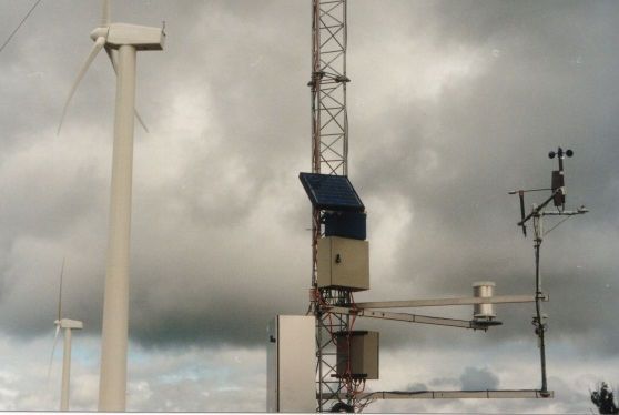
Fulcrum3D Sodar | simply better

reliable, flexible & cost-effective                                a new innovative sodar design
The Fulcrum3D Sodar is a portable wind monitoring unit
designed to measure wind speed, direction and inflow angle
                                                                   compact-beam design
from 40m up to 200m above ground level. Optimised for the          The compact-beam design of the Fulcrum3D Sodar minimises
operating range of modern wind turbines, it is purpose designed    errors introduced where the wind speed vector is not constant
for performance in complex terrain and to meet the stringent       across the beams, such as in highly turbulent or complex terrain.
requirements of the wind energy industry.                          The Fulcrum3D Sodar uses a very narrow beam angle (9°/12°
                                                                   from vertical axis) compared with competing units which
The Fulcrum3D Sodar is delivered complete with its own trailer,
                                                                   typically have beam angles up to 30° from vertical axis.
solar power supply and communications system.
                                                                   The Fulcrum3D Sodar uses physically fixed beam angles rather
Applications include:
                                                                   than electronic beam steering which requires constant
 site prospecting & infill for ‘bankable’ resource assessment     frequency adjustment for local atmospheric conditions. Its
                                                                   broad operating frequency range (3.5 – 7.5 kHz), allows multiple
 verifying wind shear above an existing met mast
                                                                   units to be co-located without interference.
 low cost measurements for noise monitoring campaigns
                                                                   multi-beam sampling
 complementing met masts with additional                 Sodar
  monitoring locations to reduce yield uncertainty                 The three independent beams of the Fulcrum3D Sodar can be
 directly measuring inflow angles to confirm turbine              pulsed simultaneously (“multi-beam sampling”), providing more
  suitability for the site                                         data samples per 10min period and higher data quality and
                                                                   availability, especially at greater heights. Competing designs use
 measuring power performance of operating wind turbines,          a single steered beam which can only be pulsed sequentially,
  e.g. for O&M diagnostics                                         reducing the number of data points available.

Fulcrum3D’s Flightdeck provides a web based data delivery          full spectrum data retrieval for traceability
interface allowing access, download and analysis of data.
                                                                   The Fulcrum3D Sodar records and stores full signal and noise
                                                                   data on the unit and transmits this entire dataset to
proven ‘Stage 2’ performance                                       Fulcrum3D’s secure servers for processing into wind speed data.
                                                                   Competing Sodar designs use on-board processing and only
The Fulcrum3D Sodar has been independently verified in             transmit the calculated wind speed result, meaning the full
different climates, topography, locations and elevations by        spectrum data is lost. This approach allows a consistent and fully
internationally recognised wind energy experts. DNV GL has         traceable dataset to be provided to third parties for verification
deemed the Fulcrum3D Sodar to be ‘Stage 2’ allowing it to be       & analysis. Also, data can be reanalysed using improved or third
used in formal wind energy assessments including bankable          party processing algorithms to maximise data accuracy.
wind energy studies.
                                                                   cold climate option
Correlation coefficients against high quality tall met masts are
typically >0.98 at IEC Class 1 Terrain sites, with slopes          Fulcrum3D has a cold climate Sodar option which is
comparable to cup anemometry in both simple and complex            operationally identical to the standard Sodar. This version
terrain. The Fulcrum3D Sodar has demonstrated higher accuracy      includes snow and ice melt capability on the sound reflector
and availability than its competitors in side by side trials.      plate in cold climates, and can include a modular methanol fuel
                                                                   cell (45 or 110W) with over 6 months fuel storage to last the
                                                                   whole winter to avoid costly refuelling in the coldest months

                                                                            “For anyone requiring a flexible, easily-deployed, and
                                                                        accurate system for wind speed and direction data collection,
                                                                                  I can highly recommend the Fulcrum3D”

SODAR | CLOUD TRACKING | SOLAR FORECASTING | ENVIRONMENTAL MONITORING
key benefits for your projects                                     specifications
low cost, flexible deployment
 significantly lower costs of installation, operation and         design parameters
  removal than met masts and lidar systems
                                                                   Phased array          3 phased arrays each with 37 Piezoelectric
 faster deployment with minimal delays as planning                                      transducers. 100% acoustic fill factor
  approval is generally not required, there is no construction     Number of sound       1 beam per array, 3 beams total
  lead time, and no risk of weather delays                         beams                 Single beam or multi-beam sampling
 lower maintenance costs than met masts which are prone           Sound beam tilt       Physically set at 9° and 12.7° from vertical
  to damage by lightning and birds and require annual                                    Beam tilt independent of frequency and
  maintenance and regular sensor replacements                                            temperature

 standalone turnkey solution with integrated power supply         Sound beam            Range 3.5 – 7.5kHz, nominally 5kHz.
                                                                   frequency             500Hz beam separation in multi-beam mode.
  and communications system
                                                                   Cold Climate          Cold climate option with snow and ice melt
more accurate wind data                                                                  capability. Includes additional space for fuel cell
                                                                   data capture and storage
 measurement using sodar in combination with met masts
  reduces uncertainty for wind yield report                        Sampling rate         Nominally 2 seconds between pulses

 wind measurements right to the turbine tip height                Memory storage        32 GB Micro SD card records 6 months full
                                                                                         noise and signal data. Expandable to 128GB.
  eliminate extrapolation errors from met masts which often
  only cover ~20% of the turbine swept area                        wind measurements
                                                                   Measurement           40 - 200m in 10m height bands centred on
 direct measurement of vertical inflow angles for turbine
                                                                   range                 nominal height (40, 50m…), arbitrary heights
  suitability analysis and to improve site modelling accuracy                            available.
 direct measurement of wind shear characteristics which           Horizontal wind       0 to 40m/s, resolution 0.01m/s
  occur above mast height                                          speed

 user selectable measurement heights to match turbine hub         Horizontal wind       0 to 360°, resolution 0.1°
  heights, met mast or other measurement                           direction
                                                                   Inflow angle /        -8.0 to +8.0 m/s, resolution 0.01 m/s-
 no anemometer cup errors from mast interference, inflow          Vertical wind speed   -20 to +20°, resolution 0.1°
  angle (which cannot be corrected for in cup anemometers),
  over-speeding, cup icing or precipitation (rain, fog or mist)    Fixed echo removal    Automatic for wind speeds > 2m/s
                                                                   power and communications
stable and consistent measurements                                 Average power         15W operating (single beam sampling)
 full signal and noise data is permanently stored allowing        consumption           25W operating (multi-beam sampling)
  performance improvements in processing algorithms to be          Power supply          Standard: 2 x 220W solar panel and 3x 12V
  consistently applied to all existing data sets                                         120AH AGM batteries providing in excess of 7
                                                                                         days storage. Optional solar expansion pack or
 no electronic beam steering means consistency between                                  mains power supply kit available
  locations and more accurate measurement                                                Fuel cell option with 45W or 110W fuel cell and
 no calibration within measurement campaign is required                                 large fuel storage area
                                                                   Communications        3G/4G/GPRS, optional satellite/Wi-Fi/Ethernet
expansion options available
 expansion options including additional weather sensors
                                                                           DNV GL concludes “the Fulcrum 3D Sodar… is able to
  (e.g. solar irradiance, rain, pressure), or other equipment to         reproduce cup anemometer wind speeds and wind vane
  connect via the Sodar’s remote communications system                             directions at a very accurate level“.
                                                                        DNV GL go on to state that it “considers that for little to
design, manufacture & support                                          moderately complex terrain sites, data from the Fulcrum3D
 the client managed Flightdeck data centre provides access            device may be used in a quantitative sense with reasonable
  to all client Sodar, weather and noise monitoring data                error bars for the purpose of the assessment of the wind
                                                                                  regime at potential wind farm sites“.

                                                                                                      FULCRUM3D | PRECISION SENSING
Fulcrum3D Sodar | simply better

Who is Fulcrum3D?
Fulcrum3D combines the strengths of Fulcrum Energy’s
firsthand renewable energy project experience with the
specialist technical design and manufacturing expertise of
Orang-utan Engineering.

The result is unique technology designed specifically to support
the renewable energy sector.

Our range of remote sensing products includes:
      Wind monitoring using our compact beam Sodar
      Cloud tracking and solar forecasting using CloudCAM™
      Solar monitoring
      Integrated noise and weather monitoring

Our technology platform is based on robust telemetry,
designed for maintenance-free operation in remote
environments.

All data is available for web download via our Flightdeck portal.

We look forward to providing you with great Australian
technology supported by first class service and support.

                                 SODAR | CLOUD TRACKING | SOLAR FORECASTING | ENVIRONMENTAL MONITORING
                                 Head Office: Level 11, 75 Miller St, NORTH SYDNEY, NSW 2060, AUSTRALIA
                                 Europe Office: Jungfrauenthal 22, 20149 Hamburg, GERMANY
                                 P +61 2 8456 7400 | F +61 2 9922 6645 | info@fulcrum3D.com | www.fulcrum3D.com
                                                                                                                  F3D Sodar - Simply Better - Oct15
You can also read