Inferring Movement Trajectories from GPS Snippets
←
→
Page content transcription
If your browser does not render page correctly, please read the page content below
Inferring Movement Trajectories from GPS Snippets

                                  Mu Li                                            Amr Ahmed                        Alexander J. Smola
                 Carnegie Mellon University                          Google Strategic Technologies              Carnegie Mellon University
                     muli@cs.cmu.edu                                        amra@google.com                    Google Strategic Technologies
                                                                                                                      alex@smola.org

ABSTRACT                                                                                      road segments at a spatial resolution exceeding that offered
Inferring movement trajectories can be a challenging task,                                    by the GPS itself.
in particular when detailed tracking information is not avail-                                   Modeling trajectories is a highly desirable task since it al-
able due to privacy and data collection constraints. In this                                  lows one to improve the prediction of future locations, that
paper we present a complete and computationally tractable                                     is, to extrapolate future behavior. This is crucial for sav-
model for estimating and predicting trajectories based on                                     ing battery on mobile phones, and to establish geofences
sparsely sampled, anonymous GPS land-marks that we call                                       that can be exploited by location based services (Square,
GPS snippets. To combat data sparsity we use mapping                                          Remember the Milk). Moreover, it allows us to fill in the
data as side information to constrain the inference process.                                  blanks between intermittent observations, that is, to inter-
We show the efficacy of our approach on a set of prediction                                   polate between past actions. Note that the second task is
tasks over data collected from different cities in the US.                                    considerably easier since we know both approximate start
                                                                                              and endpoints of the trajectory. Both of these tools are im-
                                                                                              portant to assess the popularity of places and to establish
Keywords                                                                                      the preferred trajectory between two locations. Numerous
GPS; Movement trajectories; Motion modeling                                                   challenges arise when working with such GPS snippet data:

1.     INTRODUCTION                                                                              • The data collected is sampled non-uniformly, based on
                                                                                                   a number of decisions influenced by power constraints,
    Smart mobile devices are becoming ubiquitous due to ready
                                                                                                   business logic, and context.
availability of bandwidth and low entry cost. By now most
                                                                                                 • The data available to such algorithms needs to respect
mobile phones and many tablets carry a Global Position-
                                                                                                   appropriate privacy policies to retain the trust of the
ing System (GPS) or equivalent sensor that can be used
                                                                                                   users of the location based service. This may affect
to locate the devices in high accuracy, even without using
                                                                                                   e.g. distribution, length, accuracy, location, identity
the mobile network. This allows app-designers and web-
                                                                                                   and quantity.
site developers to provide hyper-localized services, e.g. for
                                                                                                 • The data is often noisy, in particular when recording
shopping, restaurant recommendation (Yelp, Urban Spoon,
                                                                                                   it in cities, where urban canyons may bias the inferred
. . . ), context-aware assistance (Square, Siri), device location
                                                                                                   locations generated by the GPS.
(Find My Friends, Foursquare), and contextual metadata for
                                                                                                 • People are not always rational in their path planning.
user generated content (Twitter, Facebook).
                                                                                                   That is, given a GPS snippet of observed locations,
    Unfortunately, continuous logging of location data is very
                                                                                                   they do not always follow the shortest or quickest path
costly in terms of energy, hence it is inadvisable to use
                                                                                                   between them for numerous reasons. At a minimum,
GPS location information beyond need, especially on de-
                                                                                                   the latent motivations of leisure, convenience, bounded
vices that are as energy-constrained as mobile phones. As a
                                                                                                   knowledge are poorly understood and unobserved.
result, GPS location records are only available in the form of
                                                                                                 • The travel speeds are highly variable, depending on
GPS trajectory snippets and sporadically, e.g. when a nav-
                                                                                                   time, roads, driving style, and context. Moreover,
igation software is activated (e.g. Bing Maps, Apple Maps,
                                                                                                   waiting times on road intersections also fluctuate widely.
Mapquest), or whenever there is abundant power (e.g. while
                                                                                                 • The inference framework needs to be scalable to large
plugged into a car charger). While this data is obviously
                                                                                                   collections of trajectories, many locations, and many
biased, it provides us with valuable observations regarding
                                                                                                   GPS snippets. It helps if the problem decomposes hi-
travel times, and it allows us to infer properties of individual
                                                                                                   erarchically and if there is only a need to share param-
                                                                                                   eters locally (i.e. for adjacent observations), besides a
Permission to make digital or hard copies of all or part of this work for personal or
classroom use is granted without fee provided that copies are not made or distributed              succinct set of global parameters.
for profit or commercial advantage and that copies bear this notice and the full cita-
tion on the first page. Copyrights for components of this work owned by others than           Outline: We begin by a description of the model in Sec-
ACM must be honored. Abstracting with credit is permitted. To copy otherwise, or re-          tion 2 and details on an efficient inference algorithm in Sec-
publish, to post on servers or to redistribute to lists, requires prior specific permission   tion 3. We then give experimental results in Section 6 and
and/or a fee. Request permissions from Permissions@acm.org.
                                                                                              a summary. Finally we give an overview of related work in
WSDM 2015, February 02 - 06 2015, Shanghai, China
Copyright 2015 ACM 978-1-4503-3317-7/15/02 ...$15.00.
                                                                                              Section 7 and contrast those approaches to ours and then
http://dx.doi.org/10.1145/2684822.2685313.                                                    conclude in Section 8.
2. MODEL
n
Modeling movement trajectories requires a rather delicate Y
compromise between computational efficiency and fidelity of p(O, S|θ) = p(ok |sk , θ)p(sk+1 |sk , θ) (2)
k=1
the model. On one hand, a fair amount of details is required
for the model to be truthful. On the other hand, this can where p(sn+1 |sn , θ) = 1 for the virtual state sn+1 .
lead to considerable expense in the dynamic programs ex- Given this data our goal is to map the observations to
ecuted for inference. In the following we describe a model an actual path that a GPS snippet might have taken and
that, as we believe, offers a balanced compromise between to infer future propensities of following a given path. This
these two aims. will allow us to infer actual travel times on road segments.
In other words, we aim to infer a distribution over paths ξ
2.1 Trajectory Data that is consistent with the locations, timings and direction
Observations are in the form of sets of sequences of GPS headings observed via a sequence of GPS records.
location snippets with an approximate level of accuracy and
a timestamp added to each such observation. The diagram 2.2 Observation Model
below depicts the relationship between reported locations oi , We assume that observed locations and directions are drawn
also referred-to as observations, true device locations, si , and independently. This is reasonable, when taking into account
possible paths ξ taken between the latter. We assume that that direction inference on the device may involve not only
the paths are constrained by roads, i.e. the GPS snippet will past locations but also additional observables such as accel-
only follow paths that are considered fit for this purpose. eration and magnetic field.
Observed locations are assumed to be normally distributed
observed locations states paths around the true locations. Moreover, since directions are
s1 constrained to [0, 2π] we cannot model directional data as
o1
explicitly Gaussian. However, we assume that the log-likelihood
is a quadratic function of the deviation between observed
and true heading. As a result, the observation model is
o3 given by
s2
s3 1 2 1 2
p(o|s) ∝ exp − 2 oloc− sloc − 2 odir− sdir , (3)
2σd 2σl
o2
where odir − sdir is meant to denote the angle on the ring
We assume that the data have the following structure: [0, 2π], i.e. we assume that we have an approximately Gaus-
sian distribution over relative headings.
• A GPS observation o consists of a (latitude, longitude) To ground observations we assume that true locations and
pair, a direction heading, and a timestamp. true directions are predominantly constrained by the direc-
• We denote by O = (o1 , . . . , on ) a GPS snippet of a tions and locations of the underlying road network. For this
given length n to be feasible, we assume that we have access to underlying
• O = {O1 , O2 , . . .} contains all GPS snippets. mapping data. In other words, our aim is also to supplement
• The state s is a location on a road segment. Its po- the mapping data with GPS snippet data, as inferred from
sition can be determined by which segment it lies in GPS traces.
and the offset to the segment beginning. A state shares
properties of the road segment, such as direction head- 2.3 Motion Model
ing, and also properties of the observation it maps to, The key to our analysis is a detailed motion model. We
such as the timestamp. will discuss the numerous challenges posed by an efficient in-
• S = (s1 , . . . , sn ) denotes a sequence of states. ference algorithm for it. It incorporates travel times and cor-
• The index variables i, j usually indicate road segments. responding distributions over alternative paths that a GPS
• The index variable k is an indicator for points in a snippet might have taken to reach a destination. Moreover,
trajectory and segments in a path. it incorporates the aggregate probability of certain trajec-
• The variable ξ denotes a path between locations si , si+1 tories by explicitly modeling the distribution over turns at
that the GPS snippet might have taken. Note that ξ intersections.
is typically the composition of several road segments. Intuitively we capture the joint distribution as follows:
Denote by θ the parameters, then p(O, S|θ) is the proba- a given trajectory follows a sequence of turns at any given
bility of mapping a observed trajectory snippet O into a time. Each of the associated road segments and intersections
sequence of states S. Our goal is to maximize the following take some time t to traverse. Moreover, segments need to be
log-likelihood consecutive in order to constitute a valid path. This yields
X X the following likelihood model for a sequence of observations
log p(O|θ) = log p(O, S|θ), (1) O and locations S:
O∈O S Y
p(O, S|θ) = p(ok |sk , θ)p(sk+1 |sk , θ)
where the summations are over all available trajectory snip- k
pets and all possible state sequences, respectively. Y X
We make a first order Markov assumption to simplify the = p(ok |sk , θ) p(ξ|sk , θ)p(sk+1 |sk , ξ, θ) (4)
k ξ
inference. More specifically, we assume that p(O, S|θ) is a
product of observation models and motion models, each of In other words, we need to sum over all paths ξ that could
which only depends on the previous observation. have led from sk to sk+1 . The propensity of taking a cer-tain path ξ will depend on sk , simply via direction heading, sufficient statistics φ(x) = (x, x−1 ). Its normalization can
location, speed and other context. be computed efficiently by a variable transform which yields
Furthermore, the state sk+1 is only reachable from sk via a Gaussian integral. It captures the first passage time of
ξ. This is encoded as follows: Let π(i, j) be the turning a Brownian random walk, hence it is quite appropriate for
probability from road segments i into j, where i and j are modeling the time to reach a given location.
adjacent. Assume that the path ξ consists of n sequential
road segments (i1 , . . . , in ). If ξ starts with sk , then 2.5 Modeling Travel Times
n
Y We now discuss how to model the travel times between
p(ξ|sk , θ) = π(iι , iι+1 ), (5) observations. In the following we assume that the path ξ
ι=1 contains road segments i1 , . . . , in . The k-th segment has
length `ik and is traversed at speed vik with variance in
and it will be 0 otherwise. travel time δik .
Note that our model uses a first order Markov assumption, A straightforward way is to model the travel time on each
namely that sk+1 |past follows sk+1 |sk . A more advanced road segment as an inverse Gaussian distribution. However,
model could incorporate longer sequence histories, albeit at this is not suitable for our purpose. The issue is that we
the expense of a significantly more expensive dynamic pro- have a sum over many segments and the inverse Gaussian
gram. In fact, a longer history would only be solvable by distribution is not closed under addition. This complicates
means of sampling, hence we focus on the more directly ac- inference and leads to a potentially less faithful model.
cessible first order Markov assumption in the present paper. Instead, we now make the following simplified assump-
2.4 The Inverse Gaussian Distribution tion: the average speed along a path ξ is given by a length-
weighted average of speeds over road segments. Moreover,
0.06 0.05
we assume that likewise, the variance is a linear combination
of per-segment variances:
0.05 0.04
n n
Frequency (%)
Frequency (%)
0.04 1 X 1 X
0.03 vξ = `ik vik and δξ = `ik δik (7)
0.03 `ξ `ξ
0.02 k=1 k=1
0.02
where `ξ = n
P
0.01 0.01 k=1 `ik is the total length of the path.
The advantage of this approach is that we can now model
0 0
0 5 10
Speed (m/s)
15 20 0 0.1 0.2 0.3 0.4
Inverse Speed (s/m)
0.5 both time and variance as functions that are given by linear
combinations of per-segment attributes. An equivalent view
Figure 1: Left: histogram of speeds reported by GPS would be that we construct a Reproducing Kernel Hilbert
records; right: distribution of inverse speeds. Note that the Space into which we map all segments and perform estima-
time distribution is distinctively non-Gaussian. tion in this space [2].
Therefore the expected time to traverse the segment is
Besides requiring spatially contiguous trajectories we also given by tξ = `ξ /vξ . Note that we need to scale the variance
need to ensure that the travel occurs within the constraints with the total length of the segment, since it is reasonable
of available travel times. This means that the GPS snippet to assume that it should scale O(`ξ ) with longer intervals.
needs to start and finish near well-defined locations at a The travel time of this path is then modeled as
well-defined point in time. T (`ξ ) ∼ IG vξ−1 `ξ , (δξ `ξ )2
(8)
At first glance, this would suggest that the time to travel
from s to s0 would follow a Normal distribution. However, As per the properties of the inverse Gaussian distribution
when analyzing road segments we do not condition on the this amounts to a mean travel time of vξ−1 `ξ and a variance
distance traveled but rather on the start and stop location. of vξ−3 δξ−2 `ξ . This allows us to measure the probability of
Correspondingly, the distribution is over travel times which reaching sk+1 if traveling from sk along ξ within a given
are inversely related to speed. An empirical inspection of travel time, which is obtained by from the GPS timestamps
speed distributions on a segment, as in Figure 1 confirms of the observations that adjacent steps map into.
that a Normal distribution would be a terrible fit for the
observed data. Under the assumption that the velocities 2.6 Covariates
follow a Normal distribution this means that the travel times Both travel speed and variance of different segments are
follow an inverse Gaussian distribution. Before going into correlated. For example, nearby road segments often share
specifics on how this is used, we briefly review its properties similar values, so do roads in the same city, roads of the
here. same type, or traffic at different times of the day. This
The inverse Gaussian distribution IG(µ, λ) is a member challenge can be addressed by building a hierarchical model
of the exponential family. Hence parameter inference is with a broad range of covariates governing the relationship
straightforward and can be solved as a convex minimization between these parameters. We use the following attributes
problem. Its probability density is given by in our model:
1
−λ(x − µ)2
λ 2
• Information regarding the type of road (e.g. highway,
p(x; µ, λ) = 3
exp , (6)
2πx 2µ2 x major road, or residential) is highly indicative of the
3 travel time on a given segment.
with µ, λ > 0. It has mean µ and variance µλ . From its • The number of lanes and information regarding traffic
3
definition we can see that it has reference measure x− 2 and signs convey information about travel speeds.Algorithm 1 Inference Algorithm next we explain how to calculate the conditional probabili-
1: repeat ties via dynamic programming, and finally we present how
2: Randomly sample a set of trajectories O to update the parameters.
3: For each trajectory in O do dynamic programming
discussed in Section 3.2.
3.1 Subgradients
4: Update transition probability π by (13) We have a number of observed (GPS locations) and hid-
5: Update inverse Gaussian distribution parameters ω den (true locations, paths, intersection times) variables and
and γ by (15) and (16) joint inference is a nonconvex problem. Let us briefly con-
6: until converged sider the general problem of computing gradients of a prob-
ability distribution p(x, y; θ) that consists of observed x and
unobserved y random variables. Moreover, assume that p
factorizes into terms
• Information about usage type (bicycle, number of lanes, Y
pedestrians, speed limit). p(x, y; θ) = ψc (xc , yc ; θ)
• Location (street name, city, state, country, ZIP code). c∈C
• Traffic is highly time-varying, e.g. the time of rush- where xc and yc denote the corresponding (typically overlap-
hours may differ between days of the week and weekend ping) subsets of (x, y) that are involved in the function ψc .
traffic patterns may be different yet. Hence it is worth This holds for the likelihood of the sequence of observations.
incorporating temporal information (time, week day, In this case we have [1]:
holiday) into the traffic estimates. X
• We control for endogenous effects. ∂θ log p(x; θ) = Eyc |x [∂θ log ψc (xc , yc ; θ)] . (12)
c∈C
The dataset used in the experiments is anonymous. This
This can be seen via
means that we have no information as to whether two snip-
pets are generated by the same user. Recall that we made ∂θ log p(x; θ)
the somewhat simplified assumption that speed v and dis- 1 X
Z Y
persion δ are linear combinations of the per-path contribu- = dy ψc0 (xc0 , yc0 ; θ)∂θ ψc (xc , yc ; θ)
p(x; θ) c∈C
tions. In this case, we define the feature vector for segment c0 6=c
ξ by the linear combination of per-segment features:
Z
1 X ∂θ ψc (xc , yc ; θ)
= dyp(x, y; θ)
1 X
n p(x; θ) c∈C ψc (xc , yc ; θ)
φξ := `ik φik . (9) XZ
`ξ
k=1 = dyp(y|x; θ)∂θ log ψc (xc , yc ; θ)
Then the average speed and variance of this segment, which c∈C
are defined in (7), can be rewritten as The claim follows from integrating out all hidden variables
except for yc . The advantage of this strategy is that it suf-
vξ = hφξ , ωi and δξ = hφξ , γi , (10)
fices to compute expectations with respect to subsets yc of
where both ω and γ are parameters will be learned. variables at a time. For instance, in our case this involves
Lastly, for computational convenience, we treat intersec- only variables for adjacent road segments and transition
tions as road segments with a fixed virtual length. This al- probabilities.
lows us incorporate all parts into a common inference frame-
work without specific per-segment accounting.
3.2 Dynamic Programming
The key in computing the gradients is the ability to com-
pute the expectation in (12), which is essentially calculating
3. INFERENCE the conditional probabilities over the latent variables sk and
Our goal is to find a suitable set of parameters θ = {ω, γ, π} ξ. However, this task is potentially quite expensive. For
that allow us to capture both the distribution over road seg- instance, naively we would have to take all paths from sk to
ments, the probability of turns, and the variance of travel sk+1 into account, regardless of how improbable and far they
times. One possible way is to maximize the log-likelihood may be. Moreover, a naive application of p(ok |sk ) equally
defined in (1). That is, we aim to solve the nonconvex opti- yields a near infinite number of possible latent states that
mization problem could have led to the observation ok , assuming an improb-
maximize log p(O|ω, γ, π) (11) ably inaccurate GPS measurement. In practice, these even-
ω,γ,π tualities need to be ignored to keep the algorithm feasible.
subject to the positive speeds and variances constraints: We do so by imposing a hard constraint on the distance
between ok and sk . Since there are typically only a relatively
hω, φi i > 0 and hγ, φi i > 0 for all segments i. modest number of streets, this limits the number of possible
locations sk to tens rather than millions. Likewise, while we
Algorithm 1 summarizes the sketch of the inference. Specif- allow for arbitrarily slow movement, we limit the maximum
ically, on each iteration, we first randomly sample a set of speed in which the trajectory will neither violate the laws of
GPS snippets, and then sequentially update the parameters physics nor violate the laws of traffic substantially.
according to their subgradients. The constraints can be eas- Denote by Paths(sk , sk+1 ) the set of admissible paths.
ily achieved by nonnegativity constraints on ω and γ, given The transition probability between states is then given by
that φi has only nonnegative entries. X
The key challenge is on calculating the gradients. We first p(sk+1 |sk , θ) = p(ξk |sk , θ)p(sk+1 |ξk , sk , θ).
introduce auxiliary results on deriving partial derivatives, ξ∈Paths(sk ,sk+1 )Note that dynamic programming would be more appropriate stationary and by subsequent application of the product rule
if we had a substantially larger set of Paths(sk , sk+1 ). How- for differentiation. Consequently we can update π to
ever, it was computationally more efficient to perform the X
above computation in a brute-force fashion in our case, since π(a, b) = ψ(a, b)/ ψ(a, b). (13)
there are relatively few admissible paths between adjacent a
states. The normalization by ψ(a, b) is needed to ensure that π en-
Next consider the trajectory of a path, as observed by O. codes proper conditional probabilities. An analogous result
Here we need to resort to the forward-backward algorithm to holds if we make π(a, b) dependent on additional covariates,
compute the likelihoods along the trellis of admissible states. such as time. Moreover, ψ(a, b) can be modified easily using
X a conjugate prior.
α(sk ) = p(ok−1 |sk−1 )p(sk |sk−1 , θ)α(sk−1 )
sk−1
Updating Inverse Gaussian Distribution Parameters γ, ω
X
β(sk ) = p(ok |sk )p(sk+1 |sk , θ)β(sk+1 ) To update the associated parameters recall the probability
sk+1 density (6) and moreover that we model the parameters via
µ = `ξ /vξ and λ = `2ξ δξ2 . Plugging this into the appropriate
where we define α(s1 ) = 1 and β(sn ) = p(on |sn , θ). Hence time distribution we obtain
marginals and pairwise probabilities are given by 1 3
− log p(t|vξ , δξ , `ξ ) = log 2π + log t − log δξ − log `ξ
p(sk |O) ∝ α(sk )β(sk ) 2 2
t 1
p(sk , sk+1 |O) ∝ α(sk )p(sk+1 |sk , θ)p(ok+1 |sk+1 , θ)β(sk+1 ). + δξ2 vξ2 − `ξ δξ2 vξ + `2ξ δξ2 (14)
2 2t
Using these probabilities we can compute the expectation Note that due to our specific choice of parametrization, the
over latent variables sk , ξ as required for the gradients. Note problem is nonconvex in vξ and δξ . Nonetheless, it has a
that the algorithm is O(m) due to the simple recursion in the unique minimum. We have
dynamic program, where m is the number of observations.
δξ 1
3.3 Updating Parameters −∂γ log p(t|vξ , δξ , lξ ) = φξ (tvξ − `x )2 −
t δξ
Recall that the
P objective (1) is given by a sum over trace −∂ω log p(t|vξ , δξ , lξ ) = φξ δξ2 (tvξ − `ξ )
likelihoods log S p(O, S|θ) for all available GPS snippets.
Moreover, note that p(O, S|θ) can be expanded via (4). In Since the times are defined via the distance between ob-
turn, p(ξ|s, θ) can be expanded further via (5). Putting servations ok and ok+1 , it suffices if we are able to take
everything together we obtain the objective: the expectation over segments ξ|ok , ok+1 and aggregate over
X X all observation pairs (ok , ok+1 ) to obtain proper gradients.
log p(O|ω, γ, π) = log p(O, S|θ) Finally, note that p(ξ|sk , θ) only depends on sk insofar as
O∈O S segments that start too far from sk or that result in dis-
( )
X X Y contiguous paths are omitted. Hence we need not concern
= log p(ok |sk , θ)p(sk+1 |sk , θ) ourselves with any explicit parameters inherent to p(ξ|sk , θ).
O∈O S
k
Finally, to ensure nonnegativity of the velocity and dis-
X X Y X persion, and to exploit the fact the features are typically
= log p(ok |sk , θ) p(ξ|sk , θ)p(sk+1 |sk , ξ, θ) very sparse, we use nonnegative feature maps φξ and mul-
O∈O S
k ξ
tiplicative updates, i.e. exponentiated gradient [6]. That is,
( we perform coordinate-wise updates
X X Y
= log p(ok |sk , θ) 1
O∈O S k
ω (t+1) = ω (t) . ∗ exp ηt− 2 ∂ω log p(O|θ) (15)
# 1
γ (t+1) = γ (t) . ∗ exp ηt− 2 ∂γ log p(O|θ)
n
!
X Y (16)
× π(iι , iι+1 ) p(sk+1 |sk , ξ, θ)
ξ ι=1 where η is the learning rate, t is an iteration counter, and
both .∗ and exp are carried out element by element.
Updating Transition Probability π 4. EVALUATION TASKS
Note that π(a, b) 6= 0 only if the locations (a, b) are adjacent Two tasks are designed to evaluate the proposed algo-
to another since otherwise there is quite a noticeable differ- rithm. We test how well the model fits the data by esti-
ence between the speeds and heading cannot be any transi- mating a past location or travel time to reach an internal
tion between them. This simplifies computing expectations point on a given trajectory (interpolation task). The second
greatly. The gradient with respect to π can be computed by task tests how well the model generalizes to future events by
taking the expectation over adjacent states estimating either the GPS snippet location in the future at
" nξ # a given time or the time needed to reach a future location.
X X X Future prediction is a challenging task considering that the
ψ(a, b) := Eξ|O {(ik , ik+1 ) = (a, b)}
GPS snippet could take various paths in the future, thus the
O∈O oi ∈O k=1
quality of the prediction depends on how well the model es-
using dynamic programming. Here the sum over the se- timates the transition probabilities and how well the model
quence is due to the fact that we assumed that π(a, b) is estimates the speed of each road segment.4.1 Inferring the Past 10
SF
10
SF
Boston Boston
In this task, we are interested in predicting a point, s, 8
NYC
8
NYC
Frequency (%)
Frequency (%)
within a trajectory. Let s− and s+ be the previous and next 6
Salina
6
Salina
observed points of s respectively in the trajectory, and let
t be the travel time between s− and s+ . Two tasks can be 4 4
performed. 2 2
Time inference. Assume the location of s is given, and 0
0 2 4 6 8 10 12 14 16 18 20 22
0
0 2 4 6 8 10 12 14 16 18 20 22
the goal is to estimate the travel time from s− to s. Hours Hours
Denote by ξ is the most likely path from s− to s+ Figure 2: Histogram of traffic frequency. Left: weekdays,
passing through s, and by ξ− the path section from s− right: weekends. Note the rather pronounced double rush
to s. Then we estimate the travel time by interpolation hour in NYC and Boston.
|ξ− |
t− = |ξ| t, where |ξ| is the length of path ξ.
Location inference. The goal is to estimate the location
given the travel time t− from s− to s. Let ξ be the Substituting (19) back into (18) we obtain the solution:
most likely path from s− to s+ . We make an as-
sumption that s lies in ξ and denote by ξ− the sub- 12
` = tg vξ 1 + 3/tvξ2 δξ2 , (20)
path. Then ξ− is determined by the interpolation
t
|s− | = − t
|ξ|. This solution comprises two terms, the first is the dis-
tance traveled with speed vξ and time t. The second
4.2 Predicting the Future term takes into account the variance of the speed.
In this section we focus on predicting a future event be-
yond the boundaries of the observed trajectory. Again, let 5. DATASETS
s be the point of interest in the future, and s− be the last
To demonstrate the efficacy of our approach we sampled
observed point in a given trajectory. Unlike the case in Sec-
GPS trajectory data in 2013 from four US cities: San Fran-
tion 4.1, s+ is unknown here, so that s can not obtained
cisco (CA), New York City (NY), Boston (MA) and Salina
by interpolation. Instead, we will use the learned motion
(KS) and corresponding map data. The resulting dataset
model. As in Section 4.1, we consider two tasks: predicting
comprises around 20 million trajectories, 50,000 road seg-
the travel time, given a future location and predicting the
ments and 100,000 intersections.
future location after a given time period.
SF Boston NYC Salina
Predicting travel time t. Since the location of s is known, segments 17,602 6,639 17,409 9,041
we could find all possible paths between s− and s. Let intersections 34,989 9,902 29,453 23,622
ξ be one of them. By the inverse Gaussian model, trajectories 8.1M 6.8M 3.8M 3.3M
the expected time reaching s via ξ is vξ−1 `ξ . Then we
sum over all possible paths from s− to s to predict the Figure 2 shows temporal patterns of these trajectories. There
travel time t: are clear peaks corresponding to rush hours at 8am and 6pm
−1 during weekdays. As expected, there is a temporal shift and
X X `ξ smoothing on weekends when rush hours are not quite as
p(s|s− , ξ) p(s|s− , ξ) , (17)
vξ prominent.
ξ ξ
12 25
where p(s|s− , ξ) contains both transition probability SF SF
of path ξ and the probability to arrive at location s 10 NYC NYC
20
Boston Boston
Frequency (%)
Frequency (%)
after time given by tξ . 8 Salina Salina
15
Predicting future location s. Now we describe how to 6
predict the future location s given the travel time t. To 4
10
accomplish this, we first find all possible paths starting 5
2
from s− . Let ξ be one of such paths. Then we predict
the most likely future location after traveling along this 0 0
0 10 20 30 40 0 90 180 270 360
Speed (m/s) Heading (degree)
path for time t. We let the travel speed be vξ and the
time variance of this speed is σξ . Thus, the most likely Figure 3: Left: histogram of travel speeds. Right: distribu-
traveled distance ` is tion over heading directions.
t = argmax p(x; vξ−1 `, δξ2 `2 ). (18)
x There is quite a noticeable difference between the speeds
where p is the probability density of the inverse Gaus- and heading directions in different cities, as can be seen in
sian distribution defined in (6). This equation has a Figure 3. More specifically, traffic in San Francisco is much
closed form solution, usually called the mode and is slower than in New York and Boston. Moreover, note the
given by: pronounced bimodality for Salina. This is likely due to the
fact that one of the highways is a major thoroughfare for
!1
interstate transport. Also note the strong directionality of
2
`ξ 3 1 3 1
t= 1+ − . (19) traffic in all cities with the exception of Boston. This arises
vξ 2 `ξ vξ σξ2 2 `ξ vξ σξ2 from a grid-layout of the roads.long term trajectory prediction with continuous GPS record-
ing [16, 17]. In contrast, our data consists of a large number
of anonymous snippets without user IDs. Hence their al-
gorithm does not apply directly. Instead, we compared the
proposed algorithm against several variants to understand
the contribution of each component in our model.
Full-Model. This model used the full set of features, and
parameters were learned by Algorithm 1.
GPS-Speed. The recorded GPS speeds was directly used
without learning ω. In other words, we modeled the
speed of a trajectory by the average of its recorded
speeds from GPS points. The remaining components
were the same as Full-Model. Probability π were mod-
eled as usual.
Common. The individual speed feature group was removed
compared to Full-Model. In this model, the speed and
Figure 4: Road Segments and Intersections time variance only depend on the location and time.
Shortest-Path. Only the shortest path between two states
was considered, the remaining components were the
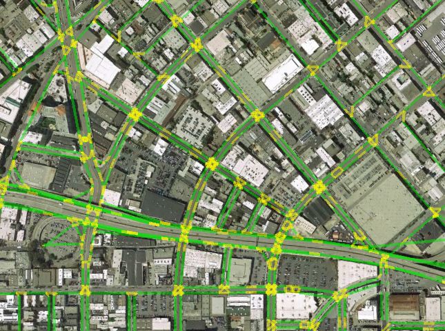
The road segments and intersections are obtained from same as in Full-Model. This variant has a compu-
mapping data, as represented in Figure 4. Both segments tational advantage compared to other variants above.
and intersections are directional. However, it restricts the allowed behavior by assuming
people always choose the shortest path to the destina-
6. EXPERIMENTS tion.
We present the experimental results of the two challenge
tasks described in Section 4 : inferring the past and predict- 6.3 Experimental Setup
ing the future. However, we first present the features used
To carry out the tasks described above we randomly chose
to learn the speed of road segments.
30% of the trajectories as the test set. We held out a ran-
6.1 Feature Sets for Learning Speeds domly selected internal GPS point of each trajectory in this
set to accomplish the task of inferring the past. To predict
We constructed a set of binary features, φ for each road the future, we elided the last point in the trajectory. To
segment to learn the speed of road segments as detailed in use these removed points for evaluation, their true location,
Section 2.6. Note that φ denotes the features of a road which is required in estimating the travel time, is chosen to
segment instances, i.e. the appearance of a road segment be the nearest point in a road segment.
within a given trajectory at a given time. These features We trained a single model on all trajectories from the four
can be categorized into three sets: cities. We ran the optimization algorithm for a set of itera-
Road features. These features capture several facets of tions until convergence. In each iteration, we randomly sam-
the road attributes such as road type “major road”, pled 1,000 trajectories from a random zip code area for pro-
”high way”, etc. cessing. The search diameter, namely the maximal distance
Temporal features. We sliced time into workday and week- from possible true locations (states) to observed locations,
end hours to obtain 48 features. A given road segment was limited by 50 meters. For computing expectations over
instance was assigned to an hour based on the time of hidden paths ξ, we also limited ourselves to paths containing
the majority of GPS points that fell into it. at most 15 road segments, which was roughly 1.5 kilometer
Individual Speed. We used trajectory ID as the feature to long. Those paths were computed by the breadth-first search
model individual speed preference along the trajectory. algorithm and stored at the beginning before optimization
This produced tens of millions of unique features. starts. Hence all possible paths between two locations could
be fetched during training. The running time of the training
We combined road and time features to obtain cross-features. procedure took several hours on a single machine with a par-
In other words, a feature from the road feature group was allel implementation. In other words, the dynamic program
paired with a feature from the time feature group to form on each trajectory was parallelized.
a new feature. This new feature has value 1 if and only if We fixed δd = 100 and δl = π4 for the motion model.
the former two are both equal to 1. This allows us to model The learning rates were chosen from the interval [1, 0.01]
non-linear interactions between features since we employ a by examining the convergence rate. Empirically we found
linear model as described in Section 2.6. This feature com- that the features constructed from the trajectory IDs (in the
bination is also equivalent to a hierarchical model. Due to Individual speed group) are much sparser than the other two
the large size of the trajectory feature group, we did not feature groups. This imbalance slows the convergence of the
combine it with other features. stochastic gradient descent. Instead of performing feature
normalization, we placed different learning rates η1 and η2
6.2 Models Compared of these two kinds of features respectively. In addition, we
To our best knowledge, most of the work in the literature only tune η1 by fixing η2 = 10η1 . Lastly, we used the top 5
(as we will discuss in Section 7) focuses on on personalized candidate paths when predicting future locations.Table 1: Average errors of estimating past locations and travel times.
time error (sec.) location error (m) heading direction error (·◦ )
SF NYC Boston Salina SF NYC Boston Salina SF NYC Boston Salina
Full-Model 2.27 3.23 1.21 0.82 26.9 40.1 16.0 19.2 20.8 19.3 12.6 16.8
common 2.38 3.36 1.43 0.80 25.9 38.0 17.0 18.3 17.6 16.6 11.0 15.2
GPS-speed 2.99 4.51 1.85 0.98 31.5 50.3 22.3 21.7 17.2 19.1 12.4 14.1
Shortest-path 2.28 3.27 1.25 0.81 26.1 39.7 16.2 19.2 21.8 20.0 12.9 18.3
Table 2: Average error of predicting a future location and the travel time. The top 5 locations candidates are considered.
time error (sec.) location error (m) heading direction error (·◦ )
SF NYC Boston Salina SF NYC Boston Salina SF NYC Boston Salina
Full-Model 3.56 4.83 2.41 1.19 57.8 70.5 44.4 33.5 20.1 19.3 12.9 16.3
common 3.95 5.20 2.81 1.27 67.1 77.6 50.9 36.3 17.4 16.2 11.2 15.5
GPS-speed 4.71 6.62 3.41 1.42 59.8 77.8 50.7 31.2 19.8 19.4 12.9 17.0
Shortest-path 4.40 6.03 2.73 1.46 68.7 83.4 49.2 40.6 22.1 21.5 12.9 19.3
35 35
SF SF SF
NY NY
Average Speed (m/s)
Average Speed (m/s)
15 NY 30 30
Boston Boston Boston
Frequency (%)
Salina Salina Salina
25 25
10
20 20
5
15 15
0 10 10
0 10 20 30 40 0 4 8 12 16 20 0 4 8 12 16 20
Speed (m/s) Hours Hours
Figure 5: Left: histogram of learned travel speeds. There is a reduction of low speeds portion comparing to the recorded GPS
speeds in Figure 3. Middle and right: travel speed as a function of the time of day on weekdays and weekend. As before, the
effect of rush hours are quite visible in their reduction of travel speeds.
6.4 Learned Travel Speeds 20
The learned travel speeds are demonstrated in Figure 5.
The positions of the modes in the histogram of the learned
speeds are similar to the ones from GPS which were shown in
Figure 3. However, a noticeable differences is the significant 15
Speed (m/s)
reduction of low speeds (less than 10m/s). These speeds
might have happened near a red traffic light or a stop sign.
The proposed model has a smoothing effect because it uses 10
a smoothed constant speed between two locations and thus
misses these range of speeds.
There is a strong pattern of the fall and rise of the trav-
eling speed along time as shown in Figure 5. As expected, 5
the traveling speed decreases during the two rush hours in
weekdays in all cities. However this effect is less obvious in
Salina, whose traffic is mainly on the interstate highways.
0
0 0.2 0.4 0.6 0.8 1
6.5 Time and Location Prediction Position
We first present the results of estimating past locations Figure 6: Recorded speeds in different positions of a road
and travel times. The average test errors are summarized segment during the time between 7pm and 9pm.
in Table 1. The average test errors of travel time, location,
and heading direction are below 5 seconds, 50 meters, and
20 degrees, respectively. Several reasons contributed to the The estimation errors differ among cities, which can be
errors, such as the complexity of city roads, e.g. frequent better observed in the top of Figure 7. As expected, the
turning and waiting, and the degradation of data precision existence of major arterial highways in Boston and Salina
due to urban canyons. We believe that our models fit the makes the estimation problem easier than in SF and NYC
data reasonably well. because the speed has lest variation in highways than local7 error as expected (since we have less constraints). However,
the errors are still within reasonable ranges. The increase of
errors in time, location and heading directions are less than
6 2 second, 40 meters, and almost 0, respectively.
The same conclusion observed from estimating past loca-
Time error (sec)
5 tions are still applicable when estimating future locations.
NYC In addition, the model Full-Model with all functionality
4 performs better than the slightly simplified model common
and then the model that only takes shortest paths into con-
3 SF sideration. There are two reasons for this. First, the as-
sumption that people always choose the shortest path may
2 individual−speed be too restrictive. People take a longer path for several pos-
Boston common sible reasons: easier to drive, personal preference, or even
1 GPS−speed due to turning mistakes. Taking into account a few more
Salina possible paths take into considerations this variation bet-
shortest−path ter. Second, the travel time and location are predicted by
0 the motion model while in the previous task (predicting the
20 40 60 80
past) we simply interpolate the values. Hence a better mo-
Location error (m) tion model like Full-Model that takes into consideration
7 individual preference, is more likely to have better individ-
ual motion models and therefore gives better results in the
6 NYC future-prediction task.
Time error (sec)
5 7. RELATED WORK
SF There is increasing interest in estimating and predicting
4 travel times as the GPS devices become more available on
recent years. There are mainly two research directions. The
Boston first is mapping an observed noisy GPS location to a real
3
location, and recovering the trajectory from temporal data.
2 individual−speed There is a rich of work in this topic, such as [11, 9, 3]. [8]
common models the whole trajectory path by taking account of the
Salina road speed constraint while [10] adopts a HMM model. A
1 GPS−speed related topic is inference the map from the GPS trajectories
shortest−path [7].
0 The second direction of research is more focused on mea-
20 40 60 80 suring and predicting the travel time. Most of the work in
Location error (m) the literature is focused on high frequency, long sequence
of GPS data [14] or highway traffic estimation [15]. [4]
Figure 7: Top: location and time error for different cities
presented a probabilistic model of travel time in arterial
when performing interpolation. Bottom: corresponding ex-
network based on taxi GPS data. The travel time of each
trapolation errors.
road segment is modeled independently as a Normal and log-
normal distribution. A lower-bound of the log-likelihood is
solved by an EM-like algorithm to avoid the computational
city roads. Moreover, Manhattan has a higher density of intractable integrals. [13] used a similar model but from a
roads and people than the San Francisco area. As expected Bayesian approach with an MCMC algorithm for inference.
it has larger estimation error than the latter. Very recently, [12] used a tensor decomposition method on
Next we turn to comparing the different variants of the Beijing taxi GPS data.
models. The best (statistically significant) results are high- By observing that travel times are usually correlated be-
lighted via underlines in Table 1, which are also visualized tween adjacent roads, [5] proposed modeling the travel times
in Figure 7. As can be seen, the model GPS-speed performs by general features which are related to the road and tem-
worse than the other models. We believe this happens be- poral information. However, their work assume the true
cause the infrequently sampled GPS points induce highly position and paths are available. [16, 17] also used general
variable recorded speeds which in turn increases the esti- features to modeling taxi driver preference from the inverse
mation errors. To see this point, refer to to Figure 6 which reinforcement learning approach.
shows the recorded speeds at a particular road segment have Our work is different on several aspects. First our model
a large variation. In addition, the gap between GPS-speed can not only map trajectories to real locations but also mod-
and the best two other models increase from Salina to NYC eling road speed and variance, and predicting future travel
(left to right in Figure 7), where the traffic environment be- time and position. Second, we focus on noisy and sparsely
comes more complex. sampled anonymous GPS sequences, while most of the work
Finally we show the results of predicting future locations in the literature focus on long, personalized and densely
and travel time in Table 2 and also in the bottom of Figure 7. sampled GPS sequences or high precision high-wag data.
Comparing to the result obtained when inferring past loca- Third, we model the travel speeds and variance as a func-
tions, there is an increase on both location error and time tion of road, time and personal preference and we considernon-linear models. Fourth, the travel time is modeled as [7] Xuemei Liu, James Biagioni, Jakob Eriksson, Yin
an inverse Gaussian distribution with the path speeds and Wang, George Forman, and Yanmin Zhu. Mining
variance as parameters. During inference the gradient can large-scale, sparse gps traces for map inference:
be computed in a simple close form. Thus this gives a more comparison of approaches. In Proceedings of the 18th
faithful approximation of the data as we shown in Figure 1 ACM SIGKDD international conference on Knowledge
and is more computationally efficient due to the existence of discovery and data mining, pages 669–677. ACM,
a closed form solution. Fifth, we perform a joint inference 2012.
over mapping observations to true locations, discovering pos- [8] Yin Lou, Chengyang Zhang, Yu Zheng, Xing Xie, Wei
sible paths, and inferring travel times. We achieved this by Wang, and Yan Huang. Map-matching for
a probabilistic model that considers all possible mapping se- low-sampling-rate gps trajectories. In Proceedings of
quences, potentially paths between two locations, and road the 17th ACM SIGSPATIAL International Conference
transition probabilities. Finally, most importantly, we use on Advances in Geographic Information Systems,
millions of trajectories from different cities to demonstrate pages 352–361. ACM, 2009.
the scalability of the proposed algorithm. This data is an [9] Tomio Miwa, Daisuke Kiuchi, Toshiyuki Yamamoto,
order of magnitude larger than previous work. and Takayuki Morikawa. Development of map
matching algorithm for low frequency probe data.
8. CONCLUSION Transportation Research Part C: Emerging
Technologies, 22:132–145, 2012.
Nowadays there are new challenges to the task of infer-
[10] Paul Newson and John Krumm. Hidden markov map
ring movement from GPS data. The data may be short
matching through noise and sparseness. In Proceedings
and anonymous due to increasing demand of privacy con-
of the 17th ACM SIGSPATIAL International
trol. The limited power capacity of mobile devices places
Conference on Advances in Geographic Information
extra constraints on the sampling frequency of locations,
Systems, pages 336–343. ACM, 2009.
inducing temporal sparse GPS recordings. The spatial cov-
[11] Mahmood Rahmani and Haris N Koutsopoulos. Path
erage and volume of these GPS snippets is quite high due
inference of low-frequency gps probes for urban
to increasing availability of smart phones and other mobile
networks. In IEEE Conference on Intelligent
GPS devices.
Transportation Systems (ITSC), pages 1698–1701.
In this paper we presented an efficient probabilistic model
IEEE, 2012.
to analyze this challenging GPS snippet data to perform
the following three tasks simultaneously: location mapping, [12] Yilun Wang, Yu Zheng, and Yexiang Xue. Travel time
path discovery and travel time estimation. We give an effi- estimation of a path using sparse trajectories. In
cient scalable inference algorithm and demonstrated its effi- Proceeding of the 20th SIGKDD conference on
ciency by using tens of millions of GPS trajectories snippets Knowledge Discovery and Data Mining, 2014.
from four different cities. The experimental results showed [13] Bradford S Westgate, Dawn B Woodard, David S
that this algorithm performed well on both estimating past Matteson, and Shane G Henderson. Travel time
and predicting future locations and travel times. estimation for ambulances using bayesian data
augmentation. Annals of Applied Statistics, 2013.
[14] Daniel B Work, O-P Tossavainen, Sébastien Blandin,
9. REFERENCES Alexandre M Bayen, Toch Iwuchukwu, and Ken
[1] Christopher Bishop. Pattern Recognition and Machine Tracton. An ensemble kalman filtering approach to
Learning. Springer, 2006. highway traffic estimation using gps enabled mobile
[2] T. Gärtner, P. A. Flach, A. Kowalczyk, and A. J. devices. In IEEE CDC, pages 5062–5068. IEEE, 2008.
Smola. Multi-instance kernels. In Proceedings of the [15] Yufei Yuan, JWC Van Lint, R Eddie Wilson, Femke
International Conference on Machine Learning, pages van Wageningen-Kessels, and Serge P Hoogendoorn.
179–186. Morgan Kaufmann Publishers Inc., 2002. Real-time lagrangian traffic state estimator for
[3] Timothy Hunter, Pieter Abbeel, and Alexandre M freeways. IEEE Trasaction on Intelligent
Bayen. The path inference filter: model-based Transportation Systems, 13(1):59–70, 2012.
low-latency map matching of probe vehicle data. In [16] Brian D Ziebart, Andrew L Maas, J Andrew Bagnell,
Algorithmic Foundations of Robotics, pages 591–607. and Anind K Dey. Maximum entropy inverse
Springer, 2013. reinforcement learning. In AAAI, pages 1433–1438,
[4] Timothy Hunter, Ryan Herring, Pieter Abbeel, and 2008.
Alexandre Bayen. Path and travel time inference from [17] Brian D Ziebart, Andrew L Maas, Anind K Dey, and
gps probe vehicle data. NIPS Analyzing Networks and J Andrew Bagnell. Navigate like a cabbie:
Learning with Graphs, 2009. Probabilistic reasoning from observed context-aware
[5] Erik Jenelius and Haris N Koutsopoulos. Travel time behavior. In Ubiquitous Computing, pages 322–331.
estimation for urban road networks using low ACM, 2008.
frequency probe vehicle data. Transportation Research
Part B: Methodological, 53:64–81, 2013.
[6] J. Kivinen and M. K. Warmuth. Additive versus
exponentiated gradient updates for linear prediction.
In Proc. 27th Annual ACM Symposium on Theory of
Computing, pages 209–218. ACM Press, New York,
NY, 1995.You can also read


