Inspection note on the recent visit to Syari Landslide, Deorali, Gangtok, East District, Sikkim
←
→
Page content transcription
If your browser does not render page correctly, please read the page content below
Inspection note on the recent visit to Syari Landslide, Deorali,
Gangtok, East District, Sikkim
Geological Survey of India, North-Eastern Region, State Unit: Sikkim, Gangtok
A large crack was reported on 09.08.2018 on Upper Syari road, near Deorali, Gangtok,
East District, Sikkim. (Fig. 1). The location is in the vicinity of residential complex of Auditor
General (AG) office, Government of India. The failure was initiated on 10.08.2018. The
landslide (zone of depletion) is located at a location having coordinates 27°18’57”N and
88°36’24”E and the area lies in the Survey of India Toposheet No. 78A/11. A visit was made to
the affected area and field investigation was carried out on 14.08.2018 to assess the landslide and
evaluate the causative factors by the officers of Geological Survey of India, North Eastern
Region, State Unit: Sikkim, Gangtok.
Preliminary field observation confirmed that the Upper Syari landslide was characterised
by a slow movement along with fall of debris material along a steep slope (>45°), due to the
bulging and action of gravity. This resulted in the accumulation of huge amount of debris just
behind the AG residential complex. The dimension of this landslide is small, having length of
about 80 m, width of about 150 m, height of about 60 m, total run out distance of about 100 m.
The depth to failure surface being more than 2 m (deep seated). The failure is debris slide, which
are quite common in Himalayas. During the active movement of this failure, a huge impact of
moving rock boulders and a relatively moist debris have been created on the residential
buildings. The type of overburden is weathered and unconsolidated rock and soil having
thickness of 1-2m. The rocks are highly fractured. The failure has been initiated with the
appearance of cracks which subsequently enlarged. There is excess overburden pressure, which
resulted in bulging and failure of slope material. Geomorphologically, the affected area is lowly
dissected with sparse vegetation. Some parts of the affected area are also having agricultural land
along with heavy settlements.
The tentative geoscientific reasons of this landslide as observed could be i) slope failure,
ii) heavy rainfall, iii) local shearing/ fracturing rendering poor quality of slope material, iv) pore
water pressure v) steeper slope morphometry. During last few days there had been significant
rainfall in the area. Hence, pore water pressure developed due to long saturation of antecedent
rainfall could have also played a pivotal role in triggering this failure.
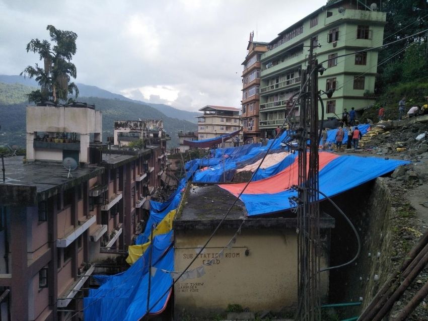
This failure damaged buildings, roads, water supply line and power supply lines but
fortunately no causalities took place. A proper heavy load bearing gabion wall along the slope is
required immediately to hold the overburden material and to keep the buildings safe. Proper
drainage is essentially required to avoid any other failures.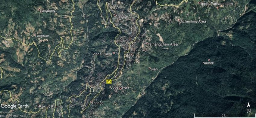
Fig. 1: Location of Upper Syari failure (Source: Google Earth)

   Fig 2: The affected slope due to failure in Upper Syari.

Fig. 3 & 4: The failure affecting the slope and the buildings in Upper Syari.

42-Point Geo-parametric attribute of Landslide (Causes, Remedial Measures & Others)
No Field                         Description
1    Slide No (LS .No.)          State: Sikkim/district: East District/toposheet: 78A/11/year:
                                 2018/serial no.
2    State                       Sikkim
3    District                    East District
4    Toposheet                   78A/11
5    Name of the slide/ failure  Upper Syari, Deorali, Gangtok
6    NH/SH/Locality              Near Butter fly Chowk, Syari, Deorali, Gangtok
7    Latitude                    27o18’57’’N
8    Longitude                   88o36’24’’E
9    Length                      80 m
10 Width                         150 m
11 Height                        60 m
12 Area                          12X103sq m
13 Depth                         2m
14 Volume                        24X103 cu m
15 Run out distance              NA
16 Type of Material              Debris
17 Type of movement              Bulging and slope failure
18 Rate of movement              Slow
19 Activity                      Active
20 Distribution                  NA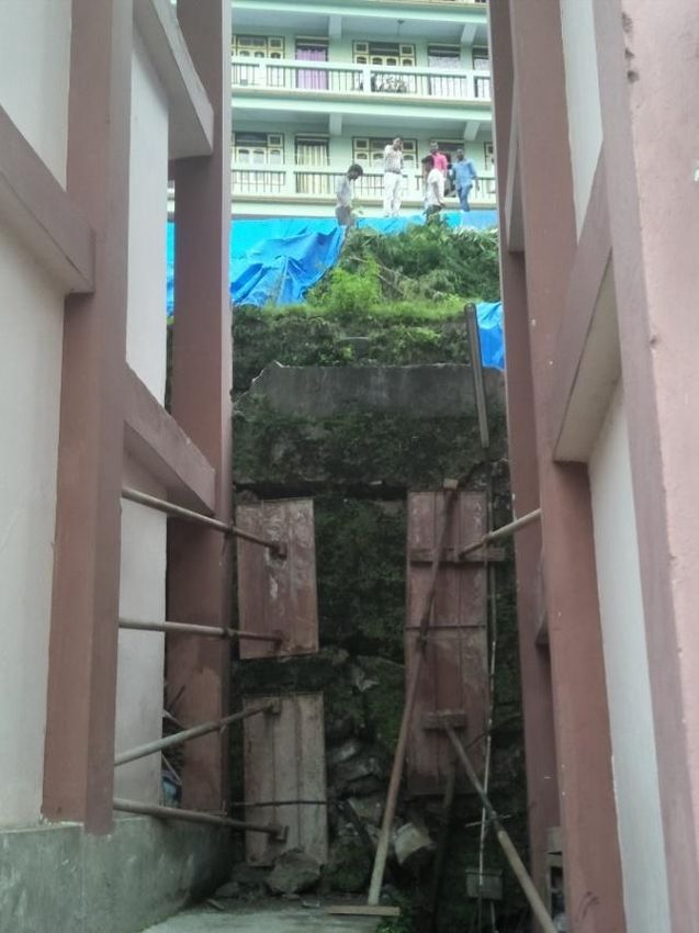
21   Style                       Single
22   Failure mechanism           Bulging and slope failure
23   History                     Date of initiation: 7thAugust 2018,
                                 subsequent reactivations 9th August 2018
24   Geomorphology               Moderate to steep slope
25   Geology                     The rocks of the surrounding area belong to Kanchanjunga
                                 gneiss of CCGC (Central Crystalline Gneissic Complex) as
                                 basement rock, covered entirely with paleoslide material.
26   Structure                   NA (As the area is completely covered by heavy settlement).
27   Land use/ Land cover        Sparse trees and heavy settlement
28   Hydrological condition      Seasonal stream
29   Triggering Factor           Excess load of the settlement.Excess rain water percolation,
                                 creating hydrological pressure, resulting in the failure.
30   Death of persons            Nil
31   People affected             None
32   Live stock loss             Nil
33   Communication                Road (blocked/damaged), disruption in water supply line and
                                 power cables
34   Infrastructure              Cracks on the road and in the settlement
35   Agriculture/forest/Barren   Sparse trees
36   Geo-scientific Causes       Combination of excess loadof the settlement along with pore
                                 water pressure
37   Remedial measures           Evacuation from the affected area, making arrangement for
                                 proper drainage and diversion of flowing stream, erecting
                                 gabion wall
38   Remarks, if any             Cracks appeared on the road first and then enlarged within
                                 24 hrs.
39   Photos. Sketch of Plan &    Attached with note.
     section of the slide
40   Summary/Abstract            Attached with note.
41   Pdf                         Attached
42   Landslide Category          Type…..
You can also read