INSTA PT 2021 EXCLUSIVE - GEOGRAPHY AND PLACES IN NEWS JUNE 2020 - MARCH 2021 - Insights
←
→
Page content transcription
If your browser does not render page correctly, please read the page content below
INSTA PT 2021
  EXCLUSIVE
GEOGRAPHY AND
PLACES IN NEWS
JUNE 2020 – MARCH 2021
INSTA PT 2021 EXCLUSIVE (GEOGRAPHY AND PLACES IN NEWS)
NOTES
Table of Contents
Important Geophysical phenomena and geographical features .................. 4
1. SPACE HURRICANE ...................................................................................................... 4
2. CYCLONES ................................................................................................................... 4
3. WHY DID CYCLONES GIVE OCTOBER A MISS? .............................................................. 6
4. WHY FLOODS OCCURRED IN HYDERABAD ................................................................... 6
5. TYPHOON ................................................................................................................... 7
6. POLAR VORTEX ........................................................................................................... 7
7. LIGHTNING ................................................................................................................. 8
8. SADIYA EARTHQUAKE.................................................................................................. 8
9. HOW MOUNT EVEREST GOT 3 FEET HIGHER ............................................................... 8
10. AURORA BOREALIS AND AURORA AUSTRALIS .......................................................... 9
11. EL NINO ................................................................................................................. 10
12. LA NIÑA ................................................................................................................. 11
13. SOLAR ECLIPSE ...................................................................................................... 11
14. GEMINIDS METEOR SHOWER ................................................................................ 12
15. DIP IN DELHI’S TEMPERATURE ............................................................................... 13
16. IN TREE RINGS, WARNING OF BRAHMAPUTRA FLOODS ......................................... 13
17. GEOTHERMAL SPRINGS IN HIMALAYAS .................................................................. 14
18. VOLCANOES .......................................................................................................... 14
19. ARAVALI RANGE .................................................................................................... 15
20. ZEALANDIA ............................................................................................................ 15
Places in News .......................................................................................... 17
1. INTERNATIONAL NORTH SOUTH TRANSPORT CORRIDOR ........................................... 17
2. CHINA’S STRING OF PEARLS ...................................................................................... 17
3. TAIWAN .................................................................................................................... 17
4. KENYA AND SOMALIA................................................................................................ 18
5. SOUTH CHINA SEA .................................................................................................... 18
6. EAST CHINA SEA ........................................................................................................ 18
7. MYANMAR ................................................................................................................ 19
8. SUEZ CANAL .............................................................................................................. 19
9. INDO- PACIFIC ........................................................................................................... 19
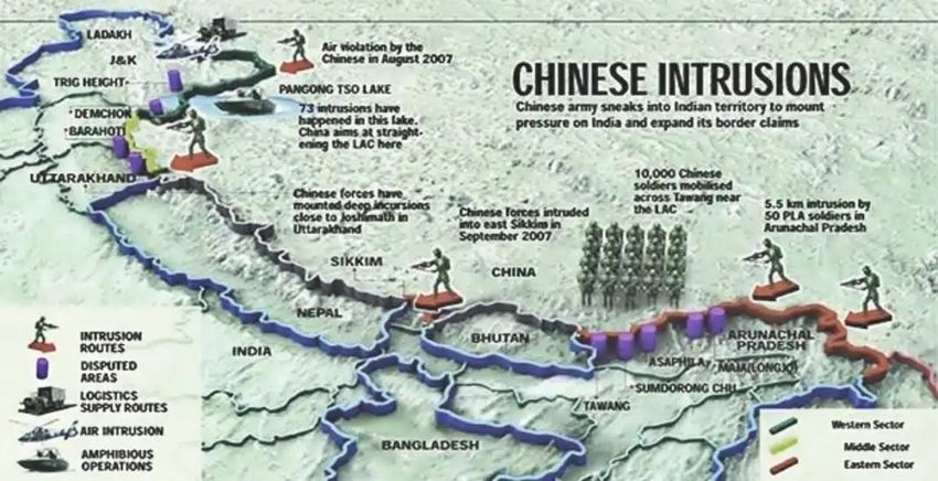
10. PANGONG TSO ...................................................................................................... 19
11. CHUSHUL .............................................................................................................. 20
12. PANGDA VILLAGE .................................................................................................. 20
13. DOKLAM AND NAKU LA ......................................................................................... 20
14. KALAPANI .............................................................................................................. 21
15. SHAHTOOT DAM ................................................................................................... 21
16. BHASAN CHAR ....................................................................................................... 21
17. ARAB NATIONS ...................................................................................................... 22
18. PERSIAN GULF ....................................................................................................... 22
19. SINAI PENINSULA................................................................................................... 22
20. WEST BANK ........................................................................................................... 23
21. CASPIAN SEA ......................................................................................................... 23
22. TURKEY ................................................................................................................. 23
23. BAMIYAN............................................................................................................... 23
www.insightsonindia.com 1 InsightsIAS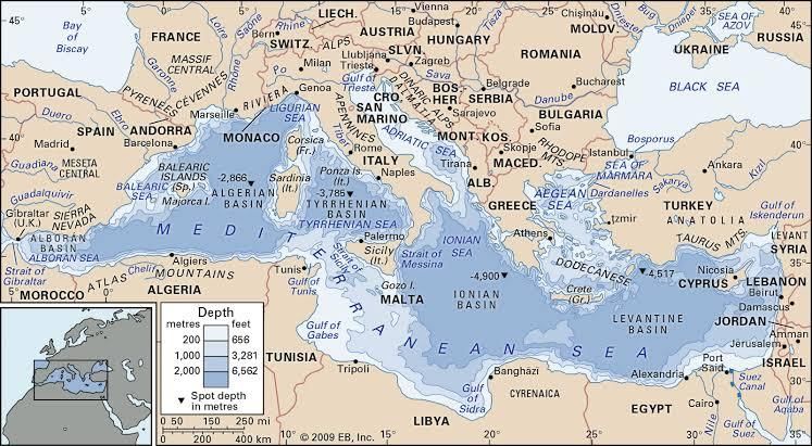
INSTA PT 2021 EXCLUSIVE (GEOGRAPHY AND PLACES IN NEWS)
NOTES
24. HAGIA SOPHIA AND CHORA ................................................................................... 23
25. NAGORNO-KARABAKH ........................................................................................... 24
26. PUERTO RICO: ....................................................................................................... 24
27. TRISTAN DA CUNHA:.............................................................................................. 24
28. THAILAND ............................................................................................................. 24
29. MEKONG RIVER ..................................................................................................... 25
30. BORNEO ISLAND .................................................................................................... 25
31. KATCHATHEEVU .................................................................................................... 25
32. KYRGYZSTAN ......................................................................................................... 25
33. NEW CALEDONIA ................................................................................................... 26
34. MEDITERRANEAN SEA ........................................................................................... 26
35. FIJI......................................................................................................................... 26
36. CRETE ISLAND........................................................................................................ 27
37. SIR CREEK .............................................................................................................. 27
38. PEARL RIVER ESTUARY ........................................................................................... 27
39. DEMCHOK SECTOR ................................................................................................ 27
40. SUMDORONG CHU ................................................................................................ 27
41. GRAND ETHIOPIAN RENAISSANCE DAM (GERD) ..................................................... 28
42. ETHIOPIA ............................................................................................................... 28
43. NILE RIVER............................................................................................................. 29
44. KAILASH RANGE..................................................................................................... 29
45. DAULAT BEG OLDIE ............................................................................................... 30
46. NATHU LA ............................................................................................................. 30
47. BARALACHA PASS .................................................................................................. 30
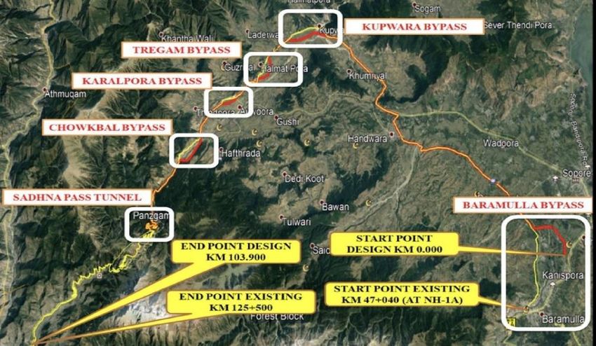
48. SADHNA PASS ........................................................................................................ 30
49. ROHTANG PASS ..................................................................................................... 31
50. DZUKOU VALLEY .................................................................................................... 31
51. NORTH SENTINEL ISLAND ...................................................................................... 31
52. HALDIBARI-CHILAHATI RAIL LINK............................................................................ 31
53. KILAUEA VOLCANO ................................................................................................ 32
54. KEVADIA ................................................................................................................ 32
55. ASSAM-MIZORAM BOUNDARY ISSUES ................................................................... 32
56. SARASVATI RIVER .................................................................................................. 32
57. SABARMATI RIVER ................................................................................................. 33
58. INDUS RIVER.......................................................................................................... 33
59. BEAS RIVER ............................................................................................................ 33
60. YAMUNA RIVER ..................................................................................................... 34
61. NAG RIVER ............................................................................................................ 34
62. TSARI CHU RIVER ................................................................................................... 34
63. AGATTI ISLAND ...................................................................................................... 35
64. INDIA AND BANGLADESH BORDER ......................................................................... 35
65. MUNDRA PORT ..................................................................................................... 35
Dams and River Water Sharing Agreements .............................................. 36
1. MULLAPERIYAR DAM ................................................................................................ 36
2. EASTERN RAJASTHAN CANAL PROJECT (ERCP) ........................................................... 36
3. KEN-BETWA INTERLINKING PROJECT ......................................................................... 37
4. POLAVARAM PROJECT............................................................................................... 37
5. PAKAL DUL HYDRO ELECTRIC PROJECT ...................................................................... 37
www.insightsonindia.com 2 InsightsIAS
INSTA PT 2021 EXCLUSIVE (GEOGRAPHY AND PLACES IN NEWS)

                                                                                                                                    NOTES
Miscellaneous ........................................................................................... 38
1.   DHUBRI-PHULBARI BRIDGE ....................................................................................... 38
2.   COAL SECTOR IN INDIA.............................................................................................. 38

www.insightsonindia.com                                                3                                                     InsightsIAS
INSTA PT 2021 EXCLUSIVE (GEOGRAPHY AND PLACES IN NEWS)

                                                                                                         NOTES
    Important Geophysical phenomena and geographical features
1. Space hurricane
Scientists from China recently discovered a space hurricane for the first time ever above the
North pole.
● Previously, it was believed, space hurricanes were a theoretical phenomenon.

As per their report, the hurricane measured roughly 600 miles across and rained down charged
electrons for as long as eight hours.

Why it matters?
The new finding could help scientists learn more about how the Sun affects Earth's atmosphere,
gathering more details on how space weather might harm satellites and other objects in orbit.

What are space hurricanes?
● They are thought to be a result of the solar wind and Earth's magnetic field interacting.
● It is a huge, funnel-like, spiral geomagnetic storm that occurs above the polar Ionosphere of
  Earth, during extremely quiet conditions.
● They are related to the aurora borealis phenomenon, as the electron precipitation from the
  storm's funnel produces gigantic, cyclone-shaped auroras.
● They are made up of plasmas, consisting of extremely hot ionized gases that rotate at
  extremely high
  speeds.

Formation:
Space hurricanes are
caused by plasma
unleashed from the
sun as solar wind.
These charged
particle clouds travel
through space and
fuel magnetic storms
as they interact with
magnetic fields.

Impact:
● The researchers think these kinds of storms could create more drag on satellites and
   interfere with radio signals and communications, making these events particularly important
   to understand.

2. Cyclones
Seven days after Cyclone Nivar hit
the Karaikal coast, another cyclone,
Burevi, crossed Tamil Nadu's
southernmost district of
Kanyakumari.

Why Cyclone Burevi wasn't as strong
as Cyclone Nivar?

www.insightsonindia.com                                   4                                       InsightsIAS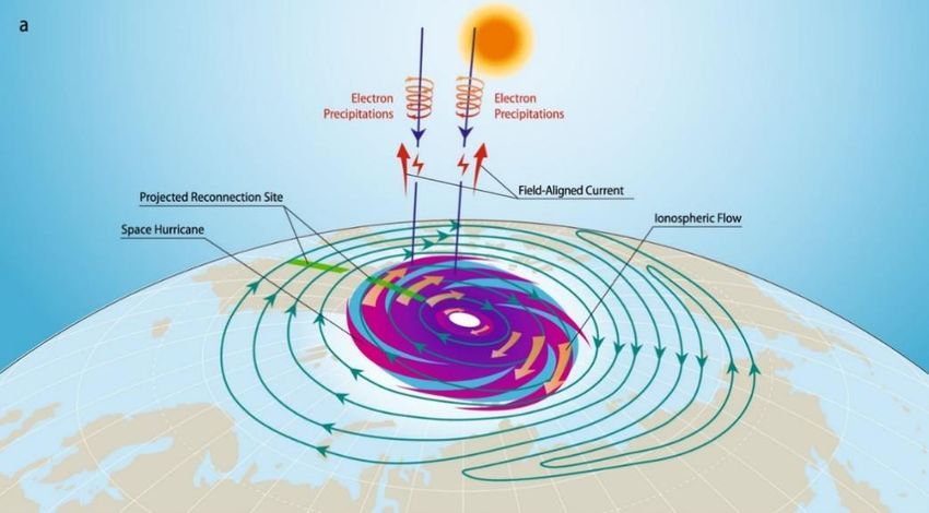
INSTA PT 2021 EXCLUSIVE (GEOGRAPHY AND PLACES IN NEWS)

                                                                                                           NOTES
•   Due to upwelling caused by Nivar, Cyclone Burevi had limited intensity.
●   When such consecutive systems develop in the same region of the ocean, the predecessor
    system leads to upwelling -- the process in which cooler waters from lower ocean surfaces are
    pushed towards upper ocean surfaces.
●   In the absence of warm sea surface conditions, any cyclone, in this case Burevi, will not get
    enough fuel to intensify further while at sea.

What is a cyclone?
Tropical Cyclone is any large system of winds that
circulates about a center of low atmospheric
pressure in a counter-clockwise direction north of
the Equator and in a clockwise direction to the
south.

Cyclone formation:
● Cyclone is the formation of very low-pressure
    system with very high-speed winds revolving
    around it.
● Factors like wind speed, wind direction,
    temperature and humidity contribute to the
    development of cyclones.
● Before cloud formation, water takes up heat from the atmosphere to change into vapour.
    When water vapour changes back to liquid form as raindrops, this heat is released to the
    atmosphere.
● The heat released to the atmosphere warms the air around. The air tends to rise and causes a
    drop in pressure. More air rushes to the centre of the storm. This cycle is repeated.

What are the different parts of a
cyclone’s structure?
The eye: The eye of the storm is the
centre. It’s a relatively calm space.
When the eye passes over an area,
winds slow down and everything feels
like it has cleared up. The part that
comes after the eye usually inflicts the
most damage.

The eyewall: This is where the most
effective part of a cyclone rests. The
eyewall houses extremely high wind speeds, causing damage to both lives and property. It is a
ring of thunderstorms, and changes in the eye or the eyewall affects the storm’s intensity.

Rainbands: These are the outer parts of a cyclone where sudden bursts of rain happen. There can
also be gaps betwen rainbands where no rain or wind occurs.

General factors responsible for the origin of Cyclones in Bay of Bengal region are:
1. Large sea surface with temperature higher than 27° C.
2. Presence of the Coriolis force enough to create a cyclonic vortex.
3. Small variations in the vertical wind speed.
4. A pre-existing weak low-pressure area or low-level-cyclonic circulation.
5. Upper divergence above the sea level system.

Arabian Sea is comparatively less prone to cyclonic storms than Bay of Bengal:

www.insightsonindia.com                                   5                                         InsightsIAS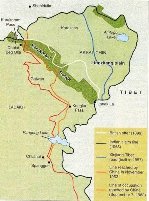
INSTA PT 2021 EXCLUSIVE (GEOGRAPHY AND PLACES IN NEWS)

                                                                                                          NOTES
•   Temperature: BOB is hotter than Arabian sea. Hot water temperature is the basic criteria for
    the development & intensification of cyclones.
•   Salinity: Arabian sea has higher salinity than BOB. It’s easier to heat & simultaneously
    evaporate water having lower salinity.
•   Location: The typhoons originating in the Pacific Ocean too influences the cyclones in BOB,
    not the case in Arabian Sea.
•   Movement: According to IMD cyclones originating in Arabian Sea are believed to move
    northwest. So they actually move away from Indian mainland.
•   The Bay receives higher rainfall and constant inflow of fresh water from the Ganga and
    Brahmaputra rivers. This means that the Bay’s surface water keeps getting refreshed, making
    it impossible for the warm water to mix with the cooler water below, making it ideal for a
    depression.

3. Why did cyclones give October a miss?
October to December period is among the favourable months for the development of cyclones in
the Bay of Bengal and the Arabian Sea. In 2020, however, October passed without witnessing a
cyclonic storm.

Usually, when do cyclones form and hit Indian coasts?
About 80 cyclones are formed around the world annually, out of which five are formed in the Bay
of Bengal and the Arabian Sea, together known as the North Indian Ocean.
Cyclones in the North Indian Ocean are bi-modal in nature, that is, they occur during two
seasons— April to June (pre-monsoon) and October to December (post-monsoon).
● Of these, May and November remain the most conducive for the development of cyclones.

Why were there no cyclone developments?
● Ocean disturbances enter the Bay of Bengal from the South China sea side and head towards
  the Indian coast. However, there was no system which intensified to form a cyclone.
● Another reason is the weak La Nina conditions along the equatorial Pacific Ocean.
● There was also the influence of Madden Julian Oscillation (MJO). MJO is kind of an eastward-
  moving cyclic weather event along the tropics that influences rainfall, winds, sea surface
  temperatures and cloud cover. They have a 30 to 60-day cycle.
● Also, in November, the vertical wind shear created due to significant wind speed difference
  observed between higher and lower atmospheric level prevented the low-pressure systems
  and depression from strengthening into a cyclone.

4. Why floods occurred in Hyderabad
Hyderabad was recently listed as the rainiest place in the country by Skymet, an independent
weather forecasting agency, after it recorded 72.5mm of rainfall.

What caused this havoc?
This was caused by a weather that formed in
the Bay of Bengal, hit the east coast and
moved westward, weakening on the way.
● Normally, cyclones lose steam upon
    making their landfall. This particular
    system, however, clocked a long east-west
    track cutting across Andhra Pradesh,
    Telangana, north-interior Karnataka and
    Maharashtra.
● All these states experienced above-normal
    rain during the monsoon season. As a
    result, the soil in these regions has retained significant moisture content.

www.insightsonindia.com                                    6                                       InsightsIAS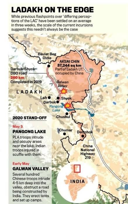
INSTA PT 2021 EXCLUSIVE (GEOGRAPHY AND PLACES IN NEWS)

                                                                                                             NOTES
●   In addition, vertical wind shear — the result of a significant difference in wind speed between
    higher and lower atmospheric levels — helped the system maintain its intensity as a deep
    depression or a well-marked low pressure area even on land.

But, why floods occur in Hyderabad?
Hyderabad is a system of catchments.
1. The western edge is in the Godavari river basin.
2. To the east, it’s in the Krishna River basin.
3. Also, Hyderabad is in the Deccan region, which has a chaotic drainage pattern — water here
    does not flow in a single direction as the slope is in multiple directions.

5. Typhoon
Hurricanes, typhoons and cyclones: What's
the difference?
They are all the same thing: tropical storms.
But they are known by different names in
different locations.
1. In the North Atlantic Ocean and Northeast
     Pacific, they are called hurricanes.
2. But if the same type of disturbance takes
     place in the Northwest Pacific Ocean, it is
     known as a typhoon.
3. And in the South Pacific and Indian Ocean,
     cyclone is the correct term.

How storms form?
● Air rises quickly when it is heated by warm sea water.
● As the air cools down again it is pushed aside by more warm air rising below it.
● This cycle causes strong winds. Over the sea, a tropical storm can whip up huge waves.
● When these waves reach land they can flood large areas, including towns and cities.
● Over land the strong winds can cause a lot of damage - they can flatten homes, knock over
   trees and even tip over cars.

6. Polar vortex
Polar vortex is losing stability
and its splitting causes dramatic,
extreme weather implications
across the western nations such
as the US and Europe. With a
'disrupted' polar vortex in 2021,
the colder air is expected to spill
out of the Arctic and result in
the onset of extremely harsh
winters.

What exactly is a polar vortex?
It is described as a whirling cone
of low pressure over the poles
that is strongest in the winter
months due to the increased
temperature contrast between
the polar regions and the mid-
latitudes, such as the US and Europe.

www.insightsonindia.com                                   7                                           InsightsIAS
INSTA PT 2021 EXCLUSIVE (GEOGRAPHY AND PLACES IN NEWS)

                                                                                                              NOTES
Features:
● The polar vortex spins in the stratosphere.
● Usually, when the vortex is strongest, cold air is less-likely to plunge deep into North America
    or Europe. In other words, it forms a wall that protects the mid-latitudes from cold Arctic air.
● But occasionally, the polar vortex is disrupted and weakens, due to wave energy propagating
    upward from the lower atmosphere. When this happens, the stratosphere warms sharply in
    an event known as sudden stratospheric warming, in just a few days, miles above the Earth’s
    surface.
● The warming weakens the polar vortex, shifting its location somewhat south of the pole or, in
    some instances, ‘splitting’ the vortex up into ‘sister vortices’.

Effects of Polar Vortex:
● The split higher up in the atmosphere can give rise to both, sudden and delayed effects, much
    of which involves declining temperatures and extreme winter weather in the eastern US along
    with northern and western Europe.
● A sudden stratospheric warming also leads to a warm Arctic not only in the stratosphere but
    also in the troposphere as well.
● A warmer Arctic, in turn, favours more severe winter weather in the Northern Hemisphere
    mid-latitudes including the eastern US.

7. Lightning
●   It is a very rapid — and
    massive — discharge of
    electricity in the
    atmosphere, some of which
    is directed towards the
    Earth’s surface.
●   These discharges are
    generated in giant
    moisture-bearing clouds
    that are 10-12 km tall.
●   Every lightning strikes
    around a fixed period and
    almost similar geographical locations in similar patterns.

8. Sadiya earthquake
●   Scientists have found the first geological evidence of an earthquake at Himebasti Village on
    the border of Assam and Arunachal Pradesh, documented by historians as Sadiya earthquake.
●   Sadiya earthquake is recorded to have caused massive destruction in the region and almost
    destroyed the town in 1697 CE.
●   This finding could contribute to a seismic hazard map of the eastern Himalaya, which can
    facilitate construction and planning in the region.

9. How Mount Everest got 3 feet higher
The Foreign Ministers of Nepal and China jointly certified the elevation of Mount Everest at
8,848.86 metres above sea level 86 cm higher than what was recognised since 1954.

www.insightsonindia.com                                    8                                           InsightsIAS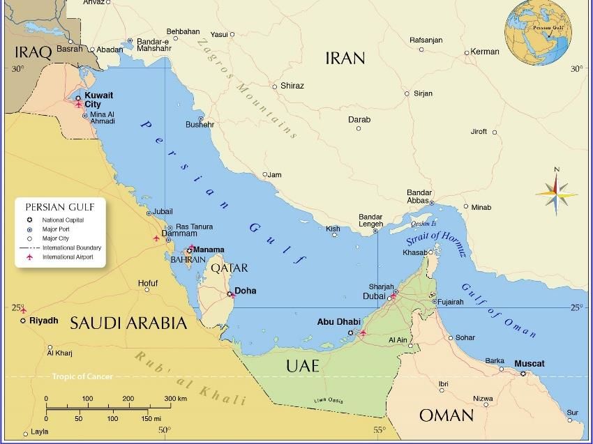
INSTA PT 2021 EXCLUSIVE (GEOGRAPHY AND PLACES IN NEWS)

                                                                                                             NOTES
About Mount Everest:
● Mount Everest rises from the border between
   Nepal and China.
● Everest is also known as Sagarmatha in Nepal
   and Mount Qomolangma in China.

How and when was the earlier measurement of
8,848 m done?
● Earlier measurement was determined by the
    Survey of India in 1954, using instruments like
    theodolites and chains, with GPS still decades
    away. The elevation of 8,848 m came to be
    accepted in all references worldwide except
    by China.
● In 1999, a US team put the elevation at 29,035 feet (nearly 8,850 m).

10. Aurora Borealis and Aurora Australis
The Northern Lights, also known as aurora borealis, are usually witnessed far up in the polar
regions or the high latitude regions of Europe. But, they could be visible in parts of Illinois and
Pennsylvania in the US.

Why?
This is due to a solar flare, which emerged from a Sunspot. The flare is accompanied by a Coronal
Mass Ejection (CME) — a large bubble of radiation and particles emitted by the Sun that explodes
into space at high speed. This causes the Northern Lights to be visible in more number of areas
than usual.

What is Aurora?
An Aurora is a display of light in the sky predominantly seen in the high latitude regions (Arctic
and Antarctic). It is also known as a Polar light.

Types:
There are two types- the aurora borealis and aurora australis – often called the northern lights
and southern lights.

Where do they occur?
They commonly occur at high northern and southern latitudes, less frequent at mid-latitudes, and
seldom seen near the equator.

Colors:
While usually a milky greenish color, auroras can also show red, blue, violet, pink, and white.
These colors appear in a variety of continuously changing shapes.

Science behind their occurrence:
● Auroras are a spectacular sign that our planet is electrically connected to the Sun. These light
    shows are provoked by energy from the Sun and fueled by electrically charged particles
    trapped in Earth’s magnetic field.
● The typical aurora is caused by collisions between fast-moving electrons from space with the
    oxygen and nitrogen in Earth’s upper atmosphere.
● The electrons—which come from the Earth’s magnetosphere, the region of space controlled
    by Earth’s magnetic field —transfer their energy to the oxygen and nitrogen atoms and
    molecules, making them “excited”.

www.insightsonindia.com                                     9                                         InsightsIAS
INSTA PT 2021 EXCLUSIVE (GEOGRAPHY AND PLACES IN NEWS)
NOTES
● As the gases return to their normal state, they emit photons, small bursts of energy in the
form of light.
● When a large number of electrons come from the magnetosphere to bombard the
atmosphere, the oxygen and nitrogen can emit enough light for the eye to detect, giving us
beautiful auroral displays.
Where do they origin?
They origin at altitudes of 100 to more than 400 km.
Why do auroras come in different colors and
shapes?
The color of the aurora depends on which gas —
oxygen or nitrogen — is being excited by the
electrons, and on how excited it becomes. The color
also depends upon how fast the electrons are
moving, or how much energy they have at the time of
their collisions.
Effects:
● Auroras affect communication lines, radio lines and power lines.
● It should also be noted here that Sun’s energy, in the form of solar wind, is behind the whole
process.
11. El Nino
As per latest findings, nearly six out of 10 droughts, in non-El Nino years, that occurred during
the Indian summer-monsoon season in the past century may have been driven by atmospheric
disturbances from the North Atlantic region.
● In 2014, India saw a 14% rainfall deficit — or a drought — that wasn't linked to El Nino and
before that in 1986 and 1985.
Factors that influence these droughts:
● These droughts are a consequence of a sudden and steep drop in rainfall in late August.
● Winds in the upper atmosphere are interacting with a deep cyclonic circulation above the
abnormally cold North Atlantic waters. The resulting wave of air currents, called a Rossby
wave, curved down from the North Atlantic squeezed in by the Tibetan plateau and hit the
subcontinent around mid-August, suppressing rainfall and throwing off the monsoon that was
trying to recover from the June slump.
What is El Nino?
● El Nino is a climatic cycle
characterised by high air
pressure in the Western
Pacific and low air
pressure in the eastern.
● During this event, there
is a warming of the sea
surface temperature in
the eastern and central
equatorial Pacific Ocean.
● It is one phase of an
alternating cycle known
as El Niño Southern Oscillation (ENSO).
www.insightsonindia.com 10 InsightsIASINSTA PT 2021 EXCLUSIVE (GEOGRAPHY AND PLACES IN NEWS)
NOTES
What causes El Nino?
● El Nino sets in when there is anomaly in the pattern.
● The westward-blowing trade winds weaken along the Equator and due to changes in air
pressure, the surface water moves eastwards to the coast of northern South America.
● The central and eastern Pacific regions warm up for over six months and result in an El Nino
condition.
12. La Niña
What is La Niña?
It means the large-scale cooling of
ocean surface temperatures in the
central and eastern equatorial
Pacific Ocean, together with changes
in the tropical atmospheric
circulation, namely winds, pressure
and rainfall.
● It has the opposite impacts on
weather and climate as El Niño,
which is the warm phase of the El
Niño Southern Oscillation
(ENSO).
Weather changes because of La Nina:
1. The Horn of Africa and central Asia will see below average rainfall due to La Niña.
2. East Africa is forecast to see drier-than-usual conditions, which together with the existing
impacts of the desert locust invasion, may add to regional food insecurity.
3. It could also lead to increased rainfall in southern Africa.
4. It could also affect the South West Indian Ocean Tropical Cyclone season, reducing the
intensity.
5. Southeast Asia, some Pacific Islands and the northern region of South America are expected
to receive above-average rainfall.
6. In India, La Niña means the country will receive more rainfall than normal, leading to floods.
How is La Niña linked with the Northeast monsoon?
While La Niña conditions enhance the rainfall associated with the Southwest monsoon, it has a
negative impact on rainfall associated with the Northeast monsoon.
During La Niña years, the synoptic systems — low pressure or cyclones — formed in the Bay of
Bengal remain significantly to the north of their normal position.
● Besides, instead of moving westwards, these systems recurve. As they lie to the north of
their normal position, not much rainfall occurs over southern regions like Tamil Nadu.
13. Solar Eclipse
It is a natural event that
takes place on Earth when
the Moon moves in its orbit
between Earth and the Sun
(this is also known as an
occultation).
● It happens at New
Moon, when the Sun
and Moon are in conjunction with each other.
● During an eclipse, the Moon’s shadow (which is divided into two parts: the dark umbra and
the lighter penumbra) moves across Earth’s surface.
www.insightsonindia.com 11 InsightsIASINSTA PT 2021 EXCLUSIVE (GEOGRAPHY AND PLACES IN NEWS)
NOTES
Then, why isn’t there a solar eclipse every
month?
• If the Moon was only slightly closer to
Earth, and orbited in the same plane and
its orbit was circular, we would see
eclipses each month.
• The lunar orbit is elliptical and tilted with respect to Earth’s orbit, so we can only see up to 5
eclipses per year.
• Depending on the geometry of the Sun, Moon and Earth, the Sun can be totally blocked, or it
can be partially blocked.
Solar Eclipse Types:
1. Total Solar Eclipse:
It occurs when the Moon completely blocks the solar disk. In a total solar eclipse, the narrowest
part of the path (where the Sun is completely blocked and the Moon casts its darkest shadow
(called the umbra)) is called the “zone of totality”.
A phenomenon called “Bailey’s Beads” often appears as sunlight shines out through valleys on
the lunar surface.
2. Annular Solar Eclipse:
When the Moon is farther away in its orbit than usual, it appears too small to completely cover
the Sun’s disk. During such an event, a bright ring of sunlight shines around the Moon. This type
of eclipse is a called an “annular” eclipse.
3. Partial Solar Eclipse:
It occurs when Earth moves through the lunar penumbra (the lighter part of the Moon’s shadow)
as the Moon moves between Earth and the Sun. The Moon does not block the entire solar disk, as
seen from Earth. Depending on your location during a partial eclipse, you might see anything from
a small sliver of the Sun being blotted out to a nearly total eclipse.
14. Geminids meteor shower
The Geminids meteor shower,
believed to be the strongest of
the year, was active from
December 4-December 20,
2020.
What are meteor showers?
● Meteors are bits of rock
and ice that are ejected
from comets as they
manoeuvre around their
orbits around the sun.
● Meteor showers are
witnessed when Earth
passes through the trail of
debris left behind by a
comet or an asteroid.
Why is the Geminid meteor
shower considered to be the
best of the year?
www.insightsonindia.com 12 InsightsIASINSTA PT 2021 EXCLUSIVE (GEOGRAPHY AND PLACES IN NEWS)
NOTES
The Geminids meteor showers are unique because their origin does not lie in a comet, but what
is believed to be an asteroid or an extinct comet. The Geminids emerge from 3200 Phaethon,
which meteor scientists consider to be an asteroid.
The asteroid is over 5 km in diameter and was named after the Greek myth of Phaethon, the son
of Sun god Helios.
What Are The Differences Between An Asteroid, Comet, Meteoroid, Meteor and Meteorite?
1. Asteroid: A relatively small, inactive, rocky body orbiting the Sun.
2. Comet: A relatively small, at times active, object whose ices can vaporize in sunlight forming
an atmosphere (coma) of dust and gas and, sometimes, a tail of dust and/or gas.
3. Meteoroid: A small particle from a comet or asteroid orbiting the Sun.
4. Meteor: The light phenomena which results when a meteoroid enters the Earth’s atmosphere
and vaporizes; a shooting star.
5. Meteorite: A meteoroid that survives its passage through the Earth’s atmosphere and lands
upon the Earth’s surface.
15. Dip in Delhi’s temperature
Recently, a rapid decline in minimum temperature in Delhi was noted from 14.4 degrees Celsius
to 4.1 degrees.
● The dip was five degrees below the normal temperature for this time of the year.
What caused the dip in Delhi’s temperature?
● There was significant amount of snowfall for few days in states falling in the western
Himalayan range Jammu & Kashmir, Himachal Pradesh and Uttarakhand under the influence
of a Western Disturbance.
● Snowfall in the western Himalayan range means cold, north-westerly winds blowing over
Delhi from the direction of this high altitude area, and clearing of cloud cover with the passing
of Western Disturbance, and leads to a fall in temperatures.
● The lack of cloud cover also leads to higher radiation from the Earth’s surface into the
atmosphere at night time, which also cools the ground.
● Moreover, under the influence of an active La Niña climate pattern, temperatures across the
globe have been dipping.
A Western Disturbance, labelled as an extra-tropical storm originating in the Mediterranean, is
an area of low pressure that brings sudden showers, snow and fog in northwest India.
16. In tree rings, warning of Brahmaputra floods
The scientists have come up with an innovative idea in which they have tried to analyse floods by
relating them to tree rings.
What does the new study suggest?
The new study is based on examinations of tree rings, which provided a picture of rainfall patterns
going back seven centuries.
● The rings showed that the post 1950s period was actually one of the driest since the 1300s-
there have been much wetter periods in the past.
● The tree-rings suggest that the recent decades (particularly from the 1950s to 1980s) were
unusually dry. Therefore, in general, past conditions were wetter.
● It also suggests that the future will likely be wetter due to our emissions of carbon-dioxide.
How tree rings helped?
● As trees grow they incorporate information about the environmental conditions they are
living in in their annual growth rings.
www.insightsonindia.com 13 InsightsIASINSTA PT 2021 EXCLUSIVE (GEOGRAPHY AND PLACES IN NEWS)
NOTES
● Tree rings grow wider in years when soil moisture is high. Trees in the region grow more and
put on wide rings in wet monsoon years.
● Conversely, in dry monsoon years (or droughts) they grow less and put on narrow rings.
Since some of these trees can live for a long time, by taking a small, pencil-thin tree-core from
these trees and measuring their rings under a microscope scientists could learn more about
climate conditions for the past several centuries.
Significance:
The findings are obviously relevant to Assam and Northeast India too. With this, flood risks could
be compounded by planned projects in the region.
17. Geothermal springs in Himalayas
Scientists of the Wadia Institute of Himalayan Geology (WIHG) conducted a study on Geothermal
springs in Himalayas.
Key observations and findings:
1. Geothermal springs cover about 10,000 square kms in the Garhwal region of the Himalayas
in Uttarakhand.
2. The Himalayas host hundreds of geothermal springs and they release a huge amount of
carbon dioxide in the atmosphere.
3. CO2 in these thermal springs are sourced from metamorphic decarbonation of carbonate
rocks present deep in the Himalayan core along with magmatism and oxidation of graphite.
4. Most of the geothermal water is dominated by evaporation followed by weathering of
silicate rocks.
What are hot/geothermal springs?
A hot spring is a spring produced by the emergence of geothermally heated groundwater that
rises from the Earth's crust.
Science behind hot water:
1. Deeper we go down the earth hotter it gets and find magma (molten rock) at the outer core
of the earth. This magma(8001300°C) is surrounded by different layers of the earth.
2. If there is a crack or thrust fault in the layers of earth, tremendous amount of heat will be
transferred from the magma to the surrounding rocks.
3. Now, all that thermal energy will be transferred from the rocks along that thrust fault to the
water present down there.
4. As the temperature of the water increases, its density decreases which results in the rise of
the hot water toward the surface along this thrust fault in the form of hot springs.
18. Volcanoes
Indonesia is home to many active volcanoes, due to its position on the “Ring of Fire”, or the
Circum-Pacific Belt, which is an area along the Pacific Ocean characterised by active volcanoes
and frequent earthquakes.
• The Ring of Fire is home to about 75 per cent of the world’s volcanoes and about 90 per cent
of its earthquakes.
Why do volcanoes erupt?
A volcano can be active, dormant or extinct.
An eruption takes place when magma (a thick flowing substance), formed when the earth’s
mantle melts, rises to the surface.
Because magma is lighter than solid rock, it is able to rise through vents and fissures on the
surface of the earth. After it has erupted, it is called lava.
www.insightsonindia.com 14 InsightsIASINSTA PT 2021 EXCLUSIVE (GEOGRAPHY AND PLACES IN NEWS)
NOTES
When are they explosive?
Not all volcanic
eruptions are explosive,
since explosivity
depends on the
composition of the
magma.
• When the magma
is runny and thin,
gases can easily
escape it, in which
case, the magma
will flow out
towards the
surface.
• On the other hand,
if the magma is thick and dense, gases cannot escape it, which builds up pressure inside until
the gases escape in a violent explosion.
19. Aravali Range
1. They are aligned in north-east to south-west
direction. They run between Delhi and Palanpur
in Gujarat.
2. The highest peak is Guru Shikhar at 1,722 metres
(5,650 ft).
3. They are one of the oldest fold mountains of the
world and the oldest in India.
4. According to some geographers, one Branch of
the Aravalis extends to the Lakshadweep
Archipelago through the Gulf of Khambhat and
the other into Andhra Pradesh and Karnataka.
5. At the south-west extremity the range rises to
over 1,000 m. Here Mt. Abu (1,158 m), a small
hilly block, is separated from the main range by
the valley of the Banas.
6. Pipli Ghat, Dewair and Desuri passes allow movement by roads and railways.
7. The Aravalli Range joins two of the ancient earth's crust segments that make up the greater
Indian craton- Aravalli Craton and Bundelkand Craton.
Rivers:
Three major rivers and their tributaries flow from the Aravalli, namely Banas and Sahibi rivers
which are tributaries of Yamuna, as well as Luni River which flows into the Rann of Kutch.
20. Zealandia
Researchers have announced that they mapped the shape and size of the Zealandia continent in
unprecedented detail.
www.insightsonindia.com 15 InsightsIASINSTA PT 2021 EXCLUSIVE (GEOGRAPHY AND PLACES IN NEWS)
NOTES
Latest findings:
1. Zealandia's area is nearly 2 million square
miles (5 million square kilometers) — about
half the size of Australia.
2. But only 6% of the continent is above sea
level. That part underpins New Zealand's
north and south islands and the island of New
Caledonia.
3. The map is part of a global initiative to map
the planet's entire ocean floor by 2030.
4. This map also reveals where Zealandia sits
across various tectonic plates, which of those
plates are being pushed under the other in a
process known as subduction, and how
quickly that movement is happening.
How Zealandia evolved?
Gondwana formed when Earth's ancient
supercontinent, Pangea, split into two fragments.
• Laurasia in the north became Europe, Asia,
and North America.
• Gondwana in the south dispersed to form
modern-day Africa, Antarctica, South America, and Australia.
Further, Geologic forces continued to rearrange these land masses, and Zealandia was forced
under the waves about 30 million to 50 million years after it broke off Gondwana as the largest
tectonic plate — the Pacific Plate — slowly subducted beneath it.
www.insightsonindia.com 16 InsightsIASINSTA PT 2021 EXCLUSIVE (GEOGRAPHY AND PLACES IN NEWS)
NOTES
Places in News
1. International North South Transport Corridor
About INSTC:
It is a 7,200-km-long multi-mode
network of ship, rail, and road route
for moving freight.
Regions involved: India, Iran,
Afghanistan, Azerbaijan, Russia, Central
Asia and Europe.
It will synchronize with the Ashgabat
agreement, a Multimodal transport
agreement signed by India, Oman, Iran,
Turkmenistan, Uzbekistan and
Kazakhstan, for creating an
international transport and transit
corridor facilitating transportation of
goods between Central Asia and the
Persian Gulf.
2. China’s string of pearls
• The String of Pearls is a geopolitical
theory on potential Chinese
government intentions in the Indian
Ocean region (IOR).
• It refers to the network of Chinese
military and commercial facilities
and relationships along its sea lines
of communication, which extend
from the Chinese mainland to Port
Sudan in the Horn of Africa.
• The sea lines run through several
major maritime choke points such as
the Strait of Mandeb, the Strait of
Malacca, the Strait of Hormuz, and
the Lombok Strait as well as other strategic maritime centres in Pakistan, Sri
Lanka, Bangladesh, the Maldives, and Somalia.
3. Taiwan
Taiwan is a country in East
Asia. Neighbouring countries include
the People's Republic of China (PRC) to the
northwest, Japan to the northeast, and
the Philippines to the south.
Taiwan Strait:
● The Taiwan Strait is a 110-mile-wide
channel that separates mainland China
from the island of Taiwan.
● It is also known as the Formosa Strait or the Tai-hai (the Tai Sea).
www.insightsonindia.com 17 InsightsIASINSTA PT 2021 EXCLUSIVE (GEOGRAPHY AND PLACES IN NEWS)
NOTES
● The Taiwan Strait makes up part of the South China Sea, and its northern portion is linked to
the East China Sea.
● The strait borders the south eastern part of China and runs along the eastern part of China’s
Fujian Province.
4. Kenya and Somalia
5. South China Sea
• A disputed reef in the region - Reed Bank.
• States and territories with borders on the sea include:
the People's Republic of China, the Republic of China
(Taiwan),
the Philippines, Malaysia, Brunei, Indonesia and Vietnam.
6. East China Sea
After two Chinese coast guard ships entered waters off
the Senkaku islands recently, Japan protested against
China's intrusion in the uninhabited islets in the East
China Sea.
Japan and China are locked in a dispute over the islands in
the East China Sea which Tokyo calls the Senkakus and
Beijing the Diaoyu. The islets are administered by Japan,
however, Beijing claims the islands as its own.
It connects with the Sea of Japan in the northeast through
the Korea Strait, the South China Sea in the southwest via
the Taiwan Strait.
www.insightsonindia.com 18 InsightsIASINSTA PT 2021 EXCLUSIVE (GEOGRAPHY AND PLACES IN NEWS)
NOTES
7. Myanmar
• Myanmar is bordered
by Bangladesh and India to its
northwest, China to its
northeast, Laos and Thailand to its east and
southeast, and the Andaman Sea and
the Bay of Bengal to its south and
southwest.
• Mizoram, Manipur, Nagaland and Arunachal
Pradesh states of India border Myanmar.
8. Suez Canal
A large cargo ship named 'Ever Given' got stuck near the southern end of the Suez Canal due to a
mishap caused by bad weather.
Key facts:
● The Suez Canal is an artificial sea-level waterway
running north to south across the Isthmus of Suez in
Egypt, to connect the Mediterranean Sea and the Red
Sea.
● The canal separates the African continent from Asia.
● It provides the shortest maritime route between Europe
and the lands lying around the Indian and western
Pacific oceans.
● It is one of the world’s most heavily used shipping lanes, carrying over 12% of world trade by
volume.
9. Indo- Pacific
The term ‘Indo-Pacific’ refers to the maritime
space stretching from the littorals of East Africa
and West Asia, across the Indian Ocean and
western Pacific Ocean, to the littorals of East
Asia.
10. Pangong Tso
● Pangong Tso literally translates into a
“conclave lake”.
● Pangong Tso Lake is an endorheic lake in
the Himalayas situated at a height of
about 4,250 m.
● It is 134 km (83 mi) long and extends
from India to the Tibetan Autonomous
Region, China. Approximately 50% of the
length of the lake lies within the Tibetan
Autonomous Region.
● It is formed from Tethys geosyncline.
www.insightsonindia.com 19 InsightsIASINSTA PT 2021 EXCLUSIVE (GEOGRAPHY AND PLACES IN NEWS)
NOTES
● The Karakoram Mountain range ends at the north bank of Pangong Tso. Its southern bank
too has high broken mountains sloping towards Spangur Lake in the south.
● Pangong Tso is strategically crucial as it is very close to Chusul Valley, which was one of the
battlefronts between India and China during the 1962 war.
● During winter the lake freezes completely, despite being saline water. It has a land-locked
basin separated from the Indus River basin by a small elevated ridge, but is believed to have
been part of the latter in prehistoric times.
● The lake is in the process of being identified under the Ramsar Convention as a wetland of
international importance. This will be the first trans-boundary wetland in South Asia under
the convention.
The Line of Actual Control (LAC) – the line that separates Indian and Chinese troops since 1962 –
generally runs along the land except for the width of Pangong Tso. Here, it runs through water.
● Both sides have marked their areas announcing which side belongs to which country.
● India controls about 45 km stretch of the Pangong Tso and China the rest.
11. Chushul
It is a village in Leh, Ladakh, India.
It is located in the Durbuk tehsil, in the area known
as “Chushul valley”.
● It is close to Rezang La and Panggong Lake at a
height of 4,360 metres.
● Chushul is one of the officially agreed Border
Personnel Meeting points between the Indian
Army and the People’s Liberation Army of
China for regular consultations and
interactions between the two armies to
improve relations.
● This place is famous for the Indian Army who
fought to the ‘last man, last round’ at Rezang
La (Chushul) on November 18, 1962. Without
this crucial victory, the territory might have been captured by China.
12. Pangda village
● It is a new border village built by China.
● The village is located on territory disputed by
China and Bhutan.
● The area is east of the India-Bhutan-China
trijunction on the Doklam plateau, the site of
a 72- day stand- off in 2017.
13. Doklam and Naku La
Naku La sector is a pass at a height of more than 5,000
metres above Mean Sea Level (MSL) in the state of Sikkim.
It is located ahead of Muguthang or Cho Lhamu (source of
River Teesta).
The other passes located in the state of Sikkim are Nathu
La Pass and Jelep La Pass.
Doklam (or Zhonglan or Donglong): It is an area with a
plateau and a valley which lies on the Bhutan-China border, near India. It is located between
Tibet's Chumbi valley to the North, Bhutan's Ha valley to the East and India's Sikkim state to the
West.
www.insightsonindia.com 20 InsightsIASINSTA PT 2021 EXCLUSIVE (GEOGRAPHY AND PLACES IN NEWS)
NOTES
14. Kalapani
• Kalapani is a region located in the
easternmost corner of Uttarakhand’s
Pithoragarh district.
• It shares a broder on the north with the
Tibet Autonomous Region of China and
Nepal in the east and south.
• The region resembles a slice of cake
wedged in between Limpiyadhura,
Lipulekh and Kalapani.
• The area is in India’s control but Nepal
claims the region because of historical and
cartographic reasons.
• The area is the largest territorial dispute
between Nepal and India consisting of at
least 37,000 hectares of land in the High
Himalayas.
The five Indian states that share a land border with Nepal are Uttarakhand, Uttar Pradesh, Bihar,
West Bengal, and Sikkim.
The Sharda River demarcates Nepal's western border with India.
15. Shahtoot Dam
India set to build Shahtoot Dam in Afghanistan, provide
drinking water for 2 million residents of Kabul.
● The dam would come upon the Maidan river
tributary of Kabul river.
16. Bhasan Char
Bhasan Char is an island specifically developed to accommodate 1,00,000 of the 1 million
Rohingya who have fled from neighbouring Myanmar.
www.insightsonindia.com 21 InsightsIASINSTA PT 2021 EXCLUSIVE (GEOGRAPHY AND PLACES IN NEWS)
NOTES
17. Arab Nations
• Arab nation consists of the
22 Arab countries which are
members of the Arab League.
• A majority of these countries
are located in Western
Asia, North Africa, and the Horn
of Africa.
• The region stretches from
the Atlantic Ocean in the west
to the Arabian Sea in the east,
and from the Mediterranean Sea in the north to the Indian Ocean in the southeast.
Horn of Africa is a peninsula and the easternmost projection of the African continent. The Horn of
Africa consists of the countries of Djibouti, Eritrea, Ethiopia, and Somalia.
18. Persian Gulf
The lands around the Persian Gulf
are shared by eight countries-
Bahrain, Iran, Iraq, Kuwait, Oman,
Qatar, Saudi Arabia, and the
United Arab Emirates.
• These countries are major
producers of crude oil and
natural gas, and thereby
contribute critically to the
global economy and to their
own prosperity.
• The area has approximately
two-thirds of the world’s
estimated proven oil reserves
and one-third of the world’s
estimated proven natural gas reserves.
• A considerable amount of sea trade passes through the gulf, leading to heavy traffic in the
region.
19. Sinai Peninsula
• The Sinai Peninsula is a peninsula in Egypt, and the
only part of the country located in Asia.
• It is situated between the Mediterranean Sea to the
north and the Red Sea to the south, and is a land
bridge between Asia and Africa.
www.insightsonindia.com 22 InsightsIASINSTA PT 2021 EXCLUSIVE (GEOGRAPHY AND PLACES IN NEWS)
NOTES
20. West Bank
• It is a landlocked territory near the Mediterranean coast
of Western Asia, bordered by Jordan to the east and by
the Green Line separating it and Israel on the south,
west and north.
• The West Bank also contains a significant section of the
western Dead Sea shore.
Where is Gaza?
● Gaza is a densely populated strip of land that is mostly surrounded by Israel and peopled
almost exclusively by Palestinians. Israel used to have a military presence, but withdrew
unilaterally in 2005.
● Gaza is governed by the Islamist group Hamas, which formed in 1987 as a militant
“resistance” group against Israel.
21. Caspian Sea
• The Caspian Sea is the world's largest
inland body of water, variously classed as
the world's largest lake or a full-fledged sea.
• An endorheic basin, it lies
between Europe and Asia; east of the Caucasus,
west of the broad steppe of Central Asia.
• Countries bordering Caspian sea are
Kazakhstan, Russia, Azerbaijan, Iran
and Turkmenistan.
• Its main freshwater inflow, Europe's longest river, the Volga, enters at the shallow north end.
22. Turkey
Turkey is bordered on its northwest
by Greece and Bulgaria; north by the Black Sea;
northeast by Georgia; east by Armenia, Azerbaijan,
and Iran; southeast by Iraq; south by Syria and
the Mediterranean Sea; and west by the Aegean
Sea.
23. Bamiyan
• Bamiyan is situated in the high mountains of the Hindu Kush in the central highlands of
Afghanistan.
• The valley, which is set along the line of the Bamiyan River, was once integral to the early days
of the Silk Roads, providing passage for not just merchants, but also culture, religion and
language.
24. Hagia Sophia and Chora
After Hagia Sophia, Turkey’s historic Chora Church also switched to mosque
www.insightsonindia.com 23 InsightsIASINSTA PT 2021 EXCLUSIVE (GEOGRAPHY AND PLACES IN NEWS)
NOTES
25. Nagorno-Karabakh
• Nagorno-Karabakh, also known as Artsakh, is a
landlocked region in the South Caucasus, within
the mountainous range of Karabakh.
• It is a disputed territory, internationally
recognized as part of Azerbaijan, but mostly
governed by the Republic of Artsakh, a de facto
independent state.
26. Puerto Rico:
Context:
For the third time in ten years, the
United States territory of Puerto Rico
has voted in favour of statehood.
● Puerto Rico is a Spanish-speaking
island located in the Caribbean
Sea.
● In 1917, Puerto Ricans were
granted US citizenship, but the
island itself was never made a full
state, and continues to remain a
“US territory”, along with Guam,
North Mariana Islands, American
Samoa, and the US Virgin Islands.
27. Tristan da Cunha:
● Tristan da Cunha is inhabited by
less than 300 humans.
● It is a small chain of islands over
6,000 miles from London in the
South Atlantic and the water
around the islands are considered
to be the richest in the world.
● It is an UK Overseas Territory.
● It was recently declared the
largest fully protected marine
reserves in the Atlantic Ocean at 687,000 square kilometres.
28. Thailand
• Thailand is a country in Southeast
Asia.
• Thailand is bordered to the north
by Myanmar and Laos, to the east
by Laos and Cambodia, to the south
by the Gulf of Thailand and Malaysia,
and to the west by the Andaman
Sea and the southern extremity of
Myanmar.
www.insightsonindia.com 24 InsightsIASINSTA PT 2021 EXCLUSIVE (GEOGRAPHY AND PLACES IN NEWS)
NOTES
• It also shares maritime
borders with Vietnam in the Gulf of
Thailand to the southeast,
and Indonesia and India on the Andaman
Sea to the southwest.
• Southern Thailand consists of the
narrow Kra Isthmus that widens into
the Malay Peninsula.
• Kra Canal or Kra Isthmus Canal, refers to
proposals for a canal that would connect
the Gulf of Thailand with the Andaman Sea across the Kra Isthmus in southern Thailand.
29. Mekong River
• The Mekong begins on the Tibetan Plateau and runs for more than 2,600 miles through China,
Myanmar, Thailand, Laos, Cambodia, and Vietnam before emptying into the South China Sea.
• The capital of Laos and Cambodia are situated on the banks of the Mekong River.
30. Borneo Island
Borneo Island is the third-largest island in the
world and the largest in Asia. The island is
politically divided among three countries:
Malaysia and Brunei in the north, and
Indonesia to the south.
31. Katchatheevu
• Katchatheevu is a 285-acre uninhabited
island administered by Sri Lanka and was a disputed territory claimed by India until 1976.
• In 1974, then Prime Minister of India, Indira Gandhi ceded Katchatheevu to Sri Lanka under
the "Indo-Sri Lankan Maritime agreement" aimed at resolving the maritime boundaries in
the Palk Strait.
• Another agreement signed in 1976 restricted both the countries’ fishermen from fishing in the
other’s exclusive economic zones.
32. Kyrgyzstan
● Often referred to as ‘Central
Asia’s only democracy.
● Capital- Bishkek.
● It is a landlocked Central Asian
country.
● Shares a long border with
China.
● China has built road and rail
networks with Kyrgyzstan and
Uzbekistan.
● It is a member of the Russia-led Collective Security Treaty Organisation and hosts a Russian air
base.
www.insightsonindia.com 25 InsightsIASYou can also read