Integrated Transport Plan - CITY OF STONNINGTON

Page created by Duane Rogers
 
CONTINUE READING
Integrated Transport Plan - CITY OF STONNINGTON
CITY OF STONNINGTON

Integrated
Transport Plan
January 2020
Integrated Transport Plan - CITY OF STONNINGTON
Contents
Introduction                                                          6
Purpose of the strategy                                               6
Strategy background                                                   6   03

Developing the ITP                                                    8
Policy framework                                                      8

The City of Stonnington                                              10
Local context                                                        10
Key transport challenges                                             16
Managing growth                                                      16
Creating space for pedestrians                                       19
Getting more people cycling                                          20
Improving the accessibility and attractiveness of public transport   22
Network capacity and congestion                                      25
Technological change                                                 28

A vision for Stonnington                                             31
Vision                                                               31
Strategic priorities                                                 31

Stonnington’s western suburbs                                        36
Overview and key characteristics                                     36
Transport challenges                                                 38
Response – strategies and actions                                    40

Stonnington’s central suburbs                                        42
Overview and key characteristics                                     42
Transport challenges                                                 44
Response – strategies and actions                                    46

Stonnington’s eastern suburbs                                        48
Overview and key characteristics                                     48
Transport challenges                                                 50
Response – strategies and actions                                    52

Area-wide actions                                                    54
Strategic response                                                   54
Implementation                                                       55

Appendix A. Glossary                                                 58
Appendix B. Action Summaries                                         59
Integrated Transport Plan - CITY OF STONNINGTON
Introduction

                                     From the
                                     Mayor
                                     Stonnington residents’ preferred transport modes are reflective of our
                                     diverse community.
                                     The Stonnington Integrated Transport Plan outlines the necessary
                                     steps to maximise future opportunities and address key issues and
                                     risks around the different modes of transport.
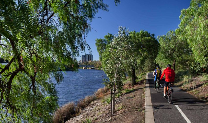
                                     Our pedestrian networks and infrastructure need to be of sufficient
                                     quality to support a growing demand for street space.
                                     We have seen renewed enthusiasm and uptake in cycling, with many
                                     taking advantage of our well-developed, off-road trails that provide
                                     excellent connections. However, we have work to do with our on-road
                                     network in terms of safety and consistent infrastructure to promote
                                     cycling as a safe. efficient and viable transport option.
                                     We will also review speed limits to improve safety for children walking
                                     and cycling to school.
                                     Ridesharing and electric vehicle uptake also play a major role in our
                                     future planning.
                                     On-road public transport – buses and trams – experience the snarls
                                     and congestion associated with inner Melbourne suburbs, and many
                                     of our stations are bustling hubs on the metropolitan train network.
                                     We are working to make public transport an efficient, attractive and
                                     reliable alternative to driving.

                                     While identifying areas to improve Council’s infrastructure and assets,
                                     we’re also working closely with the State Government and private
                                     agencies to provide positive and tangible outcomes for our
                                     community.
                                     Cr Steve Stefanopoulos
                                     Mayor

                                                                                                               Integrated Transport Plan January 2020
CITY OF STONNINGTON

     4                                                                                                                 5
Integrated Transport Plan - CITY OF STONNINGTON
Introduction

                      PURPOSE                                                                                                Figure 1-2: The City of Stonnington
                      The Stonnington Integrated Transport Plan (ITP) sets key directions to guide the
                      future planning and development of the transport system, and support sustainable                                                                    Legend

                                                                                                                                                                              Stonnington boundary                             rail network
                      growth in the municipality over the next five years. It builds on the 2014 transport                                                                    urban area                                       tram network

                      plan1 , to define transport, travel and planning issues for Stonnington, and provides a
                             8
                                                                                                                                                                              industrial precinct                              bus network

                      refreshed five-year plan (within a longer-term framework) for improving travel and                                                                      public open space                                strategic cycling corridor

                      access.
                                                                                                                                                                              health and education precinct                    state significant road corridor

                                                                                                                                                                              major activity centre                            primary road network

                      BACKGROUND
                                                                                                                                                                                   national employment and innovation centre

                      The ITP supports the City of Stonnington Council Plan and its vision for an inclusive,
                      healthy, creative, sustainable and smart community. Transport cuts across the four key
                      pillars: Community, Liveability, Environment and Economy, with strategies to maintain
                      infrastructure and assets, advocate for improved and accessible public transport and
                      facilitate use of sustainable transport options. The ITP supports the delivery of these
                      strategies and complements the City of Stonnington’s Municipal Strategic Statement to
                      provide an integration of land use and transport policy. See Figure 1-1 for how the ITP
                      fits with the Council Plan and other key documents.
                      In 2020, the aspirations of the 2014 ITP and its strategic actions remain relevant.
                      However, in the past five years there has been significant development in the City of
                      Stonnington and the wider Metropolitan area – including strong growth, increasing
                      costs of congestion on both road and public transport, several new metropolitan policy
                      and infrastructure documents, and significant State investment in major new transport
                      infrastructure. The 2020 ITP responds to these developments.
                      The updated plan will guide transport, access and development throughout
                      Stonnington, communicating Council’s vision, goals and strategic actions for the                       CITY OF STONNINGTON                                                                                                     N
                      transport network.                                                                                     The City of Stonnington is located in Melbourne’s inner south east, a short distance
                                                                                                                             from the centre of Melbourne and alongside the Yarra River. The municipality covers an
                      Figure 1-1: How the ITP fits within Council’s planning framework                                       area of just over 25 square kilometres, and takes in the suburbs of Prahran, Windsor,
                                                                                                                             South Yarra, Toorak, Armadale, Malvern, Malvern East, Glen Iris and Kooyong.

                                                      Council Plan 2017 - 2021                                  Vision

                                  Municipal Health
                                                                            Municipal Strategic Statement      Strategy
                                 and Wellbeing Plan

                                                                                                                                                                                                                                                                 Integrated Transport Plan January 2020
                                                   Integrated Transport Strategy

                                                             Action Plans
                                                                                                            Implementation
CITY OF STONNINGTON

                      8 SKM, 2014. Stonnington Integrated Transport Plan

     6                                                                                                                                                                                                                                                                   7
Integrated Transport Plan - CITY OF STONNINGTON
Introduction

                          DEVELOPING THE ITP                                                                                  THE ITP HAS BEEN DEVELOPED IN ACCORDANCE WITH KEY POLICIES
                          The 2020 ITP updates the 2014 ITP, which provided a long-term plan to increase                      AND STRATEGY DOCUMENTS:
                          integration between transport and land use planning. The plan is underpinned by:
                                                                                                                              Figure 1-4: Key policy and strategy documents
                              »    Phase 1 Summary Report, July 2018 – background report containing data
                                   analysis and literature review.
                                                                                                                               State
                              »    Stakeholder engagement – to support the identification of current issues and
                                   anticipated future challenges.
                                                                                                                               Transport Integration Act               Set the strategic policy context, which promotes the
                          This plan should be read in conjunction with the July 2018 background summary                        Plan Melbourne
                                                                                                                                                                       integration of long-term land use, infrastructure and
                                                                                                                                                                       transport planning.
                          report. Competed activities and future steps in the development of the ITP are outlined
                                                                                                                               Victoria’s 30 Year Infrastructure       Outlines the need for world-class infrastructure to drive
                          in Figure 1-3.                                                                                       Strategy & Victorian                    continued economic growth and to cater for population
                                                                                                                               Infrastructure Plan                     growth

                          Figure 1-3: ITP development activities                                                                                                       Emphasis on maximising existing assets.

                                                                                             Council
                                                                Council &
                      Background      Stakeholder     Draft                   Update      Endorsement &           Prepare
                                                               Stakeholder
                        Report        Engagement       ITP                    Draft ITP    Community              Final ITP
                                                                 Review                                                        Metropolitan
                                                                                           Engagement

                                                                                                                               Inner Melbourne Action Plan
                                                                                                                               (IMAP) 2016 –2026                       Collaborative partnerships that set the metropolitan context
                                                                                                                                                                       Include a focus on infrastructure investments and urban
                          POLICY FRAMEWORK                                                                                     Southern Melbourne Regional
                                                                                                                               Development Agency – Regional           consolidation to improve liveability while responding to
                          Council Plan Vision: Stonnington will be an inclusive, healthy, creative,                            Plan                                    rapid growth
                          sustainable and smart community.                                                                     Network Development Plan –              Encourage behaviour change but also outline the need for
                                                                                                                               Metropolitan Rail                       network improvements to aid accessibility and integrate
                                                                                                                                                                       development
                          The City of Stonnington has a number of plans and strategies that contribute to
                          achieving the vision for Stonnington, and guide strategic, statutory, operational and
                          service activities relating to the transport network and travel within Stonnington.
                          These plans include the Public Health and Wellbeing Plan, Municipal Strategic
                          Statement, and strategies and policies for walking, cycling, car share, parking and                  Local
                          road safety.
                          At the State level, the Victorian Government’s legislation and policy framework supports                                                     Set the local policy context.
                          Council and the community to respond to key transport and land use challenges. The                   Council Plan
                                                                                                                                                                       Focus on supporting sustainable, healthy and connected
                          Transport Integration Act 2010 (TIA) is Victoria’s principal transport statute, and                  Municipal Strategic Statement           communities, vibrant local economies and Stonnington’s
                                                                                                                                                                       heritage and natural environment.
                          establishes a framework for the provision of an integrated and sustainable transport                 Municipal Public Health and
                                                                                                                               Wellbeing Plan Council                  Emphasis placed on sustainable transport including
                          system in Victoria. The City of Stonnington and the Victorian Government is required to
                                                                                                                               strategies and plans                    walking, cycling and public transport across the
                          have regard to the objectives and decision-making principles of the TIA:                                                                     municipality.

                                                                                                                                                                                                                                      Integrated Transport Plan January 2020
                              »    Social and economic inclusion
                              »    Economic prosperity
                              »    Environmental sustainability
                              »    Integration of transport and land use
CITY OF STONNINGTON

                              »    Efficiency, coordination and reliability
                              »    Safety, health and wellbeing

     8                                                                                                                                                                                                                                        9
Integrated Transport Plan - CITY OF STONNINGTON
The City of
                      Stonnington

                      LOCAL CONTEXT                                                                           The City of Stonnington has a resident population of over 115,000. The demographic
                      The City of Stonnington is located in Melbourne’s inner south-eastern suburbs,          profile typically varies from west to east, with the western part of the city characterised
                      between three and 13 kilometres south-east of Melbourne’s central business district.    by higher density suburbs (peaking at 93 people per hectare in parts of South Yarra8), a
                      The Stonnington boundary is the Yarra River and Gardeners Creek to the north, Punt      younger average age population and a greater proportion of single and two-person
                      Road to the west, Warrigal Road to the east and Dandenong Road, Princes Highway/        households.
                      Queens Way to the south.                                                                In the eastern suburbs, the population density generally decreases, and dwelling sizes
                      Stonnington takes in the suburbs of Armadale, Kooyong, Malvern, Malvern East,           and the average age of residents increases. These differences generate different travel
                      Prahran, Toorak, and parts of Glen Iris, South Yarra, and Windsor. As illustrated in    demands across the municipality.
                      Figure 2-1, the area is primarily residential, with focal areas for employment and      Some areas of Stonnington are also more accessible than others, which creates
                      tourism, as well as lifestyle precincts and parks.                                      important differences between the western suburbs, which have lower car ownership
                      Prahran/South Yarra, Toorak Village and Malvern/Armadale form key major activity        and greater sustainable transport uptake, and the eastern suburbs, which are more
                      centres, serving as hubs for employment and industry, plus retail precincts for the     dependent on car travel. This can be partly attributed to greater access to transport
                      community. The municipality is also home to Chadstone Shopping Centre, which drives     choice.
                      regional, interstate and international visitation to Stonnington. The city also has a   With continued residential intensification and redevelopment, the Stonnington
                      network of educational establishments and health precincts.                             population is expected to grow to 145,000 by 2036 (refer Figure 2-2). The Forrest Hill
                                                                                                              precinct in South Yarra has accommodated the greatest level of development in recent
                      Figure 2-1: Stonnington land use map                                                    years. It is expected this precinct, and surrounding areas, will continue to face medium
                                                                                                              and high-rise residential pressures over this period with the growth of the Chapel Street
                                                                                                              Activity Centre. Other key sites already undergoing / earmarked for development are
                                                                                                              the Waverley Road Activity Centre, Dandenong Road Precinct, Glenferrie Road / High
                                                                                                              Street Activity Centre and Hawksburn Village.
                                                                                                              By 2036, the number of dwellings in Stonnington is forecast to grow to over 67,000 (an
                                                                                                              increase of nearly 16,000 from 2016), while the average household size is predicted to
                                                                                                              fall to just over two. A rapidly growing population combined with smaller households
                                                                                                              will lead to an increase in the number of trips on the transport network.

                                                                                                                                                                                                                                               Integrated Transport Plan January 2020
CITY OF STONNINGTON

                                                                                                              8 Compared to an average population density of 44 persons per hectare across Stonnington, and neighbouring inner south-eastern
                                                                                                              LGAs (28 persons per hectare in Bayside to 39 in Glen Eira).

10                                                                                                                                                                                                                                                     11
Integrated Transport Plan - CITY OF STONNINGTON
The City of
                                                         Stonnington

                                                         Figure 2-2: Population, household and average household
                                                         size forecasts 2016 to 2036 (Source: .id)

                                                          160,000                                                                                                                                                                   2.5

                                                          140,000
                                                                                                                                                                                                                                    2.0

                                                                                                                                                                                                                                          Average household size (persons)
                      Forecast population / households

                                                          120,000

                                                         1000,000
                                                                                                                                                                                                                                    1.5

                                                           80,000

                                                                                                                                                                                                                                    1.0
                                                           60,000

                                                           40,000
                                                                                                                                                                                                                                    0.5
                                                           20,000

                                                               0                                                                                                                                                                    0
                                                                         2016

                                                                                2017

                                                                                       2018

                                                                                              2013

                                                                                                     2020

                                                                                                            2021

                                                                                                                   2022

                                                                                                                          2023

                                                                                                                                  2024

                                                                                                                                         2025

                                                                                                                                                2026

                                                                                                                                                       2027

                                                                                                                                                              2028

                                                                                                                                                                     2029

                                                                                                                                                                            2030

                                                                                                                                                                                   2031

                                                                                                                                                                                          2032

                                                                                                                                                                                                 2033

                                                                                                                                                                                                        2034

                                                                                                                                                                                                               2035

                                                                                                                                                                                                                      2036

                                                                                                                                                                                                                             2037
                                                                    Total Population                 Households                  Average Household size

                                                         Stonnington is also home to over 17,000 businesses, which support nearly 60,000
                                                         jobs. Retail is the largest industry in terms of employment, followed by the health
                                                         sector. Jobs in these sectors are generally concentrated in the major activity centres
                                                         in the western part of the municipality, with the notable exception of Chadstone
                                                         Shopping Centre in Malvern East. The redevelopment of sites such as Jam Factory,
                                                         Malvern Central and Chadstone, and the growth of education and health precincts,
                                                         are predicted to create an extra 25,000 jobs by 2036.
                                                         With such employment destinations in the municipality, and key destinations in
                                                         neighbouring local authorities, Stonnington is a significant exporter and importer of
                                                         labour. The most recent census information indicates that more than 75 per cent of
                                                         residents commute out of the municipality for work (over 42,500 people). The most
                                                         common outflows are to central Melbourne, while most people working in
                                                         Stonnington travel from neighbouring local authorities to the south and east.
                                                         Travel demand to (and through) Stonnington is likely to be intensified by growth
                                                         outside of Stonnington. The area identified as the Inner South East subregion under
                                                         Plan Melbourne (which includes the local government areas of Bayside, Boroondara,
                                                         Glen Eira and Stonnington) is forecast to grow by 90,000 residents by 2031, with
                                                         further growth in neighbouring subregions in the central area and to the east.

                                                                                                                                                                                                                                                                             Integrated Transport Plan January 2020
                                                         The dense and growing population, demographic make-up, significant commercial
                                                         centres and growing visitor economy present a range of challenges and
                                                         opportunities for transport in Stonnington. Keeping pace and responding to these
                                                         proactively is necessary in delivering a transport network that protects liveability and
CITY OF STONNINGTON

                                                         supports the economy, thereby driving the need for an integrated approach through
                                                         the development of this ITP.

12                                                                                                                                                                                                                                                                                   13
Integrated Transport Plan - CITY OF STONNINGTON
The City of Stonnington

                                                                                                                                                                                                                                                 TOORAK
                                                                                                                                                            SOUTH YARRA                                                                          Home to 12,900 people. Forecast to grow to 15,700 by 2036. Contains the municipality’s highest proportion
                                                                                                                                                                                                                                                 of people aged 65 and over
                                                                                                                                                                TOORAK
                         ALEXAN
                                                                                                                                                                                                                                                 Largely residential, with areas of commercial use and public park land
                                      DRA AV

                                                                           RD
                                                                         GRANGE
                                                                                                                                                                                                                                                 Toorak Village identified as a Major Activity Centre in Plan Melbourne.
                                                TOORAK

                                                                                                                                                                                                                                                 High reliance on the private car; 91% of residents have access to at least one car, 54% drive to work
                                                         RD

                                                                                                                                                                KOOYONG

                                                                                                                                                                                                                                                 Serviced by Heyington Station, which has seen a decline in patronage - 26% decrease between 2008-2014,
                      COMM
                             ERCIAL
                                      RD                                                                                                                        MALVERN                                                                          and Toorak Station

                                                                                                                                                                                                 GLEN IRIS
                                               HIGH ST                                                                                                                                                                                           KOOYONG
                                        ST
                                      CHAPEL

                                                                RD

                                                                                                                                                                                                                                                 Home to 800 people
                                                                            RD
                                                              WILLIAMS

                                                                                           RD
                                                                          ORRONG

                                                                                                       RD
                                                                                         KOOYONG

                                                                                                   GLENFERRIE

                                                                                                                                                                                                                                                 Lowest population density of less than 20 persons per hectare Contains a high proportion of people aged 65
                                                                                                                                                                                                                                                 and over
                                                                                                                          WATTLETR
                                                                                                                                     EE RD

                                                                                                                                                                                                                                                 Contains residential areas, neighbourhood precincts and open space
                      PRAHRAN - WINDSOR
                                                                                                                  GA RD

                                                                                                                                                                                                                        MALVERN EAST
                                                                                                                TOORON

                                                                                                                                                                                                                                                 High reliance on the private car; 96% of residents have access to at least one car, 54% drive to work

                                                                                                                                              RD
                                                                                                                                             BURKE

                                                                                                                                                                                                MO
                                                                                                                                                                                  M

                                                                                                                                                                                                NA
                                                                                                                                                                                  AL
                                                                                   ARMADALE
                                                                                                                                                                                                                                                 Bounded by the Monash Freeway, with access via Toorak Road – generates high levels of through traffic

                                                                                                                                                                                      VE

                                                                                                                                                                                                 SH

                                                                                                                                                                                                                                         L RD
                                                                                                                                                                                      RN

                                                                                                                                                                                                      FW
                                                                                                                                                                                           RD

                                                                                                                                                                                                                                       WARRIGA
                                                                                                                                                                                                        Y
                                                                                                                                                     WATTLETR
                                                                                                                                                                EE RD

                                                                                                                                                                                                                                                 ARMADALE
                                                                                                                                                                          RD

                                                                                                                                                                                                       ONE RD
                                                                                                                                                                        DARLING

                                                                                                                                                                                                     CHADST
                                                                                                                                                                                                                                                 Home to 9,100 people. Forecast to grow to 11,900 by 2036.
                                                                                                                                                                                                                WAV
                                                                                                                                                                                                                      ERLE
                                                                                                                                                                                                                             Y RD

                                                                                                                                                                                                                                                 High job numbers centred on the main shopping strips. Additional 5,000 jobs forecast by 2036.

                                                                                                                                                                                                                                                 Malvern/Armadale identified as a Major Activity Centre in Plan Melbourne

                                                                                                                                                                                                                                                 Competing demands on local and arterial roads causes safety concerns. Traffic congestion also undermines
                                                                                                                                                                                                                                                 the operation of trams and buses, particularly along Malvern Road and High Street
                       SOUTH YARRA
                        Home to 20,700 people. Stonnington’s fastest-growing suburb. Forecast population of 33,400 by 2036.
                                                                                                                                                                                                                                                 MALVERN
                        High population density >90 persons per hectare. High proportions of lone households / young couples                                                                                                                     Home to 10,200 people
                        without children.
                                                                                                                                                                                                                                                 Contains residential, commercial, civic/educational and hospital land uses (Cabrini Hospital) and open
                        Prahran/South Yarra identified as a Major Activity Centre in Plan Melbourne.                                                                                                                                             space. Malvern/Armadale identified as a Major Activity Centre in Plan Melbourne

                        Significant employment growth forecast, with additional 6,300 jobs by 2036. Key sites: Jam Factory                                                                                                                       Competing demands on local and arterial roads causes safety concerns. Traffic congestion also undermines
                        redevelopment (reopening in 2020). However, high outflows to central Melbourne for work (over 5,000                                                                                                                      the operation of trams and buses, particularly along Malvern Road and High Street.
                        residents).
                                                                                                                                                                                                                                                 Malvern tram depot located on Glenferrie Road. Significant patronage growth on Tram Route 5,
                        Greater sustainable transport uptake. 26% do not have access to a car. 37% use public transport to work                                                                                                                  Malvern- Melbourne University, grew by 120 per cent in the 10 years to 2016/17.
                        and 17% commute by active transport

                        Chapel Street suffers from competing demands, reported as one of the top ten locations for crashes                                                                                                                       MALVERN EAST
                        involving cyclists in Melbourne
                                                                                                                                                                                                                                                 Home to 21,700 people, including a large number of families and young people. Forecast to grow to 29,900
                        South Yarra Station caters for over 35,000 passengers daily                                                                                                                                                              residents by 2036.

                                                                                                                                                                                                                                                 Key residential development sites: Waverley Road Activity Centre, Dandenong Road Precinct development
                                                                                                                                                                                                                                                 and infill development.
                       PRAHRAN - WINDSOR                                                                                                                                                                                                         Chadstone Shopping Centre, employs over 5,000 workers and attracts over 20 million visitors each year.
                        Home to 19,700 people. Forecast to grow to 26,500 by 2036.
                                                                                                                                                                                                                                                 Also contains Holmesglen TAFE as a signficant employer and a number of schools.

                                                                                                                                                                                                                                                                                                                                                              Integrated Transport Plan January 2020
                        Prahran/South Yarra identified as a Major Activity Centre in Plan Melbourne.
                                                                                                                                                                                                                                                 High reliance on the private car; 90% of residents have access to at least one car and 58% drive to work.
                        High job numbers centred on the main shopping strips. Additional 5,000 jobs forecast by 2036. However,                                                                                                                   Higher proportions of rail station access by car
                        high outflows to central Melbourne for work (over 4,000 residents).
                                                                                                                                                                                                                                                 Stonnington and central Melbourne popular work destinations, followed by Monash
                        Greater sustainable transport uptake. 20% do not have access to a car. 32% use public transport to work
                        and 10% commute by active transport
CITY OF STONNINGTON

                                                                                                                                                                                                                                                 GLEN IRIS
                        Chapel Street suffers from competing demands, reported as one of the top ten locations for crashes
                                                                                                                                                                                                                                                 Home to 9,300 people. Forecast to grow to 11,800 by 2036
                        involving cyclists in Melbourne
                                                                                                                                                                                                                                                 Contains residential areas, neighbourhood precincts and schools
                        Significant patronage growth on Tram Route 78, Balaclava-North Richmond, grew by 80 per cent in the 10
                        years to 2016/
                                                                                                                                                                                                                                                 High reliance on the private car; 90% of residents have at least one car, 55% drive to work
                        South Yarra Station caters for over 35,000 passengers daily
                                                                                                                                                                                                                                                 Bounded by the Monash Freeway, with access via Burke Road and High Street – generates high levels of
                                                                                                                                                                                                                                                 through traffic.

14                                                                                                                                                                                                                                                                                                                                                                    15
Integrated Transport Plan - CITY OF STONNINGTON
The City of
                      Stonnington

                      Key transport challenge
                                                                                                                      A growing population
                      MANAGING GROWTH
                      Strong population and employment growth is forecast within Stonnington
                      through to 2036. In conjunction with growth outside of the municipality, it is                  145,000
                      estimated that Stonnington will need to cater for an additional 180,000 trips to,               2036 projected residential populations
                      from and within the municipality (a 25 per cent increase from 2016).
                      Population growth will vary significantly across Stonnington’s neighbourhoods, creating
                      localised impacts and challenges. South Yarra and Malvern East are expected to
                                                                                                                                        26%
                                                                                                                                        2016 to 2036
                      accommodate much of the forecast population growth through medium and high-rise
                      residential and infill development. Absorbing additional travel demand associated with
                      land use intensification will be challenging. If not managed effectively, local road
                      congestion and public transport overcrowding during peak periods could undermine
                      resident’s quality of life, as well as Stonnington’s ability to effectively manage the       Figure 2-4: Method of travel to work (Source: ABS, 2011 and 2016)
                      impacts of growth.
                                                                                                                                         2016
                      In addition to a growing resident population, the number of visitors to Stonnington for
                      work, shopping and leisure is expected to increase. This will emphasise the need to                       16%
                      invest in improved linkages to key attractors such as the Melbourne CBD, activity
                                                                                                                                  17%
                      centres and Chadstone Shopping Centre, particularly by more-space efficient and                                                            Private car trips
                                                                                                                                         2011
                      sustainable forms of travel.                                                                    7%                                         Public transport trips
                                                                                                                           6%
                      For the majority of trips within Stonnington, the private car is the dominant transport        3%    2%
                                                                                                                                                        46%      Other trips
                      mode (refer Figure 2-4), This can be attributed to factors such as the lack of viable                                       49%
                                                                                                                                                                 Cycling trips
                      public transport options; the number of motor vehicles available in a household; and
                      the travel distance to work. A clear exception are the western suburbs, where the                         26%                              Walking trips

                      majority of trips to work are by non-car modes.                                                      28%

                      Pressure across the Stonnington transport network is likely to be intensified by growth
                      in through traffic, or trips without an origin or destination within the municipality. Key
                      developments near the municipal boundary include the Cremorne and Church Street
                      South major employment precinct and the expansion of Monash University (Caulfield).          The figure shows 46 per cent of working residents commute by car (as drivers or
                      With a young, growing population, improving access to education, employment and              passengers). While this is on a downward trend, population growth has meant an
                      other services will be increasingly important.                                               additional 1,400 Stonnington residents are commuting to work by car compared to
                                                                                                                   2011.
                                                                                                                   Journey to work figures also indicate an increased uptake in public transport,
                                                                                                                   particularly by train with an increase of nearly 2,900 trips between 2011 and 2016.
                                                                                                                   Commuting by foot and bicycle has also increased with 10 per cent of residents now

                                                                                                                                                                                                              Integrated Transport Plan January 2020
                                                                                                                   actively commuting to work.
                                                                                                                   In addition, 61 per cent of trips to work in Stonnington are by car or motorcycle. Much
                                                                                                                   of this is from areas south and east of Stonnington, where public transport services are
                                                                                                                   much less extensive.
CITY OF STONNINGTON

16                                                                                                                                                                                                                    17
Integrated Transport Plan - CITY OF STONNINGTON
The City of
                      Stonnington

                      Key transport challenge
                      CREATING SPACE FOR PEDESTRIANS
                      Walking is an important means of transport in Stonnington, with over 4,000
                      residents walking to work in 2016 (seven per cent of journeys to work), in addition
                      to trips for education, shopping and recreation. Walking also forms a key
                      component of other active, public transport and private vehicle journeys. At rail
                      stations in Stonnington, over two thirds of passengers arrive on foot.
                      Stonnington has a comprehensive pedestrian network due to extensive work to create
                      high quality streets. The growth
                      in jobs, population and visitors, however, mean that footpaths are becoming
                      overcrowded in key locations, putting people at risk and affecting the performance of
                      Stonnington’s activity centres. These include parts of Chapel Street, where alfresco
                      dining and street clutter can reduce walkable widths, and parts of Toorak Road, which
                      are narrower than normally observed, as well as busy interchanges, which highlight the
                      important interaction between walking and public transport use.
                      The volume and proximity of vehicle traffic and a lack of suitable and convenient
                      crossing opportunities on the arterial road network can also act as a deterrent to
                      pedestrians. Crashes involving pedestrians in recent years have been concentrated on
                      the main arterial roads and through the key activity centres.
                      To improve conditions for pedestrians, a bolder approach to providing pedestrian
                      priority and changing the way space is used in the municipality is required.

                         The most important mode
                         4,000
                         residents walked to work in 2016

                                     37%

                                                                                                               Integrated Transport Plan January 2020
                                     increase in residents walking
                                     to work over the last 20 years
CITY OF STONNINGTON

18                                                                                                                     19
The City of
                      Stonnington

                      Key transport challenge
                      GETTING MORE PEOPLE CYCLING
                      Stonnington has a network of off-road trails and on- road bicycle lanes that
                      provide a range of opportunities to cycle within and through the municipality.
                      2.7 per cent of Stonnington residents cycled to work in 2016. This is lower than
                      neighbouring inner-city municipality’s8, however, suggests significant scope to
                      increase cycling for short trips to school, work or the shops.
                      While the off-road trail network is well developed and provides direct connections into
                      the CBD, there are challenges with providing safe cycle infrastructure on much of
                      Stonnington’s road network. This has resulted in an on-street network which is
                      relatively sparse and poorly connected.
                      Cyclist safety is also an area of concern. Over 300 crashes have involved cyclists in the
                      municipality over the past five years9. Key issues are associated with areas of high
                      traffic volumes and the high turnover of on-street parking. Chapel Street is regularly
                      reported as one of the top ten locations for crashes involving cyclists in Melbourne.
                      Cycle parking provision varies across Stonnington. While Council works have
                      significantly increased the provision of leaning rails (ground mounted) and pole vault
                      style (street sign mounted) parking facilities in key end of trip locations, nearly half of
                      the train stations in Stonnington still do not have cycle parking facilities (neither hoops
                      or parkiteer cages).

                           Safety and confidence issues
                           323
                           crashes have involved cyclists in the
                           municipality over the past five years

                                              2.7%
                                              of residents cycled

                                                                                                                                                    Integrated Transport Plan January 2020
                                              to work in 2016.
                                              (1% increase since 2006)
CITY OF STONNINGTON

                      8 City of Port Phillip at 4.5 per cent, and City of Yarra at 8.6 per cent.
                      9 VicRoads, 2019. Crash Statistics https://www.vicroads.vic.gov.au/safety-and-road-rules/safety-statistics/crash-statistics

20                                                                                                                                                          21
The City of
                      Stonnington

                      Key transport challenge                                                                     Public transport is an important mode of travel to, from and within Stonnington,
                                                                                                                  particularly for journeys to work. However, during peak times, many services are
                                                                                                                  already heavily loaded as they enter Stonnington, with passenger benchmarks
                      IMPROVING THE ACCESSIBILITY AND ATTRACTIVENESS                                              regularly exceeded on Dandenong and Frankston corridor services and key tram
                      OF PUBLIC TRANSPORT                                                                         routes8. This prevents more people from travelling by public transport.
                      As illustrated in Figure 2-5, Stonnington is well serviced by public transport. With five   Key projects like the Metro Tunnel will help support passenger demand, however, the
                      train lines across 15 stations, nine tram routes and 24 bus routes, the majority of         capacity of the rail network is forecast to become constrained again soon after
                      Stonnington residents are within 400 metres of at least one public transport route.         completion. Patronage growth will also impact the operation of and user experience at
                      Despite such an extensive network, service frequency reduces across the municipality        stations, with increasing numbers of people boarding, alighting and transferring
                      (west to east) and, in many instances, the vehicles and infrastructure fall short of        between services. South Yarra station is already one of the busiest stations outside the
                      meeting community needs.                                                                    City Loop9. Prahran, Windsor and Malvern are also popular stations, with over 3,000
                                                                                                                  entries per weekday.
                      Figure 2-5: Public transport in and around Stonnington (Source: PTV)                        On-road public transport reliability is a key issue across Melbourne, with buses and
                                                                                                                  trams often suffering from congestion and delays where there is no on-road priority.
                                                                                                                  With the exception of Dandenong Road, all tram and bus routes in Stonnington share
                                                                                                                  space with traffic on roads, making them some the slowest in Melbourne.
                                                                                                                  Tram speeds average just 16km/h across the network, with lows of 12km/h on routes
                                                                                                                  such as the 7810. Insufficient separation also makes passenger access difficult and
                                                                                                                  hazardous. Serious casualty crashes predominate along Stonnington’s tram routes.
                                                                                                                  Infrequent services also discourage people from using public transport. Many of the
                                                                                                                  bus routes in Stonnington only operate a 30-minute service and, in general, there is
                                                                                                                  little or no coordination of bus and train timetables. Service frequencies further reduce
                                                                                                                  outside of peak periods and at the weekend. This is generally not suitable or
                                                                                                                  convenient for commuters or leisure travellers.

                                                                                                                                                                                                                                                       Integrated Transport Plan January 2020
CITY OF STONNINGTON

                                                                                                                  8 DoT, 2019. Passenger Load Surveys. https://transport.vic.gov.au/about/data-and-research/passenger-load-surveys
                                                                                                                  9 City of Stonnington, 2016. South Yarra Station Patronage https://www.stonnington.vic.gov.au/files/sharedassets/public/documents/
                                                                                                                  south-yarra- station-patronage-19-april-2016.pdf
                                                                                                                  10 City of Stonnington, 2018. Stonnington Public Transport Advocacy: Reference Document https://www.stonnington.vic.gov.au/files/
                                                                                                                  assets/public/vision/advocacy/public-transport-advocacy_web.pdf

22                                                                                                                                                                                                                                                             23
The City of
                       Stonnington

                       Key transport challenge
                       NETWORK CAPACITY AND CONGESTION
                       Roads in Stonnington serve a multitude of functions, including catering for
                       distribution, local access, public transport, cycling and walking, on-street
                       parking, as well as forming places in their own right. In conjunction with current
                       travel patterns – where nearly 70 per cent of daily movements are by private car
                       (refer Figure 2-6) – this can lead to a range of competing demands, routine
                       congestion and road safety issues.
                       Infrastructure Victoria has identified the City of Stonnington as one of the top two
                       municipalities in Melbourne for road unreliability and a number of roads, such as Toorak
                       Road and High Street, as at peak traffic capacity during commuting periods. Increasing
                       levels of congestion and delay on connecting roads, such as Punt Road, can also have
                       knock-on effects. People find sitting in traffic stressful, inconvenient and unreliable. It
                       can also introduce costs in time and fuel, reduce freight efficiency, and contribute to
                       carbon emissions and air pollution.
                       There are also a number of external factors contributing to demand on the Stonnington
                       network. Stonnington is used as a thoroughfare for those living in southern and eastern
                       suburbs to access inner Melbourne. This places significant stress on the arterial road
                       network, which can have knock-on impacts on the local network. Over 30 per cent of
                       traffic on Malvern Road, Wattletree Road, Darling Road and Belgrave Road is through
                       traffic. This can contribute to congestion, impact urban amenity and impede public
                       transport, walking and cycling, without contributing directly to the productivity of the
                       municipality.
                       Private vehicles (cars) will continue to be the dominant mode for people to access the
                       municipality, and for private and work-related travel. Given existing levels of congestion,
                       and the limited capacity to continue to cater for increasing numbers of vehicles on the
                       roads, a shift in travel decisions to more sustainable modes will be important. As
                       shown on Figure 2-5 below, a high proportion of short trips (under 5km) are by private
                       vehicles.

                       Figure 2-6: Main mode of transport used by Stonnington residents by distance
                       (Source: VISTA 2014-2016)t

                                        70,000

                                        60,000

                                                                                                                     Integrated Transport Plan January 2020
                                        50,000

                      Number of trips
                                        40,000

                                        30,000
CITY OF STONNINGTON

                                        20,000

                                        10,000

                                            0
                                                 0-5km               5-10km            10-15km   15-20km   >20km

                                                  Private   Public            Active   Other

24                                                                                                                           25
The City of
                          Stonnington

                          Figure 2-7: Traffic composition - daily weekday volumes
                          (Source: VISTA 2012-2016, OpenRouteService)

                      1                                                    4

                                                              2

                                                                   3
                                                   1
                                                                                               5

                               N

                               0-1km

                                Through Traffic

                                Incoming / Outgoing Traffic
                                                                                           5
                                Internal Traffic

                                        Increasing demands on bounding roads can have knock-on
                           1
                                        effects on roads across the municipality.

                                        Malvern Road, Toorak Road, Williams Road, High Street, and
                           2
                                        Waverly Road serve high volumes of incoming/outgoing traffic.

                                        Other arterial and local routes provide local access to
                           3
                                        destinations within Stonnington. Key areas include Glenferrie
                                        Road/High Street Activity Centre, Chadstone and Chapel
                                        Street retail precinct.

                                                                                                        Integrated Transport Plan January 2020
                                        Toorak Road provides the last access before the City Link
                           4
                                        tunnel, which can encourage rat-running through Stonnington.

                                        Monash Freeway and the main arterial roads (particularly Punt
                           5
CITY OF STONNINGTON

                                        Road, Dandenong Road, Warrigal Road and Toorak Road)
                                        carry significant volumes of through traffic.

26                                                                                                              27
The City of
                      Stonnington

                      Key transport challenge
                      TECHNOLOGICAL CHANGE
                      The digital age is advancing, with new forms of communication and
                      technological possibilities that have the potential to significantly alter
                      how and why we travel.
                      Rapid advances in technology are increasing the options available for sustainable
                      mobility as well as offering network safety and efficiency benefits, including car and
                      bike share schemes, ride-sourcing applications (such as Uber, Taxify, Hola, etc) and
                      automated vehicles in the future. The further integration between emerging mobility
                      services also has the potential to contribute to the greater personalisation of transport,
                      and the emergence of ‘Mobility as a Service’.
                      The degree of uncertainty around the uptake rate and complexity of social and
                      technological change presents considerable challenges for transport. There will be an
                      increasing need for flexibility and adaptability within the transport system to harness
                      technological benefits and proactive regulation/policy making to address issues such
                      as safety, data security, competition between public and private modes, etc.

                                                                                                                   Integrated Transport Plan January 2020
CITY OF STONNINGTON

28                                                                                                                         29
A vision for
                      Stonnington

                      VISION

                      “The City of Stonnington is serviced by
                      a transport network that supports an
                      inclusive, healthy, creative, sustainable
                      and smart community.”

                      STRATEGIC PRIORITIES
                      The next five years holds the opportunity for Stonnington to further improve the quality
                      of life for people living in, working in and visiting the municipality. Transport plays a
                      critical role in delivering the changes needed. The challenge for the ITP is to identify
                      where future investment should be targeted for maximum impact towards achieving
                      economic, social and environmental aspirations.
                      Key objectives of the ITP provide a focus for transport investment in Stonnington for the
                      next five years and beyond. They build on the strategic actions of the 2014 ITP to meet
                      future transport challenges, and support wider policy and strategic directions.
                         »   To integrate transport and land use planning to maximise accessibility, safety
                             and sustainability of the transport network and the built environment.
                         »   To create an active transport network that is connected, integrated, safe and
                             accessible. One that encourages more people to walk and cycle more often.
                         »   To facilitate an increase in the use of public transport by making these options
                             as accessible, safe, convenient and attractive as possible.
                         »   To increase the safety and efficiency of Stonnington’s roads for all users.
                         »   To encourage a reduced reliance on parking provision in new developments
                             where appropriately located.

                      These objectives represent the most important aspects of the ITP and outline the areas
                      in which the City of Stonnington’s advocacy and actions will be concentrated.
                      Key actions identified throughout the ITP help meet one or more of these objectives,
                      which in turn contribute to realising the vision for the municipality. Actions have been
                      developed for Stonnington’s ‘Western’, ‘Central’ and ‘Eastern’ suburbs. The intent is to
                      ensure actions are area focused and reflect of the different characteristics across the

                                                                                                                   Integrated Transport Plan January 2020
                      municipality. A summary of these areas is contained in Figure 3-1.
                      Further analysis, key priorities and actions for each of the areas is provided in sections
                      four to six of the ITP. Overarching strategic and advocacy actions, common to each of
CITY OF STONNINGTON

                      the areas, is provided in section seven.

30                                                                                                                         31
A vision for
                                               Stonnington

                                               Figure 3-1: Stonnington’s ‘Western’, ‘Central’ and ‘Eastern’ Suburbs
                                               and key characteristics

                                                                                                                                                                                                                                                       Stonnington’s ‘Western’ Suburbs
                                                                                                                                                                                                                                                       Characterised by:
                         ALEXAND
                                       RA AV

                                                                                                                                                                                                                                                       » High density residential and commercial area
                                                                              RD
                                                                            GRANGE

                                                   TOORAK
                                                            RD
                                                                                      TOORAK
                                                                                                                                                                                                                                                       » Young and growing population
                               SOUTH YARRA                                                                      KOOYONG
                                                                                                                                                                                                                                                       » Significant employment growth
                      COMM
                             ERCIAL
                                      RD                                                                                                                                                                                                               » Lower car ownership
                                                 PRAHRAN                                                                                                                                                                                               » High active and sustainable transport use
                                                  HIGH ST
                                                                                       ARMADALE
                                        ST
                                      CHAPEL

                                                                    RD

                                                                                                                                      GLEN IRIS
                                                WINDSOR
                                                                               RD
                                                                 WILLIAMS

                                                                                            RD
                                                                             ORRONG

                                                                                                       E RD
                                                                                          KOOYONG

                                                                                                    GLENFERRI

                                                                                                                MALVERN

                                                                                                                                    WATTLETR
                                                                                                                                               EE RD
                                                                                                                            GA RD

                                                                                                                                          MALVERN EAST

                                                                                                                                                                                                                                                       Stonnington’s ‘Central’ Suburbs
                                 ‘Western’ Suburbs
                                                                                                                          TOORON

                                                                                                                                                        RD
                                                                                                                                                       BURKE

                                  ‘Central’ Suburbs
                                                                                                                                                                                                          MO
                                                                                                                                                                                            M

                                                                                                                                                                                                          NA
                                                                                                                                                                                            AL
                                                                                                                                                                                                VE

                                                                                                                                                                                                           SH

                                                                                                                                                                                                                                               L RD
                                                                                                                                                                                                RN

                                                                                                                                                                                                                FW

                                                                                                                                                                                                                                                       Characterised by:
                                                                                                                                                                                                     RD

                                  ‘Eastern’ Suburbs

                                                                                                                                                                                                                                             WARRIGA
                                                                                                                                                                                                                   Y

                                                                                                                                                               WATTLETR
                                                                                                                                                                          EE RD
                                                                                                                                                                                    RD

                                                                                                                                                                                                                                                       » Lower density, largely residential with areas of commercial land use
                                                                                                                                                                                                                 NE RD
                                                                                                                                                                                  DARLING

                                                                                                                                                                                                               CHADSTO

                                                                                                                                                                                                                         WAV
                                                                                                                                                                                                                               ERLE
                                                                                                                                                                                                                                      Y RD
                                                                                                                                                                                                                                                       » Higher median age, high proportions of over 60’s
                                                                                                                                                                                                                                                       » High car ownership
                                                                                                                                                                                                                                                       » Lower active and sustainable transport use

                                                                                                                                                                                                                                                       Stonnington’s ‘Eastern’ Suburbs
                                                                                                                                                                                                                                                       Characterised by:

                                                                                                                                                                                                                                                                                                                                Integrated Transport Plan January 2020
                                                                                                                                                                                                                                                       » Low residential density
                                                                                                                                                                                                                                                       » Large number of families and young people
CITY OF STONNINGTON

                                                                                                                                                                                                                                                       » Significant employment and education clusters
                                                                                                                                                                                                                                                       » High car ownership
                                                                                                                                                                                                                                                       » Lower active and sustainable transport use

32                                                                                                                                                                                                                                                                                                                                      33
A vision for
                      Stonnington

                      To achieve sustainable network goals, the road user hierarchy set out in Figure 3-2 has
                      been adopted. The hierarchy aligns with current policy and strategy approaches, and
                      recognises the movement and resource efficiency of different modes of transport.

                      Figure 3-2: Overarching road user hierarchy

                      Movement                                                                             Resource
                      Efficiency                                     Walking                               Efficiency

                                                                     Cycling

                                                                 Public Transport

                                           Commercial vehicles serving local businesses and institutions

                                                            Single-occupancy vehicles

                                                                                                                        Integrated Transport Plan January 2020
CITY OF STONNINGTON

34                                                                                                                              35
Stonnington’s
                      Western Suburbs

                      OVERVIEW
                                                                                                                                                                                                                                                      KEY CHARACTERISTICS

                                                                                                                                                                                                                                                                      Home to over 40,000 residents, forecast to increase to over
                              ALEXANDR
                                             A AV
                                                                                                                                                                                                                                                                      58,000 by 2036 Young population, 36% aged 25-34 years

                                                                                      RD
                                                                                    GRANGE
                                                                                              TOORAK                                                                                                                                                                  High proportion of lone households / young couples without
                                                           TOORAK
                                                                    RD
                                                                                                                                                                                                                                                                      children. High population density, up to 98 persons per
                                                                                                                       KOOYONG                                                                                                                                        hectare in South Yarra
                                    SOUTH YARRA

                          COMMER
                                   CIAL RD
                                                                                                                                                                                                                                                                      Contains > 22,000 jobs, forecast to increase by > 11,000
                                                                                                                                                                                                                                                                      additional jobs by 2036
                                                         PRAHRAN

                                                          HIGH ST
                                                                                               ARMADALE                                                                                                                                                               Low car ownership, approximately 20% do not have access
                        WINDSOR
                                                    ST

                                                                                                                                           GLEN IRIS                                                                                                                  to a car
                                                CHAPEL

                                                                           RD

                                                                                       RD
                                                                         WILLIAMS

                                                                                                    RD
                                                                                     ORRONG

                                                                                                              IE RD
                                                                                                  KOOYONG

                                                                                                            GLENFERR

                                                                                                                       MALVERN                                                                                                                                        Greater sustainable transport uptake, 35% use public
                                                                                                                                                                                                                                                                      transport, 4% cycle and 12% walk to work.
                      Stonnington’s western suburbs are South Yarra, Prahran and Windsor, bounded
                                                                                                WATTLE
                                                                                                      by    the
                                                                                                       TREE RD

                      Yarra River to the north, Punt Road to the west and Dandenong Road to the south.
                                                                                                                                   GA RD

                                                                                                                                             MALVERN EAST
                                                                                                                                 TOORON

                      The area captures high density residential and retail precincts, and educational                                             RD

                      establishments. Prahran/South Yarra forms a key major activity centre and
                                                                                                                                                  BURKE

                                                                                                                                                                                                     MO
                                                                                                                                                                                       M

                                                                                                                                                                                                     NA
                                                                                                                                                                                       AL
                      encompasses the Chapel Street retail and services–based precinct. This forms a hub

                                                                                                                                                                                           VE

                                                                                                                                                                                                      SH

                                                                                                                                                                                                                                              L RD
                                                                                                                                                                                           RN

                                                                                                                                                                                                           FW
                      for the local community, workers and visitors.

                                                                                                                                                                                                RD

                                                                                                                                                                                                                                            WARRIGA
                                                                                                                                                                                                             Y
                                                                                                                                                          WATTLE
                                                                                                                                                                   TREE RD                                                                            COMMITTED PROJECTS
                      The suburbs lie less than five kilometres from the CBD. This draws large outflows of
                      residents for work. The area benefits from high levels of accessibility and is well-
                                                                                                                                                                               RD

                                                                                                                                                                                                            ONE RD
                                                                                                                                                                             DARLING

                      serviced by public transport options. A younger demographic profile combined with                                                                                                                                                               Metro Tunnel and duplication of the Cranbourne line will
                                                                                                                                                                                                          CHADST
                      technological advances (including a growth in car sharing and ride share apps), has                                                                                                                                                             increase capacity on rail lines through Stonnington. The
                                                                                                                                                                                                                     WAV
                      contributed to reducing levels of car ownership and growing sustainable transport use.
                                                                                                                                                                                                                           ERL
                                                                                                                                                                                                                                 EY R
                                                                                                                                                                                                                                        D                             Metro Tunnel is on track to be completed by 2025. Planning
                                                                                                                                                                                                                                                                      is underway for the Cranbourne line duplication.
                      The capacity and performance of the public transport network is a growing concern.
                      Road based travel remains a predominant mode for the incoming workforce and for
                      servicing local businesses.                                                                                                                                                                                                                     South Yarra Station redevelopment will deliver a wider
                                                                                                                                                                                                                                                                      entrance on Toorak Road and fully accessible tram stops,
                                                                                                                                                                                                                                                                      enabling easier transfers. Expected to be delivered by 2020.

                                                                                                                                                                                                                                                                                                                                     Integrated Transport Plan January 2020
                                                                                                                                                                                                                                                                      Streamlining Hoddle Street will introduce innovative
                                                                                                                                                                                                                                                                      intersection designs and new technology at Brunton Avenue
                                                                                                                                                                                                                                                                      and Swan Street to make journeys easier and safer.
CITY OF STONNINGTON

36                                                                                                                                                                                                                                                                                                                                           37
Stonnington’s
                      Western Suburbs

                       TRANSPORT CHALLENGES                                                               TRANSPORT CHALLENGES

                       High-density development and demands on street space                               Access to public transport services
                       Stonnington’s western suburbs remain the fastest growing in the municipality.      Stonnington’s western suburbs contain some of the busiest public transport
                       They will continue to face high- rise development pressures, growing               stops and interchanges. In addition to overcrowding on services (which
                       population densities and employment and visitor growth, all of which will          prevents more people from using them), access to stops and interchanges is
                       increase demand for travel. This will place pressure on public space, streets      a growing issue. Poor integration with the street environment and other
                       and the transport system, exacerbating areas of footpath overcrowding,             transport modes, accessibility and capacity are undermining the user
                       capacity issues at high-demand train stations and on already popular tram          experience and could discourage people from using public transport.
                       routes, road traffic congestion and parking pressures. In such areas of
                       increasing residential density, there will be a strong need for high amenity       Competing demands for street space and network efficiency
                       spaces and a more efficient use of street space. This will involve prioritising
                       more efficient forms of transport, including public transport, walking, cycling    Stonnington’s streets typically provide for multiple modes of transport, local
                       and rideshare, and reallocating road space to support the increasing daily         access, on-street parking as well as serving place functions, which leads to
                       population. It is acknowledged that trips by private vehicles are less efficient   competing demands across the network, contributing to congestion, safety
                       compared to other modes, and the use of street space for on-street parking         and access issues.
                       benefits a fraction of the people living, working and visiting such areas.         The anticipated population growth in Stonnington’s west, together with a
                                                                                                          growing workforce and business needs, will increase the number of people
                       Cycle safety                                                                       and trips accommodated by the network. Given the limited street space, a
                                                                                                          new approach is required to accommodate such increases in demand. The
                       Cycling is an increasingly important choice of transport. It takes pressure
                                                                                                          challenge will lie in determining which uses should be prioritised to best
                       off the public transport system, reduces congestion and noise and is
                                                                                                          meet the needs of Stonnington’s west. It will be important to consider the
                       non-polluting. More people on bikes means a more active and healthier
                                                                                                          movement and place functions of the network.
                       population who are able to enjoy a cleaner and less congested city. Safety
                       (and perception of safety), is a key barrier.
                       The primary north-south on-road cycle route in Stonnington is along Chapel
                       Street. Chapel Street is an area of very high activity with a range of
                       competing demands for on-road space. As a result, space for cyclists is
                       limited and in close proximity to on-street car parking bays. In combination
                       with traffic volumes and the high turnover of parking, this has contributed to
                       a relatively high level of car dooring incidents, and concentration of crashes
                       causing injury to cyclists. Chapel Street is regularly reported as one of the
                       top ten locations for crashes involving cyclists in Melbourne.

                                                                                                                                                                                           Integrated Transport Plan January 2020
CITY OF STONNINGTON

38                                                                                                                                                                                                 39
Stonnington’s
                      Western Suburbs

                      RESPONSE – STRATEGIES AND ACTIONS
                      Stonnington’s west requires a suite of strategies to manage growth pressures, that              ACTIONS
                      consider the balance of development, changes to local character, services, traffic and
                                                                                                                      Review use of street space
                      transport access (including improved pedestrian and cycling opportunities and
                      parking and servicing impacts).                                                                 W3    Identify a pedestrian priority network for the highest level of pedestrian facilities/
                                                                                                                            services (such as through the Chapel Street Precinct and public transport hubs).
                                                                                                                            Deliver priority measures to reduce overcrowding. These should consider: widening
                      Priorities for transport in Stonnington’s west include:                                               footways, reducing crossing distances, minimising waiting times at signalised
                                                                                                                            crossings, converting laneways into shared zones with lower speed limits, etc.

                        CHALLENGE                       RESPONSE                                                      W4    Consider establishing design and development overlays in priority areas (such as near
                                                                                                                            activity centres) to support the creation of new walking and cycling links.
                       High-density development         »   Continue to promote development and intensity of          W5    Reduce street clutter to address footpath crowding issues (particularly in activity
                       and demands on street space          activity around high- quality sustainable transport.            centres and around public transport hubs), including reviewing the Footpath Trading
                                                        »   Review use of street space, prioritising pedestrian             and Awnings Policy to provide appropriate design standards and enforcement
                                                            movement, cycle safety and accessible public space,             practices.
                                                            while retaining servicing access.

                       Cycle safety                     »   Develop safer streets for cyclists.
                                                                                                                      Develop safer streets for cyclists
                                                                                                                      W6    Undertake a review of local roads with a record of serious cycle crashes and
                       Access to public transport       »   Address capacity and access issues at public transport
                                                                                                                            implement measures to reduce identified risks. Chapel Street will be a key priority.
                       services                             hubs. Upgrade pedestrian networks ensuring pathways
                                                            between key origins and destinations prioritise safety,   W7    Review speed limits where appropriate, with a priority focus on popular cycle routes.
                                                            space, connectivity and meet best practice standards.
                                                                                                                      W8    Work with schools to provide walking and cycling priority access at key entrances.
                       Competing demands for            »   Identify network objectives and priorities to manage            This could include separate walking and cycling facilities from vehicles or additional
                       street space and network             competing demands.                                              crossing points to improve accessibility by foot and bicycle. Prahran High School
                       efficiency                       »   Encourage the use of more sustainable, space-efficient          would be a good pilot study.
                                                            modes of travel (including walking, cycling, public
                                                            transport and car-share) and reduce the number of         Address capacity and access issues at public transport hubs
                                                            non-essential vehicle trips.
                                                        »   Maintain access for emergency vehicles, deliveries and          Support and contribute to the South Yarra Station redevelopment to facilitate local
                                                            servicing. Promote the productive use of kerbside lanes         access, DDA compliance and improved service provision.
                                                            (e.g. retention of short-term parking and on-street
                                                            loading bays where appropriate and encouraging                  Advocate for further station upgrades in line with the recommendations of State
                                                            servicing out of hours to minimise disruption).                 Government Station Access Plans. High demand rail stations (such as Prahran and
                                                                                                                            Windsor) form a priority

                                                                                                                      Manage competing demands and improve network efficiency
                                                                                                                      W11   Work with State Government and other relevant stakeholders to identify network and
                                                                                                                            mode priorities. Priority areas include:
                                                                                                                            » Chapel Street, with consideration of Chapel St ReVison Structure Plan (including
                        ACTIONS                                                                                                Jam Factory redevelopment)
                                                                                                                            » Toorak Road, with the redevelopment of South Yarra Station and fully accessible
                        Continue to promote development around high-quality sustainable                                        tram stops
                        transport                                                                                           » Punt Road, in consultation with State Government and City of Melbourne

                                                                                                                      W12   Review and reform on-street car parking to maximise the efficient use of street space,

                                                                                                                                                                                                                     Integrated Transport Plan January 2020
                       W1     Encourage the development of transit-oriented development at key public transport
                                                                                                                            optimise deliveries and servicing, and maintain access for those who need it. Key
                              hubs, including railway stations. Support the development of the South Yarra Station
                                                                                                                            considerations should include: areas for road space reallocation, management options
                              precinct masterplan.
                                                                                                                            for areas of high demand (such as time restrictions and pricing structures), making
                       W2     Work with neighbouring LGAs to understand the impacts and access requirements of              more efficient use of on-street loading, and the role of taxi ranks.
                              major development sites outside Stonnington, and encourage the planning and
CITY OF STONNINGTON

                                                                                                                      W13   Identify further locations for convenient car share spaces in accordance with Council
                              development of sustainable transport connections. Key areas include the Cremorne
                                                                                                                            policy.
                              and Church Street South major employment precinct.
                                                                                                                      W14   Update the resident parking permit scheme to better manage and allocate parking
                                                                                                                            provision in activity centres and areas with good public transport access.

40                                                                                                                                                                                                                           41
Stonnington’s
                                                                      Central Suburbs

                                                                      OVERVIEW
                                                                                                                                                                                                                                                                    KEY CHARACTERISTICS

                           ALEXAND
                                      RA AV                                                                                                                                                                                                                                         Home to over 33,000 residents, forecast to increase to
                                                                                 RD

                                                                                                                                                                                                                                                                                    approximately 42,000 by 2036. Older demographic profile,
                                                                               GRANGE

                                                                                            TOORAK                                                                                                                                                                                  19% aged 35 to 49 years, 27% over 60 years
                                                     TOORAK
                                                              RD

                                                                                                                         KOOYONG
                                 SOUTH YARRA

                                                                                                                                                                                                                                                                                    High proportions of older couples without children
                       COMMER
                                CIAL RD

                                                   PRAHRAN

                                                    HIGH ST
                                                                                                                                                                                                                                                                                    Lower population density, low of 20 persons per hectare in
                                                                                             ARMADALE
                      WINDSOR                                                                                                                                                                                                                                                       Kooyong Contains >16,000 jobs, forecast to increase by
                                              ST

                                                                                                                                               GLEN IRIS
                                          CHAPEL

                                                                                                                                                                                                                                                                                    >7,000 additional jobs by 2036
                                                                     RD

                                                                                ORRONG RD
                                                                   WILLIAMS

                                                                                                KOOYONG RD

                                                                                                                E RD
                                                                                                             GLENFERRI

                                                                                                                         MALVERN
                                                                                                                                                                                                                                                                                    High car ownership, approx. 90% have access to one or
                                                                                                                                             WATTLE
                                                                                                                                                      TREE RD
                                                                                                                                                                                                                                                                                    more vehicles
                                                                                                                                     GA RD

                                                                                                                                                      MALVERN EAST
                                                                                                                                   TOORON

                                                                                                                                                                                                                                                                                    Lower sustainable transport uptake, 24% use public
                                                                                                                                                                 RD

                                                                                                                                                                                                                                                                                    transport, 2% cycle and 4% walk to work.
                                                                                                                                                                BURKE

                                                                                                                                                                                                                   MO
                                                                                                                                                                                                     M

                                                                                                                                                                                                                   NA
                                                                                                                                                                                                     AL
                                                                                                                                                                                                         VE

                                                                                                                                                                                                                    SH

                                                                                                                                                                                                                                                            AL RD
                                                                                                                                                                                                         RN

                                                                                                                                                                                                                         FW
                                                                                                                                                                                                              RD

                                                                                                                                                                                                                           Y

                                                                                                                                                                                                                                                          WARRIG
                                                                                                                                                                        WATTLE
                                                                                                                                                                                 TREE RD

                                                                      Stonnington’s central suburbs are Toorak, Armadale, Malvern and Kooyong, bounded
                                                                                                                                                                                             RD

                                                                                                                                                                                                                          ONE RD
                                                                                                                                                                                           DARLING

                                                                      by the Monash Freeway to the north, Dandenong Road to the south and Williams Road
                                                                                                                                                                                                                        CHADST

                                                                      and Tooronga Road between the western and eastern suburbs.                                                                                                   WAV
                                                                                                                                                                                                                                         ERL
                                                                                                                                                                                                                                               EY R
                                                                                                                                                                                                                                                      D

                                                                      The area captures lower density residential precincts, with areas of commercial land                                                                                                          COMMITTED PROJECTS
                                                                      use (largely centred on the main shopping strips), civic, health and educational
                                                                      establishments. Malvern/Armadale and Toorak Village are identified as Major Activity
                                                                                                                                                                                                                                                                                    The Victorian Government Budget 2018/19 provided $3
                                                                      Centres in Plan Melbourne, providing a suburban focal point for services, employment,
                                                                                                                                                                                                                                                                                    million for design and planning works to begin on a new
                                                                      housing, public transport and social interaction.
                                                                                                                                                                                                                                                                                    tram route to connect Caulfield and Rowville.
                                                                      Employment and population growth is forecast to be more moderate, however areas
                                                                                                                                                                                                                                                                                    There is also a $475 million Federal commitment to Monash
                                                                      such as Malvern Central and the Dandenong Road entry form strategic development
                                                                                                                                                                                                                                                                                    Rail (Caulfield to Rowville), advocating a heavy rail option.
                                                                      sites.
                                                                      The area is characterised by an older demographic profile, with higher proportions of                                                                                                                         Toorak Road level crossing removal in Kooyong is currently
                                                                      those aged over 60 years. There are increasing levels of car ownership and use. In                                                                                                                            under development. Its removal will address congestion on
                                                                      conjunction with high levels of though traffic this has significant impacts on network

                                                                                                                                                                                                                                                                                                                                                    Integrated Transport Plan January 2020
                                                                                                                                                                                                                                                                                    Toorak Road, and improve safety for drivers and
                                                                      efficiency and the performance (and attractiveness) of more sustainable modes.                                                                                                                                pedestrians.
CITY OF STONNINGTON

42                                                                                                                                                                                                                                                                                                                                                          43
Stonnington’s
                      Central Suburbs

                       TRANSPORT CHALLENGES                                                                                                          TRANSPORT CHALLENGES

                       Congestion                                                                                                                    Pedestrian accessibility
                       Congestion is already a key issue on parts of the network. Within the central                                                 The volume of motor traffic and lack of suitable and convenient crossing
                       suburbs, this congestion is intensified by increasing private vehicle use, greater                                            opportunities on the arterial road network can act as a barrier to pedestrians
                       levels of through-traffic and pinch points on the network.                                                                    and cyclists. This has particular impacts on road safety and accessibility to
                                                                                                                                                     Stonnington’s major activity centres. Crashes involving pedestrians and cyclists
                       Congested conditions impact the performance and attractiveness of alternative
                                                                                                                                                     in recent years have been concentrated on the main arterial roads and through
                       modes with trams and buses subject to similar delays where there is no
                                                                                                                                                     the key retail areas.
                       dedicated infrastructure. Roads such as High Street and Toorak Road are a
                       particular source of frustration for motorists and public transport users, and                                                There are also areas across the central suburbs where the walking
                       have been identified as at capacity8. Congestion costs metropolitan Melbourne                                                 environment deteriorates. In general, the walking environment of station
                       in the order of $4.6 billion per year, this is forecast to rise to $10.2 billion by                                           precincts is poor, exacerbated by footpath quality, limited crossing facilities and
                       20309.                                                                                                                        poor transfer between modes. The minor retail areas in the neighbourhood
                                                                                                                                                     centres also tend to have less pedestrian friendly environments.
                       Impacts of through-traffic
                       Many people who drive through Stonnington are passing through with
                                                                                                                                                     On-street parking
                       business elsewhere. Toorak Road, Glenferrie Road and Malvern Road are three                                                   Car parking is often identified as an issue in need of addressing. Parking
                       of the primary streets in the municipality used as thoroughfares, with between                                                pressures have been highlighted throughout the development of the Draft
                       30-50 per cent of vehicles on these roads through-traffic. Toorak Road, in                                                    Activity Centres Strategy and Precinct Structure Plans, with increasing demand
                       particular, provides the last off-ramp for traffic before the City Link tunnel; travel                                        for on-street parking identified. This adds to congestion, as people search for
                       west of Toorak Road towards the CBD is tolled, which can further encourage                                                    spaces, and can place pressure on surrounding residential streets for parking.
                       rat-running through Stonnington. Traffic congestion on arterial routes can lead
                       to traffic filtering through residential areas as drivers attempt to bypass peak-
                       period traffic queues. High proportions of through-traffic are also observed on
                       Wattletree Road and Orrong Road.
                       Through-traffic can contribute to congestion, impact urban amenity and local
                       access, and impede public transport, walking and cycling, without contributing
                       directly to the productivity of the municipality.

                       8 Infrastructure Victoria, 2018. Five-Year Focus Immediate actions to tackle congestion. http://www.infrastructurevictoria.
                       com.au/wp- content/uploads/2019/04/WEB-VERSION-Five-Year-Focus-Immediate-actions-to-tackle-congestion-
                       April-20181.pdf
                       9 Bureau of Infrastructure, Transport and Regional Economics (BITRE), 2015. Traffic and congestion cost trends for
                       Australian capital cities https://bitre.gov.au/publications/2015/files/is_074.pdf

                                                                                                                                                                                                                                           Integrated Transport Plan January 2020
CITY OF STONNINGTON

44                                                                                                                                                                                                                                                 45
You can also read