Land measurement for planning and development purposes - Global 1st edition, May 2021
←
→
Page content transcription
If your browser does not render page correctly, please read the page content below
GUIDANCE NOTE

          Land measurement for
          planning and development
          purposes
          Global
          1st edition, May 2021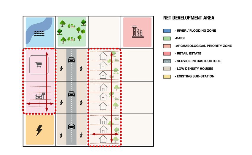
i
IP

     LAND MEASUREMENT
     FOR PLANNING AND
     DEVELOPMENT PURPOSES

     RICS guidance note, global
     1st edition, May 2021

     Effective from 24 August 2021

     Copyright acknowledgement

     Figures 1–5 graphics © FAL, reprinted with permission.

     Table 3 is reproduced with the kind permission of Ordnance Survey.

     Published by the Royal Institution of Chartered Surveyors (RICS)

     Parliament Square

     London

     SW1P 3AD

     www.rics.org

     No responsibility for loss or damage caused to any person acting or refraining
     from action as a result of the material included in this publication can be
     accepted by the authors or RICS.

     ISBN 978 1 78321 423 5

     © Royal Institution of Chartered Surveyors (RICS) May 2021. Copyright in
     all or part of this publication rests with RICS. Save where and to the extent
     expressly permitted within this document, no part of this work may be
     reproduced or used in any form or by any means including graphic, electronic,
     or mechanical, including photocopying, recording, taping or web distribution,
     without the written permission of RICS or in line with the rules of an existing
     licence.

     Typeset using Typefi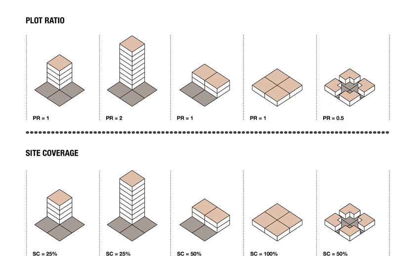
ii
  IP

                           Contents
                           Acknowledgments ������������������������������������������������������������������ iv
                           RICS professional standards and guidance �������������������������� 1
                               RICS guidance notes ����������������������������������������������������������������������� 1
                           Glossary ������������������������������������������������������������������������������������ 3
                           1 Introduction ������������������������������������������������������������������������� 4
                               1.1 Overview ���������������������������������������������������������������������������������� 4
                               1.2 Land measurement within national institutional
                                   frameworks ���������������������������������������������������������������������������� 5
                               1.3 Focus ��������������������������������������������������������������������������������������� 6
                               1.4 Unit of measurement ������������������������������������������������������������ 6
                               1.5 Core definitions ����������������������������������������������������������������������� 7
                               1.6 Effective date ��������������������������������������������������������������������������� 7
                           2 Key issues with the measurement of development land
                             ������������������������������������������������������������������������������������������������ 8
                               2.1 Definitions ������������������������������������������������������������������������������� 8
                               2.2 Land and property boundaries �������������������������������������������� 9
                               2.3 Measurement method and medium ���������������������������������� 10
                               2.4 Inspection ������������������������������������������������������������������������������ 11
                           3 Application of key measurements ��������������������������������� 12
                               3.1 Land ownership area (LOA) ������������������������������������������������� 12
                               3.2 Site area (SA) ������������������������������������������������������������������������� 14
                               3.3 Net development area (NDA) ���������������������������������������������� 16
                               3.4 Density measurements: plot ratio (floor area ratio/
                                   floorspace ratio) and site coverage ������������������������������������ 18
                           4 Factors affecting measurement calculations ���������������� 21
                               4.1 The blue line area: land ownership in the context of SA/
                                   NDA ���������������������������������������������������������������������������������������� 21
                               4.2 Density ����������������������������������������������������������������������������������� 21
                               4.3 Open space ���������������������������������������������������������������������������� 23
                               4.4 Sustainable drainage systems (SuDS) �������������������������������� 24
                           5 Measurement of land ‘as constructed’ �������������������������� 25
                               5.1 Plans as constructed ������������������������������������������������������������ 25

LAND MEASUREMENT FOR PLANNING AND DEVELOPMENT PURPOSES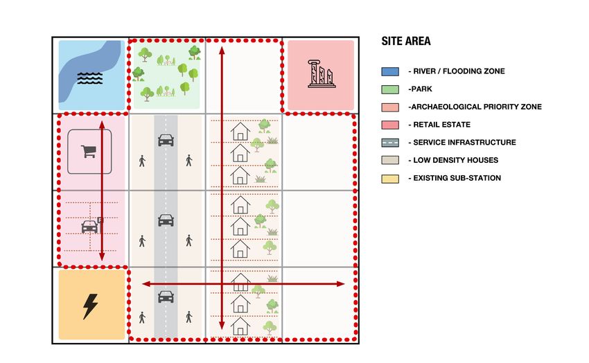
iii
  IP

                           6 Application for planning and development purposes �� 26
                              6.1 Planning and development process ����������������������������������� 26
                              6.2 Time ���������������������������������������������������������������������������������������� 28
                           Appendix A: Survey accuracy banding �������������������������������� 29
                           Appendix B: Ordnance Survey mapping ����������������������������� 30
                           Appendix C: Supplementary glossary ��������������������������������� 32

LAND MEASUREMENT FOR PLANNING AND DEVELOPMENT PURPOSES
iv
  IP

                           Acknowledgments
                           Lead author

                           Jonathan Manns FRICS (Rockwell, UCL)

                           Working group

                           Chair: Paul Collins FRICS (Nottingham Trent University)

                           Chris Balch MRICS (University of Plymouth)

                           Richard Blyth (Royal Town Planning Institute)

                           Nick Francis (FAL Architects)

                           Alan Gunne-Jones (Planning & Development Associates)

                           James Muldowney (Barrister)

                           Anthony Shapland MRICS (Colliers International)

                           Ian Sutton MRICS (CBRE)

                           Andrew Taylor MRICS (Taylor Wimpey)

                           RICS standards lead

                           Tony Mulhall MRICS

                           Standards delivery project manager

                           Helvi Cranfield

                           Editor

                           Sam Birch

                           An earlier version of this guidance note was reviewed by Roy Pinnock,
                           Solicitor (Dentons).

                           We are also grateful to Martha Grekos, Barrister, and Meeta Kaur, Solicitor
                           (Town Legal), for their comments.

                           During the course of our consultation, we received many valuable
                           submissions from the sector, which were greatly appreciated.

LAND MEASUREMENT FOR PLANNING AND DEVELOPMENT PURPOSES
1
IP
RICS professional standards and
guidance
RICS guidance notes
Definition and scope
RICS guidance notes set out good practice for RICS members and for firms that are regulated by RICS. An
RICS guidance note is a professional or personal standard for the purposes of RICS Rules of Conduct.
Guidance notes constitute areas of professional, behavioural competence and/or good practice. RICS
recognises that there may be exceptional circumstances in which it is appropriate for a member to depart
from these provisions – in such situations RICS may require the member to justify their decisions and
actions.
Application of these provisions in legal or disciplinary proceedings
In regulatory or disciplinary proceedings, RICS will take account of relevant guidance notes in deciding
whether a member acted professionally, appropriately and with reasonable competence. It is also likely
that during any legal proceedings a judge, adjudicator or equivalent will take RICS guidance notes into
account.
RICS recognises that there may be legislative requirements or regional, national or international standards
that take precedence over an RICS guidance note.
LAND MEASUREMENT FOR PLANNING AND DEVELOPMENT PURPOSES2
IP
Document status defined
The following table shows the categories of RICS professional content and their definitions.
Publications status
Type of document Definition
RICS Rules of Conduct for Members and RICS Rules of These Rules set out the standards of professional
Conduct for Firms conduct and practice expected of members and
firms registered for regulation by RICS.
International standard High-level standard developed in collaboration with
other relevant bodies.
RICS professional statement (PS) Mandatory requirements for RICS members and
RICS regulated firms.
RICS guidance note (GN) A document that provides users with
recommendations or an approach for accepted
good practice as followed by competent and
conscientious practitioners.
RICS code of practice (CoP) A document developed in collaboration with other
professional bodies and stakeholders that will have
the status of a professional statement or guidance
note.
RICS jurisdiction guide (JG) This provides relevant local market information
associated with an RICS international standard or
RICS professional statement. This will include local
legislation, associations and professional bodies
as well as any other useful information that will
help a user understand the local requirements
connected with the standard or statement. This
is not guidance or best practice material, but
rather information to support adoption and
implementation of the standard or statement
locally.
LAND MEASUREMENT FOR PLANNING AND DEVELOPMENT PURPOSES3
IP
Glossary
This glossary defines terms that relate to the core purpose of this guidance. A supplementary glossary
appears at the end of this guidance note, which defines terms in more general use.
Density Density is measured on either a gross or net basis, and for residential schemes can
be expressed in various ways, including dwellings per hectare/acre, habitable rooms
per hectare/acre or bedspaces per hectare/acre. Plot ratio, floor area ratio, floorspace
ratio and site coverage are also expressions of density that can be applied to all uses,
but are most appropriately used for commercial premises. Density should always
be expressed in terms of gross areas (based on site area), while net density can
provide an additional measure to assist with the interpretation and assessment of the
intensity of a development.
Gross density Gross density is a measure that includes all aspects of a site of any size, including the
housing, commercial space, roads, open and public realm, schools and their grounds,
and other uses. It is calculated using site area.
Land Land ownership area is an area of land, measured on a horizontal plane, which is
ownership held in a single legal interest or title by one or more legal owners, and that may
area (LOA) be the subject of a proposed or actual sale, letting or other disposal, valuation or
compulsory purchase. It may comprise all or part of that single legal interest or title.
Net density Net density is a measure that includes everything that is developed but excludes
major roads, open and public realm, schools and their grounds, and commercial and
community buildings. It is calculated using net development area.
Net Net development area is the extent of the site area upon which one or more buildings
development or other operations and their ancillary space can be built, measured on a horizontal
area (NDA) plane.
Plot ratio (PR) Plot ratio is the ratio of total development floor area to site area. Development floor
area may be measured as gross external area (GEA) or gross internal area (GIA),
but whichever is used – or modifications of them – should be clearly stated. Gross
external area and gross internal area are defined in Property measurement, RICS
professional statement.
Floor area ratio (FAR) and floorspace ratio (FSR) are similar terms.
Site area (SA) Site area is the total land area for which development authorisation is sought,
measured on a horizontal plane.
Site coverage Site coverage is the ratio of ground floor area (measured on the basis of GEA) to site
(SC) area.
LAND MEASUREMENT FOR PLANNING AND DEVELOPMENT PURPOSES4
IP
1 Introduction
This section sets out the context in which this guidance has been prepared and published, in addition to
making clear the scope of the guidance.
1.1 Overview
RICS acts globally to promote and enforce the highest international standards in the valuation,
management and development of land, real estate, construction and infrastructure. This guidance note
provides advice on the measurement of land areas for planning and development purposes. It provides
clarity and consistency on such matters for built environment professionals and other stakeholders by
enabling accurate descriptions and assessments of the size of a development site at all stages of the
development process.
It identifies five principal measurements that apply in planning and development practice. These form the
core definitions of this guidance, which should be used wherever possible:
• Land ownership area (LOA)
• Site area (SA)
• Net development area (NDA)
• Plot ratio (PR) and
• Site coverage (SC).
Land ownership area is a new term; the other four terms are in regular use. This guidance note also
acknowledges that these terms will relate to other metrics that are used in certain contexts for assessing
the intensity of use and which, where used, should be reported alongside the appropriate core definition.
These are floor area ratio (FAR) and floorspace ratio (FSR).
The publication of this guidance note remedies a historical lack of clarity and consistency in the way that
land is measured and described for development purposes. It should be read in a cross-disciplinary
context. The intention is that it will be applied across all built environment professions (including surveying,
planning, architecture, engineering and related disciplines). This will allow development sites and proposals
to be accurately compared and assessed, in addition to providing reassurance on such matters to wider
stakeholders and the general public.
This guidance note is intended for use globally. It therefore recognises that planning and development
regimes differ between nations and regions; some are prescriptive, while others are more discretionary in
the implementation of policy objectives. Some jurisdictions will have large areas of unregistered land. The
way in which this guidance note is applied will depend on the nature of each property and the purpose of
each measurement, in addition to the jurisdictional and regulatory context in which the measurement is
being undertaken. While this guidance note should be applied consistently, there will be instances where
professional judgement and/or negotiation are required. In these instances, any divergence should be
made explicit in client reports.
LAND MEASUREMENT FOR PLANNING AND DEVELOPMENT PURPOSES5
IP
This guidance note:
• defines four terms that are used in practice, but for which there has historically been no consistent
definition
• introduces a new term, land ownership area, to ensure clarity about the extent of ownership within
development sites and distinguish this from site area
• clarifies the relationship between land ownership area, site area, net development area, plot ratio and
site coverage, and
• expands technical advice on conducting spatial measurement, marking out or recording land for
professionals such as land surveyors and civil engineers.
The guidance applies equally to both smaller-scale and larger-scale land measurements. This is therefore
relevant to both applications for permission to develop and the allocation/zoning of land in development
plans.
It also applies to all forms of development property and at all stages in the development process. This
reflects the need for RICS members to measure land and calculate areas for a variety of purposes at
different stages of preparing a development proposal, particularly on larger projects. Responsible RICS
members should:
• obtain clear instructions on the purpose of the measurement and
• perform their role and report in a transparent and consistent manner, with regard to both this
guidance note and any appropriate legal, regulatory or other authoritative requirements in the relevant
jurisdiction.
1.2 Land measurement within national institutional frameworks
International development and planning contexts vary, including variations in national land information
systems, which may affect how legal interests and titles in land are verified. In most countries, the legal
registration of land title is carried out through a cadastral system. This records details of:
• ownership
• tenure
• precise location and demarcation
• dimensions
• area and
• the value of individual land parcels.
Other forms of land information system include land registries, such as in the UK and Ireland, which
primarily record details of land title. The information recorded and protection provided through these
systems varies by jurisdiction. There are also locations where land may be in communal ownership, or may
not be registered in a formal sense.
Regulation of new development also varies by country. It is usually administered through a planning
system, the functions of which operate with varying degrees of negotiation and prescription. Different
degrees of approval are also needed before development can start.
There are, however, elements that are common to most planning systems. The development process
starts with an initial assessment of the development potential of an area of land. This progresses to an
LAND MEASUREMENT FOR PLANNING AND DEVELOPMENT PURPOSES6
IP
application for planning permission/a development permit or similar approval on a defined SA. When this
is finally obtained, it fixes the NDA for a particular scheme (see section 5).
1.3 Focus
This guidance note focuses on the measurement of the surface area of land on a horizontal plane. All
defined areas are therefore to be measured on a horizontal plane. Some approaches rely in part on
measures (most commonly gross external area, gross internal area or net internal area as appropriate)
already defined in the Property measurement RICS professional statement, which focuses on the
measurement of floorspace within buildings. This guidance note should be read in conjunction with that
professional statement. Together they provide a comprehensive approach to the measurement of land
and buildings that complies with and supports the International Land Measurement Standard (ILMS).
The consistent application of this guidance note is intended to ensure both commonality across fields of
surveying (measurement, valuation, planning and development, sale and purchase, etc.) and conformity
with the objectives of the relevant planning or development regulatory system. As such, it provides a basis
for land measurement for land acquisition, planning applications, development viability appraisal and the
valuation of development land.
All measurements should be undertaken as accurately as possible in the context of the information
available. Where assumptions are required in relation to the NDA, these should be made as accurately
as possible and be clearly stated. It is recognised that in practice NDA measurement will become more
refined as more information about the scheme becomes fixed and more precise information becomes
available.
It is also recognised that in some situations, particularly for constrained sites, the different measurement
definitions contained in this guidance note may correlate closely or exactly, while in other circumstances
there will be clearer distinctions. Such circumstances will depend on the nature and context of the sites
being measured. The provision of complete and consistent reporting will make any such differences clear.
1.4 Unit of measurement
This guidance note focuses on the approach to measurement and therefore does not specify a required
unit of measurement. The unit of measurement to be adopted must comply with local jurisdictional legal
requirements and local market practice. All formal documents should report in the system required by the
jurisdiction in which they are produced.
It is recognised that, in some circumstances, jurisdictional requirements operate alongside market
conventions. For example, it is common in some nations for professionals to use both imperial and metric
units to report the size of property. The jurisdictional standard should be used in all circumstances.
However, where conventions exist and the nature of reporting allows, both measurements should be
reported for completeness.
LAND MEASUREMENT FOR PLANNING AND DEVELOPMENT PURPOSES7
IP
1.5 Core definitions
This guidance note contains five technical core definitions:
• land ownership area (LOA)
• site area (SA)
• net development area (NDA)
• site coverage (SC) and
• plot ratio (PR).
RICS members should:
• use these terms unless there is a mandatory alternative jurisdictional requirement
• use land ownership area, as defined in this guidance note, to describe the land being dealt with and/or
under consideration, which may consist of either a single land parcel or several different land parcels
(and therefore may concern one or more land ownership areas)
• identify when a potential development site comprises land parcels in different legal ownerships and
therefore within different land ownership areas. In such instances the RICS member should make this
clear when reporting and set out the land ownership areas, and the nature of the legal interests within
the individual parcels and the whole development site.
See section 3 for definitions.
1.6 Effective date
This guidance note is effective three months from the date of publication.
LAND MEASUREMENT FOR PLANNING AND DEVELOPMENT PURPOSES8
IP
2 Key issues with the measurement
of development land
This section sets out the key issues associated with the measurement of development land and provides
guidance on how these should be addressed.
2.1 Definitions
This guidance note introduces global standards to clarify the current situation and rectify historical
inaccuracies, conflations and scope for misrepresentation. An example is that land identified as being
suitable for development is often described as ‘the site’, irrespective of whether the matter in question is
the land ownership area or site area. Land being sold or promoted for development can often be referred
to as ‘the property’, within which 'development land' may be identified in sale or promotion agreements as
the land on which development is sought/approved by a specific permission. The seller's ownership (the
property) may be less or more than the site. This guidance note refers to land ownership area and site
area as distinct from one another, and in distinguishing between ownership interests and development
sites, relies upon the following the measurements.
• Land ownership area (LOA): an area of land, measured on a horizontal plane, which is held in a single
legal interest or title by one or more legal owners, which may be the subject of a proposed or actual
sale, letting or other disposal, valuation or compulsory purchase, and which may comprise all or part of
that single legal interest or title.
• Site area (SA): the total land area on which development authorisation is sought, measured on a
horizontal plane.
• Net development area (NDA): the extent of the site area upon which one or more buildings or other
operations and their ancillary space can be built, measured on a horizontal plane.
It is recognised that certain sectors of the surveying/planning professions also adopt different spatial
metrics for measuring the intensity of development on a particular site. Plot ratio (PR), floor area ratio
(FAR), floorspace ratio (FSR) and site coverage (SC) are commonly used around the world to assist in the
assessment of density. Commercial developers working within planning systems that zone and allocate
land often use SC and PR to provide an indicator of scale, bulk and intensity of use. Of the terms that are
most commonly used, these two should be the preferred metrics in all circumstances and always reported
upon if alternatives are to be used as well:
• Plot ratio (PR): the ratio of total development floor area to SA. Development floor area may be
measured as gross external area (GEA) or gross internal area (GIA) but whichever is used – or
modifications of them – should be clearly stated. Floor area ratio (FAR) and floorspace ratio (FSR) are
similar terms, used interchangeably in some jurisdictions to reference the same point. For consistency,
PR should be used wherever possible. Where jurisdictional requirements are for the use of either FAR
or FSR, PR should be reported as well.
• Site coverage (SC): the ratio of ground floor area (measured in accordance with GEA) to SA, expressed
as a percentage.
LAND MEASUREMENT FOR PLANNING AND DEVELOPMENT PURPOSES9
IP
Prescriptive planning regimes (such as in parts of Europe and the USA), particularly those that adopt a
zoning approach to the identification of land for development, tend to have greater certainty about what
is developable early in the process. In discretionary planning systems, certainty about what is developable
tends to be determined much later in the process, following a period of negotiation and consultation. In
instances where there is a degree of discretion, RICS members should advise their clients on the need for
the ongoing review of measurements, particularly those that impact on the NDA, recognising the potential
impact on land option agreements and land valuation.
2.2 Land and property boundaries
The exact location of the boundary line may be critical to the ability to carry out a development.
All countries operate national systems of land registration as an element of functioning land administration
systems. Most operate a form of cadastre (fiscal, measured, taxation or multipurpose for example). These
typically record boundary information that show the extent of the land holding in question, including
registered burdens. The UK operates a ‘general boundary’ system; more in-depth information on this
can be found in Boundaries: procedures for boundary identification, demarcation and dispute
resolution, RICS guidance note. Although such records provide a useful indication of the extent of a title,
it should be noted that they are not always definitive and not all burdens may be shown in such registers.
There is scope for error and dispute in relation to the interpretation of boundaries, particularly where
assumptions are made without a legal basis or that are not clear. It is advisable to engage, at an early
stage, an RICS member who is a boundary expert. RICS members should ensure that the following are
clearly stated when (1) undertaking calculations at the initial feasibility stage (when detailed land boundary
information may not be available) or (2) reporting on SA and all relevant LOAs at any stage:
• assumptions about the location of the boundary
• the basis for those assumptions
• the limitations of any registration system relied upon (e.g. the extent to which registered title plans are
legally definitive versus indicative, subject to survey), and
• the limitations of reliance on documentary evidence alone, without site inspection or a topographical
survey.
The recommendations in this guidance note assume that:
• all documented boundaries provided to the RICS member are accurate, as evidenced by their source,
and
• the source and its limits have been identified for the RICS member by the professional providing the
boundary information.
RICS members should consider whether additional legal assurance is required to confirm that this
assumption is sound (or whether a topographical survey may be required).
A topographical survey plan will show the physical features of the land in detail and the boundaries
of the site as they are on the ground. It is silent on legal title. If there is real doubt about the validity
or conclusiveness of the available legal documentary evidence, which could materially impact on
measurement or assumptions about the extent of LOAs relative to SA, RICS members should seek
appropriate clarification. It is recognised that where disputes occur there will normally be courses of legal
remedy or dispute resolution available.
LAND MEASUREMENT FOR PLANNING AND DEVELOPMENT PURPOSES10 IP 2.3 Measurement method and medium RICS members (or other professionals who use this guidance note) should make clear the purpose of the measurement and the means by which it has been undertaken (for appraisal, valuation, planning, etc.). This will depend on the nature of the instruction and the stage in the planning and development cycle. The appropriate basis of measurement, which will influence both the method of measurement and level of accuracy required (see Appendix A), will depend on the purpose for which the measurement is being used, for example: • preliminary inquiries • acquisition/sale, compulsory acquisition or option agreement • development phasing • planning application • portfolio management or • valuation. These may have different accuracy requirements, and some of these purposes may be supported by legacy documentation held in a variety of formats and at different scales. Mixing and matching of inappropriate maps, plans, drawings, aerial photos, web-sourced geographic information and surveys can cause serious issues during and after the development process. It is advised that ‘definitive’ mapping information – as provided by national cadastre/mapping agencies – should be sourced as a primary base for further survey and increased spatial accuracy based on project need. Measurements can be produced with a high degree of accuracy as standard for almost all purposes (Appendix A). Where clients provide LOA information in a particular format, for example paper title, the RICS member should form an independent judgment on the provenance of the information and its reliability for the purpose for which it is being used. Older methods of spatial measurement by physical means and paper-based recording are increasingly being superseded by digital capture and reproduction formats. Nevertheless, there will be instances where these remain the most appropriate and it is acknowledged that in some jurisdictions much documentary evidence about land is still held in paper format. In some cases, paper map-based information may have been converted to digital format through digitisation. RICS members should be aware of the potential for inaccuracies arising from such conversions and caveat their advice accordingly. Some of the possible sources of information on LOA are as follows: • paper map • digital map • title plan • cadastral plan • electronic document • geographic information system (GIS)-based map • measured survey-based document and • drone-based survey. LAND MEASUREMENT FOR PLANNING AND DEVELOPMENT PURPOSES
11
IP
An RICS member relying on the measurement should report on the:
• basis on which the measurement was carried out
• appropriateness of such basis
• accuracy of such measurement for the purpose for which it is, or is likely, to be used and
• limitations of using it for a different purpose.
2.4 Inspection
RICS members should:
• wherever feasible, carry out a physical inspection of the LOAs when advising on land measurements for
planning and development purposes
• not normally give advice on the matter without having inspected the LOAs, unless the instruction is
clearly for desktop analysis (or there are other exceptional circumstances that prevent a site from being
appraised in person)
• state when reporting:
– whether the land area has been inspected in person (and the level of inspection conducted)
– if no land inspection has been carried out, why and what the limitations of the advice are as a
result, and
– whether the official register of land ownership has been inspected (in the UK for example, this will
be up-to-date HM Land Registry office copy entries), and if so, any inconsistencies observed.
• be aware of the risk of offering advice where they have not carried out a site inspection, or have not
had a report on title available, and should both caveat their advice accordingly and ensure that its
limitations are clear to those entitled to rely on it.
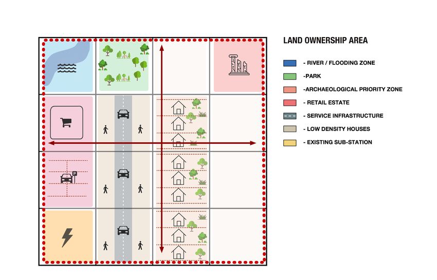
LAND MEASUREMENT FOR PLANNING AND DEVELOPMENT PURPOSES12 IP 3 Application of key measurements This section sets out how the definitions for the measurement of land for planning and development purposes are applied. It provides context to assist with calculation and considers each in terms of its purpose and description, in addition to any specific inclusions and exclusions. Where there is a dispute over the specifics of a particular calculation, negotiations should reflect the ‘spirit’ of the measurement in the context of its purpose. As has been made clear elsewhere in this guidance note, all measurements of land are those of surface area on a horizontal plane. It is common practice for measurement boundaries to be illustrated on plans. It is typical to use a red line for such situations. There will be instances where documents prepared for different purposes both use a red line to delineate the site boundary (e.g. title documents and development application documents). What the red line relates to should be clear from the measurement being presented. However, in the event that different measurements are overlaid on the same plan, different colours should be used, and these should be clearly labelled (e.g. a blue line to represent the LOA on SA drawings for planning purposes). It is recognised that different jurisdictions may have different requirements for the legal land title necessary to submit a valid application for development. Some may require sufficient title to be able to carry out the development, while others may have no such requirements with regard to land title. Also, there may be off-site implications that will need to be addressed, which would have similar implications. In circumstances where an applicant does not have immediate control, it will naturally affect the relationship between the sizes of the LOA, SA and potentially the NDA. 3.1 Land ownership area (LOA) A single legal interest or title is typically delineated by a red line on title documents. Each relevant LOA should be measured to this legal boundary, in accordance with jurisdictional requirements and having regard to the legal documentation. Where only a part of an LOA is to be included, it is the responsibility of the RICS member to make this clear. Where title deeds do not delineate the land with a map, the RICS member should clearly reference the documentary evidence relied upon to establish the boundary delineation. Legal advice may be required in some instances, such as where the boundary is unclear or disputed. LAND MEASUREMENT FOR PLANNING AND DEVELOPMENT PURPOSES
13
  IP

   Figure 1: Land ownership area (in circumstances where it includes all land within the boundary of a
   single legal title or interest)

   RICS members will need to be aware that within the delineated legal site boundary there may also be legal
   burdens on the title that will have a limiting effect on the functional area and volume of space available for
   development. These burdens may include:

   •   leases and underleases
   •   wayleaves
   •   easements
   •   rights of way
   •   rights to light
   •   mineral rights and subsoil freehold interests, and
   •   covenants.
   There will also be other restrictions, such as safeguarding directions, which are revealed through searches
   on title. While such burdens affecting land are typically revealed through the various forms of legal search,
   others may also be observable or suspected from a site inspection. The burdens may be revealed as time
   progresses and RICS members should make this possibility clear.

   3.1.1    Inclusions and exclusions
   There are no explicit inclusions or exclusions for the LOA. This is because it is defined simply as land that is
   within a legal ownership boundary.

LAND MEASUREMENT FOR PLANNING AND DEVELOPMENT PURPOSES
14
  IP

   3.1.2 Purpose
   Applications for LOA include, but are not limited to, measurement for:

   •   sales and marketing
   •   planning applications and approvals
   •   the promotion of land for allocation or zoning for development
   •   contractual arrangements, including option/promotion agreements or similar, and
   •   the financial appraisal and valuation of land.

   3.2      Site area (SA)
   The SA describes the area of land submitted in the planning application drawings that is subject to an
   application for permission for a particular development. This may be influenced by jurisdictional regulatory
   requirements or guidance.

   The applicant must comply with statutory requirements for the SA in light of the form of development
   proposed. The proposed SA should ideally be discussed with a local government representative (or other
   representative of the planning authority) as part of the feasibility stages of design development.

   The way the boundary for the SA is determined is generally at the discretion of the applicant for planning
   permission or a development permit (depending on the extent of the development they wish to receive
   permission/permitting approval for). However, the SA should always be measured to the submitted (or,
   when not yet submitted, the intended) planning application boundary and delineated by a red line.

   The SA may be set to extend beyond the LOA(s). This may, for example, be to obtain permission for
   necessary off-site works (such as works on highway land adjacent to the site). The SA may also be less
   than the LOA(s), for example if they include land surplus to the requirements of the development or the
   developer wishes to bring land forward as separate development parcels.

   RICS members should:

   •   report the basis on which an SA measurement was carried out
   •   advise on the appropriateness of such a basis and the accuracy of measurement for the purpose for
       which it is or is likely to be used, and
   •   report the density in relation to the SA, as this is the area within which development will be authorised.
       This reflects the fact that proposals can only be considered acceptable in their wider context (open
       space provision, access, etc.).

LAND MEASUREMENT FOR PLANNING AND DEVELOPMENT PURPOSES
15 IP Figure 2: Site area, consisting of the land to form part of a development proposal/permission 3.2.1 Inclusions and exclusions There are no explicit inclusions or exclusions for the SA. This is because it is defined simply as what is inside the area associated with a proposed/approved development. The principle behind the SA is to account for all elements of land that in some manner comprise part of the development, whether existing or proposed. It may therefore be considered as the gross development area. 3.2.2 Purpose Applications for SA include, but are not limited to, measurement for: • an application for development permission/permit • consideration of land for which permission/permitting approval is or will be sought • the financial appraisal and valuation of land for which permission may be sought/obtained • the promotion of land for allocation or zoning for development • contractual arrangements, including option/promotion agreements or similar • the calculation of PR, SC and residential density, and • the assessment of other metrics used to consider compliance with planning objectives and standards. LAND MEASUREMENT FOR PLANNING AND DEVELOPMENT PURPOSES
16
  IP

   3.3       Net development area (NDA)
   Unlike other land measurements, it is probable that the NDA will change as the scheme is revised and
   refined throughout the planning process and into the construction phase. There will only be a high
   degree of certainty about an NDA at the stage where an application is submitted, and the NDA will only
   be calculable in its final form once the development is complete. It is important therefore to recognise
   the elements of the scheme to which this should relate, and the key considerations that will impact on its
   measurement:

   •   It is the portion of the SA to which a financial value is directly attributable (as opposed to an area that
       could indirectly contribute to value). This will normally be those elements that are capable of being sold,
       let or occupied so that a capital value can be calculated for them.
   •   In planning terms, it is the area of land available for public and private buildings, and ancillary servicing
       space, after the public realm area (such as open space and major roads) has been identified for
       planning purposes.
   •   In development terms, it will influence the amount of floorspace that can be accommodated on any site
       and may also impact the density, height and massing of a proposed scheme.
   •   In legal terms, there will necessarily be a correlation between the NDA, SA and the permission/permit
       that confers the legal authority to construct the overall development.
   •   In phased developments, the NDA will include existing elements built under an extant planning
       permission, as well as new buildings being built under the same planning permission.
   At the outset of the development, the NDA can usually only be estimated, particularly on large greenfield
   or regeneration sites. As project planning and design evolve, the NDA should become more certain.

   The extent to which the NDA correlates to other measurements will vary. On dense urban sites where
   there may be complete development coverage, the NDA will in all likelihood coincide with the SA for
   planning purposes and the LOA in accordance with the legal boundary.

   In determining the NDA, the stage at which this measurement is being undertaken and the assumptions
   underlying the delineation of the NDA should be stated alongside the measurement.

   RICS members should be aware of the extent to which planning policies and other standards may impact
   upon the NDA of a given site. Such policies and standards could include, for example:

   •   density requirements
   •   sustainable drainage systems (SuDS)
   •   functional flood plains and
   •   title restrictions.
   Further clarification is provided in section 4.

LAND MEASUREMENT FOR PLANNING AND DEVELOPMENT PURPOSES
17
IP
Figure 3: Net development area, defined as those portions of the site upon which new buildings or
other operations, and their ancillary space, are delivered
3.3.1 Inclusions and exclusions
There are explicit inclusions or exclusions for the NDA. This is because it is defined by the area upon
which one or more buildings or other operations and their ancillary space can be built.
The NDA includes:
• private residential gardens and ground floor private amenity space (patios, verandas, etc.)
• private residential parking at ground floor level
• private commercial yard, storage and parking at ground floor level
• private hardstanding, access roads, pavements, etc.
• undemised hardstanding, access roads, pavements, etc. that are strictly necessary for the servicing of
the development as a whole, and
• ancillary buildings and structures.
The NDA excludes:
• public realm and open space (parks; verges; SuDS; undemised terraces, steps and patios, etc.) and
• undemised hardstanding, roads, pavements, etc. that are not strictly necessary for the servicing of the
properties to be sold/let.
LAND MEASUREMENT FOR PLANNING AND DEVELOPMENT PURPOSES18 IP Whether to include or exclude the following will depend on where they are located on the site and is a matter of fact and degree: • infrastructure (roads, railways, etc.) • utilities (sewers, pylons, etc.) may be essential to include if applicable and • legal entitlements (wayleaves, easements, etc.) may be essential to include if applicable. The NDA as defined here should be regarded as the default position. It is recognised, however, that there may be circumstances in which it is hard to agree upon the precise NDA. In such instances, a degree of negotiation and flexibility may be required to agree a measurement that reflects the ‘spirit’ of this guidance in relation to its purpose and context. Similarly, where assumptions are required, these should be made clear and revised where appropriate, for example if the measurement is being clarified or restated at a point when additional information has become available that enables a more accurate, specific or up-to-date measurement to be provided. It is also recognised that there may be circumstances, such as urban extensions, where the NDA of a wider area (comprising multiple sites) is of interest or relevance. Where the NDA is calculated across multiple parcels of a wider development site, land allocation or permission, it should be calculated consistently across the composite of all relevant SAs. 3.3.2 Purpose Applications for NDA include, but are not limited to, measurement for: • the financial appraisal and valuation of land for which permission may be sought/obtained • the allocation and/or zoning of land • contractual arrangements, including option/promotion agreements or similar • the calculation of residential density and • the assessment of other metrics used to consider compliance with planning objectives and standards. 3.4 Density measurements: plot ratio (floor area ratio/floorspace ratio) and site coverage Figure 4 illustrates the difference between PR and SC as measures of intensity of site usage. PR is expressed as a ratio of the total floor area of buildings to the total site area. Both PR and SC calculations are expressions of the total floorspace of a development and therefore include all uses within a scheme, such as residential, commercial, educational and other institutional. SC expresses the proportion of the site covered by buildings measured at ground floor level, as a percentage of the total site area. Planning policies based on these measures, together with height parameters, influence the development potential of a site and the wider area. LAND MEASUREMENT FOR PLANNING AND DEVELOPMENT PURPOSES
19
  IP

   Figure 4: Plot ratio and site coverage

   It is recognised that there may be circumstances, such as urban extensions, where the PR or SC of a wider
   area (comprising multiple sites) is of interest or relevance. Where the PR/SC is calculated across multiple
   sites, it should be calculated in the same manner across the composite of all relevant SAs.

   3.4.1 Inclusions and exclusions
   Plot ratio

   PR includes within total floor area (measured as GIA or GEA):

   •   lift rooms, plant rooms, fuel stores and tank rooms that are housed in a covered structure of a
       permanent nature
   •   outbuildings that share at least one wall with the main building
   •   loading bays
   •   garages, greenhouses, garden stores and fuel stores
   •   conservatories
   •   ancillary buildings and structures
   •   internal structural, raked or stepped floors (to be treated as a level floor and measured horizontally)
   •   internal balconies and mezzanine floors
   •   covered walkways and
   •   enclosed terraces and patios.

LAND MEASUREMENT FOR PLANNING AND DEVELOPMENT PURPOSES
20
IP
PR excludes from total floor area (measured as GIA or GEA):
• overhanging elements, including eaves, cornices and other roofline projections
• hardstanding, including driveways, parking, roads, pavements, etc.
• unenclosed terraces, steps and patios
• open vehicle parking areas
• external structural, raked or stepped floors (to be treated as a level floor and measured horizontally)
and
• gardens, landscaped areas, unenclosed terraces and patios.
Site coverage
SC includes within ground floor area (measured as GEA):
• lift rooms, plant rooms, fuel stores and tank rooms that are housed in a covered structure of a
permanent nature
• outbuildings that share at least one wall with the main building
• loading bays
• garages, greenhouses, garden stores and fuel stores
• conservatories
• ancillary buildings and structures
• internal structural, raked or stepped floors (to be treated as a level floor and measured horizontally)
• internal balconies and mezzanine floors
• covered walkways and
• enclosed terraces and patios.
SC excludes from ground floor area (measured as GEA):
• overhanging elements, including eaves, cornices and other roofline projections
• hardstanding, including driveways, parking, roads, pavements, etc.
• unenclosed terraces, steps and patios
• open vehicle parking areas
• external structural, raked or stepped floors (to be treated as level floors and measured horizontally)
and
• gardens, landscaped areas, unenclosed terraces and patios.
3.4.2 Purpose
Applications for PR and SC include, but are not limited to, measurement for:
• the financial appraisal and valuation of land for which permission may be sought/obtained
• the promotion of land for allocation or zoning for development
• contractual arrangements, including option/promotion agreements or similar
• the consideration of intensity of use and
• the assessment of other metrics used to consider compliance with planning objectives and standards.
LAND MEASUREMENT FOR PLANNING AND DEVELOPMENT PURPOSES21 IP 4 Factors affecting measurement calculations This section sets out factors that either affect, or else are related to the consideration of, land measurement calculations. 4.1 The blue line area: land ownership in the context of SA/NDA 4.1.1 Purpose The blue line area identifies other land, nearby or adjacent to but outside the SA, which is in the ownership or control of the applicant for a proposed development. Figure 5: A blue line, indicating other land within the control of the owner/applicant 4.1.2 Description The blue line provides useful context in circumstances where a local planning authority or equivalent body may require, or consider it beneficial, that the applicant identifies the other land that they control in proximity to the planning application site (the SA). 4.2 Density In a rapidly urbanising world, density is becoming an increasingly important measure of the development potential of a site, and a key consideration when assessing proposals. While the appropriate density for a particular site will need to respond to and/or reflect relevant planning policies in relation to its specific circumstances, it is important that there is consistency in calculation. LAND MEASUREMENT FOR PLANNING AND DEVELOPMENT PURPOSES
22
  IP

   4.2.1 Density: gross and net
   Density is measured on either a gross or net basis. In terms of reporting density should always be
   expressed in terms of gross density (based on SA). Net density can provide an additional measure to assist
   with interpretation and assessment (based on NDA).

   PR, FAR, FSR and SC are also expressions of density and can be applied to all uses (but are most commonly
   used for commercial developments). For residential schemes, the density of the development on a site can
   also be expressed in various ways, including dwellings per hectare/acre, habitable rooms per hectare/
   acre or bedspaces per hectare/acre. This is in addition to other approaches, not included in this guidance
   note, that may exist in particular jurisdictions.

   Gross density is based on the full extent of the SA, which includes all aspects of a site of any size,
   including the housing, commercial space, roads, open and public realm, schools and their grounds, and
   other uses. It is a holistic measurement that considers a given site in its entirety. It enables a consideration
   of the total amount of development to arise from any allocation/zoning or proposal/permission; it is for
   this reason that gross density is calculated using the SA.

   Net density is based on the extent of the SA upon which new buildings and ancillary space can be built,
   or operations can take place, measured on a horizontal plane. It is, in effect, the measure of density across
   the NDA as opposed to the SA. What is included within and excluded from the measurement of net density
   is defined by what is included/excluded from the definition of the NDA. It may be expressed alongside the
   gross density to assist with understanding and/or assessment.

   For the avoidance of doubt in determining density, it is assumed that all references will normally
   relate to gross density (and therefore be interchangeable with it, unless otherwise stated). This includes
   specific development proposals and the zoning/allocation of land. Therefore, density should always be
   stated in gross terms. Where net density is stated and/or relied upon, this should be in the context of
   gross density. This is because it is a requirement of a new development that it meets a range of objectives
   on any given site. The amount of development that is achieved in the context of these requirements (for
   example, for parks and open space) is consequently the key indicator of the amount of development
   that can be achieved in any given circumstance. It is therefore the SA that allows the most definitive
   measurement of density to be applied, as this is the area relied upon for regulatory and policy compliance
   purposes. For this reason, the area of land to which the measurement of density most readily applies
   should be the SA.

   It is noted, however, that the calculation of density based on the SA does not always provide for a clear
   assessment of either the land parcel’s specific constraints or the resulting level of concentration in the
   proposed development. For this reason, net density may be helpful as a point of reference. In such
   circumstances, calculation of density based on the NDA can also be used as a supplemental measurement
   to assess how concentrated a proposed development may be in the context of any particular site. Where
   density based on the standard SA calculation is supplemented by a measure of density confined to the
   NDA for additional context, this should be made clear and both measurements should be consistently
   reported alongside each other for clarity.

   When interpreting planning documents that were published or adopted prior to the publication of this
   guidance note, efforts should be made to ensure that any inconsistences are flagged during the planning
   process. In circumstances where historical documents exist, it is advisable that densities are reported on
   the basis of both those documents and this guidance note. This is to ensure that decisions can be made in

LAND MEASUREMENT FOR PLANNING AND DEVELOPMENT PURPOSES
23
  IP

   the context of local regulations as well as this guidance. Replacement or updated documents should solely
   reflect this guidance note.

   4.2.2 Residential density measures
   As set out in the preceding section, there are a number of different ways of expressing residential density
   that are not treated as core definitions in this guidance note and with variations between jurisdictions as
   to the favoured measure or measures. Examples include the following:

   •   Dwellings per hectare/acre/square metre refers to the number of dwelling units on a site but
       ignores their size.
   •   Habitable rooms per hectare/acre/square metre refers to the number of habitable rooms within a
       scheme and gives an indication of approximately how many people would live within that scheme.
   •   Bedspaces per hectare/acre/square metre refers to the size of a dwelling unit based on its bedspace
       capacity and gives an indication of approximately how many people would live within a scheme.

   4.3      Open space
   Open space requirements will vary between dense central urban areas (e.g. Hong Kong) and lower-density
   urban extensions (e.g. parts of the USA). In large new residential developments, publicly accessible open
   space is one of the largest components of land to be planned for, reducing the amount of land area
   available for building.

   How this amount is to be determined and where it is to be located is dependent on considerations such
   as:

   •   local planning policies
   •   particular site conditions
   •   the development vision for the scheme
   •   whether the open space provision is being delivered in the context of a sustainable urban drainage
       system, and
   •   whether the open space is for passive or active recreational purposes.
   As part of the planning for the future maintenance of public open space, planning authorities may enter
   into maintenance contracts with third parties, and a separate measurement of open space areas based
   on ‘as constructed’ measurements may be necessary for these purposes. Projects enabled by Building
   Information Modelling (BIM) would be expected to provide this as a matter of course.

   RICS members responsible for measurement should obtain clear instruction on the purpose for which the
   measurement is required, and request any appropriate legal and regulatory documentation in support of
   the instruction.

LAND MEASUREMENT FOR PLANNING AND DEVELOPMENT PURPOSES
24 IP 4.4 Sustainable drainage systems (SuDS) SuDS are increasingly encouraged or prescribed in large-scale developments. Whether this falls within the NDA or not is a matter of fact and degree in each case. Although not consistently mandated by local planning authorities and water companies, where the intention is to service the development using SuDS, space will need to be allocated for this function. Also consider related or overlapping functions that could be accommodated in shared space. LAND MEASUREMENT FOR PLANNING AND DEVELOPMENT PURPOSES
25
  IP

   5 Measurement of land ‘as
   constructed’
   This section clarifies the way in which the measurement of land should be undertaken once a development
   has been constructed.

   5.1     Plans as constructed
   Layout plans that are copies of the original planning permission drawings may or may not be an accurate
   representation of the development as constructed on the ground. Where alterations may have taken place
   in the siting of buildings as construction progresses, this may give rise to inconsistency where the original
   drawings have been relied upon for conveyancing purposes. Disputes can also arise where a boundary is
   found to be in a different position to that shown on the planning drawings, for example as a result of the
   subdivision and sale of the developed land.

   While it is recognised that there is normally no need for the boundaries of a new plot to be determined
   as long as they are recorded on an accurate ‘as constructed’ survey, it is highly recommended as
   best practice that ‘as constructed’ drawings be produced at the end of the construction process.
   These should accurately record the position of buildings and boundaries on the site as they have been
   constructed. They should be recorded on an accurate boundary/land survey that complies with the
   accuracy requirements set out in Appendix A. Any variation should be brought to the attention of the
   conveyancer to ensure the most accurate documentation is provided to end purchasers.

   In jurisdictions that operate a form of cadastre (fixed or otherwise), more stringent demarcation
   requirements of individual parcels may be applicable and final submission of cadastral plans to relevant
   authorities may need to be actioned by a locally/nationally licensed cadastral/land surveyor. It is important
   that RICS members understand the cadastral requirement of the jurisdiction in which they operate.

LAND MEASUREMENT FOR PLANNING AND DEVELOPMENT PURPOSES
You can also read