LOCATING SWEET SPOTS: SHALE PETROLEUM SYSTEMS - GEO EXPRO
←
→
Page content transcription
If your browser does not render page correctly, please read the page content below
VOL .   17, NO. 2 – 2020

                           GEOSCIENCE & TECHNOLOGY EXPLAINED

geoexpro.com
                                                               GEOPHYSICS
GEOSCIENCE EXPLAINED                                           Marine Site Investigation

Locating
                                                               and Reducing Risk

Sweet Spots:
Shale Petroleum
Systems

GEOTOURISM
A Kerry Diamond

NEW TECHNOLOGIES
China’s Harsh Reservoirs
Spur Innovation

EXPLORATION
Mexico’s Energy Reform

                                                                             GEOExPro        May 2020       1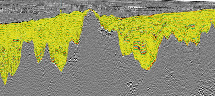
Previous issues: www.geoexpro.com
Contents
Vol. 17 No. 2
This edition of GEO ExPro focuses on North
GEOSCIENCE & TECHNOLOGY EXPLAINED
America and the Gulf of Mexico; New
Technologies; Near Surface Geophysics;
Doug Sprinkel, UGS.
and Changing Public Perceptions.
30
The 2004 discovery the Covenant 5 Editorial
field in Utah was expected
to be a play opener, so why 6 Regional Update: Dreary Investment
have subsequent results been
disappointing? Outlook
8 Licensing Update: Covid-19 Hits
Licensing Rounds
10 A Minute to Read
12 Cover Story: GEO Science Explained:
© Elnur/Dreamstime.com
48
Universities and graduate training Locating Sweet Spots: Shale
must respond and adapt to industry Petroleum Systems
needs to cope with the digital
transition. 16 Exploration: Mexico’s Energy Reform
20 Seismic Foldout: Exploring the Highly
Brian Williams
Prospective Orphan Basin
50
A look at the fascinating geology 26 GEO Physics: Marine Site Investigation
and stunning landscapes of the and Reducing Risk
Dingle Peninsula in south-west
Ireland. 30 Exploration: Central Utah Thrust Belt –
A Lost Cause?
34 Recent Advances in Technology: From
56 Arrhenius to CO2 Storage – Part VII
Combining geochemistry and
microbiology can effectively de-risk
APT 38 Technology: China’s Deep, Hot, Harsh
offshore deepwater oil and gas Reservoirs Spur Innovation
exploration.
42 Seismic Foldout: The ‘Searcher-Engine
for Oil’ in Mexico’s Hottest Hotspot
Michael Chidsey,
Sqwak Productions Inc.
48 GEO Education: Big Data and Post-
Graduate Training
60
50 GEO Tourism: A Kerry Diamond
Thomas Chidsey is a senior
scientist at the Utah Geological 54 Hot Spot: Pannonian Basin
Survey and likes nothing better
than telling people about the 56 GEO Chemistry: Geochemistry and
geology of his adopted state.
Microbiology in Seep Prospecting
60 GEO Profile: Thomas Chidsey – Going
the Extra Mile
50 11 70 64 Seismic Foldout: Morocco – Lixus
20
30 60 12 56 54 Offshore
64
38
6 10
16 42 70 70 Exploration Update
72 GEO Media: Travels to Rocky Places
74 Q&A: Girls into Geoscience
70
76 FlowBack: Time to Regroup
GEOExPro May 2020 3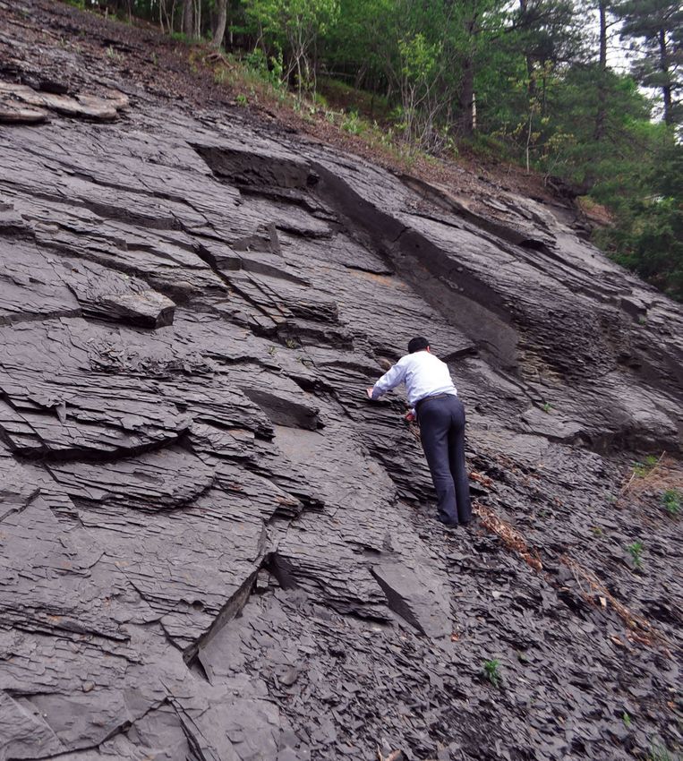
Editorial
The World in Freefall GEOSCIENCE & TECHNOLOGY EXPLAINED
All over the world, there is only one topic www.geoexpro.com
of conversation: Covid-19. The pandemic
has resulted in some welcome shows of GeoPublishing Ltd
solidarity, as countries help each other 15 Palace Place Mansion
out with medical assistance, urgent Kensington Court
London W8 5BB, UK
supplies and, importantly, research into
+44 20 7937 2224
vaccines and cures. It will undoubtedly
have some positive long-term effects on Managing Director
Gerd Altmann/
the environment, as people appreciate Tore Karlsson
the clear skies, low pollution and sounds
Pixabay
Editor in Chief
of birdsong resulting from fewer planes Jane Whaley
and cars. Working from home and video- jane.whaley@geoexpro.com
conferencing may well become the norm.
Like many industries, however, oil and gas has been severely hit by the fallout from the Editorial enquiries
GeoPublishing
pandemic, with both demand and the price of oil slumping at a time of already worldwide
Jane Whaley
surplus, exacerbated by additional pumping by Saudi Arabia and Russia as they follow their +44 7812 137161
own competitive agendas. A number of E&P companies are reported to be cutting their jane.whaley@geoexpro.com
CAPEX budgets for 2020 by around 20%, which will see many planned exploration projects, www.geoexpro.com
particularly in capital intensive areas like deepwater, mothballed for the foreseeable future. As
Sales and Marketing Director
a debt-heavy industry, the security for which is usually oil and gas reserves – now worth a lot Kirsti Karlsson
less than they were just a few months ago – we can expect to see bankruptcies, in the service +44 79 0991 5513
sector as well as E&P companies of all sizes. These will result in further job losses, in an kirsti.karlsson@geoexpro.com
industry that was only just beginning to climb out of the last slump. It is a miserable scenario.
Oil will recover, but it will take time. Because of the glut in supply, an increase in demand will
not immediately result in rising prices – although the cheaper energy resulting from this lag in
oil price increase could help world economies recover faster once the virus restrictions are lifted.
Subscription
You will be pleased to hear that GEO ExPro will continue to publish both online and in
GeoPublishing Ltd
hard copy, bringing you the information on exploration and technology in the upstream +44 20 7937 2224
geosciences you need in order to be ready to bounce back when the 15 Palace Place Mansion
crisis is over. The print magazine will be distributed to companies and Kensington Court
London W8 5BB, UK
subscribers worldwide as usual; many conferences and meetings have
kirsti.karlsson@geoexpro.com
been postponed until later in the year, so we will also reserve copies of
each edition to be distributed at those, whenever they may be held. GEO EXPro is published bimonthly
I would like to take this opportunity to send best wishes from the for a base subscription rate of GBP
whole GEO ExPro team to anyone affected by the virus, either in health 60 a year (6 issues).
We encourage readers to alert us
or in business, and look I forward with you to better times ahead. to news for possible publication
Jane Whaley and to submit articles for publication.
Editor in Chief
Cover Photograph:
Main Image: Rasoul Sorkhabi
Inset: Richard Hamilton, SAND
Geophysics
LOCATING SWEET SPOTS: SHALE PETROLEUM SYSTEMS Layout: Mach 3 Solutions Ltd
Print: Stephens & George, UK
Our cover shows long-term GEO ExPro contributor Rasoul Sorkhabi
inspecting the Marcellus Shale. For decades, shales were only viewed issn 1744-8743
as sources or seals, never studied for their reservoir properties. Can
conventional petroleum systems methodology help unlock the secrets of
these enigmatic rocks?
Inset: Using a 3D Chirp sub-bottom profiler during a marine site
investigation survey off western Canada.
© 2020 GeoPublishing Limited.
Copyright or similar rights in all material in this publication, including graphics and other media, is owned by GeoPublishing Limited, unless otherwise stated.
You are allowed to print extracts for your personal use only. No part of this publication may be reproduced, stored in a retrieval system, or transmitted in any
form or by any means electronic, mechanical, photographic, recorded or otherwise without the prior written permission of GeoPublishing Limited. Requests
to republish material from this publication for distribution should be sent to the Editor in Chief. GeoPublishing Limited does not guarantee the accuracy of the
information contained in this publication nor does it accept responsibility for errors or omissions or their consequences. Opinions expressed by contributors to
this publication are not necessarily those of GeoPublishing Limited.
GEO ExPro May 2020 5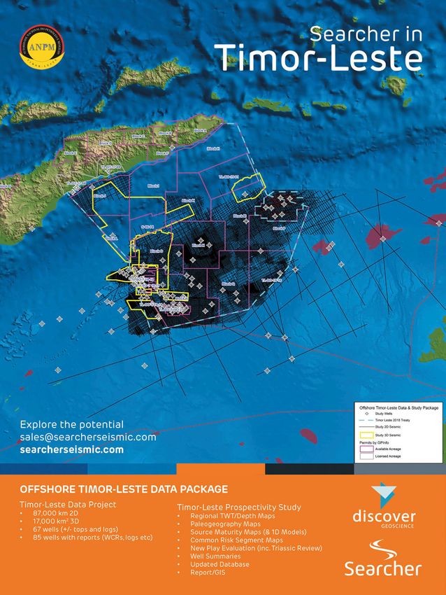
Regional Update

A Dreary Investment Outlook?                                                               ABBREVIATIONS

Gulf of Mexico final investment decisions are likely to be put on hold.
                                                                                           Numbers
Exploration and production companies in the Gulf of Mexico have now joined                 (US and scientific community)
the budget-cutting parade, slashing capex in order to stay afloat in this new oil          M: thousand         = 1 x 10³
market reality. Players such as Talos Energy, Murphy and Kosmos have put new               MM: million         = 1 x 10⁶
                                                                                           B: billion          = 1 x 10⁹
sanctioning on pause, with the exception of approved projects, and additional cuts
                                                                                           T: trillion         = 1 x 10¹²
are being evaluated. Indeed, signs have already emerged indicating that the dual
supply and demand shock will have a deeper impact on E&P sanctioning in the
region than seen during the previous oil price crash in 2016. Reduced exploration          Liquids
activity and postponed new development sanctioning will be key to improving the            barrel = bbl = 159 litre
current cash flow situation.                                                               boe:      barrels of oil equivalent
   Investments furthest removed from revenue generation will be the first to go as         bopd:     barrels (bbls) of oil per day
part of E&P cost-cutting efforts. In that sense, exploration activity will take a hit in   bcpd:     bbls of condensate per day
2020 as operators postpone the spud timing of exploration wells in order to push           bwpd: bbls of water per day
exploration expenditure further into the future. Over the last five-year period,
infrastructure lead exploration (ILX) has been a favored exploration strategy              Gas
in the Gulf of Mexico due to higher success rates, lower required development              MMscfg: million ft3 gas
investment and quicker payback time. However, the current situation is of such             MMscmg: million m3 gas
magnitude that we believe even ILX will take a hit.                                        Tcfg:   trillion cubic feet of gas

                                                                                           Ma:         Million years ago

                                                                                           LNG
                                                                                           Liquified Natural Gas (LNG) is natural
                                                                                           gas (primarily methane) cooled to a
                                                                                           temperature of approximately -260 oC.
Source: Rystad Energy’s UCube

                                                                                           NGL
                                                                                           Natural gas liquids (NGL) include
                                                                                           propane, butane, pentane, hexane
                                                                                           and heptane, but not methane and
                                                                                           ethane.

    Capital and exploration expenditures in the US Gulf of Mexico.                         Reserves and resources
                                                                                           P1 reserves:
Looking Ahead                                                                              Quantity of hydrocarbons believed
In the mid-term, cost-cutting measures will affect the development side of the             recoverable with a 90% probability
investment cycle as well. The rapid oil price decline has left investment decisions
more or less on hold. E&P companies are closely monitoring the situation, awaiting
greater clarity in the oil price outlook before committing cash to currently               P2 reserves:
unsanctioned projects. One example of this is the North Platte development,                Quantity of hydrocarbons believed
where platform construction bids have been put on hold by Total. However, as               recoverable with a 50% probability
time marches onwards and E&Ps become accustomed to a lower oil price outlook,
we expect some sanctioning will occur in the latter part of 2020; subsea tieback
                                                                                           P3 reserves:
developments can have breakeven prices that offer positive net present value in a
                                                                                           Quantity of hydrocarbons believed
$30 oil price environment.
                                                                                           recoverable with a 10% probability
   Capital and exploration expenditures will get a trim, but we see that the efforts
will be made on discretional expenditures, which can be deferred. Sanctioned
projects are expected to proceed, although some delays might occur in order to             Oilfield glossary:
temporarily reduce expenditures. Current investments directed at the Gulf of               www.glossary.oilfield.slb.com
Mexico are primarily related to existing projects under execution, and we see that
the ongoing lack of investment decisions – in addition to a lower oil price outlook
– could cause a dreary investment outlook in the coming years.
                                             Joachim Milling Gregersen, Rystad Energy
6 GEOExPro                      May 2020
GEOExPro May 2020 7
Licensing Update
Covid-19 Hits
Licensing Rounds
Quaternary
Neogene
2.6
Tertiary
Cenozoic
South Atlantic starts opening
23
Paleogene
As Covid-19 spreads its infectious tentacles ever further and tighter
around the globe, it is no surprise to see the knock-on effect of the
pandemic on licensing round plans throughout the world. Here is a
66*
Norwegian-Greenland Sea starts opening
brief summary of some announcements to date.
Alpine orogeny
Cretaceous
Laramide orogeny
Bangladesh: The Ministry of Power, Energy and Mineral Resources
had planned to announce in March that the launch of Bangladesh’s
next offshore licensing round – the first for eight years – would
open on 15 September 2020, with a deadline for bid submissions
Pangaea breakup
on 10 March 2021 and the award of production sharing contracts 145
Mesozoic
by 26 May 2021. This has now been postponed indefinitely. The Jurassic
round would have concentrated on deepwater blocks thought to be
North Sea rifting
prospective for gas, close to the maritime border with Myanmar.
After the last offshore round, several blocks were awarded, but no
Central Atlantic starts opening
wells have yet been drilled. 201*
*The Big Five Extinction Events
Lebanon: As reported in GEO ExPro Vol. 16, No. 1 (2019), the Triassic
deadline for submission of applications for the 2nd Lebanese
Offshore Licensing Round was initially set for 31 January 2020. In 252*
January this deadline was postponed to 30 April 2020, and it has
Gulf of Mexico rifting
Permian
now been pushed that back to 1 June 2020. Award decisions are
Phanerozoic
expected to be made about September 2020. The round encompasses
Blocks 1 and 2 in the northern part of the Lebanese offshore, and 299
Blocks 5, 8 and 10 in the south, close to the Israeli border. Carboniferous
FORMATION OF PANGAEA
Liberia: The Liberia Petroleum Regulatory Authority opened its
2020 round qualifications on 15 April 2020 as planned, but to
prevent the spread of Covid-19 the launch event was conducted via
a webinar, attended only by Liberian delegates. The round covers 359*
nine blocks in the Harper Basin, one of the last unexplored and Paleozoic Devonian
undrilled regions offshore West Africa.
India: India’s Directorate General of Hydrocarbons has announced
that, in view of the lockdown due to the Covid-19 pandemic, the
Variscan orogeny
last date for bid submissions in the Open Acreage Licensing Policy 419
Silurian
Bid Round V will be extended, although no revised date has yet
been notified. This round covers 11 blocks, eight of which are 443*
Ordovician
Caledonia orogeny
onshore and three offshore. In addition, the ‘Expression of Interest’
(EOI) cycles for Round VI, due to have ended March 31 and Round
VII, scheduled to end July 31, 2020, will be merged, with bidding
based on EOIs received by the end of July. 486
South Sudan: The world’s youngest country had planned to launch Cambrian
its first license round in Q1 2020, with 14 blocks in the north of
the country on offer. However, with uncertainty around the state
of the industry post coronavirus, the launch has been deferred The Great Unconformity 541
indefinitely. South Sudan produces 178,000 bpd but hopes to reach
250,000 bpd soon.
Neoproterozoic
Precambrian
United Kingdom: The UK’s Oil and Gas Authority has confirmed
there will be no new offshore licensing round in 2020. It hopes that
this will allow more relinquishments to take place so more areas will
be available when a round is announced at an as yet unplanned date.
8 GEOExPro May 2020
GEOExPro May 2020 9

A Minute to Read… News from around the world
URTeC 2020: Now More Than Ever
Get the training your team needs to maximize efficiency
AAPG
and profitability. Business and social connectivity is
particularly important during challenging times. That’s why
the Unconventional Resources Technology Conference
(URTeC), July 20–22 in Austin, Texas, remains critical to
you, your colleagues and your business.
URTeC will deliver value by leveraging expertise from
all technical backgrounds – geochemistry, rock mechanics,
seismic technology, horizontal drilling, completion methods,
cost control, and project management – and by examining
what is working within the current business environment. It
is the best opportunity you will have to exchange information,
formulate strategic ideas and solve problems to manage and
optimize your unconventional resource plays.
The objectives of the conference are to provide a high quality and peer reviewed science and technology experience; to
create a premier forum for technical exchange between vendors and users; to identify and solve E&P problems; and to raise the
competency of all petroleum professionals.
In good and in difficult times, bringing together professionals from across disciplines is the best way to find solutions. Plan
now to attend URTeC to connect with everyone and everything unconventional.
Shearwater Enters Deepwater OBS Market
Provider of marine geophysical services Shearwater GeoServices has been awarded a major ocean bottom seismic (OBS)
deepwater remotely operated survey (ROV) project by TGS and partner in the US Gulf of Mexico.
The company already has an extensive track record of innovation and commercial success in OBS, but this is the
company’s fi rst OBS ROV survey, making Shearwater the only company offering a complete portfolio covering towed
streamer and OBS marine acquisition, along with associated
processing services. The addition of deepwater OBS ROV operations
to its ocean bottom node capabilities will leverage the company’s
strengths in source capabilities, operational scale and flexibility and
marks its presence in all sectors of the OBS market, in both acquisition
and processing.
The survey will start in Q2 2020 and is expected to take about four
months. It will use the SW Diamond and SW Emerald, which are
equipped with three high-capacity sources each composed of three sub-
arrays, allowing the data to be acquired using two source vessels instead
of three for the survey, with a consequent increase in efficiency and
reduction in operational greenhouse gas emissions.
Waste to Tackle Waste
Researchers at Flinders University in Australia have come up with a novel
way to clean up oil spills, using waste cooking oil from fast food outlets and
sulfur, a by-product of the petroleum industry. The resulting product (right) is
a hydrophobic polymer – meaning that it separates from water and binds well
to oil, which it absorbs much like a sponge, forming a gel that can be scooped
out of the water. It is capable of absorbing 2–3 times its mass in oil or diesel
and is reusable, as recovered oil can be squeezed from the polymer like water
from a sponge; the oil can also be reused.
Flinders University have now entered into a deal with Clean Earth
Technologies, a company that specializes in developing cleaner approaches
Flinders University
and outcomes for tapping the earth’s richness, in order to commercialize the
Justin Chalker,
absorbent polysulfide, which can also be used as a clean-up solution to other
environmental problems like mercury pollution and fertilizer runoff.
Using waste to tackle waste; a truly ‘green’ solution.
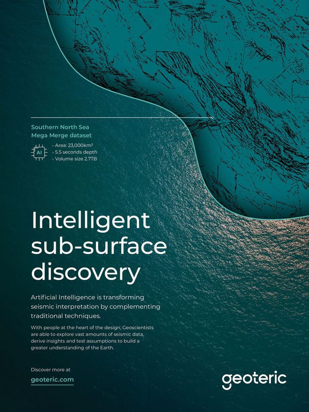
10 GEOExPro May 2020Structural Reconnaissance with Artificial Intelligence
Artificial Intelligence (AI) algorithms can significantly
Geoteric
speed up the interpretation of large datasets. Fault
delineation is one of those areas where AI can deliver an
independent, unbiased input for the structural interpreters.
A basin scale structural reconnaissance provides an
efficient overview of the main structural elements and
trends, while a regional resolution structural framework
assists in understanding the development of a trap. A more
detailed analysis can focus on the reservoir to understand its
compartmentalization. And finally, at well resolution the AI
algorithms can highlight fault-related risks and offer valuable
insight for the post-drill well performance analysis.
In the example on the right, the Southern North Sea
Megasurvey, provided by the UK Oil and Gas Authority,
was analyzed with the Foundation Network developed by
Geoteric (see GEO ExPro, Vol. 16, No. 2, 2019). Although there are blank zones in the dataset, the actual seismic data covers
around 24,000 km2, offering an unparalleled insight into the complex tectonics of the North Sea. The high quality results offer
an excellent starting point for further, more focused studies, revealing intricate details of a complicated tectonic history.
AAPG Annual Conference Update
Geoscientists and industry professional alike have asked about topics and content will provide a more engaging and dynamic
the current status of the American Association of Petroleum geoscience exchange. The event will also include 15 forums
Geologists (AAPG) Annual Convention and Exhibition and special sessions, 11 short courses, eight field trips, nine
(ACE), June 7–10, 2020. Based on ongoing evaluations, close networking events, four luncheons, U-Pitch presentations,
coordination with the City of Houston, and our understanding student and young professional activities, and more.
of current advisories, the event is still scheduled as planned, Attend with complete confidence as our registration
but we are carefully monitoring the situation. cancelation policies have been updated. Cancelations will
As the global community confronts these challenging times, now be accepted with a full refund if received before May 1,
the health and safety of our members, customers and employees 2020 and any cancelations received between May 1–31 will be
remains our primary concern. With many of the current assessed a $75 processing fee and the balance will be refunded.
declarations and advisories in effect through April, we will Unless ACE is postponed or canceled, refunds will not be
provide additional updates on May 1 or sooner as warranted. processed after May 31, 2020. Due to instructor and direct
The program features more than 1,000 diverse and expense obligations, the refund deadline for Short Courses
informative technical talks and posters spanning 15 and Field Trips will continue to be April 23. No refunds for
concurrent sessions. Newly integrated presentation formats, field trips and/or short courses can be made after this date.
Searcher Opens UK Office
Ground-breaking privately owned seismic company Searcher Searcher
has opened a UK office in Woking, near London, as a platform
to manage its future global new business activities. This is a
perfect location to manage the creation of new seismic datasets
in Latin America, Africa, Europe, Middle East and the Far East,
building on the extensive multi-client datasets Searcher already
holds. “We are so thrilled to be launching this new platform
into a market excited for innovative 3D and 2D seismic
datasets,” said Debbie Sewell, Searcher’s new VP Global
Business Development. “With our sister companies ‘Finder’
and ‘Discover’, this will help us to bring additional value and
business solutions.”
One of Debbie’s first tasks for Searcher was at the 2020
APPEX event in early March, where she awarded Kevin Dale,
Geoscience Advisor at Sasol, with the booth draw prize; 40
trees planted for carbon offsetting. She explained that carbon offsetting is a major part of the Searcher creativity message and
that she believes that attention to detail is what makes the company special.
GEOExPro May 2020 11Cover Story: GEO Science Explained
Locating Sweet Spots:
Rasoul Sorkhabi
Shale Petroleum Systems
Petroleum system analysis has been a major tool in petroleum
geoscience and exploration – but can it help locate shale ‘sweet
spots’ and thus increase production, reduce risk and minimize
the environmental footprint? RASOUL SORKHABI, Ph.D.
In the last decade US oil production increased by 60%, to Petroleum System Analysis
over 13.4 MMbopd by early 2020. This increased production, When the oil industry began in the 1860s, all oilmen
which has been partly responsible for depressing oil prices, wanted to fi nd were seeps and anticlines to drill. In the
has been made possible essentially because of the shale 1920s, they began to develop concepts and technologies to
revolution, since US conventional crude production has been quantitatively study reservoir rocks. For the next 50 years,
in decline for decades. subsurface mapping and characterization of reservoirs
The shale revolution in the US is currently limited to a few and traps by geological and geophysical methods was the
basins and formations: the Permian, Barnett and Eagle Ford focus in exploration. It was not until the 1970s that source
in Texas, the Bakken in North Dakota, and the Marcellus in rock studies drew serious attention from the industry and
the Appalachian east. However, there are numerous other geochemists developed techniques to identify kerogen
shale plays in North America and elsewhere in the world, and types and estimate thermal maturity of source rocks,
many other countries regard their shale resources producible based mainly on vitrinite reflectance microscopy. As
if economic and technological conditions became optimal. computational and digitization techniques were developed
Meanwhile, there are some fundamental questions about shale in the 1980s, it became possible to perform basin-scale
science that we do not understand. Given that shale formations modeling of oil generation, migration, and accumulation, as
are self-sourced and self-sealed reservoirs, how can we apply geochemists developed ideas and methods to characterize
petroleum system analysis, a methodology developed for petroleum source rocks.
conventional reservoirs and prospects, to these formations? Can A petroleum system consists of physical elements and
petroleum system analysis reduce risk and increase productivity associated processes and here we briefly describe them for
of shale petroleum? This article aims to address these questions. shale formations.
A view of fractured Marcellus Shale of Devonian age in West Virginia (the author is in the picture for scale).
Rasoul Sorkhabi
12 GEOExPro May 2020as Hydrogen Index or S2/TOC from pyrolysis); otherwise,
pure organic carbon would produce graphite.
Moreover, the rock should be sufficiently buried and
heated to generate hydrocarbons. There are several methods
to estimate the paleo-temperatures of source rocks,
including burial history diagrams, Tmax readings from S2
peak in pyrolysis experiments, and vitrinite reflectance (R0)
measurements. Hydrocarbons are generated in a temperature-
dependent, step-wise sequence of kerogen (insoluble in
ordinary organic solvents) to bitumen (soluble in organic
solvents) to heavy crude, light crude, wet gas, and dry gas. In
this fractionation, hydrocarbons become simpler and lighter
molecules.
Rasoul Sorkhabi
Many Faces of Migration
Once oil and gas have been generated in the source rock,
Petroleum system analysis in shale formations. some will be expelled and will enter the basin, but some will
remain within the formation. Hydrocarbon expulsion from
Source Rock and Generation the source rock is called primary migration. The expelled oil
Petroleum source rock contains kerogen – highly complex and gas, being buoyant, will then flow (secondary migration)
organic compounds that thermally crack to hydrocarbon through porous carrier beds or open fractures and will
molecules as the rock is progressively buried and heated by eventually accumulate in enclosed reservoirs (pools). Most of
overlying sediments. The source rock is the petroleum basin’s the expelled hydrocarbons, however, diffuse in the basin.
‘kitchen.’ Black claystone (mudstone, shale and marl) is the The ratio of how much oil or gas is expelled from the
best source rock because it retains plenty of kerogen within source rock and how much is retained in the rock formation
its pore space. Limestone can also be a good source rock. differs for various source rocks depending on their conditions.
Coal essentially generates natural gas, although deltaic coal Studies of Barnett Shale, for instance, suggest that 60% of
formations can produce some oil. generated oil was expelled and 40% was retained in the
Not all clay-rich rocks generate hydrocarbons; it depends shale. However, some researchers do not consider expulsion
on the amount of organic carbon in the rock, which is mechanisms to be very effective, and believe that perhaps as
measured as percentage of total organic carbon (TOC). Less much as 80% of hydrocarbons are retained in the source rock,
than 0.5% suggests poor source rock, while TOC of 2–4% possibly because oil saturation in shale plays has been found
indicates very good source rocks. Aside from high TOC, the to be over 75% of the rock’s porosity. How much hydrocarbon
source rock should also possess organic hydrogen (measured is generated in shale and how much is expelled or retained
Hydrocarbon generation in shale. Note that aside from temperature, kerogen type also plays a role in the amount of oil or gas generation.
Rasoul Sorkhabi
GEOExPro May 2020 13Cover Story: GEO Science Explained
by permeability (milliDarcy for
Rasoul Sorkhabi
conventional reservoirs).
Shale formations are tight rocks
with clay-sized grains less than 4
μm diameter and small pore throats
0.1–0.005 μm. Shale formations
have porosities less than 10% and
rock permeabilities in nanoDarcies.
Because of these tight properties,
shale targets are stimulated by
hydraulic fracturing to produce oil
or gas.
Porosity structure in a shale
is divided into matrix (inorganic)
porosity, kerogen (organic) porosity,
and natural fracture porosity. Free
(mobile) oil resides in the matrix
and facture pores; adsorbed and
absorbed oil is in kerogen (organic)
porosity. Organic matter has 44
times more adsorptive power than
quartz; therefore, kerogen porosity
Lithological spectrum from sandstone to shale reservoirs and their petrophysical comparisons.
is important, although the quality
and producibility of sorbed oil in
remain interesting questions to be investigated using various shale should also be considered. Fracture porosity has not
cases and simulations. been observed to be a major storage feature. Shale porosity
The retained oil in shale can both stay in place and migrate can be calculated on samples in a laboratory or from wireline
within the formation. Intra-formational migration seems to log measurements such as bulk density, neutron porosity, and
be counter-intuitive because shale as a source rock is a very sonic logs, although these have traditionally been developed
tight (low permeability) oil-wet rock. But two important and calibrated for sandstone and carbonate reservoirs, so well
mechanisms can migrate oil or gas within the shale formation. log petrophysics for shale requires more work.
First, shale formations are not homogenous; they contain Fractures provide the main permeability in shale
relatively high-permeability layers (sand, silt or limestone) and formations. Natural fractures in shale may be divided into
fractures which can facilitate oil and gas migrating updip the four categories: bedding-parallel fractures (if mudstone
formation. Second, during the compositional fractionation has been deeply buried to develop fissile platy structures,
of hydrocarbons (from heavy oil to dry gas), the buoyancy of so typical of shale); bedding-vertical joints with spacing
lighter hydrocarbons (with high APIs, high solution gas-to- related to the layer thickness: fracture spacing increases
oil ratios and lower viscosity) will provide a migratory force. with thicker beds; tectonic fractures associated with
Compositional fractionation of hydrocarbons
also happens during production when the Kerogen types in shale and their pyrolysis characteristics. Hydrogen Index and S2/S3
produced hydrocarbons have different gas-to- are derived from pyrolysis of shale samples. S1 is the amount of free hydrocarbon in the
oil ratios than their initial values in the rock. sample; S2 is the amount of kerogen (in mg HC/g); S3 is the amount of carbon dioxide. The
unit for all these three peaks is mg HC/g. Hydrogen Index is S2/TOC (Peters and Cassa, 1994,
Intra-formational migration observed in the AAPG Memoir 60).
US Barnett, Niobrara and Bakken Formations
indicates that polar hydrocarbon compounds
(resins and asphaltenes) remain in situ
because of their high sorption (adsorption and
absorption) in kerogen porosity, while saturates
and aromatics move into organic-lean porous
intervals.
Reservoir Storage and Production
A petroleum reservoir has two functions:
firstly, it stores oil or gas; and secondly, it acts
as a conduit to yield oil or gas into production
wells. The storage capacity is measured by
porosity (the percentage of pore space in a
volume of rock); the yield capacity is measured
14 GEOExPro May 2020folding and faulting; and
micro-fractures arising from
hydrocarbon generation in the
rock (conversion of kerogen to
hydrocarbon involves volume
increase and fluid overpressure
in the rock). Natural fractures
in the rock may be open or
closed (healed by mineral veins
or compressional stress) but
only open fractures will be
conductive.
Sealing and Entrapment
In conventional (migrated
hydrocarbon) reservoirs, cap
(seal) rock is necessary to
prevent the upward migration
Hydrocarbon fluid types in reservoirs. API values are for stock-tank-oil gravity at surface conditions. The gas-
of oil or gas. The cap rock, to-oil ratio is in standard cubic feet per stock-tank oil barrel at standard conditions of 60°F and 14.7 psi.
usually mudrock or salt, is a
fine-grained, water-wet, low porosity and low permeability mg oil/g TOC), the shale has producible oil, although he also
formation. By contrast, except for the expulsion or tectonic notes that measurements of S1 peak (free hydrocarbon in
fracturing processes, shale formations are self-sealed pyrolysis) and TOC need to be reasonably accurate for this
reservoirs. exercise.
Traps are geometrical configurations that provide a
closure for the accumulated oil or gas in the reservoir. Back to the Future
Traps in conventional prospects are divided into structural, Shale gas production dates back to the 19th century and
stratigraphic, hydrodynamic and combination types. This hydraulic fracturing began in the 1940s. Nevertheless, at the
classification is not directly applicable to shales; however, turn of this century, no one would have predicted the coming
lithological variations (both lateral and vertical) related shale revolution. Shales were only viewed as sources or seals;
to depositional processes play an important role in the they were not cored, logged or studied for their reservoir
framework of shale formations. properties. Shale petroleum system analysis is, therefore, in
its infancy. Nevertheless, several important points require
Classification of Shale Reservoirs attention.
Compared to sandstone and carbonate reservoirs, our Firstly, total petroleum systems include both migrated
knowledge of shale as a petroleum reservoir remains poor. In and self-sourced reservoirs; this is a major addition to the
recent years, some researchers have classified shale reservoirs global hydrocarbon budget. Secondly, like conventional ones,
in North America into three categories: tight shale, in which petroleum systems in shale are dynamic, in which all the
source and reservoir localities are the same; hybrid shale, elements and processes need to be evaluated and integrated
where shale is interbedded with more porous but organic- to locate sweet spots for drilling and production. Given the
lean siliceous or calcareous layers; and fractured shale, often heterogeneities and complexities of shale formations, it is
rich in heavy oil or dry gas, where natural fractures provide necessary to conduct petroleum system analyses in numerous
considerable permeability and porosity. Of course, these are locations of the same shale play. Thirdly, the shale revolution
end-member categories. It is inconceivable to have a shale has motivated us to investigate significant uncertainties in
formation which does not exhibit lithological heterogeneity or our measurements of TOC, pyrolysis (for example, correcting
has remained unfractured. for evaporative loss of hydrocarbons in S1 peak), porosity,
Some researchers divide shale reservoirs into argillaceous, permeability, and so forth. Shale production requires higher
calcareous and siliceous, based on the relative abundance resolution geoscience.
of clay, carbonate, and silica minerals in the rock. Ternary Finally, production from shale formations are drastically
diagrams using these mineralogical data indicate if the shale different from conventional reservoirs. Recovery in shale is
is more brittle (high silica) or not. These are informative less than 10% for oil and about 15–20% for gas, compared
exercises to understand the response of the shale formation to to about 50% oil recovery and up to 80% gas recovery in
hydraulic fracturing. conventional reservoirs. Shale wells have sharp decline rates
A third classification is to divide shale plays into ‘active’ and last only a couple of years, compared to decades-long
(still in the oil or gas window) or ‘inactive’ (overcooked or conventional wells. Moreover, shale production consumes
uplifted) systems. It is important to know if a shale formation a lot of water for fracking and is associated with induced
has producible oil or not before drilling. Daniel Jarvie has seismicity, fugitive methane and other environmental issues.
suggested that if S1/TOC ratio is greater than one (i.e. >100 All this calls for better science and technology.
GEOExPro May 2020 15Exploration
Mexico’s Energy Reform
Five years on, what has Mexico’s energy reform delivered
for the country’s exploration and production ambitions?
ARUNA MANNIE, Premier Oil
The Mexican Constitutional Energy Reform took place in
CNH 2019
2014 in response to decreasing production, low oil prices,
increasing foreign debt and competition from neighboring
countries. It was the first time since 1938 that the country had
opened its doors to foreign energy investment.
Over 100 Licenses Assigned
Though it got off to a disappointing start with only two
out of the fourteen blocks successfully awarded in the first
round, it wasn’t long before the license round bidding became
competitive. Since then more than US$1.6 billion has been
paid in signature bonuses. The consistency, transparency and
persistence of the Mexican regulatory bodies over the past
five years saw 111 licenses assigned and at least US$35 billion
of investment from more than 76 companies (Figure 1), with Figure 2: Investment in seismic acquisition and reprocessing activities (US$).
commitments to drill a total of 413 wells for hydrocarbon
exploration and extraction by 2023. to sensibly allocate capital spending and drill fewer dry
However, with the change in governmental regime in holes.
the latter part of 2018, the incoming administration has The country has benefitted from a requirement for
halted subsequent licensing rounds until the energy reform companies to commit to a minimum percentage of capital
delivers on its committed work programs and production investment on national content and various technology
starts. This hiatus has advantages, in that it allows the transfer initiatives, ranging from collaboration on projects
service and support industries to prepare for the rapid with universities to the introduction of software and
growth and expansion of activities that is expected to occur technology. The rapid pace of the license rounds saw more
in the next few years. More importantly, it will allow time than US$3 billion invested in 2D and 3D seismic evaluations
for exploration wells to be drilled and evaluated to de-risk (Figure 2) and the energy reforms have already delivered
plays in the basin and allow companies and the government considerable success with the billion-barrel Zama discovery,
as well as the Cholula and Saasken
Figure 1: Over the past five years 111 licenses have been assigned to foreign companies. discoveries (Figure 3). Within just three
years the Amoca-Mitzon-Tecoalli,
Modified from CNH 2019
Hokchi, Ichakil-Pokoch and Trion
discoveries have been appraised by
foreign oil companies, adding more than
two billion barrels of 2P reserves (Figure
1). Mitzon first oil was in July 2019,
producing 8,000 bopd, with Amoca and
Tecoalli expected to come onstream in
early 2021, producing a combined total
of 100,000 bopd. Hokchi and Ichakil
are projected to produce first oil by
2020. With PEMEX existing contracts,
planned field developments and the
extraction contracts assigned in the
energy reform, peak production in 2021
is expected to be around 1.8 MMbopd,
up from the current 1.6 MMbopd,
although less than the 600,000 bopd
expected by the government by 2025.
Further increases will be dependent on
16 GEOExPro May 2020exploration success from wells bid in license rounds following the imaging and mapping of salt-related traps. In the next few
the energy reform. years, as discoveries are made and the race to first oil continues,
there will be challenges in supply chain management and the
What Were the Challenges? construction of infrastructure whilst maintaining the national
There were definitely advantages for Premier Oil in being a first content requirement.
mover in terms of international companies, but entering any
new international basin poses its own technical Figure 3: Drilling results from exploration wells (March 2020).
and operational challenges and the Sureste
Basin was no different. There were a number
of geological and geophysical questions, many
common to entering any underexplored basin,
especially in a country which is opening its doors
to foreign energy investment for the first time in
76 years. Stringent regulatory compliance such as
financial corporate guarantees and justification
of technical capabilities as an operator were some
of the barriers faced within a time-constrained
environment of the license round. This was to
ensure companies had the financial and technical
capabilities to invest what they promised to
deliver without having to be rescued by farm-outs
or ending up with licenses sitting idle for years.
Sparse well data availability and
inconsistencies in generic well data resulted
in the need for significant investment of time
spent on conditioning wireline logs and QC
of reports. In many cases the seismic imaging
was moderate quality at best, which challenged
GEOExPro May 2020 17Exploration
Exploration Risks Identified of hydrocarbons, and wells which lack an AVO response
With nine main geological basins in Mexico, covering a diverse were dry. The deepwater Sureste Basin (also known as the
set of sedimentological and tectonic settings, comprising Campeche Basin), is a frontier experience testing unchartered
clastics, carbonates, extension, compression, strike-slip, salt territory, with the Norphlet and Wilcox plays (successful in
diapirism, shale diapirism and even a meteorite impact there the US Gulf of Mexico) targeted by wells in 2020, including
is nothing more a geologist could ask for! With natural oil Chibu-1, which is currently drilling (Figure 1). As further
seeps oozing at the seabed, one can easily be captivated by the exploration wells are drilled in the basin, many of which
untapped potential within this oil-mature province. target the clastic plays, the amplitude story will be unraveled
Mexico shares its early geological history with the US Gulf of and result in better drilling decisions.
Mexico. Rifting initiated in the Middle Jurassic, providing the
accommodation for deposition of the laterally extensive Louann What Does the Future Hold for Mexico?
and Campeche salt deposits and subsequent deposition of the With more than 77 committed exploration wells to be drilled
world class Type II marine carbonate Tithonian source rock. in the next five years there will definitely be no slowing down
The Chicxulub meteorite impact at the end of the Cretaceous is of activity in Mexico. There is also the added advantage of
responsible for the carbonate fields to the east of Mexico. The being protected by the Production Sharing Contracts in a
Paleogene Laramide and Neogene Middle Miocene Chiapaneco lower oil price environment. Plays will be de-risked and our
compressional events resulted in rapid clastic deposition which understanding of the petroleum systems of the Mexican sector
influences the present day structural styles, such as salt- of the Gulf of Mexico will evolve rapidly. Billion-barrel fields will
withdrawal mini-basins, salt diapirs and associated structures, be few and far between due to confined trapping geometries,
compressional folds and listric faults. and it is thought that many discoveries are likely to contain
In the early days of exploration, the focus was primarily on recoverable reserves in the 50–250 MMboe range, requiring
the Sureste Basin, also known as the Salina de Istmo, a proven cluster developments. This could potentially lead to another
prolific hydrocarbon province. It has produced in excess of 18 wave of divestments and acquisitions in the next 3–5 years.
Bboe to date, mainly from Cretaceous carbonate reservoirs, The energy reform can help reverse Mexico’s declining
and is known for the supergiant multi-billion barrel Cantarell production and contribute toward the government achieving
oilfield, one of the largest anywhere in the world. Prospective its goal of increasing production by 600,000 bopd by 2025.
resources are in the order of 13 Bbo and 6.5 Tcfg (CNH 2018). However, this will require greater collaboration between
With current production focused mainly on the carbonates, the international oil companies and the Mexican regulatory
the majority of the established clastic players entering the bodies in order to reduce the timeline from discovery to first
basin were drawn to the seismic ‘bright-spots’ in the supra-salt oil without compromising technical and HSES standards.
and salt flank plays with the poorly imaged sub-salt traps as Clarity from the Mexican government on the future for
a potential upside. Post-drill analysis of wells in the Miocene foreign investment in the country’s energy sector will be
and Pliocene plays in the Sureste Basin revealed reservoir advantageous. The future could be a period in Mexico’s history
presence and seal as the main risks with a smaller percentage of increasing production and development of the Mexican
due to migration. economy as a whole, placing its people and the country on a
With wells few and far between and limited access to global stage with other producing countries worldwide.
seismic angle stacks it
was difficult to properly Figure 4: Gulf of Mexico structural elements – all the challenges a geologist could ask for!
understand the amplitude
responses especially in
light of the fact that there
EarthMoves
are structural traps at
similar depths and age
without AVO responses.
Having an understanding
of the regional geology,
including features such as
tectonic history, petroleum
systems expulsion
and timing and gross
depositional environment
were important for
prospect risking. To date,
with ten other exploration
wells drilled in the Sureste,
we know that seismic
‘bright-spots’ are not
always a reliable indicator
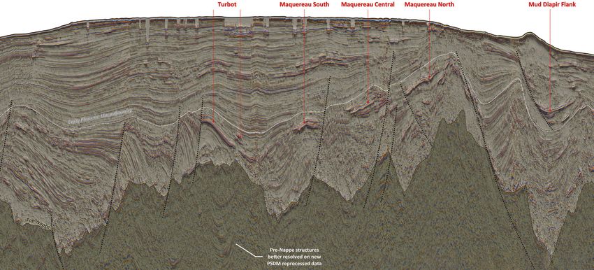
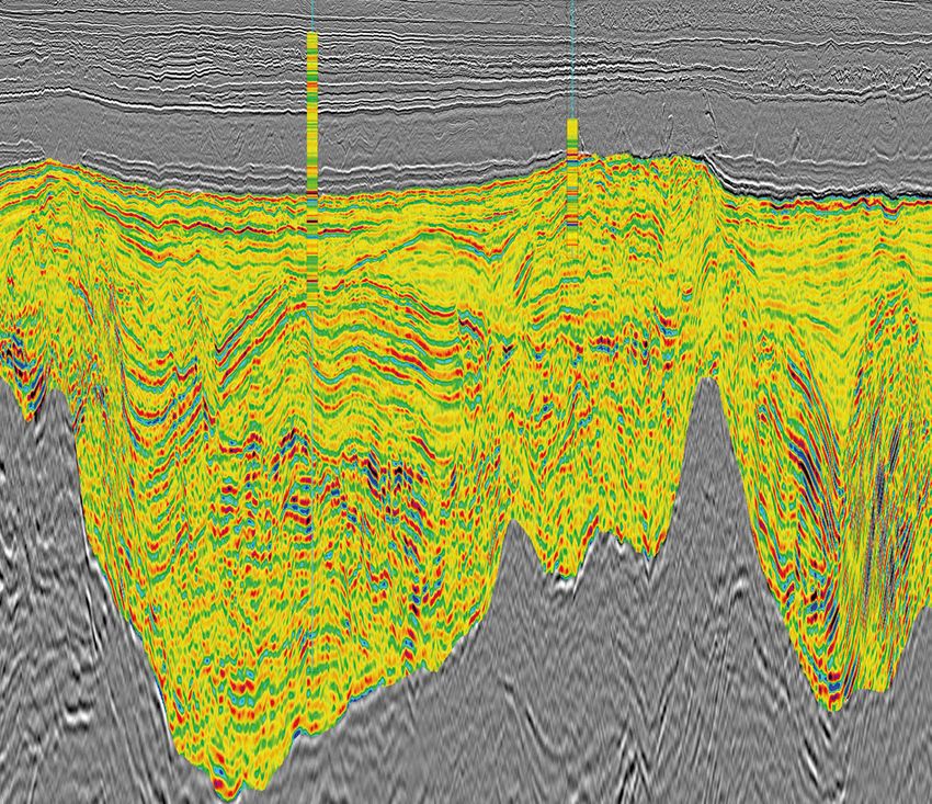
18 GEOExPro May 2020Orphan Basin, Canada:
A new, high quality regional dataset covering 22,469 km2 is
enabling the identification of important petroleum system
elements in the underexplored Orphan Basin, offshore eastern
Canada. Block evaluations for the upcoming license rounds
From Regional Prospect Screening
can be performed with confidence with this multi-sensor 205 km
broadband seismic data and its reliable pre-stack attributes.
The most recently acquired part of this regional dataset is the
to Reliable Reservoir Attributes North Tablelands survey, acquired in 2019 as an extension of the
Tablelands and Long Range surveys, which were shot in 2017–
Estimation
2018 by PGS and TGS. Figure 2: (a) Location of the Long
Range, Tablelands and North
Tablelands 3D surveys; (b) Locator
Fast-track data was delivered just five weeks after the last shot of map looking north across the
the North Tablelands survey. A full integrity volume is available surveys. The amplitude extraction
on the seafloor demonstrates
now and provides a single, continuous high-resolution seismic the modern day depositional
Figure 1: Regional line through the Long Range, Tablelands and North Tablelands surveys and key exploration wells showing the horst and graben dataset available for licensing early next year, encompassing the directions. The white line shows
structure of the Orphan Basin. Relative acoustic impedance is overlaid on the Top Cretaceous to Base Jurassic interval into the grabens resolving the track of the 2D seismic section
detailed structures and revealing additional opportunities characterized by low relative acoustic impedance (dark red).
Long Range, Tablelands and North Tablelands surveys. a below.
PGS
Margaree Lona Great Barasway
S b N
150 km
Top Cretaceous
Top Jurassic
Top Jurassic
Orphan High
Seismic Relative acoustic
amplitude impedance
+ +
East Orphan Basin East Orphan Basin
20 GEOExPro May 2020
20 km
-
GEOExPro May 2020 -
22Exploring the Highly
in the Tertiary section make identifying a) b)
PGS
stratigraphy and possible fluid effects easy. Work
over the three datasets using pre-stack relative
Prospective Orphan Basin
inversion has demonstrated fan geometries in
the younger section of the Orphan basin and the
northern portion of the Flemish Pass basin.
Advanced Tools Image Complex Geology
Eastern Canada is one of the most promising deepwater exploration areas in the world, where In addition to the regional imaging effort over
the implementation of state-of-the-art imaging technology is critical to develop a more this very large dataset, the implementation of
detailed local subsurface understanding. state-of-the-art imaging technology is critical
Figure 4: (a) 60 Hz one-way wave equation migration. (b) LSM delivers a higher
to develop a more detailed local subsurface
SCOTT OPDYKE, CYRILLE REISER, TIAGO ALCANTARA and ELENA POLYAEVA; PGS resolution image with significantly improved fault definition. Blue and orange markers
understanding. Full waveform inversion (FWI) indicate improvements in the Tertiary and Jurassic respectively. Blue arrows indicate
and least-squares migration (LSM) use the improvements in the Cretaceous and Jurassic.
First oil in the Jeanne d’Arc Basin was produced Open Acreage in Prospective Basins extra-broad frequency range recorded in the
in 1997 from the Hibernia Field and since then the Eastern Canada is one of the most promising deepwater GeoStreamer data to better estimate a detailed velocity Relative Vp/Vs overlaid on the pre-stack seismic (Figure
world-class oil-producing fields Terra Nova, White exploration areas in the world. In addition to the producing field and produce a robust image of the subsurface. In 5) around the Great Barasway well reveals some interesting
Rose and North Amethyst have come onstream, basins of East Canada, there are also some highly combination, they can minimize drilling risks and aid AVO anomalies characterized by very low relative Vp/Vs
while oil production from the Hebron Field started prospective underexplored basins such as the Orphan Basin reservoir understanding (Figure 3). values on the flank of the main structure. Based on the rock
in 2017. The Mesozoic basins of Grand Banks alone with potential for exciting new discoveries and world-class Depth migration techniques have been widely used in physics work, low relative Vp/Vs could indicate the presence
are estimated to hold recoverable reserves of 4.6 oil production. Access to new acreage, transparent fiscal areas with strong lateral velocity variation. Though very of hydrocarbons. These anomalies are of reasonable size, and
Bbo and 18.8 Tcf of natural gas. The 2009 Mizzen terms and a predictable land-sale policy make East Canada robust, traditional depth imaging methods suffer from can be spatially tracked on the 3D inset in Figure 5 bounded
oil discovery in the Flemish Pass Basin, estimated an attractive region for oil and gas exploration. acquisition and propagation effects that limit resolution and by some well-imaged faults.
at 200 MMbo recoverable reserves, proved the Exploration targets include Late Jurassic to Early impact the amplitudes in the resulting seismic images. LSM
extension of a working petroleum system, sourced Cretaceous fluvial to shallow marine sandstone is an emerging new imaging technique that compensates Rapid Prospectivity Evaluation
by the prolific late Jurassic source rock, into an area reservoirs sourced by prolific oil-prone Late Jurassic for acquisition limitations and variable illumination, and 3D GeoStreamer broadband seismic data acquired in the
where it was previously untested. This was followed marine shales. A mainly extensional margin provides provides more reliable amplitude information in particular last three years by PGS and TGS in the Orphan Basin
in 2013 by Harpoon and Bay du Nord fields. large structural traps and thick regional seals. Potential in areas of high structural complexity. In Tablelands, a data- demonstrates how regional prospectivity scanning can be
The Bay de Verde appraisal of Bay du Nord was reservoirs from Lower Cretaceous to Lower Tertiary are domain LSM approach was selected to improve the vertical combined with a detailed local appraisal of hydrocarbon
successful in 2015 as was the Baccalieu discovery in stratigraphically positioned above the Kimmeridgian seismic image resolution and enhance the fault definition potential using the high quality pre-stack data and rock
the same area in 2016. source rock super highway. especially in the syn-rift section (Figure 4). physics analysis. The use of state-of-the-art depth imaging
PGS, in partnership with TGS, have been GeoStreamer broadband data reveals a well-defined technologies leads to better subsurface images and improved
acquiring 2D and 3D GeoStreamer MultiClient rift section and high fidelity pre-stack seismic attributes Rapid Prospectivity Screening reservoir understanding. For the most recent North
data in Newfoundland and Labrador To facilitate a more rapid assessment of subsurface Tablelands survey high quality fast-track QI products were
Figure 3: FWI velocity model and LSM depth slice showing the structural
since 2011. The extensive library offshore prospectivity potential, a fast-track image was delivered produced to aid more rapid prospectivity evaluation for
conformability of the estimated high-resolution seismic velocity field.
eastern Canada and the seismic-based for North Tablelands together with QI products for ongoing and upcoming license rounds.
geological products for Newfoundland interpretation and integration with pre-stack broadband
and Labrador are comprehensive. Now attributes. Turnaround time was significantly
this library also includes the contiguous reduced by integrating the imaging and QI work Figure 5: Relative Vp/Vs extraction along a random line going through the Great
Long Range, Tablelands and North efforts. Pre-stack AVO QC was performed during Barasway F-66 well. Note the features of interest off-structure that could be
Tablelands surveys in the Orphan Basin the processing to ensure that the final pre-stack prospective both on the line of section above and the 3D visualization in the inset.
(Figure 2). The seismic data shown in data was fit for purpose and AVO/AVA compliant
PGS
the foldout (Figure 1) from Long Range for further QI analysis.
in the south to North Tablelands in the A final QI analysis including lithology and fluid
north demonstrates the numerous horsts prediction through a three-term AVO inversion
and grabens present in this part of the was performed on the full integrity data from
Orphan Basin. The existing fields and the Tablelands survey using all the available
discoveries are often drilled into rotated information including well log data. Three wells
PGS
fault blocks in the older section and are are present in the region of Long Range, Tablelands
adjacent to tilted half grabens and this and North Tablelands: the Great Barasway F-66
line indicates multiple opportunities well (drilled in 2006), Lona O-55 (drilled in 2010)
for prospective traps for the industry to and the Margaree A-49 well (drilled in 2013). These
test. The 3D data delineates play fairways three wells drilled the main reservoir and source
from the Orphan Basin in the north rock in the area. The Tithonian to Kimmeridgian
to the Jeanne d’Arc Basin in the south interval was used to build a regional rock physics
while the 2D data is available for regional model. The Great Barasway well was modeled and
interpretation and basin analysis. has a good tie to the source rock and high quality
siliciclastic reservoirs.
GEOExPro May 2020 23 24 GEOExPro May 2020GEOExPro May 2020 25
GEO Physics

Marine Site Investigation                                                                                          The evolving role of
                                                                                                                   seismic reflection

and Reducing Risk
                                                                                                                   data within offshore
                                                                                                                   site investigation.

MARK E. VARDY, SAND Geophysics

Marine site investigation is, at heart,               the ability to image the seafloor and                or risk mitigation phases is somewhat
about reducing risk. Sometimes                        subsurface structure continuously                    limited. For hazards, such as UXO or
it involves minimizing the risk to                    in 2D or 3D over large areas and at a                shallow gas, this often takes the form of
operations posed by UneXploded                        high fidelity. By combining multiple                 a presence/absence map, with limited
Ordnance (UXO), shallow gas, and/or                   different seismic methods, it is possible            information regarding the dimensions
unexpected ground conditions. Other                   to blend data with different resolutions             of the potential UXO or the gas
times, it mitigates the design risk for               and penetrations, providing both                     saturation within a possible gas front.
subsequent infrastructure, such as wind               sub-meter-resolution imaging of the                  When predicting ground conditions,
farm monopiles, by providing enough                   shallow subsurface and lower-resolution              the output from the seismic reflection
relevant information about the nature                 penetration of the full top-hole section,            interpretation commonly takes the form
of the subsurface to ensure the design                as required.                                         of a simplified ground model, mapping
is appropriate for the entire installation                                                                 the depths of key interfaces, facies
lifecycle. Alternatively, it can simply               Are We Maximizing Data Potential?                    thickness variations and key structural
involve reducing financial risk, such as              As is the case within all industries,                features such as faults.
ensuring the aggregates being targeted                however, one must always be asking the                  In reality, the seismic reflection
for extraction are a profitable resource.             question: are we getting maximum value               data contains much more detailed
    At the core of these investigations               from the techniques being employed?                  information about the nature of
sits seismic reflection data, a key                      This question has been posed                      the subsurface. Variability in the
methodology that is utilized across                   many times in recent decades with                    amplitude, phase, and architecture
all manner of site investigation                      regard to the seismic reflection data                of the reflections provide extremely
projects worldwide. Relatively cheap                  acquired as part of site investigations,             useful first-order information on the
and fast to acquire when compared                     primarily because the output from the                nature of the sediments comprising
to intrusive sampling techniques,                     geophysical part of a site investigation             the subsurface, under what conditions
seismic reflection surveying offers                   that feeds into subsequent design and/               they were deposited, and how they may
                                                                                                           have been deformed post-deposition.
A boomer seismic reflection section from a wind farm site survey. The seismic profile is overlain with
                                                                                                           Changes in bedding and post-
an example interpretation of major facies boundaries, along with a ground model constructed using
these. To illustrate how little of the complex, subtle detail on the original seismic reflection profile   depositional deformation are captured
is communicated in this ground model, a synthetic seismic section generated using only the major           both across major facies boundaries
facies boundaries is also shown (right). It is clear that, unless engineers and project managers look      as well as the, potentially more subtle,
at the seismic data, a huge amount of potentially useful information may not be communicated into
                                                                                                           internal patterns within each facies.
the later phases of a project. Data courtesy Crown Estates.
                                                                                                              The latter information can be
                                                                                                           particularly pertinent as it provides
SAND Geophysics

                                                                                                           a direct indication as to how the
                                                                                                           properties of a particular facies might
                                                                                                           vary across a site. Within the aggregates
                                                                                                           and offshore mining industries,
                                                                                                           such information can be critical in
                                                                                                           assessing the financial viability of a
                                                                                                           deposit, characterizing it as a 3D (or
                                                                                                           pseudo-3D) rock volume. For offshore
                                                                                                           construction projects, the variability
                                                                                                           of ground conditions within each
                                                                                                           facies is important for both health
                                                                                                           and safety decision-making, such as
                                                                                                           understanding the differential loading
                                                                                                           profi le between jack-up rig locations,
                                                                                                           as well as the engineering design. For
                                                                                                           cable and pipeline installation projects,
                                                                                                           understanding spatial variability in

26 GEOExPro        May 2020
You can also read