Major Regional Geophysical Surveys in NSW Position Talisman for Breakthrough Year in 2022
←
→
Page content transcription
If your browser does not render page correctly, please read the page content below
17 January 2022
    Major Regional Geophysical Surveys in NSW Position
         Talisman for Breakthrough Year in 2022
    Two large-scale geophysical surveys over gold and base metal projects to fast-track
    target definition process; Drill testing of priority targets to commence late January

                                            Highlights:
•     Two large-scale geophysical surveys, a regional Falcon® Airborne Gravity Gradiometry survey
      and a targeted VTEM™ Max Airborne Electromagnetic Survey, scheduled to commence in late
      January over Talisman’s extensive exploration portfolio in the Lachlan Fold Belt, NSW.
•     These geophysical surveys will provide a significant step-change to Talisman’s exploration
      efforts at the Lachlan Copper-Gold Project, delivering comprehensive datasets capable of fast-
      tracking the direct detection of geophysical anomalies related to potential new discoveries.
•     In parallel with the commencement of the geophysical surveys, drilling is also planned to begin
      shortly on four high-priority gold and base metal targets at the Lachlan Project.
•     The four drill programs will initially comprise up to 43 holes for 7,000m, targeting geophysical
      and geochemical anomalies in highly prospective areas with known mineralisation.
•     A new Exploration Licence Application has been submitted over recently vacant ground in the
      Parkes area, which is prospective for porphyry/epithermal copper-gold and orogenic gold
      deposits.
•     Talisman has completed the recruitment of a NSW-based exploration team to spearhead
      exploration efforts while minimising COVID-19 related travel disruptions.

Talisman Mining Ltd (ASX: TLM, Talisman) is pleased to advise that it has embarked on a multi-
pronged and potentially transformational exploration program for 2022 at its Lachlan Copper-Gold
Project (Lachlan Project) in NSW (Appendix 1).

Two large-scale regional geophysical surveys and a Reverse Circulation (RC) drilling program are
scheduled to commence in late January. The regional airborne geophysical surveys will fast-track
target generation and geological interpretation of Talisman’s portfolio, as well as providing direct
detection of geophysical anomalies related to mineralised systems.

The 7,000m/43-hole drilling program commencing in late January will test the following highly
prospective target areas:
   • Kaolin Shaft gold prospect;
   • Carpina North gold prospect;
   • Babinda copper prospect; and
   • Murray’s Mine gold prospect.

                                                                                                         1
Management Comment
Talisman’s CEO, Shaun Vokes, said: “The new year marks the start of an exciting and busy period
for Talisman in NSW. The scale of the two geophysical surveys that we are undertaking will provide
invaluable data on our tenement portfolio and allow us to potentially accelerate our mineral discovery
timeline. The surveys, which are typically only undertaken on this scale by much larger companies,
will allow us to readily focus our exploration activities on the most prospective areas. We are in a
unique position for a junior explorer in that revenue from our Wonmunna iron ore royalty allows us
to undertake such significant grass roots exploration work.
“Meanwhile, the re-commencement of drilling at the four gold and base metals targets will provide
regular news-flow and subsequent analysis of the geophysics will provide us with additional drill
targets. We now have a strong exploration team in place on the Eastern Seaboard with excellent
exploration credentials and experience, plus the balance sheet to undertake an extensive program
of activities in NSW in 2022. I am looking forward to some strong results in 2022.”
Regional Geophysical Surveys

Talisman has recently finalised an extensive review of the prospectivity vectors associated with
discoveries and known deposits in the Cobar Superbasin region of NSW. The review indicated that
all known mineral deposits have a significant gravity anomaly associated with economic
mineralisation and surrounding alteration halos.
The emplacement of sulphide mineralisation and associated higher-density silica alteration into
relatively lower-density sedimentary packages making up the basement rocks through the Cobar
region is believed to result in easily identifiable gravity anomalies, indicating the presence of
concealed mineral systems – even below thick cover.
As a result of this review, Talisman has contracted to commence two large-scale regional
geophysical surveys to provide an efficient and cost-effective “first-pass” screening mechanism for
geophysical anomalism associated with Cobar and Mineral Hill-style mineralisation analogues over
a majority of its substantial Exploration Licence area. The two survey areas combined will survey
over 3,150 km2 of Talisman’s 4,338 km2 Lachlan Project.
These large-scale surveys represent a significant investment in Talisman’s highly prospective
tenement portfolio. The geophysical surveys have the potential to shorten the discovery timeline on
Talisman’s tenure by several years by focusing exploration effort in areas most likely to return an
economic discovery, including by potentially indicating the presence of blind mineralisation
concealed below cover. The surveys will also greatly enhance Talisman’s understanding of sub-
surface geology and structure in the area and provide further data for interpretation of regional and
prospect-scale structures hosting mineralisation.

Regional Airborne Gravity Gradiometry (AGG) Survey
Talisman has contracted XCalibur Aviation (Australia) Pty Ltd to fly an Airborne Gravity Gradiometry
(AGG) survey using the proprietary FALCON® AGG system. FALCON is the world’s most advanced
airborne gravity gradiometer technology and provides high-quality gravity data to a resolution of 50m
or better. The survey will be flown using a Cessna C208 Grand Caravan aircraft, standard for this
survey type (Figure 1).

                                                                                                         2
Figure 1: FALCON AGG system on a Cessna C208 Grand Caravan aircraft.

The AGG survey is over a nominal 15,500-line kilometres flown at a 200m line spacing and
represents the first application of airborne gravity techniques to the exploration for mineral systems
in the Cobar area. This survey is due to commence in the last week of January 2022 and should
take approximately six to seven weeks to complete, subject to favourable weather conditions.
Areas subject to the AGG survey are shown in Figure 2.

                                                                                                         3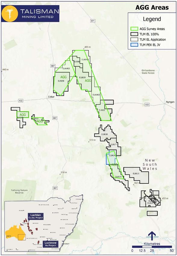
Figure 2: Talisman's FALCON® AGG survey area.

                                                4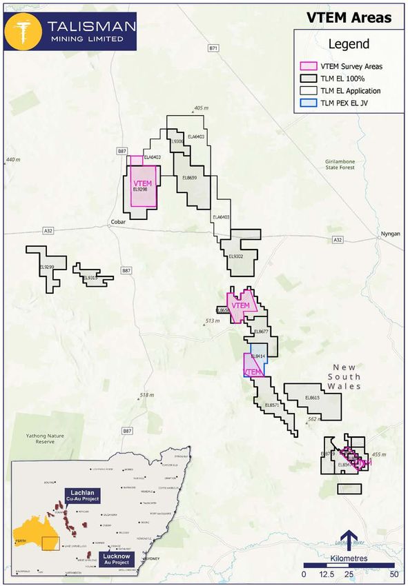
Targeted Airborne Electromagnetic Survey (AEM) Survey
In conjunction with the regional FALCON® AGG survey, Talisman has contracted UTS Geophysics
Pty Ltd to undertake a targeted Airborne Electro-Magnetic (AEM) survey using the VTEM™ Max
helicopter-borne AEM system (Figure 3).

Figure 3: VTEM Max helicopter-borne AEM system in operation.

Electro-Magnetic surveys have been the key discovery tool for many deposits in the Cobar area
through the identification of concealed conductive anomalies associated with massive sulphide
orebodies. This includes the recent discoveries of Peel Mining Limited’s Mallee Bull polymetallic (Cu-
Ag-Au-Pb-Zn) deposit and Aeris Resources Ltd’s Constellation copper deposit.

The AEM survey is planned to fly 6,285-line kilometres covering four blocks over Talisman’s NSW
exploration portfolio (refer Figure 4), targeted at areas assessed as having the highest potential for
sulphide orebodies. The survey scope also includes three prospective areas of interest identified
during the conceptual review conducted by exploration expert Dr Jon Hronsky over Talisman’s
exploration portfolio in mid-2021 1.

A recent review of the survey scope by technical personnel and consultants familiar with the area
resulted in the planned survey area being modified from the area previously announced 2 to focus on
geologically permissible tenure containing mineral system components, in order to maximise
Talisman’s opportunity to detect a significant anomaly associated with a mineralised system.

The survey will now cover five of Talisman’s Exploration Licences and part of one Exploration
Licence Application at the Lachlan Project: EL8414 (TLM 87%), EL8547, EL8658, EL8680, EL8719,
EL9299 and ELA6403 respectively. The AEM survey is also scheduled to commence in the last week

1
    Refer Talisman ASX announcement dated 30 July 2021
2
    Refer Talisman ASX announcement dated 7 October 2021

                                                                                                         5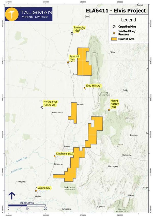
of January 2022 and should take approximately five to six weeks to complete, subject to favourable
weather conditions.

        Figure 4: Talisman's VTEM™ Max helicopter-borne AEM survey area.

                                                                                                     6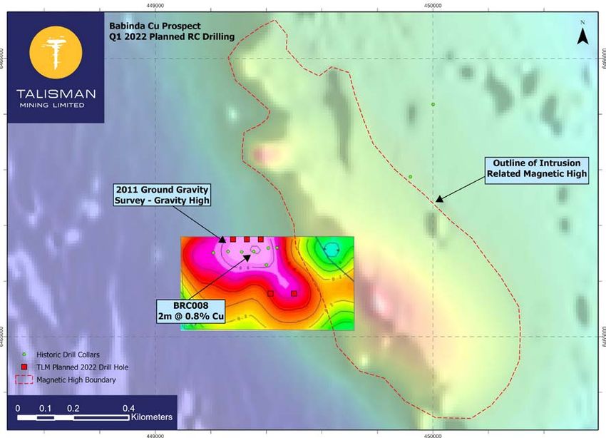
RC Drilling Program

Talisman has also contracted NSW-based exploration drilling contractor, Resolution Drilling Pty Ltd,
to undertake a 7,000m RC drilling program on four highly prospective target areas. All NSW
regulatory approvals have now been received for this program, which is scheduled to commence
just prior to the start of the two regional-scale geophysical surveys. Details of the four target areas
to be tested are provided below.

Kaolin Shaft Gold Prospect (EL8680 – TLM 100%)
Previous regolith sampling by Talisman along an interpreted south-eastern extension of the Mineral
Hill Corridor (hosting the polymetallic Mineral Hill mine) highlighted multiple gold-in-soil anomalies in
this area (Figure 5) 3. Historic work in this area has indicated the presence of base metal sulphides
and gold, however it failed to systematically test the trend beyond an average drilling depth of 96m.
Drilling of this highly prospective trend across three systematic section lines (refer Figure 5) will
provide a test of the deeper mineral potential of the significant gold-in-soils anomaly. Regulatory
approvals have been received which will enable drilling to occur across the most significant gold-in-
soil anomaly located in the north-west trending Mineral Hill Corridor.

    Figure 5: Kaolin Shaft planned RC collars over gridded gold-in-soils assays.

3
    Refer Talisman ASX announcement dated 22 July 2019 for full details including JORC tables

                                                                                                            7
Carpina North Gold Prospect (EL8571 – TLM 100%)
Soil sampling completed by Talisman during 2020 and 2021 identified a significant broad zone of
gold anomalism at the Carpina North Prospect covering a total area of 1km x 1.5km 4 (Figure 6). It is
interpreted that the mineralisation is controlled by a number of north-northwest trending structures
arranged in a north-east-trending en-echelon structure.
Mapping undertaken by previous explorers at the Carpina North Prospect identified silica alteration
bands trending in a north-south orientation. Such silica alteration is commonly associated with gold-
bearing hydrothermal fluids. The identified gold-in-soil anomaly and potential gold mineralisation is
hosted within a folded sequence of Ordovician sedimentary lithologies. No previous drilling has been
undertaken over the Carpina North gold-in-soil anomaly to date.
NSW regulatory approvals have been received for a 20-hole RC drill program at Carpina North with
drilling scheduled to commence at the completion of the Kaolin Shaft and Murray’s Mine drill
programs.

                         Figure 6: Carpina North gold prospect showing soil anomaly and proposed RC drill-hole locations.

4
    Refer Talisman ASX announcement dated 6 May 2021 for full details including JORC tables

                                                                                                                            8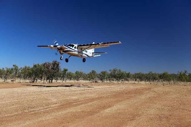
Murray’s Mine Gold Prospect (EL8719 – TLM 100%)
The Murray’s Mine gold prospect has seen drilling from previous explorers who conducted limited
exploration around historic workings and along a mineralised trend to the north-west. Grab samples
collected by Talisman’s exploration team indicate brecciated quartz veining with weathered
sulphides are present in a quartz-mica schist, whilst historic drilling contains gold intercepts in excess
of 10g/t Au.
A review of soil and auger sampling conducted by Talisman in 2019 5 has identified gold-in-soil
anomalies to the east of previous work, suggesting that mineralisation may trend in a north-northeast
direction from old workings and was missed by previous explorers (refer Figure 7). A reconnaissance
RC drill program of six holes will test for the presence of deeper, steeply-dipping mineralisation,
confirm the continuity of mineralisation intersected by historic drilling and also test the north-
northeast trending gold-in-soil anomaly for the presence of additional gold-bearing veins.

                   Figure 7: Murrays Mine Gold prospect showing soil anomaly, drilling and soil trends and
                   proposed RC drill-hole locations.

5
    Refer ASX Announcement dated 28 October 2019

                                                                                                             9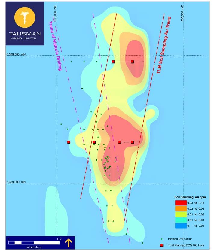
Babinda Copper Prospect (EL8659 – TLM 100%)
The Babinda Copper Prospect is located in an area of old workings near the historic Babinda and
Elaine Copper Mines. The area has been subject to limited exploration, and no historic drilling below
100m. Holes drilled by previous explorers encountered encouraging base metal intersections
including 2m @ 0.8% Cu (BRC008) 6 with associated Zn-Pb-Ag tenors through the drilling area
however, no follow up was ever conducted. Best intercepts in historic drilling were associated with
a distinct gravity high identified from ground gravity surveys.
Five reconnaissance RC holes are planned to 250m depth, testing for base metal potential along
strike of the historic drilling and also testing the gravity anomaly to depth (Figure 8). This gravity high
is located on the western margin of a broad magnetic anomaly suggestive of a deeper intrusive
source of mineralizing fluids.
In addition, the regional targeting review commissioned by Talisman and undertaken by exploration
expert, Dr Jon Hronsky, delineated a conceptual base metal target area in the north-west of the
tenement associated with the interpreted intersection between the north-northwest striking Kurrallee
Fault and a conceptual set of interpreted north-east striking second order structures.
As the area is concealed beneath transported cover, two reconnaissance RC holes will be drilled in
this area targeting the intersection of the Kurrallee Fault and second order structures to ascertain
the nature and type of basement lithologies and the mineralised potential of these structures This
area will also be surveyed as part of Talisman’s regional AEM survey, targeting conductive
anomalies hosted in basement rocks as indicators of blind massive sulphide bodies.

            Figure 8: Babinda Copper Prospect gravity and magnetic Imagery, historic6 and planned drilling.

6
    Refer RE0003828, Combined Seventh Annual and Final Report for EL6338, Babinda Project for the period 9 November 2010 to 8 November 2011.

                                                                                                                                               10
Additional Project Area – Elvis Project
Talisman has submitted an Exploration Licence Application (ELA6411) for an area of recently vacant
ground to the east and north-east of the town of Parkes, NSW. The area is highly prospective, with
multiple active, developing and historic gold deposits in the area including Alkane Resources’
Tomingley and Peak Hill gold mines, and the Northparkes Cu-Au-Ag Mine (Figure 9).
Geologically, the application area contains Ordovician, Silurian and Devonian volcanics and
intrusives subject to significant deformation in the Parkes and Coolac-Narromine Fault Zones.
Talisman considers this area to be highly prospective for Ordovician-Silurian porphyry-epithemal
copper-gold and orogenic gold deposit models.
The application was first in line against competitor applications and if granted an Exploration Licence
by the NSW Resource Regulator in satisfaction of the application, will form the Elvis Project,
increasing Talisman’s exposure to highly prospective areas of NSW.
Figure 9: ELA6411 application area and surrounding mines and resources.
11NSW Exploration Team Expansion
Talisman is also pleased to advise that recruitment activities have been concluded and, as a result,
three full-time geologists have been employed dedicated to its NSW projects.
These personnel are based in Victoria and New South Wales, which will minimise disruption
associated with travel to and from the project areas. With over 50 years of combined experience
across a range of geological roles with major to junior companies between them, the new geological
employees are extremely well qualified to make a significant contribution to the Company’s success
moving forward.
COVID-19 Management
All exploration activities will be conducted under, and closely managed in accordance with,
Talisman’s COVID-19 policies and procedures and NSW COVID-19 regulatory requirements, to
ensure the safety of Talisman employees, contractors and host communities. Talisman’s COVID-19
procedures include regular COVID-19 rapid antigen testing prior to and during field work in project
areas, the availability and use of appropriate COVID-19 PPE and maintaining social distancing
protocols wherever practical.
Ends
For further information, please contact:
Shaun Vokes – CEO Nicholas Read (Media inquiries)
on +61 8 9380 4230 on +61 419 929 046
This release has been authorised by the Board of Talisman Mining Limited.
12About Talisman Mining
Talisman Mining Limited (ASX:TLM) is an Australian mineral development and exploration company. The Company’s aim is to
maximise shareholder value through exploration, discovery and development of complementary opportunities in base and
precious metals.
Talisman has secured tenements in the Cobar/Mineral Hill region in Central NSW through the grant of its own Exploration Licenses
and through a joint venture agreement. The Cobar/Mineral Hill region is a richly mineralised district that hosts several base and
precious metal mines including the CSA, Tritton, and Hera/ Nymagee mines. This region contains highly prospective geology that
has produced many long-life, high-grade mineral discoveries. Talisman has identified a number of areas within its Lachlan Cu-Au
Project tenements that show evidence of base and precious metals endowment which have had very little modern systematic
exploration completed to date. Talisman believes there is significant potential for the discovery of substantial base metals and
gold mineralisation within this land package and is undertaking active exploration to test a number of these targets.
Talisman also has a majority participating interest in a joint venture with privately-owned Lucknow Gold Limited in relation to the
Lucknow Gold Project (EL6455) in New South Wales. The Lucknow Goldfield was discovered in 1851 and was one of the earliest
goldfields to be mined commercially in Australia. Historic production records at the Project are incomplete, however in excess of
400,000 ounces of gold has reportedly been produced at grades of 100 to 200 g/t gold 7.Very little modern exploration has been
completed outside of the existing mine workings and Talisman intends to undertake a program of geochemical surface sampling
and mapping at the Project ahead of a drilling program to test for potential down plunge extensions of the high-grade gold ore
shoots and repeat structures throughout the Project area.
Competent Person’s Statement
Information in this announcement that relates to Exploration Results and Exploration Targets is based on, and fairly represents
information and supporting documentation complied by Mr Russ Gregory, who is a member of the Australasian Institute of
Geoscientists. Mr Gregory is a full-time employee of Talisman Mining Ltd and has sufficient experience which is relevant to the
style of mineralisation and types of deposits under consideration and to the activities undertaken to qualify as a Competent Person
as defined in the 2012 Edition of the “Australasian Code for Reporting of Exploration Results, Mineral Resources and Ore
Reserves”. Mr Gregory has reviewed the contents of this announcement and consents to the inclusion in this announcement of
all technical statements based on his information in the form and context in which they appear.
Forward-Looking Statements
This ASX release may include forward-looking statements. These forward-looking statements are not historical facts but rather
are based on Talisman Mining Ltd.’s current expectations, estimates and assumptions about the industry in which Talisman Mining
Ltd operates, and beliefs and assumptions regarding Talisman Mining Ltd.’s future performance. Words such as “anticipates”,
“expects”, “intends”, “plans”, “believes”, “seeks”, “estimates”, “potential” and similar expressions are intended to identify forward-
looking statements. Forward-looking statements are only predictions and are not guaranteed, and they are subject to known and
unknown risks, uncertainties and assumptions, some of which are outside the control of Talisman Mining Ltd. Past performance
is not necessarily a guide to future performance and no representation or warranty is made as to the likelihood of achievement or
reasonableness of any forward-looking statements or other forecast. Actual values, results or events may be materially different
to those expressed or implied in this presentation. Given these uncertainties, recipients are cautioned not to place reliance on
forward looking statements. Any forward looking statements in this announcement speak only at the date of issue of this
announcement. Subject to any continuing obligations under applicable law and the ASX Listing Rules, Talisman Mining Ltd does
not undertake any obligation to update or revise any information or any of the forward looking statements in this announcement
or any changes in events, conditions or circumstances on which any such forward looking statement is based.
7
NSW DIGS report, First Annual Exploration Report EL5770, 2001 -R00030162
13Appendix 1
Lachlan Copper- Gold Project Tenure
14Appendix 2
JORC Tables Section 1 & 2
Section 1 Sampling Techniques and Data
(Criteria in this section apply to all succeeding sections)
Criteria JORC Code explanation Commentary
Sampling • Nature and quality of sampling (e.g. cut • No new drilling results are reported in this release.
techniques channels, random chips, or specific specialised
industry standard measurement tools
appropriate to the minerals under investigation,
such as down-hole gamma sondes, or
handheld XRF instruments, etc.). These
examples should not be taken as limiting the
broad meaning of sampling.
• Include reference to measures taken to
ensure sample representivity and the
appropriate calibration of any measurement
tools or systems used.
• Aspects of the determination of mineralisation
that are Material to the Public Report. In cases
where ‘industry standard’ work has been done
this would be relatively simple (e.g. ‘reverse
circulation drilling was used to obtain 1 m
samples from which 3kg was pulverised to
produce a 30 g charge for fire assay’). In other
cases, more explanation may be required, such
as where there is coarse gold that has inherent
sampling problems. Unusual commodities or
mineralisation types (e.g. submarine nodules)
may warrant disclosure of detailed information.
Drilling • Drill type (e.g. core, reverse circulation, open- •
techniques hole hammer, rotary air blast, auger, Bangka,
sonic, etc) and details (e.g. core diameter,
triple or standard tube, depth of diamond tails,
face-sampling bit or other type, whether core is
oriented and if so, by what method, etc).
Drill sample • Method of recording and assessing core and •
recovery chip sample recoveries and results
assessed.
• Measures taken to maximise sample
recovery and ensure representative nature of
the samples.
• Whether a relationship exists between
sample recovery and grade and whether
sample bias may have occurred due to
preferential loss/gain of fine/coarse material.
Logging • Whether core and chip samples have been •
geologically and geotechnically logged to a
level of detail to support appropriate Mineral
Resource estimation, mining studies and
metallurgical studies.
• Whether logging is qualitative or quantitative
in nature. Core (or costean, channel, etc.)
photography.
• The total length and percentage of the
relevant intersections logged.
Sub-sampling • If core, whether cut or sawn and whether •
techniques quarter, half or all core taken.
and sample • If non-core, whether riffled, tube sampled,
preparation rotary split, etc. and whether sampled wet or
dry.
15Criteria JORC Code explanation Commentary
• For all sample types, the nature, quality and
appropriateness of the sample preparation
technique.
• Quality control procedures adopted for all
sub-sampling stages to maximise
representivity of samples.
• Measures taken to ensure that the sampling
is representative of the in-situ material
collected, including for instance results for
field duplicate/second-half sampling.
• Whether sample sizes are appropriate to the
grain size of the material being sampled.
Quality of • The nature, quality and appropriateness of •
assay data the assaying and laboratory procedures used
and laboratory and whether the technique is considered
tests partial or total.
• For geophysical tools, spectrometres,
handheld XRF instruments, etc, the
parametres used in determining the analysis
including instrument make and model,
reading times, calibrations factors applied
and their derivation, etc.
• Nature of quality control procedures adopted
(e.g. standards, blanks, duplicates, external
laboratory checks) and whether acceptable
levels of accuracy (i.e. lack of bias) and
precision have been established.
Verification of • The verification of significant intersections by •
sampling and either independent or alternative company
assaying personnel.
• The use of twinned holes.
• Documentation of primary data, data entry
procedures, data verification, data storage
(physical and electronic) protocols.
• Discuss any adjustment to assay data.
Location of • Accuracy and quality of surveys used to •
data points locate drill-holes (collar and down- hole
surveys), trenches, mine workings and other
locations used in Mineral Resource
estimation.
• Specification of the grid system used.
• Quality and adequacy of topographic control.
Data spacing • Data spacing for reporting of Exploration •
and Results.
distribution
• Whether the data spacing and distribution is
sufficient to establish the degree of
geological and grade continuity appropriate
for the Mineral Resource and Ore Reserve
estimation procedure(s) and classifications
applied.
• Whether sample compositing has been
applied.
Orientation of • Whether the orientation of sampling achieves •
data in relation unbiased sampling of possible structures and
to geological the extent to which this is known, considering
structure the deposit type.
• If the relationship between the drilling
orientation and the orientation of key
16Criteria JORC Code explanation Commentary
mineralised structures is considered to have
introduced a sampling bias, this should be
assessed and reported if material.
Sample • The measures taken to ensure sample • RC samples were stored on site at the Lachlan
security security. CopperGold Project prior to submission under the
supervision of the Senior Project Geologist. Samples were
transported to ALS Chemex Laboratories Orange by an
accredited courier service
Audits or • The results of any audits or reviews of • No external audits or reviews of the sampling techniques
reviews sampling techniques and data. and data have been completed.
Section 2 Reporting of Exploration Results
(Criteria listed in the preceding section also apply to this section)
Criteria JORC Code explanation Commentary
Mineral • Type, reference name/number, location and • The Lachlan Copper Gold Project currently comprises
tenement and ownership including agreements or material 15 granted exploration licences:
land tenure issues with third parties such as joint ventures,
status partnerships, overriding royalties, native title o EL8414 held in joint venture by Haverford (87%
interests, historical sites, wilderness or participating interest) and Peel Mining Limited (13%
national park and environmental settings. participating interest) (Refer Talisman ASX
announcement 20 October 2020 for full details); and
• The security of the tenure held at the time of
reporting along with any known impediments o EL8547, EL8571, EL8615, EL8658, EL8659,
to obtaining a licence to operate in the area. EL8677, EL8680, EL8719, EL9298, EL9299,
EL9302, EL9306, EL9315, and EL9324 held 100%
by Haverford.
• There are no known Native Title Claims over the
Lachlan Copper-Gold Project.
• All tenements are in good standing and there are no
existing known impediments to exploration or mining.
Exploration • Acknowledgment and appraisal of exploration • The Lachlan Copper-Gold Project has been subject to
done by other by other parties. exploration by numerous previous explorers.
parties
• Exploration work on has included diamond, RC and Air
Core drilling, ground and down-hole EM surveys, soil
sampling, geological interpretation and other
geophysics (magnetics, gravity).
Geology • Deposit type, geological setting and style of • The Lachlan Copper-Gold Project lies within the Central
mineralisation. Lachlan Fold belt in NSW.
• The Lachlan Copper-Gold Project is considered
prospective for epithermal style base-metal and
precious metal mineralisation, orogenic mineralisation,
and Cobar style base-metal mineralisation.
Drill-hole • A summary of all information material to the • Historical drilling intercepts have been appropriately
Information understanding of the exploration results referenced to source information.
including a tabulation of the following
information for all Material drill-holes:
• easting and northing of the drill-hole collar
• elevation or RL (Reduced Level –
elevation above sea level in metres) of the
drill-hole collar
• dip and azimuth of the hole
• down hole length and interception depth
• hole length.
17Criteria JORC Code explanation Commentary
• If the exclusion of this information is justified
on the basis that the information is not
material and this exclusion does not detract
from the understanding of the report, the
Competent Person should clearly explain why
this is the case.
Data
aggregation • In reporting Exploration Results, weighting • Significant intersections reported from the Lachlan
methods averaging techniques, maximum and/or Copper-Gold Project are based on a nominal 0.25g/t
minimum grade truncations (e.g. cutting of Au, 0.25% Cu, 5g/t Ag, or 1% Zn cutoff, no more than
high grades) and cut-off grades are usually 3m of internal dilution and a minimum composite grade
material and should be stated. of 0.25g/t Au, 0.25% Cu, or 5g/t Ag, or 1% Zn.
• Where aggregate intercepts incorporate short • Cu and Au grades used for calculating significant
lengths of high grade results and longer intersections are uncut.
lengths of low grade results, the procedure
used for such aggregation should be stated • All results reported in this document have been derived
and some typical examples of such from 1m split samples.
aggregations should be shown in detail.
• Length weighted intercepts are reported for mineralised
• The assumptions used for any reporting of intersections.
metal equivalent values should be clearly
stated.
Relationship • These relationships are particularly important • Drill-holes relating to the Lachlan Copper-Gold Project
between in the reporting of Exploration Results. are reported as down hole intersections. True widths of
mineralisation • If the geometry of the mineralisation with reported mineralisation are not known at this time.
widths and respect to the drill-hole angle is known, its
intercept nature should be reported.
lengths • If it is not known and only the down hole
lengths are reported, there should be a clear
statement to this effect (e.g. ‘down hole length,
true width not known’).
Diagrams • Appropriate maps and sections (with scales) • Appropriate maps with scale are included within the
and tabulations of intercepts should be body of the accompanying document.
included for any significant discovery being
reported These should include, but not be
limited to a plan view of drill-hole collar
locations and appropriate sectional views.
Balanced • Where comprehensive reporting of all • Contouring of geochemical assay and pXRF data
reporting Exploration Results is not practicable, provides an appropriate representation of the results
representative reporting of both low and high • The accompanying document is considered to represent
grades and/or widths should be practiced to a balanced report.
avoid misleading reporting of Exploration
Results.
Other • Other exploration data, if meaningful and • All meaningful and material information is reported.
substantive material, should be reported including (but
exploration not limited to): geological observations;
data geophysical survey results; geochemical
survey results; bulk samples – size and
method of treatment; metallurgical test
results; bulk density, groundwater,
geotechnical and rock characteristics;
potential deleterious or contaminating
substances.
18Criteria JORC Code explanation Commentary
Further work • The nature and scale of planned further work • Planned future work at the Lachlan Copper-Gold Project
(e.g. tests for lateral extensions or depth includes soil sampling, RC/ diamond drilling and
extensions or large-scale step-out drilling). geophysical surveys.
• Diagrams clearly highlighting the areas of
possible extensions, including the main
geological interpretations and future drilling
areas, provided this information is not
commercially sensitive.
19You can also read