MARINE ACCIDENT INVESTIGATION REPORT - MA2021-3
←
→
Page content transcription
If your browser does not render page correctly, please read the page content below
MA2021-3

  MARINE ACCIDENT
INVESTIGATION REPORT

      March 25, 2021
The objective of the investigation conducted by the Japan Transport Safety Board in
accordance with the Act for Establishment of the Japan Transport Safety Board is to determine the
causes of an accident and damage incidental to such an accident, thereby preventing future accidents
and reducing damage. It is not the purpose of the investigation to apportion blame or liability.

                                                              TAKEDA Nobuo
                                                              Chairperson
                                                              Japan Transport Safety Board

                                                     Note:
          This report is a translation of the Japanese original investigation report. The text in Japanese
shall prevail in the interpretation of the report.
MARINE ACCIDENT INVESTIGATION REPORT

Vessel type and name:     Roll-on/Roll-off Cargo Ship PANSTAR GENIE
IMO number:               9248227
Gross tonnage:            13,682 tons

Vessel type and name:     Tugboat DAITOUMARU
Vessel Number:            230-33698 Tokyo (Ship Inspection Completion Slip Number)
Gross tonnage:            19.28 tons

Accident type:            Collision
Date and time:            Around 19:25, June 10, 2019
Location:                 Keihin Port, Tokyo Section 3
                          Around 347° true bearing, 950 m from the Tokyo West Breakwater
                          Lighthouse
                          (Approximately 35°35.6′ N, 139°46.9′ E)

                                                                                March 3, 2021
                                             Adopted by the Japan Transport Safety Board
                                                  Chairperson TAKEDA Nobuo
                                                  Member            SATO Yuji
                                                  Member            TAMURA Kenkichi
                                                  Member            KAKISHIMA Yoshiko
                                                  Member            OKAMOTO Makiko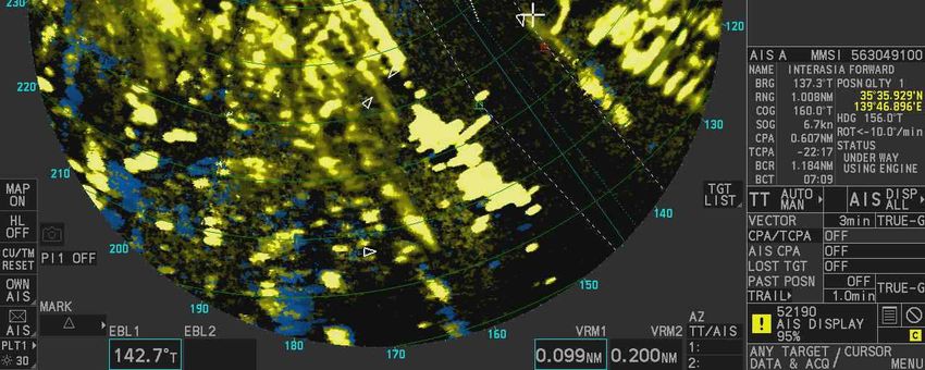
SYNOPSIS

  Roll-on/roll-off cargo ship PANSTAR GENIE, with her master and 16 other crew members on board (seven
nationals of the Republic of Korea and nine nationals of the Republic of the Philippines), left the Shinagawa
Wharf, Tokyo Section 2, Keihin Port, and was proceeding southeast to Nagoya Port, Aichi Prefecture, while
tugboat DAITOUMARU, with her captain alone, was proceeding southeast toward Daikoku Wharf,
Yokohama Section, Keihin Port after she departed from Shibaura Landing Stage, Tokyo Section 2, Keihin
Port. At around 19:25 on June 10, 2019, the two vessels collided in the vicinity of the northern end of the
Tokyo West Passage, Tokyo Section 3, Keihin Port.
  PANSTAR GENIE suffered abrasions on her port and starboard bow's shell plating and DAITOUMARU
suffered fractures and other damages on her mast, but there were no casualties on either vessel.

   It is probable that the accident occurred when PANSTAR GENIE and DAITOUMARU were both
proceeding southeast, PANSTAR GENIE approached from the stern, gradually sped up, and continued to
navigate parallel without noticing DAITOUMARU navigating near her bow at twilight after sunset in Tokyo
Section 3 at Tokyo Port under the condition whereby it became dark and difficult to see in the surroundings
due to heavy rain. It is probable that both vessels collided because DAITOUMARU also continued navigating
at a constant speed without noticing that PANSTAR GENIE was proceeding southeast after she departed.
  It is probable that PANSTAR GENIE continued her navigation without noticing DAITOUMARU because
the surroundings were dark and the visibility was poor due to the influence of heavy rain. On top of that,
DAITOUMARU was a small vessel approaching PANSTAR GENIE from her stern, and after she navigated
within the minimum detection distance of PANSTAR GENIE's radar, she navigated inside the blind spot from
PANSTAR GENIE's wheelhouse.
  It is probable that the fact that PANSTAR GENIE dismissed her crew members from departure stations
and began proceeding southeast under the condition of poor visibility due to the influence of heavy rain, might
have contributed to PANSTAR GENIE not being able to notice DAITOUMARU.
  It is probable that the reason why Master B did not monitor PANSTAR GENIE's movements and continued
with the navigation was, from the first time he noticed PANSTAR GENIE, he assumed that she was an
incoming vessel mooring at the Shinagawa Wharf.
  It is probable that the noise from DAITOUMARU's main engine and the sound of rainfall at the time of
the accident might have caused Master B not to notice that PANSTAR GENIE was approaching.

                                                   - 1 -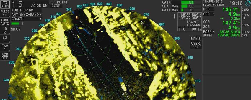
1 PROCESS AND PROGRESS OF THE INVESTIGATION

1.1 Summary of the Accident
  Roll-on/roll-off cargo ship PANSTAR GENIE, with her master and 16 other crew members on board
(seven nationals of the Republic of Korea and nine nationals of the Republic of the Philippines), left the
Shinagawa Wharf, Tokyo Section 2, Keihin Port, and was proceeding southeast to Nagoya Port, Aichi
Prefecture, while tugboat DAITOUMARU, with her captain alone, was proceeding southeast toward Daikoku
Wharf, Yokohama Section, Keihin Port after she departed from Shibaura Landing Stage, Tokyo Section 2,
Keihin Port. At around 19:25 on June 10, 2019, the two vessels collided in the vicinity of the northern end of
the Tokyo West Passage, Tokyo Section 3, Keihin Port.
  PANSTAR GENIE suffered abrasions on her port and starboard bow's shell plating and DAITOUMARU
suffered fractures and other damages on her mast, but there were no casualties on either vessel.

 1.2 Outline of the Accident Investigation
 1.2.1 Setup of the Investigation
 The Japan Transport Safety Board appointed an investigator-in-charge and a marine accident investigator to
investigate this accident on June 12, 2019.

 1.2.2 Collection of Evidence
 June 17, July 1, 3, 8, 29, November 25, 2019 On-site investigation and interviews
 August 16, 20, 23, 2019 On-site investigation
 November 14, 17, December 5 and 21, 2019 Collection of questionnaires

 1.2.3 Test and Research by Other Institutes
 ANALYSIS CENTER CO., LTD. was entrusted for the evaluation of this accident by conducting an
identification test using infrared spectroscopy (structural component examination method) from the coating
paint that was collected from PANSTAR GENIE's hull and the fragment scattered on DAITOUMARU's board.

 1.2.4 Comments of Parties Relevant to the Cause
 Comments on the draft report were invited from parties relevant to the cause of the accident.

 1.2.5 Comments from Flag State
 Comments on the draft report were invited from the flag state of PANSTAR GENIE.

                                                   - 2 -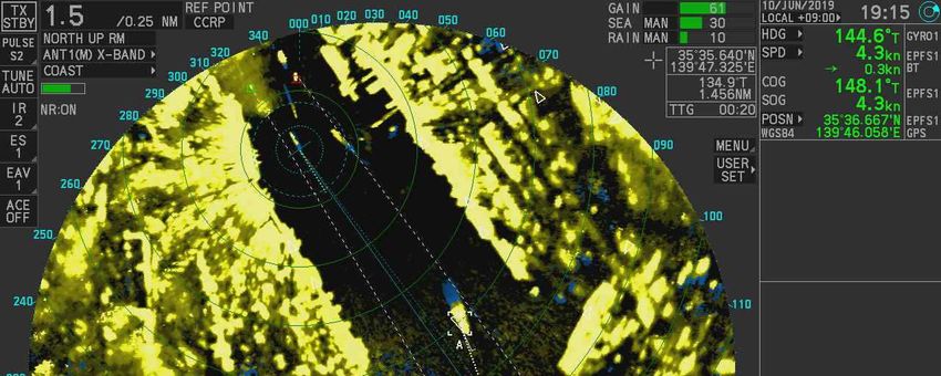
2 FACTUAL INFORMATION

2.1         Events Leading to the Accident
    2.1.1      The Navigation Track of PANSTAR GENIE According to the AIS Data
       According to the information received by a private information company from the 'Automatic
     Identification System (AIS)1 of PANSTAR GENIE (hereinafter referred to as "Vessel A"), the navigational
     track record of Vessel A from 18:55:53 to 19:25:54 on June 10, 2019, was as shown in Table 1.
       Vessel A's position was based on the position of the GPS antenna mounted above the bridge, and the
     GPS antenna's position was 76 m from the bow, 85 m from the stern, 16 m from the port side, and 8 m from
     the starboard side. Moreover, the course over the ground and the ship's position are in true bearing
     (hereinafter the same).

                                   Table 1 AIS Record of Vessel A (Excerpt)
                                                                                Course
                                                                                                            Speed over
                                          Ship’s position                      over the       Heading
              Time                                                                                          the Ground2
                                                                               Ground
       (HH:MM:SS)
                               Latitude (N)            Longitude(E)
                                                                                  (°)            (°)       (Knots(kn))
                                  (°- ′-″)                  (°- ′-″)
             18:55:53           35-37-31.3               139-45-35.0            350.0            358              0.0
             18:56:53           35-37-31.3               139-45-35.1            350.0            357             -0.1
             18:57:53           35-37-31.3               139-45-35.3            069.8            353             -0.2
             18:58:43           35-37-31.3               139-45-35.7            095.4            351             -0.3
             18:59:53           35-37-31.3               139-45-35.9            093.9            347             -0.2
             19:00:54           35-37-31.3               139-45-36.0            157.6            343             -0.4
             19:01:54           35-37-29.3               139-45-36.7            162.8            339             -3.7
             19:02:54           35-37-25.6               139-45-38.4            157.8            329             -3.7
             19:03:54           35-37-22.4               139-45-40.3            151.1            318             -3.3
             19:04:54           35-37-19.9               139-45-42.2            143.8            304             -2.8
             19:05:54           35-37-18.1               139-45-44.2            134.6            288             -2.4
             19:06:54           35-37-16.7               139-45-46.5            121.1            269             -2.2

1 Automatic Identification System (AIS) is a device that each vessel uses to automatically transmit and receive information
such as vessel identification code, ship type, name, position, course, speed, destination, and conditions of navigation, and to
exchange information with other vessels or land-based navigation aids.
2 “Speed over the ground” refers to the speed of a vessel as measured against one point on the earth’s surface. The speed of a

vessel measured against the water in which the vessel is traveling is called “speed over water”.

                                                           - 3 -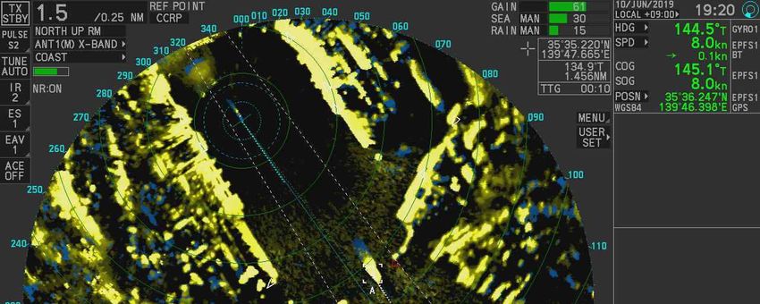
19:07:54             35-37-16.2             139-45-49.3            094.7           249             -2.4
          19:08:54             35-37-15.9             139-45-51.0            106.5           228             -0.8
          19:09:54             35-37-14.6             139-45-50.8            193.9           192              2.1
          19:10:54             35-37-10.3             139-45-51.4            164.8           164              6.1
          19:11:55             35-37-02.3             139-45-54.0            164.5           164              9.0
          19:12:54             35-36-54.7             139-45-56.6            164.5           165              7.4
          19:13:55             35-36-48.4             139-45-58.9            163.4           162              5.9
          19:14:53             35-36-43.7             139-46-01.0            156.5           151              4.7
          19:15:53             35-36-39.8             139-46-03.6            148.1           145              4.3
          19:16:53             35-36-35.8             139-46-06.8            147.2           145              5.4
          19:17:53             35-36-30.6             139-46-10.9            147.0           145              6.6
          19:18:53             35-36-24.6             139-46-15.7            146.4           145              7.3
          19:19:54             35-36-18.1             139-46-21.1            145.6           145              7.8
          19:20:54             35-36-11.6             139-46-26.6            145.0           145              8.1
          19:21:54             35-36-04.8             139-46-32.4            145.4           145              8.3
          19:22:54             35-35-58.2             139-46-38.2            144.7           145              8.2
          19:23:43             35-35-52.4             139-46-43.0            145.7           146              8.6
          19:24:43             35-35-44.6             139-46-49.9            144.7           145            10.4
          19:25:54             35-35-34.1             139-46-59.4            141.1           140            11.4

    2.1.2 Voice and Sound from the Navigation Room of Vessel A
      The voices and sounds recorded on Vessel A's Voyage Data Recorder3 (hereinafter referred to as "VDR")
from 19:00:35 to 20:28:40 were as shown in Table 2.
     The speakers in this conversation were crew members of Vessel A, namely the master (hereinafter referred
to as "Master A"), the officer (hereinafter referred to as "Officer A1"), another officer (hereinafter referred
to as "Officer A2") and the quartermaster. The sounds of the engine telegraph and opening or closing of doors,
etc. are also shown on the table.

3 “Voyage Data Recorder (VDR)” refers to a device that can record a ship’s position, course, speed, radar information, and
other data related to navigation, as well as communications by VHF radio telephone and voice communication on the bridge,
among others.

                                                        - 4 -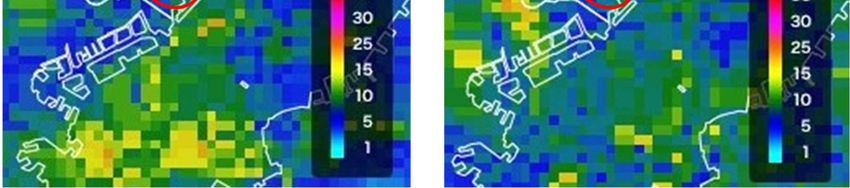
Table 2 Voice and Sound Record on VDR (Excerpt)
      Time                              Voice and Sound Recorded
 (HH:MM:SS)
19:00:35~     Master A:Half astern.
19:00:39      Officer A2:Half astern.
              Officer A2:Half astern, sir.
19:02:41      Port side wing sliding door closing sound
19:04:30      Master A:Port 10.
              Quartermaster:Port 10.
19:07:35~     Master A:Stop engine.
19:07:37      Officer A2:Stop engine.
              Engine telegraph sound
19:07:43~     Master A:Slow ahead.
19:07:49      Officer A2:Slow ahead.
              Engine telegraph sound
              Officer A2:Slow ahead, sir.
19:08:27      Wheelhouse's back door opening and closing sound
19:09:00~     Officer A2:Tokyo port radio, This is Panstar Genie calling.
19:10:31      The conversation was then followed by the communication with the Tokyo Port
              Radio about the vessel's departure
19:15:11~     Master A:One four five.
19:15:25      Quartermaster:One four five.
              Quartermaster:One four five, sir."
19:16:08~     Master A:Half ahead.
19:16:14      Officer A2:Half ahead.
              Engine telegraph sound
              Officer A2:Half ahead, sir.
19:19:18      Master A:Auto.
              Quartermaster:Auto.
19:23:27      Master A:Full ahead.

                                        - 5 -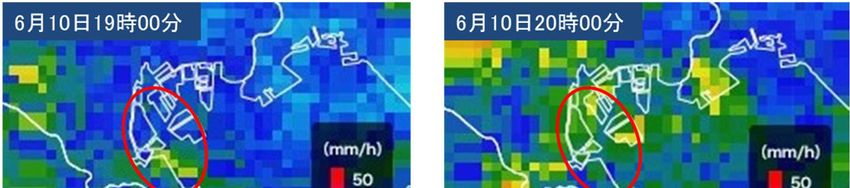
20:14:24              Sound of mobile phone ringing
 20:14:31~             Master A: Yes, yes, excuse me? No, not at all. We did not collide or anything like
 20:16:00              that. There was no call from the Yokohama Port Radio. We also did not talk to the
                       Yokohama Coast Guard.
 20:27:16              Matsunami:Panstar Genie, Panstar Genie, this is patrol vessel, Japan Coast Guard
                       patrol vessel Matsunami. How do you read me?

 20:27:38~             Master A: Matsunami, I read you. Over.
 20:28:40              Matsunami: This is Matsunami. Did you collide with a small boat when you
                       departed? Over. We would like to confirm with your vessel, could you enter the
                       Nakanose anchorage? Over.
                       Master A: Yes, sir. We have decreased our engine speed. We will proceed
                       according to your instructions.

2.1.3    Events Leading to the Accident according to Statements of Crew Members, etc.
          According to the statements by Master A, Officer A1, Officer A2, the representative from Vessel
        A's agency (hereinafter referred to as "Company A1"), and the master (hereinafter referred to as
        "Master B") of DAITOUMARU (hereinafter referred to as "Vessel B"), as well as the reply to the
        questionnaires by Company A1, the events leading to the accident were as follows.
  (1)     Vessel A
          Vessel A is a roll-on/roll-off cargo ship carrying containers and towed vehicles loaded with
        containers. Vessel A's navigation course was as follows: every Monday morning she would berth at
        Shinagawa Wharf (hereinafter referred to as "the Wharf") in Tokyo Section 2, Keihin Port, and after
        she finished cargo handling, she would depart on the evening of the same day to Nagoya Port in Aichi
        Prefecture.
          Vessel A, with Master A (Republic of Korea national) and other 16 crew members on board (seven
        nationals of the Republic of Korea and nine nationals of the Republic of the Philippines), entered the
        F Berth of the Wharf at around 08:00 on June 10, berthed on her port side and carried out unloading
        and loading work.
          After Vessel A finished her cargo handling, her crew members were assigned to departure stations,
        and after leaving the Wharf astern while swinging her stern to starboard at around 19:00, she made a
        port turn with slow ahead, headed southeast, and departed for Nagoya Port.
          At around 19:02 Master A, who was commanding the vessel from the port wing, moved to the
        wheelhouse to continue guiding the navigation. He then allocated the quartermaster to steer in front
        of the steering stand, Officer A2 to a lookout and operating the engine telegraph, while under the

                                                  - 6 -
guidance of Officer A1, the boatswain and the ordinary seaman were on the port forecastle. Under
      the guidance of another officer (hereinafter referred to as "Officer A3"), two ordinary seamen were
      on the port stern performing their duties in the departure station and keeping a lookout for the
      surroundings.
        After dismissing the crew members from their departure station at around 19:07, Vessel A
      proceeded southeast on 145° course (true course, hereinafter the same) from Tokyo Section 2 of
      Keihin Port, while gradually increasing her speed.
        Officer A1 moved from the bow to the wheelhouse, and at around 19:08 was appointed to the
      bridge watch duty, Officer A2 left the wheelhouse at around 19:20 after reporting the Tokyo Port
      Radio on the VHF about Vessel A's departure at around 19:09.
       Vessel A continued to navigate and at about 20:14:24, Company A1 called to inquire about her
      collision with another vessel. Vessel A denied that there was any collision, but at around 20:27 the
      Japan Coast Guard inquired about her approach with a small vessel and instructed her to anchor at
      Nakanose anchorage, where she dropped her starboard anchor at around 20:42.
        Master A was notified by the Japan Coast Guard that Vessel B had been proceeding southeast from
      the northeast end of the Wharf and approached Vessel A on her port stern side. He learned that Vessel
      A continued her navigation, unaware that she had collided with Vessel B, which was navigating
      parallel to her port, in the vicinity of Oi Container Wharf.
      (See Figure 1)

                         Vessel B
                                                                       Ordinary Seaman
                                            Ordinary Seaman
             The Wharf

                                              Boatswain Officer A1               Officer A3

                          Vessel A

             Figure 1 The Navigational Track of Vessel A and the position of Vessel B (Around 19:07)
                             and the Departure station on the Deck Section of Vessel A
(2)     Vessel B
        Vessel B, with Master B alone on board, began to navigate on half ahead toward Daikoku Wharf
      in Yokohama Section of Keihin Port after finishing the barge mooring work at Shibaura Landing
      Stage in Tokyo Section 2 of the same port.

                                                 - 7 -
Master B first recognized Vessel A near the northeast end of the Wharf at around 19:07, where she
appeared to be headed to the Wharf. (See Figure 1)
After confirming that no vessels were navigating from the north of the Rainbow Bridge, Master B
shifted his attention to directing Vessel B's navigation. Afterward, he noticed that Vessel A was
parallel to the Wharf and appeared to be stationary, so he thought Vessel A was in the process of
mooring at the Wharf and turned back his attention to the direction of the navigation.
Master B increased up the main engine from half ahead to full ahead, set the speed to just under 9
kn (speed over the ground, hereinafter the same), fixed the course to the offshore of Haneda Airport
with the reference from the GPS receiver's image, and decided to navigate near the Wharf as usual.
While Vessel B was navigating, Master B suddenly felt an impact near her stern at the Oi Container
Wharf, and immediately afterward, Vessel B's hull became partially ridden up on Vessel A's port
bulbous bow, and her hull tilted significantly to the starboard side.
Master B saw the upper part of Vessel A's port bulbous bow through the starboard window and felt
that Vessel B was in danger of being capsized, so he thought of jumping into the seawater from the
port door, but then he felt that the hull was restored to its original state and made hard starboard.
When he increased the speed of the main engine, Vessel B rolled over Vessel A's starboard bulbous
bow, moved to Vessel A's starboard side, and made contact with Vessel A's starboard shell plating,
and suffered fractures and other damages on her mast.
After Vessel A passed the location of the accident, Master B set Vessel B's main engine to neutral
operation, and at around 19:28, he used the AIS vessel information application on his smartphone to
check the name and nationality of Vessel A, which continued navigating at that time. He then
informed the operator of Vessel B (hereinafter referred to as "Company B") that she had collided
with Vessel A and notified the Japan Coast Guard after that.
Master B was informed by the Japan Coast Guard that Vessel A was departing the Wharf and
realized that he was mistaken in thinking that it was an incoming vessel.
The date and time of occurrence of this accident were around 19:25 on June 10, 2019, and the location was
about 347° true bearing, 950 m from Tokyo West Breakwater Lighthouse.
(Attached Figure 1 Overview of the Events Leading to the Accident Occurrence)
2.2 Injuries to Persons
According to the statements of Master A and Master B, there were no casualties in either vessel.
2.3 Damage to Vessels
According to the on-site investigation on the statements of Master A and Master B, the damages of Vessel
- 8 -A and Vessel B were as follows.
2.3.1 Damages to Vessel A
(1) Approximately 2 meters of abrasion and 12 meters of black rubber and white paint adhesion on
the port bow's shell plating.
(2) Approximately 50 meter-long intermittent abrasion on the starboard bow's shell plating.
(See Figure 2)
Port side
Collision traces of black Peeling off of the paint coating due to
rubber and white paint coating abrasions, with red paint adhesion
Starboard side
Figure 2 State of damage to Vessel A
2.3.2 Damages to Vessel B
(1) Fractures on the mast.
(2) Breakages of the starboard light.
(3) Deformation of the wheelhouse, etc.
(4) Dents on the handrail of the starboard stern.
(5) Damages on the propellers.
(See Figure 3)
- 9 -(3) Deformation of the port side
(1) Fractures of the mast,
fallen from its original place State of damage to the mast, starboard light,
wheelhouse, etc. (Taken from the stern side)
(1)
(3)
(4)
(2)
Stern Bow
(2) Breakages of the starboard light
(4) The handrail on the starboard stern Fragments of the blue paint coating was found
was bent to the port side scattered
Figure 3 State of damage to Vessel B
- 10 -2.4 Crew Information
(1) Gender, Age, and Certificate of Competence
① Master A: Male, 62 years old
Nationality: the Republic of Korea (hereinafter referred to as "South Korea")
First Class Deck Officer Certificate (Merchant Vessels only) (issued by South Korea)
Date of Issue: March 2, 2015
Date of Expiry: March 22, 2020
② Officer A1: Male, 32 years old
Nationality: South Korea
Second Class Deck Officer Certificate (Merchant Vessels only) (issued by South Korea)
Date of Issue: June 1, 2017
Date of Expiry: May 31, 2022
③ Officer A2: Male, 30 years old
Nationality: South Korea
Third Class Deck Officer Certificate (Merchant Vessels only) (issued by South Korea)
Date of Issue : December 4, 2014
Date of Expiry: December 3, 2019
④ Quartermaster: Male, 36 years old
Nationality: the Republic of the Philippines
⑤ Master B: Male, 47 years old
First Class Boat's Operator・Personal Water Craft Operator・With Passenger Service
License
Date of Issue: June 1, 2004
Date of Revalidation: May 21, 2019
(Valid until May 31, 2024)
(2) Sea-going Experience, etc.
① Master A
According to the statement of the representative from Company A1, Master A served as the
master of Vessel A from December 2017 for approximately half a year. After that, he boarded
a passenger and cargo boat managed by PANSTAR TREE CO. LTD. (hereinafter referred to as
"Company A2"), the management company of Vessel A, to act as a substitute master when the
master of that vessel took a long term leave.
Master A boarded Vessel A once a month to serve as a master.
Furthermore, Master A could speak fluent Japanese.
② Officer A1
- 11 -According to the statement of Officer A1, he joined Company A2 around 2016, and after
working as an officer on a passenger and cargo boat, he started serving as an officer on Vessel
A from around July 2018.
③ Master B
According to the statement of Master B, from 2007 to 2010, he was working on a patrol boat
in Keihin Port, then joined Company B and started working on a tugboat from around 2015.
(3) Health Condition
According to the statements of Master A, Officer A1, and Master B, at the time of the accident,
their health condition was good.
2.5 Vessel Information
2.5.1 Particulars of Vessels
(1) Vessel A
IMO Number: 9248227
Port of Registry: Jeju, South Korea
Owner: PANSTAR CO., LTD. (South Korea)
Management Company: Company A2 (South Korea)
Class: Korean Register of Shipping
Gross tonnage: 13, 682 tons
L X B X D: 161.13 m x 24.00 m x 12.00 m
Hull Material: Steel
Engine: Diesel Engine x 1
Output: 16,920 kW
Propulsion: 4-blade controllable pitch propeller x 1
Date of launch: January 2001
(See Figure 4)
Figure 4 Vessel A
- 12 -(2) Vessel B
Vessel Number: 230-33698 Tokyo
Port of Registry: Minato-ku, Tokyo
Owner: Privately owned
Operator: Company B
Gross tonnage: 19.28 tons
Lr X B X D: 13.01 m x 3.55 m x 1.75 m
Hull Material: Steel
Engine: Diesel Engine x 1
Output: 330.98 kW
Propulsion: 3-blade fixed pitch propeller x 1
Date of launch: Unknown
Use: Tugboat
(See Figure 5)
Figure 5 Vessel B
2.5.2 Loading Conditions
(1) Vessel A
According to the reply to the questionnaire by Company A1, the maximum load capacity was
264 TEU4, and on the day of the accident when Vessel A departed from Tokyo Section 2 of Keihin
Port, 26 20-ft containers and 67 40-ft containers were loaded in the cargo hold and on the upper
deck, with a draft of about 5.08 m at the fore and about 6.47 m at the stern.
(2) Vessel B
According to the statement of Master B, the draft was about 1.0 m at the fore and about 1.2 m at
the stern.
4“TEU: Twenty-ft Equivalent Unit” refers to the number of containers when a 20-ft container is considered to be one unit.
- 13 -2.5.3 Information on the Vessel’s Equipment
According to the on-site investigation and the statements of Officer A1 and Master B, the situation
was as follows.
(1) Vessel A
① Vessel A had a steering stand at the center of the bridge, with radar no.1, radar no.2, and other
navigational instruments on the starboard side, and the main engine and other control panels on
the port side. The layout was set up to allow the image from radar no.1 to also be viewed on a
monitor installed in front of the glass window in the wheelhouse. (See Figure 6)
Monitor Radar No. 1 Radar No.2
Master A
Control Panel for the Main Engine
Officer A1
Quartermaster
Officer A2
Figure 6 Arrangement of the bridge of Vessel A
② According to the VDR record of Vessel A, at the time of departure on the day of the accident,
radar no.1 was set to 0.75 nautical miles (M) range with the STC5 of 30. At about 19:10, Master
A switched the range to 1.5 M, set the off-center6 function for a better lookout of the direction
of the bow, and due to the heavy rain, he also increased the strength of the rain and snow
reflection remover by adjusting the FTC 7 setting to 10. By around 19:20, he further
strengthened the setting to 15. Between about 19:16 to 19:26, the VDR recorded 40 images but
due to Vessel B being within the minimum detection distance, as well as the effects of the STC
and FTC adjustments, no sign of Vessel B was recorded on radar no.1.
(See Attached Figure 2 Radar Images of Vessel A (Excerpt))
5 “Sensitivity Time Control (STC)” refers to a sensitivity adjustment that prevents the objects near the vessel from being hidden
and unnoticed due to reflections from waves near the sea surface. (Setting range: 0 to 100) If the sea surface reflection removal
is set to a high level, it may be difficult to see around the vicinity of the vessel, and the objects in the vicinity may be undetected
as well.
6 “Off-center” refers to the movement of the position of the ship (a central bright point) on the radar display, and it is used to
expand the forward scope of detection (the navigation direction) when the ship's position is opposite (backward) from the
navigation direction.
7 “FTC (Fast Time Constant)” is a circuit that attenuates radar waves reflected from rain and snow. (Setting range: 0 to 100).
When both the sea level reflection removal and the rain and snow reflection removal functions are used, weak reflections will
cease.
- 14 -(2) Vessel B
Vessel B had a steering wheel in the center of the wheelhouse, a GPS receiver on the port side,
while the main engine clutch lever, the steering lever, and the main engine speed indicator, etc.
were installed on the starboard side.
Vessel B was not equipped with radar, AIS, and VHF radio telephone equipment because such
obligations were not imposed on small vessels navigating in the coastal area (limited area).
At the time of this accident, Vessel B's navigational track was not recorded because the setting
to record the navigational track on the GPS receiver was turned off.
Vessel B had an engine room located near the stern side of her wheelhouse, and the noise of
the main engine running was so loud that it could hamper normal conversations inside the
wheelhouse. (See Figure 7)
Clutch Lever Steering Lever Main Engine
Speed Indicator, etc.
GPS Receiver
Figure 7 The Wheelhouse of Vessel B
2.5.4 Other Information About the Vessels
According to the statements of Master A and Master B, at the time of the accident, there were no
malfunctions or failures in the hull, engines, and other pieces of equipment on both Vessel A and
Vessel B.
2.5.5 View from the Bridge and Information on Lookout
According to the on-site investigation and the statements of Master A, Officer A1, and Master B,
the situation was as follows.
(1) Vessel A
In Vessel A, there was a blind area extended approximately 198 m ahead of the bridge, based
on the sea- level visibility of the bridge watch officer standing at the front center of the
wheelhouse.
Moreover, with observations made from the center of the wheelhouse to the vessel's side
- 15 -directions, the sea-level visibility of approximately 17 meters to the sides of the vessel also fell
into the blind area. (See Figure 8)
Bow Direction
Approx. 17 m
Gantry Crane
Approx. 198 m
Approx. 17 m
Approx. 127 m
Approx. 71 m
Figure 8 View from the Wheelhouse of Vessel A
(2) Vessel B
① The view from inside the wheelhouse was restricted by the window frames and clear
view screens, but lookout without any visibility restriction was possible by keeping a standing
lookout while protruding one's head through the opening in the ceiling of the wheelhouse.
(See Figure 9)
- 16 -View from the opening in the ceiling
View from inside the wheelhouse
Figure 9 Bridge watch visibility of Vessel B
② Master B stood in the wheelhouse with his head protruding through the opening in the ceiling
of the room from the time of departure as he wanted to thoroughly observe the surroundings,
but as he had to constantly wipe his rain-soaked face with a towel while keeping a lookout, it
was difficult to assess the situation of his surroundings.
③ Master B kept lookout while sitting on a chair after Vessel B began navigating in the vicinity
of Oi Container Wharf.
2.6 Weather and Sea Conditions
2.6.1 Weather Observations
Observations from the Haneda Regional Meteorological Station of Tokyo District Meteorological
Observatory, located about 2.5 km south of the location of the accident, were as follows.
19:00 Weather: Rain; Wind Direction: North; Wind Speed: 9.5 m/s
19:30 Weather: Rain; Wind Direction: North; Wind Speed: 10.4 m/s
On June 10, a heavy rain advisory was issued for Tokyo at 13:00, followed by a heavy rain warning at
19:55. The rain clouds over Tokyo at 19:00 and 20:00 are shown in Figure 10, and according to the color,
the precipitation of the area near the Wharf was around 5-15 mm per hour.
- 17 -June 10, 19:00 June 10, 20:00
Figure 10 Rain Cloud Radar of Tokyo (Published by the Japan Weather Association)
2.6.2 Time of Sunset and Twilight
According to the information from the National Astronomical Observatory of Japan, the time of sunset
was around 18:56 and the end time of twilight was around 19:26 in Tokyo on June 10, 2019.
2.6.3 Tide and Tidal Currents
According to the tide tables and charts published by the Japan Coast Guard, the tide in Keihin Port at
the time of the accident was in the middle of a rising tide, with a height of about 99 cm. The tidal current
at approximately 0.4 m northwest of Fort No. 6 at Tokyo Section 2 in Keihin Port was flowing northwest
at the speed of about 1.0 kn and the water depth at the location was about 15.0 m.
2.6.4 Observations by the Crew Members
According to the statement of Master A, at about 19:00, the weather was rainy, the wind was blowing
northeast with a wind force of 4, and although the visibility was about 4 km, the strong rain temporarily
blocked the visibility in some places.
According to the statement of Master B, the rainfall was strong and did not show signs of weakening, so
although he was able to recognize Vessel A in the vicinity of the Wharf, the visibility was poor, and the
sound of the rainfall was loud.
2.7 Information on the Navigation of Vessel A and Vessel B
2.7.1 The Navigation of Vessel A and Vessel B according to the Radar Images of Vessel A
(1) According to the radar images recorded on the VDR of Vessel A, 15 radar images from 19:07:37
to 19:09:49, 19:15:14 to 19:15:50, and at 19:26:14 showed signs of Vessel B, but 40 radar images
from 19:16:14 to 19:25:50 did not show any signs of Vessel B.
- 18 -(See Attached Figure 2 Radar Images of Vessel A (Excerpt))
(2) The estimated position of Vessel B and the distance between Vessel A and Vessel B based on the
position information and the radar images from the GPS of Vessel A are shown in Table 3.
The position information of the radar antenna mounted above the bridge was as follows: 75 m
from the bow, 86 m from the stern, 12 m from the port side, and 12 m from the starboard side.
Table 3 The Estimated Position of Vessel B and the Distance between Vessel A and Vessel B
Distance between Vessel A and Vessel B
Estimated Position of Vessel B
Time (m)
(HH:MM:SS) Latitude (N) Longitude (E) Distance from the Distance from the
(°-′-″) (°-′-″) radar antenna stern
19:07:37 35-37-58.1 139-45-35.9 1,330 1,244
19:07:49 35-37-56.7 139-45-37.1 1,286 1,200
19:08:13 35-37-53.2 139-45-38.4 1,182 1,096
19:08:25 35-37-51.9 139-45-39.4 1,137 1,051
19:08:37 35-37-50.0 139-45-40.2 1,078 992
19:08:49 35-37-48.9 139-45-40.5 1,048 962
19:09:13 35-37-45.4 139-45-41.9 946 860
19:09:25 35-37-43.8 139-45-42.4 901 815
19:09:37 35-37-42.4 139-45-43.8 858 772
19:09:49 35-37-40.8 139-45-44.7 813 727
19:15:14 35-36-53.5 139-46-00.0 356 270
19:15:26 35-36-51.8 139-46-00.9 326 240
19:15:38 35-36-49.6 139-46-01.6 267 181
19:15:50 35-36-47.6 139-46-02.3 237 151
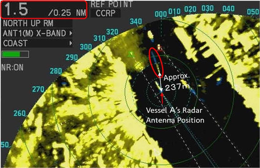
19:26:14 35-35-46.8 139-46-42.1 695 609
(3) Signs of Vessel B appeared at 19:07:37, approximately 1,330 m north of Vessel A's radar
antenna (see Figure 11), and after that, the distance between the two vessels gradually decreased.
At about 19:15:50, Vessel B was shown at 237 m to the port stern side of Vessel A's radar antenna
(see Figure 12), but from 19:16:14 to 19:25:00, signs of Vessel B were not visible. At about
19:26:14, the distance between the two vessels widened, and Vessel B was visible again at about
695 m to Vessel A's radar antenna's starboard stern side. (See Figure 13)
- 19 -Figure 11 Image from the Radar of Vessel A at 19:07:37
Figure 12 Image from the Radar of Vessel A at 19:15:50
Figure 13 Image from the Radar of Vessel A at 19:26:14
- 20 -(4) The track of Vessel A based on the AIS data and the estimated track of Vessel B are shown in
Figure 14.
Shibaura
Landing Stage
The Wharf
Figure 14 Vessel A's track and Vessel B's Estimated track
2.7.2 The Operation of Vessel A and Vessel B According to the SOLAS Monitor
According to the video recording of the SOLAS monitor8 installed at the Aomi Container Wharf, Vessel
B was navigating near the port stern of Vessel A at about 19:15. However, at about 19:20, she was sailing
8 "SOLAS Monitor" refers to the monitoring equipment installed for monitoring the waters within and in front of eminent
international terminal facilities, in accordance with the Ordinance for Enforcement of the Act for Securing Security of
International Navigation Ships and International Port Facility.
- 21 -near the port bow of Vessel A.
2.7.3 Relative Positions of Vessel A and Vessel B after 19:15:50
Table 4 shows the sailing distance of Vessel A and the estimated sailing distance of Vessel B at the
speed of approximately 8.5 kn based on the positions of Vessel A and Vessel B recorded on the AIS at
19:15:50, as well as the distance of Vessel B from Vessel A's bow. Figure 15 shows the relative positions
of Vessel A and Vessel B.
Table 4 Sailing Distance of Vessel A and Vessel B;
Distance of Vessel B from Vessel A's Bow from 19:15:50 onwards
Sailing Estimated The Distance of Vessel B
Time Distance of Sailing Distance from Vessel A's Bow (m) ※
Vessel A (m) of Vessel B (m)
19:15:50 0 0 -312
19:16:50 138 263 -187
19:17:50 317 527 -102
19:18:50 529 791 -50
19:19:50 756 1,050 -18
19:20:50 1,000 1,313 1
19:21:50 1,252 1,577 13
19:22:50 1,508 1,841 21
19:23:49 1,762 2,100 26
19:24:43 2,023 2,337 2
※ - (Minus) indicates the stern side of Vessel A
The distance from the bow of Vessel A to Vessel B is stated as the distance in the navigation
direction because the course of Vessel A and Vessel B were nearly identical.
Based on the distance and time from the position of Vessel B at 19:15:50 to the estimated
collision location, the estimated speed of Vessel B was determined to be approx. 8.5 kn.
- 22 -Figure 15 Relative Positions of Vessel A and Vessel B
2.8 Information about the Time of Collision between Vessel A and Vessel B
According to the statement of Master B, Vessel B collided with Vessel A near the port side of
Vessel A's bulbous bow, and after going over Vessel A's bulbous bow, and made contact with the shell
plating of Vessel A's starboard hull while maintaining her navigation. After Vessel A had passed,
Master B turned the engine to a neutral position, and at about 19:28, he confirmed the name and other
information about Vessel A on the AIS Vessel Information Application. (See Figure 16)
- 23 -Date and Time of the Photoshoot
6/10
19:28
Figure 16 AIS vessel Information Taken by Master B at 19:26
2.9 Information on Safety Management
2.9.1 Vessel A
(1) According to Company A2's Safety Management Manual, the preparations for departure were as
follows.
Ship Operation Procedure (Tentative translation of the excerpt)
Chapter 10 The inspection of Arrival / Departure in Port
10.1-10.3 Omitted
10.4 Work for Departure
1)-10) Omitted
11) Master confirms safty after departure, and dismisses the departure station and orders navigation
duty.
(The rest is omitted)
(2) The contents of the non-conformity report submitted by Master A to Company A2 after the accident
were as follows.
① Contents of N/C
Collision with small boat after departure TYO Shinagawa Wharf 2019.06.10 1900LT during
sailing near Oi container Wharf.
② Cause Analysis of N/C
- 24 -a. Human Causes: Did not sharp lookout during departure.
b. Technical causes: Radar had very poor image due to heavy rain.
③ Preventive Action
Keep well watch & using radar carefully
2.9.2 Vessel B
According to the statement of Master B, it was as follows.
Company B distributed a copy of the "Navigational Safety Instruction Manual for Construction Vessels
in Tokyo Port (2nd Edition)," issued on March 2018 by the Bureau of Port and Harbor, Tokyo
Metropolitan Government, to Vessel B and advised her on safe navigation regarding precautions for
large vessels.
Chapter 4 Points of Attention for Navigation and Maneuvering in Tokyo Port
1 Notes on the Difference in Vessel Size
Large vessels, such as container vessels, have the following characteristics, and therefore, navigation
should be carried out with these in mind.
①~③ Omitted
④ Large vessels have a large blind spot in their bow direction, and small vessels within the blind
spot cannot be seen from the large vessels.
In particular, large vessels are not able to see small vessels from the bridge area that is not visible
from small vessels (blind spot), so a smooth evasive maneuver is required to avoid entering this blind
spot.
(The rest is omitted)
In accordance with Article 189 of the Act on Port Regulations, Master B was trying to navigate away
from large vessels with a poor and limited scope of maneuverability, so as not to interfere with their
navigation.
2.10 Investigations of the paint coating peelings scattered on Vessel B
The results of the identification test using infrared spectroscopy10 entrusted to ANALYSIS CENTER
9 Article 18, clause 1 of the Act on Port Regulations states that "In a port, Miscellaneous Vessels shall keep out of the way of
vessels other than Miscellaneous Vessels." Moreover, "Miscellaneous Vessels" refer to steam launches (refer to steamships
with less than 20 tons of gross tonnages), barges, boats, and other ships operated solely by oars and paddles or those operated
mainly by oars and paddles (Article 3 of Port Regulations Act). Furthermore, Article 3 and Article 8 were amended on
November 1, 2016. The "Miscellaneous Vessels" on Article 3 was amended to "Miscellaneous Vessels (Steam Launches etc.)",
and "steam launches" was amended to "steam launches (refer to steamships with less than 20 tons of gross tonnages)".
10 Infrared spectroscopy is an analytical technique that utilizes the characteristics of substances (mainly organic substances) in
absorbing infrared light. Infrared absorption varies with the type of functional groups (atomic groups) that make up the matter,
so the results obtained by this measurement result (IR spectra) are specific to the components of the substance. Therefore,
information about material constituents can be obtained by analyzing the IR spectra. Also, by comparing the IR spectra of
- 25 -CO., LTD. were as follows.
As shown in Figure 17, the wavenumber region and the infrared absorption seen in the IR spectra of the
"Fallen Objects on Vessel B" match well with the "Paint Coating of Vessel A". From this, it was concluded
that "Fallen Objects on Vessel B" and "Paint Coating of Vessel A" are of the same component.
Therefore, it was probable that the "Fallen Objects on Vessel B" was derived from the "Paint Coating of
Vessel A".
(1) The Appearance of "Fallen Objects (2) The Appearance of "Paint Coating
on Vessel B" of Vessel A"
(3) IR Spectrum Comparison of "Fallen Objects on Vessel B" and "Paint Coating of Vessel A"
Figure 17 Result of an identification test using infrared spectroscopy (Excerpt)
each material, it is possible to investigate whether they are the same or different components.
- 26 -3 ANALYSIS
3.1 Situation of the Accident Occurrence
3.1.1 Evidence of the Accident Occurrence
According to 2.10, from the result of the component analysis, the blue paint fragments scattered on the
deck of Vessel B were identical to the paint coating on the hull of Vessel A, so it is highly probable that
they were peeled off and fell from Vessel A when the vessels came in contact at the time of the accident.
3.1.2 Course of the Events
According to 2.1, 2.7, and 2.8 above, it is highly probable that the following events listed in (1) occurred
for Vessel A, and it is probable that (2) occurred for Vessel B.
(1) Vessel A
① At about 19:00 on June 10, after moving astern away from the Wharf toward Nagoya Port,
Vessel A turned to port and departed in the southeast direction on slow ahead.
② At around 19:07, Vessel A dismissed the crew members from their departure station.
③ At about 19:15, Vessel A set her course on 145° at approximately 4.0 kn off the Oi Container
Wharf and began proceeding southeast. After that, when she gradually increased her speed as
she proceeded toward Tokyo West Passage, her port bow collided with Vessel B, and after that
her starboard bow made contact with Vessel B.
(2) Vessel B
① At around 19:05 on June 10, Vessel B departed the Shibaura Landing Stage at Tokyo Section
2 in Keihin Port and began navigating at half ahead.
② At around 19:07, in the vicinity of the northeast end of the Wharf, Captain B turned Vessel B
to starboard and set her course to the offshore of Haneda Airport. Vessel B then headed toward
Daikoku Wharf at Yokohama Section in Keihin Port with the main engine on full ahead at a
speed of just under 9 kn.
③ While navigating on the offshore of Oi Container Wharf from the offshore of the Wharf, Vessel
B advanced from the aft to the fore near Vessel A's port side and proceeded southeast on a
course that intersected with Vessel A's course.
④ After Vessel B collided with the port bow of Vessel A, which was catching up with an
increasing speed, Master B took hard starboard and increased her speed, causing her to go over
Vessel A's bulbous bow and went around to the starboard side.
⑤ According to the GPS position information and the radar video recording which took into
account the distance of approximately 75 m from Vessel A's radar antenna position to her bow,
the time when Vessel B went over Vessel A's bulbous bow from the port side was between
- 27 -19:24:43 and 19:25:04 (See Figure 18)
The position of Vessel B at
19:26:14 (After the collision)
Figure 18 Estimated Location of the Collision
3.1.3 Situation of the Collision
According to 2.1, 2.8, and 3.1.1, it is probable that Vessel A had a bow bearing of about 145° and a
speed of approximately 10.5 kn when she collided with Vessel B, which was proceeding southeast with a
speed of approximately 8.5 kn.
3.1.4 Date, Time, and Location of the Accident Occurrence
According to 2.7, 2.8, and 3.1.1, it is probable that the accident occurred at around 19:25 on June 10,
2019, and the location of the accident was about 347° true bearing, 950 m from the Tokyo West Breakwater
Lighthouse.
3.1.5 Damage to Vessels
According to 2.3, the damages to Vessel A and Vessel B were as follows.
(1) Vessel A
Abrasions with paint coating peelings on the port and starboard bow's shell plating.
(2) Vessel B
① Fractures on the mast.
② Breakages of the starboard light.
- 28 -③ Deformation of the wheelhouse.
④ Dents on the handrail of the starboard stern.
⑤ Damages on the propellers.
3.1.6 Casualties
According to 2.2, there were no casualties on both Vessel A and Vessel B,
3.2 Causal Factors of the Accident
3.2.1 Situation of Crew Members
According to 2.4, it is probable that the situation was as follows.
(1) Master A, Officer A1, and Officer A2
All of them possessed a legally valid certificate of competence.
It is probable that every one of them was in good health at the time of the accident.
(2) Master B
Master B had a legally valid certificate of competence.
It is probable that he was in good health at the time of the accident.
3.2.2 Condition of the Vessels
According to 2.5.3, it is probable that at the time of the accident, Vessel A and Vessel B had no
malfunctions or failures in their hulls, engines, and other types of equipment.
3.2.3 Weather and Sea Conditions
According to 2.6, it is probable that the weather at the time of the accident was rainy and the wind was
blowing northeast with a wind force of 4. Although it was during twilight within an hour after sunset, the
surrounding area was dark due to heavy rain, and the tidal current was flowing northwest at the speed of
about 1.0 kn.
3.2.4 Condition of the Navigation of Vessel A and Vessel B
According to 2.5.5, 2.7, and 2.8, it is probable that the situation was as follows.
(1) At around 19:15:50, Vessel B was navigating approximately 151 m behind the stern of Vessel A.
(2) At around 19:20:50, Vessel B was navigating near the bow of Vessel A.
(3) At around 19:23:49, Vessel B was navigating approximately 26 m ahead of the bow of Vessel A.
(4) At around 19:23:43, Vessel A increased her speed to about the same speed as Vessel B (8.6 kn) and
after that further increased her speed and caught up with Vessel B at around 19:25.
(5) At the time of the accident, Vessel B was unaware of Vessel A's presence and was navigating in
- 29 -the blind spot from inside the wheelhouse of Vessel A.
3.2.5 Analysis of Navigational Watch and Lookout
According to 2.1, 2.5.3, and 2.5.4, it is probable that the situation was as follows.
(1) Vessel A
① When the departure stations were effective, inside the wheelhouse of Vessel A, Master A was
guiding the maneuver while keeping a lookout on radar no.1, Officer A2 and the quartermaster
were in charge of the engine telegraph operation and the steering, respectively. At the bow,
Officer A1 was guiding the lookout and undocking duties while the boatswain and an ordinary
seaman were performing their respective tasks. At the stern, Officer A3 was guiding the lookout
and undocking duties while two ordinary seamen were working on their respective tasks.
② Master A dismissed the crew members from their departure station before "checking the
safety" as required by Company A2's Safety Management Manual for Vessel Navigation
Procedures.
③ Inside the wheelhouse of Vessel A after crew members were dismissed from their departure
station, Master A was guiding the maneuver while keeping the lookout on radar no.1, Officer
A2 communicated with Tokyo Port Radio on the VHF radio phone and operated the engine
telegraph while keeping the lookout, and Officer A1 was conducting lookout. However, no one
noticed the presence of Vessel B because the signs of Vessel B were hidden by reflection of rain
clouds and Vessel B was navigating within the minimum detection distance of Vessel A's radar.
(2) Vessel B
① For a thorough observation of his surroundings, from the time of departure, Master B been
maneuvering the vessel under conditions that made it difficult for him to assess the situation of
the surroundings: he was wiping his rain-soaked face with a towel with his head protruded
through the opening in the ceiling of the wheelhouse as he conducted the lookout. However,
when he navigated southeast within the Oi Container Wharf, he began to maneuver while sitting
on a chair.
② From the time Master B first recognized Vessel A until both ships were navigating parallel to
each other, Master B did not continue to monitor Vessel A's movements because he assumed
Vessel A was an incoming vessel and Vessel B had passed to the east of Vessel A, which was
mooring at the Wharf. Moreover, when Vessel A was navigating near Vessel B's starboard side,
Vessel B's starboard side's view was covered by the port hull of Vessel A, so she was unaware
that Vessel A was approaching.
③ After feeling the impact on her stern, the hull of Vessel B tilted sharply to starboard, and
Master B could see the bow of Vessel A through the starboard window.
- 30 -3.2.6 Analysis of the Radar Images of Vessel A
According to 2.5.3 and 2.7, it is probable that the situation was as follows.
(1) Between 19:10:14 and 19:14:50, Vessel B's signs were hidden by reflections of rain clouds.
(2) At about 19:11:14, the FTC adjustment was set to 10 in order to reduce the effects of the rainfall.
(3) Vessel A's minimum detection distance was about 0.1 M (approx. 185 meters), and the signs of
Vessel B did not appear in the radar image after 19:15:50.
(4) After 19:20:26, due to the effect of increasing the FTC adjustment from 10 to 14 and then further
to 15 to reduce the effects of rainfall, the signs of Vessel B only reappeared after 19:26:14, at a
distance of more than 695 meters from radar no.1's antenna. (See Figure 19)
Figure19 Information on Vessel B based on the Recorded Images from the VDR of Vessel A
3.2.7 Analysis of the Bridge Visibility of Vessel A
From 2.5.5, 2.7.3, and 3.2.6, it is probable that until around 19:17, Vessel B was navigating more than
17 meters away from Vessel A's port side, which did not fall under the blind spot from the center of Vessel
A's wheelhouse. However, from around 19:18, Vessel B navigated closer to within 17 meters of the port
side of Vessel A and entered the blind spot from inside Vessel A's wheelhouse. (See Figure 20)
- 31 -Figure 20 Blind Spot inside the Wheelhouse of Vessel A
and the Navigational Track of Vessel B
3.2.8 Analysis of the Accident Occurrence
According to 2.1, 2.3, 2.7, 2.8, 3.2.6, and 3.2.7, the situation was as follows.
(1) Vessel A
① It is highly probable that Vessel A assigned her crew members to departure duties, and at
around 19:00, after proceeding astern away from the Wharf, she turned to port and navigated
toward the Tokyo West Passage.
② It is probable that at around 19:07 after Master A dismissed the crew members from their
departure station, no crew member in the weather deck performed the lookout so nobody noticed
Vessel B's presence.
③ It is highly probable that from 19:10:14 to 19:14:50 Master A and Officer A1 could not
recognize Vessel B on the radar because she was hidden by reflections of rainclouds, therefore
they did not notice Vessel B was approaching.
④ It is highly probable that after 19:16:38, Master A and Officer A1 were not able to recognize
the signs of Vessel B because she was navigating within the minimum detection distance of radar
no.1.
⑤ It is highly probable at around 19:18, Master A and Officer A1 did not recognize Vessel B
because she had entered the blind spot from the wheelhouse, so Vessel A proceeded southeast
without realizing her collision with Vessel B.
⑥ It is highly probable that when Vessel A was navigating at an increasing speed, the Japan
Coast Guard contacted and informed her about her collision with Vessel B.
⑦ It is probable that the fact that Vessel A was not keeping a lookout from the wing to
compensate for the blind spot and the area within the minimum detection distance has possibly
contributed to the occurrence of this accident.
(2) Vessel B
① It is probable that at around 19:05, Vessel B had departed Shibaura Landing Stage at Tokyo
- 32 -Section 2 in Keihin Port and started to navigate at half ahead.
② It is probable that at around 19:07 in the northeastern end of the Wharf, Master B first
recognized Vessel A and thought that she was an incoming vessel as she appeared to be
stationary.
③ It is probable that Master B did not confirm Vessel A's movements because he thought
Vessel A was mooring at the Wharf, so he set Vessel B's course to the offshore of Haneda
Airport and proceeded at full ahead.
④ It is probable that in the vicinity of the Wharf, Master B thought that on her starboard side,
Vessel B had passed the mooring Vessel A. He did not realize that Vessel A was increasing her
speed and approaching Vessel B's starboard side, so he continued navigating until Vessel B
approached Vessel A's bow near the Oi Container Wharf.
⑤ It is probable that the fact that Master B did not notice Vessel A approaching might have
been contributed by the noise of Vessel B's main engine and the sound of rainfall at the time of
the accident.
4 PROBABLE CAUSES
It is probable that the accident occurred when Vessel A and Vessel B were both proceeding southeast,
Vessel A approached from the stern, gradually sped up, and continued to navigate parallel without noticing
Vessel B navigating near her bow at twilight after sunset in Tokyo Section 3 at Tokyo Port under the condition
whereby it became dark and difficult to see in the surroundings due to heavy rain. It is probable that both
vessels collided because Vessel B also continued navigating at a constant speed without noticing that Vessel
A was proceeding southeast after she departed.
It is probable that Vessel A continued her navigation without noticing Vessel B because the surroundings
were dark and the visibility was poor due to the influence of heavy rain. On top of that, Vessel B was a small
vessel approaching Vessel A from her stern, and after she navigated within the minimum detection distance
of Vessel A's radar, she navigated inside the blind spot from Vessel A's wheelhouse.
It is probable that the fact that Vessel A dismissed her crew members from departure stations and began
proceeding southeast under the condition of poor visibility due to the influence of heavy rain, might have
contributed to Vessel A not being able to notice Vessel B.
It is probable that the reason why Master B did not monitor Vessel A's movements and continued with the
navigation was, from the first time he noticed Vessel A, he assumed that she was an incoming vessel mooring
at the Wharf.
It is probable that the noise from Vessel B's main engine and the sound of rainfall at the time of the accident
might have caused Master B not to notice that Vessel A was approaching.
- 33 -5 SAFETY ACTIONS
It is probable that Vessel A and Vessel B were proceeding southeast and did not notice that they were
approaching each other before colliding during the twilight after sunset when it was dark and difficult to see
the surroundings due to the influence of heavy rain.
It is probable that this accident could have been avoided if Vessel A had noticed Vessel B's presence before
she goes into Vessel A's blind spot by compensating for the blind spot inside the wheelhouse by conducting
a lookout from the wing. Moreover, Vessel B could have monitored Vessel A's movements more carefully
and navigated without approaching Vessel A.
Therefore, it is necessary to implement the following measures to prevent the recurrence of similar
accidents.
(1) Masters of large vessels should remind himself that radars cannot detect vessels that are within the
minimum detection distance and reinforce the visibility lookout but crew members stationed on the
deck in order to watch for small vessels approaching suddenly, especially when proceeding astern and
at a low speed as they enter or leave the port. Furthermore, the crew members should be dismissed
from their respective departure station at an appropriate time after confirming the safety of the
surroundings.
(2) Masters of large vessels should conduct a lookout not only from inside the wheelhouse but also from
the wing to check the presence of vessels navigating within the radar's minimum detection distance
and inside the blind spot of the wheelhouse.
(3) Before departure, masters of miscellaneous vessels should obtain information on the movements of
vessels entering and leaving port, conduct sufficient lookout of the surroundings, and navigate at a
distance sufficient enough not to interfere with the navigation of large vessels.
5.1 Safety Actions Taken
5.1.1 Safety Actions Taken by Company A2 and Vessel A
After this accident, as a safety measure to prevent the recurrence of similar accidents, the following steps
were taken by Company A2.
(1) Issued warnings to prevent the recurrence of similar accidents and provided non-conforming
information about this accident to vessels under their management.
(2) Make sure that the crew members know that they should remain on their departure station when
departing the Wharf until they reach the vicinity of the Oi Container Wharf.
5.1.2 Safety Actions Taken by Vessel B
- 34 -Company B shared the information on the sequence of events, conditions, and causes of the accident
with the crew members employed by Company B. Moreover, Company B also retrained their crew
members regarding the safe navigation precautions for large vessel navigation based on the "Navigational
Safety Instruction Manual for Construction Vessels in Tokyo Port (3rd Edition)" published by the Bureau
of Port and Harbor, Tokyo Metropolitan Government. Furthermore, in accordance with Article 18 of the
Act on Port Regulations, they were instructed to navigate far enough from large vessels while navigating
within the port.
5.2 Safety Actions Required
It is probable that the followings are useful in preventing the recurrence of similar accidents in the future.
(1) Miscellaneous vessels are to collect information on the movements of other vessels before they
undock and while they are navigating.
(2) In order to be able to recognize the movements of large vessels accurately and to be recognized
while miscellaneous vessels are navigating within the minimum detection distance of large vessels,
installation and promoting the use of AIS (including Simplified AIS11) on miscellaneous vessels are
desirable.
In order to contribute to the prevention of the recurrence of similar accidents based on the investigation
results of this accident, requests the cooperation of the Japan Distributor Association, Tokyo Barge
Transporters Cooperative Business Association, Yokohama Barge Transporter Cooperative Business
Association in disseminating this report to the parties concerned.
11 “Simplified AIS” refers to an AIS device that has smaller output than the AIS (Automatic Identification System) required in
specified vessels under international conventions and which can only send and receive information pertaining to the vessel's
name, position, speed, course, and vessel type.
- 35 -You can also read