MEDITERRANEAN AND BLACK SEAS HYDROGRAPHIC COMMISSION - XXII CONFERENCE REPORT BY CROATIA
←
→
Page content transcription
If your browser does not render page correctly, please read the page content below
MEDITERRANEAN AND BLACK SEAS
  HYDROGRAPHIC COMMISSION

     XXII CONFERENCE

       REPORT BY CROATIA

           27 - 28 May 2021
              VTC Event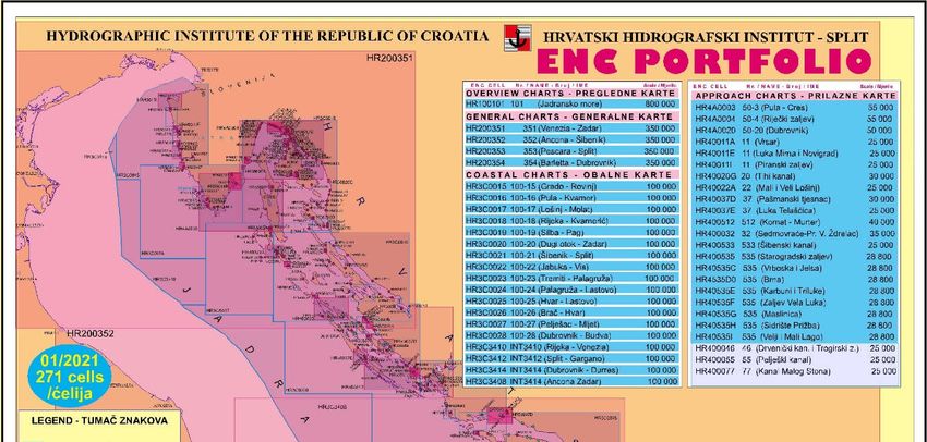
HYDROGRAPHIC INSTITUTE
                       OF THE REPUBLIC OF CROATIA

       MEDITERRANEAN AND BLACK SEAS
         HYDROGRAPHIC COMMISSION

                          XXII CONFERENCE

                              REPORT BY CROATIA

Prepared by:                                                                 CHI Director:
Assistant Director
Capt. Željko Bradarić, M.Sc.                                                 Vinka Kolić, M.Sc.

                          HR 21000 SPLIT, ZRINSKO-FRANKOPANSKA 161
     Phone: +385/21-308-800, Director +385/21-308-801 Telefax: +385/21-347-242; e-mail: office@hhi.hr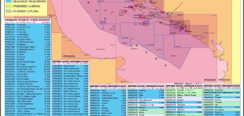
1.  CROATIAN HYDROGRAPHIC SERVICE ......................................................................1
    Legal framework .....................................................................................................................1
    CHI structure and main tasks of departments .........................................................................1
2. HYDROGRAPHIC SURVEY ..............................................................................................2
    Hydrographic Survey Vessels .................................................................................................2
    Status of hydrographic survey ................................................................................................3
3. CHARTS .................................................................................................................................3
    ENCs .......................................................................................................................................3
    ENC distribution method ........................................................................................................3
    WMS for ENCs .......................................................................................................................4
    INT ENC scheme ....................................................................................................................4
    RNCs .......................................................................................................................................4
    INT paper charts .....................................................................................................................4
    National paper charts ..............................................................................................................5
    New technologies ....................................................................................................................9
    Problems encountered .............................................................................................................9
4. NAUTICAL PUBLICATIONS ...........................................................................................10
    National official nautical publications series ........................................................................10
    Nautical publications issue ...................................................................................................10
5. MARITIME SAFETY INFORMATION (MSI) ...............................................................11
6. C-55 IHO PUBLICATION .................................................................................................12
7. CAPACITY BUILDING .....................................................................................................13
    New technologies ..................................................................................................................13
    Training .................................................................................................................................19
    ISO Quality Management System ........................................................................................20
    Bilateral and Multilateral Cooperation .................................................................................21
    EU projects............................................................................................................................24
8. OCEANOGRAPHIC ACTIVITIES...................................................................................27
    Cooperation and contribution to Permanent Service for Mean Sea Level (PSMSL) ...........27
    Oceanographic publications ..................................................................................................28
9. OTHER PROJECTS AND ACTIVITIES .........................................................................29
    National Marine Spatial Data Infrastructure – MSDI ...........................................................29
    Supporting marine policies for efficient protection, use and disaster management .............29
10. CONCLUSIONS ..................................................................................................................30
    Operational Level - status .....................................................................................................30
    Operational Level – challenges .............................................................................................30
    Management Level – challenges...........................................................................................31
    Expectations – topics for discussion and exchange of views and experiences .....................32
ANNEX 1 - CHI position in the structure of Croatian administration ..................................33
ANNEX 2 - Status of hydrographic survey in accordance with the IHO C-55 criteria ........34
ANNEX 3 - New hydrographic survey and ENC of marinas, small ports, shoals,
            underwater rocks, and installations ......................................................................35
ANNEX 4 - ENC 5-year priority plan based on new hydrographic survey - Overall ...........38
ANNEX 5 - ENC 5-year priority plan based on new hydrographic survey – Regional ........39
ANNEX 6 - Current ENC release status ....................................................................................41
ANNEX 7 - MEDINTCHART Catalogue - HR Status - Table................................................42
ANNEX 8 - MEDINTCHART Catalogue - HR Status – Figure .............................................43
ANNEX 9 - INT Paper Charts - HR Status – IHO INToGIS manager ..................................44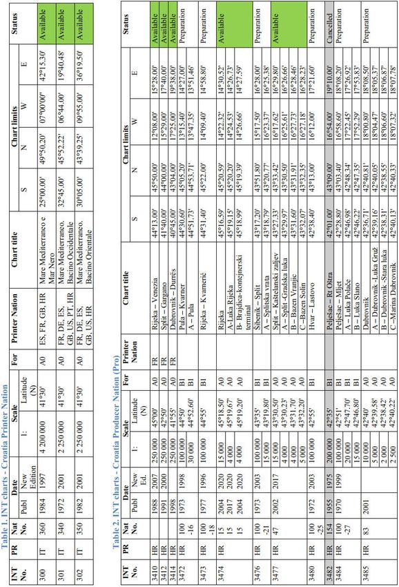
XXII MBSHC Conference                                                            Report by Croatia
27-28 May 2021, VTC Event

1. CROATIAN HYDROGRAPHIC SERVICE

Legal framework

In accordance with the provisions of SOLAS Chapter V (Hydrographic Service), that are
implemented in the Croatian national legislation (Hydrographic Activity Act, 1998, 2003, 2014),
Hydrographic Institute of the Republic of Croatia (CHI) carries out scientific and research work, as
well as development and professional tasks relating to the safety of navigation, hydrographic-
geodetic survey in the area of the national responsibility, marine geodesy, construction and
production of charts and nautical publications, oceanographic research, submarine geology
research, and finally publishing and printing activities. CHI is appointed National Coordinator for
navigational warnings. Position of the CHI in the structure of Croatian (maritime) administration is
shown in Annex 1. CHI is registered as a public institution of the Republic of Croatia in
accordance with the Law on Public Institutions. For details see www.hhi.hr.

CHI structure and main tasks of departments

Organisational structure of the CHI is arranged into several departments. Hydrographic activities
and data flow starts with the survey of the sea, in the internal sea waters, territorial sea and the
Ecological and Fisheries Protection Zone (ZERP) of the Republic of Croatia, covering a total
surface area of about 55,349 km² or 97.9 % of the Croatian land area (Fig. 1).

                            Figure 1. Data flow and working processes

Survey operations are carried out mostly by Hydrographic Department and Oceanographic
Department, with the support of s/v Hidra and s/v Palagruža. All measured data are stored into
databases with the support of Information System Department. Cartographic Department (Fig. 2)
and Nautical Department are responsible for the production and maintenance of official nautical
charts (paper and electronic ones), and other publications. The Notice to Mariners is issued on
monthly basis for the paper edition and weekly for the ENCs. Nautical Department as National
Coordinator for Navigational Warnings monitors and complies daily all the navigational warnings
important for the safety at sea. Reproduction Department is responsible for publishing and printing
of paper charts and publications.

                                                                                               1
XXII MBSHC Conference                                                           Report by Croatia
27-28 May 2021, VTC Event

           Figure 2. Structure in Cartographic department through various work process

2. HYDROGRAPHIC SURVEY

Hydrographic Survey Vessels

CHI has two survey vessels designed for the conduct of hydrographic survey, oceanographic
measurements, marine geology research, magnetometric detection, and cartographic revision of the
coastal and insular sea areas in the Adriatic Sea.
Smaller survey vessel HIDRA (Fig. 3) is used for survey operations in the coastal and inshore
areas of the Croatian part of the Adriatic. Survey vessel PALAGRUŽA (Fig. 4), due to its size and
equipment capable of operation in severe weather conditions, is used for the survey in the open
sea. With an endurance of 25 days at sea, it is also capable of operating in the Mediterranean Sea.

            Figure 3. s/v Hidra                                  Figure 4. s/v Palagruža

                                                                                           2
XXII MBSHC Conference                                                                             Report by Croatia
27-28 May 2021, VTC Event

Status of hydrographic survey
Hydrographic surveys conducted along the Croatian coast since the XXI MBSHC Conference
were focused to selective parts of the coastal areas and to principal ports and passages in
accordance with defined priorities. Total surveyed area is 569 km2. A considerable contribution to
the increase in the number of bathymetric surveys and surveyed areas, especially smaller ports and
newly constructed facilities and underwater installations, was achieved by introducing authorized
bathymetric surveying legal entities into the official surveying system. By the end of 2020, six
legal entities with authorizations to perform hydrographic surveying activities were registered in
Croatia according to the new Ordinance (January 2019).
Annex 2 summarizes the status of hydrographic surveys in accordance with the criteria in the IHO
C-55 publication. Annex 3 shows new hydrographic survey of marinas, small ports, shoals, and
underwater rocks.

3. CHARTS
CHI produces official paper and electronic navigational charts (ENCs) covering the waters within
the national responsibility (https://www.hhi.hr/en/products-and-services/hhi-service-catalog).

ENCs
In the period between two conferences the CHI produced 64 ENC cells based on the existing paper
charts and new hydrographic survey.
As it was planned, the CHI achieved adequate coverage, availability, consistency, and quality of
ENCs by 1 July 2012. An ongoing project was launched in 2014 to resolve observed cross-border
inconsistencies between the ENCs of different usage bands and improve the existing ENCs. Status
of the CHI ENC production is shown in the following table:

                    1 July 2008          1 July 2013         1 May 2017          1 May 2019           01 May 2021
User   Navigation   No       Area       No        Area       No        Area     No       Area        No       Area
band   al purpose    of    coverage   of Cell   coverage   of Cell   coverage    of    coverage       of    coverage
                    Cell     (%)                  (%)                  (%)      Cell     (%)         Cell     (%)

 1     Overview     1       100%         1       100%        1        100%       1      100%          1          100%
 2      General     4       100%         4       100%        4        100%       4      100%          4          100%
 3      Coastal     15      100%        15       100%       15        100%      18      100%          18         100%
 4     Approach     9       72%         13       85%        14        88%       19      91%           21         91%
 5     Harbour      31      77%         37       84%        40        88%       44      91%           44         91%
 6     Berthing     20      74%         24       85%        50        95%       121     98%          183         99%
       TOTAL        80      87%         94       92%        124       96%       207     97%          271         99%

Annex 4 shows Croatian ENC 5-year ENC production priority plan based on new hydrographic
survey - Overall. Annex 5 shows ENC 5-year ENC production priority plan based on new
hydrographic survey – Regional. Annex 6 shows current ENC release status.

ENC distribution method
CHI distributes its ENCs through the PRIMAR RENC. The first Croatian ENCs were released in
February 2007.
By the Navy Agreement, since the end of 2016 Croatian ENCs have also been available on
Croatian Navy ships.

                                                                                                             3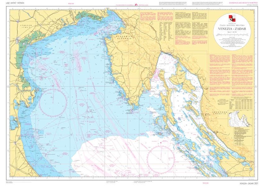
XXII MBSHC Conference                                                         Report by Croatia
27-28 May 2021, VTC Event

By the GMO Agreement through PRIMAR, since the March of 2021 Croatian ENCs have also
been available on CHI ship and for office ECDIS use.
In the period between the two MBSHC conferences, the CHI produced 64 new ENCs, 25 ENC
new editions, and 450 updates (ERs).

WMS for ENCs
CHI as a member of PRIMAR RENC actively participates in the project WMS for ENCs together
with other PRIMAR member states. At the moment, CHI and a few Croatian maritime
governmental organizations (MRCC, Maritime Directorate, HM Offices) and the Croatian Navy
use WMS for ENCs for administrative purposes (Fig. 5).

                              Figure 5. PRIMAR WMS for ENCs

INT ENC scheme
The current third draft proposal solution (ENC scheme for UB 1 and UB 2) for the Adriatic Sea
area, which is based on HR first proposal presented during the XVII MBSHC Conference, is still
under the process of harmonization between IT and HR, approaching the final solutions.
Some long-standing overlaps issue in UB3 between HR and IT is successfully solved through a
perfect coordination and cooperation between two hydrographic offices.
An intensive communication is underway between CHI and Montenegro HO to resolve an overlap
case in usage band 3.

RNCs
RNCs covering the Croatian area of responsibility are available from UK HO ARCS according to a
bilateral agreement.

INT paper charts
HR status of INT paper charts is shown in the table in Annex 7 and in the figure in Annex 8. CHI
made input of current INT Charts status (May 2021) using the IHO INToGIS manager (figure in
Annex 9).

                                                                                         4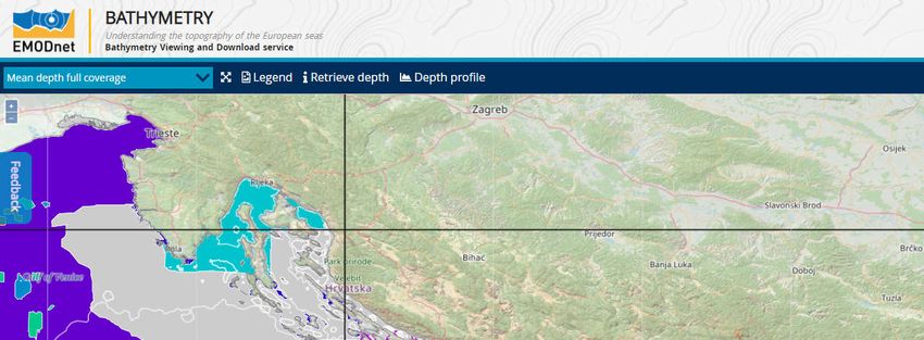
XXII MBSHC Conference                                                       Report by Croatia
27-28 May 2021, VTC Event

National paper charts
In the period between the two MBSHC Conferences the CHI published the following charts:

New charts Fig. 6, 7, 8, 9, 10:

                            Figure 6. 351 VENEZIA - ZADAR, 1:350 000

                            Figure 7. 352 ANCONA - ŠIBENIK, 1:350 000

                                                                                       5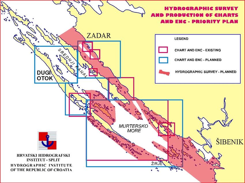
XXII MBSHC Conference                                                  Report by Croatia
27-28 May 2021, VTC Event

                            Figure 8. 353 SPLIT - PESCARA, 1:350 000

                      Figure 9. 354 BARLETTA - DUBROVNIK, 1:350 000

                                                                                  6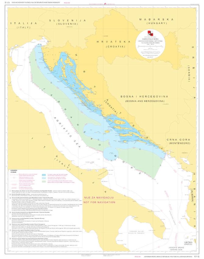
XXII MBSHC Conference                                                      Report by Croatia
27-28 May 2021, VTC Event

   Figure 10. 101G Granice RH na Jadranskom moru - Maritime boundaries of the Republic of
                  Croatia on the Adriatic Sea – in the final stage of preparation

                                                                                      7
XXII MBSHC Conference Report by Croatia
27-28 May 2021, VTC Event
New edition (Fig. 11,):
Figure 11. 15 (INT3474) Rijeka, 1:15 000,
Luka Rijeka, 1:4 000, Brajdica-kontejnerski terminal, 1:4 000
New printing
100-15 Grado – Rovinj 1:100 000
100-16 Pula – Kvarner 1.100 000
100-17 Lošinj – Molat 1:100 000
100-18 Rijeka – Kvarnerić 1:100 000
100-19 Silba - Pag 1:100 000
100-20 Dugi otok – Zadar 1:100 000
100-21 Šibenik – Split 1:100 000
63 Ploče 1:8 000
83 Dubrovnik 1:15 000
In addition to official nautical charts, 6 plans (harbour and port usage band) and 6 cells of the ENC
of some military ports. All these plans are plotted on the one paper chart (as confidential
nautical/naval chart.
8XXII MBSHC Conference Report by Croatia
27-28 May 2021, VTC Event
New technologies
The process of creating paper charts and ENC’s using the dKart cartographic software from the
Cartographic Database has been fully introduced.
Problems encountered
1. Some overlaps still exist between HR, IT and GR Overview and General ENCs. The process of
consideration of the final proposal is still underway between IT and HR.
2. A several small thin overlaps on IT/HR border in UB 3 are successfully solved through a
perfect coordination and cooperation between two hydrographic offices.
3. An overlap between HR and MNE ENC in UB 3 is under consideration according to the
preliminary technical arrangement.
4. Some inconsistencies observed between national (HR) paper charts and ENCs are under
constant consideration and deliberation. Furthermore, any feedback received from users, the
IHO or other hydrographic office is a matter of urgent examination and solving.
5. Problems of implementation of attributes SCAMIN has been recognized as a key task to be
realized in the ongoing period. Therefore, all information about the methodological approach to
the problem, organizational model and estimated time needed for implementation of attribute
SCAMIN on HR ENC are of particular importance and one of the objectives of the course.
Regarding the current paper chart-based scheming of the cells in UB3, CHI is planning for re-
scheming the cells in a square grid.
6. One of the challenges for the CHI will be transition to the new generation of ENC produced
according to S-101 standard. The issue is almost equally demanding in organisational,
technical-technological, and financial terms as the issue of transition from paper versions of
navigational charts to digital ones (ENC). The transition issue is additionally complicated by
the fact that it will be necessary to ensure maintenance and availability of both ENC
generations (Dual Fuel) for several years. Some initial tasks are dedicated to responsible staff
which close cooperates with PRIMAR and ECC staff through the several initiated and
approved S-100 projects. Training is recognized as a key element for realization transition from
S-57 to S-100 series product and services.
7. As regards navigation areas of non-SOLAS ships, particularly the areas of navigation and stay
of leisure boats and yachts a significant contribution towards improving the hydrographic-
navigational element of navigational safety was made through publishing of a considerable
number of new Croatian ENCs based on the data obtained from the new hydrographic survey.
Entire ENC folio has been made available to end users on ships and to maritime administration
worldwide through a network of authorised distributors by PRIMAR.
8. Most critical are those areas that have not been surveyed after interventions in the maritime
domain, and the relevant data has not been published in the CHI official editions. However,
according to the IHO specifications, even in these situations the relevant information ensuring
minimum requirements for safe navigation is available to users of CHI editions (descriptive
warnings of interventions in non-surveyed areas that have not been displayed on charts). In the
past two-year period, an improvement has been achieved even in these areas, because the
systematic hydrographic survey included a considerable number of marinas and small harbours
for which corresponding charts and ENCs were produced.
9XXII MBSHC Conference Report by Croatia
27-28 May 2021, VTC Event
4. NAUTICAL PUBLICATIONS
National official nautical publications series
Figure 12. CHI official nautical publications
Nautical publications issue
Since the XXI MBSHC Conference the following publications have been issued:
Adriatic Sea Pilot volume I and II 2020 (HR edition), 2021 (ENG edition)
Tide Tables:
- Tide Tables 2020
- Tide Tables 2021
Nautical Almanac:
- Nautical Almanac 2020
- Nautical Almanac 2021
- Nautical Almanac 2022 (in preparation)
List of Lights and Fog Signals 2020
Catalogue of Nautical Charts and Publications 2020/2021 (paper and digital editions)
Notices to Mariners (paper and digital monthly edition)
10XXII MBSHC Conference Report by Croatia
27-28 May 2021, VTC Event
5. MARITIME SAFETY INFORMATION (MSI)
In the Republic of Croatia MSI service (Navigational Warnings) is available 7/24/365. NAVTEX
broadcasts are transmitted in English and Croatian. MSI are transmitted regularly on VHF
channels of coastal radio stations.
Correctness of the promulgation of information is controlled on the NAVTEX receiver and VHF
station installed in the CHI Nautical Department (Fig. 13). There is no failure occurring during
ordinary operation.
Figure 13. Equipment for monitoring the correctness of the promulgation of navigation warnings
Schedule of navigational warnings is shown in the following table:
NAV. WARNINGS 2019 2020 2021
(Until 15.4.2021)
NAVAREA 1 10 1
COASTAL 91 106 61
TOTAL 519 417 142
11XXII MBSHC Conference Report by Croatia
27-28 May 2021, VTC Event
Navigational warnings are drafted according to IHO publication S-53 and there has been a high
degree of unification and standardization achieved when it comes to general principles applied to
message drafting. Hence, the CHI Nautical department continuously contributes to overall quality
and consistency of MSI messages.
Besides, the CHI Nautical department intensively cooperates with relevant factors in the maritime
domain such as: Harbour master offices, Coastal radio stations, Croatian VTS and MRCC,
Croatian Navy, ship-owners, private boaters, etc. The main goal is to ensure safety of navigation
by gathering the urgent safety information and issuing navigational warnings. Nevertheless, the
CHI Nautical department cooperates with NAVAREA III coordinator Cadiz through Coast radio
station Split, and there were no difficulties identified in overall communication.
In the past period, since the last MBSHC Conference, in addition to Croatian NAVTEX system
[Q] located on the island of Hvar to cover the area of the Croatian part of the Adriatic Sea,
NATIONAL NAVTEX 490 kHz SERVICE [F], fully operational since 24 April 2019 at 1250
UTC, when the first broadcast on 490 kHz was transmitted has become fully adopted keeping the
overall safety of navigation in the Adriatic Sea within the high standards.
6. C-55 IHO PUBLICATION
Updating information was provided on 30 May 2019. using a new IHO online submission
functionality (Fig.14).
Figure 14. IHO C-55 online submission updates
12XXII MBSHC Conference Report by Croatia
27-28 May 2021, VTC Event
7. CAPACITY BUILDING
New technologies
Computer and communication infrastructure
The implementation of a new server communication infrastructure is underway with the aim of
increasing availability and security. Client computers are migrating to the new infrastructure. The
energy infrastructure has been upgraded in the server room (Fig. 15).
Figure 15. New server communication infrastructure
Print on Demand printing technology has been introduced, using a large format plotter capable of
producing high-quality paper charts printed to order (Fig. 16). The introduction of the Print on
Demand process significantly reduces the quantity of nautical paper charts in the HHI warehouse.
This is an important shift, since all the printed charts are stored at the HHI warehouse, and over
time, after corrections made by NTM’s, it is necessary to update them before delivery by any of
these methods (machine automated correction, manual correction) for the customer to receive an
up-to-date nautical chart. After printing, the nautical paper chart shall be up to date with the last
NTM (Notice to Mariner).
Figure 16. Print on Demand
13XXII MBSHC Conference Report by Croatia
27-28 May 2021, VTC Event
WEB Services
The new CHI web pages were created (www.hhi.hr), providing a variety of new information and
services, with modern design and functionality (Fig. 17).
Figure 17. New CHI web pages
Online publication Catalogue of Nautical Charts and Publications is updated on a regular basis
(Fig. 18).
Figure 18. Online Catalogue of Nautical Charts and Publications
14XXII MBSHC Conference Report by Croatia
27-28 May 2021, VTC Event
E-Services of Notices to Mariners and Navigational Warnings are available on the CHI website.
Digital “Notices to Mariners” provide monthly updates for official editions, as well as archives of
previously published digital notices (Fig. 19).
Figure 19. Notices to Mariners e-Service
Radio Navigational Warnings Service was rose to a higher level. Navigational warnings are
updated promptly on the CHI web, as soon as new information is reported and promulgated to
mariners by ordinary means (NAVAREA, NAVTEX or VHF) (Fig. 20).
Figure 20. Navigational Warnings e-Service
15XXII MBSHC Conference Report by Croatia
27-28 May 2021, VTC Event
Oceanographic data acquisition system
Portal Operational Oceanography - Adriatic Sea online is available on the new Institute website
(http://adriaticsea.hhi.hr)
The traditional approach to oceanography is based on field research, and data collection from
remote coastal stations or during research cruises and then their post processing and comparison
with modelling results.
The importance of operational oceanography can be seen when studying climate change,
disturbances in the marine food chain, safety of navigation, protection against flooding or
protection against pollution. These are all problems that can occur in the Adriatic.
Having in mind all the above, HHI has developed its own specialized web application called Portal
Operational Oceanography - Adriatic Sea online. On this web page near real time measurement
from tide gauge stations in Rovinj, Zadar, Split, Ploče and Dubrovnik and waverider stations in the
Adriatic (Dubrovnik, Split and Rijeka) can be found. The application provides the ability to
download measured data from web page directly. Also, HHI intention is to establish new
measuring stations and further develop the application with new modules. This application also
shows the actual measurements of wind in Split and Ploče and air pressure in Split. The mentioned
portal (Fig. 21, 22, 23) is the first step towards operational oceanography.
Figure 21. Operational Oceanography Portal - Adriatic Sea online
16XXII MBSHC Conference Report by Croatia
27-28 May 2021, VTC Event
Figure 22. Tidal measurements and tide-gauge data e-Service
Figure 23. Wave measurements and tide-gauge data e-Service
17XXII MBSHC Conference Report by Croatia
27-28 May 2021, VTC Event
GIS
A GIS component of a functional prototype of the Hydrographic Information System is under
development. The determination and organization of spatial data from the area of competence of
the HHI is in progress (Fig. 24).
Figure 24. A prototype of the Hydrographic Information System
Croatian Marine Spatial Data Portal – GeoAdriatic (Fig. 25) provides search and view services for
marine spatial data, and e-services from the scope of the Hydrographic Institute of the Republic of
Croatia https://geoadriatic.hhi.hr/
Figure 25. Croatian Marine Spatial Data Portal - GeoAdriatic
18XXII MBSHC Conference Report by Croatia
27-28 May 2021, VTC Event
Online Library Catalogue
Special library software package METELwin is upgraded aiming to promote the resources of the
CHI Library, including several modules (cataloguing and classification, management of users’
records, statistics, search of library catalogue by all criteria) to cover most library operations. This
new software enables online access and search of library catalogue (Fig. 26).
Figure 26. METELWin Applicatio
Training
Participation in professional webinars and trainings
1. A total of 14 employees have registered to participate in a series of S-100-based online
training courses organized by PRIMAR for its Member States.
2. Participation in a one-day webinar organized by the Finnish company "Arctia Finland" on
"Bathymetric LiDAR as an effective method for coastal and shallow water bathymetric
mapping".
3. Participation in a one-day seminar organized by PRIMAR on the topic of training the
Central Administrator to administer the delivery of ENCs for the needs of HHI users (office
and ship ECDIS), in accordance with the concluded GMO agreement on the delivery of
ENCs.
4. Participation in a one-day webinar organized by PRIMAR on the topic of developing the
PRIMAR service for its members, which would provide a simpler service of providing S-57
data for reuse by third parties.
5. Participation in a one-day webinar organized by ESRI on "What's New in ArcGIS Maritime
with S-57 and Automation Confirmation"
6. One HHI employee (from the Cartographic Department) completed the training in the Arc
GIS PAGO software.
7. During 2020, due to the epidemiological situation (COVID-19), educations and trainings
were held by the webinars for:
- CARIS BASE Editor,
- Transition to S100
- Pink-to-chart: expectations and emerging technologies
8. Due to the pandemic Covid-19, planned trainings and educations for the Nautical
Cartographer Cat B were not achieved, and HHI plans to realise them for 2-3 cartographers
when opportunity arises.
19XXII MBSHC Conference Report by Croatia
27-28 May 2021, VTC Event
ISO Quality Management System
CHI successfully completed the process of ISO 9001:2015 certification (2020, 2021). An external
audit is performed on yearly basis aiming to improve and confirm the certificate and compliant the
CHI business process with ISO 9001:2015 standard. (Fig. 27).
Figure 27. Certificate of compliance with the ISO 9001:2015 standard
20XXII MBSHC Conference Report by Croatia
27-28 May 2021, VTC Event
Bilateral and Multilateral Cooperation
Bilateral agreements
Activities within the bilateral arrangement between Croatia and Italy are continued.
In accordance with the bilateral agreement in force between the UKHO and CHI, intensive
cooperation has been established and continued with the UKHO RT2 South Geographic Manager
to address and harmonize various data in official charts and publications of both hydrographic
offices.
Very good cooperation is taking place with the UKHO (IPS) under the Custodianship Agreement,
which defines the licensing process for making CHI data available to a third party, taking into
account principles of the public service data and information regulations.
Bilateral and multilateral meetings
CHI - UKHO licensing meeting
Working session with representatives of the UKHO Licensing Section was held in August 2020
and April 2021.
Main topics were related to numerous challenges coming from new requests for reuse of
hydrographic data. Certain legal, administrative, financial, organizational and ICT aspects of the
licensing issues were under comprehensive consideration.
CHI –IIM bilateral meeting
Two bilateral meeting were held (Croatia, Feb 2020 and Italy, July 2020). Main topics were related
to ENC overlap issue, bilateral agreement, and joint projects in the Adriatic Sea.
The IHO Council Meetings
CHI representatives were actively participated at 3rd the IHO Council meeting 2019 in Monaco and
4th Council meeting 2020 as VTC event.
The IHO Assembly
CHI representatives were actively participated at 2nd Session of the IHO Assembly 2020 as VTC
event.
PRIMAR Advisory Committee Meeting
CHI representatives were actively participated at 27th PRIMAR Advisory Committee meeting 2020
as VTC event after which Croatia took over a two-year chairships.
10th IHO WEND Working Group Meeting
Active participation in the two-day work (February 2021) of the IHO working group on "policy"
issues related to the transition to a new generation of ENCs based on the new framework standard
for hydrographic data S-100, (Fig. 28).
21XXII MBSHC Conference Report by Croatia
27-28 May 2021, VTC Event
.
Figure 28. Participants of the IHO WEND Working Group
International Conference on Satellite Bathimetry
Participation in the 3rd International Conference on Satellite-Derived Bathymetry "SDB Day
2021”, (Fig. 29).
Figure 29. SDB Day 2021
IHO CSB Working Group Meeting
Participation in the work of the IHO working group for the so-called Crowd-Sourced Bathymetry
(CSB) - correspondence and video meeting from 30 March to 1 April 2021 (Fig. 30).
Figure 30. Participants of CSB WG Meeting
22XXII MBSHC Conference Report by Croatia
27-28 May 2021, VTC Event
Meeting of the three PRIMAR working groups
Participation in the work of the working groups for strategy (PSWG), marketing (PMWG),
technology (TEWG) and finance (PFWG) - correspondence and video meeting May 2021.
CHART project for Alumni Seminar
In organization by the IHO under the auspices of the Nippon Foundation from 28 to 31 October
2019 in Singapore, the second order of the CHART project Alumni Seminar was held. The
seminar was attended one CHI participants among 42 students (out of a total of 65) from the first
CAT B course (2009) and until 2019 (total 10 training courses) gained the status of CAT B
nautical cartographer (Fig. 31). In three days of the seminar, there was discussion of the future
"Capacity Building" program, strategy, and development of the same, cooperation with Nippon
foundation and network cooperation of all participants in the future. Also, there was also
mentioned academic and administrative review of the CHART project, a modern approach to
maintaining the competence standards for CAT B hydrographer and CAT B nautical cartographer.
With this training, it is continued education of HHI employees which have been trained through
IHO and excellent cooperation between all Members.
Figure 31. Representatives of IHO, NIPPON Foundation,
UKHO trainers and 42 students from courses from 2009-2019
TEWG meeting of & S-101 Workshop in Stavanger.
In October 2019 in Stavanger (Norway), a 16th meeting of the PRIMAR TEWG was held.
Representatives of 12 countries and industry representatives participated (Fig. 32). The Croatian
hydrographic Institute was represented by two employees from the HHI Cartographic Department.
New services of the PRIMAR and the current state of implementation of S-101 projects were
presented at the meeting. There was discussion about the status of the ENC’s of the new Members,
cooperation between regional electronic navigation centres, new methods, and solutions for the
distribution of ENC’s, as well as the current S-102 services implementation status (CHS). Current
working groups (HSSC11, S-101 PT4, ENCWG) have also been presented. A workshop was held
about the new generation of ENC’s according to IHO Standard S-101. During the workshop,
participants met the challenges of S-101 technology through data conversion, structural and
attribute display and function of the geometry and topology of ENC’s, with a particular focus on
the safety and data protection of the S-101 systems. This workshop has continued the training and
education of HHI employees and quality cooperation with the PRIMAR, the regional coordination
centre, which ensures the availability of ENC’s to the end-users.
23XXII MBSHC Conference Report by Croatia
27-28 May 2021, VTC Event
Figure 32. TEWG meeting and the S-101 workshop in Stavanger
EU projects
1. The European Marine Observation and Data Network (EMODnet) project
The EMODnet initiative has been launched by the European Commission - DG MARE as part of
its Marine Knowledge 2020 strategy and is implemented in partnership with over a hundred
European organizations. Within the EMODnet, associated organizations are working together to
bring together various sea information from a variety of sources and resources to enable searching
and browsing to the wider public. A total of 41 organizations from 20 countries (18 EU Member
States), located along the European seas, are participating in the project. Most organizations
include marine research institutes (17) and national hydrographic offices (16), with the
involvement of other experts from different research and ICT fields.
CHI has been partnering in the project since May 2017. Croatia supplied part of the data
Bathymetry (Fig. 33) and Geology (Fig. 34) layers in accordance with the national regulations and
contributed to the administration of the project. More information about the project can be found at
the following link: www.emodnet.eu
For the project EMODnet Bathymetry HRSM2, were created DTM’s (Digital Terrain Model), SHP
files and CDI (Common Data Index) files. For the EMODnet Bathymetry - HRSM2 were created
107 CDI files for 4 DTM’s (during 2020).
24XXII MBSHC Conference Report by Croatia
27-28 May 2021, VTC Event
Figure 33. EMODnet Bathymetry 2017-2109 contribution https://portal.emodnet-bathymetry.eu
Seabed substrate map based on simplified Folk classification scheme (1954) with 7 classes
(https://www.emodnet-geology.eu/map-viewer/), (Fig 34.)
Figure 34. EMODnet - Seabed substrate map
25XXII MBSHC Conference Report by Croatia
27-28 May 2021, VTC Event
The EMODnet bathymetry project 2020-2022 is under way. CHI will contribute with bathymetry
data for the area of 2003 square km (Fig. 35).
Figure 35. CHI contribution to EMODnet Bathymetry project 2020-2022
2. “Improving the hydrographic service and increasing the availability of hydrographic data”
In the past two-year period, a comprehensive documentation was prepared for launching a new
project called “Improving the hydrographic service and increasing the availability of hydrographic
data” which will be financed from EU fonds. The main goal of the project is to improve the
hydrographic services in organizational, technical-technological, and functional terms as
permanent activities 24/7 of special interest to the Republic of Croatia, and thus improve the
hydrographic-navigation element of the information segment of navigation safety in accordance
with new requirements. Additional but not less important goal is to ensure availability of
hydrographic data, products, and services to a wider community of users in other segments of
human activities.
26XXII MBSHC Conference Report by Croatia
27-28 May 2021, VTC Event
8. OCEANOGRAPHIC ACTIVITIES
Cooperation and contribution to Permanent Service for Mean Sea Level (PSMSL)
Monthly mean of sea level data from five stations (Rovinj, Zadar, Split, Ploče, Dubrovnik) are sent
to Permanent Service for Mean Sea Level (PSMSL) https://psmsl.org/, responsible for the
collection, publication, analysis and interpretation of sea level data from the global network of tide
gauges, based in Liverpool at the National Oceanography Centre (NOC), United Kingdom.
HHI is in the process of expanding the tide gauge network. New tide gauges will be equiped with
radar sensors and meteorological stations.
“StVar-Adri Project”
Scientists from the Oceanology department of HIRC are part of the research team on the Strength
and Variability of the Adriatic Sea Level Extremes in Present and Future Climates (StVar-Adri)
Project, which is funded by Croatian Science Foundation. Whole research team consists form
scientists from the University of Split, Faculty of Science (PMFST), Hydrographic Institute of the
Republic of Croatia, PMFST University of Zagreb, Faculty of Science (PMF), Institute of
Oceanography and Fisheries (IOF) in Split and Institute of Ocean Sciences, Department of
Fisheries and Oceans (IOSFO, Canada), Shirshov Institute of Oceanology of Russian Academy of
Sciences (IORAS, Russia). The project StVar-Adri aim is to estimate contribution of selected
components of extreme sea levels to present-day and future-day floods. To accomplish this goal,
the focus of the project is on: (i) cataloguing the strongest known events; (ii) estimating
contribution of individual processes to extreme sea levels using statistical tools and numerical
modelling, (iii) linking extreme sea levels to atmospheric processes, and (iv) assessing future
strength and variability of extreme sea levels using outputs of Regional Climate Models (RCMs).
There are also more than 60 smaller projects (e.g., outfall preparation studies, electric cable
preparation studies...) in which oceanographic data were measured and analysed. As an example,
Fig. 36 shows the current sedimentology chart, prepared for the Peljar publications.
Figure 36. Sedimentology chart updated with data from a series of projects (version end 2016)
27XXII MBSHC Conference Report by Croatia
27-28 May 2021, VTC Event
Oceanographic publications
Annual publications "Tide Tables – Adriatic Sea, East Coast" (Fig. 37) are also available in a
digital format.
Figure 37. Tide Tables – Adriatic Sea, East Coast 2021
28XXII MBSHC Conference Report by Croatia
27-28 May 2021, VTC Event
9. OTHER PROJECTS AND ACTIVITIES
National Marine Spatial Data Infrastructure – MSDI
CHI actively participates in the long-term Croatian project at national level for the implementation
of national legislation relating to NSDI aiming to establish the MSDI (Fig. 38).
Figure 38. An overview concept of Croatian MSDI
In Croatia, Marine Spatial Data Infrastructure (MSDI) is a component of National Spatial Data
Infrastructure, so currently CHI provides metadata to the Croatian NSDI Geoportal that serves as a
starting point for accessing spatial data sources that are, according to the NSDI Act (Official
Gazette 56/2013), part of National Spatial Data Infrastructure (http://geoportal.nipp.hr/en).
In the future CHI plans to set up a conceptual framework for Croatian MSDI with other providers
of marine data and partners. That includes building of a MSDI reference model and evaluating
Metadata & Data geo-portal.
Others
CHI personnel participated in several international scientific and technical conferences presenting
hydrographic and oceanographic papers.
Supporting marine policies for efficient protection, use and disaster management
CHI continuously participates in multiple projects designated by the competent administrations
providing high quality support.
29XXII MBSHC Conference Report by Croatia
27-28 May 2021, VTC Event
10. CONCLUSIONS
Operational Level - status
In the past two-year period, the status of hydrographic-navigational element of the navigational
safety was at an optimal level.
Entire area of responsibility of the Republic of Croatia for the hydrographic-navigational safety of
vessels has been covered by relevant official editions of navigational charts and publications –
paper and digital ones. This particularly applies to navigation areas of SOLAS ships.
Navigational warning service is in good working order, efficiently cooperating with all
navigational safety entities in Croatia, its neighbouring countries and the NAVAREA III
Coordinator.
Paper editions of official navigational charts are updated through monthly editions of Notices to
Mariners, and ENCs through weekly updates.
Significant progress has been made towards pleasure and yacht users by issuing a new edition of
the Adriatic Sea Pilot, the first and second parts in Croatian and English. Most of the plans of
small ports and marinas from the paper edition were also issued as ENCs.
Realization of hydrographic surveying and charting was conducted according to defined priorities
and the planned schedule. A total of 569 square kilometres were surveyed by the multi-beam
system equipment.
A significant contribution towards improving the hydrographic-navigational element of
navigational safety was made through publishing of a considerable number of new Croatian
electronic navigational charts (ENC) based on the data obtained from the new hydrographic
survey. In the period between two conferences 64 new ENCs were released. Entire ENC folio has
been made available to end users on ships and to maritime administration worldwide through a
network of authorised distributors by PRIMAR.
Since the end of 2016 Croatian ENCs have been made available on the Croatian Navy vessels
through the Navy Agreement. Agreements have also been concluded with the Directorate for the
Safety of Navigation of the Ministry of Maritime Affairs and the Croatian Navy on ENC usage for
administrative-office purposes (WMS for ENCs). Ongoing support is provided to ensure the
provision of timely and quality ENC service.
Since the beginning of 2021 Croatian ENCs have been made available for the Croatian
hydrographic survey vessel as well as for the CHI ECDIS office use through GMO agreement
signed between PRIMAR and HHI.
Some long-standing overlaps issue in UB3 between HR and IT is successfully solved through a
perfect coordination and cooperation between two hydrographic offices. Cooperation continues
resolving the remaining overlaps in UB1 and UB2.
CHI has maintained a high level of technical and technological equipment by acquisition of several
important systems, devices, and equipment through EU funded projects. Existing software of the
basic production line is regularly updated.
Operational Level – challenges
There are some problems and challenges regarding HR ENCs. Some overlaps still exist between
HR, IT and GR in Overview and General ENCs. Currently, there is a commonly harmonized
proposal, most likely to be the final solution.
30XXII MBSHC Conference Report by Croatia
27-28 May 2021, VTC Event
Problems of implementation of attributes SCAMIN CHI recognized as a key task planned to be
realized in the ongoing period. Regarding the current paper chart-based scheming of the cells in
UB3, CHI is planning for re-scheming the cells in a square grid.
Some inconsistencies observed between national (HR) paper charts and ENCs are under constant
consideration and deliberation. Furthermore, any feedback received from users, RENCs or the IHO
is a matter of urgent examination and solving
In the past two-year period, a comprehensive documentation was prepared for launching a new
project called “Improving the hydrographic service and increasing the availability of hydrographic
data” which will be financed from EU fonds. The main goal of the project is to improve the
hydrographic services in organizational, technical-technological, and functional terms as
permanent activities 24/7 of special interest to the Republic of Croatia, and thus improve the
hydrographic-navigation element of the information segment of navigation safety in accordance
with new requirements. Additional but not less important goal is to ensure availability of
hydrographic data, products, and services to a wider community of users in other segments of
human activities (The MSDI development).
One of the challenges for the CHI will be transition to the new generation of ENC produced
according to S-101 standard. The issue is almost equally demanding in organisational, technical-
technological, and financial terms as the issue of transition from paper versions of navigational
charts to digital ones (ENC). The transition issue is additionally complicated by the fact that it will
be necessary to ensure maintenance and availability of both ENC generations (Dual Fuel) for
several years. Some initial tasks are dedicated to responsible staff which close cooperates with
PRIMAR and ECC staff through the several initiated and approved S-100 projects. Training is
recognized as a key element for realization of transition to the S-100 series product and services.
CHI continuously participates in multiple projects designated by the competent administrations
providing high quality support. The CHI personnel participated in several international scientific
and technical conferences presenting hydrographic and oceanographic papers.
Through participation in several bodies and working groups of the IHO and PRIMAR RENC, the
CHI continues its proactive role and contributes to realisation of objectives established by these
organizations.
Recognizing a wider use of hydrographic data, CHI constantly improves the established licensing
model, keeping in mind obligations arising from the public service information regulations.
Achievement of main strategic and programme objectives in the current and next planned periods
will be challenging in every respect because it is expected to proceed in very restrictive conditions
with additional requirements and tasks.
Management Level – challenges
A general assessment of overall CHI capacity determines an approach to achievement of objectives
which will be based on prioritization, well organized business processes and cooperation between
employees, as well as good cooperation with the Management Board and competent ministry.
The main challenges in the forthcoming period will be in connection of updating an existing digital
production line and internal organizational restructuring to establish a new business model in
accordance with ISO QMS, which will ensure a modern and high-quality hydrographic service.
It is well known that the key point and premise of a quality hydrographic service is to achieve and
maintain a high level of motivated and educated staff. Overwhelming fact is that new technologies
pose high demands on the required qualifications of employees. This will be a major challenge, as
well as the introduction of new technologies. Set IHO S-100 related courses developed and offered
31XXII MBSHC Conference Report by Croatia
27-28 May 2021, VTC Event
by PRIMAR will make a great contribution toward acceptance of the new knowledge and
competences of the CHI staff for fulfilment required goals in forthcoming transition period.
Expectations – topics for discussion and exchange of views and experiences
Finally, in preparation for previous XXI MBSHC Conference the CHI prepared a list of hot
hydrography related topic as they were recognized for CHI, the MBSHC region and wider. Given
that the topics are still considered relevant for a better understanding of the overall situation in the
Croatian Hydrographic Service with an emphasis on operational, management and political
aspects, and expecting that this could contribute to the success of the conference through lectures,
discussions and exchanges of views and experiences, below are listed again, and slightly updated.
1. Smooth technological transition – HO organizational structure
2. Legal framework for hydrographic service – national prospective, strategic, and
planning docs
3. Data centric approach – challenges of introducing and implementations
4. ISO QMS design, implementation and improving
5. Dual fuel ENC service operating – S-57 and S-101,
6. National ENC distribution options and challenges
7. ENC S-101 test data development - expectations
8. ENCs overlap in region – applications of the WEND principles (Technical Agreement)
9. Increasing the availability of hydrographic data
10. Data licensing policy
11. Commercial hydrographic survey – legal aspect and implications
12. LIDAR experience and praxis (coastline and shallow waters)
13. Satellite bathymetric data (accessibility and applications)
14. Crowdsourced bathymetry – position and national regulation (restrictions)
15. Science approach for HO
16. Non-SOLAS ENCs and market options for leisure users – regulations
17. Regional cooperation with neighbouring countries
18. Regional Hydrographic Commission operation (capacity building)
19. e-Office – administrative arrangement and daily management
20. Distance training and video conferencing callenges
32XXII MBSHC Conference Report by Croatia
27-28 May 2021, VTC Event
ANNEX 1 - CHI position in the structure of Croatian administration
33XXII MBSHC Conference Report by Croatia
27-28 May 2021, VTC Event
ANNEX 2 - Status of hydrographic survey in accordance with the IHO C-55 criteria
Never been
Adequate survey Resurvey required
systematically surveyed
A1 A2 B1 B2 C1 C2
Depth
(200m) (200m) (200m)
Percentage
47,35 4,85 36,41 13,11 16,24 82,04
(%)
Area
21.095,17 527,55 16.218,64 1.425,64 7.234,70 8.924,03
(sq. km)
34XXII MBSHC Conference Report by Croatia
27-28 May 2021, VTC Event
ANNEX 3 - New hydrographic survey and ENC of marinas, small ports, shoals, underwater
rocks, and installations
35XXII MBSHC Conference Report by Croatia
27-28 May 2021, VTC Event
36XXII MBSHC Conference Report by Croatia
27-28 May 2021, VTC Event
37XXII MBSHC Conference Report by Croatia
27-28 May 2021, VTC Event
ANNEX 4 - ENC 5-year priority plan based on new hydrographic survey - Overall
38XXII MBSHC Conference Report by Croatia
27-28 May 2021, VTC Event
ANNEX 5 - ENC 5-year priority plan based on new hydrographic survey – Regional
39XXII MBSHC Conference Report by Croatia
27-28 May 2021, VTC Event
40XXII MBSHC Conference Report by Croatia
27-28 May 2021, VTC Event
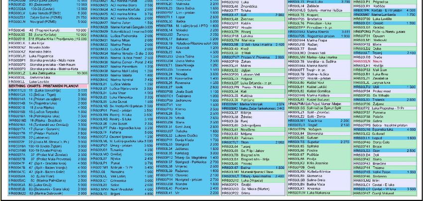
ANNEX 6 - Current ENC release status
41XXII MBSHC Conference Report by Croatia
27-28 May 2021, VTC Event
ANNEX 7 - MEDINTCHART Catalogue - HR Status - Table
42XXII MBSHC Conference Report by Croatia
27-28 May 2021, VTC Event
ANNEX 8 - MEDINTCHART Catalogue - HR Status – Figure
43XXII MBSHC Conference Report by Croatia
27-28 May 2021, VTC Event
ANNEX 9 - INT Paper Charts - HR Status – IHO INToGIS manager
44You can also read