Morphostructural Setting and Tectonic Evolution of the Central Part of the Sicilian Channel (Central Mediterranean)
←
→
Page content transcription
If your browser does not render page correctly, please read the page content below
GeoScienceWorld
                Lithosphere
                Volume 2021, Article ID 7866771, 24 pages
                https://doi.org/10.2113/2021/7866771

                Research Article
                Morphostructural Setting and Tectonic Evolution of the Central
                Part of the Sicilian Channel (Central Mediterranean)

                             Dario Civile , Giuliano Brancolini, Emanuele Lodolo , Edy Forlin , Flavio Accaino ,
                             Massimo Zecchin , and Giuseppe Brancatelli
                             Istituto Nazionale di Oceanografia e di Geofisica Sperimentale (OGS), Trieste, Italy

                             Correspondence should be addressed to Dario Civile; dcivile@inogs.it

                             Received 6 October 2020; Accepted 11 January 2021; Published 2 February 2021

                             Academic Editor: Andrea Billi

                             Copyright © 2021 Dario Civile et al. This is an open access article distributed under the Creative Commons Attribution License,
                             which permits unrestricted use, distribution, and reproduction in any medium, provided the original work is properly cited.

                             The Plio-Quaternary tectonic evolution of the central sector of the Sicilian Channel and the resulting morphostructural setting have
                             been analyzed using a large geophysical dataset consisting of multichannel seismic profiles, which some of them never published,
                             and available bathymetric data. This area hosts two regional-scale tectonic domains that registered the complex pattern of
                             deformation occurred since the Early Pliocene: (1) the Sicilian Channel Rift Zone (SCRZ), which can be divided into a western
                             sector formed by the Pantelleria graben (PG) and in a eastern one represented by the Linosa and Malta grabens (LG and MG)
                             and (2) the Capo Granitola-Sciacca Fault Zone (CGSFZ), a NNE-oriented lithospheric transfer zone that crosses the Sicilian
                             Channel from the Sicily coast to the Linosa Island, of which only its northern part has been studied to date. Data interpretation
                             has allowed achieving the following outcomes: (i) the presence of an alternation of basins and structural highs forming a NNE-
                             oriented separation belt between the western and eastern sectors of the SCRZ, and interpreted as the shallow expression of the
                             southern part of the CGSFZ; (ii) a NE-oriented tectonic lineament separating the MG in a northern and southern part, and
                             interpreted as the southern prosecution of the Scicli-Ragusa Fault System; (iii) the presence of syn-rift deposits in the Plio-
                             Quaternary fill of the grabens, suggesting that the opening of the grabens of the SCRZ was coeval, and started since Early
                             Pliocene in the framework of a NW-oriented right-lateral transtensional mega-shear zone; (iv) continental rifting ended around
                             the Early Calabrian, during which extensional tectonics dominated along the separation belt; (v) the CGSFZ conditioned the
                             SCRZ configuration at a regional scale, leading to the development of the PG in the western sector and of the LG and MG in the
                             eastern one; and (vi) after the Early Calabrian, the PG and the southern MG followed a different tectonic evolution with respect
                             to the LG and northern MG. The syn-rift deposits of the PG and southern MG were sealed by an undeformed post-rift
                             succession, while the LG and the northern MG suffered a basin inversion that ended around the Latest Calabrian time. During
                             this stage, the separation belt was affected by a transpressional tectonics. At present, the grabens of the Sicilian Channel seem to
                             be tectonically inactive, while the CGSFZ represents an active tectonic domain.

                1. Introduction                                                                              Zone (SCRZ) developed in the central part of the Sicilian
                                                                                                             Channel since Early Pliocene and consisting of three NW-
                The Sicilian Channel belongs to the North Africa continental                                 oriented deep tectonic grabens (Pantelleria, Linosa, and Malta;
                margin and hosts a foreland-foredeep-chain system consist-                                   PG, LG, and MG; Figure 1) [2–6] and (2) the Capo Granitola-
                ing of the offshore part of the Neogene-Quaternary Sicilian-                                  Sciacca Fault Zone (CGSFZ) [7], a NNE-oriented lithospheric
                Maghrebian chain, the Gela foredeep basin, and the Pelagian                                  transfer zone that crosses the Sicilian Channel for at least
                foreland (Figure 1). Despite foreland domains are relatively                                 200 km from the Linosa Island to the Sicily coast between
                stable areas affected by a weak deformation [1], the Pelagian                                 Capo Granitola and Sciacca Town (Figure 1) [4, 7–11].
                foreland includes two regional-scale tectonic domains: (1)                                       The central part of the Sicilian Channel, far from the
                the ~300 km long and 100 km wide Sicilian Channel Rift                                       coasts, remains as a large, mostly unexplored area on which,

Downloaded from http://pubs.geoscienceworld.org/gsa/lithosphere/article-pdf/2021/1/7866771/5226102/7866771.pdf
by guest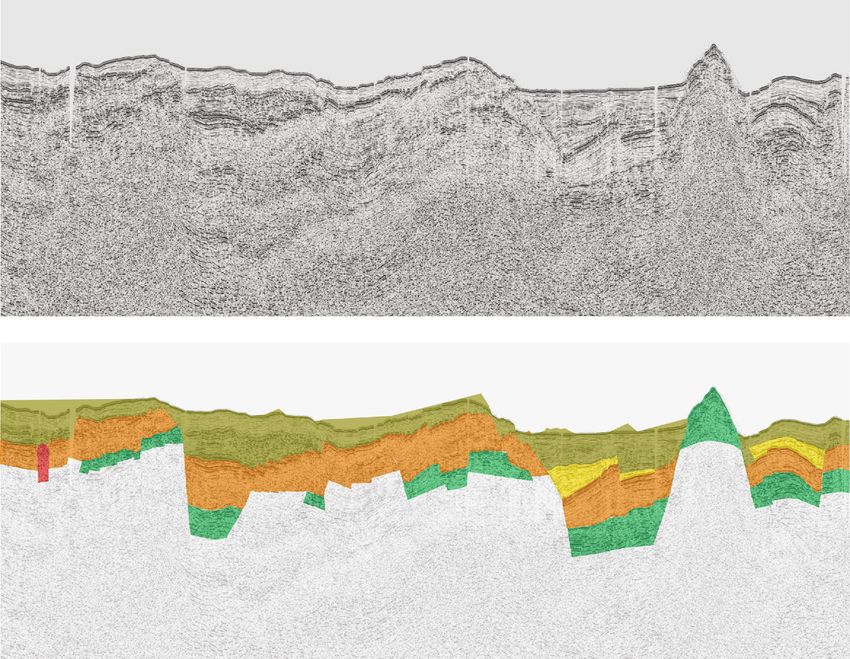
2 Lithosphere
Thrust AF
Strike-Slip Fault SA (b)
Normal Fault
Tyrrhenian
KCU
back-arc basin
Corsica-Sardinia (a)
Block
in rc
cha A
ian an
hreb bri
Mag SFTB EV a la
ian- C
Sicil
CGSFZ
GF HP
PI
PG
ETF
S
ME
F
SR
SCRZ
LG MG MI Capo Granitola Sicily
is
N-S ax
LI Ionian basin Sciacca
Sahel CGSFZ
Atlas
Pelagian foreland 100 km
SMTF
AP Agrigento
TV
−40
AV
GV
− 200
0
GB
FI TB GN Licata
−20
Gela
0
−60 Hyblean Plateau
0 ATF GF −400
Pantelleria Is. NB
Tunisia
MB −80
0
PG −800
FS
SR
−10 −1600
−12 00 MG
00
00
−6
−1 MH
00
0
−6
Sicilia
−1
00
n
200
LP
−6
Chan Maltese Is.
nel
00
−1
2 L
Linosa Is. 00 G Study area
Normal fault
−4
Main thrusts
00
20 km Lampedusa Is. Main strike-slip fault
Figure 1: (a) Simplified structural map of the Sicilian Channel. Bathymetric data derived from EMODnet (http://www.emodnet-bathymetry
.eu/) Digital Terrain Model (1/16∗1/16 arc minutes). The position of the Gela Nappe and Gela foredeep derives from various authors [38, 66,
68]. AP: Adventure Plateau; ATF: Adventure Thrust Front; AV: Anfitrite Volcano; CGSFZ: Capo Granitola-Sciacca Fault Zone; ETF: Egadi
Thrust Front; GB: Graham Bank; GF: Gela foredeep; GN: Gela Nappe; GV: Galatea Volcano; LG: Linosa graben; LP: Linosa Plateau; MB:
Madrepora Bank; MG: Malta graben; MH: Malta High; NB: Nameless Bank; PG: Pantelleria graben; SMTF: Sicilian-Maghrebian Chain
Frontal Thrust; SRFS: Scicli-Ragusa Fault System; TB: Terrible Bank; TV: Tetide Volcano. (b) Box in the upper left corner indicates the
main geodynamic features of the Central Mediterranean area. The dotted rectangle is the area reported in (a). AF: Apulian foreland;
CGSFZ: Capo Granitola-Sciacca Fault Zone; EV: Etna Volcano; FI: Ferdinandea Island; GF: Gela foredeep; KCU: Kabilo-Calabride
tectonic units [102]; LG: Linosa graben; LI: Linosa Island; ME: Malta Escarpment; MI: Maltese Islands; MG: Malta graben; PI: Pantelleria
Island; PG: Pantelleria graben; SA: Southern Apennines; SCRZ: Sicilian Channel Rift Zone; SFTB: Sicilian Fold and Thrust Belt; SRFS:
Scicli-Ragusa Fault System.
due to the paucity of the available seismic profiles and bore- and (6) to relate the tectonic evolution of the study area in
hole data, few and dated papers were published. These stud- the general context of the Central Mediterranean
ies mainly focused on the development of the three grabens, geodynamics.
whose origin still remains an open question, and on their For these purposes, several multichannel seismic profiles
deformation age. collected by OGS of Trieste during geophysical campaigns
The present study investigates the central part of the conducted between 1970s and 2000s (MS and PANT data-
Sicilian Channel (Figure 1(a)) with the following objectives: sets), which some of them never published, have been repro-
(1) to analyze the morphobathymetric features of the PG, cessed and interpreted, in combination with available
LG, and MG produced by the continental rifting process; morphobathymetric data (Figures 2 and 3). The OGS seismic
(2) to define the spatial distribution of the main magmatic dataset has been integrated by CROP lines, seismic profiles
manifestations; (3) to identify the main tectonic structures and borehole data made available by the Italian Ministry of
and their kinematics, focusing in particular on the CGSFZ, the Economic Development, and the CS89-01 seismic profile
which is well known only in its northernmost part; (4) to published by Torelli et al. [12] (Figure 2).
investigate the role of the CGSFZ as a potential separation Although the density of the available seismic dataset does
belt between two independent sectors of the SCRZ, the PG not allow to reconstruct a complete and exhaustive structural
to the west and LG and MG to the east; (5) to reconstruct framework of the study area, it was still possible to identify
the Plio-Quaternary tectonic evolution of the central part of the main structural lineaments bounding the grabens and
the Sicilian Channel, focusing on the three grabens contain- the minor basins, and to highlight some important differ-
ing the most complete and continuous sedimentary record; ences in their geometry and kinematics, the configuration
Downloaded from http://pubs.geoscienceworld.org/gsa/lithosphere/article-pdf/2021/1/7866771/5226102/7866771.pdf
by guest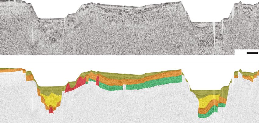
Lithosphere 3
Adventure Plateau
Piera 1
Paola est 1 Piera1 Paola est1
Sicily Sea level 0 m Ribera Fm. 0m
Seabed 105 (Pleistocene) 113
−200 No data
(Tortonian-Messinian)
AP 182
)
Terravecchia Fm.
an llo F Mio Fm.
ne
G-1
ian m ce
45 −600
r a
−4
en me we un
(Fig 00
(C A (Lo Fort
.)
−2
-E .
. 11
oc
−400 ) 00
Pantelleria Is.
om ri
NB
Mahmoud Fm.
−200 (Serravallian)
MB
Sill intrusion 1197
M
Hybla Fm.
S-
(Lower Cretaceous)
34
Egeria 1
GB Chairamonte Fm.
-3
25
NT MS-1 B1 (Lower Cretaceous)
M-
−6
11 −600 −8
PA
Buccheri Fm.
00
00 (Middle Jurassic)
OP
PG −1200 B2
Sciacca Fm. 1980
M
MS-122
CR
S-1
(Lower Jurassic-Triassic)
16
B
−6
Fig. 7
(F
Madrepora Bank
00 MH
ig
Egeria 1
.5
T-2 BS −1600 MG
−800
)
Sea level 0m
B3
PA N
−8 00
9)
272
−1
Seabed
00
.
B4 Fig −1
2
−1
(
40 No data
-1
000
4
PH 0 200 m
P M-2
NT
0 584
−40
PA
ig. 10)
ig. 6)
B6
(Cenomanian-Eoc.)
CRO
Parts of the seismic lines B5
Amerillo Fm.
Messinian
8B (F
19 (F
reported in the paper unconformity
M
LS S-
MS-1
14 Unconformity
MS-11
Exploration Thrust
borehole
−600
MG M Limestone
MS multichannel LP alt
ese
seismic profiles Is. Dolostone
(Lower Cretaceous)
Sand
MS-120
MS
PANT multichannel
8A
. 8)
Hybla Fm.
-12
seismic profiles
MS-11
Clay and marl
g
(Fi
−1
1
00
-19
CROP multichannel 0
7A
−8
MS
seismic profiles
00
Fig.
CS89-01 multichannel seismic Linosa Is.
−6
Chairamonte Fm.
profile (Torelli et al., 1991)
00
(Lower Cretaceous)
−1
Multichannel seismic profiles −10400 LG
00 Buccheri Fm.
of the Italian Commercial Zone G Inici Fm. (Middle Jurassic)
(Lower Jurassic) 3118
Multichannel seismic profiles −1000 20 km Sciacca Fm.
of the Italian Commercial Zone C (Lower Jurassic-Triassic)
Figure 2: Position of the exploration boreholes and multichannel seismic reflection profiles used in this study. The parts of the seismic lines
presented in this paper are also indicated. Bathymetric data extracted from EMODnet (http://www.emodnet-bathymetry.eu/) Digital Terrain
Model (1/16∗1/16 arc minutes). AP: Adventure Plateau; BS: Bannock seamount; GB: Gela Basin; LG: Linosa graben; LP: Linosa Plateau; LS:
Linosa III seamount; MB: Madrepora Bank; MG: Malta graben; MH: Malta High; NB: Nameless Bank; PG: Pantelleria graben; PH: Pelagian
High.
and internal deformation of the Plio-Quaternary basin fills, of the northern continental margin of the African plate (the
and the distribution of the magmatic bodies. These aspects so-called Pelagian Block of [19]) and represents the area
have allowed to propose a tectonic evolution that signifi- not affected by the emplacement of thrust sheets of the
cantly differs for the PG and the southern MG with respect Sicilian-Maghrebian collisional system (Figure 1(b)). The
to the central part of the SCRZ comprising the LG and the crustal thickness of the Pelagian foreland ranges from 25 to
northern MG, being separated by lithospheric 35 km [20], except in the Pantelleria Island area where the
discontinuities. crust does not exceed 17 km [21] due to continental rifting
processes. The foreland succession, which outcrops in SE Sic-
2. Tectonic Background ily (Hyblean Plateau) and in Tunisia (Sahel) (Figure 1(b)),
has been mainly analyzed by seismic and well data. On a
The tectonic evolution of the Central Mediterranean, where crystalline basement [22] rests a sedimentary succession con-
the Sicilian Channel is located, is related to the NNW- sisting of a thick, up to over 5 km, Triassic and Lower Jurassic
oriented Neogene convergence between African and Euro- shallow water carbonates overlain by Jurassic-Eocene pelagic,
pean plates [13–15], which led to the closure of the Neo- slope, and open-shelf carbonates, up to 2 km thick, followed
Tethys Ocean and the coeval collision between the European by Oligocene-Miocene open-shelf clastic deposits [3, 18, 23,
and African continental margins. 24]. The Plio-Pleistocene sedimentary cover consists of ter-
In this geodynamic context, a chain-foredeep-foreland rigenous, pelagic, and hemipelagic sediments, which that
system was developed today consisting of the Sicylian- generally does not exceed a thickness of 500 m [24–26]. Sev-
Maghrebian chain, the Gela foredeep, and the Pelagian fore- eral extensive depositional hiatuses have been recognized in
land, respectively. These tectonic domains can be identified the carbonate successions, as well as tuff and pillow lavas
in the Sicilian Channel (Figure 1(b)): (1) the Pelagian fore- deposited during a number of volcanic episodes [27].
land, mainly made of shallow and deep water Meso- Water depth of the Sicilian Channel is in general less than
Cenozoic carbonates; (2) the Plio-Pleistocene Gela foredeep, 200-250 m, except in its central part where a continental rift-
filled by over 2 km of clastic sediments; and (3) the frontal ing process, started since Early Pliocene, generated three
part of the Sicilian-Maghrebian chain, a complex orogen NW-oriented deep tectonic grabens (PG, LG, and MG)
mainly generated during the Neogene times and developed (Figure 1), leading to the development of the SCRZ [2, 3, 5,
from Southern Italy to North Africa across the Sicilian and 6, 12, 21, 28]. These grabens, where water depth ranges from
Sardinia Channels [16–18]. 1300 m to more than 1700 m, are filled by up to 2000 m thick
The Pelagian foreland, which includes the study area, Plio-Pleistocene deposits and are bounded by NW-trending
occupies most of the Sicilian Channel (Figure 1(b)). It is part subvertical normal faults [6]. Three hypotheses have been
Downloaded from http://pubs.geoscienceworld.org/gsa/lithosphere/article-pdf/2021/1/7866771/5226102/7866771.pdf
by guest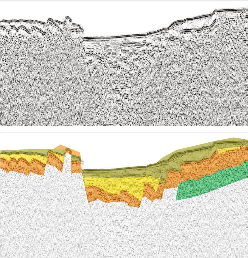
4 Lithosphere
GB FI
TB Sicily
AP
CV
NB
Pantelleria Is.
MB
B1 GB
PG
B2
BS
MG
B3 MH
B4
PH
B5 B6
Separation belt
LS Tr Ma
LP ltes
0m e Is.
−500 m
MT
−1000 m
LG
−1500 m Linosa Is.
−2000 m
−2500 m
Lampedusa Is.
20 km
Figure 3: Detailed morphobathymeric map of the central part of the Sicilian Channel, including the study area (dashed line), extracted from
EMODnet (http://www.emodnet-bathymetry.eu/) Digital Terrain Model (1/16∗1/16 arc minutes). The study area. AP: Adventure Plateau;
B1: Basin 1; B2: Basin 2; B3: Basin 3; B4: Basin 4; B5: Basin 5; B6: Basin 6; BS: Bannock seamount; CV: Cimotoe Volcano; FI: Ferdinandea
Island; GB: Graham Bank; GB: Gela Basin; LG: Linosa graben; LP: Linosa Plateau; LS: Linosa III seamount; MB: Madrepora Bank; MG:
Malta graben; MH: Malta High; NB: Nameless Bank; PG: Pantelleria graben; TB: Terrible Bank; Tr: morphological threshold.
formulated to explain the origin of the SCRZ: (1) the grabens component of movement along the CGSFZ has been sup-
are large and discrete pull-apart basins developed along a posed [28, 34, 38–40].
major dextral wrench zone [3, 28–33]; (2) the rifting is asso- A scattered anorogenic volcanism is widespread in the
ciated with mantle convections developed during the roll- Sicilian Channel mainly occurred during Plio-Pleistocene
back of the African lithosphere slab beneath the Tyrrhenian times [41], but eruptive events are documented until the his-
Basin [4, 34]; and (3) a mechanism of intraplate rift, related torical time, as testified by the 1831 submarine eruption of
to NE-directed displacement of Sicily away from the African Ferdinandea Island on the Graham Bank (Figures 3 and 4)
continent [35–37]. [42] and by the 1891 eruption occurred about 5 km off the
The central part of the Pelagian foreland is also crossed NW coast of Pantelleria Island [43, 44]. Part of this volca-
by the Capo Granitola-Sciacca Fault Zone (CGSFZ), a nism is related to the rifting process, and it includes the Qua-
roughly NNE-oriented, lithospheric strike-slip fault zone or ternary alkaline volcanic islands of Linosa and Pantelleria,
“separation belt” of [4, 7–11, 24, 38, 39] (Figure 1). It is inter- the submarine volcanic centers (Anfitrite, Tetide, and Gala-
preted as a transfer zone separating tectonically independent tea) located in the central part of the Adventure Plateau
sectors of the Sicilian-Maghrebian chain, and mainly devel- (Figure 1(a)), and other manifestations observed along the
oped during Early Pliocene [7]. Some authors suggested that PG and LG [21, 41, 45–51]. The several submarine volcanic
the CGSFZ might be responsible for the Sicilian Channel manifestations recognized on the Graham and Terrible
continental rift configuration between the western sector, Banks and in the nearshore of Capo Granitola-Sciacca coast
marked by the PG, and the eastern one, where the rift is of Sicily, together with Cimotoe Volcano (Figure 4) [41, 42,
splitted into the LG and MG [4, 10, 24]. Therefore, the 52–59], are located within of a nearly NS-oriented belt
CGSFZ might extend for 200 km from the Linosa Island to bounded by the faults of the CGSFZ, and their origin has
the Sicily coast between Capo Granitola and Sciacca Town been related to the rising of magmas along its lithospheric
(Figure 1). Its northern part consists of two major fault sys- master faults [7]. Finally, at the eastern termination of the
tems, the Capo Granitola Fault System to the west (CGFS) Nameless Bank (Figures 3 and 4), a volcanic manifestation
and the Sciacca Fault System to the east (SFS) ([7]; with an inferred age of 9:5 ± 0:4 Ma has been identified [60].
Figure 4), both dominated by a transpressional tectonics [7, The Gela foredeep or Gela Basin is a WNW-ESE-trend-
11]. The CGFS and SFS show clear evidence of Quaternary ing, narrow, and weakly deformed elongated depocenter
tectonic activity [7, 11]. A currently left-lateral strike-slip formed during Plio-Quaternary times. This basin was
Downloaded from http://pubs.geoscienceworld.org/gsa/lithosphere/article-pdf/2021/1/7866771/5226102/7866771.pdf
by guest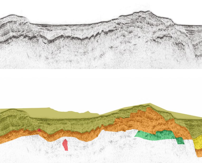
Lithosphere 5
12˚00′ 13˚00′ 14˚00′
20 km
Sciacca
Sicily
Agrigento
−200 NeB
Gel
aN Licata
app Gela
e
37˚00′
−200
−600 −4
00 −2
Pantelleria Is. −400
Gela F 00
oredeep
−200
G-145
B1
−6
−600 −8
00
0 00
−120
B2
−60
0 −800 −1600
B3
Study area
−8 00
−1
00
−1
B4 −140
2
0
000
0
Separation belt −40
B6
Magmatism B5
a Buried magmatic
b manifestation Tr
a Outcropping magmatic −600
b manifestation
(a: known; b: recognized in this paper)
36˚00′
Tectonic Structures
Axial surface of
−1
anticline 000
−8
00
Faults: Pliocene-Quaternary kinematics
Strike-slip fault Linosa Is.
−6
Maltese Is.
00
−14
Normal fault −10 00
00
Transpressive fault
Normal fault reactivated −1000
as transpressive/reverse fault
Figure 4: Structural map of the central part of the Sicilian Channel and distribution of the magmatic manifestations. The structural
lineaments and magmatic manifestations reported outside the study area (dashed line) derive from Civile et al. [7], for the Capo
Granitola-Sciacca Fault Zone (CGSFZ), and Cavallaro et al. [64]. For the Scicli-Ragusa Fault System (SRFS) has been reported the present-
day supposed kinematics [81]. The position of the Gela Nappe and Gela foredeep derives from various authors [38, 66, 68]. The position
of the interpreted seismic lines is also reported (black lines). AP: Adventure Plateau; B1: Basin 1; B2: Basin 2; B3: Basin 3; B4: Basin 4; B5:
Basin 5; B6: Basin 6; BS: Bannock seamount; CGFS: Capo Granitola Fault System; CGSFZ: Capo Granitola-Sciacca Fault Zone; CV:
Cimotoe Volcano; FI: Ferdinandea Island; GB: Graham Bank; GB: Gela Basin; LG: Linosa graben; LP: Linosa Plateau; LS: Linosa III
seamount; MB: Madrepora Bank; MG: Malta graben; MH: Malta High; NB: Nameless Bank; NeB: Nerita Bank; PES: Pantelleria Est
seamount (after Pantelleria graben); PH: Pelagian High; SFS: Sciacca Fault System; SRFS: Scicli-Ragusa Fault System; TB: Terrible Bank;
Tr: morphological threshold.
developed in the offshore of SE Sicily, parallel to the coast in Fm.) of the NE-oriented Adventure foredeep lying on a
front of the south-verging Plio-Pleistocene Gela Nappe [61] Mesozoic-Cenozoic carbonate substrate [8, 65–67]. This sec-
(Figure 1), which represents the outermost and youngest tor of the chain was affected by a Late Miocene compres-
thrust sheet of the Sicilian-Maghrebian chain [16, 18, 38, sional phase [9, 66–69], which produced ESE-verging
62–64]. The formation of the Gela foredeep has been associ- thrusts and associated back thrusts deforming also the
ated with the flexure of the foreland, due to loading of the Adventure foredeep [24, 49, 70]. This offshore sector of the
Gela Nappe [16]. The CGSFZ separates the Gela foredeep chain is limited to the east by the Adventure Thrust Front
and the offshore part of the Gela Nappe by a western offshore [8] (Figure 1(a)).
sector of the Sicilian-Maghrebian chain that includes the On the basis of the available well data (Figure 2) and lit-
Adventure Plateau (Figure 1(a)). This western sector hosts erature information [7, 24, 11, 38, 64, 71, 72], the sedimen-
the Tortonian-Lower Messinian deposits (Terravecchia tary succession of the study area can be summarized as
Downloaded from http://pubs.geoscienceworld.org/gsa/lithosphere/article-pdf/2021/1/7866771/5226102/7866771.pdf
by guest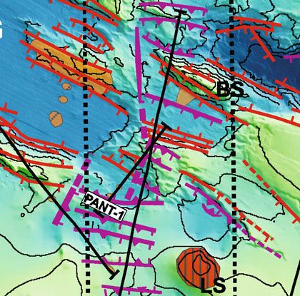
6                                                                                                                                              Lithosphere

                follows: the lower part consists of Upper Triassic (Sciacca                                          volution, and (3) prestack time migration (by an iter-
                Fm.) and Lower Jurassic (Inici Fm.) carbonate platform                                               ative velocity analysis). Finally, the post-migration
                deposits covered by a Jurassic-Eocene pelagic succession,                                            processing steps applied were (1) FX deconvolution,
                composed of limestones with marly and clayey intercalations                                          (2) time-variant filter (TVF), and (3) an amplitude
                up to over 2500 m thick (Buccheri, Chiaramonte, Hybla, and                                           balancing
                Amerillo Formations); on this succession rests an Oligocene-
                                                                                                                 (ii) Ten MS seismic lines acquired in the framework of
                Middle Miocene shallow water to pelagic carbonate succes-
                                                                                                                      the project Mediterranean Sea (MS project; [75,
                sion, up to 700 m thick, with siliciclastic intercalations (Boni-
                                                                                                                      76]) (Figure 2 and Table 1). This geophysical investi-
                fato, Ragusa, Fortuna, Nilde, and Mahmoud Formations)
                                                                                                                      gation was performed by OGS from 1969 to 1982.
                covered by the siliciclastic foredeep deposits of the Late
                                                                                                                      The MS lines used in this paper are the only available
                Tortonian-Early Messinian Terravecchia Fm. characterized
                                                                                                                      seismic data that allow to investigate the geological
                by considerable thickness variations from about 250 m to
                                                                                                                      setting of the extensive area of the Pelagian foreland
                over 2000 m; some tens of meters of Messinian evaporites
                                                                                                                      including LG and MG, the Linosa Plateau, and
                of the Gessoso-Solfifera Group can be locally present. The
                                                                                                                      (together with the seismic line PANT-1) the sector
                Late Oligocene-Lower Messinian succession presents differ-
                                                                                                                      that separates the LG and MG from the PG (Figure 2)
                ent lithological features in the Maltese area [73, 74]. This suc-
                cession, which can reach a thickness of 1000 m, consists of                                      The re-processing workflow carried out for the MS lines
                shallow-water bioclastic limestones (Lower Coralline Lime-                                   can be summarized in the following steps: (1) trace editing,
                stone Fm.), marly limestones (Globigerina Limestone Fm.),                                    (2) geometry assignment, (3) deghosting, (4) shot and
                hemipelagic clays, and marls (Blue Clay Fm.) that area                                       receiver interpolation, (5) multiple attenuation (SRME
                unconformably overlain by a shallow water reef deposits                                      followed by WEMA), (6) Q factor compensation, and (7)
                (Upper Coralline Limestone Fm.). The lower part of the                                       amplitude recovery and surface consistent predictive decon-
                Plio-Quaternary succession is composed of pelagic marls                                      volution. Deghost algorithm allowed to recover the lost fre-
                and marly limestones correlated with the Zanclean Trubi                                      quencies (due to source and streamer depth) and
                Fm. in Sicily. The succession ends with the Piacenzian-                                      consequently increase temporal resolution. The interpolation
                Pleistocene shelf clayey deposits with sandy and carbonate                                   in shot and receiver domains was done in order to reduce the
                intercalations of the Ribera Fm.                                                             spatial aliasing effects, so that the fold coverage of the MS
                                                                                                             lines was increased to 2400% before the SRME application.
                3. Materials and Methods                                                                     Prestack Kirchhoff time migration (PSTM) was done itera-
                                                                                                             tively while updating the velocity field: after several residual
                The results presented in this paper are based on the seismos-                                velocity analysis iterations, the final optimum velocity field
                tratigraphic and structural interpretation of a seismic dataset                              was obtained. The final post-migration processing steps
                (Figure 2) that has been uploaded and analyzed using the                                     applied were (1) FX deconvolution, (2) TVF, and (3) trace
                Kingdom Suite® seismic package. Morphobathymetric data                                       equalization.
                have been also uploaded to better constrain the position of
                the tectonic structures (Figure 3). The latter data largely                                      (iii) A densely spaced network of 2-D multichannel seis-
                derive from EMODnet Digital Terrain Model (grid-size:                                                  mic reflection profiles and borehole data made avail-
                1/16∗1/16 arc minutes) and extracted from the following                                                able by the Italian Ministry of the Economic
                link: http://www.emodnet-bathymetry.eu/. The morpho-                                                   Development in the framework of the project “Visi-
                bathymetric data also include the high-resolution multibeam                                            bility of Petroleum Exploration data in Italy”
                data collected in May 2009 by the R/V OGS Explora in the                                               (ViDEPI database; http://www.videpi.com). The
                area of the PG and in the sector that separates MG and PG                                              used dataset includes 25 seismic profiles belonging
                (published in Civile et al. [6]).                                                                      to the Italian commercial zones C and G (Figure 2
                    The seismic dataset consists of multichannel seismic                                               and Table 2). These data were acquired by AGIP
                reflection profiles collected during several seismic survey                                              (now ENI E&P) for hydrocarbon exploration during
                campaigns realized over a long period of time (between                                                 the 1960s and 1980s, respectively, in expired mining
                1960s and 2000s) in the Sicilian Channel. It includes the                                              permits and concessions. These lines have been
                following:                                                                                             mainly used to define the geological setting of the
                                                                                                                       northern sector of the study area that includes the
                       (i) Three multichannel seismic reflection profiles, for a                                         SE part of the Adventure Plateau and the Nameless
                           total length of about 170 km, collected in May 2009                                         and Madrepora Banks (Figure 2)
                           by the R/V OGS Explora within the central-eastern
                           part of the PG (PANT-2 and 3 already published in                                     These seismic lines available as raster files were converted
                           Civile et al. [6]) and in the separation belt between                             to SEG-Y format files using Seismic Unix free software.
                           PG and MG (PANT-1) (Figure 2 and Table 1). Spe-
                           cific processing of these data consisted of (1) multiple                               (iv) Part of the multichannel seismic lines M-25 and M-
                           removal using both the surface-related multiple elim-                                      24 acquired during the 1995s in the framework of the
                           ination (SRME) and the wave equation multiple                                              Italian Deep Crust Project (CROP) and the profile
                           attenuation (WEMA) methods, (2) predictive decon-                                          CS89-01 (Figure 2)

Downloaded from http://pubs.geoscienceworld.org/gsa/lithosphere/article-pdf/2021/1/7866771/5226102/7866771.pdf
by guest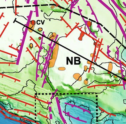
Lithosphere 7
Table 1: Acquisition parameters of the multichannel seismic profiles MS and PANT used in this study.
Project name MS PANT
MS-111, MS-116, MS-118A/B, MS-119, MS-120, MS-121, MS- PANT-1, PANT-2,
Line name MS-14, MS-19, MS-34
122 PANT-3
Vessel Marsili Marsili OGS Explora
Recording date 1970/1972 1980/1982 2009
Sample rate (ms) 4 4 2
Record length (s) 10 8.0/10.0 9.0
Fold (%) 1200 1200 3000
Recording filters 10-72 Hz 8/12-62 Hz Anti-alias
Energy source Flexotir Flexotir Sleeve guns
3 guns, microcharges of 8 sleeve guns of 2450 cu.
Source array 2 guns, microcharges of 50 g
50 g in.
Streamer (m) 2400 2400 1500 (1200)
Channel 24 48 120 (96)
Group interval
100 50 12.5
(m)
Shot interval (m) 200 100 25
Table 2: Acquisition parameters of the multichannel seismic tion [77]; the velocity field was smoothed to avoid
profiles of the ministerial lines of the zones G and C. artefacts due to strong lateral variations and was used
to perform the first PSDM.
Survey Zone G Zone C
Vessel M/V Artic Seal Not available (2) The grid tomography was used to update the velocity
Recording data 1982 1968 model; it tends to minimize the travel time errors
between modeled and real ray paths changing trajec-
Sample rate (ms) 2 2
tory and velocity of seismic waves in each cell of the
Record length (s) 8 5
grid.
Fold (%) 4800 1200
Recording filters 8–128 Hz 10-80 Hz (3) New PSDM with the updated velocities and quality
control on the common image gathers (CIG) were
Energy source Airgun array AquaPulse
carried out. Steps 2 and 3 have been repeated until
Source array (charge size) 2000 cu.in. Not available
the CIG showed a satisfactory flatness of the
Streamer (m) 2400 1600 reflections.
Channel 96 24
Group interval (m) 25 67 The seismic velocity field obtained for the Plio-
Shot interval (m) 25 134
Quaternary sedimentary fill of the LG and the northern
MG ranges from roughly 1550 m/s in the uppermost part of
the grabens to over 3500 m/s in the deepest one of the north-
ern MG. The time vs. depth charts and the associated interval
Three AGIP exploration boreholes are located in the velocity functions for the PG and the northern MG are
study area. Two wells (Piera 1 and Paola 1) are positioned included in the Supplementary Material.
on the south-eastern sector of the Adventure Plateau, while A velocity analysis has been performed on the Plio-
the Egeria 1 well is located on the top of the Madrepora Bank Quaternary succession of the PG along the seismic line MS-
(Figure 2). 116, where the maximum thickness of the sedimentary cover
Seismic lines are displayed in a two-way time (TWT) is reached. The interval velocity profile was derived from the
except for two prestack depth-migrated (PSDM) parts of Dix formula [77] and used for the time-to-depth conversion.
the seismic line MS-119 that cross orthogonally LG and the It is reported in the Supplementary Material, along with the
northern MG. The PSDM has been done using a 2D grid corresponding table.
tomography approach in order to obtain an accurate The time-to-depth conversion was used to calculate the
velocity-depth model. The iterative workflow for the grid maximum thickness of the Plio-Quaternary sedimentary fill
tomography approach can be summarized into three main of the grabens in order to evaluate the average sedimentation
steps: rate for the last 5.33 Ma (Miocene-Pliocene boundary [78])
and thus hypothesize the age of the main observed unconfor-
(1) The starting velocity field was obtained by the con- mities. The interval velocities obtained for the northern MG
version of the RMS velocity field (previously obtained have been also used as a reference for the southern part of
for PSTM) into interval velocities through Dix equa- the MG.
Downloaded from http://pubs.geoscienceworld.org/gsa/lithosphere/article-pdf/2021/1/7866771/5226102/7866771.pdf
by guest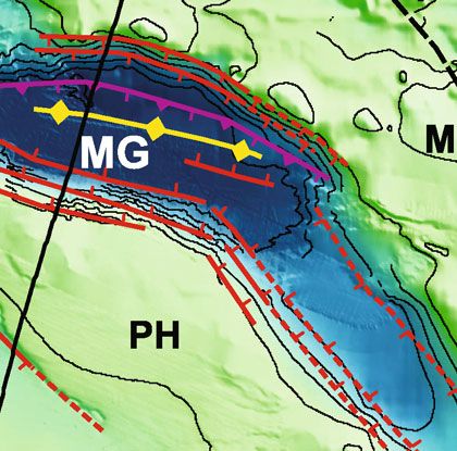
8                                                                                                                                              Lithosphere

                    The seismostratigraphic interpretation of the seismic                                    (Figure 3). The latter represents the emergent summit of a
                lines was made through the recognition of key reflectors, cor-                                large submarine volcanic complex (Figures 3 and 4). The
                responding to lithological changes and/or unconformities,                                    eastern part of the PG, which presents a rectangular shape,
                bounding seismic units characterized by distinctive seismic                                  is bounded by N115°-120° trending linear margins
                features (e.g., amplitude, lateral continuity, and frequency                                 (Figures 3 and 4). This sector is characterized by a flat bottom
                of internal reflectors), and then by correlating them with                                    with a maximum water depth of 1350 m. The NE margin of
                the stratigraphy derived by the hydrocarbon wells and litera-                                the PG consists of a steep scarp up to 700 m high, while along
                ture information. Since the main focus of the present work                                   the SW margin, several structural highs are recognizable.
                was the Plio-Quaternary tectonic evolution, the zones of                                         The Adventure Plateau, characterized by a flat top with
                greatest interest were the PG, LG, and MG (Figures 5–8),                                     water depth between 50 m and 150 m, shows a slope gently
                characterized by the most complete and continuous Plio-                                      inclined towards the PG affected by several NW-oriented tec-
                Quaternary sedimentary record. The unconformities visible                                    tonic scarps (Figures 3 and 4).
                in the basins have been recognized on the basis of the reflec-                                    A NNE-oriented depression, about 12 km wide, separates
                tion terminations as onlap, downlap, and truncation.                                         the Adventure Plateau from the Nameless Bank. This depres-
                    The magmatic manifestations have been inferred on the                                    sion hosts several small semicircular-shaped morphological
                basis of the following features: (a) distinctive geometry,                                   highs, the largest of which is the Cimotoe Volcano
                which generally consists of dome-shaped and discordant                                       (Figure 3). The Nameless Bank is a large plateau up to
                intrusive bodies; (b) seismic facies consisting of discontinu-                               40 km wide and 30 km long, with water depth around 120-
                ous and chaotic reflectors that interrupt the continuity of                                   150 m, that rapidly narrows to the east (Figure 3).
                the seismic reflectors associated with the sedimentary succes-                                    The MG and LG show a more articulated shape and a
                sion; (c) reflective and high-amplitude top that precludes                                    smaller width compared to the PG (Figure 3). The MG
                acoustic penetration and showing diffraction hyperbola; (d)                                   develops for over 160 km with a sigmoidal shape (Figure 3).
                possible presence of acoustic velocity jumps; and (e) tilting/-                              It presents a variable trend from ~N110° in the northwestern
                folding of the reflectors around the potential magmatic                                       sector to ~N140° in the remaining part of the graben. A max-
                intrusions.                                                                                  imum width of about 22 km is observed in the northwestern
                                                                                                             of the graben, while in the southern one, the MG widens up
                4. Data Interpretation                                                                       to 30 km at the SE edge of the Pelagian High [after 28]
                                                                                                             (Figure 3). The maximum water depth of roughly 1700 m is
                The morphobathymetric and structural maps of the investi-                                    reached in the northwestern part of the MG that is bounded
                gated area are shown in Figures 3 and 4, respectively. The                                   by scarps up to over 1300 m high.
                structural setting of the northern sector of the Sicilian Chan-                                  MG and LG are separated by the over 50 km wide Linosa
                nel located outside the study area is derived from the data                                  Plateau, whose maximum elevation is the Pelagian High
                reported in Civile et al. [7] (Capo Granitola-Sciacca Fault                                  (Figure 3). The SE edge of this high consists of a 650 m high
                Zone) and in Cavallaro et al. [64] (north of Madrepora                                       steep tectonic scarp, which might extend to the NE forming a
                Bank-Gela foredeep) (Figure 4).                                                              morphological threshold (“Tr” in Figure 3) that separates
                     The distribution of the magmatic manifestations is also                                 into two parts of the MG.
                reported in Figure 4, and it includes the bodies identified in                                    The LG is the narrower depression of the SCRZ
                this work and those already known in literature. However,                                    (Figure 3), and it develops for about 45 km. The LG presents
                it is necessary to emphasize that the evidence of most of the                                a maximum width of about 20 km and a variable orientation
                magmatic bodies remains uncertain because of the lack of                                     from N140° in its northern part, where the maximum water
                available magnetic data in the study area and of detailed seis-                              depth of over 1550 m is reached, to about E-W in the south-
                mic velocity analysis on the used dataset. Therefore, the rec-                               ern one. The largely submerged Linosa volcanic complex
                ognition of magmatic intrusions is essentially supposed on                                   occupies the northern part of the southwestern margin of
                the basis of their seismic facies and shape. Finally, the areal                              the LG (Figure 3).
                extension and plain-view geometry of the mapped magmatic                                         The separation belt between the PG to the west and MG
                bodies is in some cases indicative.                                                          and LG to the east is characterized by the presence of shallow
                                                                                                             basins (numbered 1 to 6 from north to south) of different
                4.1. Morphobathymetric Analysis. The study area hosts three                                  shape and extension separated by structural highs
                prominent NW-trending grabens (PG, LG, and MG) consti-                                       (Figures 3 and 4). The most prominent reliefs are the 900 m
                tuting the core of the SCRZ, and a series of wide and shallow                                high-carbonate Bannock seamount [50] and the seamount
                flat-topped structural banks, composed of Meso-Cenozoic                                       of volcanic origin called Linosa III [53] (“BS” and “LS”,
                carbonate and siliciclastic successions covered by thin Plio-                                respectively, in Figures 2–4). This separation belt is limited
                Quaternary deposits (Figure 3). A narrow, roughly N-                                         to the north by the Nameless Bank and to the south by the
                trending separation belt, about 15-25 km wide, with a com-                                   Linosa volcanic edifice (Figure 3).
                plex morphobathymetry, separates the western sector of the
                SCRZ hosting the PG from the eastern sector occupied by                                      4.2. Seismostratigraphic Analysis. The oldest seismostrati-
                the LG and MG (Figure 3).                                                                    graphic unit recognizable in the seismic profiles consists of
                    The PG develops for about 125 km reaching a maximum                                      a Meso-Cenozoic pelagic carbonate succession (Figures 6
                width of over 40 km in the area of the Pantelleria Island                                    and 8–11) composed of a generally well-layered seismic

Downloaded from http://pubs.geoscienceworld.org/gsa/lithosphere/article-pdf/2021/1/7866771/5226102/7866771.pdf
by guest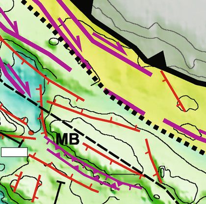
Lithosphere 9
Seismic Line MS-116
0.0
NW SE
1.0 Pantelleria graben Basin 5
2.0
TWT (s)
3.0
4.0
5 km
5.0
0.0
NW SE
1.0 Pantelleria graben Basin 5
VA
? ?
2.0 ? ?
U1
TWT (s)
? ? ?
?
? ?
3.0
4.0
5.0
A A) Undifferentiated Plio-Quaternary succession Unconformities in the Plio-Quaternary succession
B B) Plio-Quaternary syn-rift deposits associated with the SCRZ formation
Unconformity at the top of the Plio-Quaternary syn-rift deposits
Oligocene-Miocene succession Messinian unconformity
Normal fault reactivated as
Magmatic manifestation Normal fault transpressive/reverse fault
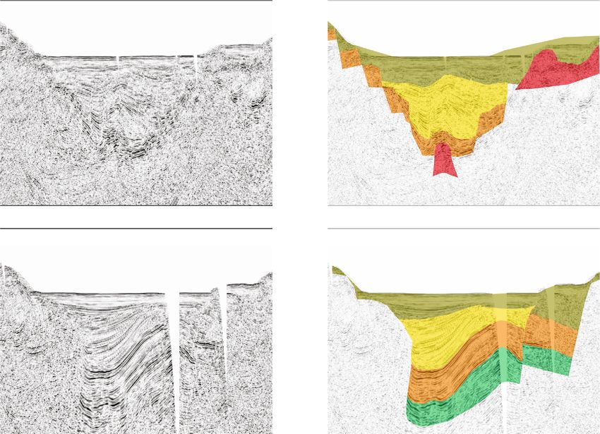
Figure 5: Part of the multichannel seismic reflection profile MS-116 and interpreted line drawing (location in Figure 2). Vertical exaggeration
about 3.5X. U1: unconformity at the top of the syn-rift deposits of the Pantelleria graben; VA: velocity analysis site of the Plio-Quaternary
succession of the Pantelleria graben (see Supplementary Material (available here)).
facies with low- to high-amplitude discontinuous reflectors. tation, mass wasting, and bottom currents [79]. The seismic
This succession can be locally chaotic. The top of the carbon- facies of the sedimentary fill of the grabens is characterized
ate succession (top of the Amerillo Fm.) is not always recog- by well-layered, laterally continuous, and parallel reflectors
nizable in the seismic data. Where it is identified, it consists with a generally high frequency (Figures 5, 6, and 8). It is pos-
of a high-amplitude and laterally discontinuous reflector dis- sible to identify an alternation of packages showing low to
sected by faults (Figures 6 and 8–11). The mixed siliciclastic- moderate or high amplitude. On the plateau areas, the Plio-
carbonate Oligocene-Miocene succession shows a consider- Quaternary succession is generally thin and characterized
able variability in terms of seismic facies and thickness. It by laterally continuous and parallel reflectors (e.g.,
generally consists of an upper part characterized by high- Figures 6, 8, and 9). The lower part of the Plio-Quaternary
amplitude reflectors resting on an alternation of low-to- succession of the basins often shows a growing wedge-
moderate amplitude seismic reflectors (Figures 6 and 8–11). shaped geometry produced by a syn-tectonic deformation
The reflectors are usually discontinuous and locally chaotic. associated with extensional processes (Figures 5, 6, 8, and
This succession is well-layered and characterized by continu- 10). Finally, a buried seismic body characterized by a chaotic
ous reflectors with low to high amplitude in the MG facies has been identified within the northern MG (Figure 6).
(Figure 6) and in the Adventure Plateau (Figure 11). The This large body might be a mass wasting deposits produced
top of the Oligocene-Miocene succession, which also repre- by landslides generated along the fault scarps bounding the
sents the base of the Plio-Quaternary deposits, is a prominent western part of the MG.
reflector associated with the Messinian unconformity. It is
seismically expressed by an undulated, high-amplitude, and 4.3. Structural Setting and Magmatism of the Sicilian Channel
continuous reflector that is generally well recognizable on Rift Zone (SCRZ)
all seismic lines. The Plio-Quaternary deposits of the grabens
consist of an alternation of sandy, pelitic, and more rarely 4.3.1. Pantelleria Graben. The structural setting of the PG
gravelly layers produced by the interaction of several pro- reported in Figure 4 derives from the interpretation of the
cesses including gravity-driven flows, hemipelagic sedimen- seismic profiles PANT-2 and 3 reported in Civile et al. [6],
Downloaded from http://pubs.geoscienceworld.org/gsa/lithosphere/article-pdf/2021/1/7866771/5226102/7866771.pdf
by guest
10 Lithosphere
Seismic Line MS-119
0.0 SSW
Pelagian High Malta High NNE
Linosa Plateau
1.0 Linosa graben Northern Malta graben
2.0
TWT (s)
3.0
4.0
10 km
5.0
0.0
SSW Pelagian High Malta High NNE
Linosa Plateau
Fig. 7(a) Fan delta Fig. 7(b)
1.0
Linosa graben Northern Malta graben
2.0 ? ?
TWT (s)
U2 ?
U1 U2
3.0 ? U1
4.0 ?
5.0
A A) Undifferentiated Plio-Quaternary succession Unconformities in the Plio-Quaternary succession
B B) Plio-Quaternary syn-rift deposits associated with the SCRZ formation
Unconformity at the top of the Plio-Quaternary syn-rift deposits
Oligocene-Miocene succession Messinian unconformity
Mesozoic-Eocene carbonate succession Top Mesozoic-Eocene carbonate succession
Normal fault reactivated as
Normal fault
Magmatic manifestation Mass wasting deposits transpressive/reverse fault
Figure 6: Multichannel seismic reflection profile MS-119 crossing the Linosa graben and the Northern Malta graben and interpreted line
drawing (location in Figure 2). Vertical exaggeration about 4.5X. U1: unconformity at the top of the syn-rift deposits; U2: main
unconformity recognized within the postrift succession.
of the NW-oriented seismic line MS-116 (Figures 2 and 5) the lower part of the Plio-Quaternary basin fill, located at
and of the ministerial seismic lines belonging to the Italian the southern termination of the PG, shows a growing
Commercial Zones G (Figure 2). wedge-shaped geometry (syn-rift deposits) with an increas-
The interpretation of the available dataset shows that the ing thickness and divergent fanning strata towards a NW-
SW margin of the PG is composed of structural highs dipping buried normal fault (Figure 5).
bounded by NW-trending, NE-dipping normal faults, and A widespread magmatism is present within the PG
separated by ENE-oriented normal faults, while the NE mar- (Figures 4 and 5), and its extent is probably underestimated
gin is controlled by a NW-trending master fault (Figures 3 due to the lack of a good seismic data coverage (Figure 2).
and 4). The SE termination of the PG consists of two The largest magmatic body, about 46 km long and 20 km
branches separated by a structural high affected by a wide wide, includes the partially outcropping volcanic complex
magmatic intrusion and bounded by NW-trending normal of the Pantelleria Island and its S-E extension (Figure 4).
faults (Figure 4).
The Plio-Quaternary sedimentary fill of the PG has a 4.3.2. Linosa Graben and Linosa Plateau-Pelagian High. The
maximum thickness of 1200 m (1.1 s TWT), as revealed by maximum thickness of the Plio-Quaternary sedimentary fill
the seismic line MS-116 (Figure 5). The base of the basin fill of the PG was estimated along the seismic line MS-119
is rarely visible in the seismic lines due to the presence of (Figures 6 and 7(a)), with a value of about 2200 m (1.78 s
widespread magmatism (Figure 5). The Plio-Quaternary suc- TWT). The LG is bounded on both sides by normal faults,
cession can be divided into two subunits separated by an arranged in a staircase configuration, dipping towards the
unconformity (U1 in Figure 5) that is recognizable along graben (Figures 6 and 7(a)). The pre-Pliocene basement of
the seismic profile as a high-amplitude reflector. The lower the LG is affected by fault-block deformation due to normal
part of the basin fill, which is about 900 m thick (0.79 s faults that cut the Messinian unconformity but not involving
TWT), is affected by a significant deformation, produced by the Plio-Quaternary succession. A thick Plio-Quaternary
both modest extensional faulting and by the emplacement succession up to 1550 m thick (about 1.125 s TWT), inter-
of magmatic bodies. The upper part consists of a roughly preted as syn-rift deposits that were later folded, rests on
250-300 m thick (0.3-0.36 s TWT) succession composed of the Messinian unconformity (Figures 6 and 7(a)). A thick-
subhorizontal, continuous, and undeformed reflectors, only ness (wedge-shaped geometry) of this succession towards
marginally affected by magmatism (Figure 5), except for the the N-NE master fault is recognizable. The post-rift succes-
Pantelleria Island zone. The seismic line MS-116 shows that sion, up to 800 m thick (about 0.82 s TWT), can be divided
Downloaded from http://pubs.geoscienceworld.org/gsa/lithosphere/article-pdf/2021/1/7866771/5226102/7866771.pdf
by guestLithosphere 11
Seismic Line MS-119
Linosa and Malta troughs (depth)
0 0
SSW NNE SSW NNE
500 500
Linosa graben Linosa graben
1000 1000
1500 1500
U2
2000 2000
U1
Depth (m)
2500 2500
3000 3000
3500 3500
4000 4000
4500 4500 ?
5000 5 km 5000
(a)
0 0
SSW NNE SSW NNE
500 500
1000 Northern Malta graben 1000 Northern Malta graben
1500 1500
2000 2000 U2
Depth (m)
U1
2500 2500
3000 3000
3500 3500
4000 4000
4500 4500
5000 5 km 5000
(b)
Figure 7: (a) Part of the depth-migrated multichannel seismic reflection profile MS-119 crossing the Linosa graben and interpreted line
drawing (location in Figure 2). U1: unconformity at the top of the syn-rift deposits; U2: main unconformity recognized within the postrift
succession. For the legend, see Figure 6. (b) Part of the depth-migrated multichannel seismic reflection profile MS-119 crossing the
Northern Malta graben and interpreted line drawing (location in Figure 2). Vertical exaggeration about 3X. U1: unconformity at the top
of the syn-rift deposits; U2: unconformity recognized within the postrift succession. For the legend, see Figure 6.
into an upper undeformed part and a lower folded-faulted The wide shallow bank located between LG and MG,
part separated by an unconformity (U2 in Figures 6 and comprising the Linosa Plateau and the Pelagian High
7(a)). The upper succession, up to 250-300 m thick (around (Figure 4), is a gentle syncline covered by a Plio-Quaternary
0.3 s TWT), consists of horizontal reflectors with onlap ter- succession with a maximum thickness of 0.52 s (TWT). The
minations against the basal unconformity. The lower syncline might be the result of a gentle downward bending
succession, up to over 500 m thick (0.48 s TWT), is in turn produced by the tectonic activity of the opposite-dipping
divided into two parts by another minor unconformity normal faults bounding the bank. An almost 0.25 s (TWT)
(Figures 6 and 7(a)). thick progradational sedimentary body interpreted as a Late
The Plio-Quaternary sedimentary fill of the LG seems to Pleistocene fan delta [72] is also recognizable in the Linosa
be affected by two main tectonic stages: (1) a rifting stage Plateau (Figure 6). The Linosa Plateau-Pelagian High block
starting from the Early Pliocene that led to the opening of is affected by several normal faults with modest throws that
the LT and (2) a basin inversion stage. were probably produced during the early stages of the open-
The major evidence of this inversion is the folding ing of the grabens of the SCRZ (Figure 6). The Plio-
that involved the syn-rift succession and part of the Quaternary succession shows onlap terminations against
post-rift deposits producing a wide anticline (Figures 6 the Messinian unconformity, allowing to infer that the
and 7(a)). The post-rift succession shows a progressive Linosa Plateau-Pelagian High was a preexisting structural
upward decrease in deformation. This anticline extends high.
for about 6-7 km with a NW direction (Figure 4). Evi- The magmatism present in the LG is mainly concentrated
dences of tectonic inversion (normal faults reactivated as along the margins of the graben. As in the case of the PG, the
reverse/transpressive faults) are visible along the faults extent of the magmatism is almost certainly underestimated
affecting the central part of the sedimentary fill due to the lack of a seismic data coverage. The volcanic com-
(Figures 6 and 7(a)). plex of the Linosa Island (Figure 4), with at least 96% of its
Downloaded from http://pubs.geoscienceworld.org/gsa/lithosphere/article-pdf/2021/1/7866771/5226102/7866771.pdf
by guest12 Lithosphere
Seismic Line MS-19
0.0
SW NE
Southern Malta graben
1.0
2.0
TWT (s)
3.0
4.0
5 km
5.0
0.0
SW NE
Southern Malta graben
1.0
U1
2.0
TWT (s)
3.0
4.0
5.0
Unconformity at the top of the
A A) Undifferentiated Plio-Quaternary succession
Plio-Quaternary syn-rift deposits
B B) Plio-Quaternary syn-rift deposits associated
with the SCRZ formation Messinian unconformity
Oligocene-Miocene succession Top Mesozoic-Eocene carbonate succession
Normal fault Normal fault reactivated as
Mesozoic-Eocene carbonate succession
transpressive/reverse fault
Figure 8: Multichannel seismic reflection profile MS-19 crossing the Southern Malta graben and interpreted line drawing (location in
Figure 2). Vertical exaggeration about 2.5X. U1: unconformity at the top of the syn-rift deposits.
areal extent lying below sea level [51], is the main magmatic thickness of the Plio-Quaternary sedimentary fill is around
manifestation. On the basis of the seismic facies visible in the 2000 m (1.52 s TWT) (Figures 6 and 7(b)). The interpretation
central part of the LG along the seismic lines MS-119 of the seismic line MS-119 (Figures 6 and 7(b)) shows that
(Figure 6), consisting of a high-amplitude and chaotic body the lower part of the Plio-Quaternary succession of the
of limited extension overlapped by Miocene deposits, the northern sector of the MG is up to about 1300 m thick (about
possible presence of magma ascent along the axis of the LG 0.85 s TWT) and is characterized by a growing wedge-shaped
can be inferred (Figure 4). geometry with an increasing thickness and divergent fanning
strata toward the SW. Based on these evidences, this part of
4.3.3. Malta Graben. It is possible to discriminate two sectors the basin fill is interpreted as a syn-rift deposit related to
in the MG from a structural point of view (Figure 4): (1) a the opening stage of the MG. In addition to the unconformity
northern sector running from the Bannock seamount to the at the top of these deposits (U1), another minor unconfor-
SE edge of the Pelagian High and (2) a southern sector com- mity is visible within the syn-rift succession (Figures 6 and
prised between the Pelagian High and the Maltese Islands. 7(b)). A post-rift succession, up to 700 m thick (about 0.69 s
These two sectors are separated by a modest morphological TWT), unconformably covers the syn-tectonic deposits
high (“Tr” in Figures 3 and 4). The analysis of the available (Figures 6 and 7(b)). It is separated in a lower mildy folded
seismic profiles did not allow to recognize evidence of mag- part, up to 300 m thick (about 0.3 s TWT), and in an upper
matic bodies neither within the MG nor along its margins. undeformed part, up to about 400 m thick (0.45 s TWT), by
an unconformity (U2 in Figures 6 and 7(b)). The lower part
4.3.4. “Northern Sector of the Malta Graben.” The northern of the post-rift succession possibly consists of syn-tectonic
sector of the MG, showing an almost symmetric shape, is tec- deposits associated with the formation of the wide anticline,
tonically controlled by high-angle, WNW- to NW-oriented developed for at least 25 km in a WNW direction
normal faults dipping towards the graben and arranged in a (Figure 4), involving also the pre-Pliocene basement of the
staircase configuration (Figures 4 and 6). The maximum MG and the syn-rift succession (Figures 6 and 7(b)). The
Downloaded from http://pubs.geoscienceworld.org/gsa/lithosphere/article-pdf/2021/1/7866771/5226102/7866771.pdf
by guestLithosphere 13
Seismic Line PANT-1 MS-118B
0.0
SW NE
1.0
TWT (s)
Basin 4
2.0
2 km
3.0
MS-118B
0.0 SW NE
1.0
Basin 4
TWT (s)
2.0 ?
?
3.0
A A) Undifferentiated Plio-Quaternary succession
B B) Plio-Quaternary syn-rift deposits associated with the SCRZ formation Magmatic manifestation
Oligocene-Miocene succession
Normal fault reactivated as
Normal fault Reverse fault
Mesozoic-Eocene carbonate succession transpressive/reverse fault
Unconformities in the Plio-Quaternary succession Messinian unconformity
Unconformity at the top of the Plio-Quaternary syn-rift deposits Top Mesozoic-Eocene carbonate succession
Figure 9: Part of the multichannel seismic reflection profile PANT-1 and interpreted line drawing (location in Figure 2). Vertical
exaggeration about 4.5X.
anticline might be the result of the reactivation in compres- NW-oriented and SW-dipping normal faults (Figures 4 and
sion/transpression of the normal fault located at the base of 8). The maximum thickness of the Plio-Quaternary sedimen-
the northern margin of the MG. The sedimentary fill of the tary fill is about 1500 m (about 1.3 s TWT) as seen along the
northern sector of the MG seems to be affected, as well as that seismic line MS-19 (Figure 8). The graben imaged in this line
of the LG, by two main tectonic stages: (1) a rifting stage is over 20 km wide with a seafloor gently inclined towards the
starting from the Early Pliocene that led to the opening of SW margin (Figure 8). A Plio-Quaternary sedimentary body
the MG and (2) a second stage of basin inversion character- with a wedge-shaped geometry characterized by an increas-
ized by the development of a wide anticline and inversion ing thickness and divergent fanning strata toward the NE
of normal faults. has been recognized; it has been interpreted as a syn-rift
deposit. The latter is up to about 1100 m thick (ca. 0.9 s
4.3.5. “Southern Sector of the Malta Graben.” The southern TWT) and is affected by several SW-dipping normal faults
sector of the MG has a southern steep margin tectonically with vertical throws rapidly decreasing upwards (Figure 8).
controlled by a NW-trending and NE-dipping master fault, The unconformity at the top of the syn-rift deposits (U1 in
and a gently inclined northern margin affected by several Figure 8) is covered by a slightly deformed post-rift
Downloaded from http://pubs.geoscienceworld.org/gsa/lithosphere/article-pdf/2021/1/7866771/5226102/7866771.pdf
by guest14 Lithosphere
Seismic Line MS-118B
PANT-1
0.0
SSW NNE
Bannock seamount
1.0 Basin 4 Basin 2
Basin 3
2.0
TWT (s)
3.0
4.0
5 km
5.0
PANT-1
0.0
SSW NNE
Bannock seamount
1.0 Basin 4 Basin 2
Basin 3
2.0
TWT (s)
?
3.0
4.0
5.0
Figure 10: Part of the multichannel seismic reflection profile MS-118B and interpreted line drawing (location in Figure 2). For the legend, see
Figure 9. Vertical exaggeration about 3.5X.
succession that thins toward the SW (Figure 8). The SW side ness and seismic facies. Moreover, this tectonic structure
of the graben is characterized by a series of half-grabens separates areas characterized by a different structural setting
bounded by generally SW-dipping, high-angle normal faults (Figure 5): (1) the PG to the west exhibits an extensional
(Figure 8). The lower part of the Plio-Quaternary fill of the deformation and (2) the area located to the east of the master
half-grabens, which is characterized by a growth wedge- fault, that is the Basin 5, is mainly affected by a transpres-
shaped geometry associated with thickening and divergent sional deformation. These structural evidences suggest that
fanning reflectors down the dip slope of the tilted fault this master fault might be NNE-oriented and a strike-slip
blocks, is interpreted as a syn-rift deposit. A different struc- component of motion might be occurred along it (Figures 3
tural setting characterizes the NE margin of the MG, where and 4). Seismic data suggest that this fault and the associated
evidences of positive tectonic inversion, consisting of high- Basin 5 suffered a polyphase tectonic evolution (Figure 5). (1)
angle and NE-dipping normal faults reactivated as reverse/- It is probable that the Basin 5 developed during a first phase
transpressive faults, are recognizable (Figure 8). In particular, dominated by extensional deformation started from Early
some faults maintain normal throws at depth changing to Pliocene. In fact, its Plio-Quaternary sedimentary fill consists
reverse offsets up-dip, generating a mild bending. Moreover, of a lower part, interpreted as a syn-rift succession, character-
most of the inverted faults deform the seafloor. ized by a growth wedge-shaped geometry associated with a
thickening down the south boundary fault (Figure 5). (2) A
4.4. Structural Setting of the “Separation Belt.” From south to second stage characterized by the tectonic inversion of the
north, the following seismic lines have been chosen to preexisting basin produced by transpressional reactivation
describe the structural setting of this area: MS-116, PANT- of the previous normal faults. The depocentre migrated from
1, and MS-118B (Figure 2). the southern margin of the Basin 5 towards its central part
The seismic line MS-116 (Figure 5) shows the structural (Figure 5).
setting of the Basin 5 (B5 in Figures 2–4), bounded to the The NE-oriented seismic line PANT-1 (Figure 9) crosses
NW by a master fault that juxtaposes two sectors character- the NW-SE-trending, relatively flat Basin 4 (B4 in Figures 2–
ized by successions with significant differences both in thick- 4), located at the southeastern termination of the PG. The
Downloaded from http://pubs.geoscienceworld.org/gsa/lithosphere/article-pdf/2021/1/7866771/5226102/7866771.pdf
by guestYou can also read