National report Denmark - IHO MSDIWG 17-18. marts. 2021
←
→
Page content transcription
If your browser does not render page correctly, please read the page content below
National report
                     Denmark

                        IHO MSDIWG
GEODATASTYRELSEN           17-03-2021      1
                      17-18. marts. 2021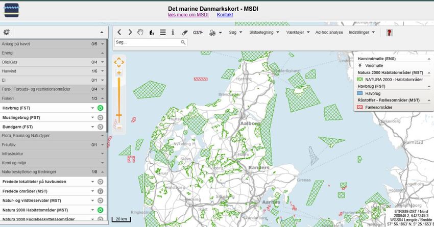
Danish Basic MSDI
• Allows users to
  visualize and use
  marine data
  from Danish
  marine
  authorities
• So far 84 Danish
  marine datasets
  are available

  GEODATASTYRELSEN        17-03-2021     2

                      Geodatastyrelsen
Obligations for participating authorities
       The participating authorities that contribute their data commit to:
       • Provide Webservices (WMS), Downloadservice and Metadata as agreed upon within the
       technical description of the MSDI
       • Identify a ”single point of contact”, which the MSDI secretariat can refer to in case of
       technical problems for an authority
       • Participate in the MSDI-forum

       Financing
       From 2020 DGA has taken the full financial responsibility.

       Priced data
       For some dataset, which are included in the MSDI, applies that they are priced, such as
       nautical chart data. It is the individual data owners that set the guidelines for use of their
       data including access criteria, payment models and international exchange.

GEODATASTYRELSEN                                   17-03-2021                                           3
Danish MSDI – Business case
The analysis has identified four main interest groups that will benefit from MSDI 2.0.
1. The 11 authorities that use and developed the current version of the MSDI and
   other authorities with an interest in the ocean.
2. Private companies; both existing marine compa-nies which can improve existing
   offerings and/or products and potential start-ups that can build their busi-ness
   models based on the opportunities provided in MSDI 2.0.
3. Researches, teachers and students who can use marine data from the MSDI in
   their research, work or studies.
4. Associations and individuals with an interest in the ocean, e.g. an interest in
   sailing, canoeing, kayaking, bird watching, etc.

     Danish Geodata Agency
     GEODATASTYRELSEN                                  17-03-2021                        4
Danish MSDI – Business case
An important step towards realising the Danish Government’s growth plan for ‘The
Blue Denmark’
Indicated a strong demand for a further development of the Danish MSDI as a free
and open data infrastructure for marine data
Showed an annual net benefit of DKK 2 million after implementation of the three-
step development plan and a positive net value over an 8 year period.
Several qualitative benefits, e.g.
    • improving authorities communication of decisions, rules and guidelines
    • new business opportunities for entrepreneurs
    • improved data accessibility for research
    • improvement of recreational apps and maps aimed at citizens.

     Danish Geodata Agency
     GEODATASTYRELSEN                           17-03-2021                         5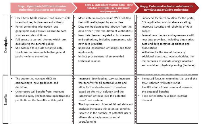
Danish MSDI – next step
Today the Danish MSDI are only accessible for the 11
marine authorities that participated in development of
the MSDI.
Business case: Benefits of and costs associated with
the further development of the MSDI
• Three-step development plan
    1. Open MSDI solution for all, e.g. authorities,
       businesses and citizens – Danish version
       opens april 2021

    2. Introduce more marine data
    3. Enhanced technical solution with tools and
       time-series data.

     Danish Geodata Agency
     GEODATASTYRELSEN                                  17-03-2021   6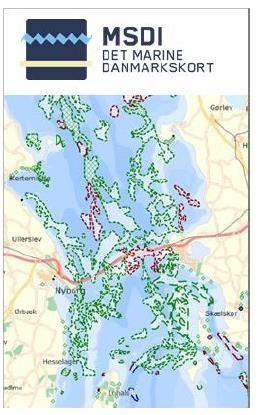
Danish MSP

GEODATASTYRELSEN       17-03-2021   7

A Digital Danish MSP
• Danish Maritime Authority (DMA) are currently developing a prototype in order for the first Danish
  MSP to be born as digitization-ready legislation via a digital map of Denmark and the Danish waters.
• The new Maritime Spatial Plan will be the first legally binding digital plan in the country and data
  and map in relation to the MSP will have a legal status.
• DMA are focused on developing a user-friendly MSP-platform. Meetings and interacting with the
  public sector should be transparent and easy. This, for example, means ensuring a more user-
  friendly and coherent user journey when several public authorities at different levels are involved.
• First version of the platform will be ready for national consultation in april 2021.
• DGA are participating in the project as advisory consultant.
• The Danish MSP is scheduled to enter into force in end of 2021.

    GEODATASTYRELSEN                             17-03-2021                                              8
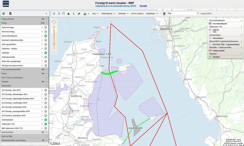
MSDI MSP platform for preliminary MSP
        • Only access for ministerial
          working group participants
        • Possible for agencies to
          share relevant draft data,
          which is not open for the
          public
        • Feedback from working
          group: simple and easy to
          use. Very useful for
          members to get a full
          overview of the many
          information which are
          used in drafting an MSP
           GEODATASTYRELSEN                                17-03-2021            9

17. marts 2021                          Geodatastyrelsen                Side 9
GEODATASTYRELSEN 17-03-2021 10
Legally binding digital maps
• Denmark is working towards publishing all spatial data digitally
  in the future. The new Maritime Spatial Plan will be the first
  legally binding digital plan in the country.
• In recent years, the Danish authorities have frequently
  discussed how maps appended to laws and regulations are
  designed, so that there is no doubt regarding which physical
  area a given legal rule applies to.
• In beginning of 2020, DGA together with Agency for Data
  Supply and Efficiency and Danish Maritime Authority published
  a leaflet, where a number of issues, which should be further
  investigated as part of the process of establishing an
  infrastructure for digital publication of the geography of legal
  rules. Link
• In June 2020 national guidelines for use of geography in Danish
  legislation was published. Link to Danish version
 GEODATASTYRELSEN                                   17-03-2021       11
You can also read