Near Southside Development Standards & Guidelines - Prepared by Near Southside, Inc. in cooperation with the City of Fort Worth November 5, 2020
←
→
Page content transcription
If your browser does not render page correctly, please read the page content below
Near Southside
         Development Standards
                  & Guidelines

         Prepared by Near Southside, Inc.
in cooperation with the City of Fort Worth
                       November 5, 2020
TABLE OF CONTENTS
SECTION 1 - INTRODUCTION        (This page intentionally left blank)    (4)
      A. Background                                                     (4)
      B. Promoting Revitalization with Form-Based Code                  (5)
      C. Hemphill Corridor                                              (6)

SECTION 2 - GENERAL DEVELOPMENT PRINCIPLES                              (8)
      A. Intent                                                         (8)
      B. General Development Principles                                 (8)

SECTION 3 - ADMINISTRATION                                             (10)
      A. Intent                                                        (10)
      B. Relationship to Other Regulatory Documents                    (10)
      C. Definition of “Standards” and “Guidelines”                    (10)
      D. Development Review Process                                    (11)
      E. Near Southside District Boundary                              (14)

SECTION 4 - REGULATING PLAN                                            (16)
      A. Intent and Principles                                         (16)
             1. How to Use the Regulating Plan
             2. The Transect Classification System
      B. Maps of Development Zones and Historic Properties             (20)
      C. Circulation Network and Street Design                         (24)
             1. Primary and Main Streets Map
             2. CFW Near Southside - Master Thoroughfare Plan

SECTION 5 - DEVELOPMENT STANDARDS AND GUIDELINES                       (26)
      A. Intent and Principles
                                                                       (26)
      B. Streets and Other Public Spaces
                                                                       (30)
             1. Street Standards
             2. Public Roadsides
             3. Roadside Elements
             4. Public Parks and Plazas
             5. Public Art
                                                                       (44)
      C. Building Location and Orientation
             1. Base Setback Standards
             2. Contextual Setback Standards
             3. Pedestrian Entrances
             4. Fencing
             5. Drive-Through Standards
             6. Sky Bridges
      D. Building Height
                                                                       (49)
             1. Height Guideline
             2. Building Heights
             3. Building Heights Along Primary Streets
             4. Height Bonus Requirements
             5. Fairmount Transitional Height Plane
             6. Hemphill Transitional Height Plane
SECTION 5 - DEVELOPMENT STANDARDS AND GUIDELINES (cont.)
    E. Parking and Driveways                                 (52)
           1. Off-Street Parking Requirements
           2. Surface Parking Cap
           3. Surface Parking Lots
           4. Maximum Surface Parking Lot Frontage
           5. Surface Parking Screening
           6. Scaled Residential Garages
           7. Structured Parking and Multi- Level Garages
           8. Driveway Locations
           9. Drop-Off and Loading Zone Areas
    F. Architectural Standards                               (54)
           1. Roofs
           2. Parallel Frontages
           3. Entrances
           4. Awnings, Galleries, Arcades and Balconies
           5. Facades
           6. Screening of Mechanical Equipment
           7. Architectural Variety in Large Projects
           8. Outdoor Storage Display
           9. Mobile Court Review
           10. Signs
    G. On-Site Landscaping                                   (76)
           1. Tree Preservation and Canopy Requirements
           2. Front Yard Landscaping Guideline
           3. City Approved Canopy Tree List
SECTION 6 - PERMITTED LAND USES                              (78)
      A. Mix of Use Requirement for Large Developments       (78)
      B. Special Requirements for “N” , “R”, and “H” Zones   (80)
      C. Permitted Land Use                                  (81)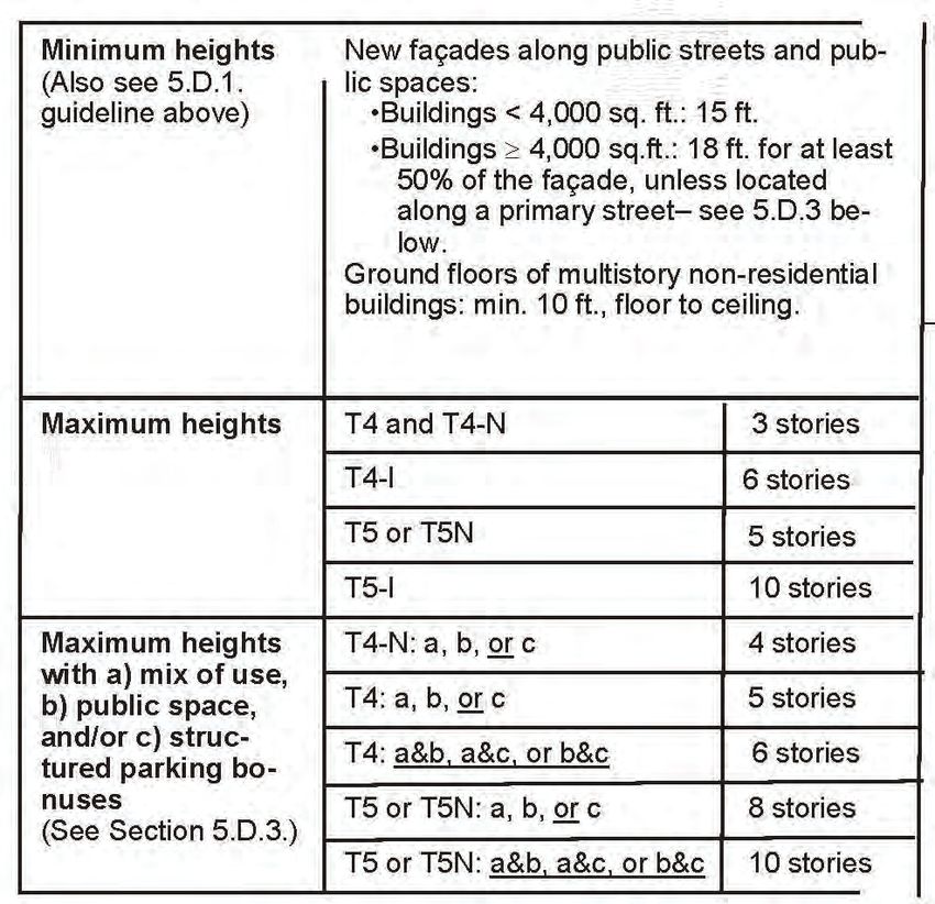
SECTION1.INTRODUCTION
               1.A. Near Southside District Background
                       The Near Southside is located just south of Downtown Fort Worth and is the city’s second
               largest employment center, with over 40,000 workers, many of whom are employed in the health
               care industry. Although commonly recognized today as the “Medical District,” the area has
               historically been a mixed-use district with diverse neighborhoods and eclectic destinations. The
               area’s remaining historic buildings – with their architectural diversity, human-scale design, and
               wide range of locally-owned businesses – reflect this storied past.

               Fort Worth South, Inc. (FWSI), a non-profit redevelopment corporation, has worked since 1996
               with the City of Fort Worth and other community groups to promote the area’s revitalization in a
               way that builds on this history and capitalizes on the district’s eclectic, mixed-use, human-scale
INTRODUCTION

               character to create a competitive advantage in attracting new residents and businesses. Urban
               design (i.e., the design of buildings, streets, and other public spaces, and the interrelationships
               among those elements) will continue to be a major factor in determining the district’s economic,
               social, and cultural sustainability. Promoting the sustainability of neighborhoods and commercial
               districts is a primary goal for the City of Fort Worth.

 (4) Near Southside District
1.B. Promoting Revitalization with Form-Based Development Standards
        As reflected in the City’s Comprehensive Plan (which includes the FWSI strategic plan by
reference), FWSI and the City have long recognized the importance of urban design in realizing
revitalization goals for the Near Southside. As in the past, the district’s future character will largely
be determined by the individual design decisions made by hundreds of property owners,
businesses, and residents over the following decades. The City’s zoning regulations and other
development standards play perhaps the most influential role in guiding these decisions, and,
as a result, in shaping the Near Southside’s character, quality of life, and sustainability.

       For decades, zoning regulations, street design requirements, and other development
standards have worked against urban design and redevelopment goals for the Near Southside
and other central city districts. In response, the City adopted new form-based “MU” mixed-use
zoning classifications, and, in certain central city areas such as Downtown and Panther Island,
created new urban design districts with tailored development standards and guidelines that
promote development that is consistent with the contextual design goals for those respective
areas.

FWSI has worked with property owners to promote desirable redevelopment in two ways: first,
through rezoning to the “MU” classifications; and second, through the application of informal
design guidelines. Although the effects of these past efforts have been significant, a
comprehensive update of the district’s development standards – through the creation of a new
Near Southside urban design district overseen by the Urban Design Commission – is necessary
to promote the district’s continued revitalization, for several reasons:
•   The patchwork of single-use industrial, commercial, and residential zoning districts did not
    allow or promote a mix of residential, retail, office, and institutional uses as envisioned in the
    City’s Comprehensive Plan, within which the Near Southside is designated as a “mixed-use
    growth center.”
•   Outdated development standards did not promote the type of pedestrian-oriented urban design
    that characterizes the Near Southside’s most distinctive and memorable areas and serves as a
    competitive advantage for the district.
•   The patchwork of zoning districts threatened redevelopment momentum by failing to create
    a predictable investment environment in which property owners could confidently invest in
    redevelopment projects that conformed to the district’s vision and be reasonably assured that
    zoning standards would require compatible development on adjacent properties.
•   The wide range of conditions within the district – from lower density residential neighborhoods
    to large institutional campuses – required a more tailored approach than simply applying all of
    the “MU” standards throughout the area.
•   Design excellence, administrative flexibility, and timely approval of conforming projects would
    best be promoted through a development review process overseen by a well-qualified design
                                                                                                                INTRODUCTION

    review board, as demonstrated by the Downtown Urban Design District process.
•   This illustrated document uses photographs and other images in an effort to create a user-
    friendly manual for use by professional developers as well as non-experts. The standards
    and guidelines contained are largely based on the form-based standards of the “MU”
    classifications. Form-based standards differ from conventional zoning standards in their
    emphasis on shaping the form of buildings and public spaces rather than the segregation of
    different land uses.
                                                                                        Near Southside District (5)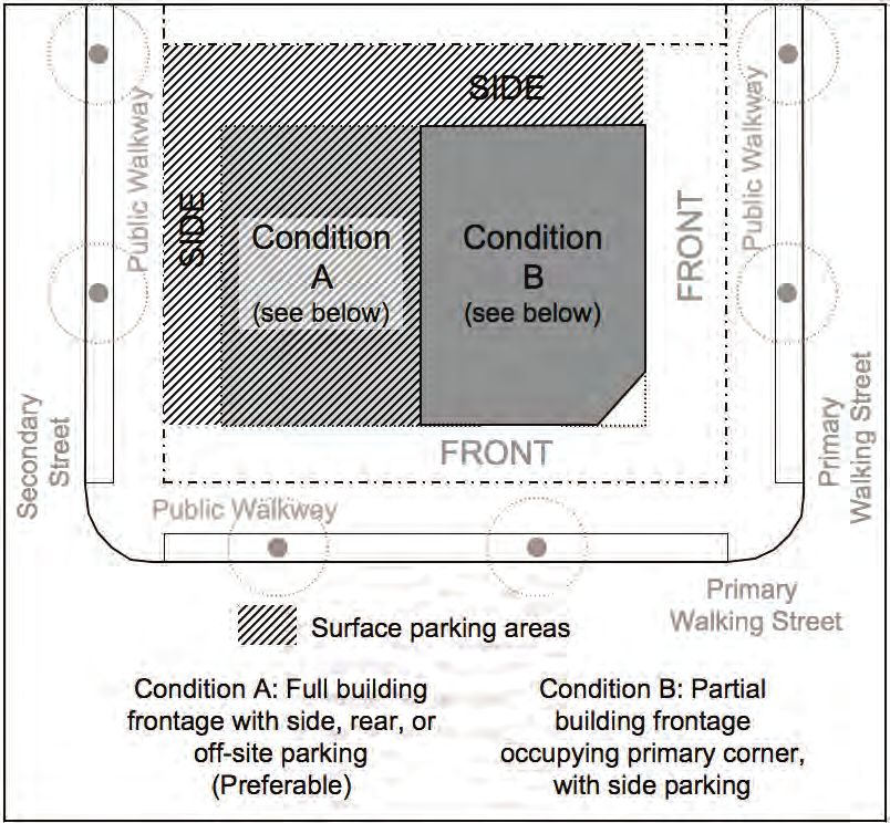
1.C Hemphill Corridor
                      The Hemphill Corridor stretches over 5 miles from I-30 south to I-20 and borders more
               than eight neighborhoods and over 5,000 residential homes. For over 100 years this historic
               boulevard has been a key artery from downtown through the Near Southside and to our southern
               communities. The re-urbanization of Fort Worth makes Hemphill Street the best location for
               creating a ‘Complete Street’ to unify residents, businesses, transportation, and community needs.
               Hemphill Street already provides the necessary social and commercial infrastructure to become a
               grand boulevard once again with family centric neighborhoods, green space, historic structures,
               mixed use properties, existing community centers, and a myriad of architectural character.

               Hemphill Street significantly complements the Near Southside which is the City’s second largest
               employment center. With the success of Magnolia Street, the Hemphill Corridor offers the area
               much needed opportunity for residential infill, accessible commercial space, and true historic
               character. The established neighborhoods along the Hemphill Corridor to add to the overall
               character and stability of the Near Southside.

               Hemphill Corridor Task Force, a City Council initiated, volunteer organization has worked for over
               30 years with the City of Fort Worth, local community groups, and local businesses to promote
               the corridor’s revitalization in a way that builds on its history, unique properties, businesses and
               most importantly the neighborhood citizens that make the area surrounding the corridor their
               home.

                                                     Image Placeholder
INTRODUCTION

 (6) Near Southside District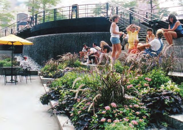
The Hemphill Corridor Task Force has worked with neighborhoods, property owners, and
businesses to promote desirable redevelopment in three ways: First, promotion of the corridor
as a ‘Complete Street’; second, the right-sizing/re-striping of the street to improve safety for
citizens and to enhance commercial activity; and thirdly upgrading/rezoning to the “MU” and “PD”
classifications of several properties to be more in line with supported uses. A more uniform code
and guidelines will permit property owners to understand the long-term direction and benefits of a
more harmonious development structure along the corridor.

The success of the Near Southside and surrounding district encourages an expansion of the district’s
development standards along the Hemphill Corridor. The Hemphill Corridor Task Force provided design
input to revise the existing standards which will be administered by the Urban Design Commission.
These standards are necessary to promote the district’s continued revitalization for several reasons.

                                        Image Placeholder

                                                                                                        INTRODUCTION

                                                                                Near Southside District (7)
SECTION2.GENERALDEVELOPMENTPRINCIPLES
                                 2.A. Intent
                                 The Near Southside will become a vibrant, mixed-use, urban district if certain general
                                 development principles shape its redevelopment. The following principles serve as the basis for
                                 the standards and guidelines contained in this document. Development projects are evaluated
                                 with respect to the principles, in addition to the pertinent standards and guidelines.

                                 2.B. General Development Principles
                                 1. Promote a pedestrian-oriented urban form: In contrast to conventional zoning standards
                                    that place primary emphasis on the regulation of land uses, the Near Southside development
                                    standards and guidelines focus on promoting a walkable, urban form of development,
                                    consistent with the district’s historic urban character. The focus on form promotes buildings
                                    that conform to tested urban design principles, and that adapt to changing conditions over
                                    time.

                                 2. Maximize connectivity and access: The Near Southside’s successful revitalization
                                    requires a truly multi-modal circulation network in which residents, workers, and visitors may
                                    conveniently walk, drive, bike, or ride public transportation to destinations within and outside of
                                    the district. Development standards and guidelines are intended to promote walkable blocks
                                    and street designs that balance these transportation modes, and also ensure accessibility for
                                    all residents and visitors, including those with disabilities.

                                 3. Require excellence in the design of the public realm (building on Fort Worth’s history of
                                    civic art) and of buildings that front public spaces: The most successful and memorable
                                    urban environments are those in which walking down the street is appealing. Streets, plazas,
                                    parks, and other public spaces should be comfortable and inviting, and buildings fronting those
                                    spaces should be active and visually interesting at the pedestrian level. Providing a medium
GENERAL DEVELOPMENT PRINCIPLES

                                    scale and infill residential options for various household types and income levels is critical to
                                    the district. The Missing Middle housing typologies reflect historical residential patterns and
                                    create diverse housing options espoused.
                                 4. Promote the preservation and creation of distinctive neighborhoods that provide
                                    diverse urban housing options: The vision for the Near Southside places high priority on
                                    the creation of mixed-use, mixed-income neighborhoods that include townhouses, apartments,
                                    condominiums, and supporting neighborhood-scale businesses. Providing a large number
                                    of units and options for various household types and income levels is critical to the district’s
                                    success. Providing a medium scale and infill residential options for various household types
                                    and income levels is critical to the district. The Missing Middle housing typologies reflect
                                    historical residential patterns and create diverse housing options espoused.

                                 5. Support existing Near Southside and Hemphill Corridor businesses: The Near Southside
                                    development standards and guidelines should support the success of existing businesses.

    (8) Near Southside District
6. Encourage adaptive reuse and support the preservation of historically significant
   buildings: The Near Southside includes historically significant buildings that should be
   incorporated into new development projects. The development standards and guidelines are
   intended to work in conjunction with the City’s Historic Preservation Ordinance to encourage
   preservation and adaptive reuse of significant buildings.

                                                                                                            GENERAL DEVELOPMENT PRINCIPLES
7. Encourage creativity, architectural diversity, and exceptional design: The Near Southside
   development standards and guidelines promote high quality design, and the development
   review process promotes flexibility. Standards and guidelines, as well as the development
   review process, are intended to support creativity and exceptional design while discouraging
   uniformity.

8. Promote sustainable development that minimizes negative impacts on natural
   resources: Creating a walkable, mixed-use, high-density, central city district supports
   sustainable development by providing an alternative to low-density development in peripheral
   areas. In accordance with sustainable development principles, the Near Southside’s buildings,
   transportation systems, and public spaces should be designed to minimize negative impacts
   on air and water quality and promote innovation in environmental design.

9. Encourage the integration of public art into public and private development: Public art
   should be integrated into architecture, streetscapes, and public spaces. Public art will enhance
   the built environment and contribute to the area’s success in attracting new residents and
   businesses.

                                                                                    Near Southside District (9)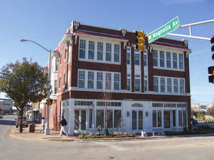
SECTION3.ADMINISTRATION
                 3.A. Intent
                 The development standards and guidelines included in this document are intended to be clear,
                 concise, and user-friendly. The development review process is intended to be predictable and
                 flexible, and to facilitate the timely approval of conforming projects.

                 3.B. Relationship to Other Regulatory Documents
                 The Near Southside (NS) Development Standards and Guidelines document is intended to
                 minimize references to other sections of the City’s Zoning and Subdivision ordinances.
                 Developers are responsible, however, for reviewing and complying with all pertinent zoning and
                 subdivision standards, including those not directly referenced in this document.

                 There are two notable references to other sections of the Zoning Ordinance:
                        a) the Historic Preservation Ordinance (Chapter 4, Article 5), which includes the procedures
                        and requirements related to the preservation and reuse of historically significant buildings;
                        and,
                        b) Off-Street Parking and Loading (Chapter 6, Article 2)

                 All development must comply with all federal, state, county, or city regulations. Historically
                 designated properties must comply with requirements associated with those designations (e.g.,
                 Fairmount Historic District properties must comply with that district’s design guidelines as well as
                 processes required by the Historic and Cultural Landmarks Commission).

                 3.C. Definition of “Standards” and “Guidelines”
                 Development Standards are objective, measurable regulations, often illustrated through diagrams
                 and sketches, with which all projects must comply. Unless noted as a guideline, all provisions in
                 this document are development standards. If a project of exceptional design is clearly consistent
                 with the General Development Principles but does not conform to a certain development standard,
                 the Urban Design Commission (UDC) may approve a Certificate of Appropriateness (COA) that
                 cites the project’s compliance with those principles. (For projects not conforming to the height
                 and setback regulations, a variance approved by the Board of Adjustment is also required; see
                 Development Review section below.)

                 Development Guidelines are more subjective statements though which the City proposes
                 additional design strategies. The guidelines should be suitable for most projects, and developers
ADMINISTRATION

                 should endeavor to ensure that guidelines are followed to the extent possible. City staff and the
                 UDC will work with developers to explore design approaches that maximize conformance with
                 guidelines. The UDC shall not deny a Certificate of Appropriateness solely because a project fails
                 to comply with a guideline.

  (10) Near Southside District
3.D. Development Review Process
1. Projects subject to review: All private
construction projects, with the exception
of interior construction or exterior in-kind
replacement work, are subject to review by REVIEW OF PUBLIC PROCESS
the Development Services Department and/
or the Urban Design Commission (UDC)
for compliance with the NS Standards and
Guidelines. All buildings, streets, and public
spaces by public entities are also subject to
review.
2. Hemphill Corridor Conception Phase
Presentations/Discussions: These
preliminary discussions take place when
private party/submission group/developer/ Proposed West Rosedale streetscape improvements
(Rendering by Carter & Burgess, Inc.).
property owner provides initial project concept
or UDC submission to Development Committee In addition to private construction projects, public
of Hemphill Corridor Task Force. The Task projects such as street and streetscape
improvements are subject to review for consistency
Force and the project party will conducts a with the standards and guidelines.
work session, and provide an opportunity
for early comments from the Task Force and
should facilitate timely design review and initial
comments during the design phase. City staff
encourages all public and private developers
of significant projects to present their conceptual plans to the Task Force either before or after
submission to the UDC. This process for Hemphill Corridor is similar to that of existing process
with Near Southside.
3. Administrative Review VS. UDC Review: Projects that are clearly consistent with all
applicable development principles and that clearly conform to all standards may be approved
administratively by the Development Services Director without UDC review. Staff may
administratively approve waivers from roadside design elements for properties located along
a street that is planned for a sponsored streetscape project. Because of the unique signage
needs of the major hospitals, staff may also approve appropriate hospital signage that deviates
from the dimensional standards. The UDC shall review projects that require interpretation or
discretionary judgment with respect to the project’s compliance with standards and guidelines. ADMINISTRATION
The UDC shall also review all of the following:
• Skybridges (see Section 4.C.6)
• Drive-through Facilities (see Section 5.D.5.)
• Mobile Food Courts (see Section 4.F.8.)
• Monument Signs (see Section 4.F.9.a)
• New Curb Cuts/Driveways (see Section 4.D.8) - this is applicable only on Hemphill
south of Allen Avenue
Near Southside District (11)3.D. Development Review Process (cont.)
4. Urban Design Commission (UDC): The UDC is a nine-member body appointed by the City
Council and charged with the administration of urban design districts. As stated above, the
UDC shall review projects that require interpretation or discretionary judgment with respect
to the project’s compliance with standards and guidelines. The Zoning Ordinance specifies
that UDC appointees should be knowledgeable about fundamental principles of urban design.
Furthermore, at least six of the nine appointees shall be practicing professionals from the fields
of architecture, landscape architecture, urban design or planning, real estate, or law. At least
one of the nine regular member appointees must be a practicing or retired professional in the
field of history, architectural history, or other discipline related to historic preservation. The
Development Services Director serves as staff advisor to the UDC.
5. Certificates of Appropriateness (COA): The Development Services Director or UDC will
issue a Certificate of Appropriateness for approved public and private projects. In exceptional
cases the UDC may approve a COA if a project is clearly consistent with applicable
development principles but does not conform to a certain development standard(s) or
guideline(s). The COA for such projects must describe the projects’ compliance with applicable
principles.
6. Required Information: The full list of required materials is included in the Near Southside
District application available from the City’s Development Services Department, 817-392-8000,
www.fortworthtexas.gov/developmentservices/urban-design.
In general, the following information is required, as applicable:
a. Site Plan
b. Building Plans and Elevations
c. Landscape Plan
d. Material Specifications
e. Plans and Specifications for Proposed Signs
f. Description of Proposed Scope of Work
g. Photographs of Site and Existing Conditions
7. Review of Phased Projects: To minimize review steps for phased development projects, the
UDC may approve a COA for all phases provided that the applicant submits drawings that
depict the initial phase as well as all future phases. The COA is valid for two years from the
date of approval.
ADMINISTRATION
8. Variances to Zoning and Subdivision Ordinances’ Property Development Standards:
The UDC is authorized to approve appropriate exceptions to the vast majority of the NS
Standards and Guidelines, provided a project complies with applicable development principles.
The UDC may allow additional flexibility for projects of exceptional civic or environmental
design. Any waiver of basic property development standards related to building heights or
setbacks, however, requires a variance approved by the Board of Adjustment. Similarly,
vacations of public rights-of-way and any waivers of subdivision requirements require approval
by the City Plan Commission. Variances, vacations, and subdivision waivers should be
recommended for approval by the UDC. The UDC is authorized to approve exceptions to
roadside design standards.
(12) Near Southside DistrictCONCEPTUAL DESIGN REVIEW
Developers are strongly encouraged to present conceptual plans for large and/
or multi-phase projects at an early stage to facilitate timely review during the final ADMINISTRATION
design phase.
Near Southside District (13)3.E. Near Southside District Boundary
See Section 4 for development zone map with parcels
ADMINISTRATION
(14) Near Southside DistrictADMINISTRATION Near Southside District (15)
SECTION 4. REGULATING PLAN

                  4.A. Intent and Principles
                  The Near Southside Regulating Plan functions similarly to both the Zoning Ordinance map and
                  the Master Thoroughfare Plan map. The NS Regulating Plan includes maps that depict the
                  boundaries of different types of development zones, as well as maps identifying the location and
                  classification of thoroughfares. These maps serve as a guide for determining which development
                  standards and guidelines apply to a development project. A unified section that classifies both
                  development zones and streets is intended to promote coordination among land use, urban
                  design, and transportation decisions, which is an essential strategy in creating a vibrant, livable,
                  mixed-use district. The following principles guide the content of the Regulating Plan.

                  DEVELOPMENT ZONES
                  1. Draw development zone boundaries so as to enhance the character of
                  existing neighborhoods and commercial districts while also promoting compatible
                  higher-density, mixed-use redevelopment in appropriate locations.
                  2. Draw development zone boundaries to promote a large number of new
                  residential units in order to create a “live, work, play” environment and to support
                  neighborhood retail and other commercial uses.
                  3. Draw development zone boundaries to support large institutions and
                  businesses that warrant tailored development standards based on their unique
                  operational requirements.

                  HISTORIC PROPERTIES
                  4. Facilitate the incorporation of historically significant buildings into
                  redevelopment projects by identifying those properties on the Regulating Plan
                  and by referencing the Zoning Ordinance’s Historic Preservation Ordinance and
                  applicable incentives.
                  5. Facilitate the designation of currently unprotected historic properties and their
                     adaptive reuse by identifying the most eligible properties on the Regulating
                     Plan as information on those properties becomes available.

                  CIRCULATION NETWORK AND STREET DESIGN
                  6. Preserve the existing urban street grid to maximize street connectivity for
REGULATING PLAN

                     vehicles, pedestrians, public transportation, and bicycles. The grid promotes
                     efficient circulation and provides a wide range of mobility options.
                  7. Limit vacations of existing public rights-of-way, including streets and alleys,
                     only to situations where there is no adverse impact to future circulation and
                     desirable redevelopment, or in cases where such vacations are absolutely
                     necessary for an exceptional redevelopment project that is clearly consistent
                     with the general development principles.
                  8. Utilize context-sensitive street design that gives equal consideration to
                     redevelopment and mobility goals.

  (16) Near Southside District
4.A. Intent and Principles (cont.)
1. How to Use the Regulating Plan
1. Locate the subject property on the applicable development zone and
historic properties map in Section 4.B.
Sample section of
development zone
map. See pages
20-23.
2. Identify the property’s development zone and any applicable historic
designations.
3. Locate the subject property on the primary and main street map in
Section 4.C.
Sample section of
primary/main street
map. See page 24.
REGULATING PLAN
4. Identify subject property and adjacent primary and/or main streets if any.
5. Refer to Sections 5-7 for applicable standards and guidelines related to
streets, streetscapes, public spaces, sites, and buildings.
6. Refer to Chapter 4, Article 5 of the Zoning Ordinance for
regulations pertaining to historic properties.
7. Refer to all other referenced sections of the Zoning Ordinance or other
regulatory manuals.
Near Southside District (17)4.A. Intent and Principles (cont.)
2. The Transect Classification System
The diagram below illustrates the “Transect” that serves as the basis for many form-based
development codes. The Transect diagram shows a continuous cross-section of human habitats,
from rural to urban. Transect zones “T4: General Urban” and “T5: Urban Center” are most
consistent with the redevelopment vision for the Near Southside. (The development standards
for T4 and T5 are very similar to those for the MU-1 and MU-2 zoning districts, respectively.) T4
and T5 zones, as well as special neighborhood and institutional/industrial zones are shown on the
development zone maps in the following section.
REGULATING PLAN
Source: SmartCode v8.0, Duany Plater-Zyberk & Company
(18) Near Southside DistrictREGULATING PLAN Near Southside District (19)
4.B. Development Zones and Historic Properties
                                                                               HISTORIC PROPERTIES
                  1. Northwest Quadrant                                        (Refer to of Zoning Ordinance Ch. 4, Art. 5)
                                                                                  Local Designations
                                                                               HSE - Highly Significant Endangered
                                                                               HC - Historic and Cultural Landmark
                                                                               DD - Demolition Delay

                  Basic Development Standards (Standards and guidelines are listed in Sections 5-7.)

                         20-ft. maximum front setback                                 Neighborhood zone
                   T4    18-foot minimum façade height                         -N     No single-use non-residential
REGULATING PLAN

                         3 stories max. if single use                                 3 stories max., 4 stories w/ public
                         5 stories max. w/ public space or mix of uses                space or mix of uses
                         6 stories max. w/ public space and mix of uses
                         Parking behind or beside buildings                           Institutional/Industrial zone
                                                                                -I    Flexible driveway and entrance
                         20-foot maximum front setback                                standards
                   T5    18-foot minimum façade height
                         5 stories max. if single use
                         8 stories w/ public space or mix of uses                     Restricted zone
                         10 stories w/ public space and mix of uses            -R     No bars or industrial
                         Parking behind or beside buildings                           uses; see p. 44.
  (20) Near Southside District
HISTORIC PROPERTIES
2. Northeast Quadrant (Refer to of Zoning Ordinance Ch. 4, Art. 5)
Local Designations
HSE - Highly Significant Endangered
HC - Historic and Cultural Landmark
DD - Demolition Delay
Basic Development Standards (Standards and guidelines are listed in Sections 5-7.)
20-ft. maximum front setback Neighborhood zone
T4 18-foot minimum façade height -N No single-use non-residential
3 stories max. if single use 3 stories max., 4 stories w/ public REGULATING PLAN
5 stories max. w/ public space or mix of uses space or mix of uses
6 stories max. w/ public space and mix of uses
Parking behind or beside buildings Institutional/Industrial zone
-I Flexible driveway and entrance
20-foot maximum front setback standards
T5 18-foot minimum façade height
5 stories max. if single use
8 stories w/ public space or mix of uses Restricted zone
10 stories w/ public space and mix of uses -R No bars or industrial
Parking behind or beside buildings uses; see p. 44.
Near Southside District (21)4.B. Development Zones and Historic Properties (Cont.)
HISTORIC PROPERTIES
3. Southwest Quadrant (Refer to of Zoning Ordinance Ch. 4, Art. 5)
Local Designations
HSE - Highly Significant Endangered
HC - Historic and Cultural Landmark
DD - Demolition Delay
Basic Development Standards (Standards and guidelines are listed in Sections 5-7.)
20-ft. maximum front setback Neighborhood zone
T4 18-foot minimum façade height -N No single-use non-residential
REGULATING PLAN
3 stories max. if single use 3 stories max., 4 stories w/ public
5 stories max. w/ public space or mix of uses space or mix of uses
6 stories max. w/ public space and mix of uses
Parking behind or beside buildings Institutional/Industrial zone
-I Flexible driveway and entrance
20-foot maximum front setback standards
T5 18-foot minimum façade height
5 stories max. if single use
8 stories w/ public space or mix of uses Restricted zone
10 stories w/ public space and mix of uses -R No bars or industrial
Parking behind or beside buildings uses; see p. 44.
(22) Near Southside DistrictHISTORIC PROPERTIES
4. Southeast Quadrant (Refer to of Zoning Ordinance Ch. 4, Art. 5)
Local Designations
HSE - Highly Significant Endangered
HC - Historic and Cultural Landmark
DD - Demolition Delay
Basic Development Standards (Standards and guidelines are listed in Sections 5-7.)
20-ft. maximum front setback Neighborhood zone
T4 18-foot minimum façade height -N No single-use non-residential
3 stories max. if single use 3 stories max., 4 stories w/ public REGULATING PLAN
5 stories max. w/ public space or mix of uses space or mix of uses
6 stories max. w/ public space and mix of uses
Parking behind or beside buildings Institutional/Industrial zone
-I Flexible driveway and entrance
20-foot maximum front setback standards
T5 18-foot minimum façade height
5 stories max. if single use
8 stories w/ public space or mix of uses Restricted zone
10 stories w/ public space and mix of uses -R No bars or industrial
Parking behind or beside buildings uses; see p. 44.
Near Southside District (23)4.C. Circulation Network and Street Design
1. Primary Streets and Main Street Map
PRIMARY STREET MAIN STREET
Primary Streets – For specific provisions that apply along a Primary Street,
reference sections:
5.D.2
5.D.3
Main Streets – Walkable, mixed-use streets of moderate to high density. These are primary
REGULATING PLAN
destination streets with active ground floor uses and on-street parking, and are comfortable
and safe for bicyclists. For specific provisions that apply along a Primary Street,
reference sections:
5.B.2.b.
5.B.3.d.
5.C.2.a.
5.C.5.c.
5.E.8.
5.F.7.d.
5.F.7.f.
(24) Near Southside District2. CFW Master Thoroughfare Plan (MTP) Enlargement - Near Southside
COMMERCIAL/MIXED USE COMMERCIAL CONNECTOR
ACTIVITY STREET NEIGHBORHOOD CONNECTOR
For more information and details on these classifications and for the city’s long-range plan for
major transportation facilities in the City of Fort Worth, please reference the Master Thoroughfare
Plan, found here: http://fortworthtexas.gov/mtp/
REGULATING PLAN
Near Southside District (25)SECTION5.DEVELOPMENTSTANDARDSANDGUIDELINES
5.A. Intent and Principles
This section includes standards and
guidelines related to the orientation and
configuration of streets, public spaces,
buildings, sites, and parking facilities.
The purpose of these standards and
guidelines is to promote high quality,
pedestrian-oriented, sustainable Image Placeholder
development that adapts to changing
conditions over time, without dictating
architectural style. The following principles
provide the basis for the development
standards and guidelines.
STREETS AND PUBLIC SPACES
1. Design all streets and sidewalks to promote pedestrian activity and comfort. Sidewalks
serve as the Near Southside’s and the Hemphill Corridor’s most heavily used public
spaces.
DEVELOPMENT STANDARDS AND GUIDELINES
2. Balance the circulation requirements of automobiles, mass transit vehicles, bicycles,
and pedestrians in the design of street cross-sections. Utilize context-sensitive design
strategies to achieve this balance.
3. Provide designated road space for bicycles, such as striped bike lanes, on roads that
would otherwise be uncomfortable or unsafe for less experienced or slow riders.
4. Emphasize attention to detail and quality construction in the design and construction of
streets.
5. Use simple but effective roadside designs to allow easy maintenance.
6. Provide on-street parking in as many areas as possible to support district businesses
and to calm traffic speeds.
7. Adhere to time-tested roadside design strategies that create walkable streets, including
shade trees and pedestrian lights located along the curb, between the roadway and the
walkway.
8. Provide a wide range of public spaces (in addition to comfortable sidewalks), including
neighborhood-oriented pocket parks, community gathering places, and recreational
facilities.
9. Incorporate elements into public spaces that engage all age groups, including young
children and the elderly.
(26) Near Southside DistrictMagnolia
Avenue
On-street parking, wider sidewalks, street trees, and
outdoor dining areas will help create the district’s most
appealing and heavily used public spaces.
DEVELOPMENT STANDARDS AND GUIDELINES
Downtown Plano
On-street parking supports retail and restaurants and also
provides a traffic buffer for pedestrians.
Pocket Park in Celebration, FL
A network of public spaces that includes both smaller
plazas and larger parks is a key element in urban districts.
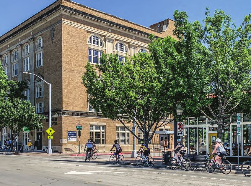
Near Southside District (27)Storefronts along 8th Avenue
The principles support active streets with ground level
uses that are oriented to public sidewalks.
Parking lot located to the side of a historic
building on S. Main St.
DEVELOPMENT STANDARDS AND GUIDELINES
Parking lots located behind or to the side of buildings are
consistent with the district’s urban character.
Historic Mehl Building on Magnolia Avenue
Historically significant buildings help define the district and
should be incorporated into new projects.
(28) Near Southside District5.A. Intent and Principles (cont.)
SITES AND BUILDINGS
1. Design sites and buildings, and the lower floors of buildings in particular, so that they
promote pedestrian activity and provide an active, human-scale, continuous,
pedestrian-oriented street edge along public sidewalks.
2. Design buildings and sites that provide visual variety and enhance the Near Southside’s
and the Hemphill Corridor’s overall sense of place.
3. Build distinctive neighborhoods that enhance local identity.
4. Promote building scale that enhances the public realm, and promote new buildings that
complement the scale of neighboring structures, particularly adjacent historic buildings.
5. Locate and design surface parking lots, individual garages, and large parking garages so
as to reduce their visual impact and/or to create public amenities (e.g., through aesthetic or
environmental features).
6. Design and orient buildings on Magnolia, Park Place, West Rosedale, South Main,
Pennsylvania, 8th Avenue, and Vickery so as to support the streets’ roles as the Near
Southside’s primary pedestrian-oriented commercial districts.
7. Encourage the use of durable, attractive materials that promote sustainability and the
reuse of buildings.
8. Design buildings that reflect the time in which the structures are built, as the district’s most
DEVELOPMENT STANDARDS AND GUIDELINES
treasured historic buildings do.
9. Without dictating architectural style, encourage building facade designs that contribute to
an attractive streetscape and skyline.
10. Encourage all civic and publicly sponsored buildings to be of exceptional design quality.
11. Design buildings and sites so as to minimize negative impacts on air and water quality and
to promote a sustainable natural environment.
Near Southside District (29)5.B. Streets and Other Public Spaces
1. Street Standards
a. Main Streets
DEVELOPMENT STANDARDS AND GUIDELINES
NOTES:
1) The City’s Traffic Engineer is authorized to approve modifications to cross-section dimensions in response to
site-specific constraints.
(30) Near Southside Districta. Main Streets (cont.)
DEVELOPMENT STANDARDS AND GUIDELINES
NOTES:
1) The City’s Traffic Engineer is authorized to approve modifications to cross-section dimensions in response to
site-specific constraints.
Near Southside District (31)5.B. Streets and Other Public Spaces (cont.)
1. Street Standards (cont.)
b. Mixed-Use Streets
DEVELOPMENT STANDARDS AND GUIDELINES
NOTES:
1) The City’s Traffic Engineer is authorized to approve modifications to cross-section dimensions in response to
site-specific constraints.
(32) Near Southside Districtb. Mixed-Use Streets (cont.)
DEVELOPMENT STANDARDS AND GUIDELINES
NOTES:
1) The City’s Traffic Engineer is authorized to approve modifications to cross-section dimensions in response to
site-specific constraints.
Near Southside District (33)5.B. Streets and Other Public Spaces (cont.)
1. Street Standards (cont.)
c. Commercial Streets
DEVELOPMENTSTANDARDSANDGUIDELINES
NOTES:
1) The City’s Traffic Engineer is authorized to approve modifications to cross-section dimensions in response to
site-specific constraints.
(34) Near Southside Districtd. Alleys
1. Alleys shall conform to all standards contained in the Subdivision Ordinance,
Traffic Design Manual and Water & Sewer Design Manual.
2. Property owners along Hemphill Street are encouraged to work with neighbor-
hoods and adjacent property owners for the use, paving, and beautification of
existing alleys.
DEVELOPMENTSTANDARDSANDGUIDELINES
Near Southside District (35)5.B. Streets and Other Public Spaces (cont.)
2. Public Roadsides
a. Roadside Design Options
1. Dual Planting 2. Wide Planting 3. Narrow Planting 4. Sidewalk
Strips Strip Strip Planter
Roadside Width - Total width of pedestrian way and street tree/furniture zone (see 5.B.2.b for minimums).
20+ feet 13-15 feet 10-15 feet 10-20 feet
Pedestrian Way
NS 5 ft. minimum 5 ft. minimum 5-10 ft. minimum 5-10 ft. minimum
Paved (6 ft. if adjacent (6 ft. if adjacent (6 ft. if adjacent
Walkway to angled parking) to angled parking) to angled parking)
Hemphill 7 ft. for 7 ft. for
Corridor commercial, 5 ft. commercial, 5 ft. 7-10 ft. minimum 5-10 ft. minimum
Paved for residential blks for residential blks
Walkway
Between planting Along property Along property Along property
strips line line, or line, or
along planting along planting
DEVELOPMENTSTANDARDSANDGUIDELINES
Walkway strip if sidewalk strip if sidewalk
location seating or display seating or display
is located along is located along
property line. property line.
Street Tree/Furniture Zone - Located along the curb; includes street trees, pedestrian lights, and other elements.
Planter Min 5.5 ft. wide Min 8 ft. wide Min 5.5 ft. wide Min 5 ft. x 5 ft
(each) tree well
Tree 25-35 ft
Spacing (Must be min. 10 ft 15-35 ft 15-35 ft 15-35 ft
5.B.3.a from bldg.)
Ped Light 60 ft 60 ft 60 ft 60 ft
Spacing maximum maximum maximum maximum
5.B.3.c
Other -Irrigated -Irrigated -Irrigated -Bike racks
elements groundcover groundcover groundcover -Trash bins
5.B.3.d -Fire hydrants -Fire hydrants -Bike racks -Benches
-Trash bins -Wayfinding signs
-Benches -Sidewalk tables
-Wayfinding signs and displays
-Sidewalk tables
and displays
(36) Near Southside District2. Public Roadsides (cont.)
b. Projects subject to roadside standards – All new construction
projects, as well as major renovations in which the:
1. Gross floor area to be renovated exceeds 10,000 sf, and
2. Value of the renovation exceeds the appraised value (per Tarrant
Appraisal District records) of the property’s improvements prior to
renovation.
c. Minimum roadside widths for new construction projects – To accommodate the
required minimum widths for street tree/furniture zones and pedestrian ways,
minimum roadside width standards apply. These standards apply regardless of the
available public right-of-way. Where insufficient right-of-way exists, the pedestrian
way shall extend onto private property, with a public sidewalk easement provided.
The roadside shall be measured from the back of the curb to the outside edge of the
pedestrian way (closest to the building façade).
1. “Commercial” and “Mixed-Use” streets – 10.5 ft. minimum
2. “Main” streets – 15 ft. minimum
3. Roadside Elements
a. Street trees
1. Developments must conform to the tree preservation standards set forth
in Section 5.G.1. Canopy of street trees can be applied towards mitigation
requirements. The provisions below also apply.
DEVELOPMENTSTANDARDSANDGUIDELINES
2. Public and private development shall provide shade trees within the street
tree/furniture zone.
3. Street trees shall be a minimum of three (3) inch caliper and placed 15-35
feet apart on center, depending on the trees’ size at maturity.* (See the list
at right for spacing standards, and the spacing note on the bottom of p.
33.) Where necessary, spacing exceptions may be made to accommodate
mature trees, curb cuts, fire hydrants and other infrastructure elements.
4. To maximize survival rates, trees shall be planted to ensure proper
drainage and shall be irrigated.
5. Low maintenance tree planter systems, such as pervious pavers or planting
strips, shall be used. Tree grates collect trash and damage trees and are
not a low maintenance system.
6. Street trees shall be pruned to allow 8-foot clearance for pedestrians.
7. Trees shall be planted at the time of development, although the planting
schedule may be extended to allow planting during the fall/winter season.
Near Southside District (37)5.B. Streets and Other Public Spaces
3. Roadside Elements (cont.)
a. Street trees (cont.)
Best Good
Small Canopy (Min. 15’ spacing) Medium Canopy (Min. 25’ spacing)
Redbud Ginkgo
Mexican Plum
Eve’s Necklace Large Canopy (Min. 35’ spacing)
Pecan
Medium Canopy (Min. 25’ spacing)
Caddo Maple Prohibited
Bald Cypress Hackberry Willow
Large Canopy (Min. 35’ spacing) Sycamore Bradford Pear
Texas Red Oak Silver Maple Chinese Pistache
Shumard Oak Mulberry
Live Oak Siberian Elm
Durand Oak Mimosa
Lacebark Elm Arizona Ash
Cedar Elm Cottonwood
b. Pedestian Way
1.The pedestrian way shall have
walkways a minimum width of 5 feet and
shall comply with ADA and Texas
Accessibility Standards.
Exemption: Minor renovation projects on
DEVELOPMENTSTANDARDSANDGUIDELINES
properties with existing 4 ft. sidewalks.
2. Paving materials shall be attractive and
easy to maintain. Appropriate materials:
• Concrete
• Pervious concrete
• Masonry pavers over concrete
base
• Similarly durable materials that
meet City standards
Street tree/furniture Pedestrian Way
zone (Clear walkway,
(Trees, Lights, Awnings and other
Bike Racks,Tables) shade elements)
(38) Near Southside District3. Roadside Elements (cont.)
c. Pedestrian Lights
1. New public and private development shall provide pedestrian lights within the roadside’s
street tree/furniture zone, except in NS-T4HN.
• Any new structure larger of 10,000 sq. ft. in NS-T4, NS-T4H shall have street
lighting requirement under NS-T4 (installation of pedestrian street lighting shall
be required)
• NS-T4H & NS-T4HN require non-flood lighting sufficient to cover pedestrian
areas in front of property or business, but not beyond the curb, and per City code
may not be more than 3,000 kelvin.
• New or rehabilitated structures may not need to install pedestrian street
lighting as outlined in Section 5,B, 3,c; however, lighting for pedestrian areas
in and around property is required. Lighting must blend into the architectural
elements of the structure. These lighting elements shall be approved by either
UDC, Planning Department and if necessary Landmarks Commission.
• Any new lighting to meet this requirement shall not be in the form of flood
lighting, intermediate or strobe lighting.
2. Pedestrian lights shall be located
approximately at the midpoint between two
trees and spaced a maximum of 60 feet
apart.* (See note below.) Where necessary,
spacing exceptions may be made to
accommodate mature trees, curb cuts, fire
hydrants and other infrastructure elements.
DEVELOPMENTSTANDARDSANDGUIDELINES
3. Guidelines
• Continuity of lighting style throughout a
neighborhood is encouraged.
• Lights should be durable and easy to
maintain or replace.
Since its inception, Fort Worth South, Inc. has
worked with developers to install pedestrian
lights as part of new construction projects,
including this development along College
Avenue. The roadside standards in this
section promote the installation of lights
throughout the Near Southside.
Near Southside District (39)5.B. Streets and Other Public Spaces
3. Roadside elements (cont.)
d. Guidelines for other roadside elements
1. Bike racks, trash bins, and seating should be incorporated into streetscape designs
on “Main Streets” and other streets with high levels of pedestrian activity. Continuity of
style throughout a neighborhood is encouraged. These elements should be durable,
cost effective, and easy to maintain.
2. Transit shelters should:
• Be located in areas with a high level of pedestrian activity, but shall not
impede pedestrian traffic or wheelchair circulation.
• Provide comfortable seating and should not use the standard,
stand-alone advertising benches seen at many bus stops.
• Where feasible, incorporate other streetscape elements, such as
water fountains, newspaper boxes, trash bins, and/or signage.
• Reflect design excellence and should be designed as more
than simple utilitarian fixtures. Creative and timeless designs that
complement other streetscape furnishings are encouraged.
• Be constructed of durable, attractive, and sustainable materials that
are easy to maintain.
* If no pedestrian lights or street trees exist on the project’s block face, measure from the
end of the block to determine spacing. (For trees: begin 40 feet from curb intersection to
accommodate public open space easement requirement.) If trees or lights exist, measure
from existing trees or lights.
DEVELOPMENTSTANDARDSANDGUIDELINES
Bike racks that are easy to recognize,
attractive, and simple to use help make the
Near Southside bike-friendly, providing
convenience and security.
(40) Near Southside District5.B. Streets and Other Public Spaces (cont.)
4. Public Parks and Plazas
a. Park Dedication Policy – The City’s park dedication policy has been updated, revised and
effective March 1, 2019. If the proposed residential development falls within the Central City, the
developer shall pay a Central City Flat Fee per each additional residential dwelling unit in lieu of a
land dedication and associated fees. Fees will be assessed at the time of building permitting. Fees
must be paid before a building permit will be issued. If mutually agreed between the Developer
and the Park & Recreation Department, credits against this fee may be granted when there is
public or private parkland proposed for the site and/or when park facility development is proposed.
Agreements concerning parkland classification and acceptability, and determinations of allowable
fee credits, must be formalized prior to release of the first building permit. The Central City Flat
Fee is based on current costs for land acquisition and park development and may be adjusted
administratively on an annual basis up to the annual amount of change in the Consumer Price
Index (CPI). Any fee increase or decrease greater than the CPI shall require the approval of the
City Council. The Central City Flat Fee shall be:
Central City Flat Fee
Per Each Additional
Calendar Year Residential Dwelling Unit
2018 $500.00
2019 $660.00
2020 $820.00
2021 $980.00
2022 $1,140.00
DEVELOPMENTSTANDARDSANDGUIDELINES
2023 $1,300.00
b. Plazas – Plazas are urban public spaces that are more formal than parks and have
a higher degree of hard surfaces and pedestrian traffic. Guideline for impervious
surface area: Maximum 40 percent.
c. Parks – Parks are open spaces that have less hard surface and pedestrian traffic
than plazas. Parks typically include both active and passive recreation areas. Guideline
for impervious surface area: Maximum 20 percent.
d. Hours – Publicly and privately maintained public spaces shall be publicly accessible
during daylight hours. Access may be limited at other times.
Near Southside District (41)5.B. Streets and Other Public Spaces (cont.)
4. Public Parks and Plazas (cont.)
e. Design guidelines – Publicly and privately developed public spaces should
conform to the following guidelines, to the extent possible.
1. Design all public spaces other than large recreational parks to be human-
scale and visually interesting.
2. Locate and design public spaces so that they are clearly visible and easily
accessible.
3. Incorporate space-defining and active edges – such as multi-story façades
with ground floor restaurants – but avoid blank walls. Cafés and shops that
attract pedestrians are ideal edge uses.
4. Plan for prevailing sun angles and climatic conditions.
5. Avoid locating public spaces on corner lots. Corners are better suited for
buildings that establish a strong urban street edge.
6. Avoid sunken plazas and architectural bench arrangements; these often fail
to promote use.
7. Provide flexible space for programmed uses, but design such spaces so that
they do not appear barren when there is no programming.
8. Incorporate features that attract users, such as fountains, public display
areas, or interactive sculpture.
9. Incorporate landscaping to provide natural shade and/or to soften hardscape
areas.
DEVELOPMENTSTANDARDSANDGUIDELINES
The standards and guidelines encourage
a variety of public spaces on the Near
Southside, ranging from the type of active
urban plaza shown above to more passive
and heavily landscaped neighborhood
parks.
John Hancock Plaza, Chicago
Source: Project for Public Spaces
(42) Near Southside District5.B. Streets and Other Public Spaces (cont.)
5. Public Art Guidelines
a. Public art in private projects – Where feasible, developers are encouraged to integrate
art into the design process for buildings and public spaces.
b. Public art in public projects – Public agencies are encouraged to integrate art in
the design of all publicly visible infrastructure, including retaining walls and public spaces.
c. Fort Worth Art Commission assistance – The Fort Worth Art Commission may assist
with identifying appropriate artists and/or advise on selection processes for projects.
Eric McGehearty’s The firefighter boots sculpture at Fire Station
United We Stand #8 was funded through the City’s public art
program. In addition to art that is integrated
at Fire Station #8
into City projects, privately sponsored public art
can greatly enhance a development project’s
appeal and value.
DEVELOPMENTSTANDARDSANDGUIDELINES
Near Southside District (43)5.C. Building Location and Orientation
1. Base Setback Standards
New buildings shall be located in relation to the boundaries of their lots according to the
setback standards listed below and depicted to the right.
FRONT SETBACK
0 ft. min., 20 ft. max. except as described in Section 5.C.2. below.
SIDE SETBACK
0 ft. min., except as described in Section 5.C.2.e. below.
REAR SETBACK
3 ft. min.
CORNER SETBACK
5’ x 5’ dedication when required by Section 5.C.2.f. below.
General yard development standards: Development shall be exempt from Chapter 6,
Article 1, Sections 6.101B, 6.101E, and 6.101G of the zoning ordinance.
2. Contextual Setback Standards
a. Buildings fronting designated “Main” streets – Front setback is 0 ft. min. and 10 ft.
max. (Street classification maps shown in Section 4.C.)
b. Buildings fronting public spaces – Buildings that front pocket parks, plazas, or other
public spaces may exceed the maximum front setback.
c. Oleander Walk T4-N zone – Front setback is 5 ft. min. and 10 ft. max. along Oleander
Walk; 0 ft. min. and 10 ft. max. along other streets.
DEVELOPMENTSTANDARDSANDGUIDELINES
SETBACKS: SETBACKS:
PARTIAL BLOCKFACE CONDITIONS FULL BLOCKFACE CONDITIONS
(44) Near Southside DistrictSETBACKS:
INTERIOR BUILDINGS
d. Hemphill south of Alley Avenue - Front setback is 5’ minimum, unless adjacent to a
historic building.
• Lots adjacent to historic buildings - Match front setback for historic buildings
(designated or eligible as noted in Section 4.B.)
• If 50% or more of block face is established with historically eligible
structures, the setback shall match the existing setback.
• 45 degree tiered setback on blocks where 50% rule is not established.
e. “On-street” parking or public walkways located on private property – If angled,
perpendicular, or parallel parking is located on private property but functions the same
DEVELOPMENTSTANDARDSANDGUIDELINES
as on-street parking, the front setback is measured from the edge of the public walkway.
Similarly, if a required public walkway (see Section 5.B.2) encroaches onto private
property, the setback is measured from the walkway edge as shown in diagrams to right.
f. Side yards adjacent to existing buildings – When an abutting property with an
existing building has windows facing to the side, any new building shall provide at least
10 feet of separation.
g. Corner buildings – For corner buildings at street and alley intersections that do not
include all-way stop signs or traffic signals, a triangular dedication measuring 5’ by 5’ is
required by the subdivision ordinance. The triangle shall be measured from the property
line and clear of visibility obstructions.
h. Interior buildings – Interior buildings may be constructed if the project also includes
frontage buildings that are oriented to public streets. Specifically, buildings may exceed
the setback if at least 60 percent of the public street frontage on each block face within
the development contains buildings within the maximum setback of 20 ft. The frontage
percentage is reduced to 50 percent for institutional or industrial campuses in “I” zones.
i. Lots adjacent to historic buildings - Match front setback for historic buildings
(designated or eligible as noted in Section 4.B.)
Near Southside District (45)You can also read