Greater Darwin Region
Land Use Plan
Towards 2030

Consultation Paper
←
→
Page content transcription
If your browser does not render page correctly, please read the page content below
Greater Darwin Region Land Use Plan Towards 2030 Consultation Paper
Published by the Department of Lands and Planning

© Northern Territory Government 2011.

Apart from any use permitted under the Australian Copyright Act no part
of this document may be reproduced without written permission from the
Northern Territory Government through the Department of the Chief Minister.

ISBN 978-1-921728-05-1

Enquiries should be made to:
Department of Lands and Planning
GPO Box 1680
Darwin NT 0801
www.growingnt.nt.gov.au

Throughout this document the term Indigenous is used to refer to both
Aboriginal and Torres Strait Islander people.

NAME OF SECTION GREATER DARWIN REGION LAND USE PLAN
Greater Darwin Region
Land Use Plan
Towards 2030

Consultation Paper

CONSULTATION
The Greater Darwin Region Land Use Plan – Towards 2030 Consultation Paper
is placed on public exhibition to seek community input and support.
Minister for Lands and Planning
    A message from the Hon Gerry McCarthy MLA
                                         The Greater Darwin Region is unlike anywhere
                                         else in the country, and the Territory Government
                                         is planning for its future with the Greater Darwin
                                         Region Land Use Plan – Towards 2030.
                                         The region’s economy and population are growing.

                                         Young Territorians are taking advantage of the job opportunities on offer and
                                         raising their families here, more people are moving from interstate to enjoy our
                                         lifestyle, and older Territorians are choosing to retire here.

                                         The economic future is bright, supported by Government’s record infrastructure
                                         program, and its commitment to securing major projects like INPEX, a Marine
                                         Supply Base and new mines.

                                         The Territory 2030 strategic plan sets a roadmap for the future, including
                                         targets for affordable housing and the community’s desire for new and
                                         sustainable urban design.

                                         The Greater Darwin Region Land Use Plan – Towards 2030 provides the
                                         framework for reaching these targets, using sound economic forecasts to deliver
                                         sustainable residential development, drive economic growth and maintain our
                                         tropical lifestyle.

                                         It outlines strategies to deliver a range of sustainable residential options, including
                                         the release of new land, infill development in existing areas and rural lifestyles.

                                         It forecasts the release and development of commercial and industrial land to
                                         support and grow the region’s economic potential.

                                         At the heart of the Land Use Plan is the recognition by the Government and the
                                         community of the importance of Darwin Harbour and the region’s waterways
                                         and environs.

                                         The release of this consultation paper is a key step in the finalisation of a Land
                                         Use Plan that will guide the development of the region to 2025.

                                         I encourage all Territorians to have their say so that Government and the
                                         community, working together, can deliver the best outcome for the region.

                                         HON GERRY McCARTHY MLA

2   MINISTER FOR LANDS AND PLANNING’S MESSAGE GREATER DARWIN REGION LAND USE PLAN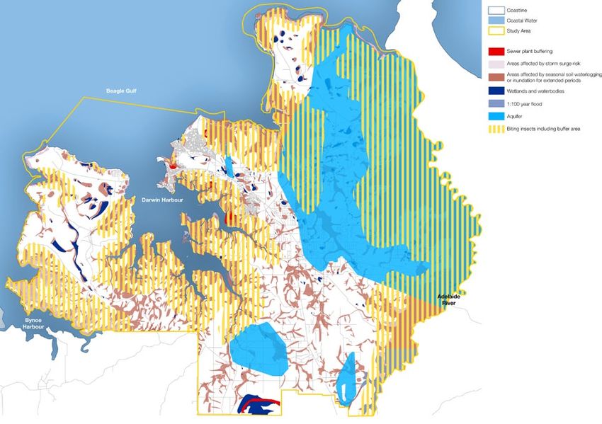
TOWARDS 2030 OVERVIEW 3
4 CONTENTS GREATER DARWIN REGION LAND USE PLAN
Contents

INTRODUCTION      		 Introduction                                                                6
                  		 Our unique Region                                                           7
                  		 Shaping the future for Greater Darwin Region                                8

THE LAND USE    		      The Land Use Plan in Overview                                           10
PLAN IN OVERVIEW		      Planning for growth                                                     11
                		      Delivering ‘Territory 2030’                                             12
                		      The Greater Darwin Region Land Use Plan – Towards 2030                  15
                		      Planning for growth                                                     20
                		      Shaping the future                                                      20

SECTION 01      		      The Land Use Plan’s role and function                                   22
                		      What is a Regional Land Use Plan? Why do we need one?                   23
THE LAND USE
PLAN’S ROLE AND 		      The role of the Greater Darwin Region Land Use Plan – Towards 2030      24
FUNCTION        		      The Land Use Plan’s relationship to key Territory government policies   25
                		      Better urban design                                                     26

SECTION 02        		    Context                                                                 28
                  		    A rapidly growing population                                            29
CONTEXT
                  		    Population growth scenarios towards 2030                                30
                  		    A changing context                                                      31
                  		    The Region’s economic profile 2011                                      32
                  		    A strategic approach to the future                                      33
                  		    Strategic directions for the Region                                     34

SECTION 03        		    Policies and actions                                                    36
                  		    Targets of the Land Use Plan                                            37
POLICIES AND
ACTIONS           		    Residential growth                                                      38
                  		    Land for industry                                                       47
                  		    Retail and bulky goods land supply                                      50
                  		    Commercial floor space                                                  53
                  		    Infrastructure planning                                                 54
                  		    Power, water and sewerage infrastructure                                55
                  		    Social infrastructure                                                   57
                  		    Funding infrastructure                                                  58
                  		    Climate change                                                          59
                  		    Natural heritage and biodiversity                                       60
                  		    A balanced housing market in the Region                                 61
                  		    Conclusion                                                              62

SECTION 04     		 Implementation                                                                64
IMPLEMENTATION 		 Northern Territory Government co–ordination                                   66
		             		 Partnering with local government                                              66
               		 Land supply, monitoring and review                                            67
               		 Review of planning instruments and other actions                              68

APPENDICES        		    Appendix   A   Council of Australian Governments (COAG) criteria        72
                  		    Appendix   B   Industrial Land Supply by Area                           73
                  		    Appendix   C   Investment in infrastructure forecast                    74
                  		    Appendix   D   Background Data                                          78

                  		    Glossary of terms                                                       81

                                                    GREATER DARWIN REGION LAND USE PLAN     CONTENTS   5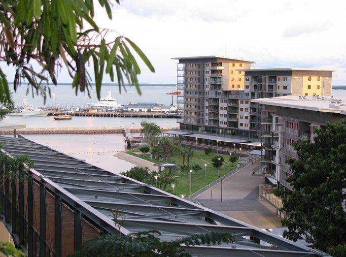
Introduction
The Greater Darwin Region Land Use Plan –
Towards 2030 Consultation Paper takes Greater
Darwin on a pathway to planned growth.
Our Unique Region

The Greater Darwin Region offers a            to Darwin in the 1990s all brought a      The Government is delivering a record
lifestyle unlike any other in Australia.      boost in population and new economic      $1.8 billion infrastructure program and
It is set apart by its monsoonal              opportunities for local industry.         supporting the release of industrial land.
tropical climate, its remoteness from
other state capitals, and its competitive     The completion of the Alice Springs       Significant Government measures are
proximity to the thriving cities of           to Darwin railway in 2003 linked the      also in place to meet demand for land
South East Asia.                              Territory to the nation’s rail network,   and housing options including:
                                              delivering new freight opportunities.     >> allocating 15% of all residential
The Region is centred around the                                                           land release to affordable and
beautiful Darwin Harbour and its              Arguably one of the most significant
                                                                                           social housing;
catchment areas, where ecosystems             economic drivers in the Territory’s
                                              history was the commissioning of the      >> creation of an Affordable Rental
are the centrepiece of our enviable
                                              $1.75 billion ConocoPhillips LNG plant       Housing Company;
lifestyle.
                                              at Wickham Point in 2006.                 >> the development of Palmerston
The Region has, for thousands of                                                           East – Johnston, Bellamack, Zuccoli
years, been the home to the Larrakia          The construction of the plant                and Mitchell;
people. From the time of the first            generated thousands of jobs and
                                                                                        >> supporting private residential
European settlement at Fort Hill              delivered a new industry to the
                                                                                           developments such as Muirhead
in 1869, the Larrakia have been,              Territory, confirming Darwin as an
                                                                                           and the Palmerston Charles Darwin
and remain, an integral part of               international gas hub.
                                                                                           University Campus; and
our community.
                                              In 2009, the Territory Government         >> planning for the new city of Weddell.
The Region retains spiritual and              reached an agreement with the Northern
                                              Land Council and Traditional Owners       This work is not being done at the
cultural significance for the Larrakia
                                              regarding the Kenbi Land Claim. The       expense of the environment. The
and other Indigenous groups. The
                                              agreement opened Cox Peninsula for        Government has established a Darwin
term “Larrakia” refers to the language,
                                              potential development by, and for the     Harbour Management Strategy,
the land and the people who remain
                                              benefit of, the Larrakia people.          protected Glyde Point from heavy
the traditional custodians of the land
                                                                                        industry, and rejected damming the
and waters of the Greater Darwin
                                              The Greater Darwin Region is              Elizabeth River. Government has also
Region.
                                              experiencing a period of high             moved to introduce 5-star energy
More than 100 cultural backgrounds            economic growth that is forecast to       ratings for houses and 3.5 star ratings
are represented in the Territory              continue, fuelled by expansion of the     for units.
community today.                              defence, mining, gas and energy and
                                              service sectors.                          The Territory Government wants
Since self-government the Territory                                                     to harness economic and growth
has experienced significant growth            The Territory Government is pursuing      opportunities for the future benefit
and change, usually associated with           major projects that will sustain the      of Territorians, while protecting the
the onset of major projects.                  economy into the future, including the    environment and Territory lifestyle.
                                              INPEX Ichthys gas project, and the
The military build up in World War II,        development of a Marine Supply Base       The Greater Darwin Region Land Use
rebuilding after the devastation of Cyclone   and a Defence Support Hub.                Plan – Towards 2030 Consultation
Tracy, and the significant relocation                                                   Paper (the Land Use Plan) will be a
of Army personnel and equipment                                                         central plank of Government achieving
                                                                                        this aim.

                                                                                                  TOWARDS 2030     INTRODUCTION      7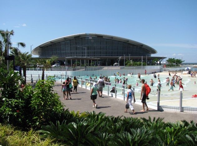
Shaping the Future for the Greater Darwin Region

    The Territory has the challenge and      Vacant and underutilised land               At the centre of the Territory
    opportunity to develop the Region for    will be developed, and targeted             Government’s land release program is
    the 21st century, with a balance of      redevelopment will take place on            a commitment to protecting the health
    economic and population growth and       Multiple Dwelling and Medium                of the Harbour, including:
    social and environmental benefit. The    Residential zoned land.                     >> maintaining a healthy environment;
    Land Use Plan includes:
                                             A wide variety of housing options           >> supporting recreational use and
    >> continuing the evolution of the                                                      enjoyment of the environment;
                                             will be developed, including town
       Greater Darwin Region into a
                                             houses, duplexes and triplexes to meet      >> ensuring development is
       thriving, multicultural and modern
                                             increased demand from single-person            implemented in an ecologically
       capital city that is the centre of
                                             homes and older Territorians.                  sustainable manner;
       administration, tourism and retail;
                                                                                         >> protecting cultural values and
    >> consolidating Palmerston as a city    Palmerston’s development as a city of
                                                                                            heritage; and
       of choice for young families;         choice for families is being supported
                                             by the development of new suburbs in        >> fostering community awareness
    >> developing distinct rural villages
                                             Palmerston East, and investment in key         and stewardship of the Darwin
       within the Litchfield area centring
                                             community and social infrastructure            Harbour Region.
       around a rural lifestyle;
                                             such as schools, sporting, religious and
    >> more inter-connected, lively,                                                     The Land Use Plan has sustainability as
                                             recreational facilities.
       urban and rural communities with                                                  a core focus, balancing economic and
       distinct character;                   The Palmerston CBD will continue to         social growth with environmental needs.
    >> providing land to meet present and    grow into a modern city centre with
       future housing needs, delivering      residential development, retail, offices,
       long term balance to the housing      an international hotel and residential
       market and promoting affordability;   apartments.
    >> providing suitable land for our
                                             The rural areas of Litchfield will
       industries to grow;
                                             develop around villages with a district
    >> creating a new tropical,              centre surrounded by larger areas for
       sustainable and liveable city of      rural living. This will see block sizes
       Weddell to accommodate the            reducing in and around the heart of the
       growth in the Region;                 villages but retaining the larger rural
    >> continuing to protect Darwin          residential lots outside of those areas.
       Harbour and its catchments; and
    >> supporting the future potential
       private development of the
       northern coast of Cox Peninsula
       adjacent to Darwin.

8   INTRODUCTION    GREATER DARWIN REGION LAND USE PLAN
The Territory has the challenge
and opportunity to develop the
Region for the 21st century.
TOWARDS 2030 OVERVIEW 9The Land Use Plan in Overview The vision for the Region is for a series of more compact, interconnected, lively urban and rural communities.
Planning for growth

The Greater Darwin Region Land Use        The multicultural city of Darwin is          Climate change is bringing more
Plan – Towards 2030 Consultation          the Region’s centre of administration,       extreme weather patterns which will
Paper (the Land Use Plan) supports        tourism and retail. Palmerston is the        impact on our cities and on how we use
the Territory Government’s aim to         city of choice for young families.           our resources and design our suburbs.
build a prosperous and sustainable        The Litchfield area offers a set of
future for the Territory.                 distinct villages for work and leisure       It is essential for Government and
                                          opportunities, while retaining the           the community to understand how
The Land Use Plan provides a              surrounding rural lifestyle.                 growth is likely to affect the Region,
roadmap for growth in the Darwin,                                                      and shape the planning, design
Palmerston and Litchfield areas, and      The Greater Darwin Region is an              and building of our cities, towns
seeks input from Territorians on its      important education centre and Defence       and neighbourhoods to make them
strategies and initiatives for a strong   centre. It is a cultural hub that reflects   sustainable and prosperous.
future for the Region.                    the thousands of years of occupation
                                          by Indigenous Australians and the            The Land Use Plan will focus
More people are moving to the             more recent waves of settlement.             planning for the Region toward
Territory to enjoy the opportunities                                                   2030, by assessing and responding
and lifestyle on offer. Access            The average age of the Region’s              to the challenges and opportunities
Economics forecasts average annual        population is 32 years.                      before us to deliver a sustainable,
population growth in the Territory                                                     prosperous future.
of 1.8% over the next five years,         Younger people are staying to enjoy
compared to a national average of         the broader employment opportunities         Consultation with the community and
1.6%. Palmerston is one of the fastest    and lifestyle on offer. Older people are     feedback from Territorians about this
growing cities in the country.            choosing to retire here, and families        Land Use Plan is important and will
                                          are evolving into smaller units.             inform the development of the final
It is expected an extra 53,000 to                                                      Land Use Plan.
70,000 people will call the Greater       There is a need to respond to the
Darwin Region home by 2025.               particular housing aspirations and
                                          needs of our diverse population.

                                                                                                     TOWARDS 2030    OVERVIEW 11
Delivering ‘Territory 2030’
The Territory 2030 Strategic Plan Territory 2030 sets targets to reduce The Greater Darwin Region Land
(Territory 2030) was developed in use of water and electricity, cut Use Plan provides a framework for
consultation with the community greenhouse gas emissions, reduce delivering on these Territory
and provides a road map for the reliance on private motor vehicles 2030 targets.
Territory’s future. and reduce the amount of waste we
produce. It says that we will protect It delivers a range of population
Territory 2030 sets targets for affordable the unique natural environment forecasts, and responds to the challenges
housing, and outlines the desire for new centring on Darwin Harbour. of residential and industrial land supply,
and sustainable urban design. It seeks housing demand, sustainable urban
an enriched society and community It envisages a community that design and energy efficiency.
life for Darwin’s people and a strong successfully balances growth
and stable economy. and the environment, with more It maps the need for long term
community-centred urban design that infrastructure planning for roads,
It foreshadows the growth of allows Territorians to connect with power, water, sewerage and
the Greater Darwin Region as their location, climate, people and telecommunications.
an international hub for exports, sustainability.
education, health services, tourism and The Land Use Plan focuses on
operations and maintenance. economic and social development,
balanced with protecting the
Territory’s natural resources in a
sustainable way.
12 OVERVIEW GREATER DARWIN REGION LAND USE PLANTerritory 2030 sets targets
for affordable housing, and
outlines the desire for new and
sustainable urban design.
TOWARDS 2030 OVERVIEW 1320km
Landscape
10
Elements
Natural
5
0
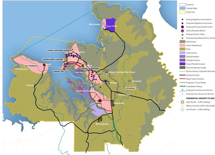
14 OVERVIEW GREATER DARWIN REGION LAND USE PLANThe Greater Darwin Region
Land Use Plan – Towards 2030
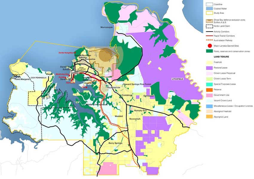
The Greater Darwin Region Land Airports, Department of Defence The Land Use Plan also foreshadows
Use Plan encompasses an area of installations, and land identified for establishment of Weddell as the next
approximately 419,500 hectares. It strategic industry and urban and rural city in the Region. Work has begun on
centres on Darwin Harbour and communities are also included. planning for this tropical, liveable and
reaches to the Beagle Gulf in the sustainable city with input from local,
North, Bynoe Harbour in the West, The Land Use Plan has been national and international experts.
and Adelaide River in the East, and developed by mapping these natural
20 kilometres inland from Darwin elements and significant sites to The range of residential development
Harbour in the South. identify priority areas for expanding across the Darwin, Palmerston
existing communities, developing and Litchfield Region will provide
The Region covers a wide spectrum new population centres and optimum housing choices for Territorians in the
of communities and environments, transport corridors, and areas to CBD, suburbs and rural areas while
ranging from the Darwin CBD on the support industrial growth. retaining the Territory lifestyle.
edge of the beautiful Darwin Harbour
to the Malacca swamp on the Adelaide It provides the framework for Darwin to Eight precincts within the Region are
River, one of the Territory’s wildest continue as the Region’s administration, identified for potential growth to 2025:
natural habitats. tourism and retail centre. It will be
linked by a series of interconnected Darwin City Centre; Darwin Inner
The natural elements include areas urban and rural communities each Suburbs; Darwin Northern Suburbs;
affected by water logging and with their own distinct character and Winnellie/Berrimah; Palmerston;
seasonal inundation, storm surge, Territory lifestyles. Weddell; Litchfield; Cox Peninsula.
natural wetlands, steeply sloping land,
aquifers, soil and vegetation types, It provides the framework for
and biting insect breeding areas. Palmerston to continue to grow as
the city of choice for families. The
It covers recognised Larrakia sacred Litchfield area is planned to support a
sites, other cultural and heritage sites, network of village centres.
and parks and conservation reserves.
TOWARDS 2030 OVERVIEW 1520km
Land Uses
10
Priority
5
0
16 OVERVIEW GREATER DARWIN REGION LAND USE PLANThis is a snapshot of places that will contribute to accommodating residential and commercial growth.
Area Contribution to growth
Targeted infill and redevelopment will accommodate
growth. Frances Bay, waterfront and key sites within
Darwin City Centre the CBD are identified as places where higher
density development can occur sustainably.
The existing CBD,
Bayview and associated The CBD has planning that allows building heights
inner suburbs to 90 metres above ground level.
Darwin City –
Inner Suburbs There is potential for growth through continuing
Cullen Bay, Fannie Bay, redevelopment, infill and some densification of
Stuart Park and medium density housing.
The Gardens
Development will occur by increased density in the
area surrounding the Casuarina Shopping Centre
Darwin City – and commercial area.
Northern Suburbs There will be a mixture of Greenfield land releases,
Including Casuarina such as Muirhead, and infill development.
Redevelopment of land for medium density housing
will also be encouraged.
Development and growth in this area will be a
mixed use development of commercial, industrial
Winnellie/ Berrimah
and residential.
Berrimah Farm, Berrimah
Proposed redevelopment of Berrimah Farm and
Prison Land and
Berrimah Prison are examples of infill sites that
The Narrows.
could produce well located mixed residential and
commercial development.
Residential development will continue in
Palmerston, including the Palmerston East suburbs
of Bellamack, Johnston, Zuccoli and Mitchell, and
Palmerston the Charles Darwin University campus site.
The CBD will also be energised with targeted projects
including the so-called ‘Super Block’. Residential
development in the CBD will be promoted.
TOWARDS 2030 OVERVIEW 17Area Contribution to growth
The new City of Weddell on Middle Arm Peninsula
south of the Elizabeth River and associated future
development areas around Noonamah will be the
Weddell focus of new land release.
Weddell is a Greenfield development site and is
undergoing detailed master planning as a tropical,
sustainable and liveable city, and a model for the future.
Development will occur in and around the identified
Litchfield
rural villages district centres, namely Girraween,
Existing and planned Pine Forest, Coolalinga, Fred’s Pass, Virginia,
development areas Humpty Doo, Noonamah and Berry Springs.
within the Litchfield local
This will be mainly on infill sites with increased
government area.
density in the heart of the centres.
This Greenfield site could be developed for urban
residential and supporting community and commercial
Cox Peninsula uses subject to the provision of essential services.
Land at the northern end Pending the settlement of the Kenbi land claim,
of Cox Peninsula. the Cox Peninsula could be opened for private
development for up to 10,000 people over the life
of the Land Use Plan.
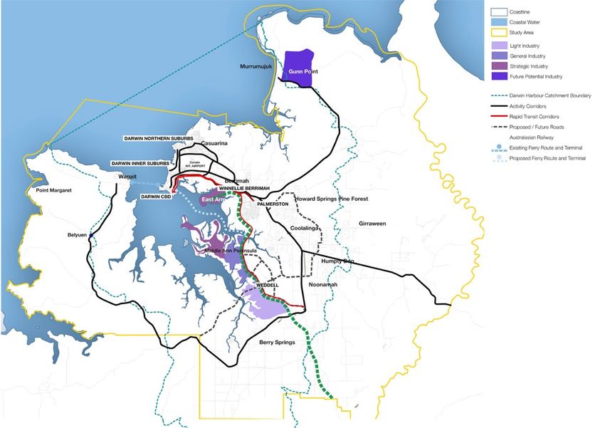
Industrial land identified in the Land Use Plan
includes East Arm and Middle Arm Peninsulas,
and development of a Weddell industrial precinct,
business park and commercial developments. The
Darwin industrial industrial land will cater for light, general and
options strategic industrial opportunities.
Potential for future (beyond 15 years) industrial
development at Gunn Point adjacent to the propose
Murrumujuk area can be considered.
Darwin Port Corporation controls and manages the land,
waterways and facilities within the Port of Darwin.
The Darwin port is expected to play a significant role
for the future trade with Asia, including Singapore.
The Darwin Port Corporation has announced the
Darwin Port East Arm Wharf Facilities Master Plan 2030 Land Use
Strategy, including a $150 million upgrade to facilities.
Additionally, the Government’s proposed Marine
Supply Base adjacent to the East Arm Wharf, and
associated reclamation, land based works and
package works would secure increased tonnage
movement and exports and job growth.
18 OVERVIEW GREATER DARWIN REGION LAND USE PLANGreater Darwin Region
– Industrial Land Use
TOWARDS 2030
0 5 10 20km
OVERVIEW 19Planning for growth Shaping the future
By 2025 The Land Use Plan is flexible and
intended to work to 2025 to assist
with short and medium term planning.
Growth The Region anticipates growth of
between 53,000 and 70,000 people Growth must be planned and, at its
core, sustainable.
The Land Use Plan accommodates
Dwellings The Region will have between
21,000 – 28,060 additional dwellings
a range of growth projections, while
planning for the highest predicted
growth rate.
Retail Core retail floor space will increase
by up to an additional 125,000 sqm
It provides an evidence-based
approach to the critical planning
decisions that will need to be taken
toward 2030.
Bulky goods Bulky goods retail space will increase
by up to an additional 76,000 sqm
Commercial Commercial office space will increase
by up to an additional 90,000 sqm
Industrial Industrial land will increase by up
to an additional 1,215 hectares for
various industrial uses.
Meeting demand for development – short, medium and long term
2006–2010 2011–2015 2016–2020 2021–2025 TOTAL
Up to… 5,245 7,220 6,890 8,705 28,060
additional Dwellings dwellings dwellings dwellings dwellings dwellings
Up to…
additional Retail including Bulky – 66,800m2 68,900m2 66,000m2 201,700m2
Goods
Up to…
– 29,700m2 31,800m2 28,500m2 90,000m2
additional Commercial
Up to… 1,215
– 230 hectares 405 hectares 580 hectares
additional Industrial Land hectares
20 OVERVIEW GREATER DARWIN REGION LAND USE PLANGreater Darwin Region
Land Use Framework
TOWARDS 2030
0 5 10 20km
OVERVIEW 21Section 01
The Land Use Plan’s
Role and Function
“The Northern Territory is a special place with
a great future. Plans must be laid down for
the next generation of Territorians.”
Territory 2030What is a Regional Land Use Plan?
Why do we need one?
The Greater Darwin Region is For example, most people in Darwin,
growing. More people are moving Palmerston and Litchfield routinely
here from interstate to enjoy our travel to and from their homes to
great lifestyle, young Territorians are community centres, cities, and rural
staying to take advantage of the job areas for work, school, health services,
opportunities and to raise families, recreation and shopping.
and older Territorians are choosing
to retire here. The Land Use Plan uses that
knowledge, combined with growth
With Government’s record predictions, to give Government
infrastructure program, and its the framework for mapping growth
commitment to securing major projects on a neighbourhood and municipal
like INPEX, a Marine Supply Base scale. It shows the relationships
and new mines, our economic and between designated urban centres
population growth will continue. and transport corridors and allows
Government to target investment
It is a central role of government to toward priority growth areas.
respond to and shape that growth
through planning based on sound Government can reserve land in
economic forecasts and developed in strategic areas for residential and
consultation with the community. industrial use, protect and preserve
environmentally significant land and
The Greater Darwin Region Land Use waterways, and provide important
Plan enables government to meet recreation spaces.
the future needs of our community
by assessing how we move around Importantly, the Land Use Plan
our community now, and using this is about ensuring decisions made
information for mapping growth areas today maximise the opportunities
and respond accordingly. for long term community needs. It is
developed to encompass the whole
area in which the people of a region
live, work and play.
TOWARDS 2030 THE PLAN’S ROLE AND FUNCTION 23The role of the Greater Darwin Region
Land Use Plan – Towards 2030
The Greater Darwin Region Land Use accommodate expanding industrial It will be integrated with the
Plan builds on the targets and priorities development and economic growth, comprehensive group of strategies
identified in the Territory 2030 strategy balanced with protection of the prepared by the Government to guide
developed in 2009 and is a key element environment. the future growth of the Territory.
of the Government’s plans for the These strategies include:
Territory’s future. This includes the timely provision and
>> Greening the Territory - Climate
linking of infrastructure and transport
Change Policy;
The first Darwin Region Land Use to land use planning, positioning
Plan, created in the mid 1980s and the Region to minimise the city’s >> Housing the Territory; and
revised in 1990, conceived of a ecological footprint. >> A Working Future.
sequence of new cities created around
the East, Middle and West Arms of There is adequate land available in The Land Use Plan respects the
Darwin Harbour. It proposed dams the Region to meet demand for future role of Local Government and looks
to control tidal movement and would residential, commercial, industrial and to support the achievement of the
have destroyed the natural systems social needs in a sustainable way. Council of Australian Governments
that sustain the harbour. It is a flexible plan showing where (COAG) agenda, agreed by Territory,
development can happen in the short, State and the Australian Governments.
Over the last decade, the high value medium and longer term.
placed by Territorians on the health The next step in finalising the
of the Darwin Harbour has been It identifies places for development, for Towards 2030 Land Use Plan is public
recognised by all levels of government. green space and for neighbourhoods consultation for community input and
This Land Use Plan reflects the with access to community facilities - support. Following public consultation
centrality of a healthy harbour to the keeping a balance between nature and all feedback received will be analysed
future of the Region. the built environment. and the Land Use Plan will be
modified where appropriate.
This new Land Use Plan is based on This Land Use Plan will be reviewed
accommodating a predicted population over time and in response to
growth in a range of between 53,000 changing economic and population
and 70,000 people in the period growth realities.
from 2006 to 2025. It will also
24 THE PLAN’S ROLE AND FUNCTION GREATER DARWIN REGION LAND USE PLANThe Land Use Plan’s relationship to
key Territory Government policies
Northern Territory 2030 Strategic Plan
Knowledge,
Economic Health and
Education Society Environment Creativity and
Sustainability Wellbeing
Innovation
S P A T I A L S T R A T E G Y
NTSP OBJECTIVES NTSP OBJECTIVES
Greater Darwin Region Land Use Plan –
Towards 2030
P O L I CY I N I T I AT I V E S P O L I CY I N I T I AT I V E S
Housing the A Working Growing the Population
Territory Future Territory Projections
Existing Land
Greening the Use Objectives,
Territory Plans and
Frameworks
“Our communities will be well planned, with cities
and towns planned to account for the needs of our
people, our environment and our sustainable future.”
Territory 2030
TOWARDS 2030 THE PLAN’S ROLE AND FUNCTION 25Better Urban Design
A key finding of the Territory 2030 existing infrastructure and community links to public transport and reduced
strategy was the community’s concern facilities. reliance on motor vehicles.
about the look and feel of the
Territory’s cities and towns. Growth in the Region will be balanced Our tropical climate requires large
between Greenfield developments in sites to provide for breezeways and
The Territory Government’s Urban outer areas, and redevelopment of natural light.
Design Advisory Panel was established vacant or underdeveloped land within
to promote exemplary urban design existing urban areas. Dual occupancy development would
and advise Government on issues only be allowed on large sites, with a
affecting the growth and development The Land Use Plan for the Region is proposed minimum area of 1,200 sqm.
of Darwin. focused on interconnected cities and
rural villages. Darwin city, with the Growth will also happen within
The Greater Darwin Region Land Use existing CBD, the southern suburbs rural villages.
Plan builds on that by reflecting a and the suburbs north of the airport,
This will assist in addressing not only
focus on new urban development to centred on the Casuarina regional
community concerns about density, but
bring a more ‘human’ dimension to the centre, will have greater density
also the greater community concern
streetscapes. through infill development.
around the need to recognise the
It promotes cities in the Region having Dual occupancy – or the development nature of the Territory’s climate and
a more compact urban form, promoting of two dwellings on a single allotment to design appropriately for it. This
walkability and sustainability for – is an important planning tool in involves using good design principles
residents. More compact cities deliver meeting residential demand and to create more fine grain streetscapes.
affordability, sustainability and strong, improving housing sustainability. It means fewer “inappropriate concrete
connected communities. boxes” that require traditional high
Dual occupancy accommodation energy cooling systems.
The Land Use Plan supports delivers ‘infilling’ through established
an increased emphasis on infill areas and allows more people to live
development, particularly around closer to the main centres, employment,
activity centres and along major shops, services and schools. It reduces
transport routes. This will create more urban sprawl and provides closer
compact urban form and better utilise
26 THE PLAN’S ROLE AND FUNCTION GREATER DARWIN REGION LAND USE PLANTOWARDS 2030 THE PLAN’S ROLE AND FUNCTION 27
Section 02
Context
It is essential that the government and the
wider community plan together for increased
growth and discuss the opportunities and
challenges growth presents.
A rapidly growing population

The Northern Territory covers about 15%    Planning for future growth               Base population forecast +
of Australia’s land mass, but is home to   The Territory Government is              53,000 by 2025
only 1% of the nation’s population.        targeting major projects and strategic   Northern Territory base series
The Territory’s population in June         investments that will support a          population projections show
2009 was 225,938 persons. Indigenous       sustainable economic future for          population growth from 114,360 to
Australians make up about one third        the Territory.                           167,778 people within the Region.
of the Territory’s population.             Projects such as INPEX, a Marine
                                                                                    High population forecast
                                           Supply Base, a record infrastructure
About 65% of the Territory’s                                                        +70,000 by 2025
population – 148,133 people – is           program, private development of new
                                           hotels and commercial and retail         Northern Territory high growth
concentrated around the major centres
                                           ventures, and expansion of major         population projections show growth
of Darwin and Alice Springs.
                                           assets such as the East Arm Wharf        from 114,360 to 184,494 people
As at June 2009, approximately 55% of      and the Darwin International Airport     within the Region. Appendix D for
the Territory population, representing     will all drive economic activity and     full details.
124,760 people, lived in the Darwin        bring more people to the Territory.
Statistical Division (SD). In Darwin
City, there were 75,908 people (33.6%);    A growth in population will
Palmerston-East Arm had 30,005             require Government investment in
residents (13.2%); and Litchfield had      infrastructure and community services
18,847 people (8.3%).                      such as schools, power and water,
                                           roads and health services.
Around 10% of the Region’s
population is Indigenous.                  Population statistics and growth
                                           projections are important for
The Territory’s population grew by         understanding and planning for the
2.5% – or 5,435 people – in the year to    potential future growth of the Region.
June 2009.
                                           They form the basis of understanding
Palmerston-East Arm SD experienced         potential future demand for land,
the fastest growth rate at 4.5%, an        and provide Government with the
increase of 1295 people from June          framework for the provision of
2008 to June 2009. Palmerston was          suitable land for development.
one of the fastest growing regions in
the country during the period.             Northern Territory Treasury forecasts
                                           that the population of the Darwin/
Darwin City Statistical Sub Division       Palmerston/Litchfield Region will grow
(SSD) grew by 2.6% – 1,924 people –        by between 53,000 and 70,000 by 2025.
and Litchfield SSD grew by 2.8%, or
an extra 514 people.

                                                                                                  TOWARDS 2030   CONTEXT 29
Population growth scenarios towards 2030
The Northern Territory Treasury High Growth Series to 2021 was taken and
continued as a straight-line forecast to 2025.
>> Scenario 1: Base population forecast
>> Scenario 2: High population forecast
200,000
180,000
160,000
140,000
120,000
Population
100,000
80,000
60,000
40,000
20,000
0
Scenario 1 (NTG) Scenario 2 (High growth)
2006 114,361 114,361
2011 127,844 129,901
2016 140,241 146,390
2021 153,393 164,099
2025 167,778 184,494
Summary of Greater Darwin Region Population Propections to 2025
Source: ABS Census Place of Enumeration Time Series Profile (2006), MacroPlan Australia (2009),
Elton Consulting (2009).
30 CONTEXT GREATER DARWIN REGION LAND USE PLANA changing context
The Northern Territory is home to a The Government has moved to The Region’s proportion of “couple
unique community that enjoys the best protect the Darwin Harbour for family with children” decreased
lifestyle in Australia. future generations, including significantly between 1996 and 2006,
protecting Glyde Point from heavy though it remains the most dominant
The average age of the Greater industry and rejecting damming of household type.
Darwin Region is 32, compared to a the Elizabeth River.
national average of 37. Like much of Traditional family homes are still
Australia, the Region has an ageing New recreation facilities have been needed, but there is a growing
population, with almost half of its developed, including a hugely popular demand for alternative housing styles.
population growth in the 55 to 74 age water park in Darwin’s northern
group. suburbs. Plans are underway for a The Government has moved to
water park and international sporting support Territorians looking to enter
It is a highly mobile community, with facilities in Palmerston. the property market by allocating 15%
high immigration, a routine turnover of residential land release to affordable
of Defence personnel, and fly in/fly In support of recreational fishing, and social housing, and enhancing its
out workers associated with mining significant funding has been HomestartNT loan scheme for low to
and large construction projects. committed to construct and upgrade middle income earners.
boat ramps and protect fish stocks.
About 10% of the Region’s population Investment is also being made in
is Indigenous, and the links of the The Waterfront development in accommodation for senior Territorians,
Larrakia people to the land and Darwin’s CBD has changed the face including new public housing villages
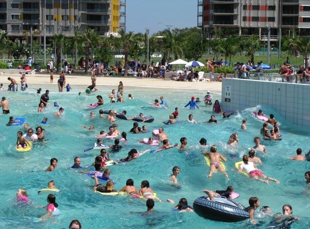
waters stretch back for thousands of the city, delivering a Convention and support for private village
of years. In 2009, the Northern Centre, wave pool, new hotels and development.
Territory Government, the Northern restaurants, residential apartments and
Land Council and Traditional Owners a Cruise Ship Terminal. Average individual and household
reached agreement regarding incomes in the Region are significantly
the Kenbi Land Claim over the Young Territorians are taking advantage higher than Australian averages.
Cox Peninsula. of the strong economy to build a A higher cost of living for some
career and family in the Territory. services, due in large part to the
Darwin is one of Australia’s In a change from the past, more Region’s remoteness from other parts
most multicultural cities, and the Territorians are now choosing to stay of Australia, can be challenging.
community welcomes people from on after retirement and are seeking to Significant groups of both high-end
around Australia and around the downsize their housing requirements. and low income earners are in the
world who move to the Territory and population profile.
embrace its opportunities and lifestyle.
Significant investments have been
made in preserving and enhancing the
Territory’s lifestyle.
TOWARDS 2030 CONTEXT 31The Region’s economic profile 2011
The 21st century will see Darwin take The ConocoPhillips LNG plant in
a pivotal role in the future growth Wickham Point confirmed Darwin as
of Australia. Australia’s second international oil and
gas hub. The Government is pursuing
As Australia’s northernmost capital, the INPEX Ichthys gas project.
Darwin is closer to Asia than other
Australian capital cities. It truly is the The Government has also announced
geographic gateway between Australia its intention to proceed with the
and Asia. establishment of a Marine Supply Base
– a purpose-built facility to deliver
Darwin is strategically located to rapid and efficient servicing of the
benefit from the emergence of the offshore petroleum and gas industry. It
new Asian economic powerhouses would ensure Darwin has world-class
such as China and India, and to marine infrastructure to support oil
continue to strengthen ties with and gas exploration and developments
existing partners such as Indonesia, in the Region.
Malaysia, Vietnam and Singapore.
Alice Springs
A $150 million upgrade of the East
Within five flying hours of Darwin are Arm Wharf has commenced, and is
Ho Chi Minh City, Singapore, Kuala supported by a record Government
Lumpur, Jakarta, Manila, Hong Kong, investment in the Territory’s
Bangkok and Hanoi – and more than infrastructure, including roads. Global
50 million people. demand for the Territory’s natural
resources, and investment in the
The Greater Darwin Region is
Territory’s tourism industry will also
a vital link between Australia’s
contribute to job opportunities and
communications, trade, transport
economic growth.
and logistics network and South East
Asian markets and the rest of the Such projects will attract and help
world. Appropriate planning for future retain skilled workers to support
growth and development is essential if ongoing economic growth.
the Top End is to meet its potential as
a trade hub. Alongside these industries is a growing
manufacturing sector, as well as the
The completion of the Alice Springs to stable Defence and government services.
Darwin railway in 2003 also heralded
the completion of the Australasia Retail investment is growing,
Trade Route, connecting Australia to evidenced in major projects such as
Asia via rail and sea through Darwin. the Bunnings expansions in Darwin
and Palmerston, and the AXIS 12°130°
The importance of the Trade Route proposal for the Darwin International
will grow in line with increased Airport precinct. Commercial
exploration and export to Asia of investments will continue to grow in
minerals, oil and gas. line with population increases, tourism
and business demand.
32 CONTEXT GREATER DARWIN REGION LAND USE PLANA strategic approach to the future
In preparing the Greater Darwin
Region Land Use Plan Consultation
The new tropical, sustainable and
liveable city of Weddell will take
Strategic Directions
Paper, the Territory Government has its place in the Darwin-Palmerston- The Land Use Plan’s strategic principles
taken a strategic approach to assessing Litchfield growth triangle as home have sustainability as a core focus.
where and how future development for up to 50 000 people.
will occur. A strategic approach to the future leads
Strategic industrial land will be to well-planned, well-designed and
In line with community views garnered made available to support the aim well-connected urban communities.
through Territory 2030, it’s proposed of the Region becoming a national
that Darwin, Palmerston and Litchfield and international trade and oil and A strategic approach will allow
will form a region of more compact gas hub. better integrated land use planning,
cities offering a tropical, sustainable transport and infrastructure corridors
and liveable lifestyle. A series of strategic principles will that assist government in delivering
provide the framework for planning more sustainable and cost-effective
It will be supported by strategic and implementing growth. outcomes for the community.
decisions such as the current
Government policy of allocating It will ensure a balance between the
15% of residential land release to community’s social and economic needs
affordable and public housing. and the needs of the environment.
Sustainability benchmarks used
nationally and globally have been
adapted to the Territory context to
ensure the Land Use Plan supports a
sustainable future for the Region.
TOWARDS 2030 CONTEXT 33Strategic directions for the Region
1 Accommodating future residential growth and diversity
2 Creating a more sustainable future
3 Supporting strong and healthy communities
4 Promoting economic development
5 Retaining a green region
6 Integrating land use and transport and infrastructure planning
7 Regional connections
Accommodating future The Land Use Plan will support Growth will be accommodated
residential growth and access and choice, assist housing through a combination of new
diversity affordability, and achieve compatibility development areas, increased density
between employment, transport along transport corridors and centres,
infrastructure and population growth. and the use of under-utilised land
01
within the broader urban framework.
Strategic
Direction
Creating a more Future development in the Region To build and maintain community
sustainable future will be managed with an emphasis on identity, reduce car dependency and
the ecological footprint maintaining utilise contemporary measures to
a healthy Darwin Harbour and conserve water and energy.
enhancing the economy and quality of
02
life of the residents.
Strategic
Direction
Supporting strong and Creating liveable communities with The coordinated and timely delivery
healthy communities distinct local character and identity. of social infrastructure for health,
sport, education and recreation to
Compact forms of residential development support the range of community
within discrete neighbourhoods, needs and to enhance social
incorporating a mix of uses and
03
inclusion for an ageing population,
Strategic residential densities to encourage
alternative modes of transport and the
disadvantaged communities and new
neighbourhoods.
Direction efficient delivery of infrastructure.
34 CONTEXT GREATER DARWIN REGION LAND USE PLANPromoting economic Growth accommodated in urban areas Access to transport to assist in linking
development through a combination of activity jobs to homes, ensuring employment
centres, specialised employment containment of the Region and
centres and additional growth through efficiency of services.
diversification in tourism
A hierarchy of centres to guide and
04
and recreation.
Strategic accommodate growth and provide
accessible facilities for communities.
Direction
Retaining a This will ensure that the tropical Sustainability at the centre of
green region lifestyle and natural environment and planning and urban development.
biodiversity continue to be enjoyed
by residents, and new development Recognising that the health of
is balanced with enhanced natural Darwin Harbour is central to the
future of the Region.
05
corridors and open space.
Strategic
Direction
Integrating land use and A series of strategies will be This will achieve critical elements
transport and infrastructure developed to improve integration of the national agreement, the
planning of land use planning, transport and Commonwealth of Australian
infrastructure planning. Governments Agreement (COAG) for
more compact and sustainable urban
06
development.
Strategic
Direction
Regional connections Consolidating urban growth to reduce Connectivity between alternative modes
travel time and distances and improve of transport, cycling and walking to
access to essential services. assist in reducing car dependence.
Mixed residential, commercial and The Greater Darwin Region Land Use
community development along Plan - Towards 2030 to introduce
Strategic
07
transport corridors to reduce the better coordination and sequencing
impacts of traffic congestion. of land use and transport planning to
Direction improve overall efficiency.
TOWARDS 2030 CONTEXT 35Section 03 Policies and Action The Towards 2030 Land Use Plan is a comprehensive strategic response to key challenges setting out a strategic plan, policies and an action oriented implementation strategy. 36 CONTEXT GREATER DARWIN REGION LAND USE PLAN
Targets of the Land Use Plan

The Greater Darwin Region Land             Park and Defence Support Hub, and
Use Plan – Towards 2030 provides           the push for new major projects such
                                                                                     Residential Growth
a roadmap for strategic policies           as the Marine Supply Base and INPEX.
and actions to ensure the supply of                                                  Land for industry
industrial and residential land to 2025.   Residential land release will continue,
                                           meeting the range of housing needs        Retail and bulky goods
It recognises the need to preserve         and aspirations in the community.
                                                                                     land supply
culturally significant sites, such         Palmerston East will be completed, a
as sacred sites, and to protect            new city of Weddell will be developed,    Commercial floor space
the Region’s environmental assets          and development of rural villages and
including the Darwin Harbour and           infilling through Darwin’s suburbs and    Infrastructure planning
waterways.                                 CBD will all help meet demand.
                                                                                     Social infrastructure
It supports Territorians’ desire for       The Land Use Plan is an important
a more sustainable community and           step in fulfilling the Territory’s        Funding infrastructure
will build on programs underway,           commitment to the Council of
including Green Suburbs and Green          Australian Governments objective          Climate change
Streetscapes and 5-star energy ratings     of ensuring “that Australian cities
                                                                                     Natural heritage and
for homes.                                 are globally competitive, productive,
                                                                                     biodiversity
                                           sustainable, liveable and socially
It maps the release of strategic           inclusive and are well placed to
land for industrial growth. Ongoing
                                                                                     Balanced housing market
                                           meet future challenges and growth.”
targeted land release will complement      (Appendix A)
the growth of the Darwin Business

                                                                                     TOWARDS 2030   POLICIES AND ACTIONS 37
Residential Growth
Around 28,060 additional dwellings by 2025
Based on Treasury high growth Construction of homes in Bellamack Dual occupancy on blocks 1,200 sqm
population forecasts, the Greater is well underway, with housing or larger is proposed, helping meet
Darwin Region is expected to need up construction in Johnston expected to residential demand close to urban
to 28,060 additional dwellings by 2025. start early in 2011. centres through infill developments.
Short-term population growth figures Charles Darwin University, in Rural villages and the new city of
highlight demand for an additional association with CIC Australia and the Weddell will play important roles in
1,500 to 1,700 dwellings a year. Larrakia Development Corporation meeting demand for housing.
Extensive activity is underway to meet have established a development
that demand. partnership for the residential Growth will occur at different rates
redevelopment of the Charles Darwin across the Region and will vary
Residential land is being turned University Palmerston campus. between the different land uses.
off faster than before, and
Government is allocating 15% of its Defence Housing Australia is progressing To monitor and plan for growth in
residential land release to social and its development of Muirhead in Darwin’s a sustainable manner, appropriate
affordable housing. northern suburbs. infrastructure will be planned for
and provided.
Activity is centred primarily on the In Darwin’s CBD, approximately 2000
new suburbs of Palmerston East – units have been developed since 2006. The Land Use Plan maps the delivery
Bellamack, Johnston, Zuccoli and of residential land across eight
Mitchell. Together these suburbs In the long term, planned residential precincts – Darwin City Centre;
will deliver housing for about 6000 land and housing development will Darwin Inner Suburbs; Darwin
Territorians over the next four years. continue to be balanced between Northern Suburbs; Winnellie/
new land releases – Greenfield sites, Berrimah; Palmerston; Weddell;
and redevelopment of vacant or Litchfield; and Cox Peninsula.
underdeveloped land – ‘brownfield’,
or infill sites.
38 POLICIES AND ACTIONS GREATER DARWIN REGION LAND USE PLANThe Region’s residential development potential
Name Number of Development Potential
additional
dwellings
up to 2025
1 up to 3,320 Growth will be accommodated through infill and redevelopment of vacant or underdeveloped sites.
Darwin City
Centre Higher density is expected within this area.
Existing zoning allows residential development up to 90m or 30 storeys.
Key waterfront sites are identified as places for higher density.
2 up to 2,900 There will be redevelopment of underdeveloped or vacant sites.
Darwin
Inner There is potential for more multiple dwellings along rapid transit corridors or activity corridors
Suburbs taking into account capacity and servicing costs.
3 up to 3,185 There will be a balance between new Greenfield development, such as Muirhead, and
Darwin redevelopment of underdeveloped or vacant sites. There is potential for more medium
Northern density residential development for a targeted number of dwellings.
Suburbs
Casuarina Shopping Centre area has been identified for increased density.
4 up to 1,825 Redevelopment of Berrimah Farm and Berrimah Prison as infill sites will produce a well located,
Winnellie/ sustainable mixed commercial, industrial and residential development. Proposed redevelopment will
Berrimah be in line with COAG principles and international objectives to decrease urban carbon footprints.
5 up to 5,470 Greenfield development, such as Bellamack, Johnston, Zuccoli and Mitchell and the Charles
Palmerston Darwin University site at Durack, will comprise the major growth within the Palmerston area.
Increased residential development within the CBD will be encouraged.
6 up to 7,230 The vision for Weddell is to provide 10,000 housing lots in a tropical, sustainable and liveable
Weddell city. As the Territory’s newest city on a Greenfield site, Weddell presents the opportunity to
design a sustainable city that will be a model for cities and towns of the future. The area will
need to accommodate various housing types and densities.
Planning for Weddell is underway, and approximately 7,230 dwellings are needed to
accommodate the growth within the next 15 years.
7 up to 3,130 Growth will be accommodated through more dense development within and around
Litchfield rural villages, with lots down to minimum 800 sqm, and rural residential land rural living
subdivision of between 4,000 sqm, 1ha, 2ha and 8ha. Infrastructure head works and
services will be required to support this in a cost efficient way. Girraween, Howards Springs
Pine Forest, Coolalinga, Fred’s Pass, Virginia, Humpty Doo, Noonamah and Berry Springs
will see development of infill sites.
8 up to 1,000 The Territory Government, Northern Land Council and Traditional Owners reached agreement
Cox regarding the Kenbi Land Claim in 2009. The Larrakia Development Corporation has flagged
Peninsula its intention for a mixture of residential and industrial development on the Peninsula, pending
final resolution of the Land Claim.
The cost of delivering infrastructure to the area will be significant. Based on current
infrastructure capacity, the Cox Peninsula could deliver about 241 additional services. Pending
the resolution of the Kenbi Land Claim, potential private development could deliver between
5,000 to more than 30,000 dwellings, pending the delivery of appropriate infrastructure.
This Land Use Plan provides for 1000 dwellings.
TOWARDS 2030 POLICIES AND ACTIONS 39Dwelling targets to 2025
The Land Use Plan identifies eight regional precincts for targeted residential development.
Identifying precincts for residential growth allows for targeted and coordinated planning and delivery of essential
and community infrastructure as the population grows.
Throughout, the targets set by the Land Use Plan incorporate a range of key issues, including:
>> Character of the area;
>> Location and access to services and activity centres;
>> Mix of densities and housing types;
>> Respecting the tropical lifestyle and climate; and
>> A healthy Darwin Harbour and catchment
Setting the overall Setting the dwelling
dwelling target numbers in each precinct
The residential growth of up to The proposed number of dwellings
an additional 28,060 dwellings suggested for each precinct was
was calculated for the Territory determined through investigations into
Government by economists and the existing and potential capacity of
planners using a series of detailed residential zoned land in each area.
investigations.
It included a review of available zoned
It is a high growth assessment based land in each area and analysis of the
on the 2006 population and then potential increase yields. The natural
the combined effect of a range of constraints in the Darwin, Palmerston
factors, including forecast economic and Litchfield Region were also
and population growth, household investigated to determine which land
size, available urban and rural village was capable of being developed.
land, and the provision of social and
transport infrastructure in line with Planners have also identified potential
the COAG agreement (Appendix A). infill sites that could be rezoned for
residential use.
40 POLICIES AND ACTIONS GREATER DARWIN REGION LAND USE PLANYou can also read