Outdoor Positioning Praktikum Mobile und Verteilte Systeme - Prof. Dr. Claudia Linnhoff-Popien André Ebert, Sebastian Feld, Thomy Phan ...
←
→
Page content transcription
If your browser does not render page correctly, please read the page content below
Praktikum Mobile und Verteilte Systeme

Outdoor Positioning

Prof. Dr. Claudia Linnhoff-Popien
André Ebert, Sebastian Feld, Thomy Phan
http://www.mobile.ifi.lmu.de

Sommersemester 2018

Outdoor Positioning
  Today:
  1. History of Positioning
  2. Positioning Fundamentals
  3. GPS – Global Positioning System
      – System architecture
      – Positioning via GPS
  4. Galileo
      – System architecture
      – Enhancements and new services
  5. Other Global Navigation Satellite Systems (GNSS)

Prof. Dr. C. Linnhoff-Popien, André Ebert, Sebastian Feld, Thomy Phan - Praktikum Mobile und Verteilte Systeme
Sommersemester 2018, Outdoor Positioning                                                                         2
1. History of Positioning I
  • Magnetic Compass (
1. History of Positioning II
  • In 1714, following many maritime accidents (including more than 1500
    vanished sailors with the loss of the fleet of admiral Clowdisley Shovell in
    1707), the British government settled the longitude act to offer a 20.000
    pounds reward (more than today´s 10 millions €) for a method to
    determine the longitude.

  • Expected accuracy (drift):
     – Maximum error: 0,5 degrees
     – 0,5 degrees = 30 nautical miles at the equator
       = motion during 2 minutes of earth rotation
       = 3 seconds per day during 40 days
       (40 days = a 6 week journey from England to the West Indies)

Prof. Dr. C. Linnhoff-Popien, André Ebert, Sebastian Feld, Thomy Phan - Praktikum Mobile und Verteilte Systeme
Sommersemester 2018, Outdoor Positioning                                                                         4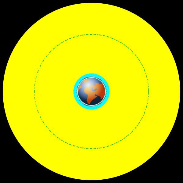
1. History of Positioning III
  • John Harrison (1693 – 1776)
  • Drift on H4 clock: 39.2 seconds after 47 days (4 times better than what
    was requested)

                                                             H1 (1735)
                                                                                                                 H2 (1741)
                                                             1,2m
                                                             34 kg

                                                            H3 (1757)                                            H4 (1761)
                                                                                                                 13cm
                                                                                                                 1.45 kg

Prof. Dr. C. Linnhoff-Popien, André Ebert, Sebastian Feld, Thomy Phan - Praktikum Mobile und Verteilte Systeme
Sommersemester 2018, Outdoor Positioning                                                                                     5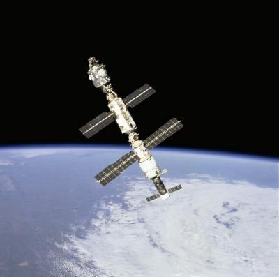
2. Positioning Fundamentals – Components

  • Positioning is determined by
           –     one or several parameters observed by measurement methods
           –     a positioning method for position calculation
           –     a descriptive or spatial reference system
           –     an infrastructure
           –     protocols and messages for coordinating positioning
         Positioning method                    Observable                                        Measured by

         Proximity sensing                     Cell-ID, coordinates, RSS                         Sensing for pilot signals
         Lateration                            Range or                                          Traveling time of pilot signals
                                                                                                 Path loss of pilot signals

                                               Range difference                                  Traveling time difference of pilot signals
                                                                                                 Path loss difference of pilot signals
         Angulation                            Angle                                             Antenna arrays
         Dead reckoning                        Position and                                      Any other positioning method and sensors:
                                               Direction of motion and                           Gyroscope
                                               Velocity and                                      Accelerometer
                                               Distance                                          Odometer
         Pattern matching or                   Visual images or                                  e.g., via Camera or
         learning algorithms                   fingerprints                                      Received signal strength

Prof. Dr. C. Linnhoff-Popien, André Ebert, Sebastian Feld, Thomy Phan - Praktikum Mobile und Verteilte Systeme
Sommersemester 2018, Outdoor Positioning                                                                                                      6
Proximity Sensing
  • Proximity is sensed by a station using (short) range pilot signals:

                                                                            ?
                                                !

Prof. Dr. C. Linnhoff-Popien, André Ebert, Sebastian Feld, Thomy Phan - Praktikum Mobile und Verteilte Systeme
Sommersemester 2018, Outdoor Positioning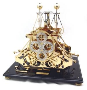
Lateration
  • Position is computed by a number of range measurements to known fix-
    points:

Prof. Dr. C. Linnhoff-Popien, André Ebert, Sebastian Feld, Thomy Phan - Praktikum Mobile und Verteilte Systeme
Sommersemester 2018, Outdoor Positioning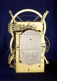
Angulation
  • Position is derived by the measured of the angle of an arriving signal by
    multiple stations at known fix-points:

Prof. Dr. C. Linnhoff-Popien, André Ebert, Sebastian Feld, Thomy Phan - Praktikum Mobile und Verteilte Systeme
Sommersemester 2018, Outdoor Positioning
Dead Reckoning
• From a fixed starting position, the movement of a mobile device is
estimated (e.g., using velocity and direction of movement)
• Position becomes more inaccurate with each estimation
• Recalibration may be necessary
x3
! a2
x2
a1
x1
Prof. Dr. C. Linnhoff-Popien, André Ebert, Sebastian Feld, Thomy Phan - Praktikum Mobile und Verteilte Systeme
Sommersemester 2018, Outdoor PositioningFingerprinting
• Position is derived by the comparison of location dependent online
measurements with previously recorded data:
• Indoor Navigation / Fingerprinting via RSS measurements
Prof. Dr. C. Linnhoff-Popien, André Ebert, Sebastian Feld, Thomy Phan - Praktikum Mobile und Verteilte Systeme
Sommersemester 2018, Outdoor Positioning2.1 Positioning Fundamentals – Reference Systems
• Goal of positioning: derive the geographic position of a
target with respect to a spatial reference model
• Spatial reference model
– Coordinate system (Ellipsoidal/Cartesian)
– Geodetic datum, e.g., WGS-84
– Projection (if location is to be represented on a map), e.g., Mercator projection
Prof. Dr. C. Linnhoff-Popien, André Ebert, Sebastian Feld, Thomy Phan - Praktikum Mobile und Verteilte Systeme
Sommersemester 2018, Outdoor Positioning 122.2 Positioning Fundamentals - Infrastructures Prof. Dr. C. Linnhoff-Popien, André Ebert, Sebastian Feld, Thomy Phan - Praktikum Mobile und Verteilte Systeme Sommersemester 2018, Outdoor Positioning 13
3. Global Satellite Positioning Systems in the past

  • Russian satellite Sputnik launched in 1957
     – Proof of the ability to track artificial objects in space via short wave
       radio signals
     – Worldwide triangulation program (BC-4): simultaneously
       photographing reflective satellites by several sites separated by some
       4000 km
     – Doppler shift in the signal broadcast by a satellite could be used to
       determine exact time of closest approach. Together with the
       ephemerides this leads to precise positioning anywhere in the world.
  • Navy Navigation Satellite System (NNSS), also called TRANSIT
     – Predecessor of GPS
     – Six satellites / 1100km altitude
     – Primarily for vessel and aircraft positioning
     – 1m accuracy if point was occupied for several days
     – A satellite passed overhead only every 90 minutes

Prof. Dr. C. Linnhoff-Popien, André Ebert, Sebastian Feld, Thomy Phan - Praktikum Mobile und Verteilte Systeme
Sommersemester 2018, Outdoor Positioning                                                                         14
3. GPS – Mission Goals
• Defined by the US Department of Defense (DoD), developed to replace
the TRANSIT system and to deliver not only position, but also accurate
time and speed.
• Initial goals
– User receiver cost < 10.000 $ and „5 bombs in the same hole“
– Positioning anywhere, continuously & in all weather conditions
• Services
– Standard positioning service (SPS) open to civil users, but single-
frequency with L1 coarse/acquisition signal 1575.42 MHz, i.e. no
ionosphere effect correction, selective availability
– Precise positioning service (PPS), dual-frequency, using P(Y) signals in
L1 and L2 (1227.60 MHz) bands, with military control access (key for
pseudo-code)
Prof. Dr. C. Linnhoff-Popien, André Ebert, Sebastian Feld, Thomy Phan - Praktikum Mobile und Verteilte Systeme
Sommersemester 2018, Outdoor Positioning 153.1 GPS - History
1973 Decision to develop satellite navigation system
1978-1985 11 Block-I satellites launched
1989 First Block-II satellite launched
Dec 1993 Initial Operational Capability (IOC)
Mar 1994 Last Block-II satellite
July 1995 Full Operational Capability (FOC)
May 2000 Deactivation of Selective Availability
Sep 2005 First IIR-M GPS satellite
Prof. Dr. C. Linnhoff-Popien, André Ebert, Sebastian Feld, Thomy Phan - Praktikum Mobile und Verteilte Systeme
Sommersemester 2018, Outdoor Positioning 163.2 GPS - Satellites
Geostationary orbit (ca. 36.000 km)
communication, TV, and meterology
MEO: Medium Earth Orbit
e.g., GPS satellites (ca. 20.200 km)
LEO: Low Earth Orbit
e.g., ISS (ca. 700 km)
Prof. Dr. C. Linnhoff-Popien, André Ebert, Sebastian Feld, Thomy Phan - Praktikum Mobile und Verteilte Systeme
Sommersemester 2018, Outdoor Positioning 173.2 GPS - Satellites
• Block-I
– Weight: 845 kg; Lifespan: 4.5 years;
– Energy: Solar panels (400W); Nickel-Cadium batteries
– Out-of-order since 1996
• Block-II/-IIA
– Weight: 1500kg; Lifespan: 7.5 years; Wingspan: 5.1m
– Four atomic clocks (2 rubidium, 2 cesium)
• Block-IIR
– Weight: 2000kg; Costs: 75 million USD
– Three atomic clocks (all rubidium clocks)
– Second civil signal (L2C)
– New military signal with new code
• Block-IIF
– Third frequency for civil use (L5)
Prof. Dr. C. Linnhoff-Popien, André Ebert, Sebastian Feld, Thomy Phan - Praktikum Mobile und Verteilte Systeme
Sommersemester 2018, Outdoor Positioning 183.3 GPS – Components
• Space segment
– 24 satellites circulating the Earth every 12
sidereal hours on six orbits
– Each satellite is equipped with onboard
atomic clocks
– Orbits are equally spaced 60° apart from
each other with an inclination angle of 55° to
the equator
– Orbit altitude: approx. 20,180 km
• Control segment
– Initially: Five ground stations for monitoring
and controlling the satellites
– In 2005: Six additional monitoring stations
– Adjust or synchronize satellites
• User Segment
– GPS receiver
– Applications: land, sea, and air navigation, as
well as military purposes and location-based
services
Prof. Dr. C. Linnhoff-Popien, André Ebert, Sebastian Feld, Thomy Phan - Praktikum Mobile und Verteilte Systeme
Sommersemester 2018, Outdoor Positioning 193.4 GPS – Circular Lateration
• Known:
– Position pi = (xi, yi, zi) for satellites i ϵ {1, 2,
3, 4} at time ti
– Inaccurate reception time tri
– Speed of light c
• Unknown:
– Position p
• Calculation:
– ri = (tri – ti)*c for i = 1,2,3
– Estimate position pest : intersection of
spheres (centered on satellite i with radius
ri)
– pest contains the coordinates (x,y,z) and ist
determined on basis of the signals 1,2,
and 3
– pest is not accurate due to different clock
times at the satellites and the receiver
– Signal 4 is now used to determine the
corrected reception time t
Prof. Dr. C. Linnhoff-Popien, André Ebert, Sebastian Feld, Thomy Phan - Praktikum Mobile und Verteilte Systeme
Sommersemester 2018, Outdoor Positioning3.5 GPS - Possible Errors
• Satellite clocks (although four highly accurate atomic clocks) can cause
time error of 10ns
• Satellite position is only known up to approx. 1-5m
• Receiver has only limited accuracy
• Multipath propagation
• Satellite geometry (Dilution Of Precision, DOP)
• Signal (speed of light) slow down when crossing ionosphere and
troposphere
ionosphere
Prof. Dr. C. Linnhoff-Popien, André Ebert, Sebastian Feld, Thomy Phan - Praktikum Mobile und Verteilte Systeme
Sommersemester 2018, Outdoor Positioning 213.6 Differential GPS (DGPS)
• Reference station (RS) located at a known and accurately surveyed point
• RS determines its GPS position using four or more satellites
• Deviation of the measured position to the actual position can be
calculated
• Variations are valid for all the GPS receivers around the RS
• Runtime corrections are transmitted by radio
< 200 km
Prof. Dr. C. Linnhoff-Popien, André Ebert, Sebastian Feld, Thomy Phan - Praktikum Mobile und Verteilte Systeme
Sommersemester 2018, Outdoor Positioning 223.7 Satellite-based Augmentation Systems
ionosphere
Prof. Dr. C. Linnhoff-Popien, André Ebert, Sebastian Feld, Thomy Phan - Praktikum Mobile und Verteilte Systeme
Sommersemester 2018, Outdoor Positioning 234. Galileo
• European GNSS
• Publicly available since December 2016
• Independence of other systems
• More services: Open, Commercial, Safety of Life, Public Regulated, Search
and Rescue
• Advantages
– Precision: Combination of GPS and Galileo in dual receivers is about
to lead to higher precision
– Availability: Higher number of satellites to improve the availability.
– Coverage: Galileo aims to provide a better coverage at high latitudes
due to the location and inclination of the satellites.
Prof. Dr. C. Linnhoff-Popien, André Ebert, Sebastian Feld, Thomy Phan - Praktikum Mobile und Verteilte Systeme
Sommersemester 2018, Outdoor Positioning 244.1 Galileo – Services
• Open Service
– basic signal provided free-of-charge
• Safety-of-Life Service
– Enhanced signal including an integrity function that will warn the user
within a few seconds in case of a malfunction. This service will be offered
to the safety-critical transport community, aviation, etc.
• Commercial Service
– combination of two encrypted signals for higher data throughput rate and
higher accuracy authenticated data;
• Public Regulated Service
– two encrypted signals with controlled access for specific users like
governmental bodies; security against manipulation, availability garanties
• Search And Rescue Service
– Galileo will contribute to the international COSPAS-SARSAT cooperative
system for humanitarian search and rescue activities. Each satellite will be
equipped with a transponder transferring the distress signal from the user
to the Rescue Coordination Centre and informing him that his situation
has been detected.
http://ec.europa.eu/enterprise/policies/satnav/galileo/programme/index_en.htm
Prof. Dr. C. Linnhoff-Popien, André Ebert, Sebastian Feld, Thomy Phan - Praktikum Mobile und Verteilte Systeme
Sommersemester 2018, Outdoor Positioning 254.2 Galileo – Operation
• Galileo programme structured in two phases
– In-Orbit Validation (IOV) phase
• Qualifiying and validating the systems through in-orbit tests
• Two experimental satellites: Dec 2005, Apr 2008
• Four operational satellites: Q3/4 2011, Q1/2 2012
– Full Operational Capability (FOC) phase
• Deployment of remaining ground and space infrastructure
• Intermediate initial operational capability: 18 satellites in
operation
• Full system: 30 satellites, control centers located in Europe and a
network of sensor stations and uplink stations installed around
the globe
Prof. Dr. C. Linnhoff-Popien, André Ebert, Sebastian Feld, Thomy Phan - Praktikum Mobile und Verteilte Systeme
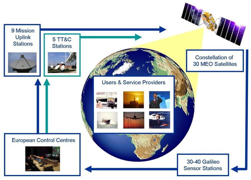
Sommersemester 2018, Outdoor Positioning 264.3 Galileo – Architecture
• 30 satellites in MEO: Each
satellite will contain
– a navigation payload
– search and rescue
transponder
• 30-40 sensor stations
• 3 control centers
• 9 Mission Uplink stations
• 5 TT&C stations.
http://ec.europa.eu/enterprise/policies/satnav/galileo/programme
/index_en.htm
Prof. Dr. C. Linnhoff-Popien, André Ebert, Sebastian Feld, Thomy Phan - Praktikum Mobile und Verteilte Systeme
Sommersemester 2018, Outdoor Positioning 275. Other GNSS
• Global Navigation Satellite System (GLONASS)
– Program started in 1982
– System currently operated by the Russian Defense Ministry
– 24 planned satellites
– 3 orbital levels
– Orbital altitude of 19,100 km
– Full operation since 1996
• Compass Navigation Satellite System (CNSS)
– China’s second-generation satellite navigation system (also known as
BeiDou 2)
– Long-term goal: Development of as system similar to the GPS and
GLONASS
– 25~35 satellites: 4 GEO satellites and MEO satellites
– Two levels of positioning service: Open and restricted (military)
– Coverage: Initially only neighboring countries, later on extension to global
navigation satellite system.
– Launches: 1 MEO (Apr 07) and 3 GEO (Apr 09 – June 10)
Prof. Dr. C. Linnhoff-Popien, André Ebert, Sebastian Feld, Thomy Phan - Praktikum Mobile und Verteilte Systeme
Sommersemester 2018, Outdoor Positioning 28Hands-on
• Create location-based applications with Android location services
– Android Developer tutorials
https://developer.android.com/guide/topics/location/strategies
– Get familiar with typical challenges:
• Multitude of location sources
• User Movement
• Varying accuracy
– Applying an application process chain satisfying your application’s
individual needs (e.g., demands for accuracy or update-rate):
Source: https://developer.android.com/guide/topics/location/strategies
Prof. Dr. C. Linnhoff-Popien, André Ebert, Sebastian Feld, Thomy Phan - Praktikum Mobile und Verteilte Systeme
Sommersemester 2018, Outdoor Positioning 29You can also read