OUTDOOR RECREATION AND OPEN SPACE PLAN FOR FOND DU LAC COUNTY 2020-2024 - Fond du Lac County Planning & Parks Department February 2020
←
→
Page content transcription
If your browser does not render page correctly, please read the page content below
OUTDOOR RECREATION
        AND
  OPEN SPACE PLAN
        FOR
FOND DU LAC COUNTY

     2020-2024

             Taycheedah Creek Bridge, Peebles Trail

             Fond du Lac County
             Planning & Parks Department
             February 2020
TABLE OF CONTENTS

INTRODUCTION .......................................................................................................... 1

SECTION 1: FOND DU LAC COUNTY
GENERAL DESCRIPTION OF COUNTY............................................................................ 2
          GEOGRAPHY ......................................................................................................................................2
          GEOLOGY AND TOPOGRAPHY ...........................................................................................................2
          WATERSHEDS ....................................................................................................................................5
          LAND USE AND AGRICULTURE...........................................................................................................5
          POPULATION .....................................................................................................................................7

AVAILABLE NATURAL RESOURCES ............................................................................... 9
          LAKES .................................................................................................................................................9
          STREAMS ..........................................................................................................................................9
          WETLANDS ........................................................................................................................................9
          WOODLANDS .....................................................................................................................................9
          HILLS, ESCARPMENTS ......................................................................................................................10

STATE RECREATION AREAS ....................................................................................... 10
          KETTLE MORAINE STATE FOREST ....................................................................................................10
          HORICON NATIONAL WILD LIFE REFUGE .........................................................................................11
          ELDORADO MARSH .........................................................................................................................11
          OTHER STATE LAND .........................................................................................................................11
          ICE AGE RESERVE .............................................................................................................................11

MUNICIPAL RECREATION FACILITIES ......................................................................... 12

COUNTY RECREATIONAL FACILITIES .......................................................................... 14
          FAIRGROUNDS .................................................................................................................................14
          GOTTFRIED PRAIRIE & ARBORETUM ...............................................................................................14
          ROLLING MEADOWS GOLF COURSE ................................................................................................15
          CALVARY MARSH .............................................................................................................................15
          COLUMBIA PARK .............................................................................................................................15
          HOBBS WOODS NATURE AREA........................................................................................................15
          HIGHWAY 45 WAYSIDE PARK ..........................................................................................................16
          HIGHWAY 49 WAYSIDE PARK ..........................................................................................................16
NORTHWOODS PARK ......................................................................................................................16
         RIGGS COUNTY PARK .......................................................................................................................16
         RAUBE HISTORICAL SITE ..................................................................................................................16
         ROOSEVELT COUNTY PARK ..............................................................................................................16
         SHAGINAPPI NATURAL AREA PARK .................................................................................................17
         VETERANS PARK ..............................................................................................................................17
         WAUPUN COUNTY PARK .................................................................................................................17
         WOLF LAKE COUNTY PARK ..............................................................................................................17

COUNTY RECREATION TRAILS ................................................................................... 21
         COUNTY SNOWMOBILE TRAIL SYSTEM ...........................................................................................21
         EISENBAHN STATE TRAIL .................................................................................................................21
         NORTHWESTERN TRAIL ...................................................................................................................22
         MASCOUTIN VALLEY PARK TRAIL ....................................................................................................22
         PEEBLES TRAIL .................................................................................................................................22
         PRAIRIE TRAIL ..................................................................................................................................22
         WILD GOOSE STATE TRAIL ...............................................................................................................22

SECTION 2: THE PLANNING PROCESS
THE PLANNING PROCESS .......................................................................................... 23

GOALS AND OBJECTIVES ........................................................................................... 28

SECTION 3 RECREATION DEMAND AND NEEDS
RECREATION DEMAND AND NEEDS .......................................................................... 29

SECTION 4: PLAN RECOMMENDATIONS
COUNTY RECREATIONAL FACILITIES .......................................................................... 31
         ACQUISITION ...................................................................................................................................31
         DEVELOPMENT BY FACILITY ............................................................................................................32
         COLUMBIA PARK .............................................................................................................................32
         HIGHWAY 45 WAYSIDE ....................................................................................................................32
         WAUPUN PARK ................................................................................................................................32
         RIGGS COUNTY PARK .......................................................................................................................32
         HOBBS WOODS NATURAL AREA......................................................................................................32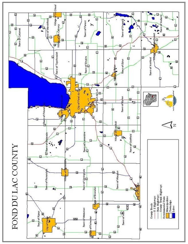
SHAGINAPPI NATURAL AREA PARK .................................................................................................33
         NORTHWOODS PARK ......................................................................................................................33
         WILD GOOSE STATE TRAIL ...............................................................................................................33
         MASCOUTIN VALLEY STATE TRAIL ...................................................................................................33
         PEEBLES TRAIL .................................................................................................................................33
         EISENBAHN STATE TRAIL .................................................................................................................34
         STATE ROAD PEDESTRIAN-BICYCLE FACILITIES ................................................................................34
         GOTTFRIED ARBORETUM ................................................................................................................34

SECTION 5: CAPITAL IMPROVEMENT PLAN
CAPITAL IMPROVEMENT PLAN ................................................................................. 34
UW-EXTENSION EDUCATION, AGRICULTURE
AND RECREATION COMMITTEE
OF THE
FOND DU LAC COUNTY BOARD
Michal J. Will
Chair
Sam Kaufman
Vice-Chair
Sarah A. Everson
Robert J. Giese
John J. RickertIntroduction
This Outdoor Recreation and Open Space Plan for Fond du Lac County is an update of the 2015
plan. This plan will serve Fond du Lac County as a guide in recreation and park development
and will enable the county to participate in State and Federal recreation grant programs, which
require such a plan as a prerequisite.
Upon adoption by the Fond du Lac County Board of Supervisors, this revised recreation plan will
continue in use as a guide in recreation and park planning and development, and will enable
Fond du Lac County to maintain eligibility for Federal and State recreation grants. Attached at
the end of the plan is a capital improvement plan for county parks and trails.
1SECTION 1: FOND DU LAC COUNTY
GENERAL DESCRIPTION OF COUNTY
Geography
Fond du Lac County is located in east central Wisconsin at the southern end of Lake Winnebago.
The total land area of the county is 724 square miles or 463,360 acres. The county consists of
21 civil towns, 9 villages and 3 cities. Refer to Map 1 on the next page.
In 2010, 101,633 people lived in Fond du Lac County, according to the U.S. Census of
Population. About two-thirds of the population lives in the cities and villages; the City of Fond
du Lac alone contains over 43,000 people. The other third of the population is scattered
throughout the 21 unincorporated towns, with some concentrations along Lake Winnebago and
near the City of Fond du Lac in the Towns of Auburn, Empire, Fond du Lac, Friendship and
Taycheedah.
Most growth in population will occur within cities and villages around the county. The majority
of the county will retain much of its rural character. The towns of Auburn, Ashford, Empire,
Fond du Lac, Friendship and Taycheedah will continue to urbanize.
Geology and Topography
There are two main types of bedrock under Fond du Lac County: the older crystalline rock such
as granite and the younger sedimentary rocks such as dolomite, sandstone and shale. In some
places, this bedrock appears at the surface, as does the dolomite of the Niagara Escarpment
and the sandstone and granite at the eastern edge of the county. In most parts of the county,
unconsolidated overburden consisting of sand, gravel and clay covers the bedrock. The
Pleistocene Glaciers last seen in Wisconsin about 10,000 years ago left this overburden. This
overburden ranges in thickness from several feet to several hundred feet. In some places, this
overburden is well sorted; for example, the several hundred feet of clay deposited by the glacial
lakes or the sand and gravel found in kames and eskers.
As they advanced and withdrew, the various stages of the glacier left deposits, which in
combination with the bedrock formation, form the major topographic feature of the County.
Glacial moraines and other deposition features such as drumlins, kames and eskers form the
hills and valleys of the eastern half of the County. The Niagara Escarpment forms the high
ridge, which runs just east of Lake Winnebago and swings southwest past Oakfield. The low,
flat area around Lake Winnebago was the bed of a large glacial lake. The gently rolling
topography of the western part of the county is mostly ground moraine, and the ridges and
outcrops near Ripon and Fairwater are bedrock controlled. Lake Winnebago and the Horicon
Marsh are part of a long broad valley carved by a lobe of the glacier in the relatively soft shale
bedrock previously found there.
2Map 1 Towns, Villages & Cities, Fond du Lac County
3Map 2 Watersheds, Rivers and Lakes
4Watersheds
According to the Soil Conservation Service, there are seventeen major watershed areas in Fond
du Lac County, draining into ten river systems. Only one major river, the Fond du Lac River, is
located completely within the County; the other rivers flow out of the County. View Map 2 on
the preceding page for the locations of these watersheds.
Table 1 Major Watersheds of Fond du Lac County
Watershed Acreage
Milwaukee River, West Branch 20,560
Milwaukee River, Main Branch 53,500
Milwaukee River, East Branch 10,280
Milwaukee River, North Branch 411
Sheboygan River 50,990
Manitowoc River 18,500
Mullet River 12,336
Grand River 13,673
Silver Creek 31,663
Rush Creek 2,755
Fox River 8,779
Fond du Lac River, East Branch 75,700
Fond du Lac River, West Branch 63,593
Upper Rock River 62,002
Rock River, East Branch 9,889
East Shore Lake Winnebago 12,028
West Shore Lake Winnebago 23,233
Total Acreage 469,892
Source: Fond du Lac County Farmland Preservation Plan, 1980
The Manitowoc, Sheboygan and Milwaukee Rivers begin in the eastern part of the county and
flow eastward to Lake Michigan. These three rivers and their tributaries drain just over a third
of the county. The Fond du Lac River, flowing to Lake Winnebago, drains the central third of
the county. The headwaters of the Rock River lie over a sub-continental divide in the
southwestern part of the county, and drain southward into the Mississippi River.
Land Use and Agriculture
Agriculture is the major land use in Fond du Lac County. Data from the 2017 Census of
Agriculture show that approximately 68 percent of the total land area in the county (about
317,371 out of 463,360 acres) is in farms. This figure is down from 335,745 acres for about a
1,800-acre loss of farmland every year. All “land in farms” is not productive cropland, because
5wetlands and woodlands that are owned by farmers are included in that acreage, but it is a
revealing statistic.
According to the 1972 Census of Agriculture, about 89 percent of the land in Fond du Lac
County was in farms. By 2017, land in farms dropped to 68 percent. The number of farms has
declined by more nearly half between 1972 and 2017, from 2,380 farms to 1,244 farms. Some
of these changes are due to differences in classifications between the years, but the decrease
of land in farms is also attributable to urbanization, and the decrease in the number of farms is
partially due to the increase in average farm size. The following chart graphs the trends of farm
size and the number of farms in Fond du Lac County for the 1972 to 2017 period. Over the 45-
year period, more than 147 square miles or the equivalent of about four townships worth of
agricultural land was lost to development.
Figure 1 Farmland in Acres & Average Farm Size, 1972-2017, Fond du Lac County
Source: 2017 Census of Agriculture, USDA.
6Population
The 2010 U.S. Census population count for Fond du Lac County was 101,633. Decennial growth
in population reached a peak in 1960 with a 12.2% increase. County population trends have
generally been in line with state trends. Table 2 below illustrates population growth since
1950.
Table 2 Population Growth, 1950-2010 Fond du Lac County
% %
Year County Change State Change
1950 67,829 8.8% 3,434,575 9.5%
1960 76,085 12.2% 3,951,777 15.1%
1970 84,567 11.1% 4,417,821 11.8%
1980 88,964 5.2% 4,705,767 6.5%
1990 90,083 1.3% 4,891,769 4.0%
2000 97,296 8.0% 5,254,930 7.4%
2010 101,633 4.5% 5,686,986 8.2%
Source: U.S. Census Bureau, Population Division
Figure 2 Population by Age Group, 1950-2010, Fond du Lac County
Source: US Census, 1950-2010
7Figure 2 illustrates the age trend of county residents. Figure 2 shows a gradual trend toward an
aging population and a stable population of persons under age 18. As persons in the 19-64 age
group grow older, there will likely be an increasing number of persons of retirement age in the
county. Outdoor recreation opportunities for retirement age persons may need special
consideration as the county plans for parks and open space in the coming decades.
Census figures for 2010 show the county population as 65% urban and 35% rural. Urban means
all persons living in residences within incorporated cities and villages and within towns of 2,500
or more inhabitants. The 2010 census shows a large shift away from rural to urban areas within
the county.
Table 3 Population by Urban & Rural Residence, 1960-2010, Fond du Lac County
Year Urban Rural Total % Urban % Rural
1960 43,517 31,568 75,085 58% 42%
1970 48,319 36,248 84,567 57% 43%
1980 49,511 39,453 88,964 56% 44%
1990 58,397 31,685 90,082 65% 35%
2000 60,225 37,071 97,296 62% 38%
2010 65,930 35,703 101,633 65% 35%
Source: US Census, 1960-2010
Figure 3 below indicates a modest growth in population in the county through 2030 followed by
a taper and decline in population by 2040.
Figure 3 Population Projections, Wisconsin & Fond du Lac County
Source: Department of Administration, State of Wisconsin. 2013.
8AVAILABLE NATURAL RESOURCES
Existing natural resources within Fond du Lac County provide a variety of recreational
opportunities. These resources include lakes, streams, wetlands, woodlands and some rolling
hills and escarpments. Much of the county is agricultural land, which provides open space and
some wildlife habitat but little recreational opportunity to non-landowners.
Lakes
There are 48 lakes in Fond du Lac County, many of which have public access. Lake Winnebago
is by far the largest of these lakes, and provides outstanding opportunities for fishing and water
sports. Public access to Lake Winnebago is adequate, but not well developed outside of the
City of Fond du Lac.
Other lakes include Rush, Long, Kettle Moraine, Wolf, and Mauthe. All have public access and
are popular for recreational purposes. Of the major lakes in the county, only Lake De Neveu
and Mullet Lake are not readily accessible to the public.
Streams
There are about 50 streams and rivers within Fond du Lac County, but most are small, slow and
shallow. The longest sections of stream are the Milwaukee River, the Rock River and the Fond
du Lac River.
Fishing is poor in most of the local streams, although some trout do exist at the headwaters of
the East Branch of the Milwaukee River in the Kettle Moraine area, and in Parsons Creek before
its confluence with the East Branch of the Fond du Lac River.
Wetlands
Wetlands, many of them associated with streams and lakes, are a valuable recreational and
environmental resource in Fond du Lac County. According to the WDNR 2007 Wetland
Inventory, there are approximately 70,000 acres of wetlands in the county. About 15% of the
land area of the county is wetlands. Several publically owned, large wetland areas, described in
the next section, are easily accessible. Most of the smaller wetland areas are located on private
land and are not open to the public. Both large and small wetland areas do however, continue
to function as assets to the environment in that they provide wildlife and waterfowl habitat,
fish spawning areas, and help maintain surface water quality by filtering runoff.
Woodlands
Woodlands once covered between 40 and 80 percent of Fond du Lac County, and now make up
between 10 and 30 percent of the land cover. Areas where woodlands still exist are areas of
public ownership such as the Northern Unit of the Kettle Moraine State Forest, or areas that
have physical characteristics that make them poor farmland. Areas of high bedrock, some wet
9soils, steep slopes and similar terrain that did not make good farmland remain in tree cover and
now comprise a valuable asset to the environment.
Woodlands, even small ones on farms, are a valuable resource in this highly agricultural county.
They provide wildlife habitat, reduce soil erosion, help to cleanse the air, and provide
recreational opportunities. Both the State and the County provide recreational facilities that
are wooded and easily accessible to the public.
Hills, Escarpments
Much of the terrain of Fond du Lac County, particularly the central and western parts, is nearly
flat to gently rolling. Only in the eastern part of Fond du Lac County, with its drumlin fields and
the Niagara Escarpment, and in the Ripon area, are hills available for such winter sports as
sledding and skiing. The only public sledding hills in Fond du Lac are man-made and are located
at Buttermilk Park, the UW Fond du Lac Campus and Adelaide Park. No public downhill ski
areas exist in the entire county.
The Niagara Escarpment, which curves through Fond du Lac County for about fifteen miles, is
the most significant relief found in Fond du Lac County. The Oakfield Ledge State Natural Area
and the Town of Taycheedah’s Kiekhaefer Park are the only public lands that offer recreational
opportunities on the Escarpment.
STATE RECREATION AREAS
The State of Wisconsin owns some of the most significant recreational resources available in
Fond du Lac County. These properties are a significant recreation resource for county residents
and visitors.
Kettle Moraine State Forest
Kettle Moraine State Forest, located in the southeastern part of Fond du Lac County, is a
10,582-acre portion of the 27,725-acre northern unit of Kettle Moraine State Forest.
Made up of geological formations caused by retreating glaciers, the DNR manages the forest for
forestry and outdoor recreation. Textbook examples of glacial landforms are scattered
throughout the forest, such as drumlins, kames, eskers and kettles. Botanically, the forest
offers a lot of plant diversity with nearly sixty species of trees present, together with numerous
shrubs, wild flowers, ferns and other plant life. There are nearly 40 mammal species ranging
from the white- tailed deer to the small mammals. Birds are seen everywhere, especially
during the spring and fall migrations. Some of the higher ridges and eskers provide excellent
viewing areas.
The major recreational developments within the forest are located at Mauthe Lake south of
New Prospect, and at Long Lake north of Dundee. Both have excellent camping and hiking
facilities. Mauthe Lake offers electricity, trailer sites, tent camping, fireplaces, picnic tables,
sanitary facilities and drinking water, while Long Lake offers all of the above except electricity.
10Hiking, biking, equestrian, snowmobile and cross-country ski trails are available in several parts
of the Kettle Moraine.
Horicon National Wildlife Refuge
Horicon Marsh lies in northern Dodge and southern Fond du Lac Counties, at the junction of the
east and west branches of the Rock River.
The U.S. Fish and Wildlife Service manages Horicon National Wildlife Refuge that is the north
1/3 of marsh. The Wisconsin DNR manages the Horicon Marsh Wildlife Area that is the south
2/3 of marsh. Often referred to as the “Everglades of the North”, the 31,000-acre marsh is one
of the best-known wetlands in the Midwest.
The marsh provides habitat for up to three hundred fifty varieties of birds including herons,
egrets, and numerous songbirds. Deer and other small game animals are numerous. In the fall,
hundreds of thousands of geese stop at the marsh while migrating south from Canada. Because
of the geese, the marsh has become a major tourist attraction. Goose and duck hunters also
frequent the area.
Eldorado Marsh
Eldorado Marsh is located five miles west of the City of Fond du Lac, and consists of over 6,000
acres of State-owned land. A trail runs through the center of the marsh, permitting the visitor
to observe wildlife at close range. Deer, waterfowl, raccoons, muskrats, rabbits, songbirds and
other wildlife are common. Sportsmen hunt deer, geese, ducks and pheasant, and hikers and
wildlife observers frequently visit the marsh.
Other State Land
Several other State recreation areas also exist in Fond du Lac County, including parts of the
Mullet Creek Wildlife Area and the Brandon Marsh. DNR staff manage these areas to provide
waterfowl and wildlife habitat, and provide sportsmen with public hunting land. The Oakfield
Ledge Natural Area provides a study area along the Niagara Escarpment. The Glacial Habitat
Restoration Area covers the western nine townships of Fond du Lac County. The goal of this
DNR program is to provide a variety of habitats for upland birds and wetland waterfowl,
eventually including as many as 4,082 acres in these nine townships. Most of this land is open
to public hunting and passive recreation.
Ice Age Reserve
Kettle Moraine State Forest is actually a unit of the Ice Age Reserve. The Reserve is also part of
the Statewide Ice Age Trail System, which connects geologic points of interest created or
exposed by glacial action. The Federal Ice Age Interpretive Center, located just south of
Dundee in the Town of Osceola, contains educational displays regarding glacial action and
landforms.
11MUNICIPAL RECREATION FACILITIES
As part of the inventory of available recreational facilities in Fond du Lac County, it is important
to consider the many facilities provided by the individual municipalities. These municipalities
provide most of the parks in Fond du Lac County, and the municipal parks fill an important role
in the provision of active recreation areas such as baseball diamonds, tennis and basketball
courts, swimming pools, and playgrounds. School facilities also provide important recreational
opportunities.
There are 126 city, village and town parks or playgrounds available throughout Fond du Lac
County totaling about 1,920 acres of land. Refer to Table 5 on the next page.
12Table 4 Municipal Recreational Facilities (non-county)*
Municipality Number Acreage Facilities Available
Cities Fond du Lac 26 692 Full range of facilities
Ripon 15 106 Full range of facilities
Waupun 15 56 Full range of facilities
Total 56 858
Villages Brandon 3 46 Standard
Campbellsport 7 117 Standard
Eden 4 28 Standard
Fairwater 2 9 Baseball & playground
Mt. Calvary 2 7 Standard
North Fond du Lac 5 36 Standard & pool
Oakfield 4 72 Standard
Rosendale 5 49 Standard
St. Cloud 3 12 Standard
Total 36 379
Towns Alto 1 1 Basketball, playground
Ashford 1 32 Basketball, playground
Auburn 1 51 Basketball, playground
Byron 0 0
Calumet 2 10 Lake access, ball diamonds, shelter
Eden 1 30 Basketball, playground
Eldorado 2 6 Baseball
Empire 0 0
Fond du Lac 1 35 Open space, river access
Forest 2 7 Standard, trail
Friendship 0 0
Lamartine 1 4 Baseball, picnic shelters (2)
Marshfield 0 0
Metomen 0 0
Oakfield 0 0
Osceola 1 2 Baseball
Ripon 0 0
Rosendale 0 0
Springvale 0 0
Taycheedah 4 165 Boat landing, open space, ball diamonds
Waupun 0 0
Total 15 355
Cities 56 692
Villages 36 379
Towns 15 355
Grand Total 77 1,426
*Includes public and private school facilities and VFD parks.
13“Standard” under the Facilities Available column above includes facilities like baseball, tennis,
basketball, playgrounds and picnic areas.
COUNTY RECREATIONAL FACILITIES
Along with the State, local and school district recreational facilities available to the public, there
are a number of county-owned and operated facilities. Fond du Lac County operates a public
golf course; fairgrounds, thirteen county parks, six recreational trails and a 300-mile
snowmobile trail system. All have benefited from considerable improvements beginning in the
1980's and through 2019. Table 6 below offers more details. Refer to Map 3 for the locations
of these parks.
Fairgrounds
The County Fairgrounds is approximately 90 acres in size and is located in the City of Fond du
Lac. Best known as the site of the annual county fair, the fairgrounds is a multiple-use
recreational facility utilized on a year-round basis.
Seven major buildings are available for use at the fairgrounds, with over 66,000 sq. ft. of heated
exhibition space available. The heavily utilized Exposition Building is the centerpiece of the
fairgrounds. Other main buildings include the Exhibition Building and the Recreation Center.
Four large barns of varying sizes are also available. A 50,000 square foot ice facility with two
sheets of ice is available to the public on a limited basis. The ice facility was a joint effort
between Blue Line, the City of Fond du Lac and the County.
Aside from the County Fair, the fairgrounds receives year-round for trade shows, auto shows,
major company and church picnics, dances, horse shows, dog shows, equipment exhibitions, an
ethnic festival and art fair, craft shows and rummage sales, and other events of almost every
description.
The fairgrounds are also the site of a municipal water park operated by the City of Fond du Lac.
A park is located adjacent to the water park at the north end of the fairgrounds, and includes
playground and picnic equipment, and two picnic shelters. A ball diamond, grandstand, horse
arena and horseshoe courts are located at the south end of the fairgrounds.
Gottfried Prairie and Arboretum
The Gottfried Prairie and Arboretum, located at the University of Wisconsin, Fond du Lac
Campus is composed of 37.5 acres of native prairie, including 55 different kinds of native
wildflowers and 6 species of native grasses. A 3.5-acre formal Arboretum contains 250 native
trees and 140 native shrubs. Tree planting groupings represent native Wisconsin forest
communities. The Arboretum also has an established interpretive trail with signage introducing
visitors to the prairie community, as well as benches, picnic tables and a picnic kiosk. The
Arboretum is open year-round, free of charge to the public.
14The Arboretum has numerous functions including serving as an outdoor education facility and
as an outdoor recreation facility. The Arboretum includes about 0.8 miles of walking trails that
weave through the formal arboretum and the prairie areas. These trails connect to city
sidewalks and surrounding neighborhoods. Opportunities exist to make additional trail
connections between the formal arboretum and a trail through the prairie portion of the
Arboretum as well as trail connections to the Fond du Lac High School and community soccer
fields located on the west side of the UW-Fond du Lac Campus and to Moraine Park Technical
College.
Rolling Meadows Golf Course
Located at the southwestern edge of the City of Fond du Lac, Rolling Meadows is a 27-hole
championship golf course. Constructed in the early 70’s, course improvements happened
continuously. The county operates the course as an enterprise fund and the course averages
58,000 rounds of golf each season.
Calvary Marsh
Calvary Marsh is located in the northeastern part of the county on the Sheboygan River. The
County Board designated the 250-acre property as a public hunting ground in the mid-1960s.
The land is a mix of upland hardwood forests and open wetlands. Access is primarily by small
boat on the Sheboygan River. A walking easement beginning at CTH CCC along the north bank
of the river provides overland access. The county completed a selective hardwood harvest in
the early 2000s to promote continued growth of native hardwoods covering about 40 acres of
the property. The property offers hunting and nature observation opportunities. The Marsh
remains undeveloped.
Columbia Park
Columbia Park is a 19-acre county park located on Lake Winnebago about ten miles northeast
of Fond du Lac. The park contains a modern 40-unit campground with electrical hookups and
restrooms, boat and RV sanitary dump stations, a fish cleaning station, a playground, a
basketball court, one enclosed and one open-air picnic shelter, and picnic facilities.
Columbia Park is best known for its boating facilities. A 4-slip marina is available for annual
rentals, along with overnight docking for another 40-50 boats on 900 feet of harbor wall. Six
boat launches and parking for 100 cars and trailers are available. A 70-foot observation tower
and navigation beacon marks the harbor entrance.
Hobbs Woods Nature Area
Located about three miles south of Fond du Lac, Hobbs Woods is a 60-acre county park devoted
to hiking and nature study. Most of the park is thickly wooded, but several acres of prairie,
planted in 1979-80, are coming along well. Parsons Creek carves a large ravine through the
park, and harbors some naturally reproducing brook trout. About three miles of nature trails,
which are keyed to a self-guiding brochure, wind through the park.
15The park is popular for hiking in the spring, summer and fall and for cross-country skiing during
the winter. Recent improvements at Hobbs Woods include an enlargement of the parking lot,
and a great deal of work by the former Wisconsin Conservation Corps and parks crews to
enhance trout habitat and reduce stream bank erosion in Parsons Creek. Other work has
included removal of deadfalls or dead trees, which threaten to fall on trails or restrict the flow
of the creek.
Highway 45 Wayside Park
Highway 45 Wayside Park is approximately eight acres in size, and is located on the west shore
of Lake Winnebago about three miles north of Fond du Lac. Facilities at the park include
parking, toilets, and a picnic shelter, grills and tables and a 4-lane launch and breakwater built
in 2005 that provides a harbor of refuge.
Highway 49 Wayside Park
The Town of Waupun transferred ownership of the wayside to the county in the early 2000s.
This 2-acre park was a State Highway 49 wayside park originally was a state highway wayside.
Today the county maintains the Wayside that offers undeveloped green space, bank fishing on
the Rock River and a few picnic tables.
Northwoods Park
Northwoods Park is a largely undeveloped 35-acre woods located on Highway 26 about two
miles north of Rosendale. Improvements consist of hiking trails through the woods, and a
small, gravel parking lot.
Riggs County Park
This park is the most recent addition to the county park system. At 300 acres, Riggs County
Park is the county's largest park. Purchased in 1998, the park is a largely natural area park with
180 acres of wetlands, 70 acres of native prairie restoration and about 50 acres of active
recreation areas. The park includes walking trails, a picnic area, a splash pad, a shelter, an
observation deck, and a disc-golf course. A master plan prepared for the park in 1998-1999 is
guiding development of the property.
Raube Historical Site
A private landowner gifted the Raube site to Fond du Lac County as a way of preserving a small
remnant of Wisconsin’s Military Road between Green Bay and Prairie du Chien. The site is
listed on the National Registry of Historic Places. The park is undeveloped except for a small
gravel parking area and a State of Wisconsin historical marker.
Roosevelt County Park
16Roosevelt Park is a three-acre park on the southeast shore of Lake Winnebago along
Winnebago Drive. The long, narrow, park offers about 900 feet of Lake Winnebago shoreline.
Facilities at the park include parking, toilets, and picnic tables and grills.
The park is a popular spot during the summer months for sunning, and for unsupervised
swimming and wading in Lake Winnebago. Boaters often anchor offshore and wade to the park
for picnics. Windsurfing has become a popular activity off the park, because of its location on
the windward shore.
Shaginappi Natural Area Park
Acquired in 1997, this park is the site of a former Boy Scout camp. The park is a natural area of
100 acres of wetlands, lakeshore, woods and prairie. Situated adjacent to Columbia Park, the
park shares Calumet Harbor. Pipe Creek winds through the park property. Hiking and skiing
trails, a snowmobile trail and Rotary Lodge are the primary attractions to the park. Due to
extensive archeological findings on the site, the park has potential for historical interpretation
and a museum.
Veterans Park
Veterans Park is located on Main Street at the corner of Western Avenue in downtown Fond du
Lac, on the site of the former county courthouse. The county dedicated the park in honor of all
Fond du Lac County veterans.
The park is a popular spot for walking, lunches and for quiet contemplation. It has become the
focal point of Memorial Day and Veterans Day ceremonies, of the annual holiday parade and
tree lighting, and of several other annual functions.
Waupun County Park
Waupun County Park is the second largest county park at 103 acres. It is located one mile
northwest of the City of Waupun, along County Highway MMM.
The park contains a wooded 42 unit public campground, with electrical hookups, restrooms,
and showers. Facilities include playground equipment, three open-air picnic shelters, and one
enclosed shelter.
The northeastern 40 acres of the park is a State Natural Area, with hiking and skiing trails. It is
an excellent example of a southern mesic hardwood forest, with red and white oak, maple, and
white ash.
Past improvements at Waupun County Park include a reconstruction of the campground,
construction of a bike/ped path into Waupun, and construction of a new campground
bathroom.
17Wolf Lake County Park
This four-acre park is located in the northeastern part of Fond du Lac County, about two miles
northeast of the Village of Mt. Calvary, along Highway 149. The park is located on Wolf Lake,
and includes a boat launch with parking, a sand beach with a designated swimming area, a
picnic shelter and picnic facilities, playground equipment, and a bathroom building with
changing stalls and outdoor showers.
18Map 3 County and State Recreational Areas
19Table 5 County Recreation Facilities
Sanitary Dump Station
x Snowmobiling
Picnic Tables
x Boat Launch
Playground
Restrooms
Equestrian
Swimming
x X-C Skiing
Camping
Showers
Bicycling
Shelters
x Hunting
x Hiking
Hall
Facility Mi. Ac.
Calvary Marsh 250
Columbia Park 19 x x x x x x x x x
Eisenbahn Trail 12 109 x
Fairgrounds 90 x x x x x x x
Highway 45 Wayside 8 x x x
Hobbs Woods 60 x x
Mascoutin Valley Trail 22 176 x x x x x
Northwestern Trail 2 20 x x x x x
Northwoods Park 35 x x x
Peebles Trail 6 22 x x x
Prairie Trail 7 17 x x
Riggs County Park 300 x x x x x x
Rolling Meadows G.C. 235 x x x x
Roosevelt Park 3 x x x
Shaginappi Park 100 x x x x x x x
Snowmobile Trails 300 x
Veteran's Park 1
Waupun Park 103 x x x x x x x x x x x
Waupun Wayside 2 x
Wild Goose Trail 13 191 x x x x x
Wolf Lake Park 4 x x x x x
Total Mi./Ac. 362 1,745
Source: Fond du Lac County Planning Department, 2019.
20COUNTY RECREATION TRAILS
Fond du Lac County planned and developed its first recreation trail in the 1980s. Known then
as the Tri-County Trail, this trail was a cooperative effort between Green Lake, Winnebago and
Fond du Lac Counties. More recently, the county and neighboring counties along with the DNR
established expanded the former Tri-County Trail as the Mascoutin Valley State Trail between
Fond du Lac and Berlin.
In 1988, in a cooperative agreement with the DNR and Dodge and Fond du Lac Counties, the
three parties planned, developed and now maintain the Wild Goose State Trail between Fond
du Lac and Clyman Junction, some 34 miles of multiple purpose recreation trail. The trail was
the first of its kind, a state/counties effort. A cooperative agreement with the state gave them
purchasing responsibility of the abandoned railroad grade for the location of the trail. The
agreement gave the two counties the responsibility to develop and maintain the trail in
accordance with state trail standards.
The DNR acquired the Fox Valley Western Railroad between Eden and West Bend in the late
1990s by the state. Fond du Lac and Washington Counties collaborated with the state to create
the Eisenbahn State Trail. The Eisenbahn State Trail is a multiple use recreation trail similar to
the Wild Goose and Mascoutin Valley trails.
The county in recent years has established a number of other local trails on former railroad
right- of-ways and along highways. The overall goal of the county’s trail program has been to
interconnect recreation trails and parks in the county while making connections with trails in
neighboring counties.
County Snowmobile Trail System
The Fond du Lac County snowmobile trail system consists of approximately 255 miles of
groomed snowmobile trails on privately owned land. Another 45 miles of state funded trails
are located on state and county owned lands. Funded almost completely by the Wisconsin DNR
through annual grants, local snowmobile clubs groom and maintain these trails for snowmobile
use. The system includes three trails owned/operated by the DNR/Fond du Lac County,
described later.
The county’s role in most of the system consists of applying for and administering annual DNR
snowmobile grants, ensuring compliance with state regulations and guidelines, and planning
improvements.
Eisenbahn State Trail
The counties constructed this trail on the abandoned Fox Valley Railroad right of way between
Eden and West Bend. The Eisenbahn State Trail is a multiple purpose trail similar in
construction and uses to the Wild Goose Trail. The trail connects parks in Eden, Campbellsport,
Kewaskum and West Bend. If rail abandonment occurs between Eden and Fond du Lac, the
21abandon line can become a connection to the Prairie Trail and indirectly connect with the
Plank, Wild Goose and Eisenbahn Trails.
Northwestern Trail
The Northwestern Trail is a short segment of railroad right-of-way located between the city of
Ripon and the west county line. This trail is about two and one-half miles in length. The trail is
part of the county snowmobile trail system and hikers, bicyclists and runners use the trail year
round. Snowmobiles run on the rural section of this trail. Fond du Lac County maintains an
ongoing lease with Wisconsin Power and Light for this trail. Green Lake County is taking steps
to extend this trail west into the City of Green Lake along State Highway 23.
Mascoutin Valley State Trail
The Mascoutin Valley State Trail is a 32-mile State park trail, twenty-two miles of which are
located in Fond du Lac County. Trail surfacing is limestone screenings between Berlin and Ripon
similar to the Wild Goose Trail. Hiking, cycling, running, equestrian use and snowmobiling are
the primary uses of the trail. The Ripon to Rosendale section of the former railroad property is
in private ownership, making trail improvements unlikely. The Rosendale to Fond du Lac section
of the trail passes through the DNR owned Eldorado Marsh.
Peebles Trail
The Peebles Trail is a 5.6-mile segment of abandoned railroad right-of-way and active road
right-of-way between Fond du Lac and St. Peter. Walkers, runners and bicyclists all use the
trail that connects Fond du Lac and St. Peter.
Prairie Trail
This 7-mile trail along the Highway 151 Fond du Lac bypass serves bicyclists, walkers, runners
and roller-bladers. The county and city worked with the Wisconsin Department of
Transportation to design and build the trail with financial assistance from WisDOT, the WDNR,
City of Fond du Lac, Fond du Lac County and the Rotary Clubs of Fond du Lac. The asphalt-
paved trail is part of a connecting system of trails to link the Wild Goose Trail, the Peebles Trail
and the future Plank Trail. The trail is now part of the Fond du Lac Loop, a city trail of on and off
street paths for bicycling.
Wild Goose State Trail
Dodge and Fond du Lac counties maintain the Wild Goose State Trail. The Wisconsin
Department of Natural Resources owns the trail right-of-way. Thirteen miles of the 34-mile trail
are located in Fond du Lac County. The trail is a former railroad right-of-way with a surface of
limestone screenings. Trail parking in Fond du Lac County is available at the Fond du Lac
trailhead, in Oakfield and at State Highway 49. A trail extension done in 2009 over Interstate 41
to Pioneer Road, connecting to a side-path trail on Pioneer Road between Military Road and US
22Highway 45. The Wild Goose State Trail is a popular trail for bicycle riding and hiking in spring,
summer and fall, and snowmobiling in the winter.
23SECTION 2: THE PLANNING PROCESS
The county prepared the original Outdoor Recreation and Open Space Plan for Fond du Lac
County in 1979 and updated the plan on a 5-year interval. The plan serves Fond du Lac County
as a guide in recreation and park planning and development, and enables the county to
participate in State and Federal recreation grant programs. This updated plan will continue to
serve both functions.
The County Planning & Parks department sent draft copies of the plan out for review to
interested County Board Supervisors and county staff, all thirty-three municipalities in the
county, DNR staff and other interested parties. Staff incorporated comments and suggestions
from these participants into the final draft of the plan. The County Board approved the plan
after a public hearing held by the UW-Extension Education, Agriculture and Recreation
Committee of the County Board.
A list of the individuals and organizations that received a draft of this Plan follows below:
UW-Extension Education, Agriculture and
Recreation Committee of the County Board
Michael J. Will Sam Kaufman
Committee Chair Vice-Chair
Sarah A. Everson Robert J. Giese
John J. Rickert
Cities
Jordan Skiff Mike Ehrenberg
Director of Public Works Director of Public Works
City of Fond du Lac City of Ripon
160 S. Macy St. 100 Jackson St.
Fond du Lac, WI 54935 Ripon, WI 54971
Jeff Daane
Public Works Director
City of Waupun
201 E. Main St.
Waupun, WI 53963
24Other Elected Officials
Allen Buechel Martin Farrell
County Executive County Board Chairperson
160 S. Macy St. 931 Watson St.
Fond du Lac, WI 54935 Ripon, WI 54971
Villages
Corinne Vande Zande Becky Tellier
Brandon Village Clerk Campbellsport Village Clerk
P.O. Box 385 P.O. Box 709
Brandon, WI 53919 Campbellsport, WI 53010
Shelia M. Zook Karen Smit
Eden Village Clerk Fairwater Village Clerk
P.O. Box 65 P.O. Box 15
Eden, WI 53019 Fairwater, WI 53931
Mary Merten Nick Leonard
Mt. Calvary Village Clerk NFdL Village Clerk
970 Calvary St. 16 Garfield St.
Mt. Calvary, WI 53057 N. Fond du Lac, WI 54937
Miriam Thomas Emily Wirkus
Oakfield Village Clerk Rosendale Village Clerk
P.O. Box 98 P.O. Box 424
Oakfield, WI 53065 Rosendale, WI 54974
Rhonda Weber
St. Cloud Village Clerk
P.O. Box 395
St. Cloud, WI 53079
Towns
Brian Tenpas Joe Koch
Alto Town Chair Ashford Town Chair
W12899 County Road AS W3898 Ridge Lane
Waupun, WI 53963 Campbellsport, WI 53010-2129
Ken Depperman Bob Simon
Auburn Town Chair Byron Town Chair
N1727 Lakeshore Dr. W6599 County Road Y
Campbellsport, WI 53010 Brownsville, WI 53006
25Donald Breth Richard G. Guell
Calumet Town Chair Eden Town Chair
W3427 Schumacher Rd. N3059 Happy Rd.
Malone, WI 53049 Campbellsport, WI 53080-1626
Gary Miller James Pierquet
Eldorado Town Chair Empire Town Chair
N7845 Cty Rd. I W3204 Fourth St Rd.
Fond du Lac, WI 54937 Fond du Lac, WI 54935-1818
Robert J. Giese Thomas E. Schmitz
Town of Fond du Lac Chairman Town of Forest Chairman
W5320 Giese Dr. N7019 Seven Hills Rd.
Fond du Lac WI 54935 Mt. Calvary, WI 53057
Jeff Meisenburg Frank Bartzen
Friendship Town Chair Lamartine Town Chair
W7071 Lincoln Rd. W8403 Orchard Rd.
Van Dyne, WI 54979 Fond du Lac, WI 54937-9425
John Bord Jeff Amend
Marshfield Town Chair Metomen Town Chair
N7700 Dix Rd. N7046 Radio Rd.
Mt. Calvary, WI 53057 Ripon, WI 54971
Russell Ratkowski Thomas Thompson
Oakfield Town Chair Osceola Town Chair
W8162 Schoepke Rd. W1623 Woodland Dr.
Oakfield, WI 53065 Campbellsport, WI 53010
Barry VandeBrink Kenneth Kamps
Ripon Town Chair Rosendale Town Chair
W13964 Oak Haven Dr. N9107 Oak Road
Ripon, WI 54971 Pickett, WI 54964
Brian Madigan Joseph Thome
Springvale Town Chair Taycheedah Town Chair
P.O. Box 150 N7283 County Road UU
Rosendale, WI 54974 Fond du Lac, WI 54937
Randy Vande Slunt
Waupun Town Chair
N3335 Savage Road
Waupun, WI 53963
26DNR Staff
Christine Halbur
Community Services Specialist
WDNR NER
1125 N. Military Ave., Box 10448
Green Bay, WI 54301
County Staff
Craig Walters
Fairgrounds Manager
160 S. Macy Street
Fond du Lac, WI 54935
Erin Gerred Terry Dietzel
Director of Administration Director of Land Information
160 S. Macy Street 160 S. Macy Street
Fond du Lac, WI 54935 Fond du Lac, WI 54935
Sam Tobias
Planning/Parks Director
160 S. Macy Street
Fond du Lac, WI 54935
Civic, Environmental and Conservation Groups
Richard Boehnlein Laurel Munger
Riverside Hunting & Fishing Club FdL League of Women Voters
906 Fond du Lac Street 120 5th Street
Mt. Calvary, WI 53057 Fond du Lac, WI 54935
Margie Winter Mike Arrowood
Fond du Lac Audubon Society Winnebago Land Alliance
N6786 Hilltop Drive 549 Forest Avenue
Fond du Lac, WI 54935 Fond du Lac, WI 54935
Diane Beres Marian Sheridan, R.N.
Ripon League of Women Voters Healthy Fond du Lac 2020
916 Thomas Street 72 West 9th Street
Ripon, WI 54971 Fond du Lac, WI 54935
Laura DeGolier Kya Schnettler, CHES
Park Watch of Fond du Lac Fond du Lac YMCA
114 S. Main St. PMB 301 90 W. Second Street
Fond du Lac, WI 54935 Fond du Lac, WI 54935
27GOALS AND OBJECTIVES
The following statements of goals and objectives come from, with some modifications, the
original Fond du Lac County Outdoor Recreation and Open Space Plan, adopted in 1979.
Goal 1
Establish and maintain a countywide system of parks and trails that will meet the needs of Fond
du Lac County residents.
Objectives:
1. Continue to cooperate with and assist municipalities and other organizations in
recreation planning and development.
2. Provide facilities with a variety of available activities that accommodate the special
needs of the elderly and disabled.
3. Acquire and develop park sites and facilities based on recommended standards,
community needs, and the existing distribution of parks and other recreational
facilities.
4. Provide recreational facilities that fill unmet recreational needs and preserve
threatened natural resources and features.
5. Establish a system of interconnecting trails for recreation and alternate
transportation that link to each other and to existing parks and public open spaces
throughout the county. Include connections to neighboring counties.
Goal 2
Establish and maintain a system of parks and recreational facilities that help to conserve the
natural resources and environment of Fond du Lac County, and make them available for
recreational use and/or conservation purposes.
Objectives:
1. Consider environmental impacts in locating and developing all types of recreational
facilities.
2. Provide buildings and intensive or active recreation uses only in those areas of least
environmental sensitivity.
3. Acquire, or assist other agencies to acquire and protect properties that are
environmentally sensitive or unique.
28Goal 3
Operate and improve the county parks system, and other county recreational facilities, in an
efficient and organized manner.
Objectives:
1. Utilize the recreation plan and the parks capital improvements plan in facility
planning and development.
2. Utilize county, State, Federal and private resources to develop and maintain high
quality facilities.
3. Utilize, to the fullest extent possible, the skills and energy of county staff and
officials in facility planning, development, and operation.
Goal 4
Promote Fond du Lac County parks, open spaces and recreation trails to gain maximum
utilization and appreciation of these facilities.
Objectives:
1. Promote county parks, open spaces and recreation trails through other county
departments, the Fond du Lac Area Convention & Visitor’s Bureau and the State of
Wisconsin.
2. Prepare and distribute promotional materials with the locations and descriptions of
county parks, open spaces and trails.
3. Work in cooperation with Healthy Fond du Lac County 2020 to promote a greater
awareness of outdoor recreation opportunities in Fond du Lac County and
encourage children and their parents to take advantage of healthy outdoor
recreation opportunities in the county.
SECTION 3: RECREATION DEMAND AND NEEDS
Recreational demand and need is calculations utilize the system of recreation standards
developed by the National Recreational and Park Association (NRPA). The NRPA has developed
standards for use as a guide in determining present and future demand for both total park
acreage and for facility type. In other words, the standards can be used to help determine
whether enough total recreational acreage is available for the needs of the citizens of Fond du
Lac County, and also to determine whether the proper facilities are available in sufficient
quantities.
29Utilizing the NRPA acreage standards, based on the population of Fond du Lac County and on
population projections, Table 7 provides acreage standards for the present and the near-term
future within the county. We can see in Table 7 that there is no unmet acreage needs for
recreational purposes in the year 2000 and beyond. This assumes that population projections
for the county are accurate. Several recent purchases, most notably Shaginappi Park and Riggs
County Park, filled the acreage need documented in the 1995 recreation plan.
Table 6 Present/Projected Recreational Demand and Needs (acres)
Low End High End Existing Low End High End
Year Population Demand Demand Acres Need* Need*
1980 88,964 1,334 1,779 1,299 -35 -480
1985 90,012 1,350 1,800 1,299 -51 -501
1990 91,000 1,365 1,820 1,520 155 -300
1995 96,432 1,446 1,929 1,671 225 -258
2000 98,018 1,470 1,960 2,515 1,045 555
2010 103,385 1,550 2,066 2,515 965 449
2020 108,867 1,633 2,177 2,485 852 308
*Unmet Need (acres) calculated from top of demand range.
Sources: Demographic Services Center, Wisconsin Population Projections, Estimates,
1999. NRPA standards abstracted from draft DNR Guidelines for Development of
Local Outdoor Recreation Plans.
Notes: Demand calculated based on NRPA standard of approximately 15-20
acres recreational space demand per 1000 population. Excludes State
and Federal regional parks, etc.
Existing acreage includes county, municipal, and school district recreational
facilities, but does not include Rolling Meadows Golf Course, the Fairgrounds
outside the park, Kiekhaefer Park, or Supples Marsh, which are unique facilities
outside the standards.
Based on Table 7, there is no need in Fond du Lac County for additional park acres of outdoor
recreation space in the next seven to ten years. However, geographic distribution and to some
extent terrain and landform types are also factors in parkland need. Future acquisitions in Fond
du Lac County should be made with an eye toward filling geographical gaps, especially near
population centers of the county and where recreation trails may be located on abandoned
railroad right-of-ways.
The Fond du Lac County Outdoor Recreation and Open Space plan for many years has included
a goal of ledge preservation through county purchase of a high quality segment of the
Escarpment and surrounding land. This effort should go forward despite any short-term
parkland surplus.
30Also worth noting is the recent successful effort to designate the Niagara Escarpment as a
unique natural resource in Wisconsin. Niagara Escarpment enthusiasts successfully lobbied the
Legislature and the Governor during 2011 to place a special designation on the Escarpment to
help steer Wisconsin Stewardship grant dollars toward this unique and disappearing geographic
feature on Wisconsin’s landscape. In addition, the 2005-2010 SCORP lists Wisconsin’s Niagara
as a Wisconsin Land Legacy Area. The original designation of Land Legacy Area came from a
multi-year, statewide effort to identify Wisconsin’s unique and endangered lands.
SECTION 4: PLAN RECOMMENDATIONS
COUNTY RECREATIONAL FACILITIES
These recommendations are based on the information contained in the first three sections of
this recreation plan, and on recommendations of citizens, elected officials and other agencies.
Recommendations are made regarding land acquisition and development. Recommendations
require County Board approval individually before implementation.
Acquisition
Recommended land acquisition within the next five to ten years, not listed in any particular
order or priority.
1. Purchase land to enlarge Hobbs Woods. The 60-acre park has become so popular,
especially given its location near Fond du Lac that it is over-utilized. The park attracts users
because of its natural beauty, quiet forested setting, and Parsons Creek. As use has gotten
quite heavy, however, the park has at times become overcrowded, which harms the park
physically, and spoils the recreational experience for the user.
2. Purchase additional parkland near Fond du Lac, as well as land on the Niagara Escarpment
that includes examples of the unique microenvironments found within the cliff faces along
some areas of the escarpment. The Oakfield Ledge State Natural Area is an excellent
example of the escarpment that includes such unique features. The escarpment is gradually
being lost to private development. Given the urban growth occurring in Fond du Lac, and in
the surrounding towns of Empire, Friendship, Fond du Lac and Taycheedah, the need exists
in a geographic sense for one additional county park. Existing county facilities in the Fond
du Lac area are heavily utilized. Some county parks, like Hobbs Woods are already
overcrowded during peak spring and fall weekends. Sites along the escarpment that offer
examples of the unique features including cliff faces, caves, and similar microenvironments
sought out with an eye toward acquisition.
3. Support municipal efforts throughout the county to provide waterfront parkland, parkways
and trails to improve access to rivers, streams, and lakes for water based outdoor
recreation. Past examples include a riverside trail in the Campbellsport Village Park and the
wetlands walkway in the Brandon Village Park.
31You can also read