PENLINK Traffic and Economic Analysis - Report
←
→
Page content transcription
If your browser does not render page correctly, please read the page content below
Report

PENLINK Traffic and Economic Analysis
Prepared for Auckland Transport (Client)

By Beca Ltd (Beca)

30 June 2014

© Beca 2014 (unless Beca has expressly agreed otherwise with the Client in writing).

This report has been prepared by Beca on the specific instructions of our Client. It is solely
for our Client’s use for the purpose for which it is intended in accordance with the agreed
scope of work. Any use or reliance by any person contrary to the above, to which Beca has
not given its prior written consent, is at that person's own risk.
PENLINK Traffic and Economic Analysis

Executive Summary
This report details Beca’s traffic and toll revenue forecasting and economic evaluation in
accordance with the NZ Transport Agency’s Economic Evaluation Manual (“EEM”) for the PENLINK
project north of Auckland. These forecasts and analysis will be used by Auckland Transport as one
of the inputs to the update of the Business Case for the PENLINK toll road project, the preparation
of which is being led by Price Waterhouse Coopers Ltd (PWC) on behalf of Auckland Transport. A
draft report was provided to Auckland Transport in September 2013. This June 2014 update of that
report reflects updated modelling that incorporates more recent land use forecasts provided by
Auckland Transport (known as Scenario I-8b).

This report was prepared by Beca Limited (“Beca”) solely for Auckland Transport and is provided on
the basis of the Terms of Reference and the disclaimers, limitations and assumptions set out in this
Report. The base traffic model on which the toll revenue forecasts are founded (the pre-existing
Hibiscus Coast Traffic model) is described in this report, as are the methodology and outcomes of
the base toll modelling, including flow and revenue forecasts and sensitivity testing.

Modelling Methodology and Assumptions

Traffic volumes on the future road network of a rapidly growing area such as the Hibiscus Coast
depend upon many factors, including:

n   Future population and employment demographics (e.g. Silverdale North, Whangaparaoa
    Peninsula);
n   Future traffic and congestion levels on the road network, taking account of future changes to the
    development of the area and its road network (e.g. the travel speed on the alternative route to
    PENLINK through Silverdale); and
n   Whether or not the predicted travel costs and behaviours, as defined in the Hibiscus Coast
    Traffic Model, eventuate (consideration of increased use of public transport has been included in
    this analysis).

Numerous other factors as more fully described in this report will also affect future travel demand.
While Beca believe that it is reasonable to use assumptions and criteria of the nature described in
this report as a means of preparing toll traffic forecasts and conducting the economic evaluation,
these are assumptions only, and there can be no guarantee that these assumptions will be correct
or accurate. If any assumption proves to be incorrect, then the toll traffic forecasts and,
consequently, the toll revenue projections and aspects of the economic evaluation may, as a
consequence, be incorrect and the opinions expressed by Beca in this report may no longer be
valid and should be reviewed.

The Hibiscus Coast Traffic Model was updated for this work by developing a current day (2013)
model, using recent population data provided by Auckland Transport. That model was calibrated
and validated to appropriately account for observed traffic counts, travel speeds, and to the origin-
destination movements between the Whangaparaoa Peninsula and SH1 motorway surveyed in
May/June 2013. The validation of the model was undertaken using the guidelines contained in the
EEM and sought to replicate current observations (within accepted tolerances) whilst retaining the
underlying forecasting functions of the model.

For toll roads such as the proposed PENLINK project, future traffic volumes also depend on drivers’
Willingness to Pay (WTP) tolls and whether the benefits (including travel time savings) are worth the
payment. For this model update, the WTP parameters were based on the market research
undertaken by the NZ Transport Agency in 2007 for selected Toll Roads in NZ but adjusted to

                                                                                    Beca // 30 June 2014 // Page ii
                                                                                  3818713 // NZ1-9185925-10 4.0
PENLINK Traffic and Economic Analysis

reflect evidence from operational toll roads in NZ, including the removal of the toll from the
Tauranga Harbour Bridge in 2001, the increase in the toll on the Route K toll road in 2012 and the
level of traffic diversion observed on the Northern Gateway Toll Road. Because of the uncertainty in
the WTP of motorists to tolls, explicit sensitivity tests on higher and lower WTP values were
undertaken and used in the risk-profiling applied to the forecasts.

As instructed by Auckland Transport, this analysis assumes that the toll collection would be done
electronically using the NZ Transport Agency’s National Toll System (such as used for the Northern
Gateway Toll Road). It is an assumption of this analysis that such a system is free flowing and
would not be seen by motorists as a barrier to usage of the toll road.

The forecasts of weekday peak period traffic have been expanded to produce forecasts of total
annual average daily traffic (AADT), which takes account of weekend traffic as well. The toll
revenues are based on the AADT traffic.

It is common practice to reduce the predicted traffic forecasts during the initial period of operation of
the project to reflect a likely pattern of ‘ramp-up’ as motorists gradually become accustomed to the
new route and learn which trips gain the greatest benefits from using the road. The patronage
during these initial periods is generally assumed to be lower than the model prediction, as the
models assume ‘steady-state’ conditions when motorists are aware of the relative merits of the
various alternative routes available. This report does not consider nor apply ramp-up factors nor any
allowance for potential revenue leakage through non-payment of tolls. This approach has been
advised to Auckland Transport and PWC.

In accordance with standard practice in New Zealand, the economic evaluation of the PENLINK
project is in accordance with the EEM and is consistent with the methodology used in previous,
peer reviewed evaluations undertaken by Beca for this project.

Qualifications and Limitations of the Forecasting Methodology

Traffic modelling and toll revenue forecasting is not an exact science. Modelling relies on
multifarious sets of data assumptions and inputs. In a rapidly developing area such as the Hibiscus
Coast there are uncertainties about that data and, consequently, predictions about future traffic
volumes. Traffic forecasts are only a prediction of what might happen in the future and these
predictions may not be achieved. Further, the toll revenue forecasts and economic evaluation are
reliant on the accuracy of the traffic forecasts and, consequently, any error in the traffic forecasts
may have a material impact on the accuracy of the toll revenue forecasts and economic evaluation.

Traffic volumes on PENLINK will be affected by numerous factors, many of them external and
unable to be controlled or forecasted by Beca’s traffic modellers. Examples include:

n   The capacity of the Weiti Crossing and its feeder roads (given the possibility of future
    development adjacent to the project)
n   Additional alternatives routes not anticipated or expected at the time this report is prepared
n   The pace of growth, nature and locations of population, employment and economic growth
n   General traffic levels in the area and on routes to and from PENLINK
n   The assumed land use in the area
n   The quality, capacity and proximity of alternative roads and other transport infrastructure
    including passenger transport
n   Final toll rates, collection systems and escalation policies;
n   Fuel prices; and
n   Changes in law, regulation, by-laws or policy.

                                                                                    Beca // 30 June 2014 // Page iii
                                                                                   3818713 // NZ1-9185925-10 4.0
PENLINK Traffic and Economic Analysis

Beca has relied on inputs and assumptions provided by Auckland Transport in the modelling,
including those related to land use, network upgrades and population data. Beca has not
independently audited nor verified that data. Beca has tested and attempted to quantify the impact
on the patronage forecasts of variations in those inputs, however the broad trend and pattern of
those inputs have been retained.

Approach to Traffic Studies

The traffic analysis used here as input to the Business Case was undertaken in three broad stages:

Stage 1 Option Testing. This was a comparative analysis of project design options such as the
        number of travel lanes and the form of intersections. This was used by Auckland
        Transport to develop its preferred project option;
Stage 2 Toll Strategy Development. This stage involved traffic modelling and assessment of
        different elements of the toll strategy for the preferred project option, such as the location
        and type of toll collection systems and the toll level. This was used by Auckland
        Transport to develop its recommended Toll Strategy; and
Stage 3 Patronage Forecasts and Economic Evaluation. This involved preparing the traffic and
        revenue forecasts, sensitivity testing and risk analysis and detailed economic evaluation
        based on Auckland Transport’s preferred project option and recommended Toll Strategy.
        These inputs were used in the Business Case Report.

The technical studies were governed by a Project Control Group (PCG) convened by Auckland
Transport.

Project Options

The study commenced with a review of the PENLINK project elements as defined previously by the
former Rodney District Council. It then considered variations on the number of travel lanes and the
form of the intersections with the surrounding road network. These options included:

n   Variations on the general road cross-section including the previous 2-lane (1 each-way)
    configuration, adding passing lanes, or providing a 4-lane configuration;
n   The form of the Redvale interchange with SH1, including the previous directional ramps or an
    alternative layout;
n   The form of the connection with East Coast Road, including the previous at-grade roundabout
    connection or grade-separation;
n   The form of the connection to Duck Creek Road, including the original twin (staggered) at-grade
    T intersections or grade separation over PENLINK with a single at-grade intersection; and
n   The form of the connection with Whangaparaoa Road, including the original roundabout or traffic
    signals.

The assessment considered the traffic performance, wider-network effects, construction cost
implications and relative economic efficiencies (in accordance with the EEM). From this analysis the
PCG recommended modification of the preferred option previously adopted by the Rodney District
Council as follows:

                                                                                   Beca // 30 June 2014 // Page iv
                                                                                  3818713 // NZ1-9185925-10 4.0
PENLINK Traffic and Economic Analysis

n   Adoption of a standard ‘half diamond’ interchange form at the connection with SH1 at Redvale,
    with flexibility to allow a connection to the west of SH1 and the possibility of north-facing ramps;
n   Grade separation of PENLINK over East Coast Road with east-facing ramp connections
n   A 4-lane, divided carriageway cross-section for the length of the project;
n   Grade separation of Duck Creek Road (south) over PENLINK with slip lanes;
n   A traffic signal controlled intersection with Whangaparaoa Road;
n   Retention of the associated widening of Whangaparaoa Road between Brightside Road and
    Arklow Lane; and
n   Provision of pedestrian and cycle facilities between Whangaparaoa Road and Duck Creek Road
    but with on-road cycle (shoulder) facilities along the main carriageway (with a connection to East
    Coast Road).

Toll Strategy

The analysis considered the location, level and collection method for the tolling of PENLINK. It was
based on an assumption from Auckland Transport that the NZ Transport Agency’s National Toll
System would be used. It assessed various locations for collecting the toll, including consideration
of diversion effects, capital and operating costs and the feasibility of alternative routes for
development areas directly accessing PENLINK. In assessing the recommended toll level, the
analysis identified a light-vehicle toll rate between $2.00 and $2.50 that provided a balance between
network performance and revenue generation. The PCG adopted a light-vehicle toll of $2.20 and a
heavy vehicle toll of $4.40 ($2013) as this was within this identified range and was consistent with
the nearby Northern Gateway toll road which offers very similar time and distance savings to that
predicted for PENLINK (based on the forecasting for PENLINK, both projects offer approximately a
5-6km distance saving and 8-10 minute time savings over the untolled alternative route).

The toll strategy adopted by the PCG was therefore as follows:

n   A single toll collection point on or near the Weiti Bridge;
n   Free-flow electronic tolling using NZTA’s National Toll System;
n   Fixed 24/7 toll tariff but the ability to consider time-variable tolling at a later date when the
    technology is available;
n   A light vehicle toll of $2.20 and a heavy vehicle toll of $4.40 ( in $2013);
n   No caps or discounts; and
n   Tolls escalated regularly at the rate of inflation (CPI).

Traffic and Revenue Forecasts

Tolled traffic forecasts were prepared for the years 2021, 2031 and 2041. A range of sensitivity
tests were undertaken on the input assumptions and model parameters, to which Monte-Carlo
                                                                       th   th        th
simulation was applied to provide probability-based forecasts at the 5 , 50 and 95 percentile
levels. The resulting risk profiles are indicated in Figure 1-1. These show that in 2021 the
               th
expected (50 %ile) value is slightly below the modelled value (factor less than 1), which is due to
the risks being skewed to down-side risks (primarily due to the effect of a possible lower WTP).
These become skewed to the upside in later years (with probability based values higher than the
modelled forecasts) due to the opportunities for higher land use growth in areas such as Weiti and
west of SH1.

                                                                                         Beca // 30 June 2014 // Page v
                                                                                       3818713 // NZ1-9185925-10 4.0
PENLINK Traffic and Economic Analysis

                              Figure 1-1 Risk Profiles on Patronage Predictions

Figure 1-2 shows the key contributors to the risk profile in the year 2031, where it can be seen that
the growth rates and WTP parameters contribute most to the uncertainty.

                               Figure 1-2 Key Contributors to Patronage Risks

                                                                                   Beca // 30 June 2014 // Page vi
                                                                                  3818713 // NZ1-9185925-10 4.0
PENLINK Traffic and Economic Analysis

The forecast AADT and annual gross revenues values with their probability ranges are summarised
in Table 2 and graphed in Figure 1-3.

                                        Table 2 - Traffic and Revenue Forecasts
Year     AADT Flows at PENLINK Toll Gantry                Gross Annual Toll Revenue, $2013
         Model         5%ile            50%ile   95%ile   Model         5%ile         50%ile              95%ile

2021      11,700        8,900           11,400   13,900   $9,700,000    $7,400,000    $9,500,000          $11,500,000
2031      12,600        10,400          12,600   14,900   $10,400,000   $8,600,000    $10,400,000         $12,300,000
2041      14,500        12,000          14,200   16,400   $11,300,000   $10,000,000   $11,800,000         $13,700,000

                                Figure 1-3 AADT Values and probability Ranges

                           Figure 1-4 Gross Annual Revenue probability Ranges

                                                                                         Beca // 30 June 2014 // Page vii
                                                                                        3818713 // NZ1-9185925-10 4.0
PENLINK Traffic and Economic Analysis

The current patronage forecasts on PENLINK were also compared to those forecast for the Rodney
District Council in 2007. Direct comparisons are not possible because the previous forecasts used
different land use forecasts, a different option (2-lane with at-grade connections), different network
assumptions, and a different (2-gantry) toll strategy and used a different toll model.

Not-withstanding those differences (in fact considering the changes in inputs and assumptions is in
itself useful to understanding the uncertainties in the forecasts), the new forecasts show patronage
levels noticeably higher than those previously forecast (between 9% and 70% depending on which
of the previous toll strategies is considered).

Key Transport Outcomes

The level of service on PENLINK is expected to be high with high travel speeds, extensive passing
opportunities and high safety performance through the divided carriageway and grade separation at
Duck Creek and East Coast Roads. With PENLINK in place, the traffic flows are forecast to reduce
(relative to the equivalent future Do Minimum scenarios) by up to 9,400 vpd (22%) on
Whangaparaoa Road, up to 6,500 vpd (15%) on the HBC Highway through Silverdale and up to
15,700 vpd (17%) on SH1 between Redvale and Silverdale. Increases in traffic flow are forecast on
SH1 south of Redvale of up to 4,300 vpd (5%) and on Whangaparaoa Road east of PENLINK of up
to 3,900 vpd (15%). More critically, the peak-hour traffic flows on key sections such as the
Silverdale interchange and on Whangaparaoa Road are forecast to reduce by nearly 500 vehicles
per hour (20%-30%), bringing them below the capacity of those sections.

Auckland Transport is separately investigating widening of the section of Whangaparaoa Road
between the Hibiscus Coast Highway and Red Beach Road. Auckland Transport instructed Beca
that this analysis of PENLINK should exclude any such widening, although it was considered in the
sensitivity testing. This modelling and testing indicated the following:

n   The forecast reduction in peak-period traffic flow on this section of Whangaparaoa Road is such
    that widening of that section is unlikely to be required if PENLINK is constructed; and
n   Including such widening in the analysis showed an improvement in network performance in the
    No-PENLINK scenario, but only minor changes if PENLINK was in place. This means that that
    widening is not predicted to make any material change in the traffic flow (and hence revenue) on
    PENLINK, but would reduce the economic efficiency of the project as measured against the No-
    PENLINK scenario (see further details below).

Relative to the 201 Do Minimum scenario, the models suggest that the travel times would be some
5 minutes quicker for those continuing to use the free HBC Highway route between Whangaparaoa
and Redvale and between 13 and 20 minutes for those using the toll road. Without PENLINK, the
peak direction travel times between Whangaparaoa and Redvale are predicted to increase from the
current 20 minutes to over 55 minutes by 2041. With PENLINK provided these 2041 travel times
are forecast to reduce by between 38 and 50 minutes, depending on the route taken.

For those using PENLINK, the travel time would be some 5.8km shorter and 8 minutes faster than
using the free alternative route.

Economic Evaluation

A detailed economic evaluation of the PENLINK project was undertaken in accordance with the
EEM. This analysis considered both capital and ‘whole-of-life’ operating and maintenance costs,
assuming toll transaction costs of between 50c and 60c per vehicle (as advised by the NZ Transport

                                                                                 Beca // 30 June 2014 // Page viii
                                                                                 3818713 // NZ1-9185925-10 4.0
PENLINK Traffic and Economic Analysis

Agency). Standard transport benefits (such as travel time, vehicle operating and crash costs) were
assessed. Wider Economic Benefits (WEBS) were assessed by PWC based on the traffic model
outputs. Both National and Government Benefit Cost Ratios (BCRs) were assessed, which differ in
their treatment of toll revenues. As specified in the EEM, Present Values are assessed over a 40-
year analysis period using a 6% discount rate. The key evaluation results are summarised in Table
3.

Extensive sensitivity testing for a range of events considered to have a reasonable likelihood of
occurring was undertaken and is summarised in Table 4. This may not be an exhaustive list of all
events with a reasonable likelihood of occurring, nor was any attempt made to test any event that
we considered did not have a reasonable likelihood of occurrence. These tests show that, of the
tested items, the evaluation is most sensitive to the rate and location of growth and the discount
rate.

                                  Table 3 – Key Economic Evaluation Results
Item                                                                          Value
Construction Cost, $M                                                         358.5
Property Cost, $M                                                               26.4
Present Value of Project Costs (including toll                                387.8
transaction costs), $M
Present Value of Transport Benefits, $M                                       810.1
Present Value of Agglomeration Benefits, $M                                   105.3
Present Value of Other WEBS, $M                                                 46.8
Present Value of Gross Toll Revenue, $M                                       113.1
Benefit Cost Ratios                                          National (BCRN )           Government
                                                                                          (BCRG )
Transport Benefits only                                             2.1                         2.5
With Agglomeration Benefits                                         2.4                         2.9
With Agglomeration and Other WEBS                                   2.5                         3.1

                                                                                    Beca // 30 June 2014 // Page ix
                                                                                   3818713 // NZ1-9185925-10 4.0
PENLINK Traffic and Economic Analysis
Table 4– Economic Evaluation Sensitivity Test Results
No Test BCRG with
agglomeration
0 Base (6% discount rate, 40-year analysis period) 2.9
1 Whangaparaoa Road Widening (HBC Highway to Red Beach) added to 2.5
Do Minimum Only
2 Whangaparaoa Road Widening (HBC Highway to Red Beach) added to 2.3
Both Do Minimum and PENLINK options
3 Widen SH1 (Oteha Valley Road to Silverdale) to 6-lanes 2.3
4 Reduce speed on HBC Highway to 60kph 2.9
5 Add Weiti Development expansion 3.6
6 Slower growth rate 1.8
7 Faster growth rate 3.9
8 Lower Willingness to Pay 2.6
9 Higher Willingness to Pay 3.0
10 Increase vehicle operating costs 2.9
11 Higher diversion to Public Transport 2.7
12 Lower diversion to Public Transport 3.0
13 4% discount rate 4.5
14 8% discount rate 2.0
These BCRs are used to determine the efficiency rating in the funding profile for the project. The
funding profile is a three-measure profile used by the NZ Transport Agency to prioritise projects,
and comprises rating the Strategic Fit, Effectiveness and Efficiency of the project as either low,
medium or high. The funding profile is described and assessed in the full Business Case Report.
The efficiency rating is defined by the NZ Transport Agency as follows:
n A LOW rating if the BCR is between 1.0 and 2.0
n A MEDIUM rating if the BCR is between 2.0 and 4.0
n A HIGH rating if the BCR is greater than 4.0
This analysis therefore shows that, with or without WEBS being included, PENLINK is assessed to
have a MEDIUM efficiency rating. As indicated in Figure 5, when considering the sensitivity tests,
the efficiency profile for the project is most-likely to be a MEDIUM rating, with 13 of the 14 tests
indicating a BCR in this range. One of the tests showed a LOW rating while one showed a potential
HIGH rating.
Beca // 30 June 2014 // Page x
3818713 // NZ1-9185925-10 4.0PENLINK Traffic and Economic Analysis
Figure 5 Sensitivity Testing of Government BCR (with Agglomeration)
Terms of Reference and Disclaimers, Assumptions and Limitations
The terms of reference for this report are to develop a toll model, based on Auckland Transport’s
existing Hibiscus Coast Transportation Model, which will be used to forecast toll revenues and the
economic efficiency for the PENLINK Business Case. This report is limited to the agreed scope of
work as detailed in Appendix A.
This report is based on the key inputs from Auckland Transport summarised in Appendix B subject
to the assumptions detailed in this report. Beca did not review or make any determination regarding
any legal, regulatory, insurance, commercial or financial matter.
In addition to the assumptions, qualifications and limitations detailed elsewhere in this Executive
Summary and this report, the following limitations and disclaimers apply to Beca’s engagement for
this report.
This report was prepared for use by Auckland Transport only, with the usual care and thoroughness
expected from a professional in the engineering consulting industry in accordance with the agreed
scope of work and the conditions of engagement contained in Contract No 342-13-672-PS Penlink
Advisory Services, dated June 2013 between Beca and Auckland Transport. It is based on
generally accepted practices and standards at the time it was prepared.
Beca // 30 June 2014 // Page xi
3818713 // NZ1-9185925-10 4.0PENLINK Traffic and Economic Analysis
Beca does not and cannot represent or warrant that all material relating to traffic and toll forecasting
and economic evaluation issues relevant to Auckland Transport have been identified in this report.
In preparing this report, Beca has relied on information identified in Appendix B. Beca has made no
independent verification of this information/advice beyond the agreed scope of work. To the
maximum extent permitted by law, Beca assumes no responsibility for any inaccuracies or
omissions arising from the information listed in Appendix B. Opinions and conclusions presented in
this report apply to the base traffic model, toll model and other assumptions, primarily produced by
Beca at the time of Beca’s review and necessarily cannot apply to changes made subsequently.
This report should be read in full and in the event of any inconsistency between this Executive
Summary and the remainder of the report, the terms of this Executive Summary will prevail.
To the maximum extent permitted by law, (i) no warranty, expressed or implied, is made as to the
professional advice included in this report; (ii) Beca disclaims responsibility for any changes or
events that may have occurred after the date of this report; and (iii) Beca accepts no liability
whatsoever (in contract, tort, including negligence or otherwise) for any loss or damage suffered as
a result of any reliance on this report by any party other than Auckland Transport or for the use of
any part of this report in any other context or for any other purposes not stated in this report.
Anyone relying on information contained in this document shall accept full responsibility and hold
Beca harmless for the impacts on the traffic forecasts or the revenues from PENLINK arising from
any inaccuracy in the traffic or toll revenue forecasts or the economic evaluation due to any
assumption in any model or forecast proving to be inaccurate as a consequence of any change in
any factor that cannot, by its nature, be predicted with any degree of precision. Without limitation,
this includes factors such as changes in government policy or the pricing of fuels, road pricing
generally, alternate modes of transport, the construction of other means of transport, the behaviour
of competitors or changes in the policy of Auckland Transport or any other relevant authority
affecting the operation of the project.
Beca // 30 June 2014 // Page xii
3818713 // NZ1-9185925-10 4.0PENLINK Traffic and Economic Analysis
Table of Contents
1 Introduction .......................................................................................................... 1
1.1 Background .................................................................................................................. 1
1.2 Report Purpose ............................................................................................................ 1
1.3 Report Structure ........................................................................................................... 1
2 Study Process and Stages ................................................................................... 2
3 Base Model Specification .................................................................................... 3
3.1 Model History ............................................................................................................... 3
3.2 Model Description ........................................................................................................ 3
3.3 Base Model Update...................................................................................................... 6
3.4 Base Model Validation ................................................................................................. 9
3.5 Validation Results ........................................................................................................ 9
3.6 Summary .................................................................................................................... 16
4 Forecasting Inputs and Assumptions ............................................................... 17
4.1 Land Use Inputs ......................................................................................................... 17
4.2 Local Development and Network Assumptions ......................................................... 21
4.3 Annualisation Factors................................................................................................. 22
5 Stage 1: Option Testing ...................................................................................... 30
5.1 Model Inputs and Assumptions .................................................................................. 30
5.2 Options Tested ........................................................................................................... 30
5.3 Analysis Results ......................................................................................................... 31
5.4 Preferred Option......................................................................................................... 32
6 Stage 2: Toll Strategy Development .................................................................. 33
6.1 Scope and Limitations ................................................................................................ 33
6.2 Toll Strategy Analysis Process .................................................................................. 33
6.3 Elements of the Toll Strategy ..................................................................................... 33
6.4 Previous Strategy Selected by RDC .......................................................................... 34
6.5 Methodology and results for current project .............................................................. 34
6.6 Comparison with Other Toll Facilities ........................................................................ 34
6.7 Overall Analysis and Tariff Selection ......................................................................... 35
6.8 Strategy Recommended by PCG............................................................................... 37
7 Stage 3: Patronage Forecasting ........................................................................ 38
7.1 Preferred Option......................................................................................................... 38
7.2 Traffic Flow and Toll Revenue Forecasts on PENLINK ............................................. 38
7.3 Wider Network Traffic Effects .................................................................................... 38
7.4 Travel Times .............................................................................................................. 42
7.5 Summary of Key Transport Outcomes....................................................................... 44
7.6 Sensitivity Tests and Risk Analysis............................................................................ 44
7.7 Comparison against 2007 Patronage Forecasts ....................................................... 50
Beca // 30 June 2014 // Page xiii
3818713 // NZ1-9185925-10 4.0PENLINK Traffic and Economic Analysis
8 Economic Evaluation ......................................................................................... 52
8.1 Framework and Assumptions .................................................................................... 52
8.2 Do Minimum and Preferred Option ............................................................................ 53
8.3 Capital, Maintenance and Operating Costs ............................................................... 54
8.4 Assessment of Transport Benefits ............................................................................. 54
8.5 Wider Economic Benefits ........................................................................................... 57
8.6 Benefit Cost Ratio ...................................................................................................... 57
8.7 Sensitivity Tests ......................................................................................................... 58
9 Summary ............................................................................................................. 61
Appendices
Appendix A - Scope of Services
Appendix B - Report Information
Appendix C – Link Count Validation
Appendix D – Turning Count Validation
Appendix E – Travel Time Graphs
Appendix F – Land Use Comparison
Appendix G – Toll Strategy Development
Appendix H – Economic Evaluation worksheets
Beca // 30 June 2014 // Page xiv
3818713 // NZ1-9185925-10 4.0PENLINK Traffic and Economic Analysis
1 Introduction
1.1 Background
Beca was commissioned by Auckland Transport to provide technical inputs into an updated
Business Case for the PENLINK Project north of Auckland. The previous Business Case was
prepared in 2007 for the former Rodney District Council. This updated Business Case is being
prepared by PWC on behalf of Auckland Transport. Beca provided technical input to the project
concept design and cost estimation (documented elsewhere), as well as traffic forecasting, analysis
and economic evaluation. First drafts of this report were prepared in mid-2013. In early 2014 the
traffic models were updated to utilise new regional land use predictions provided by Auckland
Transport, known as Scenario I-8b. The models also reflected some design changes to connections
to Penlink, as developed during the consenting process. This report retains much of the 2013
analysis, however the traffic and economic forecasts in Chapters 7 and 8 have been revised to
reflect those updated models.
1.2 Report Purpose
The purpose of this report is to detail the traffic modelling and economic evaluation that has been
undertaken in the 2013 assessment of the Penlink project. It describes the updates that have been
made to the traffic model, the options that were tested during the options assessment phase of
work, the development of the toll strategy, the patronage forecasting and the economic evaluation.
This report is prepared solely for Auckland Transport and is provided on the basis of the Terms of
Reference and Legal Disclaimer detailed in the Executive Summary to this report.
1.3 Report Structure
The remainder of this report is structured as follows:
Chapter 2 Discusses the study process and stages for the traffic and toll modelling
Chapter 3 Details the base model specification and validation results
Chapter 4 Describes the forecasting inputs and assumptions
Chapter 5 Details Stage 1 of the modelling process that has been followed – the option testing
Chapter 6 Details Stage 2 of the modelling process – the development of the toll strategy
Chapter 7 Discusses Stage 3 of the modelling – the patronage forecasting
Chapter 8 Describes the economic evaluation that has been undertaken for the project
Chapter 9 contains the summary and conclusions of this report
Beca // 30 June 2014 // Page 1
3818713 // NZ1-9185925-10 4.0PENLINK Traffic and Economic Analysis
2 Study Process and Stages
Traffic and toll modelling and forecasting has been undertaken to update the Business Case for the
Penlink project. The Business Case is being developed by a study team of Auckland Transport,
PWC and Beca. Beca’s involvement has been in relation to traffic modelling and engineering,
planning and cost estimation.
The development of the traffic model and the resultant toll strategy and economic evaluation has
been undertaken in the three stages:
§ Stage 1 – Option Testing
§ Stage 2 – Toll Strategy Development for the preferred option)
§ Stage 3 – Patronage forecasting and economic evaluation (for the development of the Business
Case)
To meet the timeframes for this study the model was progressively refined through each stage of
the study. These refinements primarily related to Auckland Transport resolving issues with the land
use forecasts, but also included refinements to the networks and toll response model.
The Stage 1 models used the original RDC land use forecasts but with more up to date information
on specific developments in the area. The Stage 2 models included refined toll response models
but also used the RDC models. Updated land use forecasts from Auckland Transport became
available for the Stage 3 modelling in mid-2013 (known as Scenario I-5a), and were used in the first
2013 draft of this report. The Stage 3 modelling was updated to reflect newer land use forecasts in
2014 (using Scenario I-8b land use forecasts).
Each of these stages is described in detail in following chapters of this report.
Beca // 30 June 2014 // Page 2
3818713 // NZ1-9185925-10 4.0PENLINK Traffic and Economic Analysis
3 Base Model Specification
This chapter details the history of the model that has been used for this analysis, the update that
has been undertaken to the base model and the resultant validation.
3.1 Model History
Auckland Transport’s existing Hibiscus Coast (HBC) traffic model was used to undertake the traffic
modelling and toll analysis for this study. It was originally developed for the Draft Business Case
forecasting for Penlink in 2004, drawing on data collected and used for the forecasting for the
ALPURT B2 project. In 2005 that model was then adopted by Rodney District Council (RDC) as a
general traffic planning model for the Hibiscus Coast. In 2007, version 2 of the HBC model was
created to include revised geographical factors in the distribution model. The land use assumptions
were further updated as and when necessary, and the economic analysis for the Penlink project
was updated in April 2009, November 2009 and March 2010.
In 2007 the HBC model was updated to version 3 with the inclusion of 2006 census demographic
data and new demographic forecasts, and used for various transport planning and operational
studies in this area. A number of changes were made to the model for this updated PENLINK
Business Case, which have been designated Version 4. The key changes include:
§ Development of a 2013 base model for validation/calibration;
§ Changes to the land use forecasts used in the model;
§ Update of the external trip generation model and distribution model parameters to aide validation
of surveyed origin-destination data;
§ Inclusion of a module to reflect the Silverdale Park and Ride project directly in the TRIPS model
(previously only included in the corridor simulation models); and
§ Update of various forecasting inputs and assumptions, as described later in this report.
The original 2004 PENLINK model was peer reviewed by Hyder International Ltd, while versions 1
and 2 of the subsequent HBC model were peer reviewed for general planning purposes by GHD
Ltd. The toll model used with version 2 was peer reviewed by Keith Long from Sydney.
3.2 Model Description
The form of the model is a three-step traffic model relating land-use to trip making through trip
generation and distribution models, followed by traffic assignment models (which include the
response to tolls).
The trip generation model is implemented in a spreadsheet, but all other components are
implemented in the CUBE (TRIPS) software suite.
That model predicts traffic flows for various trip purposes based on input land use data and has
three main components as follows:
§ Trip generation. This is where traffic generation for each zone is predicted, based on land use
data and daily vehicle trip rates;
§ Trip distribution. This is where trip generations and attractions at each zone are matched to
create origin-destination trip tables. The ‘distribution’ of trips from each zone to the other zones
is a function of the relative generations at each zone and also the cost of travel between zones.
Also within this component, daily trip tables are converted to peak period trip tables;
Beca // 30 June 2014 // Page 3
3818713 // NZ1-9185925-10 4.0PENLINK Traffic and Economic Analysis
§ Trip assignment. This is where peak period trip tables are loaded, or ‘assigned’ to the road
network based on vehicles following the path of least cost between each origin and destination.
This is also where traffic speeds and intersection delays are calculated.
The model has the following trip purposes
n HBW – Home Based Work trips (commuters)
n HBS – Home Based Shopping trips
n HBO – Home Based Other trips
n NHB – Non Home Based trips
n HBE – Home Based education trips
n HCV – Heavy Commercial Vehicles
In addition to the above trip purposes, it includes estimation of trips associated with the proposed
Gateway Entertainment area in Silverdale (subject to Plan Change 123).
3.2.1 Model Extent
The model extends from Puhoi in the north to Long Bay in the south, and from the Pacific coast in
the east to Upper Silverdale in the west. Although the internal zone system extends only to Long
bay in the south, the network extends to Greville Road to provide more accurate loading points onto
the three north-south routes, namely SH17, SH1 and East Coast Road. The extent of the model is
shown in Figure 3-1.
3.2.2 Zone System
The zone system adopted in the model is based on the RDC Planning Area Units (PAUs). These
are geographical units used in land use and transport planning within the Hibiscus Coast area. The
PAUs have common boundaries with census meshblocks and census area units (CAU).
In some areas the PAU zones were split to provide more accurate loading of traffic to the road
network, however, the relationship to PAUs was retained for forecasting purposes.
3.2.3 Network Representation
All major roads down to at least principal streets are explicitly represented in the model. Local
roads are included where appropriate to improve the network loading or assignment. Generally all
intersections are explicitly modelled using the inbuilt TRIPS junction modelling procedures. In some
dense development areas the internal intersections are not explicitly modelled, although all
connections points to the main network are.
Beca // 30 June 2014 // Page 4
3818713 // NZ1-9185925-10 4.0PENLINK Traffic and Economic Analysis
Figure 3-1 - Extent of the HBC model
Beca // 30 June 2014 // Page 5
3818713 // NZ1-9185925-10 4.0PENLINK Traffic and Economic Analysis
3.2.4 Park and Ride Module
This module reflects the Silverdale Park and Ride project currently under construction in Silverdale.
The model uses the expected daily usage of the Park and Ride (both in terms of Park and Ride and
Kiss and Ride trips) as follows:
n It adds park and ride vehicle trips from the home zone to the Park and Ride site (inbound in the
morning and outbound in the evening peak);
n It adds Kiss and Ride vehicle trips from the home zone to the site and back to the home zone;
and
n It removes a proportion of trips between the urban HBC areas and the southern external of the
model at Albany. The trips removed are a function of the park and ride + kiss and ride demand
and a diversion rate. The diversion rate is the proportion of new bus users who would otherwise
be car drivers (the assumptions used in future years are documented later in Table 4-2).
3.3 Base Model Update
For the current work, the base model was updated to a 2013 base year, with modifications made to
reflect changes in land use and networks. The following changes were made to the model:
n Recent 2012 population data provided by Auckland Transport was used to rebase the trip
generation models, in conjunction with local information on new developments such as
Silverdale North;
n Networks were refined in areas to reflect new information on developments, such as Silverdale
North, and to add refinement in areas where the longer-range forecasts used here were
indicating future congestion. This included how areas such as Red Beach, Wainui and Weiti
connected to the network;
n The trip-end model was updated so that external trip ends responded to all changes in internal
trip ends (previously locked to fixed totals for each year);
n The proportion of trips going to external zones was reduced as part of calibrating the origin-
destination movements and to reflect the trend for greater internalisation of trips, as indicated in
the ART3 model;
n Minor changes to ‘K-factors’ used in the distribution models and to peak period factors as part of
calibrating the model; and
n Updates to the Value of Time (VoT) parameters and vehicle operating cost parameters used in
the generalised cost functions for both the distribution and assignment models
3.3.1 Toll Model Update
In the HBC model tolls affect both the distribution of trips (origin-destination patterns) and the
assignment of trips (the routes chosen through the network). These are reflected through
generalised travel costs which include travel time, perceived vehicle operating costs and perceived
toll costs. The monetary costs (tolls and vehicle costs) are converted to equivalent minutes using
Values of Time (VoT) parameters.
In the distribution model, these generalised costs are reflected at a matrix-level and influence the
destination choice in formulating the origin-destination patterns. In the route choice model, the
costs are summed along the possible paths as vehicles seek the least-cost route.
Beca // 30 June 2014 // Page 6
3818713 // NZ1-9185925-10 4.0PENLINK Traffic and Economic Analysis
A 14-class route-choice model was used for the traffic and toll modelling. This is a much simpler
model than the logit-choice model used in previous forecasts and was selected due to its simplicity,
ability to undertake economic evaluations specifically on each user class and because the likelihood
that a multiple-gantry toll strategy would not be adopted. The model separately assigns 14 different
user classes so that the wide distribution of WTP behaviour can be reflected. Those classes are
based on segmenting the trip purpose classes in the HBC model into equal thirds, each with low,
medium and high WTP parameters assigned.
The VoT used in the models were developed as follows:
n Start with the VoT parameters identified in the Stated Preference surveys undertaken in 2007 for
the Tauranga Eastern Link Toll Road;
n Review the changes made to those parameters to calibrate the Tauranga model to match what
actually occurred when the toll on the Route K toll Road was increased from $1.00 to $1.50 in
2012 (this involved increases of between 20% and 70% of the WTP parameters);
n Apply a 30% increase to the original 2007 values across all classes in the model and test the toll
diversion for an initial 2021 model of PENLINK with a $2.00 toll;
n Compare the diversion against that indicated for the nearby Northern Gateway Toll Road, which
offered similar distance and time savings for its original $2.00 toll in 2010; and
n Compare the combined trip suppression and diversion effect against the observed
induced/diverted traffic when the $1.00 toll was removed from the Tauranga Harbour Bridge in
2001
The VoT values used showed a similar diversion and suppression response to that observed on the
three NZ toll roads and so were adopted as suitable for this work (as described below). Because
these values were not determined from explicit market research, and because of the uncertainty in
any such behavioural response to tolls, specific sensitivity tests were undertaken on higher and
lower WTP parameters.
The updated ($2013) generalised cost parameters used in the distribution model are shown in
Table 3-1 while those used in the route choice model are shown in.
Table 3-1 - Generalised Cost Parameters used in Distribution Model
Trip Purpose VoT, $/hr VoT, min/c Vehicle Cost, Vehicle Cost,
c/km min/c
HBW $18.09 0.0332 25 0.8292
HBS $12.31 0.0487 25 1.2181
HBO $12.31 0.0487 25 1.2181
NHB $19.74 0.0304 25 0.7599
CV $28.44 0.0211 35 0.7385
HBE $12.31 0.0487 25 1.2181
Beca // 30 June 2014 // Page 7
3818713 // NZ1-9185925-10 4.0PENLINK Traffic and Economic Analysis
Table 3-2 - Generalised Cost Parameters used in Route Choice Model
User Class VoT, $/hr VoT, min/c Vehicle Vehicle
Cost, c/km Cost, min/c
1 HBW Low VoT $13.61 0.0441 20 0.8818
2 HBW Medium VoT $16.16 0.0371 20 0.7426
3 HBW High VoT $24.50 0.0245 20 0.4898
4 HBS, HBO, HBE Low VoT $6.96 0.0863 20 1.7250
5 HBS, HBO, HBE Medium VoT $11.25 0.0533 20 1.0669
6 HBS, HBO, HBE High VoT $18.74 0.0320 20 0.6405
7 NHB Low VoT $9.61 0.0624 20 1.2489
8 NHB Medium VoT $17.16 0.0350 20 0.6992
9 NHB High VoT $32.45 0.0185 20 0.3698
10 LCV Low VoT $20.22 0.0297 30 0.8903
11 LCV Medium VoT $40.82 0.0147 30 0.4410
12 LCV High VoT $87.30 0.0069 30 0.2062
13 HCV $35.54 0.0169 60 1.0128
14 External $18.25 0.0329 21 0.6897
3.3.2 Benchmarking of Toll Response
The model responds to a toll both by altering the trip demands (suppression) and diverting traffic to
an alternative route (diversion). This combined effect of suppression and diversion was clearly
demonstrated when the $1toll was removed from the Tauranga Harbour Bridge in 2001. In that
case, the flows on the bridge increased substantially and while those on the alternative initially
reduced, they returned to original values within 6 months, giving a net increase in total cross-
harbour traffic. If this was considered to be adding a toll rather than removing one, then the
combined suppression and diversion effect was some 27%. This was with a $1 toll in 2001, so
roughly similar to a $1.50 toll today. Hence we could expect a combined suppression/diversion
reduction somewhat greater than 27% with a $2.00 toll.
In 2012 the toll on route K was increased from $1.00 to $1.50. The time savings compared to the
alternative are much less than PENLINK, ALPURT or the Tauranga Harbour Bridge at only some 2
minutes. However, this 50c increase is estimated to have created a reduction in traffic of
approximately 13% (the actual flow stayed the same as previous year, however it stopped the rapid
annual increases that had been experienced). To replicate this response the WTP values from the
Stated Preference surveys had to be increased by between 20% and 70%.
Analysis of the Northern Gateway in 2009/2010 showed diversion of through traffic from the $2.001
toll of approximately 20%. The time and distance savings are very similar to PENLINK. However
the markets for the road are likely to be different to PENLINK, with less commuter trips and more
business and tourist traffic. As such, the ability to transfer to PENLINK is unclear but a useful guide
none the less.
1
Since increased to $2.20.
Beca // 30 June 2014 // Page 8
3818713 // NZ1-9185925-10 4.0PENLINK Traffic and Economic Analysis
The 2021 PENLINK model was run with a $2.00 toll and VoT parameters set at some 30% higher
than those in the Tauranga Stated Preference surveys. This test found a diversion of 20% and a
combined suppression/diversion reduction of a 35%. Overall, these results are considered to be
reasonable and consistent with the (albeit somewhat limited) response to tolls observed in NZ. The
sensitivity tests undertaken on the WTP parameters are discussed later in this report.
3.4 Base Model Validation
A validation exercise was undertaken to ensure the model was fit for purpose. Minor modifications
were made to the network and matrix following the first runs of the model to address some of the
discrepancies with the observed data. These were as follows:
n The free speed and capacity on Whangaparaoa Road were adjusted;
n The signal timings were changed at the following three intersections: Hibiscus Coast
Highway/Whangaparaoa Road, Hibiscus Coast Highway/East Coast Road and Whangaparaoa
Road/Vipond Road;
n The free speed was adjusted on East Coast Road and Dairy Flat Highway; and
n Land use adjustments were made around the Hibiscus Coast Highway/East Coast Road and
Hibiscus Coast Highway and Whangaparaoa Road intersection areas to match recent
developments.
3.5 Validation Results
The following sections outline the validation results, which included comparisons of link and turn
traffic flows, travel times and origin-destination movements.
3.5.1 Count Comparison
A comparison was undertaken of counts collected within the study area against model counts.
These were done at a link and turn flow level.
The count comparisons were measured using the following statistical tests:
n Actual and percentage differences between modelled and observed flows
n Root Mean Square Error (RMSE). This is a global measure, with an EEM suggested target
value of less than 30%
n GEH, this is a form of Chi-squared statistic that is designed to be tolerant of larger errors in low
flows. The formula to calculate GEH is as follows:
(qmod el - qobs )2
GEH =
(qmod el + qobs ) / 2
Where:
qobs = observed hourly flow
qmodel = modelled hourly flow
Beca // 30 June 2014 // Page 9
3818713 // NZ1-9185925-10 4.0PENLINK Traffic and Economic Analysis
This measure is calculated for each link and screenline. The EEM suggests the following criteria for
an acceptable fit of the model:
§ At least 60% of individual link flows should have GEH less than 5.0;
§ At least 95% of individual link flows should have GEH less than 10.0;
§ All individual link flows should have GEH less than 12.0; and
§ Screenline flows should have GEH less than 4.0 in most cases
Link Counts
The model was compared against observed data at a eight locations (in each direction, giving 16
data points) on SH1 and SH17, as follows:
n SH1 - Silverdale interchange
n SH17 - North of Pine Valley Road
n SH1 - Silverdale north facing ramps
n SH1 - Silverdale south facing ramps
n SH17 – North of Orewa Bridge
n SH17 - North of East Coast Road
n SH17 – North of Whangaparaoa Road
n SH17 – North of Wainui Road, south of Whangaparaoa Road
Table 3-3 displays the statistics for AM, inter and PM peaks, with a more detailed count comparison
found in Appendix C.
Table 3-3 - Link Count Comparison
Measure Target AM IP PM
GEH Percentage (Individual Link)
GEHPENLINK Traffic and Economic Analysis
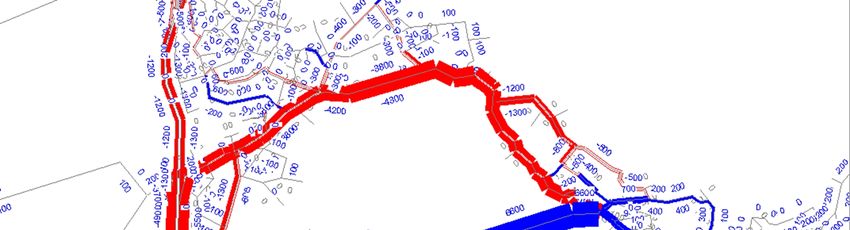
Figure 3-2 - AM Peak Comparison of 2013 Peak Period Flows
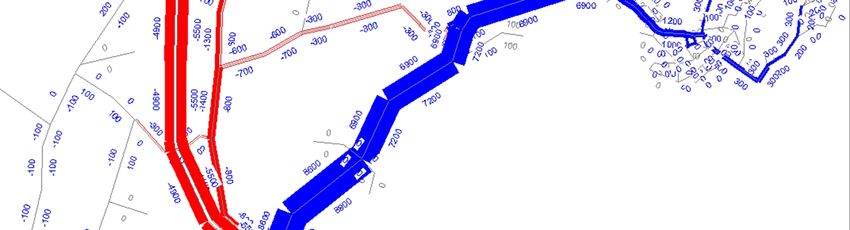
Figure 3-3 - Inter Peak Comparison of 2013 Peak Period Flows
Beca // 30 June 2014 // Page 11
3818713 // NZ1-9185925-10 4.0PENLINK Traffic and Economic Analysis
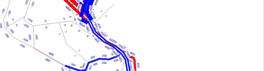
Figure 3-4 - PM Peak Comparison of 2013 Peak Period Flows
Turn Counts
The model was compared against turning count data collected at 6 intersections. The data
collected was a mixture of surveyed data and SCATS data at the following intersections:
n Dairy Flat Highway, northbound off-ramp roundabout (survey data)
n Hibiscus Coast Highway, southbound on/off roundabout (survey data)
n East Coast Road/Hibiscus Coast Highway intersection (survey data)
n Whangaparaoa Road/Hibiscus Coast Highway intersection (SACTS data)
n Red Beach Road/Whangaparaoa Road intersection (SCATS data)
n Whangaparaoa Road/Vipond Road intersection (SCATS data)
Table 3-4 displays the statistics for AM, inter and PM peaks, with a more detailed count comparison
found in Appendix D. The EEM does not have GEH targets for turn count comparisons, so the link
count targets were used as a guide.
Table 3-4 – Turn Count Comparison
Measure Target AM IP PM
GEHPENLINK Traffic and Economic Analysis
Table 3-4 shows that the model reached a reasonable level of fit for the turning counts. The AM
and interpeak counts that did not reach the GEH criteria are SCATS collected data which is not
thought to be as robust as the surveyed data. It is therefore is considered appropriate for the
purpose of the Penlink study.
Figure 3-5 – Figure 3-7 show the peak period comparisons.
Figure 3-5 - AM Peak Link flow Comparison of 2013 Peak Period Flows
Figure 3-6 - Inter Peak Link flow Comparison of 2013 Peak Period Flows
Beca // 30 June 2014 // Page 13
3818713 // NZ1-9185925-10 4.0PENLINK Traffic and Economic Analysis
Figure 3-7 - PM Peak Link flow Comparison of 2013 Peak Period Flows
3.5.2 Travel Time Comparison
Travel time comparisons were undertaken against observed data collected on the following five
routes:
n Stanmore Bay northbound to Hibiscus Coast Highway
n Hibiscus Coast Highway westbound to SH1 interchange
n SH1 Interchange southbound to Oteha Valley Road
n Oteha Valley Road northbound to Hibiscus Coast Highway off-ramp to Whangaparaoa Road
n Whangaparaoa Road southbound to Stanmore Bay
A comparison of the travel times between the observed and modelled data can be seen in Table
3-5, with distance-travel graphs found in Appendix E.
Table 3-5 shows that for the majority of routes the model is within the minimum and maximum of
the observed travel time data. In the AM and inter peaks, the model is slightly faster on SH1 than
the observed data.
Beca // 30 June 2014 // Page 14
3818713 // NZ1-9185925-10 4.0PENLINK Traffic and Economic Analysis
Table 3-5 - Travel Time Summary
Route Dir AM Inter Peak PM Peak
Min Mean Max Modelled Min Mean Max Modelled Min Mean Max Modelled
(obs) (obs) (obs) (obs) (obs) (obs) (obs) (obs) (obs)
Stanmore Bay to
Hibiscus Coast NB 9.09 10.13 12.15 11.03 8.00 8.30 8.62 9.13 9.75 10.07 10.38 9.21
Highway
Hibiscus Coast
Highway to Sh1 WB 1.98 2.70 3.79 2.46 2.27 2.72 3.69 2.11 1.83 2.05 2.33 2.11
interchange
SH1 Interchange
to Oteha Valley SB 8.90 9.49 10.00 8.32 7.98 8.32 8.65 8.04 8.08 8.56 8.90 8.02
Road
Oteha Valley
Road to Hibiscus
NB 8.52 8.79 9.48 7.95 8.32 8.62 8.92 8.04 9.50 10.30 11.10 11.02
Coast interchange
(end of off ramp)
Hibiscus Coast
Highway
interchange to EB 2.30 3.98 5.98 2.66 2.48 3.20 4.22 3.04 2.48 4.24 7.02 5.31
Whangaparaoa
Road
Whangaparaoa
Road to Stanmore SB 9.77 9.77 9.77 9.07 8.83 9.62 10.27 9.02 8.68 10.13 12.38 12.08
Bay
Beca // 30 June 2014 // Page 15
3818713 // NZ1-9185925-10 4.0You can also read