PERTH & KINROSS COUNCIL FLOOD RISK AND FLOOD RISK ASSESSMENTS - (DEVELOPERS GUIDANCE NOTE ON FLOODING & DRAINAGE) June 2014
←
→
Page content transcription
If your browser does not render page correctly, please read the page content below
PERTH & KINROSS COUNCIL

       FLOOD RISK AND FLOOD RISK
             ASSESSMENTS

(DEVELOPERS GUIDANCE NOTE ON FLOODING & DRAINAGE)

                    June 2014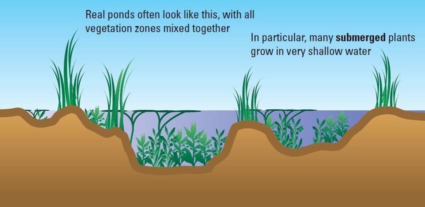
Perth & Kinross Council – Flood Risk and Flood Risk Assessments
                                     (Developers Guidance Note on Flooding and Drainage)

CONTENTS PAGE

1     INTRODUCTION ............................................................................................................................ 1
2     AIM ................................................................................................................................................. 1
3     BACKGROUND TO FLOODING ................................................................................................... 2
    3.1       Riparian Owner ...................................................................................................................... 2
    3.2       Legislation .............................................................................................................................. 2
    3.3       Role of Local Authority regarding Flooding and Drainage ..................................................... 3
    3.4       Types of Flooding ................................................................................................................... 3
    3.5       Flood Probability .................................................................................................................... 4
    3.6       Climate Change ..................................................................................................................... 5
4     DESIGN GUIDANCE ...................................................................................................................... 6
    4.2       Scottish Government .............................................................................................................. 6
    4.3       Scottish Environment Protection Agency (SEPA) .................................................................. 6
    4.4       SuDS Working Party .............................................................................................................. 6
    4.5       Construction Industry Research and Information Association (CIRIA) .................................. 6
    4.6       Scottish Water ........................................................................................................................ 7
    4.7       Other ...................................................................................................................................... 7
5     DRAINAGE IMPACT ASSESSMENT ............................................................................................ 8
    5.1       Introduction............................................................................................................................. 8
    5.2       Does the Development Require a DIA? ................................................................................. 8
    5.3       What Should a DIA Include .................................................................................................... 9
6     FLOOD RISK ASSESSMENT ...................................................................................................... 12
    6.1       When is a FRA Required? ................................................................................................... 12
    6.2       What Should a FRA Include? ............................................................................................... 13
    6.3       Can PKC Provide any Data for a FRA? ............................................................................... 15
7     SURFACE WATER DRAINAGE DESIGN ................................................................................... 16
    7.1       Introduction........................................................................................................................... 16
    7.2       Hydraulic Design .................................................................................................................. 16
    7.3       SuDS Design ........................................................................................................................ 16
    7.4       Soakaway Design ................................................................................................................ 19
    7.5       PKC Adoption Requirements for SuDS/Surface Water Drainage System .......................... 19
    7.6       Greenfield Runoff and Permissible Development Discharge Rates .................................... 20
8     FREQUENTLY ASKED QUESTIONS.......................................................................................... 23
    8.1       What return periods should I design to? .............................................................................. 23
    8.2       What allowance for climate change should I add? .............................................................. 23
    8.3       What are your freeboard levels? .......................................................................................... 23
    8.4       What are your Greenfield runoff rates? ................................................................................ 23
    8.5       Is there a minimum level to which I should design my bridge soffit? ................................... 23
    8.6       Is there a minimum and maximum gradient I can lay pipes to? ........................................... 23

                                                                                                                                                    I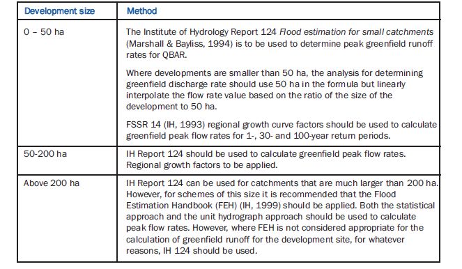
Perth & Kinross Council – Flood Risk and Flood Risk Assessments
                                    (Developers Guidance Note on Flooding and Drainage)

     8.7      Do you require electronic copies of my drainage/river modelling design? .......................... 24
     8.8      Is there a maximum gradient for SUDS embankments? ..................................................... 24
     8.9      I am building next to a watercourse; is a maintenance strip required? ................................ 24
     8.10     Can I develop land adjacent to an existing Flood Protection Scheme? .............................. 24
     8.11     How long does it take to process a FRA or DIA? ................................................................ 24
9      CERTIFICATION & INSURANCE ................................................................................................ 25
     9.1      Self Certification & Insurance ............................................................................................... 25
                rd
     9.2      3 Party Certification ............................................................................................................ 25
10     CONTACT DETAILS .................................................................................................................... 26
     10.1     Flooding Team ..................................................................................................................... 26
     10.2     Road Construction Consent Queries ................................................................................... 26
     10.3     Planning Queries (General) ................................................................................................. 26
11     GLOSSARY / ABBREVIATIONS ................................................................................................. 27

APPENDIX A – FRA CHECK SHEET .................................................................................................. 29
APPENDIX B - ASSESSMENT COMPLIANCE CERTIFICATION & INSURANCE ............................ 30

                                                                                                                                           II
Perth & Kinross Council – Flood Risk and Flood Risk Assessments
                            (Developers Guidance Note on Flooding and Drainage)

1 INTRODUCTION
1.1      Flooding is a natural phenomenon and many parts of Scotland have a legacy of development
at risk of flooding from watercourses, the sea, groundwater and inadequate drainage. Recent
research indicates that climate change will significantly increase the risk of flooding due to changes in
precipitation and rising sea levels. Already, since the mid 1980s, Scotland has seen an increase in the
number of floods and high flow levels on many rivers.

As a result of the increased risk of flooding, the Scottish Government has developed a policy over the
last ten years based on the principles of avoidance, awareness, assistance and alleviation. In June
2009, the Scottish Parliament enacted the Flood Risk Management (Scotland) Act to implement the
European Directive 2007/60/EC (the Flood Directive) and modernise flood risk management in
Scotland. The new Act provides the framework for a sustainable and risk based approach to flood risk
management considering flooding from all sources. In February 2010, the Scottish Government
published the Scottish Planning Policy (SPP) which combines and updates previously separate
planning policies, including SPP7 (Planning and Flooding). This provides a national framework on
which Perth and Kinross planning policy is based. A revised 2013 version of the Scottish Planning
Policy is currently being prepared and will shortly replace the 2010 version.

This supplementary guidance document on flooding & drainage has been prepared by Perth & Kinross
Council (PKC) Flooding Team to inform developers, their consultants and all stakeholders involved in
the planning process in relation to flooding and drainage about the requirements of PKC. It is based
on other existing legislation, planning policy, and technical guidance. Compliance with the guidance
will serve to meet the requirements of SPP, the Council’s Local Development Plan and assist in the
efficient processing of a developers’ application.

2 AIM
2.1       This guidance document is intended as supplementary guidance for the area of Perth and
Kinross in respect of existing national legislation and guidance regarding flooding and drainage (see
list in Section 4). It also aims to encourage an increased awareness, understanding and knowledge in
flooding and drainage issues of everyone involved in the development process and thus make Perth
and Kinross a safer place to live, work and visit.

This guidance document is not intended to replace the consultation that developers will require to
initiate with PKC Flooding Team and other consultees. Therefore, before submitting a planning
application, developers are strongly advised to consult with the Council’s Flooding Team and SEPA.
The Council holds information on historic flooding, flood studies, flood schemes, watercourse
maintenance records, biennial flood prevention reports, etc with relevant information on flooding within
Perth and Kinross.

                                                                                                   1
Perth & Kinross Council – Flood Risk and Flood Risk Assessments
(Developers Guidance Note on Flooding and Drainage)
3 BACKGROUND TO FLOODING
3.1 Riparian Owner
3.1.1 Flooding is a natural phenomenon and as such the main responsibility for reducing flood risk
lies with the owner of the affected property. It is long established that a property owner should take
responsibility for the safety and security of his/her own property, which includes a right to take steps to
reduce the risk of flooding.
3.1.2 Under Common Law riparian owners must:
Accept water from upstream;
Have the right to protect own property;
Should not make the situation (flooding) worse for others;
Undertake maintenance of watercourses on their property.
3.2 Legislation
3.2.1 There are many pieces of legislation covering flooding and drainage. A general summary is
outlined below:
3.2.2 Flood Risk Management (Scotland) Act 2009
The Scottish Parliament enacted the Flood Risk Management (Scotland) Act 2009 to implement the
European Directive 2007/60/EC (the Flood Directive) and modernise flood risk management in
Scotland. The new Act provides the framework for sustainable and risk based approach to flood risk
management considering flooding from all sources. The new Act identifies the roles and functions of
the responsible parties with a view to reducing overall flood risk.
The main roles and responsibilities for PKC under the Act are:
Map bodies of water and Sustainable Drainage Systems;
Assess bodies of water from time to time for the purpose of ascertaining whether the
condition of any such body of water gives rise to a risk of flooding of land within or
outwith its area;
Where a body of water gives rise to such a risk, the authority shall prepare and carry
out a schedule of clearance and repair works;
Prepare local flood risk management plans.
3.2.3 Scottish Planning Policy (SPP)
Scottish Planning Policy (SPP) is a statement of Scottish Government policy on land use planning and
provides a national framework on which Perth and Kinross planning policy is based. In particular, SPP
states planning authorities must consider flooding from all sources and the risks involved when
preparing development plans and determining planning applications. A revised 2013 version of the
Scottish Planning Policy is currently out to consultation and will shortly replace the 2010 version.
3.2.4 Water Environment Water Services (Scotland) Act 2003 (WEWS Act)
The WEWS Act gave Scottish Ministers powers to introduce regulatory controls over water activities,
in order to protect, improve and promote sustainable use of Scotland’s water environment. This
includes wetlands, rivers, lochs, transitional waters (estuaries), coastal waters and groundwater.
2Perth & Kinross Council – Flood Risk and Flood Risk Assessments
(Developers Guidance Note on Flooding and Drainage)
3.2.5 Controlled Activities (Scotland) Regulations 2011
These regulations are more commonly known as the Controlled Activity Regulations (CAR).
If you intend to carry out any activity which may affect Scotland’s water environment, you must be
authorised by SEPA to do so.
3.3 Role of Local Authority regarding Flooding and Drainage
3.3.1 Roads Authority
The Roads (Scotland) Act 1984 gives local authorities powers and duties with regards to public roads.
Of particular relevance are:
Manage and maintain all roads in their area which includes draining roads and
keeping drains clear;
Contribute towards the costs of drainage works which appear to them desirable for
protection or enjoyment of a public road;
There is a duty on owners and occupiers of land adjacent to a road to prevent water
or dirt from flowing onto or across the public road.
3.3.2 Flood Authority
PKC have duties and powers to reduce flood risk in their area. The Flood Risk Management
(Scotland) Act 2009, detailed in Section 3.2.2, outlines the duties of the Local Authority.
However, flooding is a natural phenomenon and as such the main responsibility for reducing flood risk
lies with the owner of the affected property.
3.3.3 Planning Authority
The planning system is used to make decisions about future development, and the use of land in our
towns, cities and countryside. It decides where development should happen, where it should not and
how development affects its surroundings. PKC, as Planning Authority, have a role in checking the
adequacy or otherwise of a development in terms of flooding from all sources (i.e. Surface Water,
Fluvial Flooding, Groundwater) and inform the Developer when a FRA/DIA is required. SPP provides
the framework in which to carry out these duties, refer to Section 3.2.3.
1
3.4 Types of Flooding
3.4.1 Developers will need to consider all sources of flooding when assessing flood risk at a site.
The various types of flooding are generally defined as follows:
3.4.2 Fluvial – flooding originating from a watercourse either natural or culverted. Normally caused
when the river channel capacity (or culvert capacity) is exceeded and water flows out-of-bank
onto the floodplain, which could either be natural floodplain or developed. A floodplain is the
area(s) of land adjacent to a watercourse where floodwaters naturally flow and/or are stored
during times of flood. In some instances fluvial flooding can occur from a combination of
several local watercourses.
3.4.3 Coastal – flooding originating from the sea (open coast or estuary) where water levels exceed
the normal tidal range and flood onto the low-lying areas that define the coast line. This
coastal plain could be either natural or developed. Coastal flooding can occur due to four
physical elements (as outlined below) either acting on their own or in combination with each
other.
1
SEPA – Technical Flood Risk Guidance for Stakeholders
3Perth & Kinross Council – Flood Risk and Flood Risk Assessments
(Developers Guidance Note on Flooding and Drainage)
Predicted astronomical tide: expected sea level due to the gravitational effects of
the sun and the moon.
Storm surge residual: elevated sea level caused by the combined effect of low
pressure and persistent, strong wind (for every millibar drop in pressure, a 10mm rise
in the sea surface elevation occurs).
Wave effects: a function of both wind strength and open water ‘fetch’ length. As a
result of high winds, waves can also be associated with low pressure systems which
cause storm surge effects as described above.
Local bathymetric effects: topographic funnelling due to the forcing of a large
volume of open sea water into a restricted coastal embayment, e.g. estuary (Firth of
Forth), tidal basin (Montrose Basin) or sea loch (Loch Fyne), which will elevate water
levels locally.
3.4.4 Pluvial – urban or rural flooding which results from rainfall-generated overland flow before the
runoff enters any watercourse, drainage system or sewer.
3.4.5 Groundwater – flooding due to a significant rise in the water table, normally as a result of
prolonged and heavy rainfall over a sustained period of time (can affect cellars and drainage
systems). Normally associated with catchments where porous substrate and/or aquifers exist.
This type of flooding can last for a considerable period of time, i.e. weeks, months.
3.4.6 Drainage – flooding as a result of surcharging of man-made drainage systems including
combined sewers where the capacity of the system to convey runoff has been exceeded.
3.4.7 Infrastructure Failure – flooding due to collapse/failure of man made infrastructure including
hydro-dams, water supply reservoirs (private or public), canals, flood defence structures,
underground conduits (e.g. sewers) and water treatment tanks.
3.4.8 Note that flooding may occur due to a combination of more than one type of flood process (i.e.
fluvial and coastal flooding). In these circumstances please contact the Flooding Team to
discuss the implications and any additional work required.
3.5 Flood Probability
3.5.1 The annual probability (AP) of flooding is the statistical chance (or risk) that a location will
flood in any given year and relates to a particular size or magnitude of flood, e.g. the 0.5% AP (200-
year) flood event is smaller in size than the 0.1% AP (1000-year) flood event (although a 0.5% AP
flood event will occur more frequently than a 0.1% AP flood event).
3.5.2 For any given location, the 0.5% AP (200-year) flood event should (in theory) affect a smaller
spatial area, or, will inundate the same area to a lesser depth (if the floodplain is constricted by
topography), than the larger 0.1% AP (1000-year) flood event. The chance of experiencing the larger
0.1% AP flood event, however, is smaller as explained below:
3.5.3 For the same location, the 0.5% AP flood event can be expressed as ‘the flood which has a
0.5% chance of occurring in any given year’ (i.e. there is a 1 in 200 chance of experiencing a flood of
that size, at that location); also referred to as the 200-year flood or the flood with a return period of
200-years.
3.5.4 However, it does not follow that if a location suffers the 0.5% AP flood event this year, it will
not be flooded again to this extent for 199 years. Statistically, the chance or probability of
experiencing the 0.5% AP flood event remains the same in any given year. Furthermore, it also does
not follow that over any 200-year period, the 0.5% AP (200-year) flood event will definitely be
experienced, i.e. statistically, the chance of experiencing the 200-year flood event within a 200-year
period is only 63% (see table 1 below).
4Perth & Kinross Council – Flood Risk and Flood Risk Assessments
(Developers Guidance Note on Flooding and Drainage)
Table 1: Probability of experiencing a range of flood events over different time periods (design life)
3.5.5 Flooding is likely to increase due to climate change. In general terms this is likely to result in
an increased probability of occurrence of extreme storm event. However the concept of flood
probability is generally based on stationary process and therefore does not take into account climate
change directly. Hence there is a need to add an allowance for the impact of climate change as
detailed below.
3.6 Climate Change
3.6.1 Climate change is happening and there is mounting evidence of fundamental alterations to the
key elements of our climate system as a result of human activities. Left unchecked these changes will
accelerate, with significant consequences for our environment, economy and society.
3.6.2 The pace and signs of climate change varies across the globe, but eventually everyone will
either be directly or indirectly affected by climate change. Flooding and drought are obvious direct
threats, and these can have indirect impacts such as higher food prices as a result of crop damage.
3.6.3 In Scotland, climate change is evident from observed changes in temperature, rainfall and
snow cover. These changes are causing significant shifts in the growing, breeding and migration
seasons, as well as species abundance and diversity. Higher river flows are leading to flood risks and
sea level rise is causing coastal erosion.
3.6.4 Left unchecked, climate change will accelerate. Therefore, developers must aim to reduce
and account for the affects of climate change in order to minimise the burden for future generations.
5Perth & Kinross Council – Flood Risk and Flood Risk Assessments
(Developers Guidance Note on Flooding and Drainage)
4 DESIGN GUIDANCE
4.1 This section lists the main national legislation and technical guidance that PKC expects
developers and their consultants to follow when preparing a Drainage Impact Assessment (DIA),
Flood Risk Assessment (FRA), design of Sustainable Drainage Systems (SuDS) and other drainage
infrastructures. The list below is not exhaustive, and developers must ensure that all guidance and
other relevant documentation is clearly referenced in their submissions.
Many of these documents are subject to frequent revision, and developers should ensure that they are
using the current versions.
4.2 Scottish Government
Flood Risk Management (Scotland) Act 2009
Scottish Planning Policy, February 2010 – (2013 update due out soon)
Planning Advice Note 51: Planning, Environmental Protection and Regulation
2
Planning Advice Note 61: Planning and Sustainable Urban Drainage Systems
2
Planning Advice Note 69: Planning and Building Standards Advice on Flooding
2
Planning Advice Note 79: Water and Drainage
The Water Environment and Water Services (Scotland) Act 2003
The Water Environment (Controlled Activities) (Scotland) Regulations 2011
Roads (Scotland) Act 1984
Planning etc (Scotland) Act 2006
Delivering Sustainable Flood Risk Management
Surface Water Management Planning Guidance
4.3 Scottish Environment Protection Agency (SEPA)
SEPA Policy No 41: Development at Risk of Flooding: Advice and Consultation
SEPA Ponds, Pools and Lochans – Guidance on the Good Practise in the Management
and Creation of Small Waterbodies in Scotland
SEPA Technical Flood Risk Guidance for Stakeholders
SEPA’s Indicative River and Coastal Flood Map
Various SEPA policy documents for water, water resources, flooding and climate
change
SEPA advice on Sustainable Drainage Systems (SuDS)
And other general SEPA surface water drainage guidance available
Habitat Enhancement Publications
Land Use Vulnerability Guidance
4.4 SuDS Working Party
Drainage Assessment: A Guide for Scotland
4.5 Construction Industry Research and Information Association (CIRIA)
CIRIA C532: Control of Water Pollution form Construction Sites – Guidance for
Consultants and Contractors
CIRIA C582: Source Control using Constructed Pervious Surfaces. Hydraulic, Structural
and Water Quality Performance Issues
CIRIA C624: Development and Flood Risk – Guidance for the Construction Industry
CIRIA C625: Model Agreements for Sustainable Water Management Systems
CIRIA C635: Designing for Exceedance in Urban Drainage – Good Practice
CIRIA C680: Structural Designs of Modular Geocellular Drainage Tanks
CIRIA C687: Planning for SuDS – Making it happen
CIRIA C688: Flood Resilience and Resistance for Critical Infrastructure
CIRIA C689: Culvert Design and Operation Guide
2
Note: Planning Advice Note 61, 69 and 79 are in the process of being amalgamated into one document.
6Perth & Kinross Council – Flood Risk and Flood Risk Assessments
(Developers Guidance Note on Flooding and Drainage)
CIRIA C697: SuDS Manual
CIRIA C698: Site Handbook for the Construction of SuDS
CIRIA C713 Retrofitting to Manage Surface Water
CIRIA C715: Environmental Good Practice on Site – Pocket Book
CIRIA C724: Creating Water Sensitive Places
CIRIA R156: Infiltration Drainage – Manual of Good Practice
4.6 Scottish Water
nd
Sewers for Scotland 2 Edition
4.7 Other
BRE Digest 365
DEFRA – Flood Risk Assessment Guidance for New Development
UKCP09
DEFRA FCDPAG3 October 2006 Supplementary Note on Climate Change Impacts
TAYplan
Perth and Kinross Local Development Plan
BS EN 1610:1998 Construction and Testing of Drains and Sewers
Institute of Hydrology Report 124
Flood Estimation Handbook
SuDS for Roads
7Perth & Kinross Council – Flood Risk and Flood Risk Assessments
(Developers Guidance Note on Flooding and Drainage)
5 DRAINAGE IMPACT ASSESSMENT
5.1 Introduction
5.1.1 This section provides guidance on the requirements for the preparation and submission of a
DIA for new developments.
5.1.2 Drainage is a material consideration at the planning stage of a development and due
consideration must be given to the impact of the proposed development on the catchment area. This
includes an assessment of potential for both flood risk and pollution.
5.1.3 Submission of a DIA with all the information required will accelerate consideration of the
planning application. Failure to demonstrate that satisfactory means of waste water and/or surface
water drainage can be provided may lead to refusal of planning permission.
5.1.4 A DIA is site specific and should deal with waste water and surface water drainage. The latter
should be drained according to the principles of SuDS, refer to Section 7.
5.1.5 Where the development is to be phased, constructed at different stages or by different
developers, a strategic drainage plan covering the whole area of the development should be submitted
at outline planning stage.
5.1.6 Where the development will lead to the production of waste water, a DIA must include a
section on waste water.
5.2 Does the Development Require a DIA?
5.2.1 Most developments will require a DIA to be submitted as part of the planning process. The
extent of a DIA will be dependant on the size and complexity of the Development. For large
developments where there is an intention to separate the development into zones which will potentially
be constructed at different stages or by different developers, a drainage masterplan covering the
whole of the development will be required.
5.2.2 The following categories of development will not require a DIA, but the best available option
for waste water and surface water drainage is expected to be demonstrated.
2
1. Developments with a total proposed impermeable surface area of less than 1000m unless the
development may affect sensitive areas*;
2. Extension of building or hardstanding area under 100 square metres;
3. Changes of use not involving new buildings or hard surfacing;
4. Where the submission forms part of a larger development for which a DIA has already been
accepted.
*Sensitive Areas include:
a. Areas where there is no available public sewer;
b. Areas affected by flooding;
c. Areas with high water table problems;
d. Receiving water with no capacity for additional flow (e.g. Perth Town Lade);
e. Areas surrounding Fisheries i.e. local fish farms;
f. Areas with or upstream (1km) of a conservation site designated under national or
international legislation, for example a Site of Special Scientific Interest (SSSI); and
g. Contaminated Land.
5.2.3 In the event that you are unsure as to whether a DIA is required or whether your development
affects any of the sensitive areas please contact the Flooding Team for clarification, refer to Section
10 for contact details.
8Perth & Kinross Council – Flood Risk and Flood Risk Assessments
(Developers Guidance Note on Flooding and Drainage)
5.3 What Should a DIA Include
5.3.1 Planning Permission In Principle
Planning Permission in Principle will require a brief overview of the development site drainage
arrangements, associated issues and include the following:
i. Drawings showing the development site in relation to the natural surface water
runoff catchment or sub-catchment areas, including contour plans and details of
the existing receiving watercourses and surface water drainage.
ii. A statement identifying which, if any, of the receiving drains and watercourses are
historically prone to flooding in any part of their length.
iii. Sufficient information on the restriction of post development surface water forward
flow, basic catchment areas, pervious and impervious areas ratio, proposed
methods of attenuation and indicative SuDS details, in order that a Strategic
Drainage Plan or a local drainage proposal can be agreed in principle.
iv. Completed Appendix B.
5.3.2 Full Planning Applications
A full DIA should include all information relating to the design, construction, operation and
maintenance of the drainage infrastructure. In particular:
5.3.3 Background Data
1. Background to the existing drainage infrastructure, including a drawing (1:1250)
detailing the size, percentage of impermeable area, type, level and rough gradient
of each drainage infrastructure (field drains should be incorporated where
possible). Photographs are recommended to record details of key site
features/water related structures (bridges, culverts, riverbanks, ditches, ponds,
existing flood protection measures, existing SuDS, etc) and provide an
assessment of their condition;
2. A brief summary of how the drainage design provides SuDS techniques in
accordance with current design guidance;
5.3.4 Supporting Text
1. The size of the Development and percentage of impervious surfaces (including an
additional 10% for future expansion);
2. The soil classification for the site including test results and, specifically, details of
any site contamination;
3. Subsoil porosity test for proposed infiltration devices should be undertaken in line
with the requirements of BRE Digest 365 or similar recognised methodology (to
be confirmed by the Developer). Note, subsoil porosity tests must be undertaken
as close as possible to the proposed location of each proposed infiltration
device/component to ensure that the results are representative. If a porosity test
is deemed by PKC to be too remote from the proposed location, the test may
require to be re-done;
4. Summary of SuDS to be incorporated and how the system will perform and
operate including suitability (or not) for future development connections. The
summary of SuDS should include comment on the interaction with any
contaminated soil present on the site during the construction and operation of the
SuDS;
5. Assessment of flood risk including consideration of the overland flow route back to
the receiving watercourse for up to the 0.5% AP (200-year) plus climate change
flood event showing no detriment to land or property as a result of overland flow.
The 0.5% AP (200-year) plus climate change flood event must be a minimum of
9Perth & Kinross Council – Flood Risk and Flood Risk Assessments
(Developers Guidance Note on Flooding and Drainage)
3
300mm from the lowest garden ground level and 600mm from property finished
floor levels (FFL);
6. A method statement detailing how water arising during construction will be dealt
with (refer CIRIA publication C532 Control of water pollution form construction
sites. Guidance for consultants and contractors), with particular reference to
erosion prevention, sediment and runoff control and pollution prevention in order
to ensure the integrity and satisfactory performance of SuDS. The use of
completed SuDS for this purpose will not be accepted;
7. Copies of plans from Scottish Water confirming the location of the nearest public
sewers and signed correspondence confirming their availability for servicing the
development. This shall clearly state agreed flow rates for waste water and
surface water as applicable;
8. A copy of a letter from SEPA outlining their approval of the design flows for the
watercourse(s) being considered;
4
5.3.5 Calculations
1. Drainage network calculations for various durations (minimum of 15, 30, 60, 120,
240, 360, 480, 960, 1440min) at the following return periods 1-year, 30-year, 100-
year and 200-year;
2. Calculations demonstrating the attenuation required so that the post-development
run-off volume does not exceed that for pre-development for the critical rainfall
events (refer to Section 7.6);
3. Calculations demonstrating the pre development peak run-off flow rate for the
critical rainfall event for 3.33% AP (30-year), 1% AP (100-year) and 0.5% AP
(200-year) and for post development peak run-off flow rate for the critical rainfall
event for 3.33% AP (30-year), 1% AP (100-year) and 0.5% AP (200-year),
including 20% for climate change (e.g. post development for 0.5% AP (200-year)
with CC to be attenuated to pre development for 0.5% AP (200-year) without CC).
If using software, a CD containing all input and results files with a word document
summarising the contents of each file should be included;
4. Calculation of the treatment volume (Vt) and required multiples thereof and
demonstration that the level of treatment and available treatment volume in the
SuDS is adequate. Swales as conveyance systems contribute to the total V t;
5. Calculations for the outlet control for attenuation structures and/or SuDS
treatment facilities, along with manufacturers’ data for proprietary controls;
6. To aid review and understanding, all calculations should be suitably annotated to
provide descriptive text of the logic, reasoning and methodology utilised. The
origin of all formulae should be identified. All assumptions should be clearly
stated with reference to their origin. All units should be clearly stated;
5.3.6 Drawings
1. Detailed scale drawing/s showing the development proposals at a scale of
1:1250;
2. Detailed scale drawing/s showing the development waste water and surface water
drainage proposals at a scale of 1:1250 or 1:500 where complex;
5.3.7 Maintenance
1. Details of in principle maintenance responsibilities including copies of relevant
correspondence. Responsibility for maintenance of SuDS within property
boundaries rests with the property owner. Developers shall provide confirmation
3
It is acknowledged that in certain circumstances 300mm freeboard for garden ground may not be achievable and early
consultation and agreement with the Flooding Team is recommended.
4
It is acknowledged that the requirement for fully detailed drainage calculations (Section 5.3.5) at full planning application stage
is not always appropriate. Therefore, the developer should approach the Flooding Team to discuss the level of detail required
to properly assess the application. Outline design calculations will be required as a minimum.
10Perth & Kinross Council – Flood Risk and Flood Risk Assessments
(Developers Guidance Note on Flooding and Drainage)
on how they intend to make homeowners aware of the burden of responsibility
and whether there will be an allowance for setting up factoring arrangements to
manage maintenance;
2. A maintenance schedule for all proposed SuDS, to include a detailed list of
activities and timescales;
5.3.8 Health & Safety
1. Risk assessments for SuDS facilities and attenuation structures which have
permanent or temporary opening and a water of a depth that could pose a risk to
health and safety.
5.3.9 General
1. All documents, drawings and calculations should clearly state a reference title,
number and version to ensure that appropriate version control is applied and to
provide ease of reference through any subsequent necessary revisions. All
documents, drawings and calculations should show evidence of appropriate
check, review and approval prior to issue;
2. All levels should be related to Ordnance Datum Newlyn;
3. Completed Appendix B.
Please note, this list is not exhaustive and additional information maybe requested as required.
5.3.10
IMPORTANT INFORMATION
In the event that the Development is approved, the Flooding Team require a copy of the Health
& Safety File on completion of the Maintenance Period. The Health & Safety File should
incorporate as a minimum:
1. Risk assessments
2. Maintenance schedules
3. Up to date full CCTV survey of system
4. As-Built drawings
5. Maintenance procedures
The above information is required in order that PKC can comply with the Flood Risk
Management (Scotland) Act 2009.
Failure to provide the above information may delay or prevent the adoption of your
development.
11Perth & Kinross Council – Flood Risk and Flood Risk Assessments
(Developers Guidance Note on Flooding and Drainage)
6 FLOOD RISK ASSESSMENT
6.1 When is a FRA Required?
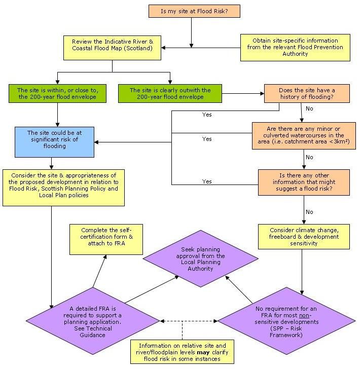
6.1.1 Flooding is a material consideration at the planning stage of a development and is required
from the outset (i.e. at planning permission in-principle stage). The Flood Risk and Planning Flow
Chart, see Figure 1 below, illustrates when a FRA is required. Should a developer be unclear as to
whether a FRA is required, then contact should be made with the Flooding Team for clarification, refer
to Section 10.
6.1.2 In addition, a FRA is also required in the following circumstances:
1. Construction of a new watercourse;
2. Construction of a structure over or adjacent to a watercourse;
3. Development in or adjacent to a flood bank or any flood control structure or constraint;
4. Construction adjacent to Coastal waters and/or below the 6m mAOD contour.
6.1.3
Figure 1 – http://www.sepa.org.uk/flooding/flood_risk/planning__flooding/flow_chart.aspx
12Perth & Kinross Council – Flood Risk and Flood Risk Assessments
(Developers Guidance Note on Flooding and Drainage)
6.2 What Should a FRA Include?
6.2.1 PKC endorses technical guidance provided by SEPA and will require developers to strictly
adhere to them. The detail and technical complexity of a Flood Risk Assessment will be proportionate
to the scale and potential significance of the development but, in all cases, it should comply with the
requirements of SEPA’s Technical Flood Risk Guidance for Stakeholders – current version.
Additional PKC requirements for a FRA are outlined below:
6.2.2 Climate Change
In accordance with recent DEFRA research, PKC require a climate change (CC)
allowance (a 20% increase in the estimated peak flow) to be applied to the 0.5% AP
(200-year).
6.2.3 Freeboard
Freeboard is an allowance in height above the predicted level of a flood to take
account of the height of any waves or turbulence and the uncertainty in estimating the
probability of flooding. PKC apply the following requirements for Freeboard:
Finished Floor Levels (FFL) must be a minimum of 600mm above the 0.5%
AP (200-year) design flood level (the design flood level must include 20% for
CC).
Lowest garden ground level must be a minimum of 300mm above the 0.5%
AP (200-year) design flood level (the design flood level must include 20% for
5
CC).
6.2.4 Critical Infrastructure
Most developments will be required to model up to the 0.5% AP (200-year) return
period. However, where developments are regarded as critical infrastructure, under
SPP, they will be required to model up to, and be out with, the 0.1%AP (1000-year)
flood plain.
6.2.5 Sensitivity Analysis
The Flooding Team expect an appropriate sensitivity analysis should be carried out to
determine the sensitivity of the design water levels to key model parameters. A
sensitivity analysis will include the following parameters and the appropriate figures to
be used will be dependant on the site characteristics and the quality of data used:
Peak Flow;
Manning’s Roughness;
Blockage to all obstructions (where applicable);
Upstream/Downstream Boundary Conditions (where applicable).
6.2.6 Safe Access/Egress
Any new development must incorporate safe access/egress for pedestrians and
vehicular traffic within the development site. This should take account of flooding
from all sources such as the predicted 0.5% AP (200-year) including climate change
flood envelope and overland flood routes from within and external to the site.
5
It is acknowledged that in certain circumstances 300mm freeboard for garden ground may not be achievable and early
consultation and agreement with the Flooding Team is recommended.
13Perth & Kinross Council – Flood Risk and Flood Risk Assessments
(Developers Guidance Note on Flooding and Drainage)
6.2.7 Coastal Areas
The FRA requirements for coastal developments differ from inland developments and
should be discussed with the Flooding Team at the earliest opportunity.
6.2.8 Provision of Calculations and Modelling data
When submitting a FRA an electronic copy of the modelling results and supporting
information shall be submitted using E-mail, Compact Disc (CD) or USB pen drive.
The FRA should contain the following information:
All data and modelling results files for each of the modelled scenarios: 50%
AP (2-year), 2% AP (50-year), 1% AP (100-year), 0.5% AP (200-year), 0.5%
AP (200-year) including 20% for CC, pre and post development. If critical
infrastructure, the 0.1% AP (1000-year) scenario should also be included
This information should be in both raw data form and expressed in map form;
Proposals and calculations for compensatory storage or flood mitigation
measures to deal with the assessed post development increase in flooding
on the site and elsewhere (where required);
Rainfall data (where required);
Gauging station data (where required);
Catchment descriptors;
Other supporting information;
A word document containing a summary of the methodology behind the
model; and
Brief summary of each electronic file, where required (i.e. modelling files).
6.2.9 Background Data
Good use of photographs is recommended to record details of key site features.
Information should be provided to identify the ownership of any water related
structures and an assessment of their condition.
6.2.10 Submission of a FRA
A FRA shall be submitted in paper and electronic format as detailed below:
Papercopy:
FRA
All associated correspondence
Completed Appendix A
Completed Appendix B
Compact Disk or USB device containing:
FRA*
All Associated correspondence*
Completed Appendix A*
Completed Appendix B*
Complete Hec-ras, Infoworks, Mike 11, ISIS, Windes etc modelling results and word
document summarising methodology and file documentation.
*Acceptable formats are .pdf, .xls, .doc.
14Perth & Kinross Council – Flood Risk and Flood Risk Assessments
(Developers Guidance Note on Flooding and Drainage)
Failure to enclose any of the above documentation will prolong the assessment
process.
6.3 Can PKC Provide any Data for a FRA?
6.3.1 Yes, depending on the location of your development, PKC can, subject to availability, provide
the following information:
Historical Flood Records – PKC publishes a biennial report which specifies the measures
required, and the measures taken, to mitigate flooding of land in their area and all occurrences
of flooding. The latest biennial report can be requested by contacting the Flooding Team;
6,7
Completed Flood Studies – PKC are currently undertaking or have completed a number of
flood studies in known flood risk areas such as Almondbank, Alyth, Bankfoot, Birnam,
Burrelton, Comrie/Dalginross, Coupar Angus, Dalguise, Dunkeld, Greenloaning, Inchyra
(quick appraisal), Invergowrie, South Kinross, Logierait, Longforgan, Meikleour, Pitlochry and
Scone.
6
Flood Prevention Schemes – PKC hold records of flood prevention measures constructed
in Perth, Bridge of Earn, Milnathort, Comrie and Weem.
6.3.2 It should be noted that SEPA also hold historic flood risk information and monitor river levels
and flows throughout Perth & Kinross which can help in the assessment of flood risk.
6
Please contact a member of the Flooding Team for an updated list of ongoing/completed flood studies/schemes
7
Please note that a number of these studies were completed over 5 years ago and the developer should (in consultation with
the Flooding Team) review the information to determine if further assessment is required.
15Perth & Kinross Council – Flood Risk and Flood Risk Assessments
(Developers Guidance Note on Flooding and Drainage)
7 SURFACE WATER DRAINAGE DESIGN
7.1 Introduction
7.1.1 Under the Water Environment (Controlled Activities) (Scotland) Regulations 2011 surface
water drainage must be discharge by means of a SuDS (there are exceptions for single house
dwellings or discharges to coastal waters). The SuDS shall avoid pollution of the environment and
attenuate flows to Greenfield runoff levels (refer to Section 7.6).
7.2 Hydraulic Design
7.2.1 The hydraulic design of surface water drainage systems (and SuDS), to be adopted by PKC,
should meet the following criteria:
The surface water system should be designed so that the system does not surcharge during
3.33% (30-year) flood event.
The surface water system should be designed such that the system may surcharge but not
flood properties or garden ground during a 1% AP (100-year) flood event.
The surface water system should be designed so that should flooding occur during a 0.5% AP
(200-year) flood event + 20% Climate Change, it should not encroach within 300mm of the
8
lowest garden ground level or 600mm of property FFL. The overland flow route shall be
defined until a suitable conclusion to a receiving watercourse or suitable drainage system. In
addition, access and egress must be maintained at all times during the event.
The discharge rate from the development shall be restricted to the pre-development
Greenfield runoff for the equivalent return period (or as agreed with the Flooding Team).
Refer to Section 7.6.
Note: PKC would prefer the SUDS system to attenuate up to the 0.5% AP (200-year) flood event +
20% climate change in order that adjacent development zones are not blighted by overland flow
routes.
7.3 SuDS Design
7.3.1 SuDS design should be in accordance with the most up to date CIRIA guidance.
Maintenance of SuDS is essential if they are to perform properly and not themselves pose a risk of
flooding. It is essential that proposals for ownership/adoption and arrangements and responsibilities
for future maintenance of all parts of the system are documented in the design submission.
Early discussion between the Developer, PKC, Scottish Water and SEPA should be initiated when
designing SuDS for a development. Where SuDS are being designed on the basis that they are to be
vested by Scottish Water, the Developer shall ensure that the design is in accordance with Sewers for
nd
Scotland, 2 Edition. Where the Developer intends to request that PKC adopt/vest a SuDS feature,
early discussion with PKC should be held to explore the potential for such an agreement. In these
circumstances, an agreement to provide a commuted sum towards the cost of maintenance may be
expected from the Developer before Planning Permission is granted.
Responsibility for maintenance of SuDS within property boundaries rests with the property owner.
Developers must make homeowners aware of the burden of responsibility and should investigate
setting up factoring arrangements to manage maintenance.
Submission of your surface water drainage design should always include a signed version of Appendix
B.
Other relevant guidance specific to SuDS is outlined in the following sections:
8
It is acknowledged that in certain circumstances 300mm freeboard for garden ground may not be achievable and early
consultation and agreement with the Flooding Team is recommended.
16Perth & Kinross Council – Flood Risk and Flood Risk Assessments
(Developers Guidance Note on Flooding and Drainage)
7.3.2 Embankment Gradients
SuDS Embankment gradients shall be a maximum of 1:4 in order to allow
safe egress/aggress.
7.3.3 Flood Flow Routes
Where the design of a SuDS shows the system will overtop during a 0.5% AP
(200-year) flood event including climate change, the flood flow routes shall be
determined. Where they approach property and/or garden thresholds, the
routes should be manipulated to divert the flood water to locations that cause
the minimal interference. A plan detailing the flood routes should be included
with the planning application where required. The plan shall clearly identify
where overland flow originating from within the development site has the
potential to impact upon adjacent land or properties outwith the development
boundary until it reaches a suitable conclusion into a receiving watercourse or
appropriate drainage system.
7.3.4 Pond Layout & Location
Where possible a SuDS pond should be located adjacent to non-intensively
managed landscapes where natural sources of native species are likely to be
good. i.e. close to wetlands or natural ponds, lakes and river floodplains.
However, they must not be connected in order to prevent contamination.
The council will not accept any SuDS located within the 0.5% AP (200-year)
flood plain as during flood events the performance of the pond will be
compromised by flood water and could potentially lead to more extreme
flooding and pollution of the site.
A pond should create habitat mosaics with sub basins of permanent,
temporary and semi-permanent ponds: vary these in size and depth – see
figure 2 below. Ensure that some ponds, or parts of basins are not exposed
to the main pollutant burden allowing many more sensitive animals and plants
to exploit some parts of the site.
SuDS ponds should be designed to be open and accessible to residents and
the general public. Fencing of a SuDS pond should only be considered as a
last resort or where required by Scottish Water in order to agree vesting of the
asset.
Further information on the creation of a SuDS pond can be found in SEPA’s
2000 publication called Ponds, Pools and Lochans - guidance on good
practice in the management and creation of small waterbodies in Scotland.
17Perth & Kinross Council – Flood Risk and Flood Risk Assessments
(Developers Guidance Note on Flooding and Drainage)
Figure 2 – Pond layout (Ponds, Pools and Lochans, Guidance on good practice in the
management and creation of small waterbodies in Scotland, June 2000, SEPA)
7.3.5 Surface Water Systems to be adopted by Scottish Water
Where surface water drainage systems are to be adopted by Scottish Water
nd
they must be designed to Sewers for Scotland, 2 Edition. Currently, the
design criteria is 3.33% (30-year) event. As a result, the developer must
detail the flood flow routes for a 0.5% (200-year) flood event including climate
change, and how this will be managed on site in order that access and egress
is maintained at all times and the designed flood water level is a minimum of
9
600mm from FLL and 300mm from the lowest garden ground level . The
overland flow route shall be defined until a suitable conclusion to a receiving
watercourse or suitable drainage system.
7.3.6 Treatment Volume
Equation 1 should be submitted as part of the planning application. Refer to
Section 4.5 of CIRIA C697 ‘The SuDS manual’.
9
It is acknowledged that in certain circumstances 300mm freeboard for garden ground may not be achievable and early
consultation and agreement with the Flooding Team is recommended.
18Perth & Kinross Council – Flood Risk and Flood Risk Assessments
(Developers Guidance Note on Flooding and Drainage)
7.3.7 Trash Screens
All SuDS inlet headwalls shall feature a trash screen which includes an open
tread surface to facilitate easy access but also allow an alternative route for
water to flow should the face of the screen become blocked. Any pipe outlets
shall not be covered with a trash screen.
7.4 Soakaway Design
7.4.1 Soakaways should only be used for surface water disposal where it can be demonstrated that
the hydrological and hydrogeological conditions are suitable and the time for emptying will not be
excessive.
7.4.2 The design of surface water soakaways should be to the requirements of BRE Digest 365 or
CIRIA C697.
7.4.3 Soakaways should not be located within 5m of building foundations, nor in any position where
the ground below foundations is likely to be affected. In addition, soakaways must take account of
seasonal variations in the groundwater table.
7.4.4 Attention should be paid to the source of the runoff water to be collected and appropriate pre-
treatment facilities provide (i.e. grit traps, oil interceptors, etc.) with suitable access for maintenance.
7.4.5 All soakaways shall be designed with facilities for inspection and maintenance.
7.4.6 Percolation testing shall be carried out to BRE Digest 365 and forwarded to the Flooding
Team for approval. Depending on the sensitivity of the site to seasonal variations in groundwater level
further percolation testing may be required (i.e. during the winter period). The developer should liaise
with the Flooding Team regarding this issue. Note: subsoil porosity tests must be undertaken as close
as possible to the proposed location of each proposed infiltration device/component to ensure that the
results are representative. If a porosity test is deemed by PKC to be too remote from the proposed
location, the test may require to be re-done.
7.5 PKC Adoption Requirements for SuDS/Surface Water Drainage System
7.5.1 On completion of the maintenance period the following information and testing will be required
before PKC will formally adopt any surface water drainage system or SuDS:
7.5.2 CCTV Survey and Drawings
A full CCTV survey and as built drawings of the entire surface water system
(including SuDS) shall be completed and handed over to the Flooding Team.
This is required in order for PKC to comply with Section 17 of the Flood Risk
Management (Scotland) Act 2009. NOTE: The system will not be adopted
until such information is received.
7.5.3 Health and Safety File
A completed Health and Safety File containing risk assessments,
maintenance procedures, calculations and drawings of all SuDS shall be
handed over to the Flooding Team.
7.5.4 System Testing
A full test of all surface water drainage and SuDS shall be carried out and
records passed to the Flooding Team. A full test shall consist of the following:
19Perth & Kinross Council – Flood Risk and Flood Risk Assessments
(Developers Guidance Note on Flooding and Drainage)
Drainage pipes shall be air or water tested to BS EN 1610 and where
velocities are less than 1m/s a Mandrel Test may be required;
Soakaways shall be ‘onsite’ tested to confirm rate of permeability;
Ponds and Basins will require suitable testing before they will be
formally adopted. It is anticipated that suitable manual recording
systems, video and photographic evidence during heavy rainfall events
over the maintenance period will prove the following scenarios:
o Overflow facility operates correctly;
o Discharge rates are as per agreed Greenfield runoff rates;
o No leakage through embankments; and
o Designed storage capacity has been provided (As built
drawings would provide this evidence).
Failure to provide sufficient evidence will result in significant delays to the
formal adoption of any drainage system by PKC. Any SUDS system not
mentioned above will still be subject to testing and early discussions with the
Flooding Team will be required in order to agree a suitable method of testing.
N.B. A member of the Flooding Team should be informed of the test
arrangements so they may attend if necessary, refer to Section 10 for contact
details. A minimum of 7 days notice is required prior to the test day.
7.6 Greenfield Runoff and Permissible Development Discharge Rates
7.6.1 Greenfield runoff rates are calculated to inform the selection of an acceptable rate of
discharge from the site to the receiving watercourse, local Authority or Scottish Water owned surface
water drainage system. The Calculation of peak rates of runoff from Greenfield areas is related to
catchment size. The method of calculating Greenfield runoff is outlined below:
Table 2 summarises the approaches that may be used to calculate Greenfield runoff rate.
Table 2 Greenfield runoff rate estimation methods (National SuDS Working Group, 2004)
In general, the majority of developments will come under 50hectares and the flood estimation for small
catchments is outlined in Section 7.6.2. PKC will accept discharge rates calculated using this method.
As a rule of thumb PKC expect the discharge rate for a 1% AP (100-year) flood event to be around
5l/s/ha and 5.5l/s/ha for a 0.5% AP (200-year) flood event. These discharge rates shall be adopted
where no calculations have been carried out. However, Section 7.6.4 outlines instances where more
stringent discharge rates may or may not apply.
20You can also read