EFAS Bulletin European Flood Awareness System - European Flood Awareness ...
←
→
Page content transcription
If your browser does not render page correctly, please read the page content below

European Flood Awareness System

EFAS Bulletin
June – July 2021
Issue 2021(4)
EUROPEAN FLOOD AWARENESS SYSTEM: Bimonthly Bulletin – Issue 2021(4)

NEWS                                                           The data are processed and included into the gridded
                                                               precipitation, temperature, solar radiation and wind
New features                                                   speed fields produced every day in the early morning
                                                               as input for EFAS forecasts as well as for EFFIS.
Job opportunity – Full Stack Web Developer for
Environmental Forecasts

Figure 1: Job opportunity - Full Stack Web Developer for
Environmental Forecasts

ECMWF has published a vacancy for a Full Stack Web
Developer for Environmental Forecasts. The role of this
position is to maintain and further develop the CEMS-
Floods web applications (EFAS and GloFAS) with
a focus on the back-end aspects while liaising
frequently with front-end developers from other                Figure 2: Stations from Agenzia Regionale DI Protezione Civile
teams.                                                         in Lazio, Italy

                                                               OMSZ provides precipitation, temperature, relative air
The successful candidate will participate in the design
                                                               humidity, solar radiation, as well as wind speed and
of new features, bringing their experience in web
                                                               direction data on a 10-minute basis. Depending on the
design and ensure that any new developments are
                                                               parameter, data for 136 stations are loaded into the
smoothly integrated into the ECMWF operational
                                                               CEMS MDCC database.
environment. All the components are using Docker
containers technology deployed on a Kubernetes
cluster. Previous experience in Python, Django, RESTful
web services, and GIS tools are essential. Application
deadline: 31 August 2021. Click the links to find more
information on the job description and how to apply.

CEMS MDCC integrated meteorological station data

In June 2021, the CEMS MDCC team integrated the
meteorological station data from three providers into
the operational processing routines.

Lazio’s Agenzia Regionale Di Protezione Civile delivers
precipitation, temperature, relative air humidity, solar       Figure 3: Stations from OMSZ in Hungary
radiation, as well as wind speed and direction data on
a high temporal resolution. Depending on the                   SMC provides precipitation, temperature, relative air
parameter, data from 8 (solar radiation) up to 196             humidity, solar radiation, as well as wind speed and
(precipitation) stations are loaded into the CEMS              direction data on a 30-minute basis. Depending on the
MDCC database.                                                 parameter data from 92 (wind speed) up to 185

                                                           2
EUROPEAN FLOOD AWARENESS SYSTEM: Bimonthly Bulletin – Issue 2021(4)

(precipitation) stations are loaded into the CEMS               EFAS domain except around the Black Sea, Iceland, the
MDCC database.                                                  Iberian Peninsula, and northwest Africa, where it was
                                                                slightly below the long-term mean. Monthly
                                                                precipitation totals were below the long-term mean at
                                                                Iceland, Great Britain and Ireland, around the Baltic
                                                                Sea, north of the central and in the southern and
                                                                eastern Mediterranean region, and around or above
                                                                normal elsewhere in the EFAS domain. The monthly
                                                                mean air temperature was above normal nearly
                                                                everywhere in the EFAS domain except around the
                                                                Black Sea and the eastern Mediterranean region and in
                                                                parts of the Iberian Peninsula and northwest Africa.

                                                                In the beginning of June, high pressure occurred in the
                                                                majority of the EFAS domain with mostly undefined
                                                                circulation patterns. A weak upper-level low-pressure
                                                                system occurred over the Black Sea associated with
                                                                intense precipitation. The situation with weak near-
Figure 4: Stations from Servei Meteorològic de Catalunya        surface pressure gradients remained for the first
(Spain)
                                                                decade of June, even if some weak low-pressure
CEMS MDCC would like to thank Lazio’s Agenzia                   systems reached Iceland. Weak upper-level troughs
Regionale Di Protezione Civile (Italy), Hungarian               with an unstable layer triggered partly very heavy,
Meteorological Service (OMSZ), and Servei                       convective rain, primarily over central Europe. By
Meteorològic de Catalunya (Spain) very much for                 nature of convective precipitation, some locations
providing their data and for helping to resolve                 were hit several times and others received no rain at
questions from their data users.                                all. With the start of June’s second decade, a low-
                                                                pressure system moved from the Atlantic Ocean via
                                                                Iceland to Scandinavia. A steep trough developed over
RESULTS                                                         the Baltic, was cut off and the resulting upper-level
                                                                low-pressure system moved to the Aegean Sea.
Summary of EFAS Flood and Flash Flood Notifications
                                                                Another low-pressure system followed on a similar
The 22 formal and 35 informal EFAS flood notifications          track but moved to the Norwegian Sea. The upper-level
issued in June - July are summarised in Table 1. The            low-pressure system moved from the Aegean Sea to
locations of all notifications are shown in Figure 30           the Black Sea, while precipitation intensified. An old
and Figure 32 in the appendix.                                  and weak upper-level low-pressure system was
                                                                reactivated westward of the Iberian Peninsula and
109 Flash flood notifications were issued in June - July.       caused continuous rain there. A low-pressure system
They are summarised in Table 2. The locations of all            moved from the Atlantic southward of Iceland to the
notifications are shown in Figure 31 and Figure 33 in           Norwegian Sea, while from the corresponding upper-
the appendix.                                                   level trough a low-pressure system was cut-off
                                                                westward of the Iberian Peninsula. A weak low-
Meteorological situation                                        pressure system moved from the Atlantic Ocean to the
                                                                Bay of Biscay. The near-surface system vanished while
by EFAS Meteorological Data Collection Centre                   the upper-level part formed a weak system over
                                                                western Europe. An upper-level low-pressure system
June
June 2021 was characterized by higher than normal               was dripped off over Great Britain and Ireland from a
mean sea surface pressure nearly everywhere in the              system located over the Norwegian Sea. It moved via

                                                            3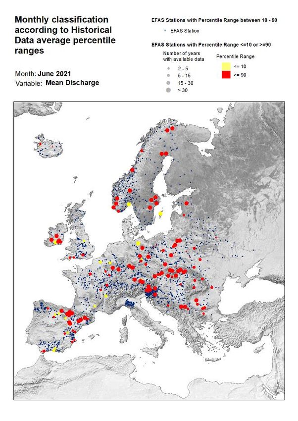
EUROPEAN FLOOD AWARENESS SYSTEM: Bimonthly Bulletin – Issue 2021(4)

the Bay of Biscay to central Europe and triggered again         At the beginning of July, a low-pressure system was
heavy precipitation till the end of the month.                  located north of the Azores. Another low-pressure
                                                                system was situated over the southern Baltic Sea and a
In June 2021, the highest precipitation totals were             high-pressure system over the Norwegian Sea. The
observed in western and central Europe and north of             high-pressure system moved to Northern Scandinavia,
the Black Sea (Figure 16). No or almost no precipitation        while the low-pressure system vanished at the surface,
fell in the African and Middle East parts of the EFAS           but remained in the upper levels and moved eastward.
domain. Monthly precipitation totals above the long-            Due to the unstable atmospheric stratification, many
term mean occurred from the Iberian Peninsula to                heavy precipitation events were triggered (this applies
western-central Europe, around the Black Sea and in             also to the other low-pressure systems mentioned
parts of eastern Europe, Scandinavia as well as                 below). The above-mentioned low-pressure system
                                                                moved from the Atlantic Ocean to Great Britain and
northwest Africa (Figure 17). Monthly totals below the
                                                                Ireland. It was associated with an upper-level trough,
long-term mean were reported over northeast Africa
                                                                which swung eastwards and triggered many severe
and the Middle East, eastern Europe, southern
                                                                thunderstorms at its eastern edge. In the meantime,
Scandinavia, Great Britain and Ireland, Iceland as well         the high-pressure system moved from Scandinavia to
as in the central Mediterranean Region towards the              western Russia. While this high-pressure system
western Carpathian Mountains.                                   weakened, several upper-level low-pressure systems
                                                                moved from the Atlantic Ocean to western and central
The monthly mean air temperature ranged from -4.4°C
                                                                Europe. Some days earlier, a low-pressure system
to 38.9°C with the highest values in the southern parts         developed over northern Canada. It moved via the
of the EFAS domain. The lowest temperature values               Atlantic Ocean and the Bay of Biscay to central Europe,
were reported in the northern and mountainous parts             causing severe floods in these regions, and later shifted
(Figure 20). Air temperature anomalies ranged from -            further towards the Balkans, also associated with
8.3°C to 11.9°C (Figure 21). Monthly mean air                   severe weather also there. In the same days, the
temperatures below the long-term mean occurred in               Azores High moved to Great Britain and Ireland and a
northwest Africa along the Atlantic coast, at the Iberian       low-pressure system moved from the Greenland Sea to
Peninsula, Iceland, east of the Ural Mountains, around          the Arctic Ocean. The high-pressure system weakened
the Black Sea, and the eastern shore of the                     but extended eastwards to central and eastern Europe.
Mediterranean Sea, while positive temperature                   While the high-pressure system moved eastward, a
anomalies appeared in the remaining part of the EFAS            low-pressure system moved from the Atlantic Ocean
                                                                via the Bay of Biscay to the North Sea. It weakened and
domain.
                                                                merged with another low-pressure system from the
                                                                Atlantic Ocean over Great Britain and Ireland. It split
July                                                            into two cores, one moved via southern Scandinavia to
July 2021 was characterized by recurring severe                 the northern Baltic Sea by the end of the month. The
weather, causing many as well as extreme floods.                other and smaller core remained at Great Britain and
Around normal mean sea surface pressure appeared                Ireland and moved later across the North Sea to
nearly everywhere across the EFAS domain. Slightly              southern Scandinavia. Furthermore, the Azores High
lower than normal mean sea surface pressure occurred            was around its usual position by the end of July. The
southwest of Great Britain and Ireland, whereas higher          African and south-eastern parts of the EFAS domain
than normal sea surface pressure was observed around            were characterized by high pressure with weak
Scandinavia and eastern Europe. Monthly precipitation           gradients over the whole month.
totals were above the long-term mean in central and
western Europe as well as around the Black Sea and              The highest precipitation totals were observed in the
below normal over the remaining part of the EFAS                Alps and over central Europe (Figure 18). No or almost
domain. The monthly mean air temperature was lower              no precipitation fell around the Mediterranean Sea, as
than the mean in the northeast of the EFAS domain and           well as in the African and Middle Eastern parts of the
western Europe and higher than the mean over the                EFAS domain. Monthly precipitation totals above the
rest of the EFAS domain.                                        long-term mean occurred in western and central
                                                                Europe, around the Black Sea, and in southern

                                                            4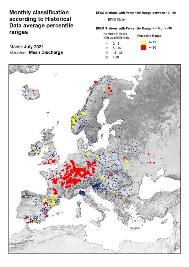
EUROPEAN FLOOD AWARENESS SYSTEM: Bimonthly Bulletin – Issue 2021(4)

Scandinavia (Figure 19). Monthly totals below the long-            degree, other stations above the 90% quantile are
term mean were reported over the Iberian Peninsula,                located in river basins in the Nordic countries (Norway,
Iceland, Northern Scandinavia, the eastern part of                 Sweden, Finland, and Iceland) and the British Isles
eastern Europe, and around the Mediterranean Sea.                  (southern England and Ireland). A handful of stations
                                                                   over the 90% quantile occurred in several basins in
The monthly mean air temperature ranged from -0.9°C                France (Meuse, Seine, Loire, and Rhône) and isolated
to 39.2°C with the highest values in the southern parts            stations in the Maritsa/Evros basin (Bulgaria), Daugava
of the EFAS domain. The lowest temperature values                  basin (Latvia), Dniester basin (Ukraine), and Narva
were reported in the northern and mountainous parts                basin (Estonia).
(Figure 22). Air temperature anomalies ranged from -
10.7°C to 8.7°C (Figure 23). Monthly mean air                      At last, and focusing on those stations registering
temperatures below the long-term mean occurred in                  values below the 10% quantile, although they are quite
western and central Europe as well as in the north-                dispersed throughout Europe, we can find nearly a
eastern part of the EFAS domain, while positive                    third of them in Spain, along the Douro basin in the
temperature anomalies appeared in the remaining                    north, the Jucar basin in the east, and the Guadalquivir
part of the EFAS domain.                                           and Verde basins in the south. In Germany, we have 3
                                                                   stations in the Elbe and Danube basins, 2 stations can
Hydrological situation                                             be found in Belgium in the Scheldt and Meuse basins,
                                                                   and 2 more in France in the Garonne and Rhone basins.
by EFAS Hydrological Data Collection Centre                        Finally, we can also find isolated stations with values
                                                                   under the 10% quantile in the Suir river (Ireland), Hvíta
June                                                               river (Iceland), Ryton river (England), Lagen river
In June, the highest concentration of stations that                (Norway), Uzh river (Ukraine), and the Gothemsan
exceeded their first threshold level is between                    river located on the Swedish island of Gotland.
Switzerland, Italy, Austria, and southern Germany
(mainly on the Rhine), the Po, and the western Danube              July
basins. In a more dispersed way, along the Danube                  In mid-July, several stations located in the Rhine river
basin, there are exceedances in Hungary, Romania,                  basin were affected by a sharp increase in their water
Ukraine, Croatia, Slovenia, and Kosovo. In eastern                 flow, generating devastating floods that mainly
Europe, the Dnieper river basin stands out with 9                  affected Germany and Belgium. Of the 76 EFAS stations
stations overpassing thresholds. A lower concentration             with threshold levels defined in the system and located
of stations can be observed in northern Norway and                 in the Rhine river basin, 43 exceeded almost one of
Sweden, in Iceland, in eastern Spain (around the Jucar             them, in Germany, Switzerland, and Austria and 25 of
basin and in Catalonia), and at last in central Italy (Tiber       them maintained the overflow for more than 10 days.
and Garibliano basins).                                            Other affected areas with exceedances in central
                                                                   Europe were the Danube, Elbe, Oder, and Po river
Regarding stations registering values above the 90%                basins (Germany, Austria, Slovenia, Croatia, Hungry,
quantile, 120 stations exceeded this value in June. The            Slovakia, Poland, Czech Republic, and Serbia). A lower
vast majority of these stations were located in central            concentration of stations can be observed in northern
Europe, where the Danube basin stands out with                     Norway, Iceland, Ireland, eastern Spain (around the
nearly 30% of the total stations exceeding the 90%                 Jucar river basin and Catalonia), central Italy (Tiber and
quantile. These are located through Germany, Austria,              Garbliano basins), and western Ukraine and Belarus.
Czech Republic, Slovakia, Ukraine, Hungary, Romania,
Bulgaria, Serbia, Bosnia and Herzegovina, and Slovenia.            Regarding stations registering values above the 90%
Other basins with stations surpassing the 90% quantile             quantile, 286 stations exceeded this value in July - the
in central Europe are Vistula, Oder, Elbe, Rhine, and              record number of stations surpassing the 90% quantile
Dnieper. Another considerable number of stations also              so far this year. The vast majority of the stations (nearly
surpassing the 90% quantile (just over 16%) can be                 82%) are located in central Europe mainly in France,
found in Spain, mainly in the Ebro basin and the rest in           Germany, Switzerland, Belgium, and Czech Republic.
stations scattered between different basins at the                 These stations are monitoring the river basins of the
north, east, and south of the country. To a lesser                 Rhine (73), Rhône (36), Loire (31), Seine (29), Danube

                                                               5
EUROPEAN FLOOD AWARENESS SYSTEM: Bimonthly Bulletin – Issue 2021(4)

(26), Elbe (14), Meuse, Dordogne, Garonne, Scheldt,                   Figure 5 and Figure 6 shows the EFAS headline score,
Oder, and Orne. Another considerable number of                        the continuous ranked probability skill score (CRPSS)
stations also surpassing the 90% quantile can be found                for lead times 1 and 5 days for June-July across the
in Great Britain (mainly in the Thames basin). To a                   EFAS domain for catchments larger than 2000km2. A
minor extent, values exceeding the 90% quantile can                   CRPSS of 1 indicates perfect skill, 0 indicates that the
be found in stations in Spain: (south, east and north-                performance is equal to that of the reference, and any
western basins). To a lesser degree, other stations over              value 2000km2. The reference score is persistence of
Elde river (Germany), and the Notec river (Poland).                   using previous day’s forecast.

                                                                      These maps indicate that across much of Europe for
Verification                                                          forecasts are more skilful than persistence at both lead
                                                                      times. Regions shown in blue are those where EFAS
                                                                      forecasts are more skilful than persistence, with darker
                                                                      shading indicating better performance.

                                                                      The skill of the forecast was quite good over the period,
                                                                      and similar to the same period last year (Figure 7). An
                                                                      inter-annual variability of the scores is to be expected.
                                                                      The long-term trend is neutral over the first two years
                                                                      since the domain was extended, but there is an
                                                                      indication of increase in skill with EFAS 4.0, especially
                                                                      for the areas with generally lower skill.

Figure 5: EFAS CRPSS at lead-time 1 day for June-July 2021, for
catchments >2000km2. The reference score is persistence of
using previous day’s forecast.

                                                                  6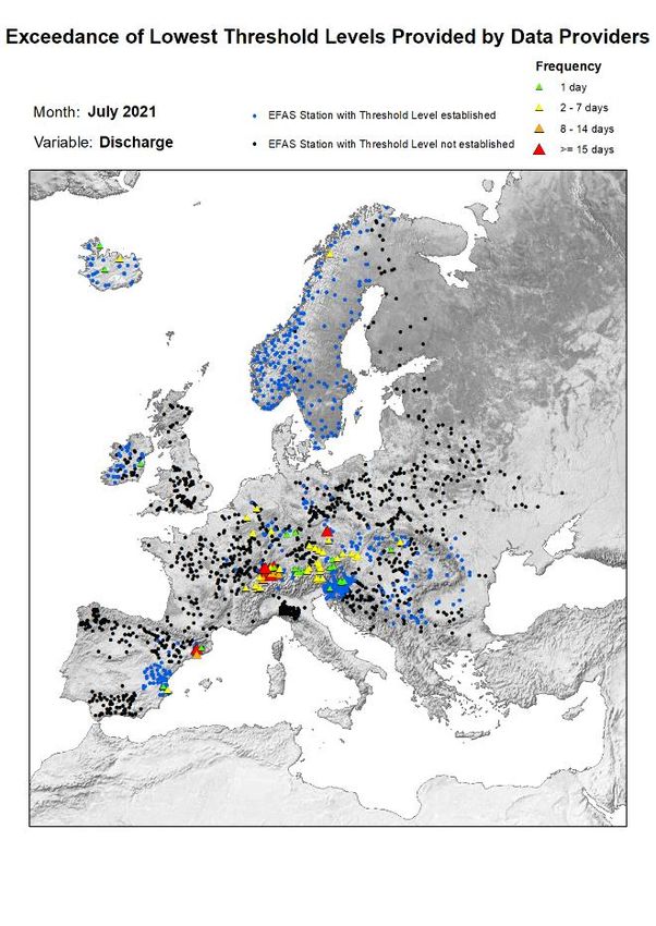
EUROPEAN FLOOD AWARENESS SYSTEM: Bimonthly Bulletin – Issue 2021(4)

                                                                      significant flood events included those seen in
                                                                      southern Germany, Austria, and Switzerland; Crimea
                                                                      and Russia’s Black Sea region; southeast England;
                                                                      northern Italy, and eastern Europe.

                                                                      Southern Germany, Austria, and Switzerland: Just
                                                                      days after the flooding in the western states of North
                                                                      Rhine-Westphalia and Rhineland-Palatinate in
                                                                      Germany, flash floods swept through the southern
                                                                      state of Bavaria on 17 July. The district of
                                                                      Berchtesgadener Land declared a disaster.

                                                                      Rivers broke their banks in parts of neighbouring
Figure 7. Monthly means of CRPSS the for lead-time 5 days for         northern Austria on the same day, causing widespread
all the major river points in Europe with ECMWF ENS as forcing.       damage in several towns in the state of Salzburg.
Reference forecast was climatology. The skill is largest during
the winter months, when there is less variation in the flow in
large parts of Europe. The blue line indicates the release of
EFAS 4.0.

ARTICLES
Widespread European Flooding, July 2021
by Richard Davies, floodlist

A series of summer storms and severe weather in
Europe in July resulted in significant rainfall and
flooding throughout the month. FloodList recorded
over 40 flood events - both major and minor - in more
than 135 locations across the continent.
                                                                      Figure 9: Floods in Hallein, Salzburg, Austria, 18 July 2021.
                                                                      Photo: Land Salzburg

                                                                      Parts of Switzerland saw dramatic flooding struck on 24
                                                                      July when 26 mm of rain fell in just 10 minutes in
                                                                      Wolhusen in the district of Entlebuch, Lucerne Canton.
                                                                      Raging torrents of water swept vehicles along the
                                                                      streets of Wolhusen and dumped them into the Kleine
                                                                      Emme river below.

                                                                      Black Sea: Areas along the Black Sea saw significant
                                                                      flooding from 03 to 06 July, including districts in the
                                                                      Crimea for the second time in 2 weeks and Russia’s
Figure 8: Aerial photo of the flood in Oberpinzgau between
                                                                      Krasnodar Region where 8 fatalities were reported.
Mittersill and Bramberg, Austria, 18 July 2021. Photo: Land
Salzburg / Franz Wiese                                                Officials said areas saw more than 2 months’ worth of
                                                                      rain in a few hours. The city of Sochi saw yet more
As well as the catastrophic floods in Belgium, western                flooding on 23 July where 4 people lost their lives.
Germany, Luxembourg, and the Netherlands, other

                                                                  7
EUROPEAN FLOOD AWARENESS SYSTEM: Bimonthly Bulletin – Issue 2021(4)

Southeast England: In the UK, the capital London and               Eastern Europe: In eastern Europe, stormy weather
southeast England saw flash flooding from 10 to 12                 resulted in minor flooding in Poland throughout the
July. The London Fire Brigade received more than 1,000             month of July. Flooding was also reported in Czechia,
calls related to flooding.                                         Slovakia, Croatia, Serbia, and Romania where one 1
                                                                   person died, and dozens were evacuated or rescued by
More flooding struck in the city on 25 July. Vehicles
                                                                   emergency services from 15 to 20 July. The counties of
were stranded on flooded roads, including on the M11
                                                                   Iași, Argeș, Neamț, and Alba were the worst affected
motorway, and several train stations were closed. UK’s
                                                                   areas.
Met Office said St James Park in central London
recorded 41.6 mm of rain on 25 July.                               For a comprehensive list of European flood events
                                                                   during July 2021 supplied by FloodList, we refer to the
                                                                   related news item on EFAS-IS

                                                                   FAQs on EFAS and the information EFAS provided
                                                                   during the flood events affecting the Rhine and
                                                                   Meuse river basins

                                                                   In view of the numerous questions received in relation
                                                                   to EFAS and the recent flood events affecting the Rhine
                                                                   and Meuse river basins, a Frequently Asked Questions
                                                                   document has been prepared outlining the main aim of
Figure 10: Floods in London 25 July 2021. Photo: London Fire       EFAS and what information was provided by EFAS
Brigade                                                            during these flood events.

Northern Italy: Areas around Lake Como suffered                    What information did EFAS provide in relation to the
landslides and flash floods after heavy rain flowed                recent flood events affecting the Rhine and Meuse
down slopes around the lake, causing significant                   river basins?
material damages in the communes of Cernobbio,                     On 9 and 10 July, flood forecasts by the European Flood
Brienno, Laglio, and Argegno in Como Province,                     Awareness System (EFAS) of the Copernicus
Lombardy Region, on 27 July.                                       Emergency Management Service indicated a high
                                                                   probability of flooding for the Rhine River basin,
                                                                   affecting Switzerland and Germany.

                                                                   The following day, subsequent forecasts also indicated
                                                                   a high risk of flooding for the Meuse River basin,
                                                                   affecting Belgium. The magnitude of the floods
                                                                   forecasted for the Rhine River basin increased
                                                                   significantly in this period.

                                                                   The first EFAS notifications for the Rhine River basin
                                                                   were sent to the relevant national authorities starting
                                                                   on 10 July. The first EFAS notifications for the Meuse
                                                                   River basin were sent to the relevant national
                                                                   authorities starting on 12 July. With the continuously
                                                                   updated forecasts, more than 25 notifications were
                                                                   sent for specific regions of the Rhine and Meuse River
Figure 11: Flood damage in Como Province, Lombardy, Italy 27       basins in the following days until 14 July.
July 2021. Photo: Government of Lombardy

                                                               8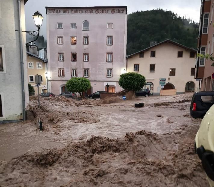
EUROPEAN FLOOD AWARENESS SYSTEM: Bimonthly Bulletin – Issue 2021(4)

When, and on which basis does EFAS issue flood                    information, and to analyse the situation together with
notifications?                                                    the available national or local early warning
                                                                  information, to decide on the next actions.
EFAS produces twice-daily updated hydrological
predictions for riverine and flash floods across Europe.          Who receives EFAS flood notifications?
These are analysed by trained hydrologists and, based
on standardised criteria, EFAS flood forecast                     EFAS flood notifications are sent out to all the “EFAS
information, called ‘EFAS flood notifications’, are               partners” (see here for a list of EFAS
issued.                                                           partners: https://www.efas.eu/en/partners-list-0 ) in
                                                                  the potentially affected river basin and the European
EFAS flood notifications are issued based on the type             Response and Coordination Centre (ERCC), the heart of
of flooding (e.g. riverine or flash flood), its probability       the EU Civil Protection Mechanism, in order to create
of exceeding specific notification criteria (e.g.                 early awareness on the high risk of flooding in the
probability for the predicted river discharge to exceed           coming days. An ‘EFAS partner’ is any national, regional
a 5-year return period) and other criteria such as the            or local authority with a legal obligation to provide
size of the river.                                                flood forecasting services or that has an institutional
                                                                  mandate in flood risk management within its
What type of information is contained in EFAS flood               territory. In the case of trans-national river basins,
notifications?                                                    EFAS notifications are also shared with national
                                                                  authorities that might not be immediately affected by
EFAS flood notifications contain an indication of the             the forecasted flood (e.g. EFAS notifications for the
potentially affected larger region or river/tributary             German section of the Rhine are always also shared
section and a very short and basic information on the             with the relevant Dutch and Belgian authorities). EFAS
predicted probabilities to exceed a certain flood return          notifications related to flash floods are only sent to the
period. Furthermore, there is an advisory message to              relevant national or regional authority.
follow a link to access the more detailed, regularly
updated flood forecast information displayed in the               Are EFAS flood notifications available to the public?
EFAS web portal. An example of a typical flood
notification is shown below:                                      EFAS notifications are not aimed at warning the public
                                                                  as the notifications contain expert information that
                                                                  should be combined with the relevant available
                                                                  national and local information to provide the best
                                                                  possible basis for decision making.

                                                                  To respect the national competence for warnings and
                                                                  the single-one-voice warning principle, EFAS Flood
                                                                  notifications and other related forecast information
                                                                  cannot be shared publicly unless the relevant national
                                                                  authority decides to share the information.

                                                                  Archived EFAS forecast data including an overview of
                                                                  EFAS         flood        notifications        (example:
                                                                  https://www.efas.eu/en/notifications?field_month_v
                                                                  alue=05&field_year_value=2021) and a list of all flood
                                                                  notifications indicating the river section or region, the
What are the usual next steps after EFAS has sent a               lead time, the forecast date and the main affected
flood notification?                                               country are publicly available after 30 days.
                                                                  (example: https://www.efas.eu/sites/default/files/efa
Once an EFAS notification has been received, the                  sBulletins/2021/EFAS_Bimonthly_Bulletin_Apr_May2
relevant national authority is advised to connect to the          021_0.pdf)
EFAS map viewer for a more detailed forecast

                                                              9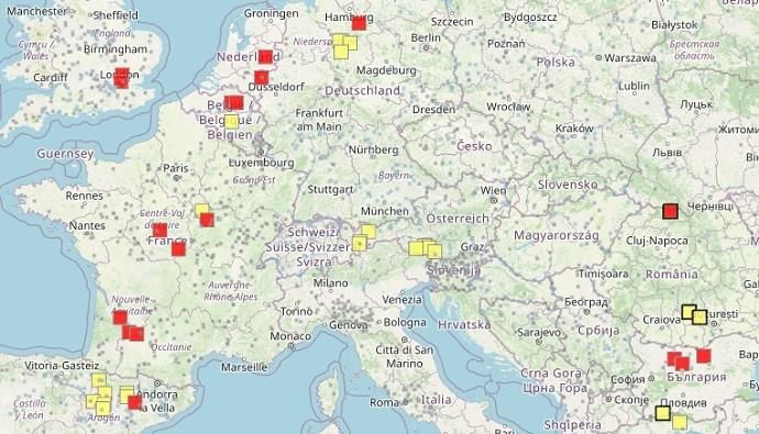
EUROPEAN FLOOD AWARENESS SYSTEM: Bimonthly Bulletin – Issue 2021(4)

Are EFAS Flood Notifications without any obligation?             draw the necessary conclusions from all available
                                                                 information.
Yes. EFAS notifications aim at providing
complementary forecast information. The relevant                 EFAS is a European scale forecasting system that aims
national authority may or may not use the provided               to provide additional forecast information at the larger
forecast information, and is likely to also take into            scale (river basin wide, European scale) including flash
account other information in deciding on any measures            floods and with longer forecast horizons then most
to be taken.                                                     national systems to raise early awareness about the
                                                                 risk of flooding. The reliability of EFAS forecasts are
Does EFAS monitor what is being done after the                   assessed using a number of different technical skill
notification has been issued?                                    scores that are published and available on the website
                                                                 and the map viewer.
EFAS monitors the flood situation but does not monitor
actions taken by national authorities based on EFAS              General info about EFAS, the Copernicus Emergency
flood forecast information or national warning system            Management Service and early warning
information, as such actions fall outside EU                     What is EFAS?
competence.
                                                                 The European Flood Awareness Systems (EFAS;
Does EFAS request acknowledgement of receipt from                www.efas.eu) of the Copernicus Emergency
the relevant authorities once a notification has been            Management                 Service               (CEMS;
received?                                                        https://emergency.copernicus.eu/) is the first
                                                                 operational pan-European flood forecasting and
Partners who receive an EFAS Flood notification are              monitoring system. EFAS provides a wide range of
not requested to send acknowledgement of receipt. In             complementary early flood forecasting information
a flood situation, forecasting and emergency response            based on models, satellite and in-situ data, to support
authorities are extremely busy with processing and               national and regional authorities with flood risk
integrating all relevant information coming from a               management duties in arranging preparatory
variety of sources and usually only reply to                     measures before an event strikes. In addition, EFAS
notifications if further questions arise. Regular                provides a unique overview across Europe and
feedback on EFAS flood notifications is requested in             neighbouring countries on currently observed and
the aftermath of an event to continuously adapt and              forecasted flood events.
improve the system.
                                                                 Why and when was EFAS founded?
Does EFAS forecast floods only for large rivers?
                                                                 In 1999 the Joint Research Centre (JRC) of the
EFAS aims at predicting floods for large rivers and their        European Commission started a research study for a
tributaries but provides as well flash flood predictions         European scale flood forecasting system (EFFS) in
for smaller scale rivers. In the case of the Meuse and           collaboration with national authorities and experts
Rhine river flood events both, predictions for the large         from different Member States.
scale river sections of the Rhine and Meuse as well as
the flash flood predictions for many of the small scale          The disastrous floods in Elbe and Danube rivers in 2002
tributaries of these river basins indicated a high               confronted the European Commission with non-
probability of flooding or flash flooding, respectively.         coherent flood warning information from different
                                                                 sources and of variable quality, complicating planning
Are EFAS forecasts precise and reliable?                         and organisation of aid. The EFFS, developed at the
                                                                 JRC, provided successfully ad-hoc simulations of the
EFAS does not make any claims as to the completeness             ongoing floods and a forecast on how the flood waves
of the information provided. On the contrary, EFAS               could be expected to travel down the Danube river.
forecasts are complementary to national warning and
information systems, and it is the competence of                 In response to this event and following a
national or regional / local competent authorities to            Communication of the Commission on the Elbe and

                                                            10
EUROPEAN FLOOD AWARENESS SYSTEM: Bimonthly Bulletin – Issue 2021(4)
Danube floods, the Joint Research Centre of the Who is responsible for preventing, preparing and
European Commission was assigned with the task to responding to natural and man-made disasters in EU
further develop EFFS into a fully operational, Member States?
European-wide flood forecasting model. The first
developments towards such a European Flood The primary responsibility for preventing, preparing for
Awareness System (EFAS) were initiated in 2003, (including early warning and public warning), and
together with experts from Austria, Czech Republic, responding, to natural and man-made disasters lies
Germany, Hungary, and Slovakia and using forecasts with the Member States.
from the German weather service.
On what basis is the European Commission
In 2004 a collaboration agreement with ECMWF was supporting Member States in the field of early
signed, allowing the JRC to also incorporate ECMWF warning?
ensemble prediction data and its higher resolution Art. 8 (c) of the of the Regulation 2021/836 amending
deterministic forecast into EFAS in real-time. Decision No 1313/2013/EU on a Union Civil Protection
Mechanism (UCPM) has attributed a mandate to the
From 2005 to 2010 EFAS was tested in real-time mode, European Commission in the field of EWS to
together with the newly established EFAS partner complement and support the work of the Member
network, consisting of national and regional flood States developing, e.g. transnational detection and
forecasting authorities, and later also with the early warning systems, such as the European Flood
European Civil Protection. Awareness System, mainly for transboundary floods.
In 2011 EFAS became part of the Copernicus
Emergency Management Service initial operations and Global Hydrological Workshop 2021
in support to European Civil Protection. The
by Karen O’Regan, Ilias Pechlivanidis & Maria-Helena Ramos
operational components have been outsourced to
Member State organisations. Close to 600 people registered for the Joint Virtual
Workshop on "Connecting global to local hydrological
EFAS is running fully operational since autumn 2012.
modelling and forecasting: scientific advances and
What other services relevant for flood risk challenges" which ran from 29 June 2021 to 01 July
management are available under CEMS 2021. Attendance for the event was impressive – with
over one thousand unique attendees viewing the
The rapid mapping component of the Copernicus livestreamed presentations on ECMWF’s virtual event
Emergency Management Service (CEMS) provides platform and over 70 attending each of the interactive
mapping products based on satellite imagery and is poster sessions in gather.Town.
usually activated for a certain area by an authorised
user (typically regional/national authority responsible The sessions were headlined by six excellent keynote
for civil protection). For this event, the rapid mapping talks from our guest speakers on various subjects of
component of CEMS is providing critical flood maps interest to the wider hydrological community. We
and damage assessment since 13 July for the floods in received submissions of nearly 100 abstracts on
Germany, Netherlands, Belgium and Switzerland. An hydrology and related topics presented in poster
EFAS based pre-tasking of the rapid mapping format which described work ranging from global
component was launched on 14th July for the Upper hydrology, earth observation and machine learning, to
and Lower part of Rhine Basin and on 15th July for the catchment-scale modelling and forecasting, with links
Meuse River basin in order provide timely flood to local decision making. Recordings of keynote talks
observations to the civil protection authorities. All
and presentation slides can be viewed on the
mapping products can be found at this
dedicated workshop webpage.
link: https://emergency.copernicus.eu/mapping/ems/
copernicus-emergency-management-service-
forecasts-notifies-and-monitors-devastating-floods
11EUROPEAN FLOOD AWARENESS SYSTEM: Bimonthly Bulletin – Issue 2021(4)
Figure 12: Participants of the Joint Virtual Workshop on Connecting global to local hydrological modelling and forecasting:
scientific advances and challenges.
Irina Sandu (ECMWF) introduced the European relevance and value of emergency management
Commission’s Destination Earth (DestinE) programme. services. One of the main key messages delivered was
The programme aims to advance further the Earth that global forecasts can provide a consistent source of
system modelling across all scales. This is a key effort information to local authorities, with longer lead times
that will not only develop a high precision model of the and state-of-the art ensemble forecasts. However, on
Earth but also provides information to support their own, they are not building national capacity.
sustainable development and environmental policy More work is needed to facilitate feedback from
making. It is expected to include hydrological extremes national hydrometeorological and engagement on
(floods and droughts) for a better understanding of systems’ developments.
their drivers and impacts on building resilience under
Micha Werner (IHE Delft) introduced a human-centred
future climate conditions. Coordinated model
approach that more explicitly considers local needs,
development efforts between the atmosphere/land
knowledge, and policy contexts, to evolve large-scale
and hydrology communities are anticipated.
climate services and ensure their uptake for addressing
Wendy Parker (Virginia Tech) analysed the perspective users’ challenges. With examples on water allocation,
of uncertainty communication within the hydrological flash flood forecasting and rain-fed agriculture from all
modelling sphere, where large sets of ensembles are over the world, it was shown how different
currently considered as a state-of-the-art. The keynote perspectives need to be considered when evaluating
talk emphasised the need to change the way we view how good or how useful a forecast is. Listening to what
our models: from a mirror view, where models are local people have to say is as important as listening to
perceived as faithful representations of the world and our data and global models.
improving a model means adding detail and/or
Louise Slater (University of Oxford) provided an
increasing fidelity, to a fit-for-purpose modelling view,
overview of the recent developments with statistical
where models are seen as representational tools that
models, including machine learning, and their
should be adequate/fit for a wide range of purposes of
applications to predict different hydroclimatic
interest.
variables. She discussed the emergence of hybrid
Liz Stephens (University of Reading) focused on the use (dynamical/statistical) hydrological forecasting
of global forecasting for anticipatory humanitarian alongside traditional approaches and highlighted some
action, while highlighting the need to strengthen potential strengths of hybrid forecasting; operational
partnerships with local communities to improve the convenience (post-processing), learning from
12EUROPEAN FLOOD AWARENESS SYSTEM: Bimonthly Bulletin – Issue 2021(4)
nonstationary predictors, reducing biases, combining networking breaks were hosted on ECMWF’s
sources of predictability. Remaining key challenges gather.Town platform. This method of hosting the
pointed out to data requirements, physical plausibility workshop received much positive feedback from
of model outputs and the assimilation of human attendees, who enjoyed its game-like feel and ‘natural’
influences in water systems. networking opportunities. One attendee stated: “The
workshop was really engaging. The ‘virtual ECMWF’ on
Guy Schumann (University of Bristol) provided an
Gather Town was a big hit. It allowed our hydrological
overview of the advances in Earth Observation (EO)
community to interact at a more intensive level. The
technologies and conveyed the opportunities EO
poster sessions felt very natural with people ‘walking’
advancements could offer to flood modelling and
past and many small group discussions were ignited.
forecasting. The need to democratize availability,
There was even an Early Career hangout room that
access and affordability of commercial EO data was
again provided fantastic networking opportunities.”
highlighted. A call for action to the effective integration
of the latest advances and capabilities of EO and Earth
system modelling was issued towards, routinely
evaluating flood forecasts, diagnosing forecast
problems, and developing novel initialization,
calibration, and post-processing procedures to deliver
more skilful and reliable forecasts at longer lead times
globally.
High quality research was also presented during the
poster presentations, which covered six broad themes,
from challenges and advances in modelling hydrologic
variables at large scales (coupled water prediction
systems), to catchment-scale hydrometeorological
forecasting (nowcasting, short, medium and long Figure 13: An interactive ‘Activity Booth’ demonstration of
ranges), monitoring, modelling and forecasting flood how to use datasets in the online processing suite, the CDS
(Climate Data Store) Toolbox during the gather.Town session
risk, and inundation mapping. Impact assessments and
of the workshop.
connections of large-scale water-cycle information to
local needs, knowledge and decision making were also The workshop was organised by a collaborative effort
central to the workshop. from the European Centre for Medium-range Weather
Forecasts (ECMWF), the Copernicus Emergency
Several posters addressed challenges and new
Management Service (CEMS), the Copernicus Climate
techniques on post-processing model outputs and
Change Service (C3S), the Hydrological Ensemble
evaluating forecast skill. The use of Earth Observations
Prediction EXperiment (HEPEX) and the Global Flood
and data assimilation for hydrological forecasts and
Partnership (GFP). Six chairs hosted the ensemble of
past reanalyses was explored as opportunities to
discussions, Hannah Cloke (University of Reading, UK),
better link global to local scales. The community has
Christel Prudhomme (ECMWF, UK), Maria-Helena
been investigating new methodologies and practices
Ramos (INRAE, France), Peter Salamon (European
that clearly are a step beyond the current state-of-the-
Commission, Joint Research Centre, Italy), and Ilias
art. All posters presented during the workshop are
Pechlivanidis (SMHI, Sweden), with the support of
available on the posters page of the workshop website.
Karen O’Regan (ECMWF). The workshop was an
We strongly invite you to view the posters or directly
excellent opportunity to showcase the hard work and
contact the authors and initiate a fruitful scientific
inspiring science being produced within the global
exchange of knowledge.
hydrological community. We extend our thanks to
All interactive aspects including poster sessions, the those who contributed to and attended this impressive
Sci-Art event, CDS/CEMS/C3S information booths, and virtual event!
13EUROPEAN FLOOD AWARENESS SYSTEM: Bimonthly Bulletin – Issue 2021(4)
ECMWF’s role in the Copernicus Emergency Since then, both systems have provided the European
Management Service renewed Union's Emergency Response Coordination Centre
(ERCC), national hydrological and meteorological
by Georg Lentze
services (NHMS) and authorised users with a reliable
and robust 24/7 service, including daily overviews on
ECMWF is to continue as the computational centre for
ongoing and predicted major floods in Europe and the
the hydrological forecasting activities of the EU-funded
world.
Copernicus Emergency Management Service (CEMS)
for a further six years until 2027. EFAS now has over 900 users from 141 institutions,
while GloFAS has over 6,000 registered users
The computational centre helps to deliver the
worldwide.
European and Global Flood Awareness Systems, EFAS
and GloFAS.
Figure 15: This EFAS map shows the risks of flooding on 12 June
2021. The red (yellow) squares show river points where
flooding within the next 10 days is expected to exceed the 5-
year (2-year) return period.
Figure 14: The disastrous flood which hit several European
countries in July 2021 illustrates well the importance of EFAS ECMWF’s role
as a critical European tool to forecast flooding events. As the
intensity and frequency of severe weather events increases As the CEMS Hydrological Forecast Centre –
around the world, it is paramount that forecasting skill should
continue to improve. (Photo of Erfstadt-Blessem, Germany –
Computation (COMP), ECMWF is responsible for the
credit: Rhein-Erft-Kreis) operation of the CEMS state-of-the-art hydrological
probabilistic forecasting systems, which includes
The new framework contract is managed by the Joint ECMWF ensemble weather forecasts, as a 24/7 service.
Research Centre (JRC) of the European Commission –
the entrusted entity responsible for CEMS – and has It is also in charge of the service evolution, migrating
been awarded to ECMWF for the third time. from research to operations new components
developed by either ECMWF or other collaborators,
Flood awareness systems such as the JRC. This includes:
The European and Global Flood Awareness Systems • implementing scientific advances to improve
EFAS and GloFAS are at the core of the CEMS Early hydrological forecast skill (e.g. hydrological
Warning System (CEMS-EWS) Flood component. modelling, product definition, error
diagnostics, and performance improvement);
EFAS was the first of the CEMS-EWS services, run
• continuous system upgrades, such as
operationally by ECMWF since 2011 following its integrating new observational data and
development by the JRC. In parallel, GloFAS, co developing user-defined forecast products;
developed by ECMWF and the JRC in collaboration with • delivering service improvements, ranging
the University of Reading, was run by ECMWF as a from website design and functionalities to
prototype service from 2011 and became operational optimised flood notification criteria;
in 2018.
14EUROPEAN FLOOD AWARENESS SYSTEM: Bimonthly Bulletin – Issue 2021(4)
• any development to ensure the timely delivery • Hydrological forecast improvement. This
of products (e.g. system component and includes new calibration for EFAS and a new
processing chain optimisation, continuous hydrological model for GloFAS delivered in
integration, software upgrade and 2020. An increase in the spatial resolution is
maintenance). planned for both. This may also include the
implementation of new components, such as
improved river routing or development of a
ECMWF’s responsibilities include developing, data assimilation module in the LISFLOOD
maintaining and hosting EFAS and GloFAS Information model, now used for both EFAS and GloFAS.
Systems and associated web services, in particular • Product evolution. This includes improved
delivering tailored tools for the CEMS Hydrological flood impact forecast assessments delivered
Forecast Centre - Analytics and Dissemination. in 2020–2021, but also optimisation of flood
notification criteria, or improvement in the
ECMWF also integrates in the web platform relevant flash flood forecasting method.
new products from other CEMS services as required, • Service evolution. This includes access to all
such as Global Flood Monitoring products, and hydrological simulations through the C3S
provides data services, e.g. to other Copernicus Climate Data Store (started in 2019), improved
Services. websites and services, enhanced data sharing
functionalities, and improved and extended
ECMWF engages strongly with the CEMS-EWS for collaboration with and feedback from users.
Floods user community. This ranges from being
responsible for EFAS and GloFAS user management More information
and service access to providing user support for all
EFAS and GloFAS products and services. EFAS and GloFAS have dedicated web interfaces
accessible through registration: www.efas.eu and
Finally, ECMWF contributes to training and outreach http://www.globalfloods.eu respectively.
activities with other CEMS hydrological forecast
centres, by hosting meetings, delivering hydrological In addition, a CEMS-Floods wiki provides more detailed
bulletins, contributing to the Copernicus Climate information on the different service elements.
Change Service (C3S) State of the Climate reports, and
promoting EFAS and GloFAS at relevant conferences
and workshops.
In addition to the computational centre, three other
operational centres deliver the CEMS-EWS for Floods,
with support from the JRC: the CEMS-Flood Data
Collection Centres METEO (KISTERS AG and DWD) and
HYDRO (Soologic), and the CEMS Hydrological Forecast
Centre - Analytics and Dissemination DISS (SMHI,
SHMU and Rijkswaterstaat). ECMWF has strong
interactions with all of them.
EFAS and GloFAS developments
As operational services, EFAS and GloFAS are always
evolving to provide state-of-the-art flood forecasts and
web and data services to registered users. A lot has
happened in the last few years, with developments
expected to continue during the next phase of the
service:
15EUROPEAN FLOOD AWARENESS SYSTEM: Bimonthly Bulletin – Issue 2021(4)
Acknowledgements
The following partner institutes and contributors are gratefully acknowledged for their contribution:
• DG GROW - Copernicus and DG ECHO for funding the EFAS Project
• All data providers including meteorological data providers, hydrological services & weather forecasting
centres
• The EFAS Operational Centres
• Richard Davies, Floodlist.com
Cover image: Photo of Erfstadt-Blessem, Germany – credit: Rhein-Erft-Kreis
16EUROPEAN FLOOD AWARENESS SYSTEM: Bimonthly Bulletin – Issue 2021(4)
Appendix – figures
Figure 16: Accumulated precipitation [mm] for June 2021. Figure 18: Accumulated precipitation [mm] for July 2021.
Figure 17: Precipitation anomaly [%] for June 2021, relative to Figure 19: Precipitation anomaly [%] for July 2021, relative to
a long-term average (1990-2013). Blue (red) denotes wetter a long-term average (1990-2013). Blue (red) denotes wetter
(drier) conditions than normal. (drier) conditions than normal.
17EUROPEAN FLOOD AWARENESS SYSTEM: Bimonthly Bulletin – Issue 2021(4)
Figure 20: Mean temperature [°C] for June 2021. Figure 22: Mean temperature [°C] for July 2021.
Figure 21: Temperature anomaly [°C] for June 2021, relative Figure 23: Temperature anomaly [°C] for July 2021, relative to
to a long-term average (1990-2013). Blue (red) denotes colder a long-term average (1990-2013). Blue (red) denotes colder
(warmer) temperatures than normal (warmer) temperatures than normal.
18EUROPEAN FLOOD AWARENESS SYSTEM: Bimonthly Bulletin – Issue 2021(4)
Figure 24: Monthly discharge anomalies June 2021. Figure 26: Monthly discharge anomalies July 2021.
Figure 25: Lowest alert level exceedance for June 2021. Figure 27: Lowest alert level exceedance for July 2021.
19EUROPEAN FLOOD AWARENESS SYSTEM: Bimonthly Bulletin – Issue 2021(4)
Figure 28: Lowest threshold exceedance for June 2021. Figure 29: Lowest threshold exceedance for July 2021.
20EUROPEAN FLOOD AWARENESS SYSTEM: Bimonthly Bulletin – Issue 2021(4)
Figure 30: EFAS flood notifications sent for June 2021. Figure 32: EFAS flood notifications sent for July 2021.
Figure 31: Flash flood notifications sent for June 2021. Figure 33: Flash flood notifications sent for July 2021.
21Appendix - tables
Table 1: EFAS flood notifications sent in June – July 2021
Lead
Type Forecast date Issue date River Country
time
Informal 31/05/2021 12UTC 01/06/2021 36 BZIPI Georgia
Informal 31/05/2021 12UTC 01/06/2021 30 KURDZHIPS Russia
Formal 01/06/2021 12UTC 02/06/2021 84 Umeälven Sweden
Informal 01/06/2021 12UTC 02/06/2021 24 Coastal Catchment Black Sea Ukraine
Formal 04/06/2021 00UTC 04/06/2021 48 Coastal zone Iceland
Informal 04/06/2021 12UTC 05/06/2021 0 Belaja Russia
Informal 06/06/2021 00UTC 06/06/2021 0 Glomma Norway
Informal 06/06/2021 00UTC 06/06/2021 0 Voronja Russia
Formal 09/06/2021 12UTC 10/06/2021 0 Malaja Laba Russia
Formal 10/06/2021 00UTC 10/06/2021 48 Luleälven Sweden
Formal 10/06/2021 00UTC 10/06/2021 48 Tjeggelvas Sweden
Formal 15/06/2021 00UTC 15/06/2021 30 Yantra Bulgaria
Formal 15/06/2021 00UTC 16/06/2021 48 Coastal Catchment Black Sea Russia
Informal 17/06/2021 00UTC 17/06/2021 30 Ialomita (Yalomita) Romania
Informal 17/06/2021 00UTC 17/06/2021 54 Moell Austria
Informal 20/06/2021 00UTC 20/06/2021 30 Skellefteälven Sweden
Informal 23/06/2021 00UTC 23/06/2021 0 Khrami Georgia
Informal 23/06/2021 00UTC 23/06/2021 0 Kaczawa Poland
Informal 26/06/2021 00UTC 26/06/2021 0 Voronja Russia
Informal 01/07/2021 12UTC 02/07/2021 30 Lower Havel waterway Germany
Informal 02/07/2021 00UTC 02/07/2021 6 Havel Germany
Informal 03/07/2021 12UTC 04/07/2021 30 Coastal Catchment Black Sea Georgia
Informal 03/07/2021 12UTC 04/07/2021 36 Rioni Georgia
Informal 04/07/2021 00UTC 04/07/2021 18 Coastal Catchment Black Sea Ukraine
Formal 06/07/2021 00UTC 06/07/2021 60 Reuss Switzerland
Informal 06/07/2021 00UTC 06/07/2021 54 Rhine Switzerland
Formal 06/07/2021 12UTC 07/07/2021 60 Aare Switzerland
Informal 08/07/2021 00UTC 08/07/2021 24 Ohre Czechia
Informal 08/07/2021 00UTC 08/07/2021 24 Ohre Czechia
Informal 08/07/2021 00UTC 08/07/2021 24 Naab Germany
Informal 08/07/2021 00UTC 08/07/2021 36 Danube Germany
Informal 10/07/2021 00UTC 10/07/2021 18 Havel Germany
Informal 10/07/2021 00UTC 10/07/2021 84 Rhine Germany
Formal 11/07/2021 00UTC 11/07/2021 66 Rhine Germany
Informal 12/07/2021 00UTC 12/07/2021 36 Ourthe Belgium
Formal 12/07/2021 00UTC 12/07/2021 36 Demer Belgium
Formal 12/07/2021 00UTC 12/07/2021 30 Rhine Switzerland
Informal 12/07/2021 00UTC 12/07/2021 36 Rur Netherlands
Formal 12/07/2021 12UTC 13/07/2021 30 Ourthe Belgium
Formal 12/07/2021 12UTC 13/07/2021 60 Rhine Netherlands
Formal 12/07/2021 12UTC 13/07/2021 24 Rur Netherlands
Informal 13/07/2021 00UTC 13/07/2021 6 Nahe Germany
Formal 13/07/2021 00UTC 13/07/2021 18 Doubs France
Informal 13/07/2021 00UTC 13/07/2021 30 Meuse Netherlands
Formal 13/07/2021 12UTC 14/07/2021 30 Moselle Germany
22Informal 14/07/2021 00UTC 14/07/2021 18 Sauer Luxembourg
Informal 19/07/2021 00UTC 19/07/2021 6 Danube Slovakia
Formal 21/07/2021 00UTC 21/07/2021 6 Danube Hungary
Informal 21/07/2021 00UTC 21/07/2021 12 Prut Romania
Formal 21/07/2021 00UTC 21/07/2021 42 Prut Moldova
Informal 21/07/2021 00UTC 21/07/2021 6 Danube Hungary
Formal 21/07/2021 00UTC 21/07/2021 18 Siret Romania
Informal 21/07/2021 00UTC 21/07/2021 0 Olt Romania
Formal 21/07/2021 00UTC 21/07/2021 60 Danube Croatia
Formal 21/07/2021 00UTC 21/07/2021 54 Danube Serbia
Informal 22/07/2021 12UTC 23/07/2021 60 Donau Germany
Informal 27/07/2021 00UTC 27/07/2021 36 Spey United Kingdom
* Lead time [days] to the first forecasted exceedance of the 5-year simulated discharge threshold.
Table 2: EFAS flash flood notifications sent in June – July 2021
Lead
Type Forecast date Issue date Region Country
time
Flash Flood 31/05/2021 12UTC 01/06/2021 30 Neamt Romania
Flash Flood 31/05/2021 12UTC 01/06/2021 30 Suceava Romania
Flash Flood 03/06/2021 12UTC 04/06/2021 42 Puy-de-Dome France
Flash Flood 04/06/2021 00UTC 04/06/2021 48 Teruel Spain
Flash Flood 04/06/2021 00UTC 04/06/2021 42 Guadalajara Spain
Flash Flood 06/06/2021 00UTC 06/06/2021 42 Plovdiv Bulgaria
Flash Flood 06/06/2021 12UTC 07/06/2021 30 Pazardzhik Bulgaria
Flash Flood 06/06/2021 12UTC 07/06/2021 36 Kyustendil Bulgaria
Flash Flood 07/06/2021 00UTC 07/06/2021 18 Blagoevgrad Bulgaria
Provincia Autonoma di
Flash Flood 08/06/2021 12UTC 09/06/2021 30 Italy
Bolzano/Bozen
Flash Flood 12/06/2021 00UTC 12/06/2021 36 Neamt Romania
Flash Flood 12/06/2021 12UTC 13/06/2021 24 Kyustendil Bulgaria
Flash Flood 12/06/2021 12UTC 13/06/2021 24 Suceava Romania
Flash Flood 14/06/2021 12UTC 15/06/2021 48 Dobrich Bulgaria
Flash Flood 14/06/2021 12UTC 15/06/2021 42 Calarasi Romania
Flash Flood 14/06/2021 12UTC 15/06/2021 42 Constanta Romania
Flash Flood 14/06/2021 12UTC 15/06/2021 48 Ialomita Romania
Flash Flood 14/06/2021 12UTC 15/06/2021 48 Tulcea Romania
Flash Flood 14/06/2021 12UTC 15/06/2021 48 Odessa Ukraine
Flash Flood 15/06/2021 12UTC 16/06/2021 24 Braila Romania
Flash Flood 15/06/2021 12UTC 16/06/2021 24 Shumen Bulgaria
Bender/Causeni and Stefan
Flash Flood 15/06/2021 12UTC 16/06/2021 24 Moldova
Voda
Flash Flood 16/06/2021 00UTC 16/06/2021 30 Transnistria Moldova
Flash Flood 16/06/2021 00UTC 16/06/2021 48 Crimea Ukraine
Flash Flood 16/06/2021 00UTC 16/06/2021 48 Kherson Ukraine
Flash Flood 17/06/2021 12UTC 18/06/2021 30 Ialomita Romania
Flash Flood 17/06/2021 12UTC 18/06/2021 24 Dnipropetrovs'k Ukraine
Flash Flood 17/06/2021 12UTC 18/06/2021 30 Brasov Romania
Flash Flood 17/06/2021 12UTC 18/06/2021 36 Neamt Romania
Flash Flood 18/06/2021 00UTC 18/06/2021 30 Constanta Romania
23Flash Flood 18/06/2021 00UTC 18/06/2021 36 Tulcea Romania
Flash Flood 18/06/2021 12UTC 19/06/2021 24 Silistra Bulgaria
Flash Flood 18/06/2021 12UTC 19/06/2021 24 Dobrich Bulgaria
Flash Flood 19/06/2021 12UTC 20/06/2021 24 Ialomita Romania
Flash Flood 19/06/2021 12UTC 20/06/2021 30 Neamt Romania
Flash Flood 19/06/2021 12UTC 20/06/2021 30 Dobrich Bulgaria
Flash Flood 20/06/2021 00UTC 20/06/2021 36 Covasna Romania
Flash Flood 22/06/2021 12UTC 23/06/2021 48 Puy-de-Dome France
Flash Flood 23/06/2021 12UTC 24/06/2021 42 Bas-Rhin France
Flash Flood 24/06/2021 12UTC 25/06/2021 48 Neamt Romania
Flash Flood 25/06/2021 00UTC 25/06/2021 42 Suceava Romania
Flash Flood 27/06/2021 00UTC 27/06/2021 48 Smolensk Russia
Flash Flood 27/06/2021 00UTC 27/06/2021 48 Bas-Rhin France
Flash Flood 27/06/2021 00UTC 27/06/2021 30 Creuse France
Flash Flood 27/06/2021 00UTC 27/06/2021 48 Tver' Russia
Flash Flood 27/06/2021 00UTC 27/06/2021 48 Pskov Russia
Flash Flood 27/06/2021 12UTC 28/06/2021 48 Pskov Russia
Flash Flood 27/06/2021 12UTC 28/06/2021 48 Novgorod Russia
Flash Flood 27/06/2021 12UTC 28/06/2021 42 Freiburg Germany
Flash Flood 28/06/2021 12UTC 29/06/2021 18 Oberfranken Germany
Flash Flood 28/06/2021 12UTC 29/06/2021 12 Tubingen Germany
Flash Flood 30/06/2021 12UTC 01/07/2021 24 Zachodniopomorskie Poland
Mecklenburg-
Flash Flood 30/06/2021 12UTC 01/07/2021 24 Germany
Vorpommern
Flash Flood 30/06/2021 12UTC 01/07/2021 24 Sachsen-Anhalt Germany
Flash Flood 01/07/2021 12UTC 02/07/2021 24 Constanta Romania
Flash Flood 01/07/2021 12UTC 02/07/2021 30 Covasna Romania
Flash Flood 02/07/2021 00UTC 02/07/2021 30 Neamt Romania
Flash Flood 02/07/2021 00UTC 02/07/2021 36 Suceava Romania
Flash Flood 04/07/2021 00UTC 04/07/2021 24 Salzburg Austria
Flash Flood 05/07/2021 00UTC 05/07/2021 24 Tulcea Romania
Flash Flood 05/07/2021 00UTC 05/07/2021 36 Kherson Ukraine
Flash Flood 05/07/2021 00UTC 05/07/2021 24 Odessa Ukraine
Flash Flood 08/07/2021 00UTC 08/07/2021 36 Stredocesky kraj Czech Republic
Flash Flood 08/07/2021 00UTC 08/07/2021 36 Ustecky kraj Czech Republic
Flash Flood 08/07/2021 00UTC 08/07/2021 36 Dresden Germany
Flash Flood 08/07/2021 00UTC 08/07/2021 36 Schwaben Germany
Flash Flood 09/07/2021 00UTC 09/07/2021 48 Tirol Austria
Flash Flood 09/07/2021 00UTC 09/07/2021 24 Leipzig Germany
Flash Flood 09/07/2021 00UTC 09/07/2021 24 Berlin Germany
Mecklenburg-
Flash Flood 09/07/2021 00UTC 09/07/2021 30 Germany
Vorpommern
Flash Flood 09/07/2021 00UTC 09/07/2021 24 Brandenburg Germany
Flash Flood 11/07/2021 00UTC 11/07/2021 48 Bas-Rhin France
Flash Flood 11/07/2021 12UTC 12/07/2021 42 Vosges France
Flash Flood 11/07/2021 12UTC 12/07/2021 48 Valais Switzerland
Flash Flood 11/07/2021 12UTC 12/07/2021 42 Meurthe-et-Moselle France
Flash Flood 12/07/2021 00UTC 12/07/2021 30 Haut-Rhin France
Flash Flood 12/07/2021 00UTC 12/07/2021 30 Moselle France
Flash Flood 12/07/2021 12UTC 13/07/2021 48 Allier France
Flash Flood 12/07/2021 12UTC 13/07/2021 36 Uri Switzerland
24You can also read