APPENDIX C Pilot Study - THE INTEGRATED VAAL RIVER SYSTEM
←
→
Page content transcription
If your browser does not render page correctly, please read the page content below
APPENDIX C

THE INTEGRATED VAAL RIVER SYSTEM
          Pilot Study

            October 2006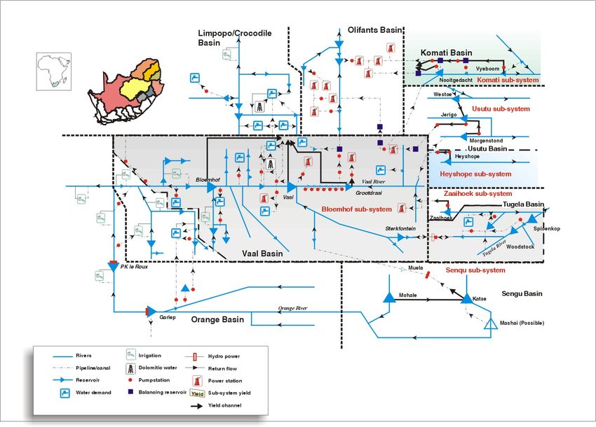
THE INTEGRATED VAAL RIVER SYSTEM PILOT STUDY

C1.      INTRODUCTION

C1.1 BACKGROUND

        Although well-known for its vast mineral resources, South Africa is a land of many contrasts with
        respect to its water resources. With its very low and highly variable rainfall and as a result
        frequent severe cyclic droughts, more attention has been drawn to the efficient management of
        water resources to ensure reliable supplies.

        The region supported by Vaal River System, due to its strategic importance to the country, has
        received much of the attention with respect to water resources availability. The region embraces
        the industrial hub of South Africa and includes portions of some five provinces. It supports a
        number of major water boards (including, Rand Water, Midvaal Water and Sedibeng Water), some
        municipalities (including Witbank and Middleburg), power stations (Eskom), the petrol-chemicals
        industry (Sasol), irrigators (including the Vaalharts Scheme - the largest in the country) and
        number of major mines (platinum, gold and coal producing).

        The region is the first in the country where the water demands have long outstripped the local
        supplies. These insatiable demands have motivated the development of a complex water supply
        infrastructure in the region. The components (or sub-systems) of this complex infrastructure were
        initially separately and independently operated, however, as the requirements increased, they
        became inter-linked and inter-dependent thus culminating in the Integrated Vaal River System
        (IVRS). The system is operated by the Department of Water Affairs and Forestry (DWAF) and
        following the severe droughts of the early nineteen eighties it is analysed on an annual basis.

C1.2 PURPOSE

        The Integrated Vaal River System is one of the selected four pilot systems being examined as a
        prelude to the development of the “Generic Guidelines for Operation and Management of Bulk
        Water Supply Systems under both normal and drought conditions”. Consequently, the purpose of
        this document is to highlight the characteristics and capture the experiences on the operation of
        the Integrated Vaal River System.

        The rest of this document is structured into four sections and three supporting annexures (C1, C2
        and C3). Section C2 provides a list of the main sources of information. The main characteristics
        of the Integrated Vaal River System are described in Section C3. Section C4 sets outs the
        principles and procedures followed in operating the system. Finally, the lessons learnt from
        operations of the system are described in Section C5.

APPENDIX C : VAAL PILOT STUDY                                                                  October 2006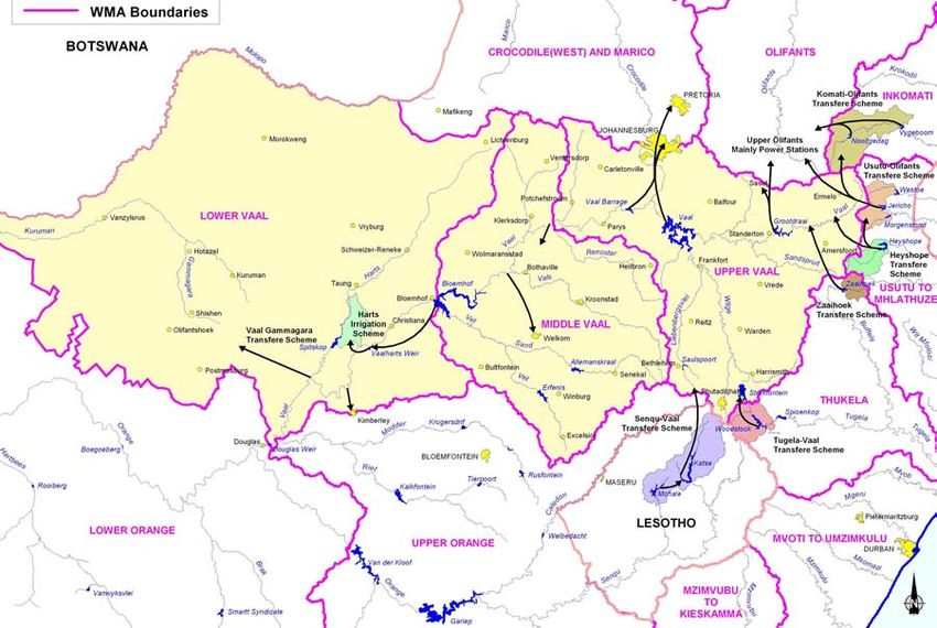
C2

C2.      AVAILABLE INFORMATION

        Information in this document has been extracted from personal discussions with lead practitioners
        of the system, from reports from a number of studies commissioned by the Department of Water
        Affairs and Forestry, and from input by stakeholders at the Vaal System Workshop, held as a part
        of this Study.

        The literature contains descriptions of operating analyses for the Integrated Vaal River System
        dating back to around 1985. Over the years, a process has been implemented which culminates in
        revision of the operating rules on an annual basis.

        Most of the reports specifically relate to the Annual Operating Analysis (AOA) of the system.
        These reports have, in the past, been submitted on regular basis to the Department’s
        Management Committee, Regional Offices, Directorates and appropriate external organisations.
        The following reports have been referenced:

                    DWAF No                                      Document Title
           PC000/00/7889            Analysis of the Integrated Vaal River System, by BKS
           DF//R-System-Vaal-0189   Vaalrivierstelsel :Risko-ontleding van Damstande, 1 Mei 1989 to 30 April
                                    1990
           PC000/00/10090           Vaalrivierstelsel :Risko-ontleding, 1 Mei 1990
           PC000/00/10491           Vaalrivierstelsel :Risko-ontleding, 1 Mei 1991
           PC000/00/11192           Annual Operating Analysis for the Total Integrated Vaal River System
                                    (1992/1993), BKS Inc
           PC000/00/12593           Annual Operating Analysis for the Total Integrated Vaal River System
                                    (1993/1994), by BKS Inc.
           PC000/00/15695           Annual Operating Analysis for the Total Integrated Vaal River System
                                    (1995/1996), by BKS Inc
           PC000/00/19596           Annual Operating Analysis for the Total Integrated Vaal River System
                                    (1996/1997), by BKS Inc
           PC000/00/19897           Annual Operating Analysis for the Total Integrated Vaal River System
                                    (1997/1998), by BKS (Pty) Ltd
           PC000/00/19998           Annual Operating Analysis for the Total Integrated Vaal River System
                                    (1998/1999), by BKS (Pty) Ltd
                                    Assessment of the Eastern Sub-systems with Respect to Releases from
                                    Vygeboom Dam, by BKS (Pty) Ltd
           PC000/00/21398           Evaluation of the Influence of Releases Downstream of Vygeboom Dam on
                                    the Reliability of Supply from the Eastern Sub-systems, by BKS (Pty) Ltd
           PC000/00/21699           Annual Operating Analysis for the Total Integrated Vaal River System
                                    (1999/2000), by BKS (Pty) Ltd.
           PC000/00/21800           Annual Operating Analysis for the Total Integrated Vaal River System
                                    (2000/2001), by BKS (Pty) Ltd
           PC000/00/22101           Assessment of the Influence of Additional Releases from Vygeboom Dam
                                    on the Reliability of Supply of the Eastern Sub-systems (2001/2002), by
                                    WRP (Pty) Ltd
           PC000/00/22201           Vaal River: Continuous Investigations (Phase 2) Annual Operating Analysis
                                    (2001/2002) as part of the Vaal River: Continuous Investigations (Phase 2),
                                    by WRP (Pty) Ltd
           PC000/00/22602           Vaal River: Continuous Investigations (Phase 2) Annual Operating Analysis
                                    (2002/2003) (Phase 2), by WRP (Pty) Ltd
           10-4 AOA2003-2004 V8     Annual Operating Analysis for the Total Integrated Vaal River System
                                    (2003/2004) Vaal River Continuous Investigations (Phase 2), by WRP (Pty)
                                    Ltd

APPENDIX C : VAAL PILOT STUDY                                                                         October 2006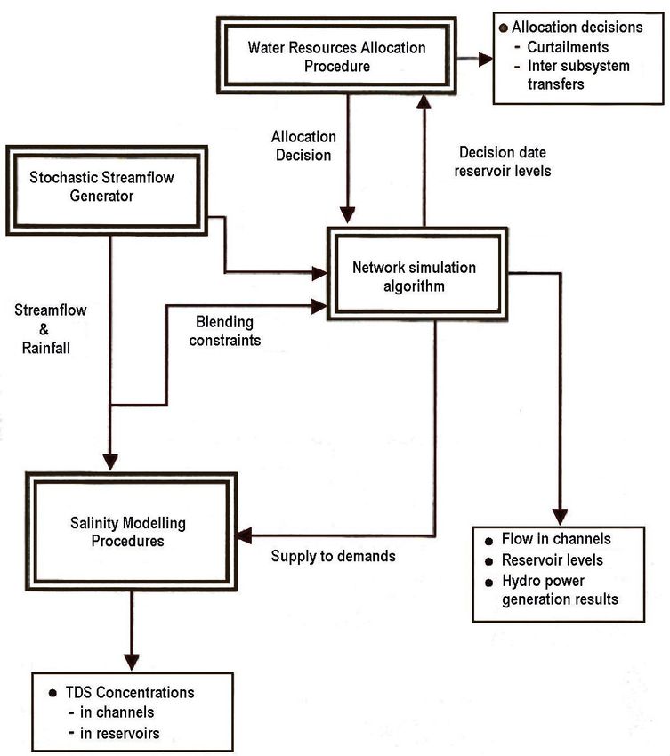
C3
C3. CHARACTERISTICS OF THE INTEGRATED VAAL RIVER SYSTEM
C3.1 DESCRIPTION OF THE SYSTEM
The Integrated Vaal River System supports the industrial heartland of South Africa and includes
portions of five provinces, namely: Free State, Gauteng, Mpumalanga, Northern Cape and North
West. It covers the whole of the Vaal River Basin as far as the Vaal/Riet River confluence and
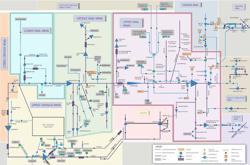
includes both the associated source basins and demand basins. Figure C1 below provides a
geographic presentation of the system and illustrates the various inter-basin transfers, main dams
and demand centres.
Figure C1 Location of the Integrated Vaal River System
C3.2 MAIN COMPONENTS OF THE SYSTEM
The Integrated Vaal River System comprises ten sub-systems, seven transfer schemes, and a
number of internal supply schemes. The main components of the system are briefly described in
Annexure C1. Figure C2 illustrates a schematic presentation of the system, highlighting the sub-
systems, existing and proposed transfer and internal schemes. A more detailed schematic of the
system is provided in Figure C2-1 of Annexure C2.
APPENDIX C : VAAL PILOT STUDY October 2006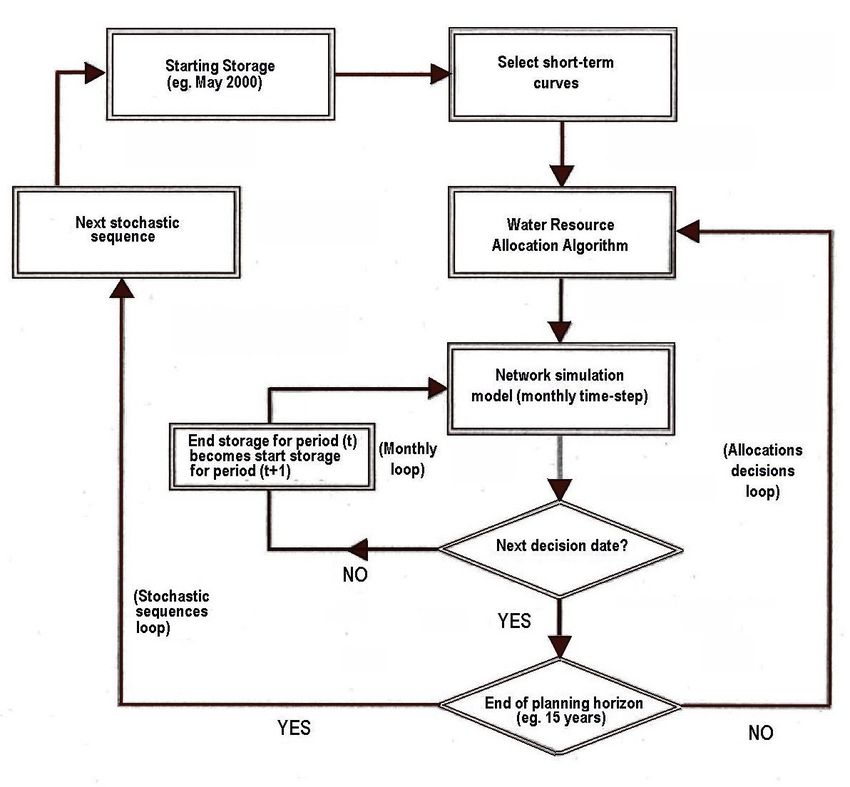
C4

    Figure C2         Schematic of the Integrated Vaal River System

APPENDIX C : VAAL PILOT STUDY                                              October 2006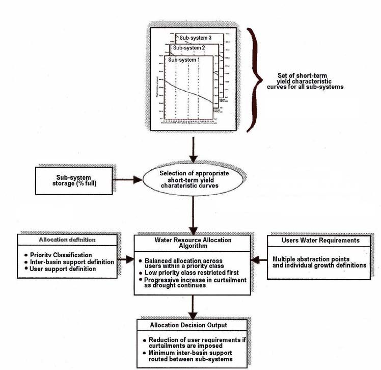
C5

        The main dams of the Integrated Vaal River System are listed in Table C1 and grouped according
        to their location within each sub-system.

         Table C1               Main Dams in the Integrated Vaal River System
                                                                                         Yield at 99 %
             Sub-system                     Major Dam             Gross Capacity
                                                                                          Assurance          Owner
                                                                     (106 m3)
                                                                                          (106 m3/a)
           Komati                   Nooitgedacht                          78                   -         DWAF

                                    Vygeboom                              83                   -         DWAF
                                    Total for Sub-system                  161                100
           Usutu                    Morgenstond                           101                  -         DWAF

                                    Westoe                                61                   -         DWAF

                                    Jericho                               60                   -         DWAF

                                    Total for Sub-system                  222                 71
           Heyshope                 Heyshope                              453                 58         DWAF
           Zaaihoek                 Zaaihoek                              185                 50         DWAF
           Grootdraai               Grootdraai                            356                130         DWAF
           Witbank                  Witbank                               104                 28         Emalahleni LM
           Middelburg               Middelburg                            48                  14         Middelburg LM
           Total for VRES                                                1529                451

           Bloemhof                 Woodstock                             373                            DWAF

                                    Sterkfontein                         2 617                           DWAF

                                    Vaal                                 2 610                           DWAF

                                    Bloemhof                             1 240                           DWAF

                                    Other major dams                      490                            DWAF

                                    Total for Sub-system                 7 330               1560
           Senqu                    Katse                                1 950                           LHDA

                                    Mohale                                938                            LHDA

                                    Total for Sub-system                 2 888               726
           Lower Vaal               Vaalharts Weir                        49                             DWAF

                                    Major dams in Harts                   123                            DWAF
                                    River
                                    Total for Sub-system                  172

           Total for Integrated System                                   11 919              2737

         Note       LM          :             Local Municipality
                    DWAF        :             Department of Water Affairs and Forestry
                    LHDA        :             Lesotho Highlands Development Authority
                    VRES        :             Vaal River Eastern Sub-system

        The sub-systems, Komati, Usutu, Heyshope, Zaaihoek, Grootdraai, Witbank and Middelburg are
        collectively known as the Vaal River Eastern Sub-system (VRES).

APPENDIX C : VAAL PILOT STUDY                                                                                     October 2006
C6
C3.3 STORAGE IN DAMS AND DECISION DATE
The Integrated Vaal River System is located in a summer rainfall area where about 90% of the
rainfall occurs in the summer months. The driest period of the year is from May to September.
The annual operating analysis is performed in May each year (based on dam storage on 28 April)
to determine the medium and long term supply capability of the system. The projected system
curtailment levels are of particularly interest, showing the influence of the starting storages and
other variables on the system’s supply reliability. Some sub-systems are monitored with the
objective to insure a balanced draw down of all reservoirs. Further, the objective is to prepare
reservoir projections for a three year horizon of all major dams in the system. These projections
are used to report on the actual behaviour of the system by plotting the recorded storage levels
onto the projections, using weekly intervals. The dams are at their lowest in April with May being
an appropriate month to make operating decisions.
A typical summary review of the AOA is presented in Annexure C3.
C3.4 THE DECISION SUPPORT SYSTEM
The decision support system comprises the following tools:
• The Water Resources Yield Model (WRYM)
The WRYM, configured for the IVRS is used to simulate the steady state operation of the
integrated system or sub-systems, including the effects on the yield from changes in land-
use, system operating rules, and/or the construction of additional dams or other water
resource infrastructure.
Important and useful outputs from the WRYM are sets of Short Term Characteristic Curves
(STCCs) which it is able to produce. The characteristic curves developed within this model
are currently used to manage the operation of the system. These curves are used to reflect
the short term yield capability as a function of the live storage available in the dams of a sub-
system for multiple assurances of supply to water user sectors.
• The Water Resources Planning Model (WRPM)
The WRPM is configured for the total IVRS and is used for development planning and annual
operating analysis. The model takes expected growth in water demands, changes in return
flows, and changes in surface water runoff (as a result of land-use change) into account. It is
also used during periods of anticipated drought conditions to assess (at a pre-determined
decision date) how the system should be operated during the following year to ensure
required reliabilities of supply. Current water levels in the dams of the system and expected
increases in water demands over a planning horizon of about five years are used to assess
whether or not, and at what level of severity, restrictions will be required.
The IVRS model also simulates the salinity (Total Dissolved Solids) regime of most parts of
the system and is capable of evaluating the impact of blending and dilution operating rules.
This capability makes it possible to assess the interdependencies between operating rules
and water quality through the analysis of scenarios.
APPENDIX C : VAAL PILOT STUDY October 2006C7
• The Vaal Hydrological Information Management System (VHIMS)
The VHIMS, also currently referred to as the Water Resources Yield Model Information
Management System (WRYM-IMS), is under development. The objective of the software is
to handle information management for both the WRYM and WRPM, and eventually other
water resource models. The development is undertaken in phases and the current version
incorporates the functionality to manage the data (input and results) of the Water Resources
Yield Model.
C3.5 WATER QUALITY CONSIDERATIONS
Salinity is the most important water quality variable in the Vaal River System and the WRPM for
the IVRS was therefore configured and calibrated to simulate salinity (Total Dissolved Solids).
With this capability the WRPM is used to evaluate the impact of operating rules on blending,
dilution and preferential sources of supply. With the salinity modelling feature integrated with the
quantity modelling features, it is possible to simulate the impact that salinity related rules have on
the reliability of supply of the system.
C3.6 GROUNDWATER USE
The use of groundwater resources is in general indirectly accounted for in the calibration of the
hydrological models and therefore reflected in the hydrological database. Groundwater is widely
used for water supply in areas remote from the rivers and serves as a valuable local water
resource to various towns and agricultural activities. Areas where dolomite aquifers are present
represent a large potential resource, such as the Zuurbekom Aquifer which is utilised by Rand
Water at about 3,6 million m3 per annum. This supply is taken into consideration in the operating
analysis by means of a constant supply time series. The dynamics of the aquifer is however not
simulated explicitly in the WRPM.
C3.7 ECOLOGICAL RESERVE
The Ecological Reserve has not been determined for the IVRS as a whole and is therefore not
implemented in the operating analysis. There are however compensation releases made from
several dams in the system which are included in the operating analysis. Preliminary analysis has
shown that the Ecological Reserve could potentially have a significant impact on the water
availability to the other water users. Careful consideration and planning would therefore be
required to select the appropriate management class for the Ecological Reserve.
C3.8 INTERNATIONAL OBLIGATIONS
There are no direct international obligations that affect the operation of the IVRS. The system is
however dependent on the transfer from the Lesotho Highlands Water Project (LHWP), currently
consisting of Katse and Mohale Dams, Matsoku Diversion Weir and transfer tunnels diverting
water into Vaal Dam. The transfer of water from the LHWP is governed by a Treaty which
prescribes what volumes will be transferred on an annual basis.
The IVRS incorporates the LHWP water resource components as part of the system and the
agreed transfer volumes are implemented in the annual operating analysis.
APPENDIX C : VAAL PILOT STUDY October 2006C8
C4. PRINCIPLES AND PROCEDURES FOR DERIVING OPERATING RULES
C4.1 OPERATING PRINCIPLES
Operating as an integrated system
An important characteristic of the Integrated Vaal River System is the inter-dependencies that
exist due to the numerous inter-basin transfers which form a complex network of inter-linked
reservoirs located in catchments with different hydrological characteristics. This necessitates that
the operating rules developed, be done so in an integrated manner to ensure that the effects of
operating rules are evaluated in an integrated system context. In so doing, the behaviour of all the
components of the water resource system are evaluated and monitored. Therefore, as a general
operation principle, the Integrated Vaal River System must be operated as an integrated system
irrespective of who owns or operates each individual component of the system.
Maintaining assurance of supply
The primary objective of the operation of the Integrated Vaal River System is to maintain the
assurance of supply to all water users receiving water from the system. This is achieved by
transferring water between sub-systems with the aim of balancing the drawdown of the reservoirs
during drought periods and preventing spillage and wastage from the system during wet periods.
The main indicator variable, produced by the Integrated Vaal River System model and used for
operation planning decisions, is the future projection of the probability of restrictions for the
system.
Cost saving operating rules
As a secondary objective, consideration is also given to the implementation of cost saving
operating rules during wet hydrological conditions when the dams are full. This entails reducing
the pumping of water through the inter-basin transfers for limited periods with the proviso that the
long term assurance of supply is not jeopardised.
Restriction of demands
The operations and development planning of the Integrated Vaal River System is based on the
principle that water requirements are restricted during severe drought events. The objective of
restrictions is to reduce the supply to less essential water use in order to conserve water, over the
longer term, as a measure to protect the assurance of supply for more essential use. The basis
on which the restrictions are implemented is defined by means of a user priority classification
definition which specifies the portion of each user sector’s demand that is allocated to the different
assurance of supply categories. Table C2 presents typical priority classifications, assurances of
supply and curtailment levels for the water use sectors.
APPENDIX C : VAAL PILOT STUDY October 2006C9
Table C2 Priority classifications, assurance of supply and curtailment levels
User priority classification
(assurance of supply)
Low Medium High
User
(95 %) (99 %) (99.5 %)
Percentage of water demand NOT guaranteed
(at increasing levels of curtailment)
1 Domestic 20 30(1) 50(2)
2 Industrial 10 30 60
3 Strategic industries 0 0 0
4 Irrigation 20 30 50
Curtailment levels: 0 1 2 3
Note: (1) 70% of the demand for domestic water in the Vaal System can be supplied with an assurance of at least 99%
(2) A proportion of 50% of domestic water in the Vaal system can be supplied at the high assurance.
When restrictions are imposed, low priority users are restricted first, followed by the medium and
then the high priority users.
Curtailment level “0” implies that all requirements are supplied. At a curtailment level of “3”, all
users except for strategic industries are curtailed, implying a total failure of the system. If
curtailment level “1” is used as an example, the curtailment of the various users will be as
illustrated in Table C3.
Table C3 Example of curtailment at level 1
User Curtailment
(% of total requirement)
1 Domestic 20%
2 Industrial 10%
3 Strategic industries None
4 Irrigation 20%
C4.2 ANALYSIS TECHNIQUES
Water resources allocation
Figure C3 shows the basic components that make up the Water Resources Planning Model
(WRPM) and illustrates the information linkages and basic output that can be produced by the
model. As indicated, the Water Resources Allocation Algorithm (WRAA) receives, on each
decision date, the storage state of the reservoirs in the system and communicates the allocation
decision back to the Network Simulation Algorithm.
The main output from the WRAA is the allocation to users in the system which only deviates from
the imposed requirements during drought periods when curtailments are implemented.
APPENDIX C : VAAL PILOT STUDY October 2006C10
Figure C3 Model components of the Water Resources Planning Model
The allocation decision also involves calculating the volume of support required between sub-
systems and in some cases may be used (depending on the definition) to impose minimum flow
limits on inter-basin transfer channels of the system network. Figure C4 gives a more detailed
schematic representation of the allocation algorithm and illustrates the main aspects of the
procedure as described below.
APPENDIX C : VAAL PILOT STUDY October 2006C11
Figure C4 Schematic representation of the Water Resources Allocation Algorithm
Scenario analysis
The method applied to determine the influence a particular operating decision has on the projected
supply capability of the system is scenario assessments where the system response is measured
on the basis of risk or probability. The probability distribution of any component or variable in the
water resource system can be evaluated and are usually presented as projections of monthly or
annual box plots covering the planning period. It has been noted that the Vaal River System has a
historical critical period in excess of nine years and as such it is important to undertake these
assessments for periods not less than fifteen years. This ensures that the long-term effect of
starting conditions or decisions taken in the first year are observed in the results of the projection
analyses.
The most important variable used for decision-making is the probability of curtailments, which
represent the system’s supply capability as projected into the future along with growing water
requirements and changing system configurations. The procedure applied to obtain the projected
probability of curtailments is illustrated in Figure C5 and shows the main iteration loops of the
model. The stochastic loop is usually circled a thousand times and one allocation decision is
taken in a year for the Vaal River System. This means a thousand curtailment results are
generated for a particular year in the planning period of which the distribution is presented
graphically as box plots.
APPENDIX C : VAAL PILOT STUDY October 2006C12
Figure C5 Procedure to derive the projected probability of curtailment
C4.3 OPERATION PROCEDURE
Institutional Arrangements
Meetings with selected stakeholders are held annually where the results of the operating analysis
are discussed and if necessary alternatives proposed. The stakeholder organizations that are
represented at this meeting are listed below:
Department of Water Affairs and Forestry Directorates:
• National Water Resource Planning
• Option Analysis
• Water Resource Planning System
• Gauteng Regional Office
• Free State Regional Office
• Northern Cape Regional Office
Other stakeholders:
• Eskom
• Rand Water
• Sasol
APPENDIX C : VAAL PILOT STUDY October 2006C13
During periods when restrictions are implemented, DWAF has in the past formed a water users
forum consisting of a wide group of stakeholders. The forum would meet regularly to discuss the
successes of achieving (or not) the target reductions in use and report on the status of the water
resources. Typically all the water user sectors would be represented at these meetings.
Given that several catchment forums have been established in the Vaal River System over the
past five years, these forums will certainly in future play a prominent role in the implementation
and monitoring of restrictions in the system.
The AOA involves analysis of various scenarios where the operating rules are changed and the
effects thereof assessed by comparing the behaviour of the system. The results of the scenarios
are discussed at the annual meeting referred to above. The water resource management from
DWAF, in consultation with the stakeholders, then select a scenario according to which the system
will be operated. DWAF officials then communicate these decisions to the operating staff who
then implement the rules.
Operating approach
The operating rules involve controlling the transfer of water between reservoirs and sub-systems
and the drawdown of dams in the system. Two main trigger mechanisms are used to control the
transfer volumes and timing of transfers, as described below:
• Dam levels
Trigger levels in dams are used to control the event when transfer should commence or
cease. The objective of such triggers is to prevent a dam from spilling or to reserve water
for use by local or other users than those benefiting from the transferred water.
• Short term yield capability of sub-system
The second operating rule mechanism is based on a comparison of the short term yield to
the water requirements of the sub-systems. In general, when the balance is negative
(demand exceeds supply) support is requested by one sub-system from another and, if it is
available, transfer occurs. The volume of water transferred varies and is determined by
either the required shortfall or the available surplus.
The short-term yield versus demand balance referred to above, is based on stochastic
short-term yield characteristic curves for each sub-system. These curves reflect the short-
term yield capability as a function of the live storage that is available in the dams of a sub-
system and make provision for multiple assurances of supply to water user sectors. The
detailed operation of each sub-system is presented in Annexure C2.
The application of the above decision procedure along with the stochastic streamflow
generator allows for scenario analysis to be undertaken, as briefly described below.
Operating planning
The operation of the Integrated Vaal River System is governed by an operating rule planning
activity, commonly referred to as the Integrated Vaal River System Annual Operating Analysis.
This planning activity involves, among other things, using the Integrated Vaal River Model as a
decision support system to analyse and assess different scenarios of operation. The results are
presented to DWAF and bulk water users who then make decisions on what the appropriate
operating rules should be for the subsequent twelve months.
APPENDIX C : VAAL PILOT STUDY October 2006C14
The system analyses are usually undertaken using the first of May’s starting storage levels in the
dams and updated system data. The updated system data includes revised water requirement
projections, implementation dates of maintenance activities and operating rule definitions that
define a particular scenario. During periods of drought the analyses may be repeated several
times in the year to investigate alterations to the operating rule as the need arises.
Implementation process
The operating decisions and/or restrictions are implemented through a process which includes the
following :
• Initially “warnings” of possible restrictions are communicated to the water users and the
users are requested to save water.
• Once the decision is taken to implement restrictions, supported by analysis to show it is
necessary, it is published in the government gazette.
• At that time, the user forum is activated and meetings are conducted to inform the users of
the restrictions and to monitor how the restriction targets are met.
• At local authority level, the need for restrictions and the “rules” are implemented through
municipal regulations and largely left to each local authority.
• In the last drought, Rand Water initiated a publicity campaign including newspaper
advertisements and articles in newspapers as well as television advertisements.
• DWAF would also have “high ranking” officials on national television and radio explaining
the situation and informing the public of the restrictions.
• During the last drought, some of the graphs and output information from the analysis were
presented on the national news in support of the request for restrictions.
APPENDIX C : VAAL PILOT STUDY October 2006C15
C5. CURRENT OPERATION OF THE INTEGRATED VAAL SYSTEM
C5. 1 PURPOSE OF ASSESSMENTS
Since 1989, operating analyses were undertaken on an annual basis and in general the purpose
was to provide answers with respect to the following aspects:
• Should restrictions be implemented over the following twelve months? This is only required
during drought periods when the storage levels in the reservoirs of the system are low.
• Could reduced inter-basin support be tolerated for a twelve-month period? During periods
when the system reservoirs are exceptionally full the question arises if cost savings could
be achieved through reduced pumping for a year without jeopardising the long-term
reliability of supply.
• What blending or dilution operating rule should be applied? Different salinity related
operating rules have been identified and applied in the past to support the water
requirements of Rand Water and the users downstream of Vaal Barrage. These analyses
aim to lower the TDS (Total Dissolved Solids) concentration of water supplied to the users
but with limited impact on the projected supply capability.
• Assess the influence that the starting storage volumes have on the implementation date of
subsequent augmentation options.
C5.2 ANNUAL OPERATING ANALYSIS
General approach
The general approach adopted in the annual operating analysis includes water balance analysis
for the current season and an assessment of the integrity of the system for planning purposes. In
addition, the augmentation needs and impacts of water demand management are identified. (A
summary of a typical review is presented in Annexure C3). Analysis is undertaken at the
beginning of May for the forthcoming 12 months, three years and 20 to 25 years. A five year
period has been considered for demand management. The aspects considered under each of
these time frames are discussed in the following section in an attempt to develop a generic
description of the processes as undertaken in these analyses.
Development planning and operational analysis
Traditionally operating analysis has also included analysis for development planning purposes. For
example, the 1996/97 operating analysis includes demand projections for three purposes namely;
operating analysis, scheduling augmentation and evaluation of demand management. This section
highlights how development planning was incorporated into operational analysis.
Long-term planning focuses on the disparities between system yield and water requirements as
well as system yield and capacity of treatment and conveyance infrastructure. Planning analysis
is seldom concerned with the optimisation of current operations and assumes that the current
conditions apply for all planning years. It tests the system integrity from a number of hypothetical
APPENDIX C : VAAL PILOT STUDY October 2006C16
but possible scenarios. For example, in the Eastern Sub-system, planning analysis assumes that
the following takes place when shortfalls occur :
• Middelburg sub-system (deficit imposed on Witbank sub-system);
• Witbank sub-system (deficit imposed on Grootdraai sub-system);
• Komati sub-system (deficit imposed on Usutu sub-system);
• Usutu sub-system (deficit imposed on Heyshope sub-system);
• Grootdraai sub-system (deficit imposed on Zaaihoek sub-system);
• Zaaihoek sub-system (deficit (only Grootdraai portion) imposed on Heyshope sub-system);
As such, the deficit calculated at Heyshope is representative of the total augmentation requirement
of the Eastern Sub-system.
A number of medium to long-term issues are also covered in operating analysis. For example, in
the 2001/2002 the following were also covered:
• projected storages of the Grootdraai Dam and requirements for augmentation of the Eastern
Sub-system;
• impact on pumping costs of reduced inter-basin transfers from the Heyshope and Zaaihoek
Dams to the Grootdraai Dam over a planning horizon of five years;
• impact of the revised implementation programme for the Mohale Dam and its transfer tunnel;
• evaluation of impacts of projected curtailments for the period 2001 to 2030 with existing and
planned infrastructure (Phase 1 of Lesotho Highlands Water Project).
Scenario tests conducted on the 2001/2002 analyses evaluated the impact of additional Komati
Irrigation Board (KIB) releases and the changed Komati operating rules. Such scenario tests are
actually done as separate more detailed studies. For example, the impact of additional the Komati
Irrigation Board releases is addressed in the following reports :
• Assessment of the Additional Releases from the Vygeboom Dam on the reliability of Supply
of the Eastern sub-systems (2000/2001)
• Assessment of the Additional Releases from the Vygeboom Dam on the reliability of Supply
of the Eastern sub-systems (2001/2002)
Adjustment of criteria of reliability of supply is also undertaken as separate studies. For example,
on the Komati Sub-system the “Reassessment of the Influence of Operational Decisions
Regarding the Komati on the Reliability of Supply of the Western Sub-systems" (1999/2000)
resulted in revision and adoption of criteria to ensure that the Nooitgedacht and Jericho Dams are
not emptied at a risk exceeding 0.5%.
Future augmentation schemes are also reviewed as part of the annual operating analysis.
Consideration is given to the impoundment and start delivery dates. For example, the 2000/2001
analysis considered augmentation dates for the Lesotho Highlands Water Project as follows :
APPENDIX C : VAAL PILOT STUDY October 2006C17
Scheme name Impoundment date Start delivery date
Lesotho Highlands Water Project Phase 1a
Katse dam and tunnel Oct 1995 Jan 1998
Motsoku weir and tunnel - Jan 2001
Lesotho Highlands Water Project Phase 1b
Mohale dam and transfer tunnel (initial Oct 2001 Jan 2003
schedule)
In addition to the above dates the 2001/2002 analysis considered the following augmentation
dates for the LWHP as follows:
Scheme name Impoundment date Start delivery date
Lesotho Highlands Water Project Phase 1b
Mohale dam and transfer tunnel (option1) Oct 2002 Feb 2004
Mohale dam and transfer tunnel (option2) Feb 2003 Feb 2004
Guiding principles objectives and strategies
In the current methodology, deficits (shortfalls) are dealt with in a cascaded manner until support is
required from the Heyshope sub-system. The strategy is to use Heyshope as backup support.
One of the benefits of the annual operating analysis frequently referred to is the decision made to
lift water restrictions in September 1988. This was before the start of the following rainy season.
As each drought condition is different there is need to review the past experiences in terms of the
following:
• Agreed principles for sharing the limited available water,
• the operational objectives for each sub-system, and
• the strategies put in place.
As a result of diligent augmentation planning and water resources development undertaken in the
past to maintain risk of curtailments at acceptable levels, restrictions are only required during
severe drought periods.
General approach on projecting water requirements
Water requirement projections cover the forthcoming year and a twenty to thirty year planning
horizon. Water balance information is provided for at least two years during the planning period.
Current practice utilises a spreadsheet model to conduct annual water balance projection
calculations, providing a first order estimate of future augmentation requirements for a sub-system.
The balance projection calculation is based on an annual water resources availability (yield)
assessment and projected water requirements. For a particular year, the total water requirement in
a sub-system is subtracted from the locally available yield, in order to determine whether it is in
surplus or deficit. Should a deficit occur, that deficit is “imposed” on a second sub-system, in
accordance with the capability of the second sub-system to support the sub-system in need.
APPENDIX C : VAAL PILOT STUDY October 2006C18
The 1996/97 operating analysis demand projection applied the same scheduling augmentation
until 1997, beyond which the most probable TR134 projections were applied. These projections
were obtained from the Report of the Committee of Water Demands in the Vaal River Supply
Area, forecast to 2025 (DWAF, 1988). Eskom provided projected water demands for its power
stations for each point of abstraction. The demands were different from those in the Vaal
Augmentation Planning Study Report. Return flows were calculated as part of the analysis. It was
assumed that through demand management, a 10% reduction in demand could be achieved
spread over five years. This scenario showed a shift in the violation of curtailment criteria from
2004 to 2010, resulting in postponement of the implementation of the Southern Tugela-Vaal
Transfer Scheme by six years. Scenarios for the durations required to undertake repairs to the
Woodstock-Sterkfontein canal considered a probability of curtailment equal to 5%.
Investigations by BKS in 1998 showed that make-up releases from the Vygeboom Dam for the KIB
releases cause assurance of supply in the Komati and Usutu sub-systems to deteriorate to
unacceptable levels. The operating rule on inter-basin transfers was changed to increase
transfers to the Komati and Usutu sub-system and at the same time ensure that pumping costs
were kept to a minimum. The inter-reservoir operating rule for the Usutu sub-system reservoirs
was adjusted to transfer water earlier from Morgenstond to Jericho Dam to ensure that water foes
not remain in Morgenstond when Jericho Dam is empty. The 1999 annual operating analysis
indicated violation of the reliability criteria for the Nooitgedacht Dam leading to revision of inter-
sub-system rules on water transfer to the Komati sub-system. A new criterion that Nooitgedacht
and Jericho Dams may not be emptied at a risk of 0.5% was implemented. The 1999 study also
looked at the implications on pumping costs and resulted in a revised Komati (1999) operating
rule, which defined the water to be transferred from the Usutu sub-system.
The 1998/99 annual analyses also applied demand projections from the Vaal River System
Analysis Update Study conducted in March 1997 as well as the TR134 projections. In August
1997, Eskom provided future projections for their water requirements for thermal power stations.
Historical demands were applied fro 1995 to 1997 and projections were done for 1998 to 2030.
The 2000/2001 annual analyses applied the June 1999 Eskom water requirement projections.
The Midvaal Water Company provided updated figures which were 12% lower than their 1999
projection. The 2000/2001 analysis applied information from the report Future Demand and
Return Flows (BKS 1994) but later updated to the 1997 Vaal River System Analysis Update Study.
The 2001/2002 annual operating analysis applied projections of future urban and industrial
requirements from the NWRS and its water usage database. Water requirement projections for
Midvaal Water Company (April 2001) and Sedibeng Water (April 2001) provided on the dates in
brackets were applied. Two possible scenarios for the Rand Water requirements were analysed;
namely August 2000 Rand Water projections and projections from the NWRS database. Eskom,
ISCOR and SASOL provided their own projected requirements.
C5.3 OPERATIONAL LESSONS LEARNT
The following operational lessons have been learned:
• Annual operating analysis planning and operational scenarios are to be assessed.
• Related studies and documents are identified to support the scenarios selected.
APPENDIX C : VAAL PILOT STUDY October 2006C19
• Recommendations are made for new studies.
• The decision date for the IVRS is 1 May of the current year.
• Actual performance of each dam is compared against three yearly projections.
• Reservoir storage levels recorded at end of April (28 April, 1 May) are applied as the starting
conditions for the following annual analysis.
• Review storage status and water requirements against current assurance of supply criteria.
Implications on the short and medium-term operating regime are assessed. Options for
analysis are identified. These include augmentation plans.
• User requirements are updated or re-confirmed. For example Eskom, Rand Water Sasol-
Secunda are approached for revised figures of their annual requirements.
• Data on compensation releases from Vygeboom, Zaaihoek, Grootdraai, Katse and Mohale
Dams is obtained.
• The WRPM system configuration is reviewed and updated.
• Any additional analysis identified is undertaken.
The following appear to be the main drivers for the operating analysis of the IVRS:
• Demand projections,
• Court orders on releases,
• IFR releases,
• Blending requirements,
• Reduction of pumping costs,
• Demand management.
APPENDIX C : VAAL PILOT STUDY October 2006ANNEXURE C1 : DESCRIPTION OF MAIN COMPONENTS OF THE SYSTEM
C1-1

        A brief description of each of the sub-systems within the IVRS is given in this section.

C1-1    Lower Vaal Sub-system
        There are three main dams in this sub-system namely Wentzel, Taung and Spitskop with a
        combined storage capacity of 123 million m3. They are all located in the Harts River and their
        function is to supply local water requirements. The Vaalharts Weir, with a capacity of 49 million
        m3, is a regulation structure that diverts water into the canal system feeding the Vaalharts
        Irrigation Scheme. It also releases water for the downstream users along the Vaal River.

C1-2    Bloemhof Sub-system
        The Bloemhof Sub-system consists of four large dams namely Bloemhof, Vaal and Sterkfontein in
        the Vaal River catchment, and Woodstock Dam in the upper part of the Thukela River catchment.
        These dams have a combined capacity of 6 840 million m3. A major component of the sub-system
        is the Thukela-Vaal Transfer Scheme, which transfers water from Woodstock Dam via Driel
        Barrage into Sterkfontein Dam at a nominal capacity of 20 m3/s or 631 million m3/annum. The
        transfer from the Senqu Sub-system into Liebenbergsvlei and thence into Vaal Dam, contributes
        significantly to the water resources in the system and represents the supply augmentation from
        Phases 1A and 1B of the Lesotho Highlands Water Project. There are various other major dams
        in the sub-system, with an additional total storage capacity of 490 million m3. These dams are
        located on tributary rivers in the incremental catchment between Vaal and Bloemhof Dams, and
        their function is to support local water requirements of several irrigation schemes as well as urban
        water users.

        Rand Water’s abstractions, the largest water use from the Integrated Vaal River System, are from
        the Vaal Dam and Vaal Barrage. Other notable abstractions are Midvaal Water and Sedibeng
        Water, both abstracting water from the Vaal River downstream of Vaal Barrage.

C1-3    Senqu Sub-system
        This sub-system is within the boarders of Lesotho and represents the water resource components
        of Phase 1A and 1B of the Lesotho Highlands Water Project, consisting of Katse and Mohale
        Dams, Matsoku Weir and connecting conveyance and transfer tunnels delivering water into
        Liebenbergsvlei River, a tributary of the Vaal River, which feeds Vaal Dam.

C1-4    Grootdraai Sub-system
        The main component of this sub-system is Grootdraai Dam, which also forms the hub of the water
        supply system for the Vaal River Eastern Sub-system. Grootdraai Dam regulates a significant
        portion of the Upper Vaal River catchment’s runoff, and receives transfer water from the Heyshope
        and Zaaihoek sub-systems. The main water users that are supplied from the sub-system include
        Thutuka Power Station, Sasol 2 and Sasol 3, as well as irrigation and several small urban users.

C1-5    Heyshope Sub-system
        Heyshope Dam lies on the Assegaai River, which is a tributary of the Usutu River. Only minor
        water requirements are supplied directly from the water resources of the Heyshope Sub-system.
        The main function of the sub-system is to augment the water supply in the Grootdraai and Usutu
        sub-systems.

APPENDIX C : VAAL PILOT STUDY                                                                      October 2006
C1-2
C1-6 Zaaihoek Sub-system
The Zaaihoek Dam regulates the runoff of the Slang River, which is a tributary of the Buffalo River
and forms part of the catchment of the Thukela River. The main function of Zaaihoek Dam is to
supply the water requirements of Majuba Power Station and to support Grootdraai Dam as a
secondary priority.
C1-7 Usutu Sub-system
The Usutu Subsystem consists of Morgenstond, Jericho and Westoe Dams (combined capacity of
222 million m3) as well as the Churchill Diversion Weir. These are all linked through gravity and
rising conveyance systems feeding Jericho Dam to supply water to several Power Stations and
augment the water supply in the Komati Sub-system. An additional rising main pipeline has
increased the transfer capacity from Morgenstond to Jericho Dams.
C1-8 Komati Sub-system
This sub-system contains two major dams namely Nooitgedacht and Vygeboom, located on the
Komati River, which provides most of the regulating storage (161 million m3) of the Komati Sub-
system, with support from the diversion structures on the Gladdespruit and Gemsbokhoek Rivers.
Most of the water requirements is from power stations and is supplied through pumping. A
significant volume of water is used by forestry developments (afforestation) occurring mainly in the
catchment of Vygeboom Dam. This is estimated at 24 million m3/annum or 24% of the Mean
Annual Runoff of that particular incremental catchment.
C1-9 Witbank and Middelburg Sub-systems
Witbank Dam regulates the runoff from a highly developed catchment, which contains various coal
mining operations as well as minor irrigation and agricultural activities. The function of the dam is
to support the urban water requirements of the Emalahleni Local Municipality. Obligatory releases
are also required to support Loskop Dam. Inter-basin transfer to this sub-system is possible from
the Grootdraai Sub-system by means of releases from Trichardtsfontein Dam. These releases are
conveyed via the river channel into Witbank Dam. This transferred water can also be supplied to
Duvha Power Station from Witbank Dam through the Naaupoort Pump Station. The sulphate
concentration of the water in Witbank Dam, resulting primarily from the coal mining operations in
the catchment, is a constraint on the volume of water that can be used from this source to supply
the Duvha Power Station.
Middelburg Dam is the main water resource infrastructure component within the sub-system and
has the function of supplying Middelburg Local Municipality. There are also obligatory releases for
Loskop Dam. A pipeline constructed in 1998 transfers water from Witbank Dam to Middelburg
Dam, effectively giving the users in this sub-system access to water from the Witbank, Grootdraai,
Heyshope and Zaaihoek sub-systems.
APPENDIX C : VAAL PILOT STUDY October 2006ANNEXURE C2 : OPERATION OF THE SUB-SYSTEMS
C2-1

        For orientation purposes, refer to Figure B2-1 which shows the schematic layout of the Integrated
        Vaal River System. The operation of the sub-systems is described hereafter.

C2-1    Lower Vaal Sub-system
        The Lower Vaal Sub-system has limited local water resources and most of the water requirements
        in the sub-system are supplied through releases from Bloemhof Dam. Vaalharts Weir, located
        downstream of Bloemhof Dam, serves as a control structure to divert water into a canal system
        that feeds the Vaalharts Irrigation Scheme. Water is also discharged into the Vaal River, mainly
        for irrigation and some urban water users.

        The predominant water use in the sub-system is irrigated agriculture. Of the urban and industrial
        water requirements, the water supply to Kimberley is the most significant. Due to the relatively
        long river reach downstream of Bloemhof Dam and Vaalharts Weir, significant quantities of
        consumptive evaporative losses and non-consumptive operating losses are associated with
        releases in the river system.

C2-2    Bloemhof Sub-system
        The description of the operation of the Bloemhof Sub-system is provided according to the main
        storage structures and abstractions, ordered from the most downstream to the most upstream.

        Bloemhof Dam is the most downstream regulating storage structure in the sub-system. It serves
        as the primary water source to supply the water requirements in the Lower Vaal Sub-system.
        Releases from the dam are made in accordance with a daily schedule of water requirements that
        is updated on a weekly basis.

        Since the water requirements supplied from Bloemhof Dam are more than the supply capability
        (incremental yield) of the dam, releases are made from Vaal Dam (via Vaal Barrage) once the
        water level in Bloemhof Dam reaches it’s minimum operating level.

        Sub-catchments within the Bloemhof Sub-system contain various dams and water abstractions all
        impacting on the supply capability of the dam. There are no release obligations from these sub-
        catchments, with the result that only spills from the dams and unutilised runoff flows into Bloemhof
        Dam.

        Releases from Bloemhof Dam are driven by the water requirements of the Vaalharts Irrigation
        Canal System. Water released from Bloemhof Dam for irrigation is fed into the canal system at
        the downstream Vaalharts Weir.

        Notable abstractions in the river reach between Vaal Barrage and Bloemhof Dam include Midvaal
        Water, Sedibeng Water and abstractions for irrigation. These abstractions are supported with
        releases from Vaal Barrage (supported also by Vaal Dam). The releases from Vaal Barrage are
        driven by either these downstream water requirements or through excess water in the Vaal
        Barrage (spills) as a result of the dilution operating rule. The dilution operating rule has the
        purpose of maintaining the Total Dissolved Solids (TDS) concentration of the water in the Vaal
        Barrage at a specified level by means of freshening releases from Vaal Dam. This is necessary
        due to the high salinity (TDS) content of the underground mine water that is pumped out of the
        gold mines into the river system, and from surface runoff from the highly urbanised areas in the
        incremental catchment of the Vaal Barrage.

APPENDIX C : VAAL PILOT STUDY                                                                     October 2006
C2-2
Other alternative blending and dilution operating rules are also considered during the Annual
Operating Analysis. These are evaluated with respect to the long-term assurance of supply and
the TDS concentration of the water supplied to all the users.
The operation of Vaal Dam is driven mainly by the downstream releases and the water abstracted
by Rand Water. Releases from Sterkfontein Dam are usually only made if Vaal Dam’s storage is
depleted to the minimum operating level, or if Sterkfontein Dam is full and there is still water
available in Woodstock Dam for transfer via the Thukela Vaal Transfer Scheme, as further
explained hereafter.
The operation of the Thukela-Vaal Transfer Scheme is such that water is released from
Woodstock Dam to Driel Barrage from where it is pumped and conveyed to the lower level of the
Drakensberg Pump Storage Scheme. From here it is further pumped into Sterkfontein Dam
located at the higher elevation on the escarpment. The normal operating rule, with the objective of
maximising yield in the system, is to continue the transfer until Vaal and Bloemhof Dams are full.
However, during wet hydrological conditions when the dam levels are relatively high or in the case
where excess supply capability in the system is present, the transfer volume is reduced to save
pumping costs. These deviations are only implemented if it is proven, through scenario analysis,
that the long term assurance of supply will not be jeopardised.
Transfers from the Senqu Sub-system (Lesotho Highlands Water Project) are governed by the
Treaty agreements between South Africa and Lesotho. This agreement stipulates a schedule of
annual volumes that have to be transferred which increase over time until the so-called “Nominal
Annual Yield” of the Lesotho Highlands Water Project is reached.
C2-3 Senqu Sub-system
The elevation of the components of the sub-system that are located in the Lesotho Highlands
makes it possible to gravity feed water through tunnels from Matsoku Weir and Mohale Dam into
Katse Dam, from where it is further transferred to South Africa via a delivery tunnel, discharging
water into Liebenbergsvlei River a tributary of the Vaal River upstream of Vaal Dam.
Compensation releases to maintain the ecological functions of the downstream rivers are made
from all three structures. The operating rule of the releases ensures variability in the downstream
flow by allowing for maintenance flow freshets during wet hydrological conditions and base flow
released during drought conditions. The aim is to mimic the natural cycles and thereby maintain
the ecological triggers that would have occurred under natural conditions.
C2-4 Grootdraai Sub-system
Water is pumped via pipelines and canals from Grootdraai Dam to supply Sasol 2 and Sasol 3 and
to transfer water to the Olifants (Witbank Dam) sub-system. The transfers are discharged into
Trichardtsfontein Dam in the upper reaches of Trichardtspruit. From here water is released to
Witbank Dam via Rietfontein Weir, and pumped to Middelburg Dam if required. Sasol’s primary
source of supply is Grootdraai Dam, which in turn receives water from Heyshope and Zaaihoek
Dams. Water for Kendal, Kriel and Matla Power Stations is partly supplied from Rietfontein Weir
that is supported from Grootdraai Dam. Duvha Power Station can be supplied from Grootdraai
Dam via Trichardtsfontein Dam, Rietspruit Weir and Witbank Dam. The volume of water that can
be utilised through this transfer option is limited due to the high sulphate concentrations of the
APPENDIX C : VAAL PILOT STUDY October 2006C2-3
water in Witbank Dam. This support option is only utilised if the Komati, Usutu and Heyshope sub-
systems can not fully supply the water requirements in the Komati sub-system.
C2-5 Heyshope Sub-system
This sub-system transfers water from Heyshope Dam on the Assegaai River to the upper reaches
of the Vaal River and/or to the upper reaches of the Ngwempisi River which is part of the Usutu
Sub-system. Water transferred to the Vaal River flows into Grootdraai Dam and water transferred
to the Usutu sub-system flows into Morgenstond Dam. The primary function of the Heyshope
Sub-system is to support the Grootdraai Dam. The normal rule of transfer to the Vaal River is
applied when Grootdraai Dam is drawn down to below 90% of its storage capacity. This rule level
is however relaxed during wet hydrological conditions when the remainder of the Vaal River
Eastern Sub-system dams are full. In so doing, pumping costs are reduced. This deviation is only
implemented if it is shown that the assurance of supply is not jeopardised over the long term.
The transfer of water to the Usutu Sub-system is driven by the short term yield vs. demand
balance and buffer storage is maintained in Heyshope Dam where the transfer to Grootdraai Dam
ceases until Grootdraai Dam is depleted. The function of the buffer storage is to ensure that water
is available in Heyshope Dam for transfer to the Usutu Sub-system when required during drought
conditions. Compensation releases are made from Heyshope Dam mainly to supply the
downstream town of Piet Retief and rural water requirements.
C2-6 Zaaihoek Sub-system
Water is pumped from Zaaihoek Dam in the Slang River (a tributary of the Buffalo River) to
Volksrust and Majuba Power Station. This power station's only source of water is the Zaaihoek
Sub-system. Releases are made from the Majuba pipeline into the Schulpspruit, a tributary of the
Vaal River, from where water can flow into Grootdraai Dam. Zaaihoek Dam is Majuba’s only
source of water supply and the volume of transfer to Grootdraai Dam is therefore carefully
controlled and limited to ensure the long term assurance of supply to Majuba Power Station. This
rule implies that the transfers to Grootdraai Dam decrease over time to accommodate the
increasing water requirements of Majuba Power Station.
C2-7 Usutu Sub-system
Inter-reservoir operating rules determine the inter-reservoir transfers and draw down sequence of
the Usutu Dams (Morgenstond, Westoe and Jericho). Water is transferred from the Usutu
(Jericho Dam) to the Komati Sub-system (Nooitgedacht Dam) in support of the Power Stations
situated in the Komati and Olifants rivers catchments (Komati, Arnot, Hendrina and Duvha).
Camden Power Station can only be supplied from the Usutu Sub-system (Jericho Dam) which in
turn can be supported from Heyshope Dam. Although Kendal, Kriel and Matla Power Stations are
primarily supplied from the Usutu, transfers from Grootdraai Dam can also support these Power
Stations. The supply source of these power stations is determined by the short-term yield vs.
demand balance of the Usutu Sub-system which incorporates the need for support to the Komati
Sub-system. In essence the supply load of these power stations is shifted to Grootdraai Dam
during drought conditions to make water available for transfer to the Komati Sub-system.
C2-8 Komati Sub-system
The two major dams in this sub-system are the Vygeboom and Nooitgedacht Dams. The
operation of these two dams is such that the priority of supply to the power stations is from
Vygeboom Dam while the remainder of the demand is supplemented from Nooitgedacht Dam.
APPENDIX C : VAAL PILOT STUDY October 2006C2-4
This implies that the downstream dam (Vygeboom) is emptied first, with the purpose of limiting
spills from the sub-system, and to capture as much runoff as possible from the dam’s incremental
catchment. Gladespruit Weir diverts water from the Gladespruit River into Vygeboom Dam and
water is abstracted from the Komati River at Gemsbokhoek and feed to the Bosloop Pump Station,
from where it is transferred to the power stations.
The primary route of support to the Komati Sub-system is from the Usutu Sub-system and the
volume of transfer is determined by the short-term yield vs. demand balance. Transfer is also
possible from the Grootdraai Sub-system (via Witbank Dam) to supplement Duvha Power
Station’s demand during severe drought events. The volume that can be supplied through this
option is, however, limited due to the high sulphate concentration of the water in Witbank Dam.
C2-9 Witbank and Middelburg Sub-systems
These two sub-systems are operated to supply their respective water requirements as well as to
make obligatory releases to Loskop Dam in compliance with Court Orders that were promulgated
when the dams were constructed. A rising main (pipeline) provides the flexibility to transfer water
from Witbank to Middelburg Dams and, in the context of the larger Vaal River Eastern Sub-
system, make it possible to transfer water from Grootdraai Dam to the Middelburg Sub-system.
C2-10 Vaal River Eastern Sub-system
The Komati, Usutu, Heyshope, Zaaihoek, Grootdraai, Witbank and Middelburg Sub-systems are
collectively known as the Vaal River Eastern Sub-system (VRES). Given the sub-system
operating rule summaries provided in the previous sections, the assumptions and operating rules
that are proposed for the VRESAP pipeline from Vaal Dam to Secunda are presented in this
section. These operating rules originate from scenario analyses that were undertaken during
planning studies, with the objective of maintaining the assurance of supply to the users in the Vaal
River Eastern Sub-system, while allowing reduced pumping through the proposed pipeline during
wet hydrological periods.
• Water supply definition: The total water requirement of Matla Power Station was modelled
to be supplied from Grootdraai Dam during the first three years of the analysis (i.e. until the
proposed pipeline from Vaal Dam is implemented). This was necessary to maintain a
balance in the storage levels of the sub-systems, given the relatively low storage levels in the
dams as observed on 1 May 2003 (the starting date for the analyses). During the remainder
of the analysis period, which extended to 2030, Kendal, Matla and Kriel Power Stations were
operated to receive water (as first priority) from Usutu and Heyshope sub-systems. Under
conditions where the water requirements exceed the short-term yield capability of these two
sub-systems the shortfall is allocated to the Grootdraai Sub-system by supplying a portion of
the demand from Grootdraai Dam.
• Morgenstond-Jericho transfer: The additional pipeline (active from 1 July 2004) and new
pump station (active from 1 November 2004) were incorporated in the system configuration.
• Heyshope-Morgenstond transfer: Alternative reserve storages in Heyshope Dam were
adopted for different periods of the analysis. The purpose of the reserve storage is to reduce
the transfer from Heyshope to Grootdraai in order to have water available for transfer to the
Usutu sub-system during drought periods.
APPENDIX C : VAAL PILOT STUDY October 2006You can also read