RECREATION REVIEW: EFFECTS ASSESSMENT AND FUTURE RECREATION VALUES - TR5 - NZ EPA
←
→
Page content transcription
If your browser does not render page correctly, please read the page content below
TR5

                           RECREATION REVIEW
RECREATION
REVIEW:
EFFECTS ASSESSMENT AND
FUTURE RECREATION VALUES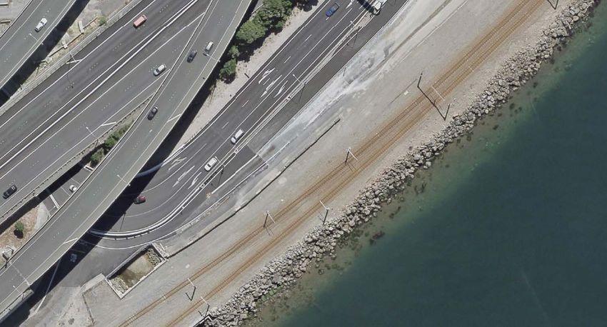
Quality Assurance
   Prepared by
Rob Greenaway & Associates (R&R Consultancy (NZ) Ltd)

   Revision History:

 Revision          Author            Approved for Issue
                                     Name        Signature                                         Date

                   Rob               Rob
 Final                                                                                             19 September 2020
                   Greenaway         Greenaway

   Quality Information
Document Title: Te Ara Tupua - The Ngā Ūranga To Pito-One Path - Recreation Review: Effects
Assessment and Future Recreation Values

Version: Final

Date: 19 September 2020

Prepared by: Rob Greenaway

Reviewed by: Susan Rawles and Simon Kennett (Waka Kotahi), Max Pocock (Beca) and Buddle
Findlay.

   Disclaimer
This report (‘Report’) has been prepared by Rob Greenaway & Associates (R&R Consulting (NZ) Ltd) exclusively for Waka
Kotahi NZ Transport Agency (‘Client’) in relation to the Ngā Ūranga to Pito-One project. R&R Consulting (NZ) Ltd accepts
no liability whatsoever for any reliance on or use of this Report, in whole or in part, for any use or purpose other than the
purpose for which it was prepared or any use or reliance by any third party.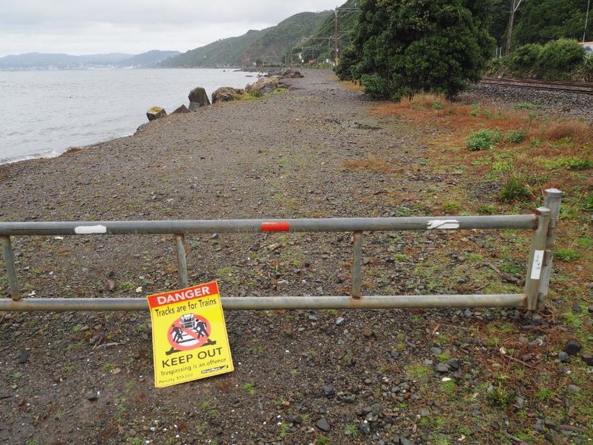
Executive summary
The Ngā Ūranga ki Pito-One Shared Path Project (the Project) is part of the Te Ara Tupua
Programme which aims to deliver a shared path between Melling and the Wellington CBD. This
Project involves construction of a shared path from the Ngā Ūranga interchange to just south of the
Pito-One Railway Station. The shared path will cater for active modes of transport including walking
and cycling, and will provide an alternative for commuters to the deficient State Highway 2 (SH2)
cycle path located adjacent to the southbound SH2 carriageway. The primary purpose is not to
establish a recreation setting between Ngā Ūranga and Pito-One, or to prioritise recreation. However,
recreational benefits will accrue nonetheless, and the Project design aims to maximise dual use
within its unavoidable constraints. This assessment considers how the Project maximises benefits to
commuters, how recreational value can also be gained as a secondary outcome, and how adverse
effects on existing recreation opportunities can be managed.
This report is presented in two parts. The first assesses the effects of the Project on existing
recreation opportunities. The second reviews the recreation benefits of the Project.
This report has been prepared in parallel with several other complementary assessments, particularly
the Technical Report 1: Strategic Transport Assessment, Technical Report 2: Shared Path Demand
Assessment and Design Review, and Technical Report 3: Integrated Transport Assessment.
Effects on existing recreation
The study area is divided into three sections:
Sector 1. Ngā Ūranga Interchange and Bridge Crossing.
Sector 2. Ngā Ūranga to Honiana Te Puni Reserve - Path and Ūranga.
Sector 3. Honiana Te Puni Reserve and the Pito-One to Melling (P2M) Connection.
Sectors 1 and 2 have limited existing recreation value due to a lack of public access to the coast and
seaward of the railway, and the poor state of the existing cycle path on SH2. The existing cycle path
will not be closed as part of the Project. Effects in these sectors relate to encroachment into the
coastal marine environment (CMA) with the potential to affect inshore fishing, snorkelling and boating
activities. For the latter, this includes rowing, waka ama, kayaking and other small boat activity.
However, due to inshore hazards, none of these activities normally occur sufficiently close to the
shore to be affected by the Project and there will be no change to the scale of local boating
opportunity. The new shared path will provide more opportunity to view and administer small boat
races (rowing, waka ama and other paddling sports) which typically begin at Honiana Te Puni
Reserve (the Reserve) and follow the coast south adjacent to the proposed shared path. Fishing and
snorkelling are currently infrequent uses of the setting due to poor access and the availability of
superior alternatives. The marine component of the ecology assessment indicates the retention of
most of the rocky habitat preferred by fish species and the development of new habitat to address
losses. Enhanced access will benefit both activities.
Effects in Sector 3 result mainly from the temporary occupation of 34% percent of Honiana Te Puni
Reserve for the Northern Construction Yard (and just over 7.5% of all public land owned by either
Taranaki Whānui ki te Upoko o te Ika (Taranaki Whānui) or Hutt City Council along the Pito-One
foreshore, not including beach areas). Access along the foreshore adjacent to the Northern
Construction Yard will remain in place, but there will be no public access to the existing boat
launching site across the beach adjacent to the existing Wellington Water Ski Club clubroom, and
limited access for club events. This clubroom and the nearby Wellington Rowing Association building
are within the proposed Northern Construction Yard and are proposed to be permanently replaced,
Te Ara Tupua | The Ngā Ūranga to Pito-One Path | Recreation Review 3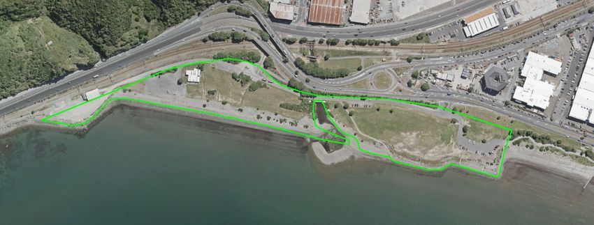
prior to construction beginning, with a new integrated clubs building in the eastern corner of Honiana
Te Puni Reserve.
Remaining temporary effects include the loss of access to the existing public beach ramp for the
three-year construction period. Small craft, such as kayaks and rowing skiffs, will be able to be
launched immediately east of the Reserve and adjacent to the new integrated clubs building. This
beach site is, however, unsuitable for launching large powered craft such as waterski boats, and for
the construction period these will need to be launched from existing concrete ramps at Sladden Park,
Seaview or Lowry Bay (most likely Seaview). The existing beach ramp at Honiana Te Puni Reserve
is unsuitable for 2WD cars with boat trailers (the water ski club currently relies on a tractor) and the
temporary effects on public boat launching will be minor and mostly related to small ‘tinnies’
(aluminium dinghies with small outboards) fishing locally, and jet skis. There is adequate capacity at
alternative boat ramps to cope with any displaced boat launching activity.
Construction activity will also result in temporary occupation of a small portion of the Pito-One
foreshore (7.5%), including a popular dog walking area (a temporary loss of access to 7% of the dog
exercise space on the Pito-One foreshore and 13% of space west of the Pito-One wharf). There is
adequate capacity along the foreshore for displaced activities.
Post-construction, Waka Kotahi NZ Transport Agency (Waka Kotahi) has committed to rehabilitating
the Reserve. Final details in terms of the layout of the Reserve will be confirmed through active
engagement between Hutt City Council, Taranaki Whānui, and Waka Kotahi, during the construction
period. A visioning exercise with these parties has established the likely main components of the
rehabilitated Reserve. Boat launching access to the existing beach ramp will be defined by future
reserve management planning exercises beyond the scope of this Project, but is anticipated to
include, at least, continued access for the existing watersports clubs. However, the ultimate design,
development and maintenance of Honiana Te Puni Reserve is controlled by Taranaki Whānui and
the Hutt City Council in accordance with Treaty of Waitangi Settlement Legislation and the Reserves
Act 1977, and cannot (and should not) be defined by consent conditions associated with the Project,
beyond those which form part of the application.
The assessment indicates that the Project, and its construction process, is fully supportive of the
objectives of the NZCPS, RCP and PNRP, and the City of Lower Hutt and Wellington City District
Plans, as they relate to recreation and coastal access objectives – considering both the scale of
temporary effects during construction, the benefits of improved coastal access provided by Te Ara
Tupua, and the rehabilitation of Honiana Te Puni Reserve as agreed with Taranaki Whānui and the
Hutt City Council.
Future recreation value
The second part of this report:
Reviews the plans, strategies and motivations of the three relevant councils and the Great
Harbour Way Trust for developing recreation and active transport networks in the Project
area. This indicates the strategic nature of the Project and the expectation that it will
contribute to a regional network of recreation and tourism access opportunities. It is
important to recognise the ongoing commitment by these agencies – and the advocacy
groups represented in the consultation for this and preceding scoping reports for the
Project – in creating a comprehensive trails complex in the Wellington Region, and the
degree to which Te Ara Tupua represents a critical link.
Provides a review of international and domestic literature which quantifies and provides
context for the benefits of physical activity, and active transport in particular. There is
strong international agreement that physical activity is fundamental to physical and mental
wellbeing, and that there are significant economic gains to be made from physical activity
Te Ara Tupua | The Ngā Ūranga to Pito-One Path | Recreation Review 4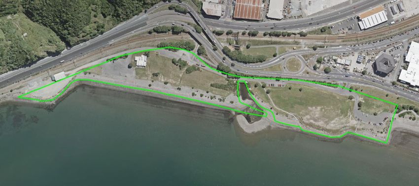
uptake. There are numerous examples of where the cost and benefits of active transport
developments have been quantified and shown to be substantially positive.
Considers the degree to which recreation and tourism activity on the shared path will
complement the demand assessment in Technical Report 2, and concludes that this
assessment is likely to be conservative in its assessment of the likely use of the shared
path, noting that the scale of tourism update is difficult to predict, and similarly the scale of
benefit from tourism considering the shared path’s connection to an existing national cycle
trail. However, the ability to further develop the Great Harbour Way, and to create an
attraction in its own right, will open new tourism product for the Wellington region.
The Project will result in significant increases in recreation participation in the study area, and the
net outcome for recreation in general terms will be manifestly positive. Benefits from physical activity
uptake have been widely endorsed by substantial international research, and quantified at an
economic level. A lack of physical activity has been shown to be third to smoking and diet as
modifiable risk factors in poor health, accounting for 9.5% of all deaths per year in New Zealand in
the early 2010s. Physical activity helps protect against heart disease, stroke, type two diabetes,
certain cancers, osteoporosis and depression. It is also important for maintaining a healthy weight
and preventing and reducing obesity. Walking, cycling and running are some of the most important
forms of physical activity in New Zealand.
Built environments designed to allow and encourage physical activity have been shown to
substantially increase activity levels. Without a safe and attractive setting for recreation, the benefits
of physical activity uptake are unlikely to accrue, and their wide availability is an important equity
issue.
This assessment also finds that the uptake projections used in the Technical Report 2 are likely to
be conservative considering potential additional activity on the path from weekday recreational
cycling and domestic and international tourism. For the health benefits value assessment described
in Technical Report 1, medium per-kilometre figures for the benefits of active transport modes for
cycling and walking were used. These are 2008 figures and so present a conservative basis for a
2020 calculation.
Te Ara Tupua | The Ngā Ūranga to Pito-One Path | Recreation Review 5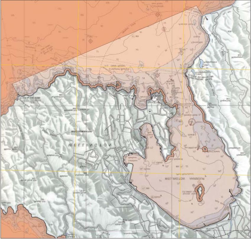
Contents

Executive summary .......................................................................................................................... 3
     Effects on existing recreation .......................................................................................................... 3
     Future recreation value ................................................................................................................... 4

1.      Introduction .............................................................................................................................. 10
     1.1.      Project Description ............................................................................................................. 11
     1.2. Author details ...................................................................................................................... 13
       1.2.1. Code of Conduct ......................................................................................................... 13

2.      Study area and scope.............................................................................................................. 15
     2.1.      Assessment methodology .................................................................................................. 16

3.      Statutory and planning framework ........................................................................................ 17
     3.1. Statutory documents........................................................................................................... 17
       3.1.1. NZ Coastal Policy Statement 2010 ............................................................................. 17
       3.1.2. Conservation Management Strategy .......................................................................... 18
       3.1.3. Greater Wellington Regional Council .......................................................................... 18
       3.1.4. Wellington City Council ............................................................................................... 21
       3.1.5. Hutt City Council.......................................................................................................... 22

4.      Description of existing environment ..................................................................................... 24
     4.1. Sector 1: Connection with the Ngā Ūranga interchange and the bridge crossing the Hutt
     Valley Railway line ........................................................................................................................ 24
     4.2. Sector 2: Path, reclamation and structures between Ngā Ūranga and Honiana Te Puni
     Reserve ......................................................................................................................................... 25
     4.3. Sector 3: Path works adjacent to Honiana Te Puni Reserve and connections to P2M and
     Pito-One Esplanade ...................................................................................................................... 28
       4.3.1.  Honiana Te Puni Reserve status ................................................................................ 28
       4.3.2.  Reserve uses .............................................................................................................. 30

5.      Assessment of effects............................................................................................................. 38
     5.1. Effects of the proposal on Honiana Te Puni Reserve ........................................................ 40
       5.1.1. Conclusion - Honiana Te Puni Reserve ...................................................................... 42
     5.2. Coastal setting adjacent the Project alignment (sectors 1 – 3) .......................................... 43
       5.2.1. Conclusion – Coastal setting....................................................................................... 43

6.      Scope of values review ........................................................................................................... 45

7.      Plans and strategies ................................................................................................................ 46
        7.1.1.        Great Harbour Way/Te Aranui o Pōneke .................................................................... 46
        7.1.2.        Wellington City Council ............................................................................................... 47
        7.1.3.        Hutt City Council.......................................................................................................... 51
        7.1.4.        Wellington Regional Trails for the Future .................................................................... 52
     7.2.      Summary ............................................................................................................................ 53

8.      Benefits review ........................................................................................................................ 54
     8.1.      Benefits of physical activity ................................................................................................ 54
     8.2.      Negative effects of activity .................................................................................................. 58

Te Ara Tupua         | The Ngā Ūranga to Pito-One Path               |   Recreation Review                                                             6
8.3.      Activity Friendly Environments and physical activity .......................................................... 59
     8.4.      Regional recreation and tourism ........................................................................................ 60
     8.5.      Projected uptake and economic benefits of Te Ara Tupua ................................................ 62
     8.6.      Summary ............................................................................................................................ 63

9.      Summary and conclusion ....................................................................................................... 64
     9.1.      Effects on existing recreation activities .............................................................................. 64
     9.2.      Recreation and related benefits of Te Ara Tupua .............................................................. 65

10.         References ............................................................................................................................ 66

Appendix 1: User Group Workshop Summary ............................................................................ 69

Appendix 2: Telephone Interview Summary ................................................................................ 73

Appendix 3: Pito-One Beach West dog exercise area ................................................................ 80

Appendix 4: Regional and local recreation participation summary .......................................... 81
     General recreation participation levels .......................................................................................... 81
     Marine recreation activity distribution ............................................................................................ 83
      Shellfish gathering and swimming ............................................................................................. 83
      Fishing and diving ...................................................................................................................... 85
      Boating and sailing .................................................................................................................... 87
      Surfing........................................................................................................................................ 88

Te Ara Tupua         | The Ngā Ūranga to Pito-One Path              |   Recreation Review                                                             7
FIGURES
Figure 1: Project sectors ................................................................................................................................... 12
Figure 2: Wellington City District Plan Map 22 detail, Ngā Ūranga intersection and north................................ 21
Figure 3: Hutt District Plan Special Recreation Activity Area 1 – Pito-One Foreshore (teal)............................. 23
Figure 4: Ngā Ūranga ....................................................................................................................................... 24
Figure 5: Barrier arm at the southern end of Honiana Te Puni Reserve ........................................................... 25
Figure 6: SH2 cycleway wire rope barrier section, Horokiwi. Google Earth image, May 2019 .......................... 26
Figure 7: SH2 cycleway on-road section 500m south of The Esplanade. Google Earth, May 2019 ................. 26
Figure 8: SH2 cycleway on-road section 300m south of The Esplanade. Laura Skilton, Nov 2019.................. 26
Figure 9: Survey result for State Highway 2 cycling use, the Transport Agency (2012b) ................................. 27
Figure 10: Honiana Te Puni Reserve (LINZ 2016/17 aerial) ............................................................................. 29
Figure 11: Land status at Honiana Te Puni Reserve ........................................................................................ 29
Figure 12: Honiana Te Puni Reserve features .................................................................................................. 30
Figure 13: Rowing event at Honiana Te Puni. Google Earth image, December 2002 ...................................... 31
Figure 15: Waterski and Personal Water Craft (PWC) lanes, Wellington Harbour............................................ 32
Figure 14: GWRC water skier access lane, Pito-One Beach (west) ................................................................. 32
Figure 16: Boat launching ramps, Wellington Harbour ..................................................................................... 33
Figure 17: Strava heatmap for water sports 24 months to August 2019, northern half of harbour .................... 34
Figure 18: Strava heatmap for watersports 24 months to August 2019, northern detail ................................... 35
Figure 19: Strava heatmap for watersports 24 months to August 2019, western detail .................................... 35
Figure 20: Hutt City Council dog exercise areas near Pito-One........................................................................ 36
Figure 22: Strava heatmap for cycling 24 months to March 2020 ..................................................................... 37
Figure 21: Strava heatmap for running 24 months to March 2020 .................................................................... 37
Figure 23: Proposed Northern Construction yard and Integrated Clubs Building location ................................ 39
Figure 24: Great Harbour Way, Boffa Miskell 2009 .......................................................................................... 47
Figure 25: Wellington City Cycleway Network Plan detail (Cycling Framework 2015) ...................................... 49
Figure 26: Key Routes Map, Walk and Cycle the Hutt 2014-2019 .................................................................... 51
Figure 27: Remutaka Cycle Trail (nzcycletrail.com).......................................................................................... 53
Figure 28: Factors which would influence increase in cycling uptake (Transport Agency 2012b)..................... 54
Figure 29: New Plymouth Coastal Walkway benefits analysis (Groundwater 2016) ......................................... 58
Figure 30: Sport and recreation activities with the highest participation levels for Wellington .......................... 81
Figure 31: Participation locations in natural settings, Wellington (Sport NZ 2015)............................................ 82
Figure 32: GWRC Regional Coastal Plan Coastal Water Classes for Wellington Harbour ............................... 83
Figure 33: GWRC monitored marine bathing sites in and around Wellington Harbour ..................................... 84
Figure 34: SLNZ recommended swimming beaches ........................................................................................ 85
Figure 35: Surfcasting guide recommendation, Draper & Airey (2012)............................................................. 86
Figure 36: Windsurf launch sites....................................................................................................................... 87
Figure 37: Korokoro rowing courses ................................................................................................................. 87
Figure 38: Motorway Classic short course. White lines indicate rock hazards. Welly Paddlers map ................ 88
Figure 39: Motorway Classic long course. Welly Paddlers map ....................................................................... 88

TABLES
Table 1: Per-kilometre benefits of active transport modes (Genter et al 2008) ................................................. 57
Table 2: Summary of construction effects by sector ......................................................................................... 64

Te Ara Tupua         | The Ngā Ūranga to Pito-One Path                 |   Recreation Review                                                                  8
GLOSSARY OF ABBREVIATIONS AND DEFINED TERMS

 Active modes of                Forms of active mobility including walking, running, cycling and micro
 transport                      mobility which may be utilised along the path

 AEE                            Assessment of Effects on the Environment

 CBD                            Central business district

 CMA                            Coastal marine area

 CMS                            Conservation management strategy

 DOC                            Department of Conservation

 DTMR                           State of Queensland’s Department of Transport and Main Roads

 GHW                            Great Harbour Way - Te Aranui o Poneke

 GPS                            Global positioning system

 GWRC                           Greater Wellington Regional Council

 HCC                            Hutt City Council

 LINZ                           Land Information New Zealand

 MfE                            Ministry for the Environment

 MHWS                           Mean High Water Springs

 MoH                            Ministry of Health

 NZCPS                          New Zealand Coastal Policy Statement 2010

 P2M                            Pito-One to Melling section of Wellington to Hutt Valley

 PNRP                           Proposed Natural Resources Plan

 RCP                            Operative Regional Coastal Plan for the Wellington Region

 RMA                            Resource Management Act 1991

 RPS                            Regional Policy Statement

 SH2                            State Highway 2

 Strava                         A recreation and exercise activity tracking social media application

 SUP                            Stand up paddleboard

 Waka Kotahi                    Waka Kotahi NZ Transport Agency

 WCC                            Wellington City Council

Te Ara Tupua   | The Ngā Ūranga to Pito-One Path   |   Recreation Review                                 9
1. Introduction
This report:
Assesses the effects of the Project on existing recreation opportunities; and
Reviews the recreation benefits of the Project considering likely future use patterns.
Accordingly, this report has three separate sections:
This section – the introduction – which describes the Project;
Part one, which assesses the effects of the Project on existing recreation opportunities;
and
Part two, which reviews the recreation benefits of the Project.
This report needs to be read in parallel with three other technical assessments:
Technical Report 1. This quantifies the economic benefits of the Project, including those
from safety improvements for walking and cycling users of SH2 and the health benefits
from cycling and walking uptake on the new shared path;
Technical Report 2. This report provides a forecast of user uptake and reviews the
performance and suitability of the proposed shared path width and other design features;
and
Technical Report 3. This considers effects of construction and operation of the Project on
parking, and walking, vehicle and cycle movements near and through Honiana Te Puni
Reserve and at Ngā Ūranga.
It is important to note that the purpose of the Project is to create an alternative transport opportunity
between Pito-One and Wellington primarily for commuters, and not to simply establish a recreation
setting, or to prioritise recreation. Therefore, the design of the Project focuses on facilitating the
alternative transport modes which best serve commuters (those travelling for work or for other regular
activities), while managing adverse effects on existing recreation opportunities. Recreational use is
secondary to the focus on commuting, but has been considered, and via a number of methods,
actively facilitated in the Project design.
This focus on commuting may limit the full recreational potential of the shared path, but recreational
benefits will accrue nonetheless, and the Project design aims to maximise dual use within its
unavoidable constraints. The critical issue here is that the benefits of the proposal should not be
measured against how it can maximise recreational benefits, but how it can maximise benefits to
commuters (or more broadly those using the shared path as a transport link); and how recreational
value can also be gained as a secondary outcome, and how adverse effects on existing recreation
opportunities can be managed.
This report has been prepared in support of the notices of requirement and applications for resource
consent for the Project made by Waka Kotahi under the COVID-19 Recovery (Fast-track Consenting)
Act 2020 (COVID-19 Recover Act). In particular, this report supports the assessment of the Project’s
effects on the environment as required by the COVID-19 Recovery Act. The requirements of the
Covid-19 Recovery Act and an overall assessment of the effects of the Project on the environment
are set out in the Assessment of Effects on the Environment.
Te Ara Tupua | The Ngā Ūranga to Pito-One Path | Recreation Review 101.1. Project Description
The Ngā Ūranga ki Pito-One 1 Shared Path Project (the Project) is part of the Te Ara Tupua
Programme, which aims to deliver a shared path between Pito-One and Wellington CBD. This Project
involves construction of a shared path from the Ngā Ūranga Interchange to just south of the Pito-
One Railway Station and associated works as shown in Figure 1.
The Project will cater for active transport modes including cycling and walking, and will provide an
alternative to the existing SH2 cycle path (existing cycle path) located between the Hutt Valley
Railway Line and the southbound SH2 carriageway. Works at Honiana Te Puni Reserve provide for
the removal and replacement of the existing Wellington Rowing Association and Wellington Water
Ski Club facilities at, and adjacent to, Honiana Te Puni Reserve and the introduction of new cultural
facilities into the Reserve.
The primary objective of the Project is to provide safe walking and cycling infrastructure between
Wellington and the Hutt Valley which will act as a catalyst for increased use of active transport modes.
The Project will also provide increased transport resilience, improve connections and integration with
planned and existing walking and cycling infrastructure in Wellington City and Hutt City and reconnect
people with this long-inaccessible part of the harbour’s edge.
The Project will provide a 4.5km-long shared path between Ngā Ūranga and Pito-One featuring the
following key elements:
a. A rail overbridge (shared path bridge) across the Hutt Valley Railway Line, connecting the
shared path from Ngā Ūranga to the coastal edge;
b. A path with a 5m surface width, on existing and newly created land and coastal structures,
on the seaward side of the Hutt Valley Railway Line;
c. A varied coastal edge which incorporates ūranga (landings), a rocky revetment the
intermittent use of strategically placed seawalls along the path edge. The coastal edge
treatment provides resilience, reflects the natural landscape, avoids sensitive habitat areas,
provides for cultural expression and enhances amenity;
d. Construction of new offshore habitat for coastal avifauna;
e. Connections to the Pito-One to Melling (P2M) path and the Pito-One Esplanade;
f. Construction of a new integrated clubs building at the eastern end of Honiana Te Puni
Reserve and an associated car parking area; and
g. A two-stage development of new cultural facilities at Honiana Te Puni Reserve, including:
i) Construction of temporary Tāwharau Pods, consisting of three small building pods
designed to accommodate a range of cultural or community uses, at the eastern end of
Honiana Te Puni Reserve; and
ii) Post construction, the construction of the Whare to the west of Korokoro Stream, and
permanent relocation of the Tāwharau pods to a site adjacent to the Whare at the
western end of Honiana Te Puni Reserve 2.
For description and assessment purposes in this report, the Project has been divided into three
sectors (as shown in Figure 1). These are:
1
This report uses the preferred Te Reo spelling of “Ngā Ūranga” and “Pito-One” even where the official name may instead
use “Ngauranga” or “Petone”.
2
The construction of the Whare and Tāwharau Pods is at Taranaki Whānui’s discretion
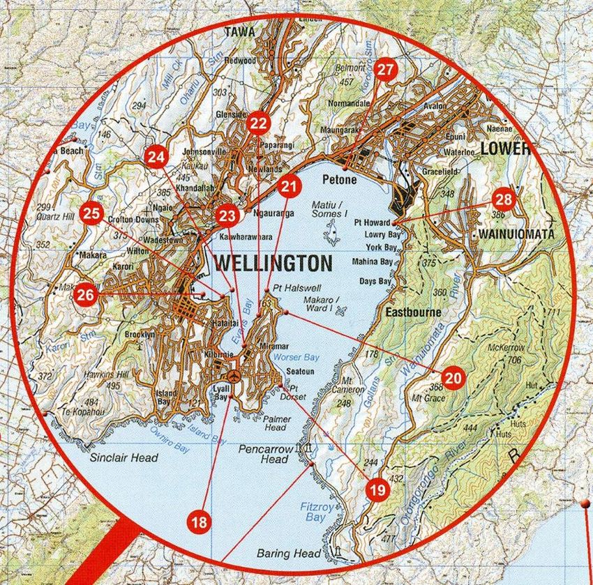
Te Ara Tupua | The Ngā Ūranga to Pito-One Path | Recreation Review 11Sector 1 Ngā Ūranga Interchange and Bridge Crossing:
The Southern Construction Yard and the connection from the Ngā Ūranga Interchange
via the shared path bridge across the Hutt Valley Railway Line, to the coastal edge.
Sector 2 Ngā Ūranga to Honiana Te Puni Reserve - Path and Ūranga:
The typical shared path, rock revetment, ūranga, seawall structures and off shore
habitats between Ngā Ūranga and Honiana Te Puni reserve; and
Sector 3 Honiana Te Puni Reserve and Pito-One to Melling (P2M) Connection:
Shared path connection to P2M adjacent to Honiana Te Puni Reserve, connections to
Honiana Te Puni Reserve and Pito-One Esplanade, the Northern Construction Yard,
integrated clubs building, associated car parking, the temporary and permanent
Tāwharau Pods and the Whare.
A full description of the Project including design and operation is provided in Chapter 3 Description
of the Project in the Assessment of Effects on the Environment.
A description of the potential construction methodology that could be used to construct the Project is
provided in Chapter 4 Construction of the Project of the Assessment of Effects on the Environment.
Rob Greenaway & Associates has been engaged to undertake an assessment of effects on
recreation and tourism associated with the proposed N2P project, and review the benefits of the
proposal for recreation, and the suitability of the path for those uses.
Figure 1: Project sectors
Te Ara Tupua | The Ngā Ūranga to Pito-One Path | Recreation Review 121.2. Author details My full name is Robert James Greenaway. I am a Director of Rob Greenaway & Associates (R&R Consulting (NZ) Ltd) and have been since 1997. Prior to this, I was a Recreation and Tourism Consultant for Boffa Miskell Limited in Christchurch, from 1995 until 1997, and before that I held the same position at Tourism Resource Consultants in Wellington, from 1990 until 1995. I hold a Diploma in Parks and Recreation Management (with Distinction) obtained from Lincoln University in 1987. I have comprehensive experience in undertaking recreation planning and management assessments and have completed more than 400 consultancy projects nationally. I have presented evidence at approximately 100 hearings, many for marine and coastal developments; including several marina proposals (Waikawa, Lyttelton, Bayswater, Waiheke Island), port dredging and development (Lyttleton, Whangarei), marine mining (Taranaki), the wreck of the Rena, marine farming (King Salmon, Port Gore, Kaipara Harbour, Port Levy, Firth of Thames and Mercury Bay, and marine discharges (Waimate, Nelson, Christchurch, Porirua, Wellington, Taranaki). I have worked on many other marine recreation assessments throughout New Zealand for water supply and treatment infrastructure, transport projects, reclamations and recreation developments. I have completed many projects in the Wellington region including the Eastern Bays shared path proposal for Hutt City, user surveys of the Hutt River corridor for the Greater Wellington Regional Council, a masterplan for Mount Victoria (with Megan Wraight), the Wellington airport runway extension proposal, Seaview wastewater outfall and cross-harbour water pipeline reviews for Wellington Water, and CentrePort’s harbour deepening proposal, amongst other things. I am an accredited Recreation Professional with Recreation Aotearoa (the New Zealand Recreation Association). I am also a past executive member of the National Executive of Recreation Aotearoa, and I am ex-Chair and current member of the Recreation Aotearoa Board of Accreditation. I was awarded the Ian Galloway Memorial Cup in 2004 by Recreation Aotearoa to recognise “excellence and outstanding personal contribution to the wider parks industry”. In 2013 I was awarded the position of Fellow of Recreation Aotearoa. I am an experienced coastal sailor and own a 10m keeler based in the Nelson Marina, which in early 2019 I sailed solo around the North Island. I am a PADI certified scuba diver (since 1983), although my last dive was on the wreck of the Rena in 2016. I have sea kayaking experience and once owned a double sea-kayak. I was born while my parents were living aboard a yacht built by my father and have substantial coastal and some blue-water sailing and boating experience. I am deputy chair of the Nelson Marina Advisory Group to the Nelson City Council, assisting with development and management direction for the Nelson Marina and its hardstand, boat ramp and watersports facilities. 1.2.1. Code of Conduct I have read the Code of Conduct for Expert Witnesses outlined in the Environment Court's Practice Note (2014) (Code) and have complied with it in preparing this assessment. I also agree to follow the Code when presenting to the Environment Planning Authority. I confirm that the issues addressed in this assessment are within my area of expertise, except where I state that I rely upon the assessments of other experts. I also confirm that I have not omitted to consider material facts known to me that might alter or detract from my opinions. Te Ara Tupua | The Ngā Ūranga to Pito-One Path | Recreation Review 13
PART ONE: EFFECTS ASSESSMENT
An assessment of the effects of the Project on existing recreation in the study area.

Te Ara Tupua   | The Ngā Ūranga to Pito-One Path   |   Recreation Review                14
2. Study area and scope
The study area for this effects assessment is focused on the proposed shared path extending from
the Ngā Ūranga Interchange in the south to near the Petone Railway Station in the north. The
terrestrial part of the development area – seaward of the railway corridor – is closed to public access
and there are no direct effects on existing recreation there. However, Honiana Te Puni Reserve on
the Pito-One foreshore is proposed to be partly occupied as a laydown area for the construction
period (up to three years), and the study area also includes the coastal and marine area adjacent to
the proposed reclamation, which has some marine recreation values which are largely based out of
Honiana Te Puni Reserve.
The study area for the effects assessment does not include SH2 and the cycleway there, where no
construction work is proposed. I understand that closing the existing cycle path is not part of this
Project, and if it remains in place then some limited use of it may remain post-construction, although
it meets no standard for a recreation route. This assessment also does not consider adverse effects
on recreation between the Pito-One foreshore and Melling Station, as the Project is merely an
upgrade of the level of service for existing recreation activities and can only be considered in terms
of benefits for users. Standard traffic management procedures will be followed during the
construction period.
The scope for the effects assessment includes all existing recreation activities which may be affected
by the construction of and operation of the Project. This includes tourism, which is a subset of
recreation. Tourists often do the same recreation activities as locals, but can be differentiated by their
motivations, access to information, benefits and costs they accrue to their host locale, and the fact
that they are staying at least one night away from home. However, there are no adverse effects on
tourism from the construction of the Project, and only benefits from its operation.
The objectives of this effects assessment are to:
Review the statutory framework which an assessment of effects must advise;
Describe the physical setting where the proposal is to be located (the existing environment)
and review the recreation uses of that setting; and
Review the potential adverse effects of the construction and operation of the shared path
on existing recreation activities, and recommend any necessary mitigations.
The Project will result in significant increases in recreation participation in the study area, and the
net outcome for recreation in general terms will be manifestly positive. These benefits are considered
in Part two of this report. The focus here is to consider existing recreation uses of the study area and
how to ensure they are able to continue, as much as possible, during and after construction.
Te Ara Tupua | The Ngā Ūranga to Pito-One Path | Recreation Review 152.1. Assessment methodology
This assessment is based on:
Site visits;
Literature review and review of public and targeted project consultation records from 2012;
Review of assessment matters required by relevant local and regional plans;
Liaison with relevant project specialists;
A workshop with user group representatives (see Appendix 1); and
Telephone interviews with representatives of the following agencies (or individuals) to
identify their use of the coastal setting in the north-west corner of Wellington Harbour as
well as the potential effects of the proposed coastal reclamation (a full summary of findings
is provided in Appendix 2):
- Greater Wellington Regional Council, Hutt River Ranger
- Petone Community Board
- Lowry Bay Yacht Club
- Seaview Marina
- St James Sea Scout Group
- Wellington Recreational Marine Fishers Association (Jim Mikoz)
- Wellington Yakity Yak Sea Club
- Wellington Ocean Sports
- Hikoikoi Waka Club
- Hutt River Trail - Rotary coordinator
- Local spear fisher (Derek Wilshere)
- Windsurfer, paddle board, kite surfer (Bruce Spedding)
- Harbour Master
- TS Tamatoa Navy Cadets
- Heretaunga Boating Club
- Canoe and kayak retailer
- Dive HQ (retailer)
Te Ara Tupua | The Ngā Ūranga to Pito-One Path | Recreation Review 163. Statutory and planning framework
This section reviews the statutory documents which help define the assessment matters against
which positive and adverse effects of the proposal must be measured.
Further analysis of strategic planning relating to the national and roading network is provided in
Technical Report 1.
Various consultation processes carried out since 2014 have led to the preferred option of the shared
path to be constructed on the seaward side of the Wairarapa railway line. Several traffic and scheme
option studies also preceded these more recent reports. This early project planning work is not
repeated in this report.
3.1. Statutory documents
3.1.1. NZ Coastal Policy Statement 2010
The New Zealand Coastal Policy Statement 2010 (NZCPS, DOC 2010) guides local authorities in
their day-to-day management of the coastal environment. Objective 4 of the NZCPS refers to
maintaining and enhancing the public open space qualities and recreation opportunities of the coastal
environment by:
Recognising that the coastal marine area is an extensive area of public space for the public
to use and enjoy;
Maintaining and enhancing public walking access to and along the coastal marine area
without charge, and where there are exceptional reasons that mean this is not practicable
providing alternative linking access close to the coastal marine area; and
Recognising the potential for coastal processes, including those likely to be affected by
climate change, to restrict access to the coastal environment and the need to ensure that
public access is maintained even when the coastal marine area advances inland.
The coastal marine area is defined by the Resource Management Act 1991 (Section 2) as the
foreshore, seabed, coastal water and air space above the water between Mean High Water Springs
(MHWS) and 12 nautical miles offshore, and is considered to include all areas affected by the Project.
Policy 6 of the NZCPS refers to ‘Activities in the coastal environment’ and the need to “recognise the
need to maintain and enhance the public open space and recreation qualities and values of the
coastal marine area.” (6 (2) (b)).
Policy 16 refers to the need to protect surf breaks of national significance. None are identified in the
Wellington Region.
Policy 18 refers to public open space:
Recognise the need for public open space within and adjacent to the coastal marine area,
for public use and appreciation including active and passive recreation, and provide for
such public open space, including by:
a) ensuring that the location and treatment of public open space is compatible with
the natural character, natural features and landscapes, and amenity values of the
coastal environment;
b) taking account of future need for public open space within and adjacent to the
coastal marine area, including in and close to cities, towns and other settlements;
c) maintaining and enhancing walking access linkages between public open space
areas in the coastal environment;
Te Ara Tupua | The Ngā Ūranga to Pito-One Path | Recreation Review 17d) considering the likely impact of coastal processes and climate change so as not
to compromise the ability of future generations to have access to public open
space; and
e) recognising the important role that esplanade reserves and strips can have in
contributing to meeting public open space needs.
Policy 19 refers to walking access, including:
1. Recognise the public expectation of and need for walking access to and along the
coast that is practical, free of charge and safe for pedestrian use.
2. Maintain and enhance public walking access to, along and adjacent to the coastal
marine area, including by:
a) identifying how information on where the public have walking access will be made
publicly available;
b) avoiding, remedying or mitigating any loss of public walking access resulting from
subdivision, use, or development; and
c) identifying opportunities to enhance or restore public walking access, for example
where:
i. connections between existing public areas can be provided; or
ii. improving access would promote outdoor recreation; or
iii. physical access for people with disabilities is desirable; or
iv. the long-term availability of public access is threatened by erosion or sea
level rise; or
v. access to areas or sites of historic or cultural significance is important; or
vi. subdivision, use, or development of land adjacent to the coastal marine
area has reduced public access, or has the potential to do so.
There is high congruence between the NZCPS and the proposal, considering its ability to deliver safe
and practical public access in a coastal setting suited to a wide range of abilities, connecting many
open space settings, both coastal and inland.
3.1.2. Conservation Management Strategy
There are no coastal reserve areas in Wellington Harbour in the study area identified in the operative
Department of Conservation’s Wellington Conservation Management Strategy (CMS) 2019 (DOC
2019) and there is no specific reference to the study area. The CMS is also generally silent about
recreation values and issues in the Harbour, noting (p44, Vol 1):
The Wellington coast is an important part of this region’s identity, whether it is as a source of
kaimoana, a day spent fishing or exploring the rock pools, diving the many shipwrecks that are
found in the area, sailing in Wellington Harbour or just taking a leisurely walk along the beach
or waterfront. There are a number of internationally ranked surf breaks along the Wairarapa
coast, and it also provides a highly prized recreational and commercial inshore fishery.
3.1.3. Greater Wellington Regional Council
Regional Policy Statement for the Wellington Region
The operative Regional Policy Statement for the Wellington Region (GWRC 2013) (RPS) identifies
that (p21) ‘the coastal environment is important to the regional community for recreation and general
enjoyment’ and aims to support the implementation of the NZCPS particularly with regard to the
maintenance and enhancement of public access to and along the coastal marine area (p22).
Te Ara Tupua | The Ngā Ūranga to Pito-One Path | Recreation Review 18Regionally significant issues for recreation for iwi identified in the RPS include the suitability of coastal
water for recreation and shellfish gathering (p23).
Recreation values are identified as being managed via, predominantly, providing for access to and
along the coastal marine area (Objective 8, p31). Amenity values, more generally, are considered
via policies to manage effects on natural character, coastal water quality and ecosystems, and
natural coastal processes (p23). While the RPS identifies rivers and lakes with ‘significant amenity
and recreational values’ (RPS Appendix 1), the same data are not provided for any coastal areas.
Regional Coastal Plan for the Wellington Region
The Regional Coastal Plan for the Wellington Region (WRC 2000) (RCP) identifies coastal areas to
be managed for shellfish gathering purposes and contact recreation. These are reviewed in Appendix
4 of this report.
The RCP notes that (section 2.4.4):
Disturbance of the foreshore or seabed may affect:
water turbidity and hence amenity values;
commercial and recreational fishing;
access along and within the coastal marine area;
other recreational use of the foreshore, seabed, and other related parts of the coastal
marine area.
Section 2.4.6 also notes the potential to liberate contaminants through seabed disturbance, which
could pollute shellfish beds, with associated risks to human health.
The RCP identifies (section 2.5) that the ‘deposition of substances on foreshore or seabed’ may
affect, amongst other things, recreational fisheries, fish spawning and nursery grounds, public health
through consumption of contaminated shellfish, wave energy, water circulation, sediment transport
and shoreline stability (and therefore amenity values) and marine navigation. Section 7.1 of the RCP
sets out objectives to manage these potential adverse effects.
The RCP seeks to ensure that as a general objective (4.1.9), the ‘Amenity values in the coastal
marine area are maintained and enhanced’.
Proposed Natural Resources Plan for the Wellington Region
The Proposed Natural Resources Plan for the Wellington Region (GWRC Decisions version, July
2019) (PNRP) identifies several relevant high-level objectives for the management of recreation
values in the region, including:
Objective O9
The recreational values of the coastal marine area, rivers and lakes and their margins
and natural wetlands are maintained and enhanced.
Objective O10
Public access to and along the coastal marine area and rivers and lakes is maintained
and enhanced.
….
Objective O24
Rivers, lakes, natural wetlands and coastal water are suitable for contact recreation and
Māori customary use, including by:
(a) maintaining water quality, or
Te Ara Tupua | The Ngā Ūranga to Pito-One Path | Recreation Review 19(b) improving water quality in:
….
(ii) coastal water and sites with significant mana whenua values and Ngā Taonga
Nui a Kiwa to meet, as a minimum, the primary contact recreation objectives in
Table 3.3 [which sets indicator bacteria levels and objectives for contact
recreation, Māori customary use and shellfish quality]…
Objective O55
The need for public open space in the coastal marine area is recognised.
‘Primary coastal policies’ for coastal management include the need to consider amenity values:
Policy P9: Public access to and along the coastal marine area and the beds of lakes
and rivers
Maintain and enhance the extent or quality of public access to and along the coastal
marine area and the beds of lakes and rivers except where it is necessary to:
….
(c) protect public health and safety, or
(d) provide for a temporary activity such as construction, a recreation or cultural event or
stock movement, and where the temporary restrictions shall be for no longer than
reasonably necessary before access is fully reinstated, …
Policy P10: Contact recreation and Māori customary use
Use and development shall avoid, remedy or mitigate any adverse effects on contact
recreation and Māori customary use in fresh and coastal water, including by:
….
(d) providing for the passive recreation and amenity values of fresh water bodies and the
coastal marine area.
Policy P133: Recreational values
The adverse effects of use and development in the coastal marine area on recreational
values shall be managed by providing for a diverse range of recreational opportunities
while avoiding conflicts and safety issues.
Policy P134: Public open space values and visual amenity
The adverse effects of new use and development on public open space and visual
amenity viewed within, to and from the coastal marine area shall be minimised by:
….
b) managing use and development to be of a scale, location, density and design which
is compatible with the natural character, natural features and landscapes and
amenity values of the coastal environment, and the functional needs, operational
requirements and locational constraints, [sic] the Commercial Port Area and the
Wellington International Airport; and
(c) taking account of the future need for public open space in the coastal marine area.
Te Ara Tupua | The Ngā Ūranga to Pito-One Path | Recreation Review 203.1.4. Wellington City Council
The rail corridor east of SH2 from Ngā Ūranga north to the Hutt City boundary is zoned Open Space
B (Natural Environment) in the Wellington City District Plan (2000, amended to 9 March 2010) (Figure
2):
16.3 Open Space B (Natural environment)
Open Space B land is valued for its natural character and informal open spaces. It involves
areas that are used for types of recreation that, in the broadest sense, do not involve buildings
or structures. The intention is to keep such areas in an unbuilt or natural state. This type of
open space encompasses both formal and informal open space elements. It includes
walkways, scenic areas and open grassed areas where buildings are inappropriate. Its
characteristics are minimal structures, largely undeveloped areas and open expanses of land.
Most Open Space B areas are vegetated and often have ecological values or may buffer
Conservation Sites.
Figure 2: Wellington City District Plan Map 22 detail, Ngā Ūranga intersection and north
This is the same zone as applies to the coastal cliffs immediately to the west of SH2.
The site is also designated for ‘Railway Purposes’ and is “Railway land pursuant to various
proclamations, gazettes, & statutory ownership” (R5, Schedule 3, Ch24).
The Plan does not have any objectives or policies specific to the site (unlike the Inner and Outer
Town Belt), but those generally applied to the Open Space zone are relevant:
16.5 Open Space Objectives and Policies
OBJECTIVE
16.5.1 To maintain, protect and enhance the open spaces of Wellington City.
POLICIES
To achieve this objective, Council will:
Te Ara Tupua | The Ngā Ūranga to Pito-One Path | Recreation Review 2116.5.1.1 Identify a range of open spaces and maintain their character, purpose and function,
while enhancing their accessibility and usability.
METHODS
….
Accessibility to the City’s open spaces is an important aspect of their management, to ensure
that everyone (including people with mobility restrictions) has equitable access to sportfields,
reserves and other open spaces. The City will promote enhanced accessibility through
advocacy and its operational activities. The environmental result will be the continued
protection of the open character of such land.
3.1.5. Hutt City Council
City of Lower Hutt District Plan
The Hutt City District Plan defines three ‘Special Recreation Activity Areas’ which are “of distinctive
character. These areas provide opportunities for recreation activities which are unavailable in other
parts of the City. This difference needs to be recognised and maintained.” Area 1 is the Pito-One
Foreshore (teal area in Figure 3) which includes Honiana Te Puni Reserve and extends south west
along the coastal railway corridor to the City boundary with Wellington.
‘Local Area Issues’ relating to the Foreshore include:
7B(i) 1.1.1 Retaining the Open Space Character
Issue
It is important that activities carried out retain the open space character of the area and are
compatible with the coastal marine area.
Objective
That activities carried out on the Petone Foreshore retain the open space character and are
compatible with the coastal environment.
Policy
(a) To allow a range of informal recreation activities.
Explanation and Reasons
In order to retain the open space character of the area and amenity values informal recreation
activities are considered to be appropriate.
‘Site Development Issues’ relating to the Foreshore include:
7B(i) 1.2.1 Buildings and Structures
Issue
While there are some existing buildings such as the Settlers Museum, boating and rowing club
buildings and the Oarsman Cabaret building, it is important that the number of buildings and
structures are restricted so that the open space character and amenity values of the area are
protected.
Objective
To conserve and protect the open space character and amenity values of the area.
Policy
(a) To discourage the development of buildings and structures which would reduce the amount
of land available to the public for informal recreation purposes.
(b) To ensure that the public have access to and along the coastal marine area.
Te Ara Tupua | The Ngā Ūranga to Pito-One Path | Recreation Review 22You can also read