Regional Association I - Tropical Cyclone Operational Plan for the South-West Indian Ocean - Tropical Cyclone Programme - WMO Library
←
→
Page content transcription
If your browser does not render page correctly, please read the page content below
Regional Association I –
                          Tropical Cyclone Operational Plan
                          for the South-West Indian Ocean

                          Tropical Cyclone Programme
                          Report No. TCP-12

                          2016 edition
WEATHER CLIMATE WATER

                        World
                        Meteorological
                        Organization

                        WMO-No. 1178
WMO-No. 1178

© World Meteorological Organization, 2016

The right of publication in print, electronic and any other form and in any language is
reserved by WMO. Short extracts from WMO publications may be reproduced without
authorization, provided that the complete source is clearly indicated. Editorial
correspondence and requests to publish, reproduce or translate this publication in part or in
whole should be addressed to:

Chairperson, Publications Board
World Meteorological Organization       (WMO)
7 bis, avenue de la Paix                 Tel.: +41 (0) 22 730 84 03
P.O. Box 2300                            Fax: +41 (0) 22 730 80 40
CH-1211 Geneva 2, Switzerland            E-mail: publications@wmo.int

ISBN 978-92-63-11178-4

NOTE

The designations employed in WMO publications and the presentation of material in this publication do
not imply the expression of any opinion whatsoever on the part of WMO concerning the legal status of
any country, territory, city or area, or of its authorities, or concerning the delimitation of its frontiers
or boundaries.

The mention of specific companies or products does not imply that they are endorsed or
recommended by WMO in preference to others of a similar nature which are not mentioned or
advertised.

The findings, interpretations and conclusions expressed in WMO publications with named authors are
those of the authors alone and do not necessarily reflect those of WMO or its Members.
This publication has been issued without formal editing.

                                               2016 Edition
CONTENTS
Page
Introduction iv
CHAPTER I - GENERAL I-1
1.1 Introduction I-1
1.2 Terminology used in the South-West Indian Ocean I-1
1.2.1 Equivalent terms (terminology actually used) I-1
1.2.2 Meaning of terms used in international exchanges I-3
in the South-West Indian Ocean
1.3 Units used in international exchanges I-5
1.4 Classification of tropical cyclones adopted for use in
the South-West Indian Ocean area of RA I I-6
1.5 Identification of tropical cyclones I-7
Attachment I-A Terms and units used for national purposes I-A-1
Attachment I-B Pro-formas for issue of national cyclone bulletins I-B-1
Attachment I-C Guidelines For Converting Between Various Wind Averaging Periods
in Tropical Cyclone Conditions I-C-1
CHAPTER II - THE OBSERVING SYSTEM AND OBSERVING PROGRAMMES II-1
2.1 Networks of synoptic land stations II-1
2.1.1 The regional basic synoptic network II-1
2.1.2 Other networks II-2
2.2 Mobile ship stations II-2
2.3 Aircraft reports II-2
2.4 Special stations II-3
2.4.1 Regional radar network II-3
2.5 Meteorological satellites (ground segment) II-4
2.5.1 APT/WEFAX/HRPT II-4
2.5.2 Data collection platforms (DCP) II-4
2016 Edition(ii)
CONTENTS
Page
CHAPTER III - TROPICAL CYCLONE ANALYSIS AND FORECASTING III-1
3.1 Forecasting of tropical cyclone movement and changes
in intensity III-1
3.1.1 Regional arrangements III-1
3.1.2 National activities III-2
3.2 Forecasting of storm surges and cyclonic swell III-2
3.3 Forecasters’ tools III-2
3.4 Daily cyclone information Bulletin for the South-West Indian Ocean III-2
Attachment III-A Tropical cyclone analysis and forecasting III-A-1
CHAPTER IV - TROPICAL CYCLONE ADVISORIES AND WARNINGS IV-1
4.1 Tropical cyclone advisories IV-1
4.2 Warnings for land areas and coastal waters IV-1
4.3 Warnings for the high seas IV-1
4.3.1 Areas of responsibility IV-1
4.3.2 Form and content of bulletins IV-2
4.3.3 Schedule of issue of bulletins IV-2
4.3.4 Marine cyclone monitoring centres IV-2
4.4 Warnings for aviation IV-3
Attachment IV-A Warnings for the public and for coastal waters - IV-A-1
national practices
Attachment IV-B Tropical Cyclone Advisories issued by CFO, Pretoria IV-B-1
CHAPTER V - EXCHANGE OF INFORMATION V-1
5.1 Telecommunication systems V-1
5.2 Schedule for exchange of cyclone advisories V-1
Attachment V-A List of addresses and telephone numbers V-A-1
Attachment V-B List of focal points for RA I/TCC V-B-1
2016 Edition(iii)
CONTENTS
Page
CHAPTER VI - QUALITY CONTROL AND MONITORING VI-1
6.1 Quality control of observational data VI-1
6.2 Monitoring of exchange of information VI-1
CHAPTER VII - TROPICAL CYCLONE INFORMATION SERVICES VII-1
Attachment VII-A Global Tropical Cyclone Data Set - Report Format VII-A-1
Attachment VII-B Tropical Cyclone Passage Report Form VII-B-1
ANNEX The Tropical Cyclone Centre of La Réunion ANNEX
________________________
2016 Edition(iv)
INTRODUCTION
The development of national and regionally coordinated systems for the detection, monitoring,
forecasting and warning of tropical cyclones is one of the primary objectives of the WMO Tropical
Cyclone Programme. The RA I Tropical Cyclone Committee for the South-West Indian Ocean expressed
the view that a tropical cyclone operational plan would be instrumental in improving these systems by
strengthening the coordination and enhancing the cooperative effort in its region. It also felt that an
operational plan would be a valuable source of information for the operational services.
The groundwork having been carried out by a study group set up for the purpose, the Committee at
its fifth session (Seychelles, September 1981) formulated this Tropical Cyclone Operational Plan for the
South-West Indian Ocean, which was adopted by Regional Association I (Africa) at its eighth session in
November 1982.
The operational plan will be kept under review by the RA I Tropical Cyclone Committee and it will be
amended from time to time in accordance with the provisions of Resolution 10 (XI-RA I).
The Tropical Cyclone Operational Plan for the South-West Indian Ocean has been made available
to all concerned through this publication. This new edition incorporates all changes to the plan up to and
including those made in 2015 and its loose-leaf form will facilitate further updating in the years ahead.
2016 EditionI-1
CHAPTER I
GENERAL
1.1 Introduction
Under the regional component of the WMO Tropical Cyclone Programme, groups of Members act in
concert to improve their warning systems with a view to reducing the loss of life and mitigating the
damage to property caused in their respective countries by tropical cyclones. In the South-West Indian
Ocean this cooperative effort is effected through the RA I Tropical Cyclone Committee for the South-West
Indian Ocean. To this end, and more specifically in order to ensure the most effective coordination and
*
cooperation within the Region, between the Members concerned, this Tropical Cyclone Operational Plan
for the South-West Indian Ocean has been formulated by the RA I Tropical Cyclone Committee. It
defines the forecasting and warning responsibilities of all cooperating Members. It also sets out the
existing arrangements in the Region for provision of observational data and exchange of information and
contains information on practices and procedures of regional significance. This operational plan is
designed to serve not only as a record of agreed international arrangements but also as a valuable
source of information for the operational services. Information on national practices or other matters
which are not the subject of consideration at the international level but may be of interest to the
operational services is given in attachments to the relevant chapters and does not form a part of the plan.
Thus the plan describes the existing internationally coordinated systems and arrangements agreed
upon by the RA I Tropical Cyclone Committee, with a view to making the best use of currently available
facilities for attaining the most effective tropical cyclone warning system for the Region. The Committee
has also established a complementary Technical Plan which catalogues the plans, that is, foreseen
activities, aimed at the development and improvement of this warning system. The operational plan is
designed to be evolutionary in nature and it is intended that it be changed from time to time by the RA I
Tropical Cyclone Committee to show the improvements in the warning system which flow from the
attainment of the goals in the Technical Plan or the strengthening of the coordination within the Region
achieved through the Committee.
1.2 Terminology used in the South-West Indian Ocean
1.2.1 Equivalent terms (terminology actually used)
English French
Wind Characteristics Caractérisation des Vents
(i) Average/mean wind speed (over 10 min) (i) Vitesse moyenne du vent
(ii) Sustained wind speed (over 1 min) (ii) Vitesse du vent soutenu
(iii) Gust (iii) Rafale
*
In this operational plan, the term Members is used to mean the Members of the RA I Tropical Cyclone Committee for the
South-West Indian Ocean.
2016 EditionI-2
English French
Classification of weather disturbances Classification des perturbations
météorologiques
(i) Low pressure area (i) Zone de basses pressions
(ii) Extra-tropical disturbance (ii) Dépression extratropicale
(iii) Sub-tropical disturbance (iii) Dépression subtropicale
(iv) Zone of disturbed weather (iv) Zone perturbée
(v) Tropical wave (v) Onde tropicale
(vi) (Generic term) (vi) (Terme générique)
Tropical disturbance or (preferably) Tropical Perturbation tropicale
system ou (préférentiellement) Système
dépressionnaire tropical
(vii) Tropical depression (vii) Dépression tropicale
(viii) Moderate tropical storm (viii) Tempête tropicale modérée
(ix) Severe tropical storm (ix) Forte tempête tropicale
(x) Tropical cyclone (x) Cyclone tropical
(xi) Intense tropical cyclone (xi) Cyclone tropical intense
(xii) Very intense tropical cyclone (xii) Cyclone tropical très intense
(xiii) Remnant low (xiii) Dépression résiduelle
(xiv) Filling low (xiv) Dépression se comblant
(xv) Dissipating low (xv) Dépression se dissipant
(xvi) Post-tropical depression (xvi) Dépression post-tropicale
English French
Tropical disturbance characteristics Caractéristiques d’une
perturbation tropicale
(i) Centre (i) Centre
(ii) Eye (ii) Oeil
(iii) Centre fix (iii) Position du centre
(iv) Confidence in the centre position (iv) Confiance quant à la position du
centre
(v) Direction of movement (v) Direction du déplacement
(vi) Speed of movement (vi) Vitesse de déplacement
(vii) Storm tide (vii) Marée de tempête
(viii) Storm surge (viii) Onde de tempête
English French
Marine warnings Avis pour la marine
(i) Weather warning (i) Avertissement
(ii) Near gale warning (ii) Avis de grand frais
(iii) Gale warning (iii) Avis de coup de vent
(iv) Storm warning (iv) Avis de tempête
(v) Hurricane warning (v) Avis d’ouragan
Terms related to the warning system Termes utilisés dans le système
d’avis
(i) Cyclone advisory (i) Bulletin météorologique préliminaire
concernant un cyclone
(ii) Cyclone season (ii) Saison cyclonique
2016 EditionI-3
1.2.2 Meaning of terms used in international exchanges in the South-West Indian Ocean
Wind characteristics :
*
Average/ mean wind speed : speed of the wind averaged over the previous 10 minutes (in the following
classification, the wind speed, as it is described in the definitions, relates either to observed winds at least
in half of the circulation near the centre, or to observed winds within the system in nearly all of the
depression circulation).
Sustained wind speed*: surface wind speed averaged over the previous 1 minute (this value is
sometimes used as the mean wind speed, particularly in Region IV).
Gust*: instantaneous peak value of surface wind speed.
Classification of weather disturbances:
Low pressure area: region of the atmosphere in which the pressures are lower than those of the
surrounding region at the same level and where the cloud masses do not appear to be organized.
Extra-tropical disturbance: synoptic scale low pressure area outside of the tropics or former tropical
disturbance having lost its tropical characteristics.
Sub-tropical disturbance: synoptic scale low pressure area having during its life, characteristics which
could belong to both tropical and extra-tropical depressions. In the South West Indian Ocean, the genesis
of such system is regularly observed over the South of Mozambique Channel.
Zone of disturbed weather: non-frontal synoptic scale low pressure area originating in the tropics or sub-
tropics with enhanced convection and light surface winds.
Tropical wave: trough or cyclonic curvature maximum in the trade wind easterlies or equatorial
westerlies. The wave may reach maximum amplitude in the lower middle troposphere, or may be the
reflexion of an upper-troposphere cold low or equatorial extension of a mid-latitude trough.
Tropical system: generic term for a non-frontal synoptic scale low pressure area, originating over tropical
or sub-tropical waters with organized convection and definite cyclonic surface wind circulation.
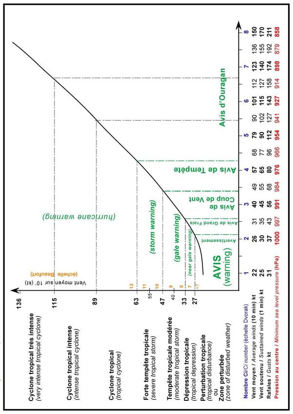
Tropical disturbance: tropical system in which the maximum of the average wind speed is estimated to
be not exceeding 27 knots (50 km/h, force 6 in the Beaufort scale)).
Tropical depression: tropical system in which the maximum of the average wind speed is estimated to be
in the range 28 to 33 knots (51 to 62 km/h, force 7 in the Beaufort scale).
Moderate tropical storm: tropical system in which the maximum of the average wind speed is estimated
to be in the range 34 to 47 knots (63 to 88 km/h, force 8 or 9 in the Beaufort scale).
Severe tropical storm: tropical system in which the maximum of the average wind speed is estimated to
be in the range 48 to 63 knots (89 to 117 km/h, force 10 or 11 in the Beaufort scale).
Tropical cyclone: tropical system in which the maximum of the average wind speed is estimated to be in
the range 64 to 89 knots (118 to 165 km/h, force 12 in the Beaufort scale).
Intense tropical cyclone: tropical system in which the maximum of the average wind speed is estimated to
be in the range 90 to 115 knots (166 to 212 km/h).
Very intense tropical cyclone: tropical system in which the maximum of the average wind speed is
estimated to exceed 115 knots (212 km/h).
Remnant low: a former tropical system that has weakened and is no longer associated with established
and/or organized convection. Within the related low-pressure circulation the maximum estimated average
wind does not exceed 27 knots (50 km/h, force 6 on the Beaufort scale).
* For converting the wind speeds of different averaging periods such as 1-min, 2-min, 3-min and 10-min, WMO Tropical Cyclone
Programme recommends to follow the guidelines as shown in the ATTACHMENT 1-C.
2016 EditionI-4
Filling low: a former tropical system undergoing sustained weakening and whose related minimum
pressure is rising.
Dissipating low: a former tropical system in the final decaying phase that is doomed to vanish rapidly.
Post-tropical depression: a former tropical system (tropical depression, tropical storm or tropical cyclone)
in the extra-tropical transition phase, which no longer presents all the characteristics of a tropical system
but has not yet completed its transition and cannot, therefore, be considered an extra-tropical depression
and qualified as such.
This is usually a transient stage lasting in most cases less than 24 hours.
Tropical system (or disturbance) characteristics:
Centre of the tropical system: geometric centre of the cloud eye or, if not discernible, the wind/pressure
centre.
Eye of the tropical system: relatively clear and calm area inside the circular wall of the convective clouds,
the geometric centre of which is the centre of the tropical system.
Centre fix of the tropical system: estimated location of the centre of a tropical system.
Confidence in the centre position: degree of confidence in the centre position of a tropical system
expressed as the radius of the smallest circle within which the centre may be located by the analysis.
“Position good", implies a radius of 30 nautical miles (55 km) or less,
"Position fair", implies a radius of 30 to 60 nautical miles (55 to 110 km) and
"Position poor“, implies a radius of greater than 60 nautical miles (110 km).
Direction of movement of the tropical system: direction towards which the tropical system centre is
moving.
Speed of movement of the tropical system: speed of movement of the centre of the tropical system.
Storm tide: actual sea level as influenced by a meteorological disturbance. The storm tide consists of the
normal astronomical tide and the storm surge.
Storm surge: difference between the actual water level as influenced by a meteorological disturbance
(i.e., the storm tide) and the level which would have been attained in the absence of the meteorological
disturbance (i.e., astronomical tide). Storm surge results from the shoreward movement of water
combined with the comparatively minor effects of low barometric pressure.
Marine Warnings:
Weather warning: meteorological message issued to provide appropriate warnings of hazardous weather
conditions.
Near gale warning: warning of mean wind speeds in the range of 28 to 33 knots (51 to 62 km/h, force 7 in
the Beaufort scale – i.e. near gale force).
Gale warning: warning of mean wind speeds in the range of 34 to 47 knots (63 to 88 km/h, force 8 or 9 in
the Beaufort scale – i.e. gale force).
Storm warning: warning of mean wind speeds in the range of 48 to 63 knots (89 to 117 km/h, force 10 or
11 in the Beaufort scale – i.e. storm force).
Hurricane warning: warning of mean wind speeds of 64 knots or higher (118 km/h or higher, force 12 in
the Beaufort scale).
2016 EditionI-5
Terms related to the warning system:
Cyclone advisory: priority message for exchanging information between national meteorological services
or meteorological offices concerning tropical/subtropical systems or incipient tropical/subtropical
systems : observational data of special significance (e.g., radar eye report), analyses (e.g. of satellite
imagery) ; forecasts (e.g. of movement), warnings issued nationally.
Cyclone season: in the South-West Indian Ocean, the cyclone season lasts from 1 July of year N to 30
June of year N+1, bearing in mind that tropical low-pressure systems are rare during the austral winter
(from June to September) and that the risk of cyclone formation is highest during the austral summer.
As the time period of cyclone risk varies over the basin, some Member countries of the Tropical Cyclone
Committee for the South-West Indian Ocean have defined, on the basis of their domestic needs, a
specific duration of the cyclone season, which is actually shorter (usually from November to April or May),
corresponding to the period when most of the disturbances likely to influence them occur.
1.3 Units used in international exchanges
(a) The following units/indicators are used for marine purposes:
(i) Distance in nautical miles, the unit (nm) being stated;
(ii) Location (position) by degrees and, where possible, tenths of degrees of latitude and
longitude expressed in words;
(iii) Direction to the nearest sixteen points of the compass or in degrees to the nearest ten,
given in words;
(iv) Speed (wind speed and rate of movement of systems) in knots, the unit (kt) being stated;
(v) Confidence in the centre position in nautical miles (nm);
(b) The following units/indicators are used in non-coded segments of exchanges, other than marine
bulletins:
(i) Distance in kilometres (km) or nautical miles (nm);
(ii) Location (position) by degrees and tenths of degrees in figures of latitude and longitude
and/or bearing on the sixteen point compass and distance from well-known fixed place(s);
(iii) Direction in degrees to the nearest 10, given in figures;
-1
(iv) Speed (wind speed and rate of movement of system) in kilometres per hour (km h ) or
knots;
(v) Confidence in the centre position in kilometres (km) or nautical miles (nm).
2016 EditionI-6
1.4 Classification of tropical systems adopted for use in the South-West Indian Ocean area of RA I
Note: The univocal pressure-wind relationship shown at the bottom of the diagram is purely indicative. In practice,
this relationship is adapted on a case by case basis in order to take into account the natural variability of the
pressure-wind relationship, which can be modified by parameters such as the intensity of the low-pressure system,
the size of the low-pressure circulation and the extension of related winds, the environmental pressure, latitude, the
speed of movement and the radius of maximum winds.
2016 EditionI-7
1.5 Identification and naming of tropical systems
Tropical and subtropical systems of the South-West Indian Ocean basin are identified by a
number attributed in chronological order of appearance within the cyclone season of reference. The
numbers are given and incremented sequentially by the RSMC la Reunion whenever it deems
appropriate to disseminate an advisory on a new system.
The numerical identifier will be supplemented by a name whenever the tropical or subtropical
system will reach a sufficient intensity and satisfy the naming criteria. This naming will facilitate the
designation and communication on the system. The naming criteria and naming procedure are detailed
hereafter.
A tropical or subtropical disturbance is named when it reaches the moderate tropical storm stage
(maximum average wind speed, as defined in paragraph 1.2.2, corresponding to gale force winds –
observed or estimated – present near the low-pressure centre in a significant portion of the cyclonic
circulation). When RSMC La Reunion or the sub-regional tropical cyclone advisory centre* in charge of
the area where the disturbance occurs (Madagascar, if the disturbance is centred west of 55°E, or
Mauritius, if the disturbance is centred between 55°E and 90° E) notices that the tropical or subtropical
disturbance in question approaches the intensity of a moderate tropical storm, the centres get in touch
and consult each other. If the technical consultation concludes that the moderate tropical storm stage
has been reached, the competent sub-regional centre formally names the disturbance.
The name is chosen, following alphabetical order, from a predefined list of names validated for
the basin and for the cyclone season of reference (starting each season with the name with the initial
letter “A”), except when a tropical system already named in the South-East Indian Ocean (east of 90° E)
shifts to the South-West Indian Ocean. In this case the original name is kept unchanged.
Meteorological services in the South-West Indian Ocean will use exclusively the designated
name to identify that tropical storm until it moves out of the area, becomes a post-tropical or extra-tropical
depression or, having weakened, ceases to qualify as a moderate tropical storm, in which case the storm
will continue to bear the given name preceded by “EX” in all bulletins associated with the system.
The procedure described above concerns exclusively the naming of tropical storms and does not
imply any restriction with regard to tropical cyclone warnings, which shall be broadcast in accordance with
the provision of chapter 5 applicable to both named cyclones and unnamed disturbances.
The list of names to be used in the South-West Indian Ocean area for identifying tropical (or
subtropical) storms that will develop during the next seasons within the area bounded by Equator to 40°S
west of 90°E to the east coast of Africa, has been established by the Committee at its twenty-first session
in September 2015. The names chosen (with genders and countries of origin) are included in the table of
next page.
It has also been decided during this twenty-first session that the three lists of names shown
hereafter will serve as the reference and basis to establish the future lists, for which only the names used
operationally during the cyclone seasons 2016 to 2019 will be withdrawn and replaced (by new names
provided by the Members and never used before).
2016 EditionI-8
CYCLONE SEASON CYCLONE SEASON CYCLONE SEASON
2016/2017 2017/2018 2018/2019
Names Provided by Names Provided by Names Provided by
ABELA Tanzania (F) AVA Madagascar (N) ALCIDE France (M)
BRANSBY South Africa (M) BERGUITTA Seychelles (F) BOUCHRA Comoros (F)
CARLOS Mauritius (M) CEBILE Zimbabwe (F) CILIDA Madagascar (F)
DINEO Botswana (F) DUMAZILE Swaziland (F) DESMOND South Africa (M)
ENAWO Malawi (F) ELIAKIM Kenya (M) EKETSANG Lesotho (M)
FERNANDO Mozambique (M) FAKIR Comoros (M) FUNANI Swaziland (M)
GABEKILE Swaziland (F) GUAMBE Mozambique (M) GELENA Tanzania (F)
HEROLD Seychelles (M) HABANA Botswana (M) HALEH Mauritius (F)
IRONDRO Madagascar (F) IMAN Mauritius (F) IDAI Zimbabwe (F)
JERUTO Kenya (F) JOBO Lesotho (M) JOANINHA Mozambique (F)
KUNDAI Zimbabwe (M) KANGA South Africa (N) KENNETH Seychelles (M)
LISEBO Lesotho (F) LUDZI Malawi (N) LORNA Kenya (F)
MICHEL France (M) MELINA Tanzania (F) MAIPELO Botswana (N)
NOUSRA Comoros (F) NATHAN France (M) NJAZI Malawi (F)
ONIAS Zimbabwe (M) OSCAR France (M)
OLIVIER Mauritius (M)
PELAGIE Madagascar (F) PAMELA Tanzania (F)
POKERA Malawi (F)
QUAMAR Comoros (M) QUENTIN Kenya (M)
QUINCY Seychelles (F)
RITA Seychelles (F) RAJAB Comoros (M)
REBAONE Botswana (N)
SOLANI Swaziland (M) SAVANA Mozambique (F)
SALAMA Comoros (F)
TARIK Mauritius (M) THEMBA Swaziland (M)
TRISTAN France (M)
URILIA South Africa UYAPO Botswana (N)
URSULA Kenya (F)
VUYANE Lesotho VIVIANE Mauritius (F)
VIOLET South Africa (F)
WAGNER Kenya (M) WALTER South Africa (M)
WILSON Mozambique (M)
XUSA Malawi XANGY Madagascar (M)
XILA Madagascar (M)
YARONA Botswana (N) YEMURAI Zimbabwe (F)
YEKELA Swaziland (M)
ZACARIAS Mozambique (M) ZANELE Lesotho (F)
ZAINA Tanzania (F)
* The term "Sub-regional Tropical Cyclone Advisory Centre" is agreed upon by the RA I Tropical Cyclone
Committee for use within the South-West Indian Ocean region by its Members. It has not been adopted by Regional
Association I or by any other WMO constituent body.
2016 EditionI-A-1
ATTACHMENT I-A
TERMS AND UNITS USED FOR NATIONAL PURPOSES
A. The meanings of terms used for national purposes by Members as indicated are given below:
National cyclone bulletin: A public release by a National Meteorological Service giving warnings or
warning information, where appropriate, along with details on a tropical cyclone. (This term is used by
Mozambique while in Mauritius it is called “Cyclone bulletin”). (Pro-formas used by various Members for
issue of national cyclone bulletins are given in Attachment I-B.)
Tropical cyclone warning: A warning against the possible disastrous effects of a tropical cyclone,
including the effects separately or jointly of hurricane force winds, torrential rainfall and dangerous sea
conditions. (This term is used by Mauritius and Mozambique).
B. Madagascar
1. Bulletin
Special meteorological bulletin: A bulletin issued by the Cyclone Forecasting Centre, Antananarivo for
broadcast by Radio Television Malagasy whenever a cyclone may affect an area of Madagascar or if a
change occurs in the development of a cyclone for which a previous warning has already been issued.
2. Categories of warnings
Preliminary warning: A warning issued by the Meteorological Service for the safeguard of the population
whenever a cyclone, which could threaten Madagascar in the 5 to 2 days ahead, has been detected by
the Meteorological Service. This warning is included in the special meteorological bulletin.
Warning of threat: A warning issued by the Meteorological Service for the safeguard of the population
when a cyclone directly threatens a part of Madagascar in the 48 to 24 hours ahead but the danger is not
imminent. This warning is included in the Special Meteorological Bulletin.
Warning of imminent danger: A warning issued by the Meteorological Service for the safeguard of the
population when a cyclone is threatening a part of Madagascar at short range (12 hours before impact)
and constitutes a danger for the population.
Safeguard warning: A warning issued by the Meteorological Service for the safeguard of the population
when a cyclone is moving away, cautioning during the ensuing 12 to 24 hours the population still
exposed against the residual hazards still in effect in the aftermath of the cyclonic storm and that may
constitute a danger.
C. Malawi
Categories of warnings
Information stage: Issued when the cyclone is within 45 and 55°East and 5 and 20°South. This is updated
every 24 hours.
Alert stage: This is issued when the cyclone is between 500 and 1,000 km from Malawi border, and is
likely going to affect the country. It is updated every 6 hours.
Warning stage: This is issued when the cyclone is within 500 km from Malawi border. It is updated every
3 hours.
2016 EditionI-B-1
ATTACHMENT I-B
PRO-FORMAS FOR ISSUE OF NATIONAL CYCLONE BULLETINS
(a) Pro-forma used by Tanzania
Cyclone bulletin No. (number) issued at (hour, date) by the Meteorological Office at (place) for (country)
and its coastal waters. At (time, date), (intensity) cyclone (name) was analyzed to be centred near
latitude f (place). Maximum wind speed of ... km/h/knots occurs ...
km/nm to the ... of the centre and hurricane force winds in excess of 117 km/h/63 knots extend outward
... km/nm from the centre. Cyclone (name) is forecast for the next ... hours to move towards the ... at ...
km/h knots and to (change in intensity).
The following warnings are issued:
Precautions to be taken include:
The next bulletin of this series will be issued at (time).
Message dispatched by
Authority Tel. No. or other Time dispatched
Dispatched
facility (local time)
AB XXXX ------ ------
CD XXXX ------ ------
EF XXXX ------ ------
GH XXXX ------ ------
(b) Pro-forma used by Madagascar
*
Special meteorological bulletin No. ...../ ....Time......./Date...................
- Name of the cyclone
- Intensity of the cyclone
- Position of the centre of the cyclone in relation to a publicly known landmark (cities or
geographical landmarks) in kilometres and in the 16 point compass.
- Forecast movement of the centre, direction in the 16 point compass and speed in
kilometres/hour.
- Developments and probabilities of occurrence (time and regions concerned) of the
meteorological phenomena accompanying the cyclone or the existing tropical system.
- Category of the alert followed by the name of the main place of the region concerned.
- Time of issuing.
- Sent by.
- Received by.
*
(c) Pro-forma used by Malawi and Mauritius
*
Initial of the depression or cyclone
*
Shortened version
2016 EditionI-B-2
(First, second, third . . . . . . . .) Cyclone bulletin issued at . . . . . . . hours (date).
Statement of warning status
Name, intensity, size of cyclone
Position of centre by distance and direction (and by latitude and longitude)
Movement of cyclone centre
Statement of probability and time of:
Hurricane wind (speed in gusts, direction)
Exceptional rainfall (indication of amount, if possible)
Storm surge (height, tide - applicable to Mauritius only for Mauritius, Rodrigues, St-Brandon,
and Agalega)
Reminders about precautions against damage: by wind
rain and floods
sea and coasts
Message dispatched by
Authority Tel. No. or other Time dispatched Dispatched
facility (local time)
AB XXXX ----- -----
CD XXXX ----- -----
EF XXXX ----- -----
GH XXXX ----- -----
2016 EditionI-C-1
ATACHMENT I-C
GUIDELINES FOR CONVERTING BETWEEN VARIOUS WIND AVERAGING PERIODS IN TROPICAL
CYCLONE CONDITIONS
This note is based on recommendations from Harper et al. (2010) and extracts from Knaff and Harper
(2010), providing advice on why, when and how “wind averaging conversions” can be made.
a) Why Convert Wind Speeds?
From the observational perspective, the aim is to process measurements of the wind so as to extract an
estimate of the mean wind at any time and its turbulence properties. From the forecasting viewpoint, the
aim is, given a specific wind speed metric derived from a process or product, to usefully predict other
metrics of the wind. Typically these needs revolve around the concept of the mean wind speed and an
associated peak gust wind speed; such that the statistical properties of the expected level of wind
turbulence under different exposures can be used to permit useful conversions between peak gust
wind speed estimates.
b) When to Convert Wind Speeds?
Wind speed conversions to account for varying averaging periods only apply in the context of a maximum
(peak gust) wind speed of a given duration observed within some longer interval. Simply measuring the
wind for a shorter period of time at random will not ensure that it is always higher than the mean wind
(given that there are both lulls and gusts). It is important that all wind speed values be correctly identified
as an estimate of the mean wind or an estimate of a peak gust.
Once the mean wind is reliably estimated, the random effects of turbulence in producing higher but
shorter-acting wind gusts, typically of greater significance for causing damage, can be estimated using a
“gust factor”. In order for a gust factor to be representative, certain conditions must be met, many of which
may not be exactly satisfied during a specific weather event or at a specific location:
Wind flow is turbulent with a steady mean wind speed (statistically stationary);
Constant surface features exist within the period of measurement, such that the boundary layer is
in equilibrium with the underlying surface roughness (exposure);
The conversion assumes the mean wind speed and the peak gust wind speed are at the same
height (e.g. the WMO standard observation height +10 m) above the surface.
c) How to Convert Individual Point-Specific Wind Speeds
Firstly, the mean wind speed estimate V should be explicitly identified by its averaging period To in
seconds, described here as VTo , e.g.
V600 is a 10-min averaged mean wind estimate;
V60 is a 1-min averaged mean wind estimate;
V3 is a 3-sec averaged mean wind estimate.
Next, a peak gust wind speed should be additionally prefixed by the gust averaging period , and the
time period over which it is observed (also termed the reference period), described here as V,To , e.g.
V60,600 is the highest 1-min mean (peak 1-min gust) within a 10-min observation period;
V3,60 is the highest 3-sec mean (peak 3-sec gust) within a 1-min observation period.
The “gust factor” G,To then relates as follows to the mean and the peak gust:
V ,To G ,To V ,
where the (true) mean wind V is estimated on the basis of a suitable sample, e.g. V600 or V3600.
On this basis, Table 1 provides the recommended near-surface (+10 m) conversion factors G,To between
typical peak gust wind averaging periods, which are a strong function of the exposure class because the
turbulence level varies depending on the surface roughness. Table 1 only provides a range of indicative
exposures for typical forecasting environments and Harper et al. (2010) or WMO (2008) should be
consulted for more specific advice regarding particular types of exposures - especially if it is intended to
calibrate specific measurement sites to “standard exposure”.
Table 1 Wind speed conversion factors for tropical cyclone conditions (after Harper et al. 2010).
2016 EditionI-C-2
Exposure at +10 m Reference Gust Factor G,To
Period Gust Duration (s)
Class Description
To (s) 3 60 120 180 600
3600 1.75 1.28 1.19 1.15 1.08
600 1.66 1.21 1.12 1.09 1.00
Roughly open
In-Land 180 1.58 1.15 1.07 1.00
terrain
120 1.55 1.13 1.00
60 1.49 1.00
3600 1.60 1.22 1.15 1.12 1.06
Offshore 600 1.52 1.16 1.09 1.06 1.00
Off-Land winds at a 180 1.44 1.10 1.04 1.00
coastline 120 1.42 1.08 1.00
60 1.36 1.00
3600 1.45 1.17 1.11 1.09 1.05
Onshore 600 1.38 1.11 1.05 1.03 1.00
Off-Sea winds at a 180 1.31 1.05 1.00 1.00
coastline 120 1.28 1.03 1.00
60 1.23 1.00
3600 1.30 1.11 1.07 1.06 1.03
600 1.23 1.05 1.02 1.00 1.00
> 20 km
At-Sea 180 1.17 1.00 1.00 1.00
offshore
120 1.15 1.00 1.00
60 1.11 1.00
Some example applications of the above recommendations are:
To estimate the expected “off-land” 3-sec peak gust in a 1-min period, multiply the estimated “off-
land” mean wind speed by 1.36
To estimate the expected “off-sea” 3-sec peak gust in a 10-min period, multiply the estimated “off-
sea” mean wind speed by 1.38
To estimate an “at-sea” 1-min peak gust in a 10-min period, multiply the estimated “at-sea” mean
wind speed by 1.05
Note that it is not possible to convert from a peak gust wind speed back to a specific time-averaged
mean wind – only to the estimated true mean speed. Hence to estimate the “off-sea” mean wind speed
given only a peak observed gust of 1-min duration ( = 60 s) measured in a 10-min period (To = 600 s),
multiply the observed 1-min peak gust by (1/1.11) = 0.90. This does not guarantee that the estimated
mean wind will be the same as the 10-min averaged wind at that time but, because the 10-min average is
normally a reliable estimate of the true mean wind, it will likely be similar. In all cases, measurement
systems should aim to reliably measure the mean wind speed and the standard deviation using a sample
duration of not less than 10-min (WMO 2008), i.e. V600. Additional shorter averaging periods and the
retaining of peak information should then be targeted at operational needs.
d) Converting Between Agency Estimates of Storm Maximum Wind Speed Vmax
This is a slightly different situation from converting a point specific wind estimate because the concept of
a storm-wide maximum wind speed Vmax is a metric with an associated spatial context (i.e. anywhere
within or associated with the storm) as well as a temporal fix context (at this moment in time or during a
specific period of time). While it may be expressed in terms of any wind averaging period it remains
important that it be unambiguous in terms of representing a mean wind or a peak gust. Agencies that
apply the WMO standard 10-min averaged Vmax wind have always applied a wind-averaging conversion
to reduce the maximum “sustained” 1-min wind value (a 1-min peak gust) that has been traditionally
associated with the Dvorak method (Dvorak 1984, Atkinson and Holliday 1977)1. As noted in the previous
section, it is technically not possible to convert from a peak gust back to a specific time-averaged mean
wind – only to the estimated true mean wind speed. However, in Harper et al. (2010) a practical argument
is made for nominal conversion between Vmax60 and Vmax600 values via an hourly mean wind speed
reference, and the recommendations are summarised in Table 2.
1 As detailed in Harper et al. (2010), this traditional assumption is without a firm basis.
2016 EditionI-C-3
It can be noted that the recommended conversion for at-sea exposure is about 5% higher than the
“traditional” value of 0.88 (WMO 1993), which is more appropriate to an off-land exposure. This has
special implications for the Dvorak method because “at sea” is the typical exposure of interest where such
conversions have been traditionally applied.
Table 2 Conversion factors between agency estimates of maximum 1-min and maximum 10-min
averaged tropical cyclone wind speed Vmax. (after Harper et al. 2010).
Vmax600=K Vmax60 At-Sea Off-Sea Off-land In-Land
K 0.93 0.90 0.87 0.84
e) References
Atkinson, G.D., and C. R. Holliday, 1977: Tropical cyclone minimum sea level pressure/maximum
sustained wind relationship for the Western North Pacific. Mon. Wea. Rev., 105, 421-427.
Dvorak, V.F., 1984: Tropical cyclone intensity analysis using satellite data. NOAA Tech. Rep. NESDIS
11, National Oceanic and Atmospheric Administration, Washington, DC, 47 pp.
Knaff, J.A. and B.A. Harper, 2010: Tropical cyclone surface wind structure and wind-pressure
relationships. In: Proc. WMO IWTC-VII, World Meteorological Organization , Keynote 1,La
Reunion, Nov.
Harper, B.A.,, J. D. Kepert, and J. D. Ginger, 2010: Guidelines for converting between various wind
averaging periods in tropical cyclone conditions. World Meteorological Organization, TCP Sub-
Project Report, WMO/TD-No. 1555.
WMO 1993: Global guide to tropical cyclone forecasting. Tropical Cyclone Programme Report No. TCP-
31, World Meteorological Organization, WMO/TD – No. 560, Geneva.
WMO 2008: Guide to meteorological instruments and methods of observation. World Meteorological
Organization , WMO-No. 8, 7th Ed, 681pp.
2016 EditionII-1
CHAPTER II
THE OBSERVING SYSTEM AND OBSERVING PROGRAMMES
2.1 Networks of synoptic land stations
The list of implemented regional basic synoptic network surface and upper air stations of
Members of the Committee is given in Table 1. Other stations are:
Index number Name of station
67003 FOMBONI (MOHELI)
67001 MORONI ICONI
67017 VOHEMAR
67023 SAMBAVA
67037 BESALAMPY
67107 ANTSIRABE
67131 MOROMBE
67273 ANGOCHE
67237 NAMPULA
67241 LUMBO
67285 PEBANE
67205 MOCIMBOA DA PRAIA
67231 CUAMBA
67221 MARRUPA
67346 CHANGALANE
67335 XAI XAI
2.1.1 The regional basic synoptic network
The list of implemented regional basic synoptic network surface and upper-air stations of
Members of the Committee is given in Table 1.
Additional surface observations at one-hourly intervals may be requested by any Member,
whenever a cyclone becomes an imminent threat to the Member, from the following stations:
Member Stations
France (La Réunion) All stations
Mauritius All stations
Comoros All stations
Madagascar All stations
and the following:
Index number Name of station
63881 Sumbawanga (0300-1800 UTC)
67215 Pemba
67237 Nampula
67283 Quelimane
67297 Beira
67323 Inhambane
67341 Maputo
Additional radiowind observations will be made at the synoptic hours indicated whenever a
named cyclone is within 500 km of the station, by the following stations:
2016 EditionII-2
Index number Name of station Time of observation
61995 Vacoas (Mauritius) 12 (radiosonde)
N.B. Requests shall be addressed by the Director of the National Meteorological Service making the
request to the Director of the National Meteorological Service concerned. A message
cancelling the request shall be sent as soon as additional observations are no longer required.
When a tropical cyclone is forecast to threaten a Member country, its NMC should initiate
enhanced observation programmes for its stations, to maximize its observational input to the RSMC La
Réunion, by increasing the coverage or increasing the scheduled frequency of observations.
2.1.2 Other networks
Surface observations at one-hourly intervals may be requested by any Member, whenever a
cyclone becomes an imminent threat to the Member, from the following additional stations:
Index number Name of station
*
67003 FOMBONI (MOHELI)
67017* VOHEMAR
67023* SAMBAVA
67037* BESALAMPY
67107* ANTSIRABE
67131* MOROMBE
67237 NAMPULA
The request should be addressed to the National Meteorological Service concerned.
2.2 Mobile ship stations
Whenever there is an intensifying tropical system in the area, all relevant NMSs should
endeavour to increase the number of ship observations in the immediate area of the disturbance by:
(a) Requesting relevant Voluntary Observing Ships (VOS) to make 3-hourly observations and to
include sea state groups as far as possible. This communication will take place through the
existing marine communications systems;
(b) Appealing to non-VOS vessels to send informal weather observations to the nearest NMS via
radio stations or other means of communication.
Both (a) and (b) could be achieved by adding the necessary text to all marine forecasts covering
the area of the disturbance. Alternatively, NMSs could contact directly vessels known to be in the area.
Member states receiving ship reports are urged to distribute the same to all other countries.
Members should transmit the observations – with the least delay – to the RSMC La Réunion
and the two Sub-regional Tropical Cyclone Advisory Centres in Mauritius and Madagascar.
2.3 Aircraft reports
Aircraft reports which are of particular importance for cyclone analysis or forecasting will be
exchanged on a priority basis.
The RSMC La Réunion - Tropical Cyclone Centre will, when possible, provide radar
observations, made from aircrafts on scheduled flights, giving the position of the cyclone centre as closely
as possible, when the centre is sufficiently close to the flight path to be detected.
*
Unlimited list. All stations are able to make hourly OBS
2016 EditionII-3
2.4 Special stations
2.4.1 Regional radar network
Members shall exchange, in particular, with the RSMC La Réunion - Tropical Cyclone Centre as
a first priority, radar information concerning cyclone eye fixes, as well as other radar data. For this
purpose, they may:
- use Part A of code form FMM 20 V - RADOB and/or apply the procedures described in
Table 2; or
- exchange the data in plain language by any appropriate means available (SSB, telefax,
telephone, etc.).
The example of Mauritius and Réunion has shown that this solution appears to be more flexible,
less demanding, thus more effective during cyclonic alert periods when operational staff is already kept
busy with other tasks.
The list of operational weather radar stations is as follows:
Station name Lat.°S Long.°E Wavelength Make
La Réunion 21 55 doppler 10 cm GEMATRONIK
Beira 20 35 10 cm MRL-5
Xai-Xai // // // //
Durban 29.707 31.081 10cm SELEX S-band
Ermelo 26.498 29.984 10cm SELEX S-band
Polokwane (Pietersburg) 23.500 29.420 10cm SELEX S-band
Skukuza 24.974 31.600 10cm SELEX S-band
_______________________
* Temporarily out of order
2016 EditionII-4
2.5 Meteorological satellites (ground segment)
2.5.1 APT/WEFAX/HRPT
In relation to the tropical cyclone detection, monitoring and forecasting services, Members will
operate and maintain satellite data reception equipment as follows:
. Botswana MSG Station at Gaborone
. Comoros MSG, SYNERGIE, Station at Moroni / Hahaya
. France (Réunion) Eumetcast, NOAA, FY2, PDUS, APT/WEFAX, HRPT and
MDD/PDUS Station at St. Denis
Kenya MSG, SYNERGIE, NOAA at Nairobi and Mombasa
. Lesotho MSG Station at Maseru
. Madagascar MSG, SYNERGIE, HRPT Station at Toamasina, Antananarivo
. Malawi MSG, SYNERGIE
. Mauritius PUMA, MESSIR and SYNERGIE workstations at Vacoas
. Mozambique MSG, Messir Station at Maputo
. Namibia ?
. Rep. of South Africa MSG, NINJO Station at Pretoria
. Seychelles MSG, SYNERGIE, PUMA Station at Mahé
. Swaziland MSG, SYNERGIE Station in Mbabane
. Tanzania MSG, SYNERGIE, Station at Dar-es-Salaam and
Synergie at Zanzibar, KIA and Mwanza
. Zimbabwe MSG, SYNERGIE, Station at Belvedere-Harare, Bulawayo
and Victoria Falls
In order to enable comparisons with each other of results obtained, Members and, in particular,
the RSMC La Réunion - Tropical Cyclone Centre, will exchange on a priority basis analyses of satellite
information on tropical cyclones. The text of cyclone advisories for this purpose will take the form:
(a) Time of picture, identification of satellite;
(b) Position of centre in degrees and tenths of degrees;
(c) Intensity: T number of estimated maximum wind speed and central pressure;
(d) Other characteristics deduced from the picture, e.g. development characteristics, estimated
extent of winds of specified speeds.
2.5.2 Data collection platforms (DCP)
2016 EditionII-5
The list of data collection platforms is as follows: (to be filled out by Members concerned)
WMO ID Locations Latitudes Longitudes
6399? Coetivy Island 07° 75’S 56° 15’E
63995 Aldabra Island 09° 24’S 46° 12’E
63994 Desroches Island 05°69’S 53° 65’E
63996 Farquhar Island 10°11’S 51° 18’E
63981 Praslin Island 04°19’S 46° 12’E
67017 Vohemar
67019 Analalava
67131 Morombe
67152 Ranohira
67079 Tsiroanomandidy 18°46S 46°03
DCP France (Réunion) (to be filled out by La Réunion)
61968 Îles Glorieuses
61970 Île Juan de Nova
61972 Île Europa
61976 Île Tromelin
2016 EditionII-6
TABLE 1 - LIST OF IMPLEMENTED OBSERVING STATIONS
Stations and observations programmes comprising the basic synoptic network
for tropical cyclone forecasting in the South-West Indian Ocean
Refer to WMO Volume A for an up-to-date list of stations and observational programmes.
2016 EditionII-7
TABLE 2 - RADAR EYE REPORTS - REPORTING PROCEDURES
Definition of eye or centre. Derive the eye or centre position from a continuous and logical sequence of
observations. Ideally, the radar-derived eye is readily apparent as an echo-free area, circular or oval in
shape, contained within the wall cloud. It is the geometric centre of this echo-free area that will be
reported as the eye location. If the wall cloud is not completely closed, it is still usually possible to derive
an eye location with a high degree of confidence by sketching the smallest circle or oval that can be
superimposed on the inner edge of the existing portion of the wall cloud. If the wall cloud is not well-
developed but a centre of circulation is identifiable then this feature should be observed and reported
similarly to an eye.
Terminology. If the central region of a storm is defined by an identifiable wall cloud, report the fix as an
"EYE". If a centre of circulation is recognizable but not well-defined by a wall cloud, report the fix as a
"CNTR". If the eye or centre is only occasionally recognizable, or there is some other reason to suspect
an uncertain central organization, the fix should be designated "PSBL EYE" or "PSBL CNTR". Include a
remark with eye fixes to indicate the degree of confidence in the fix. Qualifying remarks will not,
ordinarily, be applied to centre fixes. The following guidelines are meant to be suggestive rather than
absolute: If the wall cloud is closed, or almost closed, and the resultant eye is symmetrical, include as a
remark the phrase "GOOD FIX" in all observations. If the derived fix is believed to be useful although
ambiguous due to lack of completeness of the wall cloud, e.g. less than 50% or because of lack of
symmetry of the eye configuration, include the remark "POOR FIX". The phrase "FAIR FIX" will be used
to express an intermediate degree of confidence.
Use of spiral band overlays. Spiral band overlays may be used when the centre of the storm is over
water to estimate the location of the eye or centre whenever it is indistinct, out of range, or whenever the
radar beam is overshooting the centre of the storm. Normally at least 90 and preferably 180 degrees arc
of a spiral band must be present on the radarscope to assure a usefully accurate estimate of the storm's
centre position. Standard overlays are available with 10, 15 and 20 degrees crossing angles. Since the
crossing angle of a given band may increase from near zero degrees at the eye to more than twenty
degrees at distances over 170 km/90 nm from the centre, the most satisfactory results can be expected
by use of the spiral band overlay which best fits the intermediate portions of the band. Control setting
should be carefully adjusted to enhance the definition of the spiral bands. Depending on the particular
type of radar, it may be more convenient to trace the centres of the spiral bands on a map-type overlay
before fitting the spiral band overlay. If the eye position is determined principally by means of a spiral
band overlay, the report should indicate this. For example:
15 DEG SPRL OVERLAY EYE 2033S 6046E
Encoding location of eye or centre. Record and report co-ordinate positions of the eye or centre to the
nearest minute of latitude and longitude by means of unpunctuated five-character groups. A position of
18°35' south, 58°17 'east should appear on observation forms and teletype transmissions as 1835S
5817E. Record, but do not transmit, azimuth and range data from which coordinate positions are derived.
Movement of eye or centre. Determine the speed and direction of movement of an eye or centre from the
change of position measured over the previous one-hour interval. Report eye or centre movement by
using a four-digit group. Two digits will represent the hundreds and tens value of the direction, to the
nearest ten degrees, from which the eye or centre is moving. The third and fourth digits will represent the
speed in metres per second. For example, if the eye movement were determined to be from 096 degrees
at 7 metres per second, the movement group would be coded as 1007. Example:
MAURITIUS 150300 UTC EYE 2033S 6005E D55 1007 GOOD FIX
(where D55 means diameter of eye 55 kilometres).
2016 EditionIII-1
C H A P T E R III
TROPICAL CYCLONE ANALYSIS AND FORECASTING
3.1 Forecasting of tropical cyclone movement and changes in intensity
3.1.1 Regional arrangements
The responsibility for analysis and forecasting development and movement of tropical storms in
the area lies with the National Meteorological Service of each of the Members. However, in addition to
the exchange of observational data needed for analysis and forecasting, at present the main special
arrangements for co-operation and co-ordination in these matters are:
(a) Utilizing available regional observational and telecommunication networks and data processing
capacity, enhanced to the extent possible, the RSMC La Réunion - Tropical Cyclone Centre
shall issue advisory statements during cyclone occurrences at 6-hourly intervals, directed to
Pretoria RTH and Nairobi RSMC/RTH for distribution to NMCs, and to Toulouse for
dissemination via EUMETCAST, in respect of the following products:
Analysis:
(i) position of established tropical cyclones/depressions;
(ii) direction and speed of movement of each system;
(iii) central pressure of each system;
(iv) maximum wind and wind distribution of each system;
(v) reference to location of prominent synoptic features (ITCZ, upper troughs, etc.);
Prognosis:
(i) forecast positions of tropical systems at 12, 24, 36, 48, 60, 72 hours;
(ii) intensity (Wind) at 12, 24, 36, 48, 60, 72 hours;
Prognostic reasoning incorporating reference to:
(i) satellite imagery interpretation;
(ii) observational inferences and tendencies;
(iii) dynamic interpretation of interaction processes;
(iv) numerical weather prediction, climatological, persistence or statistical guidance.
On a similar basis the Sub-regional Tropical Cyclone Advisory Centres* should also issue
advisory statements, where appropriate, for their respective areas of responsibility (see Chapter IV,
section 4.1).
______________
* See footnote to Chapter I, section 1.5
2016 EditionIII-2
In addition to the above products, the RSMC La Réunion - Tropical Cyclone Centre will issue on
a routine basis the products indicated in Table 3. The list of those products will be issued through on
GTS or AFTN (Table 3).
(b) Each Member shall make full use of services provided by the RSMC La Réunion - Tropical
Cyclone Centre and, where applicable, by the Sub-regional Tropical Cyclone Advisory Centre*;
(c) Where considered necessary and feasible, there will be exchange of views on tropical storm
forecasts among the forecasters of the National Meteorological Services of the Members. This
exchange of views between forecasters will be preceded by an exchange of data as set out in
Chapters II and V.
The Sub-regional Tropical Cyclone Advisory Centre* in Madagascar will disseminate advisories
to Comoros and all Committee Members on the continent. The Sub-regional Tropical Cyclone Advisory
Centre* in Mauritius will disseminate advisories to Seychelles.
3.1.2 National activities
NMCs shall use available facilities to enable, to the maximum extent possible, speedy reception
of the above products, and adaptation for national purposes.
Information given in available tropical cyclone advisories and other guidance material will be
taken into consideration by National Meteorological Services when preparing tropical cyclone forecasts,
avoiding unnecessary duplication of monitoring effort except for fine tuning which may be advisable
through access to locally acquired radar surveillance data, ship reports, etc.
The prime role of the NMCs is to convert the technical information into meaningful severe
weather forecasts and warnings (strong winds, heavy precipitation and flooding, storm surge, rough seas
and swell and environmental damage) for national purposes in terms of the established national cyclone
warning system well-known to the community. NMCs may direct queries to the RSMC La Réunion -
*
Tropical Cyclone Centre or to the Sub-regional Tropical Cyclone Advisory Centre concerned, with
respect to possible amendments to the predicted behaviour of a tropical cyclone which may have become
apparent since receipt of the previous advisory statement.
3.2 Forecasting of storm surges and cyclonic swell
The responsibility for storm-surge and cyclonic swell forecasting lies with the national
Meteorological Service of the Member concerned. The RSMC La Réunion will however strive to provide
guidance whenever possible.
3.3 Forecasters’ tools
If possible, NMCs will put at the disposition of their forecasters the best tools such as work
stations.
3.4 Daily cyclone information Bulletin for the South-West Indian Ocean
The RSMC La Réunion provides, on a daily and yearly basis, a Cyclonic Information Bulletin for
the South-West Indian Ocean. This bulletin is bilingual (French and English) and available at 12 UTC.
The heading is AWIO21 (French edition) and AWIO20 (English edition) (Table 3).
The name adopted for the bulletin is the following:
French edition: “BULLETIN SUR L’ACTIVITE CYCLONIQUE ET LES CONDITIONS
METEOROLOGIQUES TROPICALES SUR LE SUD-OUEST DE L’OCEAN INDIAN”
English edition: “BULLETIN FOR CYCLONIC ACTIVITY AND SIGNIFICANT TROPICAL
*
* See footnote to Chapter I, section 1.5
2016 EditionYou can also read