Resilient Buffalo Niagara - Strategies to Respond to Climate Change - Climate Change Action Strategy Document - UB Regional Institute
←
→
Page content transcription
If your browser does not render page correctly, please read the page content below
Climate Change Action
                                           Strategy Document

Resilient
Buffalo Niagara
Strategies to Respond to Climate Change

Resilient Buffalo Niagara was prepared by Dr. Himanshu Grover,
University at Buffalo School of Architecture and Planning

DECEMBER 2014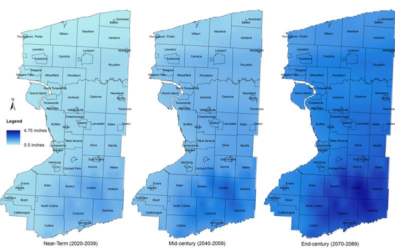
About this Strategy Document

                                      Resilient Buffalo Niagara
                                      Strategies to Respond to Climate Change

                                      This strategy document provides a broad policy framework for
                                      responding to the existing and anticipated impacts of climatic change
                                      already underway across the Buffalo-Niagara region. Effective climate
                                      change response primarily requires increased environmental sensitivity
                                      in day-to-day planning and development decision-making.
                                      The majority of climate change response strategies are rooted in
                                      ongoing local municipal planning initiatives such as land use planning,
                                      transportation planning, building codes, and hazard mitigation.
                                      As such this report highlights important considerations that local
                                      decision makers need to be sensitive to when implementing such local
                                      developmental planning actions.
                                      A critical aspect of climate change response is limiting existing
                                      greenhouse gas emissions without compromising local economic growth
                                      and development. In light of this, the report recommends broad policy
                                      considerations to guide local decision making to limit greenhouse gas
                                      emissions without hindering economic prosperity.
                                      With respect to direct local impacts from climate change, present models
                                      indicate marginal changes in normal temperature and precipitation
                                      patterns by mid-century. However, it is very likely that the resultant
                                      societal impacts will be heightened by existing vulnerabilities in the
                                      local physical infrastructure and social systems. Therefore, this report
                                      undertakes a regional assessment of such vulnerabilities, highlighting
                                      communities of relatively higher concern that need to undertake further
                                      detailed assessments at the local level.
                                      In summary, this is a regional climate change response strategy
                                      document that provides a blueprint for advising local development
                                      actions to avoid further increases in community exposure to climate
                                      change risks, and rather enhance community resilience along with gains
                                      in local quality of life.

                                      Recommended Citation: Grover, Himanshu, Margaret Smith, Yanjia Cao and Yi Yang. 2014.
                                      Resilient Buffalo Niagara: Strategies to Respond to Climate Change. University at Buffalo Regional
                                      Institute, State University of New York at Buffalo, School of Architecture and Planning.

2   Climate Change Action Strategy Document: Resilient Buffalo Niagara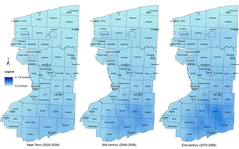
This document was produced as part of One Region Forward,
  a regional initiative to promote more sustainable forms of
  development in Erie and Niagara counties. Research, analysis,
  and planning for this report were led by Dr. Himanshu Grover of
  the University at Buffalo, School of Architecture and Planning
  at the State University of New York. Funding was provided by
  the US Department of Housing and Urban Development through
  its Partnership for Sustainable Communities, an interagency
  collaboration also involving the US Department of Transportation
  and the Environmental Protection Agency.

  AUTHORSHIP

  Authors: Himanshu Grover, Margaret Smith, Yanjia Cao, Yi Yang

  Principal Investigator: Robert G. Shibley, FAIA, AICP

  ACKNOWLEDGEMENTS
  Numerous individuals, organizations, and groups throughout the Buffalo-Niagara
  region have contributed generously with their ideas and time for this report.

  Climate Change Action Working Group Members
  Dr. Lynda Schneekloth, UB Regional Institute (Team Facilitator)
  Sean Myers, NBT Solutions LLC
  Terry Yonker, Western New York Environmental Alliance
  Bill Nowak, Buffalo Geothermal Heating and Cooling
  Padma Kasthurirangan, Niagara Wind and Solar
  Lou Paonessa, Niagara Power Project
  Bill Smith, Buffalo Niagara Medical Campus
  Thomas Hersey, Erie County Department of Environment and Planning
  Liz Santacrose, Ecology & Environment
  Kelly Tyler, New York State Energy Research and Development Authority
  Jim Simon, University at Buffalo Office of Sustainability
  Aliesa Adelman, Wendel Companies
  UB Regional Institute Research and Support Team: Bart Roberts, Bradshaw Hovey,
  Brian Conley, Brenda Stynes, Darren Cotton, Teresa Bosch de Celis, Matt Wattles, Laura
  Quebral, Kathryn Friedman, Paul Ray, Sharon Ana Entress, Emily Gibson (Graduate
  Assistant).

  The work that provided the basis for this publication was supported by a U.S. Department
   of Housing and Urban Development (HUD) Sustainable Communities Regional Planning
Grant. The author and publisher are solely responsible for the accuracy of the statements and
 interpretations contained in the publication. Such interpretations do not necessarily reflect
                            the views of the Federal Government.

                 Climate Change Action Strategy Document: Resilient Buffalo Niagara          3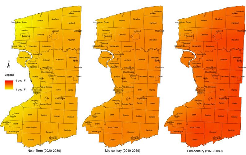
Table of Contents
INTRODUCTION                                                                                                                                                                                           12
   A. What Does this Plan Provide?.  .  .  .  .  .  .  .  .  .  .  .  .  .  .  .  .  .  .  .  .  .  .  .  .  .  .  .  .  .  .  .  .  .  .  .  .  .  .  .  .  .  .  .  .  .  .                          13
   B. Climate Change Response Planning Goals.  .  .  .  .  .  .  .  .  .  .  .  .  .  .  .  .  .  .  .  .  .  .  .  .  .  .  .  .  .  .  .  .  .  .  .  .                                              13
   C. Resilient Buffalo Niagara Response Strategy .  .  .  .  .  .  .  .  .  .  .  .  .  .  .  .  .  .  .  .  .  .  .  .  .  .  .  .  .  .  .  .  .  .  .                                              13
   D. Organization of the Report .  .  .  .  .  .  .  .  .  .  .  .  .  .  .  .  .  .  .  .  .  .  .  .  .  .  .  .  .  .  .  .  .  .  .  .  .  .  .  .  .  .  .  .  .  .  .  .  .                     14
GREENHOUSE GAS EMISSIONS                                                                                                                                                                               16
   A. Emissions from Electricity Consumption . .  .  .  .  .  .  .  .  .  .  .  .  .  .  .  .  .  .  .  .  .  .  .  .  .  .  .  .  .  .  .  .  .  .  .  .  .                                           16
   B. Residential Building Emissions from Stationary Combustion.  .  .  .  .  .  .  .  .  .  .  .  .  .  .  .  .  .  .  .  .  .                                                                        16
   C. Transportation .  .  .  .  .  .  .  .  .  .  .  .  .  .  .  .  .  .  .  .  .  .  .  .  .  .  .  .  .  .  .  .  .  .  .  .  .  .  .  .  .  .  .  .  .  .  .  .  .  .  .  .  .  .  .  .  .  .  .   17
   D. Future Outlook.  .  .  .  .  .  .  .  .  .  .  .  .  .  .  .  .  .  .  .  .  .  .  .  .  .  .  .  .  .  .  .  .  .  .  .  .  .  .  .  .  .  .  .  .  .  .  .  .  .  .  .  .  .  .  .  .  .  .    17
PHYSICAL VULNERABILITY TO CLIMATE CHANGE                                                                                                                                                               19
   A. Projected Impacts in Upstate New York.  .  .  .  .  .  .  .  .  .  .  .  .  .  .  .  .  .  .  .  .  .  .  .  .  .  .  .  .  .  .  .  .  .  .  .  .  .  .                                         20
   B. Expected Climatic Changes in the Buffalo Niagara Region.  .  .  .  .  .  .  .  .  .  .  .  .  .  .  .  .  .  .  .  .  .  .  .                                                                    21
   D. Other Local Risks from Climate Change.  .  .  .  .  .  .  .  .  .  .  .  .  .  .  .  .  .  .  .  .  .  .  .  .  .  .  .  .  .  .  .  .  .  .  .  .  .  .                                         28
SOCIAL VULNERABILITY ASSESSMENT                                                                                                                                                                        33
   A. Methodology Adopted for this Study. .  .  .  .  .  .  .  .  .  .  .  .  .  .  .  .  .  .  .  .  .  .  .  .  .  .  .  .  .  .  .  .  .  .  .  .  .  .  .  .                                       34
   B. Spatial Distribution of Social Vulnerability Indicators.  .  .  .  .  .  .  .  .  .  .  .  .  .  .  .  .  .  .  .  .  .  .  .  .  .  .  .                                                        35
   C. Overall Social Vulnerability Index .  .  .  .  .  .  .  .  .  .  .  .  .  .  .  .  .  .  .  .  .  .  .  .  .  .  .  .  .  .  .  .  .  .  .  .  .  .  .  .  .  .  .  .                            38
SYNERGISTIC CLIMATE CHANGE RESPONSE STRATEGIES                                                                                                                                                         41
   A. Proposed Climate Change Response Strategies .  .  .  .  .  .  .  .  .  .  .  .  .  .  .  .  .  .  .  .  .  .  .  .  .  .  .  .  .  .  .  .                                                       41
   C. Importance of Outreach and Education .  .  .  .  .  .  .  .  .  .  .  .  .  .  .  .  .  .  .  .  .  .  .  .  .  .  .  .  .  .  .  .  .  .  .  .  .  .                                            48
   C. Opportunities for Collaborative Implementation .  .  .  .  .  .  .  .  .  .  .  .  .  .  .  .  .  .  .  .  .  .  .  .  .  .  .  .  .  .  .                                                       49
APPENDICES                                                                                                                                                                                             52

4                       Climate Change Action Strategy Document: Resilient Buffalo Niagara
Figures
Figure 1. Residential Building Emissions from Stationary Combustion                                                         17
Figure 2. Emissions from On-Road Vehicles                                                                                   18
Figure 3. Annual Vehicle Miles Travelled Per Household (2010)                                                               18
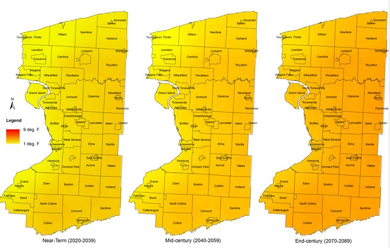
Figure 4. Projected Changes in Annual Mean Temperatures under Scenario B1 (Lowest Emissions)                                20
Figure 5. Projected Changes in Annual Mean Temperatures under Scenario A1 (Medium Emissions)                                21
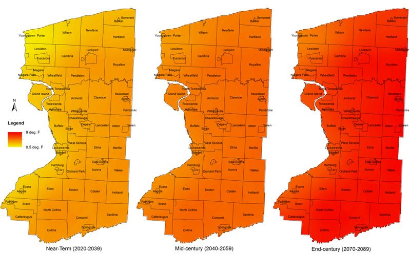
Figure 6. Projected Changes in Annual Mean Temperatures under Scenario A2 (Highest Emissions)                               22
Figure 7. Projected Changes in Annual Mean Precipitation under Scenario B1 (Lowest Emissions)                               23
Figure 8. Projected Changes in Annual Mean Precipitation under Scenario B1 (Lowest Emissions)                               23
Figure 9. Projected Changes in Annual Mean Precipitation under Scenario A2 (Highest Emissions) )                            24
Figure 10. Expected changes in the Climate of Upstate New York.                                                             25
Figure 11. Anticipated Heat Waves in Buffalo based on three climate models                                                  25
Figure 12. Estimated Percentage of Area at Risk from 1% Annual Chance of Flooding                                           26
Figure 14. Social Vulnerability Indicator – Population Above 65 yrs.                                                        35
Figure 13. Social Vulnerability Indicator - Median Home Values                                                              35
Figure 15. Social Vulnerability Indicator – African Americans                                                               36
Figure 16. Social Vulnerability Indicator - Unemployment                                                                    36
Figure 17. Social Vulnerability Indicator - Poverty                                                                         37
Figure 18. Social Vulnerability Indicator- Education                                                                        37
Figure 19. Social Vulnerability Indicator- Single Parent female-headed Households                                           38
Figure 20. Social Vulnerability Indicator - Households with Social Security Income                                          38
Figure 21. Social Vulnerability Indicator - Primary Extractive Sectors Employment                                           39
Figure 22. Overall Social Vulnerability Index                                                                               39
Figure 23. Synergistic Climate Change Response Strategy                                                                     42

Tables
Table 1. Energy Consumption Related Emissions                                                                               17
Table 2. Total Value of Residential Property at Risk from Flooding (Analysis based on GIS overlay
of 2010 NYS Office of Real Property System (RPS) parcel center points with 2010 FEMA Q3 Digital Floodplains)                27
Table 3. Selected Indicators of Social Vulnerability                                                                        34

                                                       Climate Change Action Strategy Document: Resilient Buffalo Niagara        5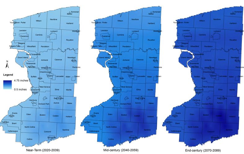
6 Climate Change Action Strategy Document: Resilient Buffalo Niagara
EXECUTIVE SUMMARY

This Climate Change Response Strategy        the end of this century based on three-          bring together traditional adaptation,
Plan, “Resilient Buffalo-Niagara”, is        emission scenario of: low emissions,             mitigation, and efficiency policies to
one of the first initiatives in the nation   medium emissions, and high emissions.            enhance local resilience to climate
to propose a comprehensive and               This analysis reveals that impacts               change. The hallmark of the proposed
integrated response to the challenge         under low emission scenario will be              climate change response strategy is the
of climate change. Buffalo-Niagara           marginal, but will be significantly              adoption of a balanced approach that
region is located between two Great          higher under medium and high                     emphasizes reduction of greenhouse
Lakes - Lake Erie and Lake Ontario.          emission scenarios. Under all scenarios,         gasses, efficiency and conservation of
Historically, except for significant lake-   southern tier communities will be the            resources, and sustainable development
effect snowfall, this region has not         first to experience significant changes          policies that will enhance local resilience
experienced any major natural hazards.       in the local conditions. Climate change          to climate change and result in an
However, this does not preclude it from      risks in this region will be exacerbated         equitable and sustainable growth in
the negative impacts of climate change.      by existing vulnerabilities in the local         the region. This report thus outlines
The detailed vulnerability assessment        infrastructure, and unsustainable                an ambitious, yet achievable, vision of
undertaken in this report reveals that       development patterns.                            community resilience through local
as the world’s climate continues to                                                           action.
                                             This report also analyzes the patterns of
change, and weather patterns become          social vulnerability in the region. This
more unpredictable, the future will          perspective highlights the differences
not be as safe. This region too will face    in local adaptive capacities among the
an increasing number of hazards and          various communities in the region.
risks. In order to realize the vision of     Analysis of nine social vulnerability
sustainable and equitable development        variables reveals that Cities of Buffalo,
in the region, local communities will        Lockport, Lackawanna, Tonawanda
need to consider existing and future         and Niagara Falls, Towns of Newfane,
vulnerabilities when formulating future      Somerset, Royalton, Cheektowaga, Brant,
development policies. This report, as part   Collins, and Concord, and the villages
of the One Region Forward initiative         of Springville and Sloan are of greatest
for the region, will serve as a guide for    concern. These communities will
local authorities in preparing for climate   greater needs, but limited resources to
change.                                      implement an effective climate change
This report undertakes a critical            response strategy.
evaluation of local vulnerability to         Based on the vulnerability analysis,
future impacts of climate change. This       a number of strategic response
report utilizes downscaled data from         options are presented in this report
climate change projections generated by      to minimize risk from future impacts
the Community Climate System Models          of climate change. This report adopts
(CCSM). Changes in local temperature         a synergistic approach that seeks to
and precipitation are analyzed until

                                                           Climate Change Action Strategy Document: Resilient Buffalo Niagara          7
1.

INTRODUCTION

 There is now overwhelming evidence               However, it is widely feared that most      rainfall. These changes are likely to be
confirming that changing weather                  of the ecosystem services that we           accompanied with an increasing number
conditions, increasing frequency of               depend on for our continued growth          of days with extreme temperatures as
extreme events, and growing losses                and prosperity are at existential risk      well as localized flooding due to more
from hydro-meteorological events are              from climate change. This certainty of      intense rain events. Changes in the
clearly attributed to climate-related             changes coupled with uncertainty with       local climatic system will also lead to
stresses, combined with the socio-                respect to the exact nature, extent, and    secondary impacts such as decreased
economic and structural vulnerabilities           severity of risks lends urgency to the      agricultural productivity, shifts in
of human systems. Since 1900, the                 need to address climate change at the       the ecological distribution of forests
average temperature in the Northern               local and regional scales.                  and plants, changes in urban run-
Hemisphere has increased by 1oF,                  The Buffalo Niagara region is situated      off, and increased seasonal variation
growing seasons have lengthened, and              along two famous Great Lakes: Erie and      in lake levels. The impacts of these
precipitation has increased significantly         Ontario. This geographical location         changes will be further exacerbated
(Rogelj, Meinshausen, and Knutti 2012).           creates unique climatic features            by existing vulnerabilities and
During the same period, the number of             that are highly sensitive to local and      unsustainable development practices
hydro-meteorological events has also              regional changes in weather and climate     in local communities, such as urban
increased from less than 10 per year              conditions. Historically, this region       expansion in low-lying areas, a lack of
to more than 340 per year (Center for             experiences extreme snowstorms during       cohesive infrastructure management
Research on Epidemiology of Disasters             the late fall and winter months, due        and redevelopment strategies, and
(CRED), 2007).                                    to cold air that sweeps across warmer       income inequality, among other existing
Historically, natural climatic variability        lakes, picking up heat and moisture, and    socio-economic challenges. As the
has been the primary cause of extreme             depositing large amounts of snow along      impacts of climate change become more
events, but the recent rise in weather            the lee side of the lakes. This phenomena   conspicuous there will be increased
related extreme events is most likely             causes Buffalo to receive an average of     stress on urban infrastructural
due to climatic changes caused by                 92 inches of snowfall per year (Kunkel,     facilities such as energy generation and
anthropogenic, or human-caused,                   Westcott, and Kristovich 2002). While       distribution, water supply, drainage,
emissions. This scientific consensus on           heavy lake-effect snowfall represents       and wastewater management. Most
the role of greenhouse gases in causing           a potential natural hazard for local        notably, it is also expected that fresh
climate change is clearly expressed               communities, it also plays an important     water scarcities elsewhere may drive
in most scientific international and              role in winter recreational activities,     unprecedented changes in local
national organizations, including the             agriculture, environmental health, and      economic and demographic patterns in
Intergovernmental Panel on Climate                regional hydrology. Occurrence of these     this region.
Change (IPCC) and the National                    events is directly linked to temperature    These risks represent the most
Academy of Sciences (NAS) (Oreskes                changes in the Northern Hemisphere,         likely direct and indirect impacts of
2004). While the impacts of increasing            and local lake surface conditions (e.g.,    anticipated climatic changes based on
greenhouse gases are starting to become           air temperature, lake-air temperature       the existing estimates of greenhouse
evident in common weather measures                differences, wind speed, and wind           gas emissions and the commonly
of temperature and rainfall, the impacts          direction). As regional climatic changes    accepted range of climate change
of climate change on plants, animals,             become more overt, the Buffalo Niagara      model simulations. While recognizing
and ecosystems is still unclear. It is also       region will undoubtedly experience          the uncertainty in predicting the exact
uncertain if and how these species and            changes in its existing patterns of lake-   extent and nature of changes, this
systems will adapt to climate change.             effect snowfall.                            report adopts a synergistic planning
                                                  Other direct impacts of climate change      framework to outline an informed
                                                  will manifest themselves in the forms       climate change policy response for the
                                                  of increasing mean temperatures and         region.

8               Climate Change Action Strategy Document: Resilient Buffalo Niagara
INTRODUCTION

   Extreme Lake-Effect Snowfall                                                                    Goal 5
   In 2006, the lake-effect snowstorm in October dropped 24” of snow in the region                 Identify actions that will support the
   over a 16-hour period. This off-season snow event crippled life across the region               continued sustainability of the Great
   and resulted in losses worth millions of dollars. (Photograph courtesy NOAA)                    Lakes and other natural resources in
                                                                                                   the region.

                                                                                               C. Resilient Buffalo Niagara
                                                                                                 Response Strategy
                                                                                               Traditionally climate change response
                                                                                               policies have been classified into
                                                                                               mitigation and adaptation responses.
                                                                                               Mitigation refers to policies that aim to
                                                                                               limit the severity of climatic changes by
                                                                                               controlling greenhouse gas emissions
                                                                                               and increasing the number of natural
                                                                                               “sinks” that absorb emissions, such
                                                                                               as forests. Adaptation on the other
                                                                                               hand primarily aims at controlling the
                                                                                               intensity of climate change impacts
                                                                                               through a range of intervention policies
                                                                                               to build resistance and resilience in
                                                                                               vulnerable systems. Climate change
                                                                                               research literature documents
A. What Does this Plan                       B. Climate Change Response                        significant fundamental differences
  Provide?                                     Planning Goals                                  between the two approaches as well
                                                                                               as potential conflicts between the two
This climate change response strategy        The following goals serve as a guide              (Cohen et al. 1998, Christensen, Halsnæs,
document will serve as a guide to local      for the research analysis and policy              and Sathaye 1998). These differences
municipalities in the Buffalo Niagara        recommendations that follow in the                relate to temporal scales, effective
region to prepare for and respond to the     subsequent sections. In addition to the           spatial scales, measures of cost-benefit
local impacts of climate change. This        analysis of the existing regional climate         analysis, and the appropriate actors for
plan focuses on building community           change and development challenges,                policy implementation.1
resilience to minimize losses from           these goals were also informed by
climatic changes, while at the same          discussions of the Climate Change                 Despite the differences between these
time supporting the sustainable              Action Working Team organized as part             two policy options, they are also viewed
development of the region. It is expected    of the regional sustainable development           as being complementary to each
that proactive planning for climate          planning initiative, One Region Forward.          other (King 2004, Tol 2005, and Adger
change will prove to be economical and                                                         2001a). Mitigation policies will help
                                                Goal 1                                         reduce the need for adaptive actions by
beneficial for the region by significantly
reducing future costs of redesigning,           Provide appropriate guidance and               reducing the threat of climate change.
rebuilding, and retrofitting numerous           information on related issues and              At the same time, adaptation policies
types of infrastructure as a result of          challenges to ensure that local                will help reduce the residual impact
climate change impacts.                         communities are better prepared in             of unavoidable climatic changes.
                                                the face of changing climatic trends           Economically, mitigation policies
Since this plan is primarily meant                                                             are likely to be more cost effective as
                                                in the region.
to guide local municipal action, the                                                           they focus on decreasing risks, and
analysis and results focus on sectors           Goal 2
                                                                                               thereby reducing the need for adaptive
and services that are typically under           Outline a balanced approach to                 actions. However, it is imperative that
local jurisdiction. Other sectors within        addressing climate change through              a meaningful climate change response
the jurisdiction of state or federal            a combination of mitigation and                strategy plan explore both kinds of
agencies have not been addressed in             adaptation measures.                           policy options.
thorough detail. For example, the impact
of climate change on water levels and           Goal 3                                         There is an intuitive appeal to
quality of marine resources in Lake             Evolve a comprehensive methodology             creating synergies between the two
Erie and Lake Ontario is expected to be         for climate change vulnerability               policy responses, since that is likely
quite significant, but the adaptation           assessment that can be implemented             to produce the most economical and
actions required to address these issues        across the region.                             efficient outcomes. At the same time it
fall outside of the control of local                                                           is important to recognize that climate
                                                Goal 4                                         change policy responses cannot happen
communities. Therefore, these broader
issues have not been addressed in detail        Encourage strategies with tangible             in isolation. Rather, they need to be
in this plan. However, related issues           benefits across multiple sectors that          integrated with other environmental
of urban development and managing               will also contribute to local economic         and developmental concerns. Climate
surface run-off in the local watershed,         growth and wealth creation.
                                                                                               1 Refer to Fussel and Klein (2006) for a comprehensive
which are within the political control of
                                                                                               analysis of differences between mitigation and
local jurisdictions, have been addressed                                                       adaptation policy options.

                                                            Climate Change Action Strategy Document: Resilient Buffalo Niagara                          9
change policies that provide additional                        existing vulnerabilities within the                            change response strategy that is
local benefits are likely to face lesser                       study area. An important aspect of                             sensitive to both local environmental
institutional resistance and gather                            such an approach is an assessment of                           and developmental priorities. The
broader public support. It is envisaged                        inherent vulnerabilities3. It is expected                      sensitivity of a community is an a priori
that the adoption of such a synergistic                        that as a community addresses these                            or inferable condition of a community
approach will enable policy makers to                          vulnerabilities, it will become more                           that is determined by a variety of socio-
choose a balanced mix of policies based                        resilient and will be able to cope with the                    economic and political factors (Blaikie
on specific local concerns and priorities.                     increased risks as well as uncertainties                       et al. 1994, Adger 2001b).6 This report
Another critical aspect of climate change                      from changing climatic conditions.                             utilizes commonly used indicators for
response strategy is the identification of                     Local programs and policies that reduce                        assessing community sensitivity. It
opportunities to promote efficiency in                         existing vulnerabilities will undoubtedly                      is anticipated that attention to these
existing systems. However, this aspect                         increase community resilience and                              factors will result in beneficial outcomes
relating to modification in existing                           consequently reduce overall exposure                           not only in terms of an effective climate
systems to promote efficiency has                              to the impending impacts of climate                            change response policy but also viable
been largely ignored in most plans.                            change.                                                        local sustainable development priorities.
For example, managing existing water                           This strategy document analyzes climate
demands in a community can lead to                             change vulnerability with respect to                           D. Organization of the
adaptation benefits by reducing the                            three dimensions: one external and
increased demand for water due to                              two internal. The external dimension
                                                                                                                                Report
rising temperatures. It can also provide                       is represented by Buffalo Niagara’s                            The following chapter two analyzes
mitigation benefits by reducing the                            exposure to expected changes in the                            the external threats (exposure) from
energy costs of the water supply system.                       climatic systems. This is a scenario-                          anticipated changes in the climatic
At the same time, water demand                                 based analysis that relies on outputs                          system. Geographical distribution
management also promotes the overall                           obtained from complex models that                              of climate change risks is analyzed
sustainability of the community.                               predict sub-regional impacts based                             using Geographic Information
However, such strategies are often                             on estimates of global greenhouse                              Systems (GIS). In addition to the
addressed only in sustainability plans                         gas emissions.4 These outcomes are                             direct effects on temperature and
or individual sector plans, and do not                         discussed in terms of direct impacts                           precipitation, this report also analyzes
receive adequate attention in climate                          on the local weather variables of                              the secondary impacts that are likely to
change response strategies.                                    temperature and precipitation, and                             be experienced in the region. Chapter
This strategy plan addresses the above                         secondary impacts of increased threats                         three briefly summarizes the existing
issues by suggesting a mix of mitigation,                      from natural environmental hazards as                          local greenhouse gas contributions.
adaptation, and conservation                                   well as changes to natural ecosystems.                         The underlying estimates were not
strategies as part of a broader climate                        The two internal dimensions include                            conducted as part of this plan. Rather,
change resilience policy response.                             local greenhouse gas emissions                                 they are based on the assessments
The policies proposed in this plan are                         contributions and local sensitivity to                         undertaken as part of the 2013Western
likely to provide synergistic benefits                         the anticipated impacts. Local emissions                       New York Regional Sustainability Plan.
across a range of environmental and                            contributions are estimated across                             Chapter four presents a detailed analysis
development priorities. The selection of                       various local sectors and primarily                            of local sensitivity to climate change
such synergistic strategies is achieved by                     rely on estimates developed as part of                         across the various communities in Erie
adopting a resilience-centered approach                        the 2013 Western New York Regional                             and Niagara counties. Using common
wherein the risks from climate change                          Sustainability Plan.5 While there is                           indicators of social vulnerability,
are seen as a cumulative outcome of                            no way to predict the direct marginal                          the variation between different
anticipated impacts of changing climatic                       adaptation benefits of controlling local                       communities in the region is analyzed
conditions and existing susceptibilities                       emissions, it does focus attention to the                      and communities of higher concern
in local systems (e.g., socio-economic                         root cause of the problem. Non-tangible                        are identified. The final chapter of this
and physical infrastructure). The                              benefits of including mitigation as an                         report discusses a range of response
proposals are formulated to address                            important climate change response                              strategies recommended for minimizing
these local vulnerabilities and build                          strategy include increased attention                           the previously identified regional
local resilience to climate change, while                      to climate change issues in local policy                       impacts of climate change.
promoting regional sustainability.                             making. Another benefit is the provision
                                                               of more policy options to enable policy
This approach is particularly useful                           makers to adopt a balanced climate
given the uncertainty associated
with climate change impacts.2 We                               3 Vulnerability, according to the IPCC (2001), is an
                                                               integrated measure of the expected magnitude of
believe that despite the lack of fine
                                                               adverse effects to a system caused by a given level of
scale local climate change impact                              certain external stressors. It is defined as: “The degree
assessment data, an effective adaptive                         to which a system is susceptible to, or unable to cope
response strategy can be formulated                            with, adverse effects of climate change, including climate
                                                               variability and extremes. Vulnerability is a function of
through critical assessment of the
                                                               the character, magnitude, and rate of climate variation to
                                                               which a system is exposed, its sensitivity, and its adaptive
                                                               capacity.”
2 Uncertainty in predicting the exact nature and extent
of climate change is greater at the local level due to the     4 Discussed in further detail in Chapter 3. This is also
limitations of climate change models in representing the       referred to as physical vulnerability or place vulnerability
complex interactions and mechanisms that impact local          in disaster research literature.                               6 This is referred to as “social vulnerability” in the
climatic conditions. For a detailed discussion on this topic   5 This plan was prepared under Phase I of the Cleaner,         disaster research literature (see Kasperson et al. 1988,
see Heal and Kristrom (2002).                                  Greener Communities Program, sponsored by NYSERDA              Cutter, Boruff, and Shirley 2003).

10                    Climate Change Action Strategy Document: Resilient Buffalo Niagara
INTRODUCTION
Chapter References
Adger, W. N. 2001a. “Scales of governance and environmental justice for
adaptation and mitigation of climate change.” Journal of International
Development 13 (7):921-931.
Adger, W. N. 2001b. “Social Capital and Climate Change.” Tyndall Centre for
Climate Change Research Working Paper 8:39–41.
Blaikie, P, T Cannon, I Davis, and B Wisner. 1994. At Risk: Natural Hazards,
People’s Vulnerability and Disasters. London: Routledge.
Christensen, John M, Kirsten Halsnæs, and J Sathaye. 1998. Mitigation and
adaptation cost assessment: Concepts, methods and appropriate use:
Risø National Laboratory. UNEP Collaborating Centre on Energy and
Environment.
Cohen, Stewart, David Demeritt, John Robinson, and Dale Rothman. 1998.
“Climate change and sustainable development: towards dialogue.”
Global Environmental Change 8 (4):341-371.
CRED. 2007. Country Profiles. Center for Research on Epidemiology of
Disasters: EM-DAT Emergency Disasters Database.
Cutter, S. L., B. J. Boruff, and W. L. Shirley. 2003. “Social Vulnerability to
Environmental Hazards*.” Social Science Quarterly 84 (2):242-261.
Füssel, H. M., and R. J. T. Klein. 2006. “Climate Change Vulnerability
Assessments: An Evolution of Conceptual Thinking.” Climatic Change
75 (3):301-329.
Heal, Geoffrey, and Bengt Kriström. 2002. “Uncertainty and climate change.”
Environmental and Resource Economics 22 (1):3-39.
IPCC. 2001. Climate Change 2001 - Impacts, Adaptation and Vulnerability,
Working Group II Contribution to the Third Assessment Report of the
Intergovernmental Panel on Climate Change. New York: Cambridge
University Press.
Kasperson, R. E., O. Renn, P. Slovic, H. S. Brown, J. Emel, R. Goble, J. X.
Kasperson, and S. Ratick. 1988. “The social amplification of risk: A
conceptual framework.” Risk Analysis 8 (2):177-187.
King, David A. 2004. “Climate change science: adapt, mitigate, or ignore?”
Science(Washington) 303 (5655):176-177.
Kunkel, Kenneth E, Nancy E Westcott, and David AR Kristovich. 2002.
“Assessment of potential effects of climate change on heavy lake-
effect snowstorms near Lake Erie.” Journal of Great Lakes Research 28
(4):521-536.
Oreskes, Naomi. 2004. “The scientific consensus on climate change.” Science
306 (5702):1686-1686.
Rogelj, Joeri, Malte Meinshausen, and Reto Knutti. 2012. “Global warming
under old and new scenarios using IPCC climate sensitivity range
estimates.” Nature Climate Change 2 (4):248-253.
Tol, Richard S. J. 2005. “Adaptation and mitigation: trade-offs in substance and
methods.” Environmental Science & Policy 8 (6):572-578.
UN-ISDR. 2009. Risk and poverty in a changing climate: Invest today for a safer
tomorrow. United Nations International Strategy for Natural Disaster
Reduction Global Assessment Rep. on Disaster Risk Reduction.
Climate Change Action Strategy Document: Resilient Buffalo Niagara 112.
GREENHOUSE GAS
EMISSIONS
An increased concentration of State Energy Research and Development commercial employees on payrolls for
Greenhouse Gases (GHGs) in the Authority (NYSERDA). The GHG the commercial sector, and number of
atmosphere due to numerous human inventory employed a Tier II analysis industrial employees on payrolls for
activities, including energy generation approach which utilizes local usage the industrial sector). Table 1 presents
from fossil fuels, is the primary cause and other regional data to create the these estimates of GHG emissions from
of climatic changes expected to occur GHG emissions inventory for the year electricity consumption in each sector of
in the coming decades. As such it is 2010. In the following sections, selected the Buffalo Niagara region.
important to address this underlying sectors that are of relevance to the
Sustainability Plan due to differences
cause of climate change in order to climate change response strategy are
in the assessment methodology that are
minimize future risks from resulting discussed briefly.
described in the above text.
economic, social, and environmental
impacts. If these GHG emissions As per these estimates, Erie County
are not controlled and reduced, the A. Emissions from accounts for 71% of all energy
resulting costs to adapt to changing Electricity Consumption consumption related GHG emissions in
environmental conditions will be the WNY region. Erie County also has the
extremely high and will undoubtedly Estimates of energy consumption in largest share of residential population,
increase property losses and causalities. residential, commercial, and industrial commercial/business establishments,
sectors in this report are based on and industrial activity, making it the
With the understanding that the the data provided in the Tier II GHG highest contributor of GHG emissions in
reduction of greenhouse gas emissions Inventory Report of the WNY Regional all three sectors.
is an important climate change Sustainability Plan, included in
response strategy and necessary for Appendix E. This inventory report did
effective adaptation, this section briefly not provide sector level breakdowns B. Residential Building
discusses the existing GHG emissions of emissions from each county.2 To Emissions from
in the Buffalo Niagara region. This
report does not undertake a detailed
estimate the sector-wise energy related Stationary Combustion
emissions in each county, the total
inventory of local GHGs in the counties, WNY regional emissions in 2010 for In addition to electricity, residential
but presents and analyzes the data each sector were distributed to each buildings also consume energy from
included in the 2013 WNY Regional county proportionally (using population other fuels including natural gas,
Sustainability Plan. This regional GHG for the residential sector, number of distillate, propane, and wood or biomass.
inventory was undertaken as part of GHG emissions from all of these sources
the Cleaner Greener Communities are estimated as emissions from
Program1 supported by the New York a grant from NYSERDA under the Cleaner, Greener
stationary sources in the 2013 WNY
Communities program established by Governor Cuomo
1 The WNY Regional Sustainability Plan was developed in 2011. Sustainability Plan. The plan estimates
for Erie, Niagara, Chautauqua, Allegany, and Cattaraugus 2 Only WNY regional emissions for each sector were
counties by the Regional Planning Consortium with provided in the WNY Regional Sustainability Plan
12 Climate Change Action Strategy Document: Resilient Buffalo NiagaraGREENHOUSE GAS EMISSIONS
that the total number of residential
Table 1. Energy Consumption Related Emissions
building emissions from stationary
combustion in WNY for the year 2010
was 3,572,954 metric tons of CO2e. The
Emissions in Carbon Dioxide Equivalents respective emissions share (e share) of
(CO2e) (Metric Tons) both Erie and Niagara counties is shown
in Figure 1. Erie County had the highest
Sectors
share of these emissions in the Western
New York Region at 67%.
WNY Region* Erie County Niagara County
C. Transportation
Residential 588,735 386,568 91,051
392,814 85,733
GHG emissions from energy
Commercial 603,564
consumption in the transportation
Industrial 849,100 662,818 77,040 sector are produced by a broad range of
vehicles such as aircrafts, commercial
Total 2,04,1399 1,442,202** 253,825**
marine vessels, trains and on-road
*Source: WNY Regional Sustainability Plan, 2013 vehicles. Among these the largest share
**These totals are marginally different from the estimates in the WNY Sustainability Plan due to differences in the of emissions is often from on-road
assessment methodology that are described in the above text. vehicles. In WNY on-road vehicular GHG
emissions were estimated to be 5,959,655
metric tons of CO2e for the year 2010.
The respective share of emissions from
on-road vehicles for each county is
shown in Figure 2. Emissions from on-
Figure 1. Residential Building Emissions from Stationary Combustion road vehicles in Erie County accounted
for almost 65% of the WNY region’s total
on-road vehicular emissions.
Figure 3 provides a comparison between
the two counties and the region of
annual vehicle miles traveled per
household. It is evident that households
in Erie County travel significantly
more than those in Niagara County.
These miles directly translate into
more on-road vehicular emissions that
not only contribute to increases in
GHG concentrations but also greater
incidences of air quality and public
health issues.
D. Future Outlook
With Erie County likely to experience
increasing investments in the coming
years, its contribution to GHG emissions
will increase further unless measures
are taken to adopt more sustainable
and efficient development policies.
Despite the expected growth in
population and residential development,
residential energy and stationary
source emissions can be controlled
by supporting the adoption of better
energy efficiency standards for new
construction by all municipalities. For
older residential buildings, policies that
Source: WNY Regional Sustainability Plan, 2013. provide incentives for energy efficient
retrofitting and weatherization will
help to decrease existing residential
emissions. Of particular concern
are the high vehicular miles per
household in Erie County. These directly
contribute to climate change through
vehicular GHG emissions. Additionally,
Climate Change Action Strategy Document: Resilient Buffalo Niagara 13increased vehicular miles will also Figure 2. Emissions from On-Road Vehicles
require increased budgetary outlay
for maintenance and improvement
costs for roadways. In order to reduce
these emissions municipalities will
have to support increased use of public
transportation, car-pooling, bicycling,
and walking.
Based on the emissions data reviewed
in this section, it is evident that in order
to manage the region’s growing risks
from climate change it is important
to decrease existing levels of GHG
emissions from various sources. A
balanced climate change response
strategy will require policies to
reduce existing GHG emissions while
identifying actions to reduce local
exposure to risks from climate change.
Source: WNY Regional Sustainability Plan, 2013.
Figure 3. Annual Vehicle Miles Travelled Per Household (2010)
Source: WNY Regional Sustainability Plan, 2013.
14 Climate Change Action Strategy Document: Resilient Buffalo NiagaraPHYSICAL VULNERABILITY TO CLIMATE CHANGE
3.
PHYSICAL
VULNERABILITY TO
CLIMATE CHANGE
The biophysical impacts of climate • Severe ill-health and disrupted the same period. Similarly, significant
change will occur through various livelihoods for urban populations due changes in precipitation patterns are
complex interactions in global to inland flooding; also projected. Under a high emissions
ecosystems, and this will have • Systemic breakdowns in scenario, average winter precipitation
significant but varied impacts on local infrastructure and critical networks; over the region is expected to increase by
ecosystem conditions. The primary about 5% to 20%. The frequency of heavy
climate-related drivers of impacts • Decreased food-security and broken downpours is projected to continue to
include warming trends, extreme food systems; and, increase in the coming decades, along
weather conditions, and changes in local • Loss of terrestrial ecosystems, with the risk of droughts in the summer
precipitation patterns. These changes biodiversity, and ecosystem and fall seasons (Kunkel et al. 2013).
will most likely exacerbate the existing biodiversity functions. Also, expected increases in temperature
risks from various hydro-meteorological will lead to greater evaporation and
hazards in local communities. A focus As per the recent U.S. National Climate
earlier snowmelt (Kunkel et al. 2013).
on physical vulnerability from climate Assessment (USGCRP 2014), changes in
the climate-related drivers of impacts Recent data collected from various
change complements other elements
are already underway. This report stations across the country indicates
of the report and provides a basis for
utilizes two scenarios,1 lower emissions that climate change is no longer a future
physical adaptation strategies necessary
(B1) and higher emissions (A2), to possibility, but a present reality with
to limit the risk of negative impacts of
project future climatic changes across clear evidence of changing climatic
anticipated changes on local climatic
the country. Under the lower emissions conditions. In most regions of the
conditions.
scenario the projected warming in country summers are longer and hotter,
The intensity and exact magnitude of the Northeast region ranges from 3 with extended periods of heat that last
climate-related drivers of impacts can degrees (deg.) Fahrenheit (F) to 6 deg. F longer than most living Americans have
only be predicted with limited certainty by the 2010s. Under the high emissions ever experienced. As per the national
owing to modeling complexity and scenario this warming is likely to range assessment, during the same period
data constraints in climate modeling. between 4.5 deg. F and 10 deg. F during winters have generally become shorter
However, there is greater confidence in and warmer. Data collected over the last
predicting the future likely trends of 1 Future climatic variables are projected using a set of few decades indicates that heat waves
these drivers in various regions based coherent, internally consistent and plausible descriptions have also become more intense and
on data collected in the last few decades. of a possible future state of the world identified as widespread. Changes in precipitation
The degree of certainty for each of scenarios. A scenario is not a forecast but rather an
alternative image of how the future may unfold. The
have also been observed across the
these predictions is based on the type, B1 scenario future is characterized by a high level of county. Rainfall now comes in heavier
amount, quality, and consistency of environmental and social consciousness combined downpours, with longer dry spells in
their evidence (IPCC 2014). Some of the with a globally coherent approach to more sustainable between. In addition, communities
key risks identified with high confidence development. Consequently greenhouse emissions in this
scenario are estimated to be the lowest. The A2 scenario
in traditionally colder regions are
by the Fifth Assessment Report from the represents a differentiated world characterized by lower experiencing hotter, drier weather and
IPCC (2014) include: trade flows, relatively slow capital stock turnover, and earlier snow melt (Frumhoff et al. 2007).
slower technological change. Greenhouse emissions in
this scenario are expected to be the highest.
Climate Change Action Strategy Document: Resilient Buffalo Niagara 15Figure 4. Projected Changes in Annual Mean Temperatures under Scenario B1 (Lowest Emissions)
Sources: NCAR GIS Program, 2012 and Hoar and Nychka, 2008.
A. Projected Impacts in changes that indicate changing climatic that will be accompanied by more
Upstate New York conditions: extreme heat events, precipitation
• More days with temperatures above storms, and seasonal droughts, as well
This region is characterized by changing the normal range as less intense cold events. This report
weather patterns including seasonal utilizes three scenarios for projected
• A longer growing season future changes in climate-related
cycles that result in extremely snowy
winters, vibrant springs, pleasant • Earlier first-leaf and first-bloom dates drivers for the states (Rosenzweig et
summers, and colorful autumns. These for plants al. 2011). In addition to the A2 (lower
weather changes are interspersed with emissions) and B1 (higher emissions)
• More precipitation as rain and less as scenarios used by the U.S. National
dramatic year-to-year and day-to-day snow
variability as a result of nor’easters, Assessment, the New York State
ice storms, and lake effect snow. While • Reduced snowpack and increased Assessment also employs the A1B
these variations are part of the regional snow density scenario.3 Based on these scenarios
climate, in recent decades there have • Earlier breakup of winter ice on lakes temperatures are expected to rise by
been noticeable changes in the region’s and rivers 1.5 to 3 deg. F by the 2020s, 3 to 5.5 deg.
familiar climate. Winter temperatures F by the 2050s, and 4 to 9 deg. F by the
• Earlier peak spring stream flow due 2080s. The lower ends of the range
and the number of hot weather days
to early spring snowmelt represent the lower emissions scenario,
have been rising, while snow cover
has been decreasing. Since 1970, the • Rising lake-surface temperatures and the higher ends signify the higher
mean temperatures in the region have emissions scenario. However, it is
A recent research report commissioned highlighted that these are by no means
increased by 0.6 deg. F per decade, with a by NYSERDA (Horton et al. 2011)
significantly higher increase of about 1.1 the limits of change. Drastic reduction
indicates that the Western New York
deg. F in winter temperatures between and Great Lakes Plain region2 is likely to
1970 and 2000 (Rosenzweig et al. 2011). 3 The A1B scenario (medium emissions) is characterized
experience a rising mean temperature by increases in the use of cleaner technologies and
The same climate change assessment decreases in global population after 2050. Greenhouse gas
report for New York State documents emissions for this scenario are estimated to be between
2 This region consists of 5 counties: Niagara, Erie,
a number of observed environmental the levels estimated in the B1 and A2 scenarios.
Allegany, Cattaraugus, and Chautauqua.
16 Climate Change Action Strategy Document: Resilient Buffalo NiagaraPHYSICAL VULNERABILITY TO CLIMATE CHANGE
Figure 5. Projected Changes in Annual Mean Temperatures under Scenario A1 (Medium Emissions)
Sources: NCAR GIS Program, 2012 and Hoar and Nychka, 2008.
in greenhouse gas emissions can Fragmentation of the landscape due to increase as climatic changes become
result in lower changes, and continued to unsustainable urban expansion will more overt. Vector-borne diseases,
increase in greenhouse gas emissions further inhibit ecosystem adaptation air-quality related ailments, and
could result in increases beyond the by limiting dispersal and migratory cardiovascular and respiratory related
higher ends. Climate change models patterns as the local climatic conditions illnesses are expected to increase due to
project that annual precipitation will change. Increased summer heat stress changing climate conditions.
increase by up to 5 percent by the 2020s, will negatively impact cool season crops
up to 10 percent by the 2050s, and up and livestock. Agricultural production
to 15 percent by the 2080s. Much of will suffer due to erratic weather B. Expected Climatic
this precipitation is expected in winter patterns, increased weeds and pests, and Changes in the Buffalo
months, which is expected to increase by fluctuations in water availability (e.g., Niagara Region
5 to 15 percent by the 2050s. water deficits during the summer and
In the Western New York and Great increased rainfall during the winter). The outputs from most of the global
Plains region, gradual changes in Farmers will need to consider irrigation climate change prediction models are
temperature, increased summer drought needs for high value crops to avoid relatively coarse for applying to regional
risk and changes in local rainfall increased crop failure. Increased stress and local scales. The Community Climate
patterns represent increasing risks to on dairy due to higher heat is likely to System Model (CCSM) generates outputs
the local regional economy. Critical result in decreased feed intake and milk at a spatial resolution of approximately
infrastructure systems will be exposed production. More frequent heat waves 150 x 150 km. While this is useful for its
to increasing fluctuations in supply and will cause increased energy demand, intended purpose, it is more desirable
demand that will result in increased resulting in stressed power supplies as to use greater detailed information at
stress that may cause critical system well as peak demand loads. Coupled with regional and local scales. In this report
wide failure. Of special concern are decreased efficiency of power plants due we use statistical downscaled4 CCSM
older systems that are already in need to increased air and water temperatures, outputs developed by Tim Hoar and Doug
of repair and maintenance. Climatic older infrastructure facilities are likely
change will also result in widespread to face higher risks of failure. Demand 4 As such, a number of downscaling procedures have
been developed. Downscaling is a generic term used for
changes in species composition. for public health services and public procedures to use information from large scales to make
health surveillance are also expected predictions at smaller, local scales.
Climate Change Action Strategy Document: Resilient Buffalo Niagara 17Figure 6. Projected Changes in Annual Mean Temperatures under Scenario A2 (Highest Emissions)
Sources: NCAR GIS Program, 2012 and Hoar and Nychka, 2008.
Nychka at the Institute for Mathematics world focused on regional oriented for each scenario. The anomalies have
Applied to Geosciences (IMAGe), which per capita economic growth. The been computed for a multi-year average
is part of the National Center for A1 (medium emissions) scenario is of monthly, annual, and seasonal data
Atmospheric Research (NCAR) (Hoar characterized by rapid economic growth, with respect to the present day climate
and Nychka 2008)5. Spatial resolution the introduction of new and efficient (1980-1999). The anomalies computed
of downscaled CCSM3 projections of technologies, and a global population for the following time periods are
temperature and precipitation for the that peaks in the mid-century but presented in this report:
contiguous USA is 4.5 km. The dataset declines thereafter. The B1 scenario 1. Near term climate anomalies
was downloaded for the selected region (lowest emissions) characterizes a show the differences between the
of interest and analyzed using ArcGIS world with a global population similar climate of 2030 (represented by the
software produced by the firm ESRI. to the A1 scenario, but with greater climatological means of 2020-2039)
For the purpose of this report, three reductions in material intensity and and the present day climate.
climate change scenarios6 used by the the introduction of cleaner and more
efficient technologies. 2. Mid-century climate anomalies
New York State Integrated Assessment show the differences between the
report were employed. The A2 scenario climate of 2050 (represented by the
(highest emissions) is characterized by a 1. Expected Temperature and climatological means of 2040-2059)
very differentiated and heterogeneous Precipitation Changes
and the present day climate.
5 This procedure involves three steps: 1) determining a The CCSM model outputs are available 3. End of the century climate anomalies
simple linear model for every location in the prediction for several temporal aggregations of show the differences between the
domain, 2) using the PRISM (Parameter-elevation
each scenario. In this report we adopted climate of 2080 (represented by the
Regressions on Independent Slopes Model) developed by
Dr. Christopher Daly at Oregon State University (Daly, the outputs for the anomaly deviations7 climatological means of 2070-2089)
Taylor, and Gibson 1997) to provide an initial estimate at and the present day climate.
every prediction location from the CCSM data, and then 7 In climate science, an anomaly is a deviation of a
3) applying the linear model to the initial estimate to meteorological variable from the normal (mean) value. In the B1 scenario the climate change
produce the final downscaled estimate. Determining this anomaly is best accomplished by taking model projects an increase of 1 to 3 deg.
an average over multiple ensemble members, and then
6 For a detailed discussion on scenarios refer to
by averaging over multiple years within each ensemble
F in the near-term, 1.5 to 5 deg. F by
Nakicenovic and Swart (2000) average. mid-century, and 2 to 6 deg. F by the end
18 Climate Change Action Strategy Document: Resilient Buffalo NiagaraPHYSICAL VULNERABILITY TO CLIMATE CHANGE
Figure 7. Projected Changes in Annual Mean Precipitation under Scenario B1 (Lowest Emissions)
Sources: NCAR GIS Program, 2012 and Hoar and Nychka, 2008.
Figure 8. Projected Changes in Annual Mean Precipitation under Scenario B1 (Lowest Emissions)
Sources: NCAR GIS Program, 2012 and Hoar and Nychka, 2008.
Climate Change Action Strategy Document: Resilient Buffalo Niagara 19Figure 9. Projected Changes in Annual Mean Precipitation under Scenario A2 (Highest Emissions) ) Sources: NCAR GIS Program, 2012 and Hoar and Nychka, 2008. of the century (see Figure 4). In the A1 is the higher degree of uncertainty due Across all scenarios, the southtowns scenario the models project an increase to the complex interaction between will be the first to experience long term of 1 to 3.5 deg. F in the near-term, 2 to 6 local temperature changes, landscape precipitation increases in the Buffalo deg. F by mid-century, and 2 to 7.5 deg. patterns, and localized weather Niagara region. F by the end of the century. In the A2 phenomenon. Therefore, the lower scenario the model projects an increase and upper ends of these projections of 1 to 4 deg. F in the near-term, 2 to 6 are only to be taken as indicative of 2. Heat Index and Extreme Heat deg. F by mid-century, and 4 to 9 deg. trends rather than absolute measures of In addition to the increase in annual F by the end of the century. While the change. In the B1 scenario the climate mean temperatures, the Buffalo exact increase in the temperature will model projects increases in average Niagara region will also experience vary across the region, it seems that annual precipitation ranging from 0.5 significant changes in its heat index. communities farthest from the lakes to 1.5 inches in the near-term, 0.5 to The heat index may be described as the in the east and southeast are likely to 2.5 inches by mid-century, and 0.5 to 3 feelings of hot and cold. For example, experience greater warming the most. inches by the end of the century. In the a sunny winter without wind feels The lakes will continue to have cooling A1 scenario, the model projects changes warmer than a damp, windy spring influences on the communities along from 0.5 to 2 inches in the near term, 0.5 day, while humid summer days can be their shores. However, in the A2 scenario to 3 inches by mid-century, and 1.5 to 4 stifling. For this reason the heat index most communities in the region are inches by the end of the century. In the is often adopted as a better measure likely to face significant warming by A2 scenario, the climate model projects of how the weather ‘feels’ rather than mid-century, which will increase further increases in precipitation ranging the actual temperature. Because the by the end of the century. from 0.5 to 2.0 inches in the near term, feelings of hot and cold are dependent Precipitation patterns are also expected 1.5 to 3.5 inches by mid-century, and on a number of local factors including to change across the region by the end of 2.5 to 4.75 inches by the end of the the temperature, wind patterns, and the century. On average these changes century. While the projected changes in humidity, it is difficult to model the are likely to be less drastic but may precipitation from the medium and high heat index based on temperature and pose significant risks, as the increased emission models are most concerning, precipitation projections. Therefore precipitation is likely to be concentrated the southtowns will likely start to the impact of climate change on the in the winter months. Also, an important experience increases in precipitation heat index is illustrated by comparing concern with precipitation projections even in the low emission scenario. future summers in the region with 20 Climate Change Action Strategy Document: Resilient Buffalo Niagara
You can also read


