Review article: the use of remotely piloted aircraft systems (RPASs) for natural hazards monitoring and management
←
→
Page content transcription
If your browser does not render page correctly, please read the page content below

Nat. Hazards Earth Syst. Sci., 18, 1079–1096, 2018
https://doi.org/10.5194/nhess-18-1079-2018
© Author(s) 2018. This work is distributed under
the Creative Commons Attribution 4.0 License.

Review article: the use of remotely piloted aircraft systems (RPASs)
for natural hazards monitoring and management
Daniele Giordan1 , Yuichi Hayakawa2 , Francesco Nex3 , Fabio Remondino4 , and Paolo Tarolli5
1 Istituto
         di Ricerca per la Protezione Idrogeologica, Consiglio Nazionale delle Ricerche, Torino, Italy
2 Centerfor Spatial Information Science, The University of Tokyo, Tokyo, Japan
3 University of Twente, Faculty of Geo-Information Science and Earth Observation (ITC),

Enschede, the Netherlands
4 3D Optical Metrology (3DOM) Unit, Bruno Kessler Foundation (FBK), Trento, Italy
5 Department of Land, Environment, Agriculture and Forestry, University of Padova, Legnaro, Italy

Correspondence: Daniele Giordan (daniele.giordan@irpi.cnr.it)

Received: 21 September 2017 – Discussion started: 4 October 2017
Revised: 23 February 2018 – Accepted: 1 March 2018 – Published: 6 April 2018

Abstract. The number of scientific studies that consider           nual average disaster frequency observed from 2006 to 2015
possible applications of remotely piloted aircraft systems         (376.4 events). However, natural disasters are still respon-
(RPASs) for the management of natural hazards effects and          sible for a high number of casualties (8733 death). In the
the identification of occurred damages strongly increased in       period 2006–2015, the average number of causalities caused
the last decade. Nowadays, in the scientific community, the        annually by natural disasters is 69 827. In 2016, hydrolog-
use of these systems is not a novelty, but a deeper analysis of    ical disasters (177) had the largest share in natural disaster
the literature shows a lack of codified complex methodolo-         occurrence (51.8 %), followed by meteorological disasters
gies that can be used not only for scientific experiments but      (96; 28.1 %), climatological disasters (38; 11.1 %) and geo-
also for normal codified emergency operations. RPASs can           physical disasters (31; 9.1 %) (Guha-Sapir et al., 2017). To
acquire on-demand ultra-high-resolution images that can be         face these disasters, one of the most important solutions is
used for the identification of active processes such as land-      the use of systems able to provide an adequate level of in-
slides or volcanic activities but can also define the effects of   formation for correctly understanding these events and their
earthquakes, wildfires and floods. In this paper, we present       evolution. In this context, surveying and monitoring natural
a review of published literature that describes experimental       hazards gained importance. In particular, during the emer-
methodologies developed for the study and monitoring of            gency phase it is very important to evaluate and control the
natural hazards.                                                   phenomenon of evolution, preferably operating in near real
                                                                   time or real time, and consequently, use this information for
                                                                   a better risk assessment scenario. The available acquired data
                                                                   must be processed rapidly to support the emergency services
1   Introduction                                                   and decision makers.
                                                                      Recently, the use of remote sensing (satellite and airborne
In the last three decades, the number of natural disasters         platform) in the field of natural hazards and disasters has be-
showed a positive trend with an increase in the number of af-      come common, also supported by the increase in geospatial
fected populations. Disasters not only affected the poor and       technologies and the ability to provide and process up-to-date
characteristically more vulnerable countries but also those        imagery (Joyce et al., 2009; Tarolli, 2014). Remotely sensed
thought to be better protected. The Annual Disaster Statis-        data play an integral role in predicting hazard events such
tical Review describes recent impacts of natural disasters on      as floods and landslides, subsidence events and other ground
the population and reports 342 naturally triggered disasters       instabilities. Because of their acquisition mode and capabil-
in 2016 (Guha-Sapir et al., 2017). This is less than the an-

Published by Copernicus Publications on behalf of the European Geosciences Union.
1080                                                              D. Giordan et al.: The use of remotely piloted aircraft systems

                                                                       lower costs compared to ones required by traditional aircraft
                                                                       is also a fundamental advantage. Limited operating costs also
                                                                       make these systems convenient for multi-temporal applica-
                                                                       tions where it is often necessary to acquire information on
                                                                       an active process (e.g. a landslide) over time. A compari-
                                                                       son between the use of satellite images, traditional aircraft
                                                                       and RPASs has been presented and discussed by Fiorucci
                                                                       et al. (2018) for landslide applications and by Giordan et
                                                                       al. (2017) for the identification of flooded areas. These com-
                                                                       parisons show that RPASs are a good solution for the on-
                                                                       demand acquisition of high-resolution images over limited
                                                                       areas.
                                                                          RPASs are used in several fields such as agriculture,
Figure 1. Available geomatics techniques, sensors and platforms for    forestry, archaeology and architecture, traffic monitoring, en-
topographic mapping or detailed 3-D recording of ground informa-       vironment and emergency management. In particular, in the
tion, according to scene dimensions and complexity (modified from      field of emergency assistance and management, RPAS plat-
Nex and Remondino, 2014).                                              forms are used to reliably and quickly collect data from in-
                                                                       accessible areas (Huang et al., 2017b). Collected data are
                                                                       mostly images but can also be gas concentrations or radioac-
ity for repetitive observations, the data acquired at different        tivity levels as demonstrated by the tragic event in Fukushima
dates and high spatial resolution can be considered an effec-          (Sanada and Torii, 2015; Martin et al., 2016). Focusing on
tive complementary tool for field techniques to derive infor-          image collection, they can be used for early impact assess-
mation on landscape evolution and activity over large areas.           ment, to inspect collapsed buildings and to evaluate struc-
    In the context of remote-sensing research, recent techno-          tural damages on common infrastructures (Chou et al., 2010;
logical developments have increased in the field of remotely           Molina et al. 2012; Murphy et al., 2008; Pratt et al., 2009) or
piloted aircraft systems (RPASs), becoming more common                 cultural heritage sites (Pollefeys et al., 2001; Manferdini et
and widespread in civil and commercial contexts (Bendea et             al., 2012; Koutsoudisa et al., 2014; Lazzari et al., 2017). En-
al., 2008). In particular, the associated development of pho-          vironmental and geological monitoring can profit from fast
togrammetry and technologies (i.e. integrated camera sys-              multi-temporal acquisitions delivering high-resolution im-
tems such as compact cameras, industrial grade cameras,                ages (Thamm and Judex, 2006; Niethammer et al., 2010).
video cameras, single-lens reflex (SLR) digital cameras and            RPASs can also be considered a good solution for mapping
GNSS/INS systems) allow the use of RPAS platforms in                   and monitoring different active processes at the earth’s sur-
various applications as an alternative to traditional remote-          face (Fonstad et al., 2013; Piras et al., 2017; Feurer et al.,
sensing methods for topographic mapping or detailed 3-D                2017; Hayakawa et al., 2018) such as at glaciers (Immerzeel
recording of ground information and as a valid complemen-              et al., 2014; Ryan et al., 2015; Fugazza et al., 2017), Antarc-
tary solution to terrestrial acquisitions (Nex and Remondino,          tic moss beds (Lucieer et al., 2014b), coastal areas (Delacourt
2014) (Fig. 1).                                                        et al., 2009; Klemas, 2015), interseismic deformations (Def-
    RPAS systems present some advantages in comparison to              fontaines et al., 2017, 2018) and in river morphodynamics
traditional platforms and, in particular, they can be competi-         (Gomez and Purdie, 2016; Jaud et al., 2016; Aicardi et al.,
tive thanks to their versatility in flight execution (Gomez and        2017; Bolognesi et al., 2016; Benassai et al., 2017), debris
Purdie, 2016). Mini/micro RPASs are the most diffused for              flows (Wen et al., 2011) and river channel vegetation (Dun-
civil purposes, and they can fly at low altitudes according to         ford et al., 2009).
limitations defined by national aviation security agencies and            The incredible diffusion of RPASs has pushed many com-
be easily transported into the disaster area. Foldable systems         panies to develop dedicated sensors for these platforms. Be-
fit easily into a daypack and can be transported safely as hand        sides the conventional RGB cameras other camera sensors
luggage. This advantage is particularly important for first re-        are now available on the market. Multi- and hyperspectral
sponder teams such as UNDAC (United Nations Disaster As-               cameras, as well as thermal sensors, have been miniaturized
sessment and Coordination). Stöcker et al. (2017) published            and customized to be hosted on many platforms.
a review of different state regulations that are characterized            The general workflow of a UAV (unmanned aerial vehi-
by several differences regarding requirements, distance from           cle) acquisition is presented in Fig. 2 below. The resolution
the take-off point and maximum altitude. Another important             of the images, the extension of the area and the goal of the
feature of RPASs is their adaptability, which allows for use           flight are the main constraints that affect the selection of the
in various types of missions, and in particular for monitor-           platform and the type of sensor. Large areas can be flown
ing operations in remote and dangerous areas (Obanawa et               over using fixed-wing (or hybrid) solutions that are able to
al., 2014). The possibility of carrying out flight operations at       acquire nadir images in a fast and efficient way. Images of

Nat. Hazards Earth Syst. Sci., 18, 1079–1096, 2018                             www.nat-hazards-earth-syst-sci.net/18/1079/2018/
D. Giordan et al.: The use of remotely piloted aircraft systems                                                             1081

small areas or complex objects (e.g. steep slopes or build-
ings) should be acquired using rotor RPASs. They are usu-
ally slower but they allow the acquisition of oblique views.
If different information from the visible band is needed, the
RPASs can host one or more sensors acquiring in different
bands. The flight mission can be planned using dedicated
software ranging from simple apps installed on smartphones
in the low-cost solutions to laptops connected to directional
antennas and remote controls for the most sophisticated plat-
forms. According to the type of platform, different GNSS
and IMU systems can be installed. Low-cost solutions are
usually able to give positions within a few metres and need
GCPs (ground control points) to georeference the images. In
contrast, most expensive solutions install double-frequency      Figure 2. Acquisition and processing of RPAS images: general
GNSS receivers with the possibility of obtaining accurate        workflow.
georeferencing thanks to real-time kinematic (RTK) or post-
processing kinematic (PPK) corrections. The use of GCPs
and different GNSS solutions is important. Gerke and Przy-       of interest using machine-learning techniques are the most
billa (2016) presented the effects of RTK GNSS and cross-        common applications. 3-D models can also be generated us-
flight patterns, and Nocerino et al. (2013) presented an eval-   ing the point cloud and the oriented images to texturize the
uation of the quality of RPAS processing results considering     model.
(i) the use of GCPs, (ii) different photogrammetric proce-          In this paper, the authors present an analysis and evalua-
dures and (iii) different network configurations. If a quick     tion concerning the use of RPASs as alternative monitoring
mapping is needed, the information delivered by the naviga-      technique to traditional methods, which relate to the natural
tion system can be directly used to stitch the images and pro-   hazard scenarios. The main goal is to define and test the fea-
duce a rough image mosaicking (Chang-Chun et al., 2011).         sibility of a set of methodologies that can be used in monitor-
In the alternative scenario, a typical photogrammetric pro-      ing and mapping activities. The study is focused in particular
cess is followed: (i) image orientation, (ii) DSM generation     on the use of mini and micro RPAS systems (Table 1). The
and (iii) orthophoto generation. The position (georeferenc-      following table listed the technical specifications of these
ing) and the attitude (rotation towards the coordinates sys-     two RPAS categories, again based on the current classifi-
tem) of each acquisition is obtained by estimating the image     cation by UVS (Unmanned Vehicle Systems) International.
orientation. In the dense point cloud generation, 3-D point      Most of the mini or micro RPAS systems available integrate
clouds are generated from a set of images, while the or-         a flight control system, which autonomously stabilizes these
thophoto is generated in the last step, combining the oriented   platforms and enables remotely controlled navigation. Ad-
images projected onto the generated point cloud, leading to      ditionally, they can integrate an autopilot, which allows au-
orthorectified images (Turner et al., 2012). Point clouds can    tonomous flight based on predefined waypoints. For moni-
very often be converted into digital surface models (DSMs),      toring and mapping applications, mini or micro RPAS sys-
and digital terrain models (DTMs) can be extracted by re-        tems are very useful as cost-efficient platforms that capture
moving the off-ground regions (mainly buildings and trees).      real-time close-range imagery. These platforms can reach the
In real applications, many parameters can influence the fi-      area of investigation and take several photos and videos from
nal resolution of DSM/DTM and orthophotos such as real           several points of view (Gomez and Kato, 2014). For map-
GSD (ground sample distance) (Nocerino et al., 2013) inte-       ping applications, it is also possible to use this flight control
rior and exterior orientation parameters (Kraft et al., 2016),   data to georegister captured payload sensor data such as still
overlapping images, flight strip configuration and used SfM      images or video streams (Eugster and Nebiker, 2008).
(Structure-from-Motion) software (Nex et al., 2015).
   In particular during emergencies, the time required for the
image data set processing can be critical. For this reason,      2   Use of RPASs for natural hazards detection and
fast mosaicking methods for real-time mapping applications           monitoring
(Lehmann et al., 2011), or VABENE++, were developed by
the German Aerospace Center for real-time traffic manage-        Gomez and Purdie (2016) published a detailed analysis of the
ment (Detzer et al., 2015).                                      use of RPASs for hazards and disaster risk monitoring. In our
   The outputs from the last two steps (point clouds and true-   paper, we focused our attention on the most dangerous nat-
orthophotos), as well as the original images, are very often     ural hazards that can be analysed using RPASs. According
used as input in the scene understanding process: classifi-      to the definitions used by the Annual Disaster Statistical Re-
cation of the scene or extraction of features (i.e. objects)     view (Guha-Sapir et al., 2017), the paper considers, in partic-

www.nat-hazards-earth-syst-sci.net/18/1079/2018/                        Nat. Hazards Earth Syst. Sci., 18, 1079–1096, 2018
1082                                                             D. Giordan et al.: The use of remotely piloted aircraft systems

Table 1. Classification of mini and micro UAV systems, according to UVS International (UVS International, 2018).

                         Category    Max. take-off weight    Max. flight altitude   Endurance    Data link range
                         Mini        < 30 kg                 150–300 m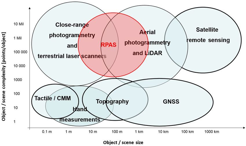
D. Giordan et al.: The use of remotely piloted aircraft systems                                                                1083

al., 2013) and combined analysis of lidar DTM and images             age correlation techniques has also been described by Lu-
(Van Den Eeckhaut et al., 2007; Haneberg et al., 2008; Gior-         cieer et al. (2014a), who demonstrated that COSI-Corr (Co-
dan et al., 2013; Razak et al., 2013; Niculiţa, 2016). The          registration of Optically Sensed Imaged and Correlation –
use of RPASs for the identification and mapping of a land-           Leprince et al., 2007, 2008; Ayoub et al., 2009) can be
slide has been described by several authors (Niethammer              adopted for the definition of the surface movement of the
et al., 2009, 2010, 2011; Rau et al., 2011; Carvajal et al.,         studied landslide. A possible alternative solution is a multi-
2011; Travelletti et al., 2012; Torrero et al., 2015; Casagli        temporal analysis of the use of DSMs. The comparison of
et al., 2017). Niethammer et al. (2009) and Liu et al. (2015)        digital surface models can be used for the definition of volu-
showed how RPASs could be considered a good solution for             metric changes caused by the evolution of the studied land-
the acquisition of ultra-high-resolution images with low-cost        slide. The acquisition of these digital models can be done
systems. Fiorucci et al. (2018) compared the results of the          with terrestrial laser scanners (Baldo et al., 2009) or airborne
landslide limitations mapped using different techniques and          lidar (Giordan et al., 2013). Westoby et al. (2012) empha-
found that satellite images can be considered a good solution        sized the advantages of RPASs concerning terrestrial laser
for the identification and mapping of landslides over large ar-      scanners, which can suffer from line-of-sight issues, and air-
eas. On the contrary, if the target of the study is the definition   borne lidar, which are often cost-prohibitive for individual
of the landslide’s morphological features, the use of more           landslide studies. Turner et al. (2015) stressed the importance
detailed RPAS images seemed to be the better solution. As            of a good co-registration of multi-temporal DSMs for good
suggested by Walter et al. (2009) and Huang et al. (2017a),          results that could decrease in accuracy. The use of bench-
one of the most critical elements for correct georeferencing         marks in areas not affected by morphological changes can
of acquired images is the use of GCPs. The in situ installa-         be used for a correct calibration of rotational and translation
tion and positioning acquisition of GCPs can be an impor-            parameters.
tant challenge, in particular in dangerous areas such as active
landslides. Very often, GCPs are not installed in the most ac-       2.1.3    Landslide susceptibility and hazard assessment
tive part of the slide but on stable areas. This solution can be
safer for the operator, but it can also reduce the accuracy of       Landslide susceptibility and hazard assessment are often per-
the final reconstruction.                                            formed at basin scale (Guzzetti et al., 2005) using different
   Another parameter that can be considered during the plan-         remote-sensing techniques (Van Westen et al., 2008). The
ning of the acquisition phase is the morphology of the studied       use of RPASs can be considered for single case study ap-
area. According to with Giordan et al. (2015b), slope mate-          plications to help decision makers in the identification of
rials and gradient can affect the flight planning and the ap-        landslide damage and the definition of residual risk (Gior-
proach used for the acquisition of the RPAS images. Two              dan et al., 2015a). Saroglou et al. (2018) presented the use
possible scenarios can be identified: (i) steep to vertical ar-      of RPASs for the definition of trajectories of rockfall-prone
eas (> 40◦ ) and (ii) slopes with gentle-to-moderate slopes          areas. Salvini et al. (2017, 2018) and Török et al. (2018) de-
(< 40◦ ). In the first case, the use of multi-copters with oblique   scribed the combined use of TLS and RPASs for hazard as-
acquisitions is often the best solution. On the contrary, with       sessment of steep rock walls. All these papers considered the
more gentle slopes, the use of fixed-wing systems can assure         use of RPASs as a valid solution for the acquisition of DSM
the acquisition of larger areas.                                     over sub-vertical areas. Török et al. (2018) and Tannant et
                                                                     al. (2017) also described in their papers how RPAS DSMs
2.1.2   Landslide monitoring                                         can be used for the evaluation of slope stability using numeri-
                                                                     cal modelling. Fan et al. (2017) analysed the geometrical fea-
The second possible field of application of RPASs is the use         tures and provided the disaster assessment of a landslide that
of multi-temporal acquisitions for landslide monitoring. This        occurred on 24 June 2017 in the village of Xinmo in Maoxian
topic has been described by several authors (Dewitte et al.,         County (Sichuan province, south-west China). Aerial images
2008; Turner and Lucieer, 2013; Travelletti et al., 2012; Lu-        were acquired the day after the event from a UAV (fixed-wing
cieer et al. 2014a; Turner et al., 2015; Marek et al., 2015;         UAV, with a weight less than 10 kg, and flight autonomy up
Lindner et al., 2016; Peppa et al., 2017). In these works,           to 4 h), and a DEM was processed, with the purpose to anal-
numerous techniques based on the multi-temporal compar-              ysed the main landslide geometrical features (front, rear edge
ison of RPAS data sets for the definition of the evolution           elevation, accumulation area, horizontal sliding distance).
of landslides have been presented and discussed. Nietham-
mer et al. (2010, 2012) described how the position change            2.2     Floods
of geomorphological features (in particular fissures) could
be considered for a multi-temporal analysis with the aim             Disastrous floods in urban, lowland areas often cause fatali-
of the characterization of the landslide evolution. Travelletti      ties and severe damage to the infrastructure. Monitoring the
et al. (2012) introduced the possibility of a semi-automatic         flood flow, assessment of the flood inundation areas and re-
image correlation to improve this approach. The use of im-           lated damages, post-flood landscape changes and pre-flood

www.nat-hazards-earth-syst-sci.net/18/1079/2018/                             Nat. Hazards Earth Syst. Sci., 18, 1079–1096, 2018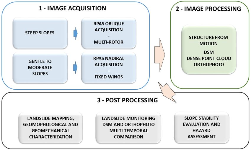
1084                                                              D. Giordan et al.: The use of remotely piloted aircraft systems

Figure 4. Acquisition, processing and post-processing of RPAS images applied to (i) landslide recognition, (ii) hazard assessment and (iii)
slope evolution monitoring.

prediction are therefore urgently required. Among various               ful for rainfall-run-off modelling for the risk assessment of
scales of approaches for flood hazards (Sohn et al., 2008),             floods by mapping detailed land-use information. As key in-
the RPASs has been adopted for each purpose of the flood                put data, high-resolution imperviousness maps were gener-
damage prevention and mitigation because it has the ability             ated for urban areas from RPAS imagery, which improved
to take quick measurements at a low cost (DeBell et al., 2016;          hydrological modelling for the flood assessment. Zazo et
Nakamura et al., 2017). Figure 5 shows an example of the use            al. (2015) and Şerban et al. (2016) demonstrated hydrologi-
of RPASs for prompt damage assessment by a severe flood                 cal calculations of potentially flood-prone areas using RPAS-
occurred on early July 2017 in the northern Kyushu area,                derived 3-D models. They utilized 2-D cross profiles derived
south-west Japan. The Geospatial Information Authority of               from the 3-D model for hydrological modelling.
Japan (GSI) utilized an RPAS for the post-flood video record-
ing and photogrammetric mapping of the damaged area with                2.2.2   Flood monitoring
flood flow and large woody debris.
                                                                        Monitoring of the ongoing flood is potentially important for
2.2.1   Potential analysis of flood inundation                          real-time evacuation planning. Le Coz et al. (2016) men-
                                                                        tioned that videos captured by an RPAS, which can be oper-
Risk assessment of flood inundation before the occurrence of            ated not only by research specialists but also by general non-
a flood is crucial for the mitigation of the flood disaster dam-        specialists, are potentially useful for quantitatively monitor-
ages. RPAS is capable of providing a quick and detailed anal-           ing floods as well as estimating flow velocity and modelling
ysis of the land surface information including topography,              floods. They can also contribute to the crowd-sourced data
land cover and land use data, which are often incorporated              collection for flood hydrology and citizen science. In the case
into hydrological models for estimating floods (Costa et al.,           of flood monitoring by image-based photogrammetry, how-
2016). As a pre-flood assessment, Li et al. (2012) explored             ever, areas under water are often problematic because the bed
the area around an earthquake-derived barrier lake using an             is not often fully seen in aerial images. If the water is clear
integrated approach of remote sensing with RPASs for hydro-             enough, bed images under water can be captured, and the bed
logical analysis of the potential dam-break flood. They pro-            morphology can be measured with additional corrections of
posed a technical framework for real-time evacuation plan-              refraction (Tamminga et al., 2015; Woodget et al., 2015), but
ning by accurately identifying the source water area of the             the floodwater is often unclear because of the abundant sus-
dammed lake using an RPAS, followed by along-river hy-                  pended sediment and disruptive flow current. Another option
drological computations of inundation potential. Tokarczyk              is the fusion of different data sets using a sonar-based mea-
et al. (2015) showed that the RPAS-derived imagery is use-              surement for the water-covered area, which is registered with

Nat. Hazards Earth Syst. Sci., 18, 1079–1096, 2018                              www.nat-hazards-earth-syst-sci.net/18/1079/2018/
D. Giordan et al.: The use of remotely piloted aircraft systems 1085
Figure 5. Image captures of a flood hazard using RPASs just after the 2017 heavy rain in northern Kyushu in early July (south-west Japan),
provided by GSI. (a) A screenshot of the aerial video of a flooded area along the Akatani River, Asakura city in Fukuoka Prefecture.
(b) Orthorectified image of the damaged area. Locations of woody debris jam are mapped and shown on the online map (GSI, 2017). The
video and map products are freely provided (compatible with Creative Commons Attribution 4.0 International).
the terrestrial data sets (Flener et al., 2013; Javernick et al., ground-based photographs. In this case, it is recommended
2014). Image-based topographic data of bottom water taken to carefully select appropriate platforms for SfM-MVS pho-
by an unmanned underwater vehicle (UUV, also known as togrammetry (either airborne or ground based) based on the
an autonomous underwater vehicle, AUV) can also be an- field conditions. Tamminga et al. (2015) examined the 3-D
other option (e.g. Pyo et al., 2015), although the application changes in river morphology due to an extreme flood event,
of UUV to flooding has been limited. revealing that the changes in reach-scale channel patterns of
As well as the use of topographic data sets derived from erosion and deposition are poorly modelled by the 2-D hy-
Structure-from-Motion – Multi-View Stereo (SfM–MVS) drodynamics based on the initial condition before the flood.
photogrammetry, the use of orthorectified images concur- They also demonstrate that the topographic condition can
rently derived from the RPAS-based aerial images is advan- be more stable after an extreme flood event. Langhammer
tageous for the assessment of hydrological observation and et al. (2017) proposed a method to quantitatively evaluate
modelling of floods. Witek et al. (2014) developed an ex- the grain size distribution using optical images taken by an
perimental system to monitor the streamflow in real time to RPAS, which is applied to the sediment structure before and
predict overbank flood inundation. The real-time prediction after a flash flood.
results are also visualized online with a web map service In a relatively long-term study, Dunford et al. (2009) and
with a high-resolution image (3 cm px−1 ). Feng et al. (2015) Hervouet et al. (2011) explored annual landscape changes af-
reported that the accurate identification of inundated areas ter the flood using RPAS-derived images together with other
is feasible using RPAS-derived images. In their case, deep- data sets such as satellite image archives or a manned motor
learning approaches of image classification using optical im- paraglider. Their work assessed the progressive development
ages and textures by RPASs successfully extracted the in- of vegetation on a braided channel at an annual scale, which
undated areas, which must be useful for flood monitoring. appears to be controlled by local climate including rainfall,
Erdelj et al. (2017) proposed a system that incorporates mul- humidity and air temperature, hydrology, groundwater level,
tiple RPAS devices with wireless sensor networks to perform topography and seed availability. Changes in the sediment
real-time assessment of a flood disaster. They discussed the characteristics due to flooding is another key feature to be
technical strategies for real-time flood disaster management examined.
including the detection, localization, segmentation and size
evaluation of flooded areas from RPAS-derived aerial im- 2.3 Earthquakes
ages.
Remote-sensing technology has been recognized as a suit-
2.2.3 Post-flood changes able source with which to provide timely data for automated
detection of damaged buildings for large areas (Dong and
Post-flood assessments of the land surface materials includ- Shan, 2013; Pham et al., 2014; Cannioto et al., 2017). In the
ing topography, sediment and vegetation are more feasi- post-event, satellite images have been traditionally used for
ble through RPAS surveys (Izumida et al., 2017). Smith et decades to visually detect damage on the buildings to priori-
al. (2014) proposed a methodological framework for the im- tize the interventions of rescuers. Operators search for exter-
mediate assessment of flood magnitude and affected land- nally visible damage evidence such as spalling, debris, rub-
forms by SfM-MVS photogrammetry using both aerial and ble piles and broken elements, which represent strong indi-
www.nat-hazards-earth-syst-sci.net/18/1079/2018/ Nat. Hazards Earth Syst. Sci., 18, 1079–1096, 20181086 D. Giordan et al.: The use of remotely piloted aircraft systems
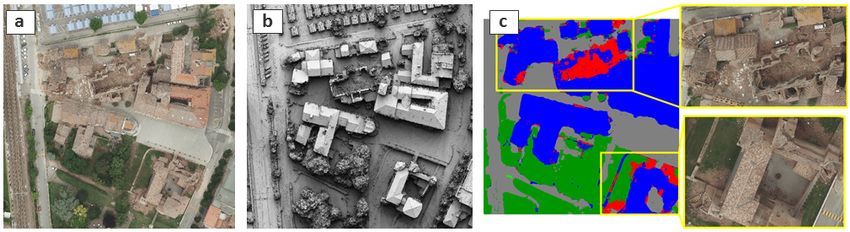
Figure 6. True orthophoto, digital surface model and damage map of an urban area using airborne nadir images (source: Nex et al., 2014).
cators of severe structural damage. Several studies, however, The operators use RPASs to fly over the area of interest
have demonstrated how this kind of data often leads to the and get information through visual assessment of the stream-
wrong findings, usually underestimating the number of the ing videos. The quality of this analysis is therefore limited to
collapsed buildings because of their reduced resolution on the ability of the operator to fly the RPAS over the area of
the ground. In this regard, airborne images and in particular interest. The lack of video georeferencing usually reduces
oblique acquisitions (Tu et al., 2017; Nex et al., 2014; Gerke the interpretability of the scene and the accurate localiza-
and Kerle, 2011; Nedjati et al., 2016) have demonstrated bet- tion of the collapsed parts: only small regions can be ac-
ter input for reliable assessments, allowing the development quired in a single flight. The lack of georeferenced maps pre-
of automated algorithms for this task (Fig. 6). The deploy- vents the smooth sharing of collected information with other
ment of photogrammetric aeroplanes on the strike area is, rescue teams, limiting the practical exploitation of these in-
however, very often unfeasible, especially when early (in the struments. RPASs are mainly used in daylight conditions as
immediate hours after the event) damage assessment for re- night-time flights are extremely dangeous, and the use of
sponse action is needed. thermal images is of limited help to the rescuers.
For this reason, RPASs have turned out to be valuable in- Many researchers have developed algorithms to automati-
struments for assessing damage to buildings (Hirose et al., cally extract damage information from imagery (Fig. 7). The
2015). The main advantages of RPASs are their availability main focus of these works is to reliably detect damage in
(and reduced cost) and the ease at which they repeatedly ac- a reduced time to satisfy the time constraints of the res-
quire high-resolution images. Thanks to their high resolution, cuers. In Vetrivel et al. (2015) the combined use of images
their use is not only limited to the early impact assessment and photogrammetric point clouds have shown promising re-
for supporting rescue operations but is also considered in the sults thanks to a supervised approach. This work, however,
preliminary analysis of the structural damage assessment. highlighted how the classifier and the designed 2-D and 3-
D features were hardly transferable to different data sets:
2.3.1 Early impact assessment each scene needed to be trained independently, strongly lim-
iting the efficiency of this approach. In this regard, the recent
The fast deployment in the field, the ease of use and the capa- developments in machine learning (i.e. convolutional neural
bility to provide real-time high-resolution information of in- networks, CNN) have overcome these limitations (Vetrivel et
accessible areas to prioritize the operator’s activities are the al., 2017), showing how they can correctly classify scenes
strongest features of RPASs (Boccardo et al., 2015). The use even if they were trained using other data sets: a trained clas-
of RPASs for rescue operations started almost a decade ago sifier can be directly used by rescuers on the acquired im-
(Bendea et al., 2008) but their massive adoption began only ages without need for further operations. The drawback of
in the last few years (earthquake in Nepal 2015) thanks to these techniques is the computational time: the use of CNN
the development of low-cost and easy-to-use platforms. Ini- processing such as image segmentation or point cloud gen-
tiatives such as UAViators (http://uaviators.org/, last access: eration is computationally demanding and hardly compatible
6 March 2018) have further increased public awareness and with real-time needs (Brostow et al., 2008). In this regard,
acceptance of this kind of instrument. Several rescue depart- most recent solutions exploit only images (i.e. no need to
ments have now introduced RPASs as part of the conven- generate point cloud) and limit the use of most expensive pro-
tional equipment of their teams (Xie et al., 2014). The huge cesses to the regions where faster classification approaches
number of videos acquired by RPASs and posted by rescuers provide uncertain results to deliver almost real-time infor-
online (i.e. on YouTube) after the 2016 Italian earthquakes mation (Duarte et al., 2017).
confirm this general trend.
Nat. Hazards Earth Syst. Sci., 18, 1079–1096, 2018 www.nat-hazards-earth-syst-sci.net/18/1079/2018/D. Giordan et al.: The use of remotely piloted aircraft systems 1087
Figure 7. Examples of damage detection on images acquired in three different scenarios: (a) Mirabello (source: Vetrivel et al., 2017),
(b) L’Aquila and (c) Lyon (source Duarte et al., 2017).
2.3.2 Building damage assessment raphy, land cover, heat, gas composition and even gravity
field (Saiki and Ohba, 2010; Deurloo et al., 2012; Astuti et
The damage evidence that can be captured from a UAV is al., 2009; Middlemiss et al., 2016). The photogrammetric ap-
not sufficient to infer the actual damage state of the building proach used to obtain topographic data is widely applied be-
as it requires additional information such as damage to in- cause RGB camera sensors are small enough to be mounted
ternal building elements (e.g. columns and beams) that can- on a small aircraft. As mentioned before, this paper consid-
not be directly defined from the images. Even though this in- ers, in particular, small RPASs. In the study of volcanoes,
formation is limited, the images can provide useful informa- larger aircraft with payloads of kilograms are also utilized to
tion about the external condition of the structure, evidencing mount other types of sensors to monitor various aspects of
anomalies and damages and providing a first important piece their dynamic activities. For this reason, in this chapter, we
of information for structural engineers. Two main types of also consider larger RPAS solutions.
investigation can be performed: (i) the use of images for the
detection of cracks or damages on the external surfaces of 2.4.1 Topographic measurements of volcanoes
the building (i.e. walls and roofs) and (ii) the use of point
clouds (generated by photogrammetric approach) to detect A long-distance flight of an RPAS enables quick and safe
structural anomalies such as tilted or deformed surfaces. In measurements of an emerging volcanic island. Tobita et
both cases, the automated processing can only support and al. (2014a) successfully performed a fixed-wing RPAS one-
ease the work of the expert, who still interprets and assesses way flight for a distance of 130 km and a total flight time
the structural integrity of the building. of 2 h and 51 min over the sea to capture aerial images of a
In Fernandez-Galarreta et al. (2015) a comprehensive newly formed volcanic island next to Nishinoshima Island
analysis of both point clouds and images was presented to (Ogasawara Islands, south-west Pacific). They performed
support the ambiguous classification of damages and their SfM-MVS photogrammetry of the aerial images taken from
use for damage score. In this paper, the use of point clouds the RPAS to generate a 2.5 m resolution DEM of the island.
was considered efficient for more serious damages (partial or The team also performed two successive measurements of
complete collapse of the building), while images were used Nishinoshima Island in the following 104 days, revealing that
to identify smaller damages such as cracks that can be used the morphological changes in the new island cover a 1600 m
as the basis for the structural engineering analysis. The use by 1400 m area (Nakano et al., 2014; Tobita et al., 2014b).
of point clouds is investigated in Baiocchi et al. (2013) and Since the volcanic activities often last for a long period,
Dominici et al. (2017): this contribution highlights how point it is also important to connect the recent volcanic morpho-
clouds from UAVs can provide very useful information to de- logical changes to those in the past. Although detailed mor-
tect asymmetries and small deformations of the structure. phological data of volcanic topography are often unavailable,
historical aerial photographs taken in the past decades can be
2.4 Volcanic activity utilized to generate topographic models at a certain resolu-
tion. Some case studies have used archival aerial photographs
RPASs are particularly advantageous when the target area of in volcanoes for periods of more than 60 years, generating
measurement is hardly accessible on the ground due to dan- DEMs with resolutions of several metres for areas of 10 km2
gers of volcanic gas or risks of eruption in volcanic areas (Gomez, 2014; Derrien et al., 2015; Gomez et al. 2015).
(Andrews, 2015). Although the equipment of RPASs can be Although these DEMs are coarser than those derived from
lost or damaged by the volcanic activities, the operator can RPASs, they can be used as supportive data sets for modern
safely stay in a remote place. Various sensors can be mounted morphological monitoring using RPASs at a higher resolu-
on an RPAS to monitor volcanic activities, including topog- tion and measurement frequency.
www.nat-hazards-earth-syst-sci.net/18/1079/2018/ Nat. Hazards Earth Syst. Sci., 18, 1079–1096, 20181088 D. Giordan et al.: The use of remotely piloted aircraft systems
2.4.2 Gas monitoring and product sampling gions of the world (McKenzie et al., 2014; Abatzoglou and
Williams, 2016). Remote-sensing technologies can be very
Caltabiano et al. (2005) proposed the architecture of an useful in monitoring such hazards (Schroeder et al., 2016).
RPAS for the direct monitoring of gas composition in vol- Several scientists in the last few years used satellites in fire
canic clouds from Mt Etna in Italy. In this system, the 2 m monitoring (Schroeder et al., 2016). More recently, RPASs
wide fixed-wing RPASs can fly autonomously up to 4000 m have been considered to be useful as well (Martinez-de Dios
altitude with a speed of 40 km h−1 . Like this system, an et al., 2011). Hinkley and Zajkowski (2011) presented the re-
RPAS with a payload of several kilograms can carry mul- sults of a collaborative partnership between NASA and the
tiple sensors to monitor different compositions of volcanic US Forest Service established for testing thermal image data
gas. McGonigle et al. (2008) used an RPAS for volcanic gas for wildfire monitoring. A small unmanned airborne system
measurements at the La Fossa crater of Mt Vulcano in Italy. served as a sensor platform. The outcome was an improved
The RPASs has a 3 kg payload and can host an ultraviolet tool for Wildland Fire Decision Support Systems. Merino et
spectrometer, an infrared spectrometer and an electrochem- al. (2012) described a system for forest fire monitoring us-
ical sensor on board. The combination of these sensors en- ing an RPAS. The system integrates the information from the
abled the estimation of fluxes of SO2 and CO2 , which are cru- fleet of different vehicles to estimate the evolution of the for-
cial for revealing the geochemical condition of erupting vol- est fire in real time. The field tests indicated that RPASs could
canoes. The monitoring of gas composition including CO2 , be very helpful in firefighting activities (e.g. monitoring). In-
SO2 , H2 S and H2 , as well as air temperature, can be used for deed, they cover the gap between the spatial scales given by
the quantification of the degassing activities and prediction satellites and those based on cameras. Wing et al. (2014) un-
of the conduit magma convection, as suggested by the tests derlined the fact that spectral and thermal sensors mounted in
at several volcanoes in Japan (Shinohara, 2013; Mori et al., RPASs may hold great promise for future remote-sensing ap-
2016) and in Costa Rica (Diaz et al., 2015). plications related to forest fires. RPASs have great potential
An RPAS can also transport a small ground-running robot to provide enhanced flexibility for positioning and repeated
(unmanned ground vehicle, UGV) to the slope head of an ac- data collection. Tang and Shao (2015) summarize various ap-
tive volcano, where the UGV takes close-range photographs proaches of remote drone sensing, surveying forests, map-
of volcanic ash on the ground surface by running down the ping canopy gaps, measuring forest canopy height, tracking
slope (Nagatani et al., 2013). Protocols for direct sampling of forest wildfires and supporting intensive forest management.
volcanic products using an RPAS have also been developed These authors underlined the usefulness of drones for wild-
(Yajima et al., 2014). fire monitoring. RPASs can repeatedly fly to record the ex-
tent of an ongoing wildfire without jeopardizing the crew’s
2.4.3 Geothermal monitoring safety. Zajkowski et al. (2015) tested different RPASs (e.g.
quadcopter, fixed-wing) for the analysis of fire activity. Mea-
In New Zealand, Harvey et al. (2016) and Nishar et al. (2016) surements included visible and long-wave infrared (LWIR)
carried out experimental studies on the regular monitoring of imagery, black carbon, air temperature, relative humidity
intense geothermal environments using a small RPAS. They and three-dimensional wind speed and direction. The authors
used thermal images taken by an infrared imaging sensor to- also described the mission’s plan in detail, including the lo-
gether with normal RGB images for photogrammetry, map- gistics of integrating RPASs into a complex operations en-
ping both the ground surface temperature with detailed to- vironment, specifications of the aircraft and their measure-
pography and land cover data. Chio and Lin (2017) further ments, execution of the missions and considerations for fu-
assessed the use of an RPAS equipped with a thermal infrared ture missions. Allison et al. (2016) provided a detailed state
sensor for the high-resolution geothermal image mapping of the art on fire detection using both manned and unmanned
in a volcanic area in Taiwan. They improved the measure- aerial platforms. This review highlighted the following chal-
ment accuracies using an on-board sensor capable of post- lenges: the need to develop robust automatic detection algo-
processed kinematic GNSS positioning. This allows accurate rithms, the integration of sensors of varying capabilities and
mapping with fewer ground control points, which are hard to modalities, the development of best practices for the use of
place on such intense geothermal fields. new sensor platforms (e.g. mini RPASs) and their safe and
effective operation in the airspace around a fire.
2.5 Wildfires
Wildfires are a phenomenon with local and global effects 3 Discussion and conclusion
(Filizzola et al., 2017). Wildfires represent a serious threat
for land managers and property owners; in the last few years, In this paper, we analysed possible applications of RPASs
this threat has significantly expanded (Peters et al., 2013). to natural hazards. The available literature on this topic has
The literature also suggests that climate change will con- strongly grown in the last few years, along with improve-
tinue to enhance potential forest fire activity in different re- ments in the diffusion of these systems. In particular, we
Nat. Hazards Earth Syst. Sci., 18, 1079–1096, 2018 www.nat-hazards-earth-syst-sci.net/18/1079/2018/D. Giordan et al.: The use of remotely piloted aircraft systems 1089
considered landslides, floods, earthquakes, volcanic activi- emergency. In this paper, authors considered not only possi-
ties and wildfires. ble results but also the time that is required for them.
RPASs can support studies on active geological processes As in many other domains, RPASs present a disrup-
and can be considered a good solution for the identification of tive technology in which, beside conventional SfM applica-
effects and damages due to several catastrophic events. One tions for 3-D reconstructions, many dedicated and advanced
of the most important elements that characterizes the use of methodologies are still in their experimental phase and will
RPASs is their flexibility, largely confirmed by the number need to be further developed in the coming years. In the fol-
of operative solutions available in the literature. The avail- lowing years, it would be desirable to witness the transfer of
able literature pointed out the necessity of the development best practices in the use of RPASs be then from the research
of dedicated methodologies that are able to take the full ad- community to government agencies (or private companies)
vantage of RPASs. In particular, typical results of Structure- involved in the prevention and reduction of impacts of nat-
from-Motion software (orthophoto and DSM) that are con- ural hazards. The scientific community should contribute to
sidered the end of standard data-processing can very often be the definition of standard methodologies that can be assumed
the starting point for dedicated procedures specifically con- by civil protection agencies for the management of emergen-
ceived for natural hazard applications. cies.
In the pre-emergency phase, one of the main advantages of
RPAS surveys is to acquire high resolution and low-cost data
to analyse and interpret environmental characteristics and po- Data availability. No data sets were used in this article.
tential triggering factors (e.g. slope, lithology, geostructure,
land use/land cover, rock anomalies and displacement). The
data can be collected with high revisit times to obtain multi- Competing interests. The authors declare that they have no conflict
temporal observations. After the characterization of hazard of interest.
potential and vulnerability, some areas can be identified by a
higher level of risk. These cases request intensive monitoring
to gain a quantitative evaluation of the potential occurrence Special issue statement. This article is part of the special issue
“The use of remotely piloted aircraft systems (RPASs) in monitor-
of an event. In this context, the use of aerial data represents a
ing applications and management of natural hazards”. It is a result
very useful complementary data source concerning the infor-
of the EGU General Assembly 2016, Vienna, Austria, 17–22 April
mation acquired through ground-based observations, in par- 2016.
ticular for dangerous areas.
During the emergency phase, high-resolution imagery is
acquired over the event site. The primary use of this data Acknowledgements. We would like to thank the editor and two
is for the assessment of the damage grade (extent, type and anonymous referees for their useful suggestions on our work.
damage grades specific to the event and eventually of its evo-
lution). They may also provide relevant information that is Edited by: Uwe Ulbrich
specific to critical infrastructure, transport systems, aid and Reviewed by: two anonymous referees
reconstruction logistics, government and community build-
ings, hazard exposure, displaced population, etc. (Ezequiel et
al., 2014). Concurrently, the availability of clear and straight-
References
forward raster and vector data, integrated with base carto-
graphic contents (transportation, surface hydrology, bound- Abatzoglou, J. T. and Williams, A. P.: Impact of anthropogenic cli-
aries, etc.) is recognized as an added value that supports mate change on wildfire across western US forests, P. Natl. Acad.
decision makers for the management of emergency opera- Sci. USA, 113, 11770–11775, 2016.
tions (Fikar et al., 2016). These applications very often need Aicardi, I., Chiabrando, F., Lingua, A., Noardo, F., Piras, M., and
prompt and reliable interventions. RPASs should, therefore, Vigna, B.: A methodology for acquisition and processing of ther-
deliver information promptly. In this regard, very few re- mal data acquired by UAVs: a test about subfluvial springs’ in-
searchers have focused on this issue: most of the reported vestigations, Geomatics, Natural Hazards and Risk., 8, 5–17,
works present (often time consuming and even manual) post- https://doi.org/10.1080/19475705.2016.1225229, 2017.
processing of the acquired data, precluding the use of their Allison, R. S., Johnston, J. M., Craig, G., and Jennings,
S.: Airborne Optical and Thermal Remote Sensing for
results from practical and real-life scenarios. Significant ef-
Wildfire Detection and Monitoring, Sensors, 16, 1310,
fort should be taken by the research community to propose
https://doi.org/10.3390/s16081310, 2016.
faster and automated approaches. In particular during emer- Andrews, C.: Pressure in the danger zone [volcanoes], Eng. Tech-
gencies, the time required for RPAS data set processing is an nol., 10, 56–61, https://doi.org/10.1049/et.2015.0720, 2015.
important element that should be carefully considered. Gior- Ardizzone, F., Fiorucci, F., Santangelo, M., Cardinali, M., Mondini,
dan et al. (2015a) presented a case study related to a landslide A. C., Rossi, M., Reichenbach, P., and Guzzetti, F.: Very-high
resolution stereoscopic satellite images for landslide mapping,
www.nat-hazards-earth-syst-sci.net/18/1079/2018/ Nat. Hazards Earth Syst. Sci., 18, 1079–1096, 20181090 D. Giordan et al.: The use of remotely piloted aircraft systems
edited by: Margottini, C., Canuti, P., Sassa, K., Landslide Sci- Carvajal, F., Agüera, F., and Pérez, M.: Surveying a landslide in a
ence and Practice, Landslide Inventory and Susceptibility and road embankment using Unmanned Aerial Vehicle photogram-
Hazard Zoning, 1, Springer, Heidelberg, Berlin, New York, 95– metry, ISPRS Arch., 38, 1–6, 2011.
101, https://doi.org/10.1007/978-3-642-31325-7_12, 2013. Casagli, N., Frodella, W., Morelli, S., Tofani, V., Ciampalini, A.,
Astuti, G., Giudice, G., Longo, D., Melita, C. D., Muscato, G., and Intrieri, E., Raspini, F., Rossi, G., Tanteri, L., and Lu, P.: Space-
Orlando, A.: An overview of the “Volcan project”: An UAS for borne, UAV and ground-based remote sensing techniques for
Exploration of volcanic environments, J. Intell. Robot. Syst., 54, landslide mapping, monitoring and early warning, Geoenviron-
471–494, 2009. mental Disasters, 4, 1–23, https://doi.org/10.1186/s40677-017-
Ayoub, F., LePrince, S., and Keene, L.: User’s Guide to Cosi-Corr: 0073-1, 2017.
Co-Registration of Optically Sensed Images and Correlation, Chang, K.-J., Chan, Y.-C., Chen, R.-F., and Hsieh, Y.-C.: Geomor-
California Institute of Technology, Pasadena, CA, USA, 38 pp., phological evolution of landslides near an active normal fault
2009. in northern Taiwan, as revealed by lidar and unmanned air-
Baiocchi, V., Dominici, D., and Mormile, M.: UAV application in craft system data, Nat. Hazards Earth Syst. Sci., 18, 709–727,
post–seismic environment”, International Archives of the Pho- https://doi.org/10.5194/nhess-18-709-2018, 2018.
togrammetry, Remote Sensing and Spatial Information Sciences, Chang-Chun, L., Zhang, G., Lei, T., and Gong, A.: Quick image-
Volume XL-1/W2, UAV-g2013, 4–6 September 2013, Rostock, processing method of UAV without control points data in earth-
Germany, 21–25, 2013. quake disaster area, T. Nonferr. Metal. Soc., 21, s523–s528,
Baldo M., Bicocchi C., Chiocchini U., Giordan D., and Lollino 2011.
G.: LIDAR monitoring of mass wasting processes: The Radico- Chio, S.-H. and Lin, C.-H.: Preliminary Study of UAS Equipped
fani landslide, Province of Siena, Central Italy, Gemorphology, with Thermal Camera for Volcanic Geothermal Monitoring in
105, 193–201, https://doi.org/10.1016/j.geomorph.2008.09.015, Taiwan, Sensors, 17, 1649, https://doi.org/10.3390/s17071649,
2009. 2017.
Benassai, G., Aucelli, P., Budillon, G., De Stefano, M., Di Luc- Chou, T. Y., Yeh, M. L., Chen, Y., and Chen, Y. H.: Disaster mon-
cio, D., Di Paola, G., Montella, R., Mucerino, L., Sica, M., and itoring and management by the unmanned aerial vehicle tech-
Pennetta, M.: Rip current evidence by hydrodynamic simula- nology, Int. Archives of Photogrammetry, Remote Sensing and
tions, bathymetric surveys and UAV observation, Nat. Hazards Spatial Information Sciences, 38, 137–142, 2010.
Earth Syst. Sci., 17, 1493–1503, https://doi.org/10.5194/nhess- Costa, D., Burlando, P., and Priadi, C.: The importance of inte-
17-1493-2017, 2017. grated solutions to flooding and water quality problems in the
Bendea, H., Boccardo, P., Dequal, S., Tondo, G., Marenchino, D., tropical megacity of Jakarta, Sustain. Cities Soc., 20, 199–209,
and Piras, M.: Low cost UAV for post-disaster assessment, Int. https://doi.org/10.1016/j.scs.2015.09.009, 2016.
Arch. Photogramm. Remote Sens. Spat. Inf. Sci., 37, 1373–1379, DeBell, L., Anderson, K., Brazier, R. E., King, N., and Jones,
2008. L.: Water resource management at catchment scales using
Boccardo, P., Chiabrando, F., Dutto, F., Tonolo, F. G., and Lingua, lightweight UAVs: current capabilities and future perspectives,
A.: UAV deployment exercise for mapping purposes: Evaluation J. Unmanned Veh. Syst., 4, 7–30, https://doi.org/10.1139/juvs-
of emergency response applications, Sensors, 15, 15717–15737, 2015-0026, 2016.
2015. Deffontaines, B., Chang, K. J., Champenois, J., Fruneau, B., Pathier,
Bolognesi, M., Farina, G., Alvisi, S., Franchini, M., Pelle- E., Hu, J. C., Lu, S. T., and Liu, Y. C.: Active interseismic shal-
grinelli, A., and Russo, P.: Measurement of surface veloc- low deformation of the Pingting terraces (Longitudinal Valley
ity in open channels using a lightweight remotely piloted air- – Eastern Taiwan) from UAV high-resolution topographic data
craft system. Geomatics, Natural Hazards and Risk, 8, 73–86, combined with InSAR time series, Geomatics, Natural Hazards
https://doi.org/10.1080/19475705.2016.1184717, 2016. and Risk, 8, 120–136, 2017.
Brardinoni, F., Slaymaker, O., and Hassan, M. A.: Landslides in- Deffontaines, B., Chang, K.-J., Champenois, J., Lin, K.-C., Lee, C.-
ventory in a rugged forested watershed: a comparison between T., Chen, R.-F., Hu, J.-C., and Magalhaes, S.: Active tectonics
air-photo and field survey data, Geomorphology, 54, 179–196, of the onshore Hengchun Fault using UAS DSM combined with
https://doi.org/10.1016/S0169-555X(02)00355-0, 2003. ALOS PS-InSAR time series (Southern Taiwan), Nat. Hazards
Brostow, G. J., Shotton, J., Fauqueur, J., and Cipolla, R.: Segmenta- Earth Syst. Sci., 18, 829–845, https://doi.org/10.5194/nhess-18-
tion and Recognition Using Structure from Motion Point Clouds. 829-2018, 2018.
Proc. 10th European Conf. on Computer Vision: Part I, 44–57, Delacourt, C., Allemand, P., Jaud, M., Grandjean, P., Deschamps,
https://doi.org/10.1007/978-3-540-88682-2_5, 2008. A., Ammann, J., Cuq, V., and Suanez, S.: DRELIO: An Un-
Caltabiano, D., Muscato, G., Orlando, A., Federico, C., Giudice, manned Helicopter for Imaging Coastal Areas. J. Coastal. Res.,
G., and Guerrieri, S.: Architecture of a UAV for volcanic gas 56, 1489–1493, 2009.
sampling, IEEE Int. C. Emerg., 1, 739–744, 2005. Derrien, A., Villeneuve, N., Peltier, A., and Beauducel, F.: Re-
Cannioto, M., D’Alessandro, A., Lo Bosco, G., Scudero, S., and trieving 65 years of volcano summit deformation from multi-
Vitale, G.: Brief communication: Vehicle routing problem and temporal structure from motion: The case of Piton de la Four-
UAV application in the post-earthquake scenario, Nat. Hazards naise (La Réunion Island), Geophys. Res. Lett., 42, 6959–6966,
Earth Syst. Sci., 17, 1939–1946, https://doi.org/10.5194/nhess- https://doi.org/10.1002/2015GL064820, 2015.
17-1939-2017, 2017. Deurloo, R., Bastos, L., and Bos, M.: On the Use of UAVs for Strap-
down Airborne Gravimetry, Springer, Berlin, Heidelberg, 255–
261, 2012.
Nat. Hazards Earth Syst. Sci., 18, 1079–1096, 2018 www.nat-hazards-earth-syst-sci.net/18/1079/2018/You can also read