Review of Environmental Factors - Westerndale Farm - Department of Water and ...
←
→
Page content transcription
If your browser does not render page correctly, please read the page content below
Review of
Environmental
Factors
Westerndale Farm

                                                               1
2020 Westerndale Review of Environmental Factors (Word).docx
This document was prepared on behalf of the biosolids receiver, by Wastewater
Treatment Operations, Water Technologies Division and remains the property of the
Water Corporation.

This document comprises information that is confidential and of commercial
significance to the biosolids receiver and the Water Corporation and for this reason
shall not be provided to a third party, duplicated, reproduced or altered in any way
without written consent of the Water Corporation. This document must be used in its
entirety and no section can be referred to or considered without reference to the
whole document. This document is specific to the site in question and is current at
the time of writing and must not be used for any other site than the one specified in
the document.

This document was prepared solely for the purpose to enable the biosolids receiver
to apply for approval from the Department of Environment and Conservation and
Department of Health for the application of biosolids on the specified site and must
not be used for any other purpose.

                                                                                       2
2020 Westerndale Review of Environmental Factors (Word).docx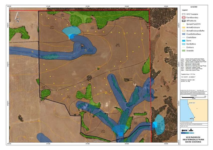
1     Table of Contents

1         Table of Contents ........................................................................................................ 3
2         Executive Summary ..................................................................................................... 5
3         Abbreviations / Definitions .............................................................................................. 6
4         Introduction ............................................................................................................... 6
5         Location ................................................................................................................... 7
6         Proposed Activity ........................................................................................................ 8
7         Site Assessment ......................................................................................................... 9
    7.1         Climate .............................................................................................................. 9
    7.2         Wind Roses ........................................................................................................ 9
    7.3         Soils ................................................................................................................. 9
    7.4         Groundwater ..................................................................................................... 12
    7.5         Salinity ............................................................................................................ 13
    7.6         Surface water .................................................................................................... 13
    7.7         Slope .............................................................................................................. 13
    7.8         Occupied Dwellings ............................................................................................. 13
    7.9         Animal Enclosures .............................................................................................. 13
    7.10        Fencing and Signage ........................................................................................... 14
    7.11        Biosolids Storage................................................................................................ 14
8         Biosolids Application Assessment .................................................................................. 14
    8.1         Contaminant Limited Biosolids Application Rate (CLBAR) ............................................... 14
    8.2         Phosphorus Limited Biosolids Application Rate (PLBAR) ................................................ 15
    8.3         Nitrogen Limited Biosolids Application Rate (NLBAR) .................................................... 15
    8.4         Paddock Applications ........................................................................................... 15
    8.5         Approximate Total Farm Application ......................................................................... 16
9         Emissions ............................................................................................................... 17
    9.1         Odour ............................................................................................................. 17
    9.2         Dust ............................................................................................................... 17
    9.3         Noise .............................................................................................................. 17
    9.4         Leachate .......................................................................................................... 18
    9.5         Stormwater runoff and surface flow .......................................................................... 18
10        Communications ....................................................................................................... 19
11        Local Government Authorities ....................................................................................... 19
12        Department of Health ................................................................................................. 19

                                                                                                                                       3
2020 Westerndale Review of Environmental Factors (Word).docx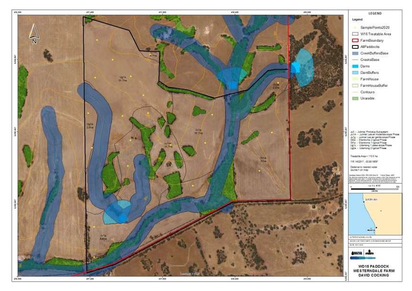
13      Health & Safety......................................................................................................... 19
14      Incident Management ................................................................................................. 20
15      Roles & Responsibilities .............................................................................................. 20
16      Record Keeping & Reporting ........................................................................................ 21
17      Conclusion .............................................................................................................. 21
18      References .............................................................................................................. 22

        Appendix A Maps ....................................................................................................................... 1
        Appendix B Biosolids Chemical Data ...................................................................................... 8
        Appendix C Background Information & Calculations ............................................................ 9

Table 1: Title Schedule – Westerndale Farm ........................................................................................................................ 7
Table 2: Westerndale Farm Paddocks .................................................................................................................................. 8
Table 3: Soils Types (Source: Geodatabase Feature Class accessed 2020) ......................................................................... 10
Table 4: Soil Sampling Chemical Analysis ........................................................................................................................... 12
Table 5: CLBAR for Cake (dry t/ha) ..................................................................................................................................... 14
Table 6: CLBAR for LAB (dry t/ha) ....................................................................................................................................... 14
Table 7: Soil MPSCCs Comparison (mg/kg) ......................................................................................................................... 15
Table 8: Phosphorus Ranking .............................................................................................................................................. 15
Table 9: NLBAR (dry t/ha) ................................................................................................................................................... 15
Table 10: Paddock Applications .......................................................................................................................................... 16
Table 11: Maximum Annual Application ............................................................................................................................. 16

                                                                                                                                                                             4
2020 Westerndale Review of Environmental Factors (Word).docx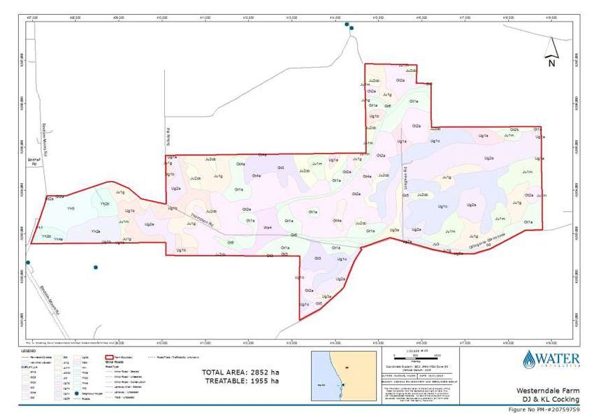
2 Executive Summary
Aroona is an alliance between the Water Corporation, SUEZ and Broadspectrum for the operation
and maintenance of Perth metropolitan water and wastewater treatment infrastructure.
Biosolids are organic residues from the treatment of domestic and industrial wastewater that has
undergone treatment to reduce pathogens and volatile organic matter, resulting in a stabilised
product suitable for beneficial use. Aroona Alliance beneficially uses 100% of biosolids produced at
Perth metropolitan wastewater treatment plants as an important carbon and nutrient source in
agricultural and composting industries.
It is proposed that biosolids from Perth metropolitan wastewater treatment plants be utilised in
direct land application at Westerndale Farm (Westerndale) in Gillingarra as a fertiliser replacement
for grain crops including canola and wheat. Westerndale is situated approximately 146 km north
east of Perth and 26km south of Moora off Thompson Road. The first application is proposed as
soon as approval is granted. This Review of Environmental Factors outlines the findings from the
assessment of the farm and its suitability for biosolids application outlining the appropriate risk
management strategies to be implemented.
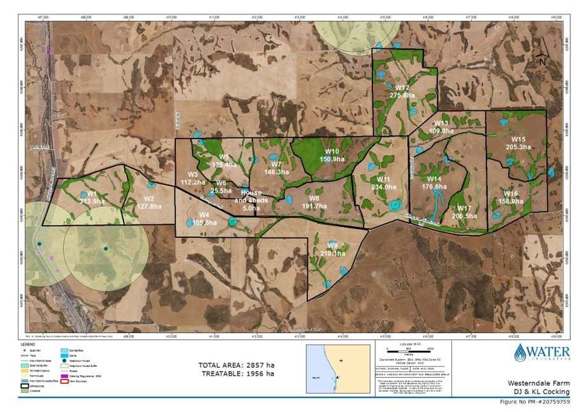
Westerndale is 2852 hectares in total with 2139 arable hectares. Buffers are required for biosolids
applications to land to reduce odour impacts and protect sensitive water resources from
contamination. Buffer distances have been applied in line with WA Guidelines for Biosolids
Management (Department of Water and Environmental Regulation, 2012) leaving approximately
1955 treatable hectares suitable for biosolids applications. Westerndale farm can therefore receive
approximately 94451 wet tonnes of biosolids cake or 139,751 wet tones of lime amended biosolids
annually.
Aroona Alliance is therefore requesting a licence for a Category 61A – Solid waste facility with a
capacity range of more than 10,000 but not more than 100,000 tonnes per annum.
Three (3) paddocks were sampled, analysed and assessed for suitability for biosolids application at
Westerndale and were found to be suitable for biosolids application at the nitrogen limited
biosolids application rate, based on the nitrogen requirements of the proposed crops.
Paddock W2 has 102.4 hectares of treatable area (arable land minus buffer areas) arable land and
can take 4947 wet tonnes of biosolids cake or 7322 wet tonnes of lime amended biosolids at
appropriate rates.
Paddock W15 has 147.9 hectares of treatable area and approximately 7145 wet tonnes of biosolids
cake or 10576 wet tonnes of lime amended biosolids can be applied to the paddock at appropriate
rates.
Paddock W16 has 107.8 hectares of treatable area which is suitable for an application of 5208 wet
tonnes of biosolids cake or 7708 wet tonnes of lime amended biosolids at appropriate rates.
5
2020 Westerndale Review of Environmental Factors (Word).docx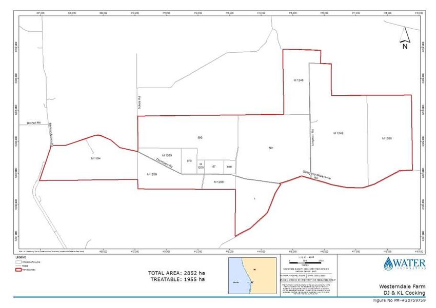
All stakeholders and the local community will be consulted prior to biosolids applications. Buffers
will be in place to both protect the amenity of neighbouring residents and the environment. All
stakeholders will be aware of their roles and responsibilities prior to biosolids applications. Aroona
Alliance (Water Corporation) will provide Department of Water and Environmental Regulation a
report on the proposed activity at the end of the licenced reporting period, preferably financial
year.

All biosolids applications will occur in line with the Biosolids Guideline unless otherwise approved
by Department of Water and Environmental Regulation, and Department of Health.

3   Abbreviations / Definitions

Biosolids Guidelines – The Western Australian Guidelines for Biosolids Management (DWER 2012)

CLBAR – Contaminant limited biosolids application rate

DPIRD – Department of Primary Industries and Regional Development

DWER – Department of Water and Environmental Regulation

DoH – Department of Health

Ha - Hectare

LAB – Lime Amended Biosolids

MPSCC – Maximum permissible soil contaminant concentration

NATA - National Association of Testing Authorities

NLBAR – Nitrogen limited biosolids application rate

PLBAR – Phosphorus limited application rate

PPE – Personal Protective Equipment

REF – Review of Environmental Factors

T/ha – Tonnes per hectare

WWTP – Wastewater treatment plant

4   Introduction

This Review of Environmental Factors (REF) for biosolids direct land application to Westerndale
farm, Victoria Plains, is prepared by Aroona Alliance on behalf of property owner and manager
David Cocking.

                                                                                                         6
2020 Westerndale Review of Environmental Factors (Word).docx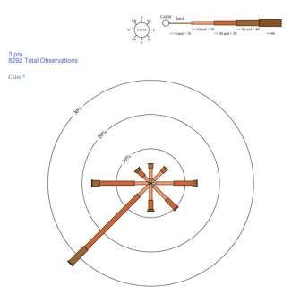
Biosolids are rich in nutrients and organic matter and are a good natural fertiliser and soil improver.
Direct land applications of biosolids in Western Australia are conducted under strict quality criteria
and have a long history of safe and effective performance. The Aroona Alliance (Water Corporation)
has long recognised the value of this renewable resource, which is well suited to the State’s
nutrient deficient soils.
This REF outlines the proposed activity, an assessment of the property for is suitability for biosolids
applications, calculations of biosolids application rates, relevant risk management processes, roles
and responsibilities, and reporting requirements. It describes the application of lime amended
biosolids (LAB) or dewatered biosolids cake to Westerndale (specifically, W2, W15 and W16
paddocks) and provides details for the Department of Water and Environment Regulation (DWER)
licence application and Department of Health (DoH) approval.
The key factors considered in the land application of LAB or biosolids cake are:
Contaminant loading;
Nutrient loading; and
Characteristics of the application site.
The suitability of this property has been assessed in accordance with the Western Australian
Guidelines for Biosolids Management (December 2012).
5 Location
Westerndale is located in the Shire of Victoria Plains approximately 12km north west of New
Norcia, 16 km north of Mogumber and 120 km North of Perth. Westerndale farm is located across
ten land parcels accessed via Thompson Road, Gillingarra (Table 1). The property consists of 18
paddocks covering 2845 hectares, with approximately 1955 hectares of treatable land (see farm
map in Appendix 1).
Table 1: Title Schedule – Westerndale Farm
Lot Diagram Volume Folio Hectares
M1184 D005049 1096 276 338ha
Lot 500 D054739 1581 815 379
M1209 D005367 1661 781 266.1
Lot 879 P249690 1661 780 40.6ha
Lot 67 P228035 2789 90 26.4ha
Lot 616 P249557 1644 476 16.2ha
Lot 501 D054739 1581 816 473ha
Lot 1 P007150 1661 778 167.4ha
Lot 1249 D005240 1732 757 762ha
M 1388 D018322 1240 430 360.8ha
Westerndale farm is divided into 18 paddocks, of which 17 are appropriate for biosolids application,
these are listed below:
7
2020 Westerndale Review of Environmental Factors (Word).docxTable 2: Westerndale Farm Paddocks
Paddock Name Unique Identifier Fenced Size (ha) Suitable for Biosolids application
W1 W1 213.9 Yes
W2 W2 127.8 Yes
W3 W3 112.2 Yes
W4 W4 155.6 Yes
W5 W5 136.4 Yes
W6 W6 25.5 Yes
W7 W7 148.3 Yes
W8 W8 191.7 Yes
W9 W9 210.1 Yes
W10 W10 150.9 Yes
W11 W11 234.0 Yes
W12 W12 275.8 No
W13 W13 109.9 Yes
W14 W14 176.6 Yes
W15 W15 205.3 Yes
W16 W16 158.9 Yes
W17 W17 206.5 Yes
House and sheds House and sheds 5.0 No
6 Proposed Activity
It is proposed that biosolids cake (Cake) from Beenyup and Woodman Point wastewater treatment
plants (WWTPs) and lime amended biosolids (LAB) from Subiaco WWTP are applied to paddocks at
Westerndale farm as a fertiliser for canola and/or wheat crops. The first application is scheduled to
occur in 2020.
Biosolids will be applied at a rate to satisfy the nitrogen requirements of each crop, unless
contamination or phosphorus retention characteristics of the soil of the paddock require a lower
application rate (see details in Biosolids Application Assessment, Section 8). Biosolids will also be
delivered and stored on paddocks at the farm and applied to the soil as per the Western Australian
Guidelines for Biosolids Management (DWER, 2012) (Biosolids Guidelines).
8
2020 Westerndale Review of Environmental Factors (Word).docx7 Site Assessment
7.1 Climate
Gillingarra has a moderate Mediterranean climate with an average rainfall of 475mm for years 1884
to 2019. Rainfall occurs predominantly from May to September (Walebing Weather Station, BoM,
2019).
7.2 Wind Roses
Average wind direction and speed is displayed below observed from Gingin Aero weather station
approximately 49 km south of Westerndale. The roses plot observations taken at 9 am and 3 pm at
the selected weather station between 1 May 1996 and 10 August 2019 (BoM, 2019).
7.3 Soils
Westerndale occurs within the Eastern Darling Range a gently undulating lateritic plateau on
granite with eastward-flowing streams for broad shallow valleys with flat valley floors. “Soils are
mainly formed on laterite (over granite), rock weathered in situ (granite), colluvium and alluvium.”
(DAFWA,2004). The farm predominately consists of loamy gravels and sandy gravels with a PBI of
47-219, Colwell P of 24–129mg/kg, likely phosphorus category 1-3, low risk of leaching.
At Westerndale Farm DAFWA soil landscape map identifies 5 dominant Soil subsystems on arable
farmland, these are:
Glentrome 1 Typical Phase (230ha)
Glentrome 2 Typical Phase (426ha)
Julimar Leaver Gentle slope Phase (210ha)
9
2020 Westerndale Review of Environmental Factors (Word).docx Udamong 1 paleo-slope Phase (243ha)
Udamong 2 typical Phase (306ha).
Application will likely be at NLBAR. A complete list of soils is displayed in Table 3 below.
Table 3: Soil Landscape Units (Source: DAFWA, 2012, Geodatabase Feature Class-soil-landscape mapping for Western Australia)
Soil Description Soil Landscape Description
Landscape Map- Soil
Map-Soil Subsystems
System
very gently to gently inclined hillslopes
Gt1a-Glentrome
and rarely hillcrests; loamy gravel, sandy
1 typical Phase
duplexes and earths and loamy earths
very gently to gently inclined generally
lower to middle hillslopes, commonly
Gt2b-Glentrome
includes some minor drainages and
2 restricted
waterlogged patches; loamy earths,
drainage Phase
shallow loams over rock, loamy duplexes,
wet soil
very gently to gently inclined generally
upper to middle hillslopes; loamy gravel,
Gt2a-Glentrome
shallow loams over rock, loamy and
2 typical Phase
sandy duplexes, loamy earths, clays,
some wet soil
stripped very gently to gently inclined
stripped, weathered plateau hillslopes and hillcrests, commonly
with undulating low hills and Gt3-Glentrome
includes small rises of rock such as
Glentrome rises; loamy earths, loams, 3 Subsystem
dolerite; loamy earths, loamy duplexes,
System loamy gravel and some clay some sandy earths and rocky
and rock; weathered granite
rock outcrops (mainly granite), gently
and migmatite
Gt4a-Glentrome inclined hillslopes and hillcrests, tend to
4 granite Phase be rounded; bare rock, loamy earths,
shallow loams over rock, stony
fans, very gently inclined hillslopes and
Gt5-Glentrome
footslopes usually lower; loamy earths,
5 Subsystem
sandy and loamy duplexes
narrow alluvial valleys; loamy earths,
Gt6-Glentrome
sandy and loamy duplexes, some clays,
6 Subsystem
often shallow
Very gently inclined hillslopes and
Yh2a- hillcrests; loamy and sandy earths, loamy
Yarawindah 2a gravel, shallow loamy gravel over
typical Phase duricrust
Dissected lateritic plateau with
rolling to undulating low hills
Yarawindah and undulating rises; loamy Very gently to gently inclined hillslopes
Yh2d-
System gravel, loamy earth, loamy with conspicuous erosion gullies; loamy
Yarawindah 2d
duplex, some rock; weathered earths and duplexes, sandy gravels,
gravel Phase
schist and some gneiss quartz gravel lag common
Fans, very gently inclined hillslopes and
Yh5-Yarawindah foot slopes usually lower; loamy gravel,
5 Subsystem loamy earths, some loamy duplexes
10
2020 Westerndale Review of Environmental Factors (Word).docxSoil Description Soil Landscape Description
Landscape Map- Soil
Map-Soil Subsystems
System
Ju1m- Julimar Gently to moderately (rarely steep)
Leaver inclined upper hillslopes; loamy gravel,
moderate slope loamy earths
Phase
Gently inclined to steep breakaway slope;
Ju2cb-Julimar
Moderately dissected areas red to brown loamy earths and duplexes,
Michibin cb
with gravelly slopes and some loamy gravel, acid duplexes and
Phase
ridges and minor rock outcrop stony
on the eastern side of the Gently inclined upper, mid and lower
Julimar
Darling Plateau over hillslopes; loamy gravel, shallow gravel
System
weathered granite and granitic Ju1g-Julimar over duricrust, some sandy and loamy
gneiss. Loamy gravel, shallow Leaver gentle earths on rock; E. wandoo and
duplexes and pale deep sand slope Phase E.marginata woodland but with some E.
common loxophleba and Acacia spp. on the
sandier topsoil areas
Valley floors with imperfectly drained
Ju3-Julimar,
yellow duplex soils and yellow and brown
Pindalup
massive earths. Yellow duplex soils and
Subsystem
yellow and brown loamy earths.
Residual plateau, very gently inclined,
Ug1b-Udamong
small portions of Ug1a; loamy gravel,
1 plateau
some shallow gravel and sandy gravels.
remnant Phase
Heath and mallee
Plateau residual, very gently to
Ug1c-Udamong moderately inclined (for sample point locations). Chemical analysis was undertaken by a NATA accredited SGS
Laboratory. The results are displayed in Table 4, below.
Table 4: Soil Sampling Chemical Analysis 0-10cm
Reporting Paddock Paddock Paddock
Analyte Name Units
Limit W2 W15 W16
% Moisture %w/w 1 3.8 11 1.2
pH (CaCl2) pH Units 0 6.8 5.4 6.4
Phosphorus, P mg/kg 10 320 480 300
Arsenic, As mg/kg 17.5 Salinity
Westerndale farm is located within the Eastern Darling range hydrozone which was assessed as
having a moderate risk of future salinity. However, due to below average rainfall since 2007, the
proportion of bores with rising groundwater levels has decreased. (DPIRD, 2019)
7.6 Surface water
Westerndale is located within the Moore river catchment and has several ephemeral tributaries
transecting it, all of which eventually terminates at the Moore River. The Moore River North is
approximately 300 metres from the western boundary of the farm. The farm currently has 25
agricultural dams and 2 freshwater soaks which provide water for agricultural activities. In line with
the Biosolids Guidelines the permanent watercourses and freshwater soaks will have a 100m buffer
and the multiple intermittent tributaries will have 50m buffers. A 100m buffer will be applied to
agricultural dam catchment areas.
Westerndale is not situated within a surface water catchment. 100 m buffer will be maintained
upslope of the dams. 50 m buffer will be maintained upslope of the drainage lines.
7.7 Slope
The average slope across the arable farm area is 3-6% is suitable with slight risk of erosion (low risk) and >6-
12% (medium risk) is suitable if soil conservation practices are used to minimise erosion, including
contour banking, minimum tillage, no rotary hoe use, sow on contour and stubble retention with
further protection provided by water body buffers (streams, lakes, dams etc.). Slopes >12% are at
high risk of erosion and biosolids will not be applied here as per the Biosolids Guidelines.
7.8 Occupied Dwellings
Westerndale is located in an agricultural land use zone limiting potential impacts to neighbouring
properties. The closest residential dwelling is approximately 445 metres south of the farm. A 1km
buffer will be applied to all adjacent occupied residential dwellings in line with the Biosolids
Guidelines requirements, further preventing impacts to surrounding dwellings.
7.9 Animal Enclosures
There is one animal enclosure at the farm: a 1600 head capacity steel framed sheep yard; this
enclosure will have a 50m buffer applied in accordance with the Biosolids Guidelines. This buffer
will also be applied to any future enclosures that the property owner may wish to erect.
13
2020 Westerndale Review of Environmental Factors (Word).docx7.10 Fencing and Signage The proposed application areas are located on private property. The paddock is fenced to restrict stock and public access. Signs indicating that biosolids is stored and applied on the property will be placed at all entrances to the premises. The sign contains information warning that biosolids may be harmful to human health, that access is to the property where biosolids are applied is restricted to authorised personnel only, and also a contact phone number for the Water Corporation. 7.11 Biosolids Storage Biosolids will be stored on flat ground with a gradient
Paddocks W2, W15 and W16 are below the Maximum Permissible Soil Contaminant Concentrations
(MPSCCs) for Arsenic, Lead, Mercury and Nickel, as shown in Table 7.
Table 7: Soil MPSCCs Comparison (mg/kg)

Contaminant                          MPSCC            Paddock W2   Paddock W15         Paddock W16
Arsenic                                   20
rates may vary slightly throughout the year due to expected changes in treatment plant
performance however this is not expected to be significant with historical application rates ranging
between 8-9 dry t/ha for Cake and 19-21 dry t/ha for LAB.

The areas to be covered with Cake or LAB and approximate wet weights to be applied are shown in
Table 10.

Table 10: Paddock Applications

                                             W2                   W15                         W16
                                           Paddock              Paddock                     Paddock
                                       CAKE        LAB      CAKE        LAB             CAKE        LAB
Dry t/ha                                 9          19        9          19               9          19
Approx. wet t/ha                        48            72      48              72         48              72
Application area (ha)                        102.4                  147.9                      110.5

Approx. wet ton total                  4947          7322    7145           10576       5339           7901

Biosolids will be applied by the farmer as per the Biosolids Guidelines. Applying biosolids at the
NLBAR will satisfy the complete nutrient requirements of the proposed crops, and therefore no
additional fertiliser will be required.
8.5    Approximate Total Farm Application

Table 11: Maximum Annual Application

                                                                                Westerndale Farm
                                                                            CAKE                 LAB
Dry t/ha                                                                      9                   19
Approx. wet t/ha                                                             48                   72
Approx. Treatable area (ha)                                                          1035
Approx. wet tonne total                                                 35,000                  15,000

The approximate total treatable area at Westerndale farm is 1955 hectares allowing a total
application of 94,451 wet tonnes of Cake or 139,791 wet tonnes of LAB. However, the annual
agricultural programme at Westerndale coupled with annual total biosolids production means that
the total biosolids capacity of the farm is unlikely to be reached within 1 year.

At present approximately 114,000 tonnes of biosolids are produced annually. Once licenced there
will be six farms in the Biosolids program with biosolids applications rotated every two months

                                                                                                              16
2020 Westerndale Review of Environmental Factors (Word).docx
between farms, therefore the maximum annual application is not expected to be reached in an
annual period but will be a contingency in the event biosolids cannot be delivered to the alternative
farms during an allocation period.
9 Emissions
9.1 Odour
As odour is impacted by pathogens it can be controlled by ensuring final biosolids meet P3
pathogen grade before taken to farm. Grade P3 is low to medium pathogen level with some
regrowth potential. Offensive odours are not generated when coupled with management controls
and a volatile solids reduction of >38%.
Prevailing winds will direct any possible and unexpected odour away from all possible sensitive
receptors within proximity to the farm.
Control: The 1km buffers to the neighbouring residents from biosolids application areas are
sufficient to minimise adverse effects. Also, biosolids are not spread during inclement weather
when odour may be increased.
The nearest residence and sensitive receptor will be buffered from biosolids application as per the
Biosolids Guidelines, with nearby residents notified prior to application of biosolids. Application of
biosolids will not occur year round but only during one to two two-month periods annually. In the
event that an odour complaint is received an investigation will occur and relevant measures will be
implemented.
LAB will be transported in sealed metal silos and Cake will be transported with trailers using
hydraulic lids and rubber seals to minimise odour emissions during transporting. The local shire will
be consulted regarding transport routes and notified one month before application of biosolids to
farm. This will minimise the impact of any residual odour on the public.
9.2 Dust
Biosolids are applied in a relatively wet state therefore dust is not generated during spreading
operations. Dust can be generated during incorporation operations during the dry summer months,
and this also causes losses of valuable topsoil. Incorporation will therefore be delayed during these
dry periods, as per the Biosolids Guidelines.
Control: Fugitive dust emissions are not considered significant as Westerndale is based within an
agricultural landscape. Incorporation of biosolids in a moist state will reduce dust emissions.
9.3 Noise
The remote location of the property and the 1km odour buffers from neighbouring residents should
be more than sufficient to negate the effects of noise on the community.
Control: The application and spreading of biosolids is not expected to generate any noise beyond
that likely to be experienced in an agricultural landscape. The Environmental Protection (Noise)
17
2020 Westerndale Review of Environmental Factors (Word).docxRegulations, 1997 will be complied with to ensure there is no noise impacts associated to the proposed activities. 9.4 Leachate Leachate may be caused by using biosolids of an inappropriate quality as a large single application to a site or through repeat applications to a site. Maximum permissible concentrations of contaminants and nutrients have been set to prevent leachate of contaminants and nutrients (Appendix 3). Control: The application rates have been calculated using the soil analyte concentrations and biosolids quality. The calculations show Zinc to be the limiting contaminant however the application rate is Nitrogen limited, thus leaching of contaminants and nutrients are not expected to occur. Prior to application of biosolids DoH approval is sought, providing specific biosolids application rates for each paddock. The process involves soil sampling, paddock assessment and the submission of a REF as per the Biosolids Guidelines. Soil samples are taken at 0-10cm for the first application and for subsequent applications 0-10cm and 15-30cm. Reapplication checks are conducted prior to the application of biosolids for individual paddocks to ensure soil contamination has not occurred as a result of previous biosolids applications thus preventing unacceptable build-up of contaminants in the soil profile. The Phosphorus retention index of the soil is calculated for each paddock prior to application. Based on the calculations Westerndale farm has low risk of phosphorus leaching due to the high Iron content of the soil. Biosolids will be stored for a maximum of 30 days with buffer distances maintained from waterways and all environmentally sensitive areas. The application and management of the biosolids will be carried out in line with the Biosolids Guidelines. 9.5 Stormwater runoff and surface flow Biosolids have the potential to enter watercourses through stormwater runoff and surface flow. This risk is managed by adhering to the buffers set out in the Biosolids Guideline. Westerndale is dissected by multiple intermittent creeks and multiple dams sporadically distributed across the farm. Control: Biosolids will be stored for a maximum of 30 days on surfaces with gradients
10 Communications

Community acceptance and cooperation is vital for the successful operation of the biosolids
program. As such, all community concerns are investigated as a matter of priority, and issues are
resolved as quickly as possible.

The neighbouring residents will be consulted in person at least one month prior to biosolids
applications. Any concerns will be addressed with operational and administrative controls.

11 Local Government Authorities

The Shire of Victoria Plains will be consulted prior to biosolids application to minimise impacting
residential areas and roads during peak travel times. The schedule of delivery will be communicated
to the shire approximately one month prior to application. The shire has previously given support
to the biosolids program and has provided the preferred transport route to Gillingarra.

12 Department of Health

Biosolids are regulated by state health legislation and a Memorandum of understanding (MoU)
between the Water Corporation and the Department of Health. Prior to application of biosolids
DoH approval is sought, providing specific biosolids application rates for each paddock. The process
involves soil sampling, paddock assessment and the submission of a REF as per the Biosolids
Guidelines. Further details of this process are available on request.

13 Health & Safety

Biosolids are included in the MoU for Wastewater Services and Groundwater Replenishment
between the Water Corporation and DoH. The MoU is designed to establish and maintain a strong
cooperative relationship between the Water Corporation and DoH for protecting public health
associated to wastewater services. This ensures services meet health, environmental and social
expectations. Under Section 10 and Binding Protocol 1 of the MoU, the Water Corporation is
obliged to manage biosolids quality as per the Biosolids Guidelines.

Aroona Alliance (Water Corporation) ensures biosolids products are treated to a suitable grade fit
for purpose and a designated end use. All biosolids require ongoing monitoring, sampling and
analysis as per the Biosolids Guidelines and are classified according to contaminant grade (C1-3)
and pathogen grade (P1-4). Only biosolids graded as P3C2 or higher will be applied to the
Westerndale ensuring pathogen and contaminant levels are acceptable for direct land application
to minimise potential health and food safety risks.

Transport and farm operators involved in the land application program are educated about the
potential health risks from contact with biosolids. All operators will wear appropriate personal
protective equipment (PPE) and follow proper hygiene procedures. Transport operators will also
ensure that trailers are cleaned by high pressure hose after tipping to ensure that no biosolids are
transferred onto public roads.

                                                                                                    19
2020 Westerndale Review of Environmental Factors (Word).docx
Animal withholding periods will be in place as described in the Biosolids Guidelines to ensure that
no biosolids is consumed during grazing. This risk of flystrike will also be managed by using storage
limits as outlined in the Biosolids Guidelines.
The risk of fly strikes and plagues from biosolids is minimal, due to the management and timing of
operations. Limiting the time of stockpiling biosolids cake to 7 days interrupts and inhibits the cycle
of fly breeding. LAB has found to be poor at vector attraction and is not a suitable environment for
fly breeding, therefore sampling for potential fly breeding will be carried out intermittently when
LAB is applied at the Farm
14 Incident Management
Aroona Alliance and Water Corporation have incident management procedures that are to be
followed in the event of an unforeseeable incident, to ensure road traffic accidents, spills, and
other emergencies are promptly addressed, reported and spills are remediated. Biosolids transport
providers are required to have emergency spill plans in place, and operators will carry spill clean-up
equipment in their vehicles.
Community concerns and complaints will be investigated, resolved, tracked and reported as per
usual in the biosolids program using the Water Corporation’s complaints management system and
Aroona Alliance’s biosolids incident register.
Complaints will be reported to DWER and DoH as soon as practicable, and will be typically resolved
with the complainant within a week.
15 Roles & Responsibilities
The property owner and employees are responsible for:
Compliance with Biosolids Guidelines, licences, and approvals;
Ensuring awareness of licence and approvals conditions among operators;
Paddock selection;
Biosolids spreading and incorporation;
On-site incident response;
On-site record keeping; and
Providing a safe working environment.
Aroona Alliance (Water Corporation) is responsible for:
Biosolids quality control;
Licencing and approvals application processes;
Consultation with stakeholders and the community;
Coordination and provision of transport;
Off-site incident response (in consultation with the transport provider);
Complaints management and reporting;
Provision of transport logbook; and
Annual and incident reporting.
20
2020 Westerndale Review of Environmental Factors (Word).docxDWER is responsible for:
Property licencing.
DoH is responsible for:
Paddock approvals.
The Shire of Victoria Plains is responsible for:
Provision of transport route; and
Transport approvals.
16 Record Keeping & Reporting
Aroona Alliance will monitor and log all biosolids deliveries to Westerndale. The electronic logbook
will document quantity and quality of biosolids delivered as well as application rates, dates,
location, depth of incorporation and unique paddock identifiers. The logbooks will be available to
the property owner on request as well incorporated in quarterly reports provided to the property
owner.
Aroona Alliance will submit an Annual Environmental Report and Annual Audit of Compliance
Report for the reporting period on behalf of Licensee as per DWER Part V Environmental Licence
requirements, and will provide information for an annual report (by financial year) submitted to
DoH by Water Corporation to cover Farmer DoH paddock approval requirements.
17 Conclusion
All biosolids applications to Westerndale farm will be undertaken as per the Biosolids Guidelines
unless otherwise approved by DWER and DoH.
With appropriate risk management strategies in place, the application of biosolids to Westerndale
farm can safely and effectively provide complete nutrition to wheat and canola crops. If no issues
are experienced during the planned 2020 application, biosolids applications to Westerndale will
continue on an annual basis.
21
2020 Westerndale Review of Environmental Factors (Word).docx18 References
Bureau of Meteorology (BOM). 2020. Climate statistics for Australian locations.
http://www.bom.gov.au/climate/averages/tables/cw_008151.shtml (accessed 16/01/2020).
Department of Agriculture and Food (DAFWA). 2012. ArcView shapefile (spatial data), soil-
landscape mapping for Western Australia Data.
Department of Primary Industries (DPIRD). 2019, Groundwater trends in agricultural areas of
Western Australia, Department of Primary Industries (DPIRD), accessed 10/02/20
Department of Water and Environmental Regulation (DWER). 2012. Western Australian Guidelines
for Biosolids Management.
Department of Water and Environmental Regulation (DWER). 2020. http://maps.water.wa.gov.au
Geoscience Australia. 2018. Hydrography. (accessed 16/01/2020).
Tille, P. Moore, G. and Griffin, T. (1998). Soils and landscapes of South-Western Australia In
‘Soilguide. A handbook for understanding and managing agricultural soils’. (ed. G.Moore),
Department of Agriculture, Western Australia. Bulletin No. 4343, pg.38.
22
2020 Westerndale Review of Environmental Factors (Word).docxAppendix A Maps
A.1 Location Map
1
2020 Westerndale Review of Environmental Factors (Word).docxA.2 Lot Map
2
2020 Westerndale Review of Environmental Factors (Word).docxA.3 Farm Map
3
2020 Westerndale Review of Environmental Factors (Word).docxA.4 Soil Landscape Map Units
4
2020 Westerndale Review of Environmental Factors (Word).docxA.5 Paddock Map 2
5
2020 Westerndale Review of Environmental Factors (Word).docxA.6 Paddock Map- W15
6
2020 Westerndale Review of Environmental Factors (Word).docxA.7 Paddock Map W16
7
2020 Westerndale Review of Environmental Factors (Word).docxAppendix B Biosolids Chemical Data
TABLE B 1:Average biosolids chemistry (2018/19)
pH Lime Total solids TKN Ammonia N Oxidised N TP
Biosolids type pH
Equivalence (%) (%) (mg/kg) (mg/kg) (mg/kg)
(3 hour) (mg/kg)
Woodman Pt Cake 8.2 N/A N/A 18.40% 72077 7885 1.5 20230
Beenyup Cake 8.2 N/A N/A 18.20% 75500 6342 1.8 14833
Subiaco LAB 12.6 12.4 21 26.80% 50769 1471 8.3 11631
Arsenic Cadmium Chromium VI Lead Mercury Nickel Copper Zinc Chlordane Dieldrin
Biosolids type
(mg/kg) (mg/kg) (mg/kg) (mg/kg) (mg/kg) (mg/kg) (mg/kg) (mg/kg) (mg/kg) (mg/kg)
Woodman Pt Cake 4.3 1.2 0.25 29 1.3 41 662 3476* 0.01 0.01
Beenyup Cake 4 1.14 0.25 19 0.1 20 630 826 0.01 0.01
Subiaco LAB 3 0.66 0.25 7 0.7 8 392 290 0.01 0.01
* Woodman Point Zinc is the annual average as reported in the DoH Annual Sludge and Biosolids Report (2018/19) and includes the ongoing zinc incident
(INC-055972). Incident details available upon request. Blue Text = ½ LOD
8
2020 Westerndale Review of Environmental Factors (Word).docxAppendix C Background Information & Calculations
Calculation of Maximum Permissible Concentration (MPC)
The objective of the Contaminant Grading is to avoid using biosolids in a
manner that would risk excessive uptake of metals by crops or ingestion by
humans or animals or deleterious effects on the environment. These
outcomes could result from either using biosolids of an inappropriate
quality as a large single application to a site or through repeat applications
to a site. Maximum permissible concentrations (MPCs) have been set for
some contaminants in soils used for the production of food crops (refer to
Table A4) and can be calculated for others (refer Equations X, Y and Z).
Critical soil concentrations of metal contaminants can adversely affect
microbial processes and plant productivity (ie Cu, Zn) or exceed levels
permitted by food standards for human consumption (ie Cd). These critical
values are affected by soil properties such as pH, clay content, organic
carbon content and cation exchange capacity.
Table A4. Maximum Permissible Concentrations (MPCs)
Contaminant Soils (mg/kg dry weight)
Arsenic 20
Chromium IV 1
Lead 200
Mercury 1
Nickel 60
Selenium 3
Chlordane 0.02
Dieldrin 0.02
Zinc 300
Equation - Table A10 - Calculation of site specific MPC for Cadmium
(Note: background usually minimal thus not related to background conc)
MPC (Cd) = critical soil Cd concentration x biosolids availability factor
where:
critical soil Cd concentration = 0.067 x soil pH + 0.015 x clay content
-0.12 biosolids availability factor = 2.1
9
2020 Westerndale Review of Environmental Factors (Word).docxEquation - Table A8 - Calculation of site specific MPC for Copper
(Note: Copper and Zinc based on amount added)
MPC (Cu) = Actual Cu ACL x Cu BAF + actual soil [Cu]
where:
Actual Cu ACL = the lowest result from the Cu ACL for plants, Cu ACL
for SIN and Cu ACL for SIR
Cu ACL for plants = 35.34 x (actual OC%/standard soil OC%) x
(actual [H+]/standard soil [H+])^-0.309
where:
actual OC% = Organic carbon content and is specified by
applicant
standard soil OC% = 1%
actual [H+] = 1 x 10-pH, where the pH is
specified by the applicant
standard soil [H+] = 1 x 10⁻⁶
ACL = added contaminant limit
Cu ACL for SIN = 633 log CEC + 223 pH -1458
where:
CEC = Cation exchange capacity and is specified by the
applicant pH is specified by the applicant
Cu ACL for SIR = 115mg
Cu BAF = 0.7504 e 0.131 x soil pH
where:
Cu BAF = biosolids availability factor for Cu
pH is specified by the applicant
actual soil [Cu] = ambient background concentration and
is specified by the applicant
10
2020 Westerndale Review of Environmental Factors (Word).docxEquation - Table A9 - Calculation of site specific MPC for Zinc
MPC (Zn) = Actual Zn ACL x Zn BAF + actual soil [Zn]
where
Actual Zn ACL = the lowest result from the Zn ACL for plants, Zn ACL
for SIN and Zn ACL for SIR
Zn ACL for plants = 119.93 x (actual CEC/standard soil
CEC)^0.702 x actual [H+]/standard[H+]^-0.271
where:
actual CEC is Cation exchange capacity and is specified
by the applicant standard soil CEC = 10
actual [H+] = 1 x 10-pH, where the pH is specified by
the applicant standard soil [H+] = 1 x 10⁻⁶
ACL = added contaminant limit
Zn ACL for SIN = 0.55 pH-0.55
where:
pH is specified by the applicant
Zn ACL for SIR = 300mg
Zn BAF = 1
actual soil [Zn] = ambient background concentration and is
specified by the applicant.
Maximum Permissible Annual Contaminant Load
In addition to the MPC, a Maximum Permissible Annual Contaminant Load
(MPACL) has been set for Cadmium (ref Tb A6).
Table A6. Limiting amounts of contaminants that can be annually applied to soils (maximum
permissible annual contaminant load)
Contaminant Limiting value (kg/ha per year)
0.03
Limiting value (kg/ha per 5
Cadmium
years)
0.15
11
2020 Westerndale Review of Environmental Factors (Word).docxCalculation of CLBAR
To calculate the CLBAR, the following information is required:
results of analysis of receiving soil (refer to App 2, table A3)
(Measured Soil Contaminant Concentration, MSCC) (mg/kg)
results of analysis of biosolids (refer to Appendix 2, table A1)
(Biosolids Contaminant Concentration, BCC) (mg/kg)
maximum permissible annual cadmium load (refer to Appendix 5,
Table A6) (MPACL) (kg/ha/yr)
maximum permissible soil concentration (refer table A4, grade C1
and calculated values) (MPC) (mg/kg)
The CLBAR needs to be calculated for each contaminant using the following
equation:
Calculation of CLBAR - all metals
CLBAR = (MSCC-MPC) x SM)/(BCC x TS)
where:
MSCC = Measured Soil Contaminant Concentration (mg/kg)
MPC = Maximum Permissible Soil Concentration (mg/kg) and is
sourced from the guideline or calculated earlier
SM = incorporated soil mass per hectare (dry tonnes/ha) based on:
(Soil bulk density (dry tonnes/m3) /1000) x (Incorporation
depth (mm) x 10000)
BCC = Biosolids Contaminant Concentration (mg/kg)
In addition, a second CLBAR for Cadmium needs to be calculated based on
the MPACL using the following equation:
Calculation of CLBAR – Cadmium
CLBAR = (MPACL x 1000000)/(BCC x 1000 x TS)
where:
CLBAR is Contaminant Limiting Biosolids Application Rate
MPACL is the Maximum Permissible annual contaminant load and
equals 0.03 kg/ha/ye or 0.15 kg/ha/5 years
1000000mg/kg (factor to covert kg Cd to mg Cd)
BCC is the biosolids contaminant concentration and is specified by
the applicant
1000kg/t (factor to covert kg biosolids to tonnes biosolids)
TS = Total Solids (%) and is specified by applicant
The lowest value of the two is the CLBAR for cadmium.
12
2020 Westerndale Review of Environmental Factors (Word).docxNote: for equation the MPACL will decrease in future years accounting for
the amount added each year. To calculate the amount added each year,
use the following equation:
Equation - Calculation of accumulated Cd added
Cd added = (Biosolids added x BCC x1000 x TS)/1000000
where:
Biosolids added (t/ha) is the amount of biosolids actually applied
BCC is the biosolids contaminant concentration and is specified by
the applicant
1000kg/t (factor to covert kg biosolids to tonnes)
TS = Total Solids (%) and is specified by applicant
1000000mg/kg (factor to covert mg Cd to kg Cd)
Calculation of NLBAR
To calculate the NLBAR, the following information is required:
crop nutrient requirement (CNR) (kg/ha) (seek advice on these)
results of analysis of biosolids (BCC)
available biosolids nutrient (ABN) (kg/t)
biosolids type
Equation - Calculation of NLBAR - nitrogen
NLBAR (t/ha) = CNR (kg/ha) / ABN (kg/t)
where:
ABN (year 1) = ((ammonium N + oxidised N + (organic N x MR)) x
1000/1000000
where:
N = TKN - ammonium N (mg/kg)
Oxidised N = N as nitrite and nitrate (mg/kg)
TKN = total kjeldahl nitrogen (mg/kg)
MR = minerlisation rate (%)
1000kg/t (factor to covert kg to t)
1000000mg/kg (factor to covert mg to kg)
The mineralisation rate for organic nitrogen is included as organic nitrogen
is not immediately available and may be released over a number of years.
The rate of release is dependent on the biosolids treatment process as
shown in Table A13. When frequent applications of biosolids are intended,
the residual organic nitrogen in the soil from previous applications will need
to be considered for its future contribution to “available soil nitrogen”.
13
2020 Westerndale Review of Environmental Factors (Word).docxTable A13. Calculating Biosolids Mineralisation Rate
Nitrogen Mineralisation
Biosolids type Rate
Anaerobic digestion 15%
Aerobic digestion 25%
Lime Amended Biosolids 10%
Calculation of PLBAR
Table 9. Soil Ranking System Based on PRI
Agronomic Risk of P Leaching
Bicarbonated extractable Demand for given reactive Fe
PRI P (Colwell, mg P/kg) P >200mg/kg Category
70
>15 Moderate Negligible 1
25 Low Low 3
20 Low Low 3You can also read