Reviews and syntheses: How do abiotic and biotic processes respond to climatic variations in the Nam Co catchment (Tibetan Plateau)? - Biogeosciences
←
→
Page content transcription
If your browser does not render page correctly, please read the page content below
Biogeosciences, 17, 1261–1279, 2020
https://doi.org/10.5194/bg-17-1261-2020
© Author(s) 2020. This work is distributed under
the Creative Commons Attribution 4.0 License.

Reviews and syntheses: How do abiotic and biotic processes respond
to climatic variations in the Nam Co catchment (Tibetan Plateau)?
Sten Anslan1,2 , Mina Azizi Rad2,3 , Johannes Buckel4 , Paula Echeverria Galindo2 , Jinlei Kai5,6 , Wengang Kang2 ,
Laura Keys7 , Philipp Maurischat8 , Felix Nieberding2,9 , Eike Reinosch10 , Handuo Tang5,6 , Tuong Vi Tran11 ,
Yuyang Wang5,6 , and Antje Schwalb2
1 Zoological   Institute, Technische Universität Braunschweig, Mendelssohnstr. 4, 38106 Braunschweig, Germany
2 Institute of Geosystems and Bioindication, Technische Universität Braunschweig,
Langer Kamp 19C, 38106 Braunschweig, Germany
3 Max Planck Institute for Biogeochemistry, 07745 Jena, Germany
4 Institute for Geophysics and Extraterrestrial Physics, Technische Universität Braunschweig,

Mendelssohnstraße 3, 38106 Braunschweig, Germany
5 Key Laboratory of Tibetan Environment Changes and Land Surface Processes, Institute of Tibetan Plateau Research,

Chinese Academy of Sciences, Beijing, China
6 University of Chinese Academy of Sciences, Beijing, China
7 Institute for Geography, Friedrich-Schiller-Universität Jena, Löbdergraben 32, 07743 Jena, Germany
8 Institute of Soil Science, Leibniz Universität Hannover, Herrenhäuser Str. 2, 30419 Hanover, Germany
9 GFZ German Research Centre for Geosciences, Telegrafenberg, 14473 Potsdam, Germany
10 Institute of Geodesy and Photogrammetry, Technische Universität Braunschweig,

Bienroder Weg 81, 38106 Braunschweig, Germany
11 Institute of Fluid Mechanics and Environmental Physics in Civil Engineering, Leibniz Universität Hannover,

Appelstraße 9A, 30167 Hanover, Germany

Correspondence: Felix Nieberding (f.nieberding@tu-braunschweig.de)

Received: 5 February 2019 – Discussion started: 20 March 2019
Revised: 5 February 2020 – Accepted: 6 February 2020 – Published: 6 March 2020

Abstract. The Tibetan Plateau (TP) is the largest alpine           ever-increasing deglaciation and thus higher water availabil-
plateau on Earth and plays an important role in global climate     ity have persisted over the last few decades. Increasing water
dynamics. On the TP, climate change is happening particu-          availability causes translocation of sediments, nutrients and
larly fast, with an increase in air temperature twice the global   dissolved organic matter to the lake, as well as higher car-
average. The particular sensitivity of this high mountain envi-    bon emissions to the atmosphere. The intensity of grazing
ronment allows observation and tracking of abiotic and biotic      has an additional and significant effect on CO2 fluxes, with
feedback mechanisms. Closed lake systems, such as Nam Co           moderate grazing enhancing belowground allocation of car-
on the central TP, represent important natural laboratories for    bon while adversely affecting the C sink potential through
tracking past and recent climatic changes, as well as geo-         reduction of above-surface and subsurface biomass at higher
biological processes and interactions within their respective      grazing intensities. Furthermore, increasing pressure from
catchments. This review gives an interdisciplinary overview        human activities and livestock grazing are enhancing grass-
of past and modern environmental changes using Nam Co              land degradation processes, thus shaping biodiversity pat-
as a case study. In the catchment area, ongoing rise in air        terns in the lake and catchment. The environmental signal
temperature forces glaciers to melt, contributing to a rise in     provided by taxon-specific analysis (e.g., diatoms and ostra-
lake level and changes in water chemistry. Some studies base       cods) in Nam Co revealed profound climatic fluctuations be-
their conclusions on inconsistent glacier inventories, but an      tween warmer–cooler and wetter–drier periods since the late

Published by Copernicus Publications on behalf of the European Geosciences Union.
1262                                                                      S. Anslan et al.: Processes in the Nam Co catchment

Pleistocene and an increasing input of freshwater and nutri-       ratory, which could be used as an early warning system for
ents from the catchment in recent years. Based on the re-          other alpine environments. Many lakes on the TP are superfi-
viewed literature, we outline perspectives to further under-       cially closed systems, which is why they are particularly suit-
stand the effects of global warming on geodiversity and bio-       able as “thermometers” and “rain gauges” to measure the cli-
diversity and their interplay at Nam Co, which acts as a case      matic, hydrological, geomorphological, pedological and eco-
study for potentially TP-level or even worldwide processes         logical changes in their respective catchments. With an area
that are currently shaping high mountain areas.                    of 2018 km2 , Nam Co is the second largest lake on the central
                                                                   TP. Currently, Nam Co represents an endorheic system, act-
                                                                   ing as a sink for water, sediment and carbon fluxes. The exis-
                                                                   tence of a former drainage (“Old Qiangtang Lake”) towards
1   Introduction                                                   northwestern Siling Co and further east down from the TP is
                                                                   still under discussion (Li et al., 1981; Kong et al., 2011) (see
The Tibetan Plateau (TP), often referred to as “The Third          Sect. 3.1). With good accessibility and infrastructure such
Pole” and “The Water Tower of East Asia”, is the high-             as the Nam Co Monitoring and Research Station for Multi-
est and largest alpine plateau on Earth (Qiu, 2008). With          sphere Interactions (NAMORS), the Nam Co catchment has
an area of about 2.5 million km2 at an average altitude            become a frequent study location for monitoring and tracking
of > 4000 m above sea level (a.s.l.), it includes the entire       of environmental changes over various timescales.
southwestern Chinese provinces of Tibet and Qinghai; parts            Here we present an interdisciplinary overview of how
of Gansu, Yunnan, and Sichuan; and neighboring countries           Earth surface fluxes have developed with changing environ-
(Fig. 1). The southern and eastern plateau and the adjacent        mental conditions and which consequences are to be ex-
Himalayas regions form the headwaters of several major             pected for biodiversity, as well as for water, sediment and
rivers (i.e., Brahmaputra, Ganges, Hexi, Indus, Mekong, Sal-       carbon fluxes within the study area of the Nam Co catchment
ween, Yangtze, and Yellow rivers), providing freshwater for        on the central TP. In particular, this review considers past
∼ 1.65 billion people and many ecosystems in greater Asia          and modern geobiodiversity changes with a focus on glacier
(Cuo and Zhang, 2017). Large proportions of the inner TP are       retreat in relation to hydrological patterns and changes in
endorheic and therefore do not drain into the large river sys-     lake water chemistry. The corresponding changes in terres-
tems. On the TP, the effects of climate change are expressed       trial ecosystems concerning carbon cycle, greenhouse gas
more strongly than the global average, showing a steep rise in     releases and pasture degradation are discussed. We provide
air temperature of about 0.3 ◦ C per decade since 1960 (Yao et     an overview of how the paleoenvironment on the Tibetan
al., 2007) and a moderate rise in precipitation during the last    Plateau with respect to landscape evolution around Nam Co
few decades (Dong et al., 2018). The warming rate increases        was shaped by geodiversity, lake level changes and Holocene
with altitude (Pepin et al., 2015), which is why the air tem-      vegetation cover. Lastly, based on the available studies, this
perature on the TP is soaring roughly twice the global aver-       review identifies the major research gaps that are awaiting
age, thus substantially affecting the geodiversity and biodi-      further exploration and comparison with other high-altitude
versity. Glaciers and lakes are the dominant components for        environments.
the Tibetan water sources, and their actual status and future
development are strongly impacted by global warming. Since
the 1990s, nearly all glaciers on the TP have exhibited retreat,   2     Environmental changes in Nam Co and its catchment
causing a 5.5 % increase in river runoff from the Tibetan
Plateau (Yao et al., 2007). The consequences of deglaciation       2.1    Climatic characteristics of the Nam Co basin
and permafrost degradation (Wu et al., 2010) are observable
in higher water and sediment fluxes, relief changes and aris-      The prevailing climate at Nam Co is characterized by strong
ing natural hazards (floods, rockfalls, landslides, desertifica-   seasonality, with long, cold winters and short but moist sum-
tion, ecosystem degradation). Consequently, landscapes are         mers. During winter, the westerlies control the general cir-
continuously being rearranged which alters the spatial dis-        culation and lead to cold and dry weather, with daily tem-
tribution and composition of the inhabiting species, many of       perature minima below −20 ◦ C. In springtime, the TP heats
which are endemic to the TP (Walther et al., 2002). Even con-      up and allows the meltwater to percolate to deeper soil lay-
servative estimates predict substantial species extinction and     ers. The drought situation increases gradually until the mon-
considerable changes to the ecosystems (Chen et al., 2011;         soon rains arrive, typically between May and June. During
Bellard et al., 2012). The future trajectory of such complex       autumn, weather shifts again to clear, cold and dry condi-
processes is difficult to map accurately, thus it is important     tions (Yao et al., 2013). The mean annual temperature mea-
to monitor the current state as well as the evolution of this      sured at the NAMORS research station (Fig. 1) between 2006
highly sensitive region. The large number of water bodies          and 2017 was −0.6 ◦ C, and the annual precipitation was be-
on the TP and its geological diversity, climatic setting and       tween 291–568 mm (mean = 406 mm), with the majority oc-
sensitivity to climate change make it a unique natural labo-       curring during the monsoon season from May to October

Biogeosciences, 17, 1261–1279, 2020                                                     www.biogeosciences.net/17/1261/2020/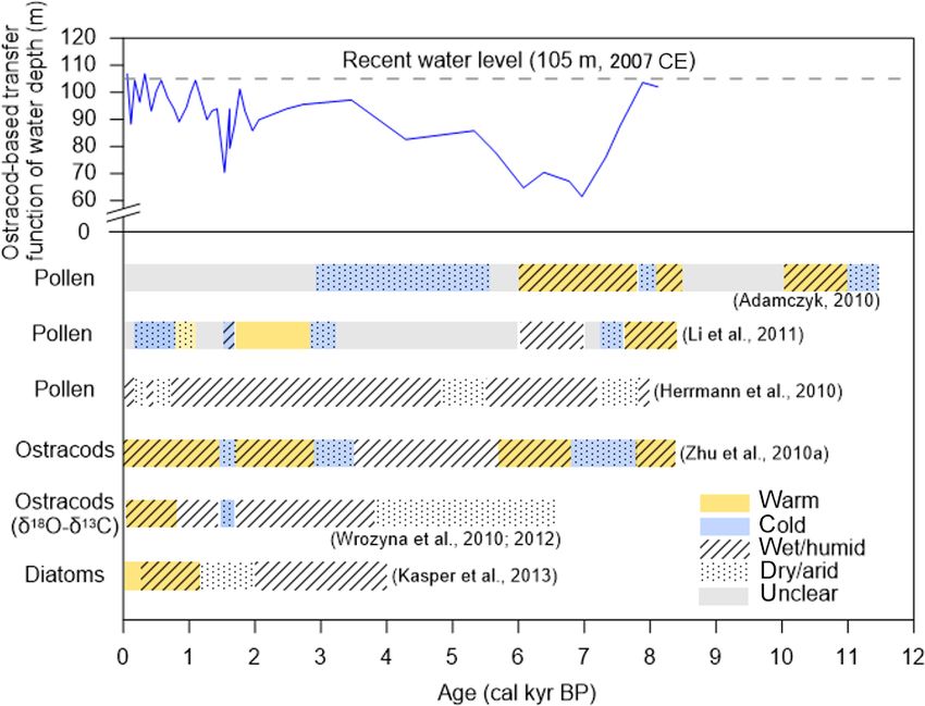
S. Anslan et al.: Processes in the Nam Co catchment                                                                                          1263

Figure 1. Major atmospheric systems governing the climate in China (a). The Nam Co study site (b). Characteristics of Nam Co’s catch-
ment (c). (a) Continuous arrows indicate systems active in summer. These are the Indian Summer Monsoon (ISM) in red, the East Asian
Summer Monsoon (EASM) in orange and the westerlies in blue. Dashed arrows represent systems active in winter. These are the Asian Win-
ter Monsoon (AWM) in green and southern parts of the westerlies in blue. The dotted black lines denote the Summer Monsoon Transition
Zone (SMTZ) (following Wünnemann et al., 2018). Background elevation data according to SRTM digital elevation model v4 (Jarvis et al.,
2008). (b) Nam Co catchment, including the current lake extent (based on Copernicus Sentinel data 2018, processed by ESA), its bathymetric
depth in 2007 (Wang et al., 2009a), the outline of the catchment (following Keil et al., 2010), glaciers of the Nyainqêntanglha Range (GLIMS
and NSDIC 2005, updated 2018) and rivers discharging into Nam Co (SRTM digital elevation model v4; Jarvis et al., 2008). The dotted red
line indicates the profile position of Fig. 2. (c) Characteristics of Nam Co: lake elevation (Jiang et al., 2017), lake surface area (Zhang et al.,
2017), catchment area, lake pH and salinity (Keil et al., 2010).

(Table 1). The onset and strength of monsoonal precipita-                   2.2   Glacier retreat and hydrological patterns of Nam
tion varies substantially between individual years and can be                     Co
delayed by up to 6 weeks, depending on the altitude and lat-
itude on the TP (Miehe et al., 2019). Precipitation rates are
                                                                            The rise of satellites such as Envisat, CryoSat, and ICESat
subject to spatial variations due to the > 7000 m high Nyain-
                                                                            and the increasingly widespread availability of their data has
qêntanglha range, which represents the southern border of
                                                                            enabled the accurate study of lake and glacier parameters as
the lake catchment. This leads to considerably larger glacial
                                                                            far back as the early 1970s (Wu and Zhu, 2008; Zhu et al.,
areas in the southwestern area (∼ 700 km2 ) than in the north-
                                                                            2010b; Liao et al., 2013). The size of Nam Co and the ex-
eastern area of the mountain range (∼ 100 km2 ) (Bolch et
                                                                            tent and distribution of glaciers in the Nyainqêntanglha range
al., 2010).
                                                                            have been the subject of many publications over the recent

www.biogeosciences.net/17/1261/2020/                                                                  Biogeosciences, 17, 1261–1279, 2020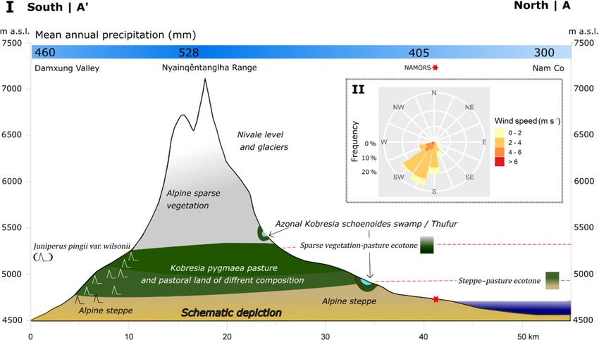
1264                                                                          S. Anslan et al.: Processes in the Nam Co catchment

Table 1. Average daily air temperature (maximum, mean and minimum in ◦ C) and average daily precipitation (sum in mm) from NAMORS
from 2006 to 2017. Calculations were performed using the tidyverse package family in R on RStudio environment (Wickham, 2017; RStudio
Team, 2018; R Core Team, 2019). Data provided by ITP Beijing; for details about sensor equipment, see Ma et al. (2009).
                                                                                                                              P
                     Jan       Feb      Mar     Apr     May      Jun    Jul    Aug     Sep      Oct     Nov       Dec    ∅/
        Tmax       −0.7      −1.5       1.5     4.7     11.6    13.3   12.6    12.2   11.3      8.7     2.5      1.2       6.4
        Tmean     −10.8      −9.7      −5.7    −1.4      3.1     7.9    9.1     8.3    6.5      0.3    −6.5     −8.4     −0.6
        Tmin      −21.5     −20.5     −14.3    −7.3     −4.5     1.1    5.2     3.2   −1.3    −14.7   −15.3    −19.1     −9.1
        Precip.       4         1         3     13        23      41    85      117     81      34        5        1      406

years (Yao et al., 2007; Frauenfelder and Kääb, 2009; Bolch            can be described as relatively warm and thin, with temper-
et al., 2010; Wang et al., 2013; Fig. 2; Table 1). Due to dif-         atures mostly > −1.5 ◦ C and < 100 m thickness (Wu et al.,
ferent data sources with varying resolutions as well as dif-           2010). The mean annual soil temperature of permafrost in
ferent mapping procedures, the estimated glacier area varies           particular areas of the TP has increased by 0.1–0.3 ◦ C be-
between different studies (Fig. 2; Table 1), as the delineation        tween 1970 and 1990 (Cheng and Wu, 2007). Simulation
of debris- and snow-covered glaciers is rather subjective (Wu          studies have shown that due to climate warming the per-
et al., 2016). This is especially true for the first glacier inven-    mafrost extent may decrease by 9 %–19 % by 2049 and by
tory (Li et al., 2003 in Bolch et al., 2010), which has been dis-      13 %–58 % by 2099 (Li and Cheng, 1999; Nan, 2005). Al-
cussed in various studies due to inaccuracies and the quality          though there is no clear estimate of permafrost extent in the
of its base data (Frauenfelder and Kääb, 2009; Bolch et al.,           Nam Co basin, Tian et al. (2009) reports a lower limit of per-
2010). Nevertheless, recent studies show glacier shrinkage             mafrost at an elevation around 5300 m a.s.l. along the north-
in the Nyainqêntanglha range at a rate of 0.3 %–0.5 % yr−1 ,           ern slopes of Mt. Nyainqêntanglha (7162 m). A frost lens was
as measured since 1970 when the first satellite images were            also encountered 9 m below the surface (4738 m a.s.l.) while
acquired (Fig. 2; Table 1). As a result of this glacier melt-          sampling an outcrop along the right bank of the Gangyasang
ing, the lake surface area has expanded from ca. 1930 km2 to           Qu close to the northwestern lake shore in 2005 (Schütt et
ca. 2018 km2 at a rate of 2.1 km2 yr−1 (Fig. 3a), and the lake         al., 2010). Thus, due to increasing temperatures, permafrost
level rose at a rate of 0.3 m yr−1 until approximately 2009            degradation may serve as an additional recharge factor to
and at lower rates since then (Fig. 3b). The initial rising            groundwater, resulting in increased subsurface inflow into
trends of both lake level and surface area are mirrored by             the lakes.
most lakes in the southern part of the TP, but the slowdown               Focusing on Nam Co, the hydraulic interaction between
of this trend observed at Nam Co around 2009 seems unique              lake and groundwater is still uncertain, as previous studies
(Jiang et al., 2017). This suggests that the lakes on the TP           either neglected or ignored the influence of groundwater due
react to changing environmental parameters in a variety of             to a lack of reliable data (Zhang et al., 2011). However, recent
different ways, and that geographical proximity among lakes            studies revealed a water imbalance, which was explained by
does not necessarily produce similar reactions to change.              lake water seepage with an estimated outflow of 1.9×10⁹ and
The effects on freshwater input to the lake are discussed in           1.5×10⁹ m3 during 1980–1984 and 1995–2009, respectively
Sect. 2.3. Although changes in monsoonal precipitation and             (Zhou et al., 2013; Du et al., 2018).
wind direction may influence glacial retreat rates (Wang et
al., 2013), rising temperatures remain their primary cause (Ji         2.3    Enhanced water availability controls changes in
et al., 2018). The total contribution of glacial meltwater as                 lake water chemistry
surface runoff to this lake level increase has been estimated
as ranging from 10 % to 53 % (Zhu et al., 2010b; Lei et al.,           The maximum recorded depth of Nam Co is 122 m (Li et al.,
2013; Wu et al., 2014; Li and Lin, 2017), with recent studies          2008a), with brackish water characterized by an alkaline pH
being at the lower end of this spectrum. Increased precipi-            of 7.8–9.5 and a conductivity of 1920 µS mm−1 (Keil et al.,
tation is estimated to be responsible for 50 %–70 % of lake            2010). The chemical composition of a lake is essentially a
growth (Zhu et al., 2010b; Lei et al., 2013). Whether there            function of its climate (which affects its hydrology) and the
is a change in evaporation remains unclear, as studies for             basin geology. Increased freshwater input from precipitation,
approximately the same time period have suggested both a               melting glaciers and thawing permafrost alters the chemical
slightly increasing and a slightly decreasing evaporation rate         composition of the lake water and enhances surface runoff,
since the late 1970s (Lazhu et al., 2016; Ma et al., 2016).            infiltration rates and subsurface flow. Together with the in-
   The rises in temperature and precipitation are also affect-         put of freshwater, streams transport dissolved organic mat-
ing permafrost soils that extend over an area of ca. 1.4 mil-          ter (DOM), which is composed of a wide range of dissolved
lion km2 (Yang et al., 2004) on the TP. The permafrost layers          components and particles (≤ 0.45 µm), thus affecting the wa-
                                                                       ter chemistry in the lake (Spencer et al., 2014). Excessive

Biogeosciences, 17, 1261–1279, 2020                                                          www.biogeosciences.net/17/1261/2020/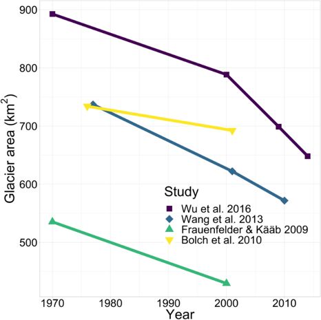
S. Anslan et al.: Processes in the Nam Co catchment                                                                              1265

Table 2. Overview of glacier area changes (%) in the western Nyainqêntanglha range (changed after Wu et al., 2016).

    Period           Region of the Nyainqêntanglha                                         Glacier    Reference
                     range                                                           shrinkage (%)
    1970–2000        Southeastern slope                                                      −5.2     Shangguan et al. (2008)
    1970–2000        Northwestern slope                                                      −6.9     Shangguan et al. (2008)
    1970–2000        Western                                                                 −5.7     Shangguan et al. (2008)
    1977–2010        Western                                                           −22.4 ± 2.9    Wang et al. (2013)
    1970–2009        Western                                                           −21.7 ± 3.4    Wu et al. (2016)
    1970/80–2000     Southwestern                                                           −19.8     Frauenfelder and Kääb (2009)
    1970–2000        Nam Co basin                                                           −15.4     Wu and Zhu (2008)
    1976–2001        Nam Co basin                                                       −6.8 ± 3.1    Bolch et al. (2010)
    1976–2001        Southeastern slope                                                 −5.8 ± 2.6    Bolch et al. (2010)
    1976–2009        Detailed glaciers: Zhadang, Tangse No. 2, Lalong, Xibu, Panu       −9.9 ± 3.1    Bolch et al. (2010)

                                                                       the research into DOM as an important allochthonous source
                                                                       of nutrients and as a capture of biodiversity and geodiver-
                                                                       sity of its respective catchment area is largely lacking for
                                                                       High Asia. The concentration and ratios of different ions in
                                                                       the water have a regulatory impact on the structure of biotic
                                                                       communities (microbes, invertebrates and fish) that can best
                                                                       tolerate abiotic conditions (Wrozyna et al., 2012). In Nam
                                                                       Co, water conductivity has been regarded as the most im-
                                                                       portant environmental factor for shaping communities such
                                                                       as archaea, bacteria, phytoplankton, and micro-invertebrates
                                                                       (Hu et al., 2010; Wang et al., 2011). Studies demonstrated
                                                                       that ammonia-oxidizing archaea (autotrophic microorgan-
                                                                       isms) are key contributors to ammonia oxidation in deep and
                                                                       oligotrophic lakes (Callieri et al., 2016). This has implica-
                                                                       tions for CO2 fixation in the hypolimnion or the benthic zone,
                                                                       where there is insufficient irradiance to support photosynthe-
                                                                       sis, implying that archaea would perform the final step in the
                                                                       decay of organic matter via methanogenesis, resulting in car-
                                                                       bon dioxide accumulation (e.g., when they decrease during
Figure 2. Glacier area reduction in the southwestern Nyainqêntan-      winter). Although nitrification does not directly change the
glha range since 1970 as evaluated in various studies.                 inventory of inorganic nitrogen in freshwater ecosystems, it
                                                                       constitutes the only known biological source of nitrate and
                                                                       as such represents a critical link between mineralization of
landscape disturbance through removing vegetative cover                organic N and its eventual loss as N2 by denitrification or
causes higher rates of DOM leaching, more erosion and in-              anaerobic ammonia oxidation to the atmosphere (Herber et
creasing water runoff velocity, resulting in additional input          al., 2020). Ultimately, the changes in the communities of
of minerals and nutrients into the lake. Since the process of          primary producers could alter the lake’s trophic structure,
DOM leaching and translocation itself is largely dependent             which also affects the top predators of the ecosystem. The
on water and sediment cycles (Kaiser and Kalbitz, 2012), it            primary productivity, as an indicator of nutrient supply and
represents both the seasonal and interannual variation in an           a longer growing period associated with a shorter ice cover
ecosystem as well as its long-term trend. As the glaciers on           duration, has increased markedly at Nam Co within the last
the TP retreat, highly bioavailable DOM may provide addi-              100 years (Lami et al., 2010). Wang et al. (2011) reported the
tional nutrients to downstream environments and amplify the            increasing abundance of the diatom species Stephanodiscus
trend of eutrophication of lotic and lacustrine ecosystems.            minutulus during the last few decades (ca. 1970–2001). This
Furthermore, the rivers on the TP have been shown to trans-            species is generally viewed as an indicator of water phospho-
port dissolved organic carbon from thawing permafrost areas            rus enrichment, suggesting increasing inputs from the lake’s
(Qu et al., 2017), which is likely rapidly degraded via mi-            catchment and stronger mixing in spring season. To predict
crobial activity, resulting in CO2 emissions, thus potentially         future consequences of ongoing climate change, it is essen-
producing a positive feedback on global warming. However,              tial to understand the responses of biotic communities to hy-

www.biogeosciences.net/17/1261/2020/                                                           Biogeosciences, 17, 1261–1279, 2020
1266 S. Anslan et al.: Processes in the Nam Co catchment
drological variations. Thus, long-term monitoring is needed The authors found soils with stronger signs of biologic ac-
to adequately address the feedbacks of recent environmental tivity and chemical weathering (e.g., Cambisols) associated
changes, while climatic conditions of the past can be recon- with alpine pasture sites. Kobresia root mats are usually de-
structed through the study of organisms such as diatoms and veloped in up to 40 cm thick loess layers and form a dis-
ostracods that are sensitive to hydrologic and chemical vari- tinctive felty horizon that protects against erosion. The gen-
ations (see Sect. 3.2). esis of this felty root mat is attributed to Kobresia pygmaea,
since this shallow-rooted, small plant allocates most of its
2.4 Vegetation, soils and pasture degradation in the biomass belowground and is able to reproduce vegetatively,
catchment making it well adapted to the high grazing pressure (Miehe
et al., 2008). The curious dominance of K. pygmaea is often
Nam Co is located in the transitional zone between the cen- linked to grazing: (i) K. pygmaea replaces taller plants at sites
tral Tibetan Kobresia pygmaea pastures and the northwestern where grazing pressure is increased experimentally. (ii) Sev-
alpine steppe ecosystem (Miehe et al., 2019) (Fig. 4). Sit- eral enclosures show that other grasses and shrubs increase
uated on the northern slope of the Nyainqêntanglha range, in dominance after grazing competition ceased (Miehe et al.,
the vegetation pattern changes according to elevation, mois- 2008). Hence, the felty root mat can be seen as an effect of an
ture availability and temperature. Grazing intensity and abun- anthropozoogenic plagioclimax. At higher elevation (5200–
dance of small rodents, such as the plateau pika (Ochotona 5900 m), only sparse alpine vegetation associated with initial
curzoniae), may contribute to the shaping of the vegetation soil processes occurs (Ohtsuka et al., 2008).
cover (Dorji et al., 2014; Miehe et al., 2014). The area close Where water availability is abundant, alpine swamps with
to the lake (< 4800 m) is covered mainly with alpine steppe Carex sagensis and Kobresia schoenoides are formed, espe-
vegetation consisting of Artemisia, Stipa, Poa, Festuca and cially at source areas, along riverbanks and in waterlogged
Carex (Li, 2018; Nölling, 2006). Soils developed in the drier depressions, some of which can cover large areas (Li et al.,
steppe areas consequentially tend to show lower organic car- 2011). Concerning soil development in alpine wetlands, the
bon contents, naturally lowering their total C sink or source database is sparse compared to the alpine pasture and steppe
potential, as indicated by a study from Ohtsuka et al. (2008). biomes. It was pointed out for alpine pastures that a strong
Only one evaluable soil investigation exists from the area relationship exists between plant communities and (top)soil
of Nam Co. Wang et al. (2009b) investigated two lake ter- genesis. This relationship probably also holds true for alpine
race sites, situated in the alpine steppe biome. According to wetlands, with the exception that the influences of water-
their findings, the soils reflect the cold semiarid climate of the logging and seasonal fluctuations and frost–melt cycles in
area by showing low biologic activity, while the influence of the water table are likely to have an effect on soils. This
physical weathering is dominant. The soils showed several can be expressed in terms of formation of gleyic features,
decimeter-thick layers of loess in which mainly the A hori- frost turbations, heaves or other azonal features related to
zons were developed. Although only very sparse to moderate the soil-forming effects of water (Chesworth et al., 2008).
vegetation cover occurs, an almost 30 cm thick organic-rich It still needs to be clarified how these waterlogged areas af-
topsoil with granular structure was developed there (Wang et fect the cycling and processing of organic matter and nutri-
al., 2009b). Further organic-rich buried horizons were found ents. There is no evidence of tree species, only the evergreen
and dated in both profiles, showing phases of climatic con- shrubs of Juniperus pingii var. wilsonii, which are mainly
ditions enabling the buildup of organic material related to found on the south-facing slopes of the northern Nam Co
warm wet periods in the past (before 2.4 and 1.6 ka cal BP) catchment, and shrubs of Salix spp. in the Niyaqu Valley in
and interchanging with phases of erosion, leading to, e.g., the eastern lake catchment (Li, 2018). Alpine steppe is com-
sheet erosion and the formation of gullies and alluvial fans prised of more plant species compared to pasture and marsh
supposedly during colder periods. These results fit well to ecosystems, which are predominantly covered with Carex
climate reconstructions presented in Sect. 3.3 of our review. spp. and Kobresia spp. (Miehe et al., 2011b). Alpine pastures
In accordance with the World Reference Base for Soil Re- are often described as “golf-course-like” (Miehe et al., 2014)
sources (WRB) classification, we propose that the soils de- with the intention of illustrating their unique plane surface.
scribed by Wang et al. (2009b) can be classified as Calcisols, However, small-scale structures such as thufa or hummocks
as there is evidence of carbonate translocation. are also present. The origin of these structures around Nam
Higher up the slope (4800–5200 m), the alpine steppe is Co remains unclear; however, frost heave and permafrost
replaced by Kobresia pygmea pasture. Wang et al. (2007) degradation processes are seen to play a major role (Adam-
and Kaiser et al. (2008) investigated the relationship be- czyk, 2010). The landscape, generally dominated by endemic
tween plant communities and development of soil types on Kobresia pygmea sedges, harbors only a few other species
the High Asian Plateau and for pasture soils in the wider (Miehe et al., 2019), but the additional microhabitats pro-
area. Vegetation strongly controls the input of organic mate- vided by thufa and hummocks enable rarer and less compet-
rial into the soil but beyond that also stabilizes fine materials itive species to settle in niches in these heterogeneous struc-
(< 0.1 mm) and governs the degree of chemical weathering. tures (Vivian-Smith, 1997). Compared to the surroundings,
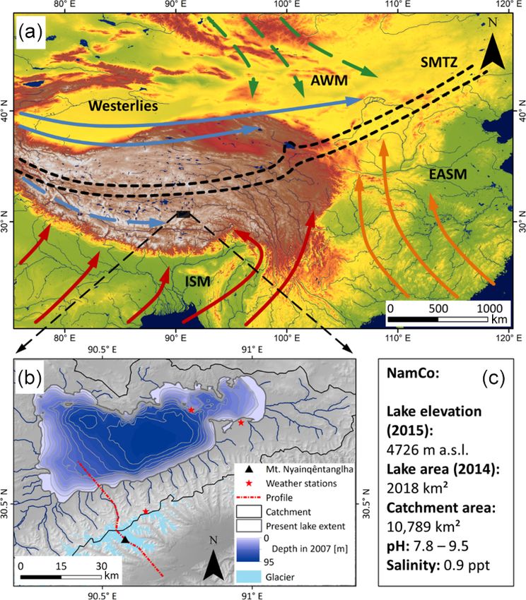
Biogeosciences, 17, 1261–1279, 2020 www.biogeosciences.net/17/1261/2020/S. Anslan et al.: Processes in the Nam Co catchment 1267 Figure 3. (a) Lake level changes of Nam Co since 2000 (there is notable shift in the water balance in 2009), and (b) changes of the lake surface area since 1970, as evaluated in previous studies. The overall increase rate of lake area is 2.1 km2 yr−1 . Red lines denote LOESS curves, with the 95 % confidence interval shown in gray. the microtopography of thufa possesses different degrees of degradation (Wang et al., 2007), although the effects of ris- wetness, exposition and insulation; depth of soil material; ing temperatures and increasing precipitation appear to be an and type of topsoil. Local studies of the Nam Co area state intensifier rather than the cause of degradation (Zhou et al., that slightly degraded bare soil patches and gullies are of- 2005; Harris, 2010). In turn, both Wang et al. (2018b) and ten areas where plants have the chance to evade the suppres- Cao et al. (2019) point out that a multitude of effects might sion of the closed Kobresia pygmea root mat (Schlütz et al., be in play, with a locally differing magnitude or even rever- 2007; Dorji et al., 2014). Thus, the genesis of thufa and mild, sion, while usually moderate grazing was not found to cause limited degradation processes are likely to increase species degradation. Certainly there are more factors than just graz- richness and diversity by cracking open the closed root mat ing pressure, and there might be site-specific effects leading of alpine pastures. These structures can also be formed by to nonequilibrium behavior of the study object, be it pasture grass species that grown in tussocks (i.e., clumps, bunches or steppe (Wang and Wesche, 2016). Plot-level experiments or tufts), such as the endemic species Stipa purpurea (Liu et from the Nam Co area found warming to have significant ef- al., 2009) or Kobresia tibetica (Yu et al., 2010) and Kobresia fects on the shallow-rooted Kobresia pygmaea by reducing schoenoides (Nölling, 2006). the number of flowers and delaying its reproductive phenol- The often-cited degradation of alpine pastures is likely ini- ogy. These changes were provoked by simulating increasing tiated by natural polygonal cracking (Miehe et al., 2019), precipitation by means of snow addition (Dorji et al., 2013) which can occur through drying (Velde, 1999) and then tends and also by maintaining a moderate level of grazing com- to be amplified by livestock trampling and plateau pikas bined with snow addition (Dorji et al., 2018). This underlines using the cracks as highways (Liu et al., 2017b; Hopping the importance of climate forcing on the terrestrial systems et al., 2016). Overgrazing in alpine pastures is one of the in the Nam Co catchment. Grazing should not be seen as a most frequently mentioned causes of pasture degradation disturbance but as an integral part of a non-steady-state but (Unteregelsbacher et al., 2012; Harris, 2010; Miehe et al., plagioclimax environment. Currently there are no estimates 2008), as excessive trampling by livestock might aggravate of the extent of degraded land at Nam Co, but the degrada- the initial conditions of polygonal cracking (Miehe et al., tion of wide areas of alpine pastures is not without conse- 2019). This effect, however, seems to be limited to the direct quences for pastoralist communities. The severe degradation vicinity of herder’s settlements and camps (piosphere cen- and sloughing off of the whole topsoil removes the basis for ters), and many factors that are usually attributed to degra- business and might lead to unknown consequences for the dation are instead proof of environmental control, especially lake ecosystem by means of enhancing or terminating nutri- in drier areas (Wang et al., 2018b). Some researchers argue ent exchanges. The economic rationale of herders might be to that climate change is the dominant or even sole driver of increase the numbers of livestock, as this represents a form of www.biogeosciences.net/17/1261/2020/ Biogeosciences, 17, 1261–1279, 2020
1268                                                                   S. Anslan et al.: Processes in the Nam Co catchment

social security (Simpson et al., 1994). The bottom line is that   as well as community changes, affect the local carbon cy-
conflicts arise as less land is available for grazing (Hopping    cle. Alpine grassland root mats on the TP are estimated to
et al., 2016).                                                    store up to 10 kg of carbon (C) per square meter (Li et al.,
   The Chinese government has favored policies such as            2008b), summing up to roughly 2.5 % of the global terrestrial
sedentariness and fostered the construction of stationary set-    carbon stocks (Wang et al., 2002). At Nam Co, the topsoils
tlements, which have, in turn, created hotspots of overgrazing    contain an almost 30 cm thick organic-rich layer (Wang et
(Miehe et al., 2008). In these hotspots, large portions of the    al., 2009b), thus representing considerable soil organic car-
topsoil are lost by erosion and denudation, leaving only an       bon (SOC) stocks. Due to higher plant productivity, alpine
area of humic material or subsoil, thus being called “black       meadows in general represent a CO2 sink; however, the in-
beach” (Miehe et al., 2008) or “black-soil patch” (Liu et al.,    terannual and seasonal uptake is highly variable (Kato et al.,
2017a). The remaining landscapes are usually dry, poor in         2004, 2006; Gu et al., 2003). Like plant productivity, the
plant cover and prone to further degradation. Increasing areas    CO2 uptake depends on water availability and temperature,
of bare soil patches enhance evapotranspiration, causing ear-     which exhibit diurnal, seasonal and annual fluctuations. The
lier cloud cover formation, especially before noon. This may,     overall great importance of water availability and tempera-
in turn, lead to reduced radiation and temperature at the sur-    ture on ecosystem–atmosphere CO2 exchange in the central
face, thus hampering photosynthesis and consequently over-        Tibetan alpine Kobresia meadows was demonstrated in sev-
all carbon sequestration (Babel et al., 2014). However, the       eral studies through eddy covariance measurements (Zhang
evolution of grasslands on the TP has been accompanied by         et al., 2018), chamber measurements (Zhang et al., 2018;
herbivore communities; thus, the plants have developed cop-       Zhao et al., 2017), decomposition of cellulose cotton strips
ing mechanisms to persist under continuous grazing pressure       (Ohtsuka et al., 2008) and altitudinal transplantation experi-
(Miehe et al., 2011a). According to the intermediate distur-      ments (Zhao et al., 2018). Similarly, carbon fluxes in alpine
bance hypothesis, species diversity is higher under moderate      steppe biomes are driven by precipitation and temperature
disturbances, which suggests the positive effect of intermedi-    on a daily to seasonal and annual timescale. The interan-
ate level of grazing pressure. Indeed, a plant clipping exper-    nual flux variability follows the varying monsoonal precip-
iment to simulate grazing demonstrated that under the effect      itation, showing a stronger tendency towards functioning as
of climate warming, the grazing activities mitigated the neg-     a C sink in wetter years and as a C source in drier years
ative effects of rising temperature by maintaining a higher       (Wang et al., 2018a; Zhu et al., 2015b). Soils that develop
number of plants (Klein et al., 2008). Many studies hold the      in the drier steppe areas tend to show lower organic carbon
traditional nomadic practice to be a sustainable one (Miehe       contents, therefore lowering the total C sink and source po-
et al., 2008; Babel et al., 2014; Hafner et al., 2012), but the   tential (Ohtsuka et al., 2008). Although the production of
current policy of removing pastoralist lifestyles from certain    plant biomass may be hampered in steppes, the ecosystem
regions could potentially reduce overall species richness.        may still act as a carbon sink through microbial CO2 fixing
                                                                  activities, as shown by a recent study on the TP that reported
2.5    Effects on carbon cycling in alpine ecosystems             relatively high CO2 fixation capacity (29 mg kg−1 soil d−1 ,
                                                                  Zhao et al., 2018). Interestingly, this study also found that
Changes in temperature and moisture have a significant ef-        alpine steppe soils demonstrated significantly higher micro-
fect on the biotic community structure with feedbacks on          bial CO2 fixation capacity compared to meadow soils (29 vs.
ecosystem productivity. Alpine meadows respond with in-           18 mg kg−1 soil d−1 , respectively).
creased plant productivity to warming, while productivity            As a result of increasing precipitation and glacier runoff,
may be hampered in alpine steppe ecosystems (Ganjurjav et         wetlands in the Nam Co area are expanding, thus increas-
al., 2016). As soil moisture governs the community response       ing emissions of CH4 , which is 28 times more climate ac-
to warming, negative effects of warming on plant produc-          tive than CO2 (IPCC, 2013). A study conducted in the alpine
tivity likely occur due to limited water availability (Ganjur-    wetlands around Nam Co reported that CH4 emissions have
jav et al., 2016). Warming was also reported to have a nega-      increased exponentially with increasing precipitation, espe-
tive effect on plant species diversity in both alpine meadow      cially when soil moisture exceeded 80 % (Wei et al., 2015).
and steppe ecosystems (Klein et al., 2008; Ganjurjav et al.,      However, there was a large difference between swamp mead-
2016). Possible explanations for a decline in plant species       ows and swamps (67 and 1444 µg CH4 m−2 h−1 , respec-
diversity include changes in small mammal activity, storage       tively). Swamps are permanently inundated, while swamp
of belowground nutrient resources and water stress and mi-        meadows are usually seasonally inundated. Furthermore,
croclimate in general (soil temperature and moisture) (Gan-       SOC stocks are higher in swamps compared to swamp mead-
jurjav et al., 2016; Klein et al., 2008, 2004). Thus, climate     ows (Wei et al., 2015). Large amounts of SOC in combi-
change may reduce the habitat quality for the local popula-       nation with anoxic conditions are the main precursors for
tions of grazers and reduce the well-being of the pastoral-       methanogens activity, which results in increasing CH4 emis-
ists by diminishing the abundance of palatable and medicinal      sions to the atmosphere (Kato et al., 2013). Thus, the satu-
plant groups. The changes in the plant productivity levels,       rated soils with high SOC content produce higher CH4 emis-

Biogeosciences, 17, 1261–1279, 2020                                                   www.biogeosciences.net/17/1261/2020/
S. Anslan et al.: Processes in the Nam Co catchment 1269
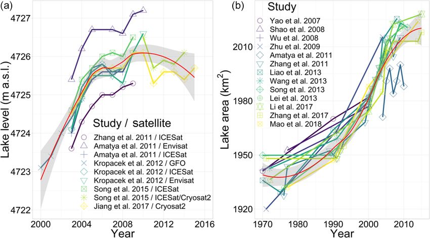
Figure 4. (I) Cross section from Damxung valley to the Nam Co study area (A’–A), as shown in Fig. 1b. Schematic depiction of altitude-
dependent biomes and azonal landforms; changes in chroma denote height-dependent biome shifts. Approximate biome heights were gained
from satellite imagery (Sentinel-2B) and herewith-derived vegetation indices, field excursions, and the literature review (Ohtsuka et al., 2008;
Wang and Yi, 2011). (II) Frequency, direction and velocity of mean daily wind measurements at the NAMORS (30◦ 460 2200 N, 90◦ 570 4700 E)
between 2005 and 2015.
sions (Deng et al., 2013). Observations from 2008 to 2013 that the rate of N2 O emission may increase with increas-
at Nam Co have shown that alpine steppe and alpine mead- ing soil temperature and soil moisture under a future climate
ows show annual uptake rates of 72 and 59 µg CH4 m−2 h−1 , change scenario (Yan et al., 2018; Yingfang et al., 2018). Ex-
respectively (Wei et al., 2015); however, the corresponding panding wetland areas provide anoxic conditions for the re-
emission rates are much higher. Generally, it is expected that lease of methane and, due to the greater temperature sensi-
the alpine wetland acts as a CH4 source, while the aerated tivity of permafrost areas, subsurface SOC is at high risk of
soils of alpine steppe and alpine meadow act mainly as a CH4 loss, which may decrease the carbon sequestration potential
sink. in the region (Li et al., 2018). Besides carbon cycling through
As the grasslands on the TP are widely used for yak decomposition processes, responses to changing temperature
and sheep grazing, carbon cycling is influenced particularly and precipitation depend on the composition of decomposer
through human activities and the degree of degradation. The communities (Glassman et al., 2018). Thus, the conclusive
intensity of grazing has a significant effect on CO2 fluxes, effects and feedback mechanisms (i.e., positive vs. negative
with moderate grazing enhancing belowground allocation of loop) on warming are complex and not always clear.
carbon (Hafner et al., 2012), while adversely affecting the
C-sink potential through reduction of aboveground and be-
lowground biomass at higher grazing intensities (Babel et 3 Paleoenvironments on the Tibetan Plateau and
al., 2014). Overgrazing, along with the increase in burrow- landscape evolution at Nam Co
ing pikas in the Tibetan grasslands, may increase nitrous ox-
ide (N2 O) emissions (Zhou et al., 2018), an important green- 3.1 Geodiversity and evolution of biodiversity
house gas with 297 times larger warming potential compared
to CO2 (IPCC, 2013). Despite several studies focusing on Topography, geological context, climate and their complex
greenhouse gas emissions on the TP, the magnitude of the interplay are key determinants for the distribution of organ-
N2 O emissions in different ecosystems has not yet been esti- isms. In general, the ecoregion can serve as a proxy for
mated. Experimental studies on the eastern TP demonstrated community- and species-level biodiversity, which best de-
scribe communities of mammals, birds and plants (Smith et
www.biogeosciences.net/17/1261/2020/ Biogeosciences, 17, 1261–1279, 20201270 S. Anslan et al.: Processes in the Nam Co catchment al., 2018). The TP forms a distinctive zoographical region, Several authors claim the existence of a much larger fluvial an “ecological island” (Deng et al., 2019), characterized by lake system called Old Qiangtang Lake, which covered an fauna that are adapted to high altitudes, drought, low temper- area of around 30 000–50 000 km2 or more (Li et al., 1981; atures and low oxygen levels (He et al., 2016). The TP forms Zhu et al., 2002). The connections provided by a large lake unique high-altitude biogeographical biota by also harboring allowed gene flow between drainages, which is reflected, for many unique lineages of other organisms, with a higher en- example, by the closely related clades of schizothoracine fish demism of low dispersal species (Yang et al., 2009; Clewing (Cyprinidae, Osteichthyes) from Nam Co and the surround- et al., 2016). As mountain building has been directly asso- ing lakes, compared with more distant parts of the TP (He et ciated with the development of biodiversity (Hoorn et al., al., 2016). In contrast, due to a vector-mediated passive dis- 2013; Antonelli et al., 2018), the biodiversity hotspots are persal across large areas, other aquatic taxa, such as freshwa- located in the south and southeast of the TP especially. There ter snails, seem to have been less influenced by drainage his- is also a pattern of increasing biodiversity from west to east, tories (Oheimb et al., 2011). Higher lake terraces are older, which correlates positively with increasing precipitation. In suggesting a long-term reduction in lake level (Zhu et al., contrast, the harsh central areas of the TP show much lower 2002). This may be associated with an evolution from wet richness but nevertheless harbor various endemics (Päckert to dry phase, which Li et al. (1981) connects to the gradual et al., 2015). Throughout the geological formation of the TP, uplift of the plateau from early Pleistocene to the Holocene. the mountainous southeastern parts have been hypothesized However, there is an alternative suggestion to this interpre- to serve as center of species diversification (Mosbrugger et tation of a rather modern uplift proposed by Renner (2016) al., 2018), although the core TP region is also suggested to who states that large parts of the TP had already reached av- represent a center of origin (Deng et al., 2011). The TP has erage heights of 4000 m and more during the mid-Eocene been a source area for several mammalian lineages (“Out of (∼ 40 Ma ago). Recent findings of palm leave fossils on the Tibet hypothesis”; Deng et al., 2011), including the snow central part of the TP, dated to ca. 25.5 ± 0.5 million years, leopard and the arctic fox (Wang et al., 2015), as well as do not suggest a presence of such a high plateau before the birds, such as redstarts (Voelker et al., 2015), and plants, such Neogene (Su et al., 2019). Thus, although it is suggested as Gentiana (Favre et al., 2015). These mountainous areas that the final large lake phase took place ca. 40–25 ka cal BP may also have acted as refugia, which preserved unique lin- (Lehmkuhl et al., 2002; Zhu et al., 2002), the complex rela- eages over long periods (López-Pujol et al., 2011; Lei et al., tionship between evolution of the TP and the development 2014). Whether some endemic taxa represent relics of a for- and the temporal existence of Old Qiangtang Lake are not merly more diverse clade or have never extensively diversi- completely resolved. fied remains unclear (Päckert et al., 2015). Besides being a center of origin, the TP may represent a center of accumula- 3.2 Holocene lake level changes and climate tion as proposed by the examples of Saxifraga (Ebersbach reconstruction based on aquatic bioindicators et al., 2017), warblers (Johansson et al., 2007) and hyno- biid salamander (Zhang et al., 2006). Overall, the regional Lake sediments contain important indicators or proxies that biota of the TP is comprised mainly of Palearctic and Orien- can be used to reconstruct limnological and (hydro-) cli- tal species, Nearctic species from the Bering land bridge, as matic conditions over long time periods (Zhu et al., 2010a; well as species from speciation in situ and postglacial recol- Wrozyna et al., 2010). Widely used environmental indicators onization from adjacent areas. The evolution of biodiversity include communities of diatoms (Bacillariophyceae) and os- on the TP has been affected by the combination of geological tracods (Crustacea) as they are abundant and usually preserve and climatic changes over the time of the uplift phases (Mos- well in sediments (Kasper et al., 2013). For example, the in- brugger et al., 2018). Although many studies have associated vestigations of Quaternary ostracods, modern assemblages, recent in situ radiations to different uplift phases of the TP, and stable isotopes from Nam Co and nearby water bodies Renner (2016) pointed out that the evidence for recent rapid represent the most detailed application of ostracod analy- uplift (9–8 or 3.6–2.6 Ma) remains doubtful and controver- sis in the south–central region of the TP (Mischke, 2012). sial. As proposed by the “mountain geobiodiversity” hypoth- Different approaches (stratigraphy, paleoecology, etc.) de- esis, the evolution of biodiversity on the TP is a result of an tected several climatic fluctuations between warmer–cooler increasing local geodiversity in combination with rapid cli- and wetter–drier periods (Fig. 5). In general, higher lake lev- matic oscillations and steep ecological gradients (Mosbrug- els based on aquatic fauna suggest a more humid environ- ger et al., 2018). ment during the early and middle Holocene, which displayed The combination of geological, climatic and ecological a shift pattern compared to the northern TP (Wünnemann changes has left its footprint in the history of Nam Co. et al., 2018). Together with the indicator species approach There are at least seven different levels of continuous ter- and the application of transfer functions for Nam Co sedi- races around Nam Co, with the highest being over 30 meters ments, different stages can be recognized. In Stage I (8.4– above the current lake level, corresponding well with the el- 6.8 ka cal BP), the climate changed from warm humid to cold evation of the natural spillway in the northeast of Nam Co. arid with water depth being much lower than today (Zhu Biogeosciences, 17, 1261–1279, 2020 www.biogeosciences.net/17/1261/2020/
S. Anslan et al.: Processes in the Nam Co catchment                                                                         1271

et al., 2010a). In Stage II (6.8–2.9 ka cal BP), environmental     tion patterns contribute to the reconstruction of past climate
conditions returned to warm and humid (Zhu et al., 2010a).         and the assessment of the degree of local human influence.
During 4–2 ka cal BP, lake water depth initially remained          Modern vegetation belts around Nam Co reveal that alpine
much shallower than today but then gradually increased due         steppes contain mostly species of Artemisia (Asteraceae) and
to high rates of precipitation (Frenzel et al., 2010). The pres-   Poaceae, while alpine meadows and swamps are dominated
ence of the diatom taxa Stephanodiscus in this stage indicates     by Cyperaceae (Li et al., 2011). The sedimentary pollen ra-
stronger monsoon activity and higher availability of nutri-        tio of Artemisia to Cyperaceae (A/Cy) can, within certain
ents (Kasper et al., 2013). Finally, in stage III (2.9 ka cal BP   limitations, be used to reconstruct past climates (Li et al.,
to present), the climate again became warm humid, with a           2011; Li, 2018; Zhu et al., 2015a) provided that vegetation
cold dry event between 1.7 and 1.5 ka cal BP (Zhu et al.,          belts move with altitude during climate change. For example,
2010a). Between 2 and 1.2 ka cal BP, benthic diatoms in-           when the climate is warmer and drier, alpine steppe reaches
ferred a lower water level and drier climate (Kasper et al.,       higher up the mountain, displacing alpine meadow into ar-
2013). Subsequently, wetter conditions and an increase in          eas further away from the lake, leading to a higher input
lake level was detected (1.2 ka cal BP until 250 cal BP), pos-     of Artemisia pollen into the nearby lake and consequently
sibly corresponding to the Medieval Warm Period (MWP),             a higher A/Cy pollen ratio in the sediments. However, the
with high planktonic diatom species and high ostracod di-          A/Cy pollen ratio and abundance of tree pollen originating
versity (Kasper et al., 2013). During the late Holocene, the       from a short distance can be altered by human-driven change
minimum water level occurred throughout the Little Ice Age         of plant composition, hence the beginning of pastoral econ-
(LIA) (∼ 1490 and 1760 CE) (Frenzel et al., 2010). However,        omy might limit the explanatory power of pollen records
the lake level increased towards the present, which is plausi-     (Adamczyk, 2010; Miehe et al., 2014). Pollen composition
bly linked to the melting of the glacier due to the current        inferred from sediment cores reveals a downward shift of the
warming.                                                           altitudinal vegetation belts since 8.4 ka BP (Li et al., 2011).
   Although a large number of studies describe profound hy-        A major extension of alpine pasture and alpine sparse veg-
drological changes and general climate fluctuations, there         etation closer to the lake shore during the late Holocene is
are several uncertainties regarding taxonomy, resolution and       corroborated by a pollen-based climate reconstruction from
proxy sensitivities. For example, modern ostracod data de-         a peat core near Nam Co (Herrmann et al., 2010) and two
tects several morphological variations, characterized by dif-      other pollen records from the eastern lake shore (Adamczyk,
ferent nodding or shell sizes, which could lead to an er-          2010). They found a trend of increasing temperatures from
roneous ecological interpretation and later, vague pale-           the late glacial until the early Holocene, accompanied by
oenvironmental conclusions in relation to salinity changes         an extension of alpine steppe, tree and shrub vegetation. Al-
(Fürstenberg et al., 2015). In paleo-studies, different sedi-      ready in this period, synanthrope taxa pollen are increasing
mentation rates and uncertainties in the core chronologies         in the data used by Adamczyk (2010) with the only small oc-
also cause a lack of correspondence between signals de-            currence of, for example, Plantago lanceolata in the whole
tected by different proxies (Wang et al., 2012). For this rea-     profile. This very early signal shows that a lot of room still
son, it is surrogate to understand the precise causal relation-    exists for studies of pollen archives around Nam Co, with
ships between a complex environmental gradient (e.g., water        much doubt still persisting at present. Climate fluctuated be-
depth, water chemistry, temperature, etc.) and the response of     tween dry and humid from 8.5 to 4.8 ka BP, with an intense
bioindicators. Although ecological information is still poorly     cold regression between 8.1 to 7.8 ka BP. The onset of human
known for many species, ostracod and diatom assemblages            activity at Nam Co is dated to 5.6 ka BP according to synan-
represent reliable proxies to trace the climatic history of Nam    thrope taxa proxies (Li et al., 2011; Herrmann et al., 2010).
Co.                                                                Between 4.8 and 0.7 ka BP, a relatively stable climate with
   Further emphasis should be placed on combining mor-             predominantly humid conditions developed (Fig. 5), and the
phology and DNA analysis to corroborate the classification         vegetation pattern already showed trends of a human-made
of the species already described. Furthermore, experiments         steppe biome, potentially a plagioclimax (Adamczyk, 2010).
with living individuals should be performed under controlled       Since 0.7 ka BP, drier conditions prevailed.
environmental variables to allow the setup of a transfer func-        Whether and to what extent the central Tibetan Plateau
tion that could be used to evaluate quantitative data for paleo-   was forested and what caused the forest decline are the sub-
reconstructions.                                                   ject of ongoing discussion (Miehe et al., 2006, 2019). This
                                                                   matter is closely related to the prior discussed onset of more
3.3   Holocene vegetation cover and climate                        intense human activity in the area, since parts of the discus-
      reconstruction based on pollen records                       sion involve a human-made forest clearing in combination
                                                                   with a natural forest decline. As stated, there are only oc-
The comparison of modern pollen assemblages with those             currences of shrubs (Juniperus pingii var. wilsonii and Salix,
from sediment cores allows the reconstruction of floristic         Nölling, 2006) in the Nam Co area. No remains and no re-
diversity and distribution across various timescales. Vegeta-      liable evidence of a once tree-rich vegetation have yet been

www.biogeosciences.net/17/1261/2020/                                                      Biogeosciences, 17, 1261–1279, 2020
1272 S. Anslan et al.: Processes in the Nam Co catchment
Figure 5. Comparisons of the reconstructed climate conditions based on fossils of pollen (Li et al., 2011; Adamczyk, 2010; Herrmann et al.,
2010), ostracods (Zhu et al., 2010a), Ostracod δ 18 O (Wrozyna et al., 2010, 2012) and diatoms (Kasper et al., 2013) from sediment cores in,
and at the shoreline of, Nam Co. Ostracod-based water depth transfer function (Zhu et al., 2010a) (blue line) was used to indicate long-term
hydrological changes and all reconstructed water depth values were adjusted to the maximum water level of the lake according to the 45 m
difference between this study site (60 m) and the deepest site (105 m) at Nam Co. The main species are also shown in different periods.
found in the Nam Co catchment. According to locals, there authors, the trees were previously able to spread again due
exist several caves with potentially (pre)historic tree depic- to sufficient precipitation provided by the summer monsoon.
tions of unknown age. Unfortunately, there is no verification Furthermore, the occurrence of synanthropic taxa has been
of their existence nor any dating approach. Since the area of observed in the nearby Damxung valley since 8.5 ka cal BP,
Damxung still does feature larger occurrences of Juniperus corroborating the strong anthropogenic influence on the for-
pingii var. wilsonii and, around 4250 m a.s.l., tree stands of mation and restructuring of the vegetation patterns in the area
Juniperus tibetica in enclosed areas, there is the potential to (Schlütz et al., 2007). The decrease in summer precipitation
discuss that these species have been more numerous in this and temperature, in conjunction with ongoing human activ-
area in the past (i.e., last tooth theory). Miehe et al. (2019) ity, ultimately led to the total disappearance of trees and the
show locations of forest relicts and give a drought line of formation of the alpine grasslands and steppe as we know
200–250 mm precipitation and elevations between 3600 and them today (see Sect. 2.4). Furthermore, the occurrence of
4000 m a.s.l. as the upper tree line. Questions arise as to synanthropic taxa has been observed in the nearby Damxung
whether there has been an expansion of J. tibetica into the valley since 8.5 ka cal BP (Schlütz et al., 2007). This corrob-
Nam Co catchment in earlier times, which would be feasible orates the strong anthropogenic influence on the formation
within certain limitations according to the presented thresh- and restructuring of vegetation patterns in the area but leaves
olds. Charred micro remains as a potential sign of fire-driven a time gap of almost 3 ka between the evidence from Damx-
forest decline are missing in one of the profiles of Adam- ung valley and Nam Co. Hence, further research is needed to
czyk (2010) but can be found throughout the Holocene until address the question of onset of human activity and degree of
1 ka cal BP (Herrmann et al., 2010). The authors attribute the landscape modification.
size and shape of the charcoal remains to local, small-scale
burning of wood and leaves, not showing signs of larger for-
est clearings. In addition to the burning of Juniperus trees for 4 Conclusions and perspectives
religious reasons (Miehe et al., 2006), trees and shrubs may
have been burned for heating or clearing of pastures by no- This literature review summarizes the manifold environmen-
mads. Following the presumptuous argumentation of some tal changes affecting abiotic and biotic processes in the area
caused by past and ongoing climate change. Ecosystems on
Biogeosciences, 17, 1261–1279, 2020 www.biogeosciences.net/17/1261/2020/You can also read