Route Weather Resilience and Climate Change Adaptation Plans - Scotland - Network Rail
←
→
Page content transcription
If your browser does not render page correctly, please read the page content below
Route Weather Resilience
and Climate Change
Adaptation Plans
Scotland
Scotland Route: WRCCA plan

Contents
Director Route Asset Management statement                                                         2

Executive summary                                                                                 3

Introduction                                                                                      4

Scotland Route WRCCA strategy                                                                     7

Scotland Route vulnerability assessment                                                           8

Scotland Route impact assessment                                                                 19

Scotland Route WRCCA actions                                                                     35

Management and review                                                                            39

Purpose of this document
This document sets out a Weather Resilience and Climate Change Adaptation (WRCCA) plan
for Scotland Route supported by an evaluation of the resilience of rail infrastructure to historical
weather events and an awareness of potential impacts from regional climate change
projections. The resilience of rolling stock operating within the Route is not specifically
assessed.
The approach taken is consistent across all Network Rail’s Routes, and describes our current
planned mitigations, how we intend to develop the plans further, and how we are improving the
embedment of WRCCA across the business to deliver a railway fit for the future.

Network Rail                                                                                           1
Scotland Route: WRCCA plan

Director Route Asset Management statement
                                           Climate change presents us with an unprecedented challenge to understand how shifts in
                                           temperature and rainfall will impact our network and to identify the actions we can take to
                                           proactively increase our weather resilience.
                                           In response to this challenge Scotland Route has developed a Weather Resilience and
                                           Climate Change Adaptation (WRCCA) plan which incorporates a number of programmes
                                           and initiatives designed to increase resilience of the railway in Scotland to effects of weather
                                           and climate change.
                                           Scotland is no stranger to the best and worst of the weather. In recent years we experienced
                                           the prolonged spell of heavy snow fall in 2010/11 and the severe rain and wind in 2012 and
                                           2013. Our ability to support the quality of rail service our customers expect is highly dependent
                                           on the capability of our assets to be resilient and our operational responses to weather events
                                           to minimise disruption.
                                           Scotland Route has made significant investments in recent years to strengthen the railway
                                           network against the effects of the weather. Examples include over £5m improving the
                                           resilience of the railway to flooding risk at Dalmarnock, protecting Gourock from coastal
                                           impacts and undertaking extensive drainage and earthworks at Drem. In CP5 we are
                                           continuing to increase weather resilience through our investments, including drainage
                                           improvements, installation of remote condition monitoring, earthwork renewals and improving
                                           our real-time weather data.
                                           We will do this in collaboration with our rail industry partners and other stakeholder
                                           organisations.

Track washout at Dalguise, December 2006
                                           Alan Ross
                                           Director Route Asset Management
                                           September 2014

Network Rail                                                                                                                                  2
Scotland Route: WRCCA plan
Executive summary
Weather events can cause significant disruption to the operation of train services and damage Scotland Route is committed to supporting the delivery of improved weather and climate
to rail infrastructure. A move to a warmer climate and a variance in the pattern of precipitation change resilience through the following Route-specific objectives:
across the year, generally projected by the UK Climate Change Projections (UKCP09), could
increase the understanding of climate change impacts on the Scotland Route
result in changes in the frequency and intensity of extreme weather events and seasonal
improve the knowledge of weather impacts through identification of root causes and trends
patterns. A detailed understanding of the vulnerability of rail assets to weather events, and
to support the identification of cost effective resilience measures
potential impacts from climate change, are therefore needed to maintain a resilient railway.
develop and manage a Route Climate Change Adaptation Plan to inform current and future
In response to this challenge Scotland Route has developed a Weather Resilience and Climate Control Period investment plans and work banks
Change Adaptation (WRCCA) plan based on assessments of weather-related vulnerabilities, include climate change adaptation in Project Requirement Specifications for renewals and
identification of root causes of historical performance impacts and an understanding of new works
potential future impacts from regional climate change projections. improve operational responses to extreme weather events
support initiatives and demonstration projects aiming to deliver network-wide resilience
Using this information, Scotland Route has determined whether previous investments have
improvements
mitigated weather impact risks, if actions planned during Control Period 5 (2014 to 2019) are
engage with key regional stakeholders to communicate the Scotland Route strategy, planned
addressing these vulnerabilities, and where additional actions could further enhance weather
programmes of work and identified climate change adaptation actions, including the Scotland
and climate change resilience.
Environment Protection Agency and Transport Scotland.
An analysis of Schedule 8 performance costs (the compensation payments to train and freight
Scotland Route has identified actions planned in CP5 that will increase weather and climate
operators for network disruption) during the period 2006/07-2013/14 clearly shows wind,
change resilience including:
flooding and snow-related events have had the most significant impact on the Route.
increase forecasting capability and real-time weather data
£12 engage with the Scottish Environment Protection Agency and Local Authorities to achieve
Millions
sustainable solutions to reduce flood risk
Adhesion roll out strategic programmes of Remote Condition Monitoring for
£10
Cold – high-risk earthworks
– high-risk flooding sites
£8 Flood – air conditioning in lineside buildings
Lightning – points operating equipment
engage with wider industry, including train operating companies, to minimise delay impacts.
£6 Snow
Wind Scotland Route will deliver the WRCCA plan in a timely, cost-efficient and safe manner.
£4 Earthslip
Heat
£2 Fog
£0
Scotland
Figure 1 Scotland Route weather attributed Schedule 8 costs 2006/07-2013/14
Network Rail 3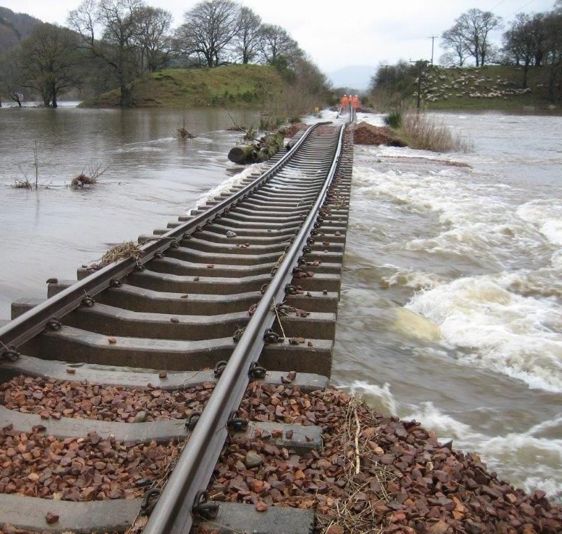
Scotland Route: WRCCA plan

Introduction
Weather events can be a cause of significant disruption to the railway network. Recent           Following the recent increase in the rate of these compensation payments (by around 62%),
prolonged periods of rainfall and severe storm events demonstrated much of the network           the equivalent payments in future years would be over £80m per annum.
is resilient; however, asset failures such as flooding at Winchburgh and Dalguise, earthslips
                                                                                                 These levels of performance cost, consequential costs of repairing the rail infrastructure, and
at Loch Treig and on the West Coast Main Line, the cyclone of 3 January 2013 and the high
                                                                                                 wider socio-economic impacts in the UK, justify Network Rail’s enhanced investments to
winds of 5 December 2013 when the Scotland network shut down due to severe high winds,
                                                                                                 increase weather resilience. The interdependencies within transport and infrastructure systems
reveal the vulnerability of the rail network and the impact these weaknesses in resilience can
                                                                                                 similarly justifies Network Rails’ efforts to improve collaborative understanding of the wider
have on train services and our resources.
                                                                                                 impacts of weather-related events and our role in supporting regional and national resilience.
The impact of weather on the rail network is monitored using performance data. Schedule 8
                                                                                                 Historical temperature records indicate that a significant relatively recent shift in climate has
costs; the compensation payments to train and freight operators for network disruption, are
                                                                                                 occurred; Figure 3 clearly shows a rising trend in Scotland temperature over the past 40 years.
used as a proxy for weather impacts due to greater granularity of root cause reporting.
Weather-related costs can also be captured within Schedule 4 payments; compensation to
train and freight operators for Network Rail’s possession of the network, and capital
expenditure required to reinstate the asset.
Over the past eight years, 2006/07 to 2013/14, the average annual performance cost attributed
to Schedule 8 weather for the whole network was over £50m. The data clearly includes the
impacts on train performance from the severe weather events during 2007, 2012 and 2013
from rainfall, and 2009 and 2010 from snowfall, Figure 2. In terms of the proportion of delay,
weather and seasonal events on average caused 12% of all delays experienced during this
eight-year period.

            £100
 Millions

             £90
                                                                                    Fog
             £80
             £70                                                                    Heat
             £60                                                                    Earthslip
             £50                                                                    Wind
             £40
                                                                                    Snow
             £30
             £20                                                                    Lightning
             £10                                                                    Flood
              £0                                                                    Cold
                   2006   2007   2008   2009   2010    2011    2012    2013
                    -07    -08    -09    -10    -11     -12     -13     -14         Adhesion
                                                                                                                                                               1
                                                                                                 Figure 3 Annual mean temperature (°C) – Scotland

Figure 2 Whole network weather attributed Schedule 8 delay costs, 2006/07 to 2013/14             1
                                                                                                     Reproduced with kind permission of Adaptation Scotland, original data source Met Office

Network Rail                                                                                                                                                                                     4
Scotland Route: WRCCA plan

Future climate change projections for the UK have been developed by the Met Office Hadley        It must be noted that climate change projections include inherent uncertainties, associated with
Centre, UK Climate Projections 2009 (UKCP09). UKCP09 provides probabilistic sets of              natural climate variability, climate modelling and future emissions, and these uncertainties
projections based on low, medium or high greenhouse gas emission scenarios, for climate          increase with downscaling to local levels. However, the projections can be used by Network
periods of 30 years to the end of this century. For Network Rail, as a safety critical focused   Rail to provide a direction of where the UK climate is heading, and the Scotland Route Weather
organisation and major UK infrastructure manager, the high emissions scenario is an              Resilience and Climate Change plan uses the projections to support the prioritisation of
appropriate benchmark on which to base evaluations and decisions.                                weather resilience actions.
UKCP09 projects an overall shift towards warmer climates with drier summers and wetter
winters, Figure 4 and Figure 5, with regional variations.

Figure 4 Change in summer mean maximum temperature (left 2020s, middle 2050s,                    Figure 5 Change in winter mean precipitation (left 2020s, middle 2050s, right 2080s)
right 2080s) (© UK Climate Projections, 2009)                                                    (© UK Climate Projections, 2009)
                                                                                                 To ensure weather resilience and climate change adaptation is approached consistently across
                                                                                                 Network Rail, an iterative framework provides key management stages: set strategy, assess
                                                                                                 vulnerability and impact, identify actions, and review, as seen in Figure 6. This framework has
                                                                                                 been applied to develop the Scotland Route WRCCA plan.

Network Rail                                                                                                                                                                                   5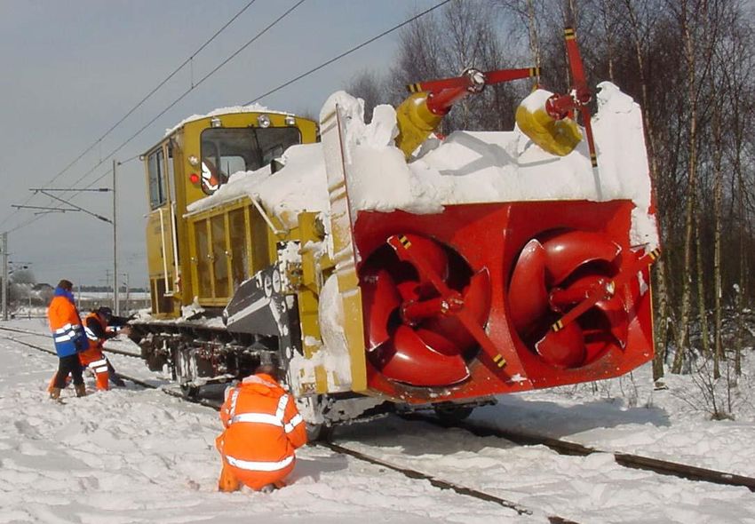
Scotland Route: WRCCA plan
The following sections provide findings from the Scotland Route vulnerability and impact
assessments, and details of the WRCCA actions; both completed and planned in Control
Strategy Period 5, and potential additional actions, that aim to increase weather and climate change
and policy resilience.
Adaptation Management Vulnerability
actions and review assessment
Impact
assessment
Figure 6 Weather resilience and climate change adaptation framework
Network Rail weather resilience and climate change adaptation actions will include a range
of measures appropriate to the strength of evidence and level of risk:
soft – changes to processes, standards and specifications, increasing knowledge and skill
base
hard – engineered solutions to increase resilience; e.g. raising of sea walls and increasing
drainage capacity Snow Avalanche near Tyndrum, February 2011
‘do nothing/minimum’ – the option to ‘do nothing’ or ‘do minimum’ should be evaluated
‘no regrets’ – measures that increase the resilience of the assets to current and future
impacts
precautionary – investment into adaptation measures today in anticipation of risk in the future
managed adaptive – a staged approach incorporating uncertainties in future risk and current
investment funds, allowing assets to be retrofitted cost-effectively in the future.
Network Rail 6
Scotland Route: WRCCA plan
Scotland Route WRCCA strategy
The Network Rail Sustainable Development Strategy outlines corporate weather resilience
and climate change adaptation objectives, and commits the business to:
understand our current weather resilience, and seek to optimise resilience and enhance
adaptation capability
develop a thorough understanding of the potential impacts of climate change in terms of
infrastructure performance, safety risks and costs
embed climate change adaptation within our asset policies and investment decisions
communicate the role that the rail network plays in supporting weather and climate
resilience across Great Britain, and support efforts to increase national resilience.
These objectives will support the long-term management of a weather resilient railway and
are fundamental steps towards achieving Network Rail’s sustainable development vision of
a railway fit for the future.
Scotland Route strategy
Scotland Route is committed to supporting the delivery of this strategy through Route-
specific weather resilience and climate change adaptation objectives:
increase the understanding of climate change impacts on the Scotland Route
improve the knowledge of weather impacts through identification of root causes and trends
to support the identification of cost effective resilience measures
develop and manage a Route Climate Change Adaptation Plan to inform current and
future Control Period investment plans and work banks
include climate change adaptation in Project Requirement Specifications for renewals and
new works
improve operational responses to extreme weather events
support initiatives and demonstration projects aiming to deliver network-wide resilience
improvements
engage with key regional stakeholders to communicate the Scotland Route strategy,
planned programmes of work and identified climate change adaptation actions, including
the Scotland Environment Protection Agency and Transport Scotland.
Through these objectives, Network Rail’s corporate commitments are applied in the context
of Scotland Route, supported by the opportunities to deal locally with challenges from a
changing regional climate. Meeting these objectives will contribute to the long-term
resilience and sustainability of Scotland Route and the whole railway network.
Flooding at Dalmuir, November 2009
Network Rail 7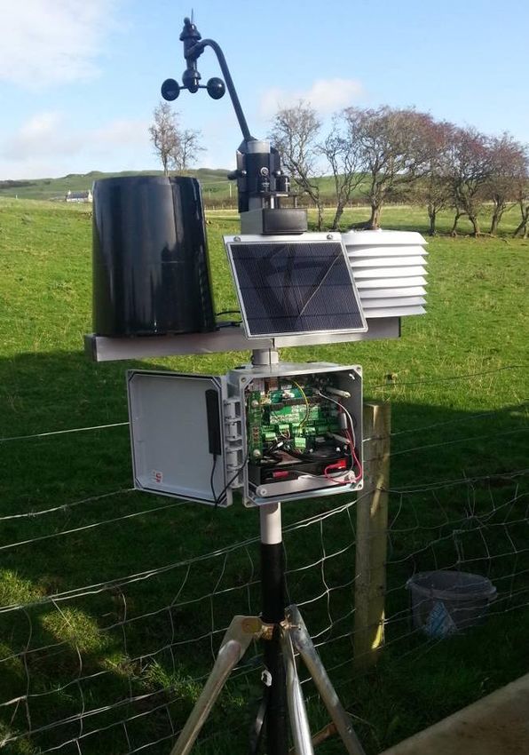
Scotland Route: WRCCA plan
Scotland Route vulnerability assessment
This section provides the details of the general vulnerability of the rail network in Great Britain
and Scotland Route’s specific vulnerabilities to weather impacts, and regional climate change
projections.
Network-wide weather vulnerability
The challenge for Network Rail is to manage a complex and extensive portfolio of assets, with
variations in geographic location, age, deterioration rates and vulnerability to weather impacts.
Continual analysis of the vulnerability of rail assets to weather, and identification of trends and
characteristics of weather-triggered failures, improves our knowledge of the resilience of the
rail network. An understanding of current weather impacts is an essential platform to implement
cost-effective investments to adapt the network to future changes in climate.
The whole rail network is sensitive and exposed in some way to many primary climate drivers
and secondary impacts, including:
temperature
rainfall
wind gusts Figure 7 Example of asset failure and weather analysis
flooding
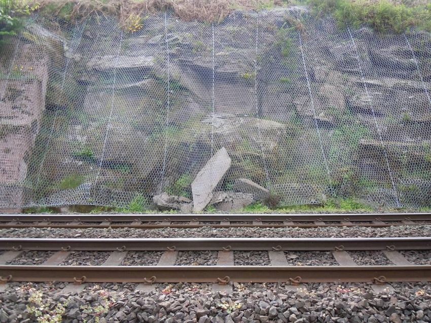
landslips Managing operational response to weather vulnerability
soil moisture
Network Rail manages risks from weather-related impacts through a range of asset
sea level rise
management tools, operational response standards and alert systems. Higher risk assets
coastal erosion.
are prioritised for investment within asset policies and proactively managed through
Network Rail has moved from subjective and expert review-based knowledge of weather risk-based maintenance.
and climate change risks to more detailed internal analysis of asset failure and weather data Defining ‘normal’, ‘adverse’ and ‘extreme’ weather conditions is fundamental to ensuring
to understand thresholds at which failure rates significantly change. Figure 7 provides an effective coordination across the rail-industry. Network Rail and the National Task Force
illustrative example of the analysis identifying assets with higher sensitivity to weather impacts. (a senior rail cross-industry representative group) are currently reviewing weather thresholds
The horizontal lines are thresholds where there is ‘no significant’ (green), ‘significant’ (amber) and definitions to improve the Extreme Weather Action Team (EWAT) process which manages
or ‘very significant’ change in incident rates (red). This deeper dive analysis is critical to train services during extreme weather alerts.
understanding the resilience of operational assets both today and potentially in future climates.
Control rooms monitor and respond to real-time weather alerts through a range of action plans.
From this analysis it has been established that high temperatures have wider impacts across Operational response to the risks posed by weather events includes: temporary speed
assets, low temperature affecting track asserts particularly points, earthworks are the restrictions (TSRs), deployment of staff to monitor the asset at risk, proactive management
predominant asset sensitive to rainfall and overhead line equipment (OLE) to wind gusts.
of the asset: i.e. use of ice patrols to remove ice from OLE or protection of assets from flood
Rail asset and weather impact relationships are complex, as demonstrated in the case of OLE water, and in some cases where the risk dictates, full closure of the line. Increasing the
where many wind-related failures are a result of vegetation incursion and not direct wind gusts resilience of the infrastructure reduces the need for operational response; however, the range
as the primary impact. Therefore any analysis of rail assets and weather vulnerability requires of weather events experienced today, potential changes in the future, and the prohibitive scale
deeper understanding of root causes to identify cost effective resilience actions. of investments required to mitigate all weather risks, means that operational response will
always be a critical process for Routes to manage safety risks.
Network Rail 8Scotland Route: WRCCA plan
Network Rail seeks continuous improvement of weather-based decision support tools, Scotland Route weather stations
including flood, temperature, wind speed and rainfall alerts. A trial aiming to significantly Improvements in our capability to receive weather forecasts and alerts in Scotland Route
improve real-time weather forecasting has installed 102 weather stations on the Scotland rail is being provided by the recently installed 102 weather stations, Figure 9, around the route on
network, Figure 8. The pilot study is currently being evaluated to support a potential wider roll- GSM-R Masts, lineside cabinets, lineside buildings and on the Forth Bridge and the Tay
out of this level of weather service. Bridge.
There were a number of drivers for this initiative:
Office of Rail Regulation and Rail Accident Investigation Branch recommendations
knowledge of vulnerable assets could be improved
reduction of weather-related risk.
The aims of installing the weather stations were:
improved asset resilience during poor weather conditions
improved network performance
improved safety
improved stakeholder relations
improved design of renewals/enhancements.
Computer analysis of trends and statistics enables decisions to be made based on scientific
fact rather than experience or intuition. The weather stations will help develop accurate
forecasting which allows proactive and risk-based decisions for network operations. However,
in order to analyse data, we must first collect as much as we can.
Figure 8 Scotland Route real-time weather monitor
For the management of operational flooding risk, Network Rail receives alerts through our
Flood Warning database. In locations where no national flood warnings are available, Network
Rail can arrange to receive alerts from bespoke river level monitoring equipment.
Longer-term flood risk management of rail assets is provided through geographic information
system (GIS) decision support tools including flood datasets, such as Network Rail’s Washout
and Earthflow Risk Mapping tool (WERM). Transformative asset information programmes are
currently aiming to improve weather-related hazard mapping in decision support tools.
Network Rail 9Scotland Route: WRCCA plan
Improving our network-wide resilience
A Weather Resilience and Climate Change (WRCC) programme is at the centre of Network
Rail’s delivery plans. Its importance is underlined by the fact that it is one of the Company’s top
15 business change projects. The programme was first identified in April 2013, but its priority
and profile were heightened as a result of the extreme weather that was experienced between
October 2013 and March 2014. The programme board and stakeholders include
representatives from across the rail industry.
The WRCC programme is founded on a bow tie risk assessment of weather-related disruption,
Figure 10 – this risk assessment methodology is used widely across Network Rail. The bow tie
assessment provides a detailed understanding of the adequacy of the controls that are in place
to reduce the causes of disruption and consequences and highlights those controls that need
to be enhanced.
Figure 10 Bow tie risk assessment
The programme consists of six sub-programmes and their 23 constituent projects; these are
described in Figure 11 below. Although the bulk of the outcomes that are currently defined
expect to be delivered within the next 18 months, the programme is expected to extend
throughout CP5.
It is important to emphasise the national-level programme supplements the work Routes are
completing under their CP5 business plans.
Figure 9 One of the 102 weather stations deployed around Scotland Route
Network Rail 10Scotland Route: WRCCA plan
Route weather vulnerability
WWRCC Sub-Programmes
The geography of Scotland is highly varied, from rural lowlands to barren uplands and from
large cities to rural communities. The topography of Scotland is distinguished by the Highland
Infrastructure Cross-industry Earthworks Boundary Fault which traverses the Scottish mainland from Helensburgh to Stonehaven.
1 2 3
Resilience Resilience Integrity
This fault line separates two distinctively different regions: namely the Highlands to the north
1. Year 1 Enhanced vegetation 8. Property portfolio 12. Improved Earthworks and west and the lowlands to the south and east. The more rugged Highland region contains
management strategy 9. Fleet Knowledge
2. Sustainable vegetation 10. Timetabling-flexibility and 13. Improved Drainage the majority of Scotland's mountainous terrain, which in itself is difficult to manage a large and
strategy contingency planning Knowledge and Management exposed railway network, marry this with the abundance of rainfall we receive in Scotland and
3. Identifying Highest Risk 11. Providing advice and 14. Improved Earthworks
assets Enhanced resilience communicating with Monitoring
it makes for a challenging environment.
to effects of: customers 15. Improved Earthworks
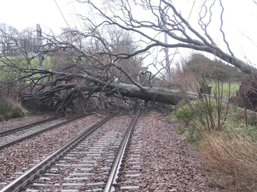
4. Flooding Management Wind remains the primary vulnerability within the route, accounting for 28 per cent of the route
5. Costal surge delay costs during 2006-2014. The vast majority of wind-related delay incidents are not wind
6. Snow, Ice and extreme gust affecting the OLE, more often than not its objects being blown on to the line and in some
temperatures
7. High winds cases hitting the OLE and taking out a section.
In recent years we have had to deal with multiple third-party intrusion on OLE in periods of high
National Weather Climate Change Information
4 5 6 winds with various articles blowing on to the line around Scotland Route, including trampolines,
Event Response Adaptation Exploitation
balloons, polythene sheets and garden sheds.
16. Weather Definitions and 20. Route Climate Change 22. Delivering supplementary
Thresholds Adaptation Plans information With further extension in the number of electrified routes in Scotland wind will continue to be
17. Weather Event Response 21. Tomorrow’s Railway & 23. Delivering Weather Resilience
18. Weather Information and Climate Change Adaptation Intelligence our number one priority.
Decision Support systems project
19. Strategic resource Scotland Route is also vulnerable to the effects of heavy rainfall with flooding accounting for
management 23.6 per cent of delay minutes 2006/07 to 2013/14.
Figure 11 The constituent components of Network Rail’s WRCC programme Scotland Route has established plans to mitigate the effects of these weather impacts and
continues to work proactively to further improve resilience.
The WRCC programme is currently supporting the delivery of:
an enhanced vegetation management project: £10M of accelerated funding to address high Winter weather risk preparedness
risk trees and mitigate the impact of both extreme winds and adhesion issues Problems in Scotland Route are low adhesion to compacted snow and ice, icing of OLE, ice
points enhancements: Installation of up to 7,000 points heat insulation and covers in support on inside of tunnels, snow in the points, landslips, flooding and strong winds.
of Key Route Strategy
Scotland Route has a procedure for proactively maintaining the infrastructure during winter
forensic investigation of earthworks failures in 2012/13 and 2013/14: The 261 failures that
months (Scotland Route: Winter Working Arrangements), which includes prompt reporting of
occurred during this two year period have been investigated with Deep Dive analysis being
infrastructure failures due to the weather conditions and coordinating local actions for
undertaken on 89 of them.
maintenance staff reporting to sites. Improvement included the ability to remotely switch on
earthworks remote condition monitoring pilot: Involving 250 high risk sites across four Routes
90 per cent of points heaters across the route without attending site and visiting the worst
(Scotland, LNE, Wessex and Western) starting in December 2014.
affected wire runs each morning during severe cold.
improved drainage management: mobile works tools and drainage competency
improvements by December 2014 The Route also has four snowploughs, Figure 12, available along with two snow blowers,
agreed weather thresholds and definitions. Figure 14, together with miniature snowploughs/route proving locos hired and stabled at
an enhanced extreme weather action team process: This will be reviewed and the improved various locations as dictated by the weather forecast.
processes implemented into the first Route by end November 2014
aerial surveys of infrastructure using the Light Detecting and Ranging (LIDAR) technique;
This will be complete by December 2014
enhanced weather forecast service which will be in use from April 2015.
Network Rail 11Scotland Route: WRCCA plan
Figure 12 Snowploughs are based at Slateford, Mossend, Inverness and Carlisle Figure 13 Winter train located at Slateford
The Snow Train or ‘Winter Development Vehicle’ as it is known, Figure 13, has been modified
Winter preparedness for staff
to carry the modules, generator and hot air blowers and a Mark 2 British Rail ex-Radio Survey
The 2009/10, 2010/11 and 2013/14 winter seasons posed some of the most severe winter
Coach (with camera monitors, remote controls, GPS system installed etc). It was first
conditions for Scotland Route staff to work in. This included difficulty for signallers getting to
introduced to the Route (and the company) in Winter 2011/12 at a cost of £1.4m.
work, maintenance staff responding to incidents and staff working in sub-zero temperatures for
It is used to melt snow from sets of points and has been used at Midcalder Jn, Lanark Jn and long hours over a period of up to four months to assist in keeping the railway running.
Law Jn. The train has the ability to sit over a set of points and blow warm air on to these,
As a result, several actions have been put in place to ensure if there is a severe winter the
melting the snow and drying the points out. It also has steam lances and compressed air
Route will be better equipped to deal with staff and welfare issues. Staff working in any winter
lances so the operators can clear the snow with more precision than the fixed hot air blower. It
conditions should always report at regular intervals to Scotland Infrastructure Control Centre
can be used on any line of Route within Scotland to clear/defrost points and can also be
(ICC) especially when working alone at remote locations.
coupled with any of the snowploughs to provide a ‘one stop shop’ winter train.
In particular, arrangements have been put in place for both lone workers on the railway and
signallers working in remote areas as the safety risks faced by lone workers on the railway
increases significantly during the winter season, especially during severe weather conditions.
Network Rail 12Scotland Route: WRCCA plan
Summer weather risk preparedness
Scotland Route doesn’t suffer from a lot of heat-related problems; however we still take actions
to ensure that potential problems do not arise.
The onset of summer brings with it a number of risks to the effective operation of the rail
network. The main risks are:
expansion of point work causing detection failures
closure of Intermediate Block Joints (IBJ) causing track circuit failures
air conditioning failure
heat effect on overhead line equipment
flooding
lightning strikes on the infrastructure
rail buckles due to high temperatures
staff working in outside locations experiencing sun exposure.
Scotland Route has a procedure (Scotland Route Summer Work Arrangements) for proactively
maintaining the infrastructure during summer and periods of hot weather; this is documented
and reviewed annually.
Scotland Route also priorities low CRT sites to ensure as few locations as possible on main
running lines require a CRT imposed on the hottest of days and weekly progress report on
summer preparedness (plate oiling, fish plate adjusting, CRTs, etc) is sent to relevant parties
to highlight any issues. The painting of rails white is a mitigation action to reduce high
temperature effects on points, Figure 15.
All of these actions help to ensure if the temperature does increase to a particular dangerous
level the Scotland route has already mitigated some of the potential issues.
Figure 14 Two snow blowers are located at Kilmarnock and Inverness
Network Rail 13Scotland Route: WRCCA plan
Future climate change vulnerability
The relationship between weather events and climate is complex; therefore it is
understandable that climate change projections do not forecast future weather events.
However, Network Rail can use the climate projections to understand potential risks and make
informed strategic decisions to increase future weather resilience.
The UK Climate Change Projections (UKCP09) provides regional climate change projections
across 13 administrative regions in Great Britain, Figure 16. Scotland Route is divided into
three regions – Western Scotland, Eastern Scotland and Northern Scotland. Projections for
these are considered to be representative of the future climate changes within the Route.
Figure 15 Rails painted white to reduce heat effects on points, Glasgow Central Station Figure 16 UKCP09 administrative regions
Network Rail 14Scotland Route: WRCCA plan
The following derived charts from UKCP09 data show the projected changes in temperature 4
and precipitation for the high emissions scenario, 50th percentile (10th and 90th percentile data
has been obtained). The projected changes are shown for future climate periods up to the 3.5
2080s (2070-2099) and are relative to the baseline climate of 1970s (1961-1990). 2080s
Temperature Change (°C)
3
2070s
Mean daily maximum temperature change 2.5
Mean daily maximum temperatures for all parts of Scotland are projected to increase 2060s
throughout the year, with greater increases expected in the summer months. 2
2050s
In Eastern Scotland the average maximum daily temperature in July is expected to increase 1.5 2040s
by 2.6°C, reaching 19.6°C by the 2050s, and by 4.3°C, reaching 21.3°C by the 2080s. Average
maximum daily temperature in January is expected to increase by 1.8°C, reaching 6.1°C by the 1 2030s
2050s, and by 2.5°C, reaching 6.8°C by the 2080s, Figure 17.
0.5 2020s
5
0
4.5 Jan Feb Mar Apr May Jun Jul Aug Sep Oct Nov Dec
4 2080s
Temperature Change (°C)
3.5 Figure 18 Scotland North, mean max temperature change (50th percentile)
2070s
3 The average maximum daily temperature in Western Scotland in July is expected to increase
2060s
2.5 by 2.2°C, reaching 19°C by the 2050s, and by 3.7°C, reaching 20.5°C by the 2080s. Average
2050s maximum daily temperature in January is expected to increase by 1.9°C, reaching 7.2°C by
2 the 2050s, and by 2.8°C, reaching 8.1°C by the 2080s, Figure 19.
2040s
1.5
2030s 4.5
1
2020s 4
0.5
2080s
Temperature Change (°C)
0 3.5
Jan Feb Mar Apr May Jun Jul Aug Sep Oct Nov Dec 3 2070s
2.5 2060s
Figure 17 Scotland East, mean max temperature change (50th percentile)
2 2050s
The average maximum daily temperature in Northern Scotland in July is expected to increase
by 2.1°C, reaching 17.6°C by the 2050s, and by 3.5°C, reaching 19°C by the 2080s. Average 1.5 2040s
maximum daily temperature in January is expected to increase by 1.7°C, reaching 6.3°C by 1 2030s
the 2050s, and by 2.3°C, reaching 6.9°C by the 2080s, Figure 18.
0.5 2020s
0
Jan Feb Mar Apr May Jun Jul Aug Sep Oct Nov Dec
Figure 19 Scotland West, mean max temperature change (50th percentile)
Network Rail 15Scotland Route: WRCCA plan
Mean daily minimum temperature change 4
The mean daily minimum temperatures for all parts of Scotland are also projected to increase
throughout the year. 3.5
2080s
Temperature Change (°C)
In Eastern Scotland the average minimum daily temperature in July is projected to increase 3
by 2.6°C, reaching 11.7°C by 2050s, and by 4.2°C reaching 13.3°C by the 2080s. Average 2070s
minimum daily temperature in January is projected to increase by 1.9°C, reaching 1.2°C by 2.5
2060s
2050s, and by 2.6°C, reaching 1.9°C by 2080s, Figure 20.
2
2050s
4.5
1.5 2040s
4
1 2030s
2080s
Temperature Change (°C)
3.5
0.5 2020s
3 2070s
2060s 0
2.5
Jan Feb Mar Apr May Jun Jul Aug Sep Oct Nov Dec
2 2050s
1.5 2040s Figure 21 Scotland North, mean min temperature change (50th percentile)
1 2030s In Western Scotland the average minimum daily temperature in July is projected to increase
2020s by 2.4°C, reaching 12.2°C by 2050s, and by 3.8°C reaching 13.7°C by the 2080s. Average
0.5
minimum daily temperature in January is projected to increase by 2.4°C, reaching 2.9°C
0 by 2050s, and by 3.5°C, reaching 4°C by 2080s, Figure 22.
Jan Feb Mar Apr May Jun Jul Aug Sep Oct Nov Dec
4.5
Figure 20 Scotland East, mean min temperature change (50th percentile) 4
2080s
Temperature Change (°C)
In Northern Scotland the average minimum daily temperature in July is projected to increase 3.5
by 2.3°C, reaching 11.3°C by 2050s, and by 3.8°C reaching 12.8°C by the 2080s. Average 3 2070s
minimum daily temperature in January is projected to increase by 1.8°C, reaching 1.7°C by
2050s, and by 2.4°C, reaching 2.3°C by 2080s, Figure 21. 2.5 2060s
2 2050s
1.5 2040s
1 2030s
0.5 2020s
0
Jan Feb Mar Apr May Jun Jul Aug Sep Oct Nov Dec
Figure 22 Scotland West, mean min temperature change (50th percentile)
Network Rail 16Scotland Route: WRCCA plan
Mean daily precipitation 50
Projections for mean daily precipitation for all parts of Scotland show a significant increase
in the winter months and a decrease in summer months. 40
Daily Precipitation Change (%)
2080s
In Eastern Scotland the greatest increase in daily precipitation is expected to occur in
November. Precipitation is projected to increase by 15 per cent, reaching 4.2mm per day 30 2070s
by the 2050s, and by 23 per cent, reaching 4.5mm per day by the 2080s. The month with
2060s
the greatest decrease in precipitation is likely to be June, when daily precipitation is projected 20
to decrease by 17 per cent by the 2050s, to 1.9mm per day, and by 25 per cent, to 1.7mm per 2050s
day by the 2080s, Figure 23. 10
2040s
30 0 2030s
Jan Feb Mar Apr May Jun Jul Aug Sep Oct Nov Dec 2020s
20 -10
Daily Precipitation Change (%)
2080s
2070s -20
10
2060s Figure 24 Scotland North, mean daily precipitation change (50th percentile)
0 2050s In Western Scotland the greatest increase in precipitation is expected to occur in December.
Jan Feb Mar Apr May Jun Jul Aug Sep Oct Nov Dec The mean daily precipitation is projected to increase by 20 per cent, reaching 7.3mm per day
2040s
-10 by the 2050s, and by 40 per cent, reaching 8.5mm per day by the 2080s. Similar to Eastern
2030s Scotland, here the greatest reduction is also likely to occur in June, when the mean daily
2020s precipitation is projected to decrease by 16 per cent by the 2050s, to 2.4mm per day, and by
-20 24 per cent, to 2.2mm per day by the 2080s, Figure 25.
50
-30
40
Daily Precipitation Change (%)
Figure 23 Scotland East, mean daily precipitation change (50th percentile) 2080s
30
2070s
In Northern Scotland the greatest increase in precipitation is expected to occur in December.
The mean daily precipitation is projected to increase by 20 per cent, reaching 7mm per day 20 2060s
by the 2050s, and by 40 per cent, reaching 8.1mm per day by the 2080s. The greatest
10 2050s
reduction is likely to occur in August, when the mean daily precipitation is projected to
decrease by 7 per cent by the 2050s, to 3.1mm per day, and by 11 per cent, to 2.9mm per day 0 2040s
by the 2080s, Figure 24. Jan Feb Mar Apr May Jun Jul Aug Sep Oct Nov Dec 2030s
-10
2020s
-20
-30
Figure 25 Scotland West, mean daily precipitation change (50th percentile)
Network Rail 17Scotland Route: WRCCA plan Sea level rise Sea level rise for the Scotland Route coastal and estuarine assets can be represented by the projections for the Queensferry area. For the high emissions scenario, the projections for the 50th percentile for 2050 are 0.176m and 0.413m by the end of century (the rise is unlikely to be higher than 0.319m and 0.735m respectively), Figure 26. The increase in sea level will have to be considered in any future design. Figure 26 UKCP09 sea level rise projections for Queensferry area The understanding of the vulnerability of Scotland Route rail assets to current weather and potential risks from future climate change is an important stage in developing WRCCA actions. Network Rail 18
Scotland Route: WRCCA plan
Scotland Route impact assessment
This section provides the findings from the Scotland Route weather impact assessment, Over the past eight years, the average annual performance cost to the Scotland route, as a
including annual performance impacts and identification of high impact locations on the Route. result of weather-related events, has been almost £5m.
The analysis shows that wind, flooding and snow have been the most significant weather
Performance impacts
impacts for the Route. Climate modelling cannot provide strong projections for future changes
The impact of weather on the rail network can be monitored within rail performance data.
to wind speeds, though; increased storm frequency is generally projected and may increase
Schedule 8 costs, the compensation payments to train and freight operators for network
the risk of wind-related incidents on the Route.
disruption, are used as a proxy for weather impacts due to greater granularity of root cause
reporting. Table 1 Prioritisation of weather-related impacts on Scotland Route
Weather-
Schedule 8 costs for the past eight financial years for the Scotland Route has been analysed
related Schedule 8
to provide an assessment of weather impacts, Figure 27. impact costs1 Projected future impacts Prioritisation
‘flooding’ costs include delays due to a range of fluvial, pluvial, groundwater and tidal Wind £0.99m Wind changes difficult to project however generally High
flooding of assets projected to increase
‘earthslip’ delays have been included due to internal analysis indicating primary triggers Flooding £0.91m Up to 25 per cent increase in February mean daily High
of earthworks failures are weather-related precipitation2
‘heat’ and ‘wind’ include direct impacts on assets and impacts on delay due to speed Snow £0.98m Up to 3oC increase in January mean daily minimum Medium
restrictions implemented as part of Network Rail’s operational response during weather temperature1
events.
Adhesion £0.16m Complex relationship between adhesion issues and Medium
£12 future climate change.
Millions
Earthslips £0.25m Up to 25 per cent increase in February mean daily Medium
£10 Adhesion precipitation1
Cold Heat £0.02m Up to 3.1oC increase in July mean daily maximum Medium
£8 temperature2
Flood
Sea level rise Not recorded 0.18m increase in sea level rise3 Medium
Lightning Cold £0.22m Up to 3oC increase in January mean daily minimum Low
£6
Snow temperature2
£4 Wind Lightning £0.20m Storm changes difficult to project however generally Low
projected to increase
Earthslip Fog 2 mins delay Complex relationship; however, research suggests Low
£2
Heat fog events may decrease
£0 Fog 1 Annual average 2006/07 to 2013/14,
2 UKCP09 projection, 2050s High emissions scenario, 50th percentile, against 1970s baseline
Scotland 3 UKCP09 projection, 2050s High emissions scenario, 50th percentile, against 1990 baseline
Snow-related delays have been significant but are projected to decrease in the future.
However, extreme cold-related events are projected to continue to occur and actions to ensure
resilience to cold-related weather impacts should continue to be factored in future seasonal
Figure 27 Scotland Route weather attributed Schedule 8 costs 2006/07-2013/14 preparedness and investment decisions.
Network Rail 19Scotland Route: WRCCA plan
The impacts of changes in winter and summer precipitation on flooding patterns are complex; Identification of higher risk locations
however, it is expected that flooding events will increase in frequency and intensity, and A geographic information system (GIS) based decision support tool, METEX, has been
presents increased risk to the Scotland Route over the coming decades. developed to analyse gridded observed weather data and rail data, including the past eight
years of delays attributed to weather.
A combination of the analysis of weather impacts on the Scotland Route and regional climate
change vulnerability from UKCP09 can be used to prioritise weather resilience actions. Over recent years our network has experienced some of the most extreme weather on record
and weaknesses in existing assets will be captured in performance impacts. Climate change is
It is also worth noting the Schedule 8 cost per delay minute in CP5 will be on average
projected to impact the UK with more intense and frequent extreme weather events, so taking
60 per cent higher, further reinforcing the importance of effective WRCCA actions.
actions on our current weaknesses, and proactively managing future risks are important steps
to increasing our future resilience.
Higher-risk locations have been identified by assessing METEX outputs for high-frequency/
high-cost sites across the whole Route, and detailed assessment of key sections of the rail
network. These locations have been assessed to determine:
validity of the delay attribution to a weather impact
root cause of the delay
resilience actions that have been undertaken
resilience actions that are currently planned
identification and prioritisation of additional resilience actions.
In addition, Routes have identified potential future risks and resilience actions based on climate
change projections and Route knowledge.
Tree on the line affecting OLE, Ardoch, January 2013, following a cyclone
Network Rail 20Scotland Route: WRCCA plan
Wind impact assessment
Based on 2006/07 to 2013/14 data, wind-related delays total 56,106 minutes per year, costing
£0.99m per year in Schedule 8 costs. This is 28.5 per cent of weather-related delay minutes.
The following table is a list of our top ten most costly sites and the number of incidents we
responded to over period 2006/07-2013/14 as a direct result of high winds.
Location No. of incidents
Rutherglen East Jn 4
Drem to Dunbar 14
Lockerbie to Gretna Jn 1
Saltcoats 21
Anniesland 2
Winchburgh Jn 5
Gourock Station 1
Craigendoran Jn 7
Gailes 7
Dyce 4
Figure 28 Hay bales on line just North of Newtonhill, Aberdeenshire, December 2013
Wind affects performance directly in that blanket speed restrictions are imposed when
thresholds are reached. Scotland Route has a High Wind Procedure involving live feeds
Vegetation
from weather stations and predefined trigger levels for wind gusts of 60mph+ or mean speed
The Route has commenced a proactive strategy to remove high-risk trees which are capable
of 47mph+.
of landing on the track if they fall. Clearing trees in danger of falling on or near the line is an
Wind also affects performance indirectly, primarily as a result of damaging lineside trees which enormous undertaking with some trees protected and other trees forming an important visual
then fall or drop branches on or near the line. Wind also moves other debris on to the line from screen to our infrastructure.
the line side environment, frequently from neighbouring sites, recent examples include
A LIDAR (Light Detection and Ranging) survey was undertaken in July 2012 to identify trees
trampolines, balloons, polythene sheets and garden sheds, Figure 28.
that were at risk of falling on to our infrastructure. It also provided data on the height of the tree
High winds can also lead to significant waves to form even in waters protected from the open and where the trees are growing, for example an embankment or cuttings. A further LIDAR
sea, these can cause power trips in OLE areas and damage to the infrastructure. survey is been undertaken this year which will also give us increased details of the trees that
are remaining, the results from this survey, available in Spring 2015, will be used by the Route
A recent example of the effects of wind on Scotland route occurred on 4 December 2013.
to target the areas at which the railway appears to be vulnerable.
An advanced weather warning was issued to media outlets in Scotland, stating that on the
morning of 5 December, due to forecast high winds, the rail network would be closed for much Where it is not possible to remove a tree completely, work is undertaken to reduce the
of the day. On one particular part of the rail network in Markinch, Fife, over 60 large trees fell crown size.
on the railway completely blocking the line until operatives could get on site and clear the
In addition, improvements to Asset Resilience and Vegetation Management will include:
debris. The rail network started to re-open in the early afternoon in some parts of the Route.
development of vegetation encroachment risk model and risk-based prioritised vegetation
Closing the rail network for that one day due to high winds cost Network Rail over £1m in delay
management plans are now in place
attribution cost.
enhanced management process for trees in high winds introduced in the Route underpinned
by real time weather stations.
Network Rail 21Scotland Route: WRCCA plan
Water Management Group
Since 2008 Scotland Route has held a period end Water Management Group to look at flood
sites and to plan actions to mitigate flooding. This group has led to the mitigation of minor and
major flood sites within the Route.
The following table is a list of sites which, in recent years, have been greatly affected by
flooding and work done to mitigate against any future flooding at the sites and reduce the
number of delay minutes to passengers.
Sites Action details When
Dalmuir Mitigated through minor works and sewer repairs by Scottish Ongoing
Water. Future works to increase resilience is planned during
CP5
Glasgow Queen Mitigated through a number of minor improvements together Completed
Street with enhanced inspection and maintenance
Princes St. Gardens Flooding in Princes St. Gardens was remediated by a major Completed
works scheme to gather and pump the water away
Penmanshiel Flood site at Penmanshiel siphon. Initial remediation through Ongoing
enhanced inspection and cleaning. A major works scheme to
raise the wall heads of siphon chamber and install new
screens has being completed. Further enhancement to
provide an attenuation pond is planned during CP5
Dalmarnock Station Flood site at Dalmarnock Station remediated through major Completed
works by providing an attenuation system
Plean Flood site at Plean/Cowie remediated by a major works Completed
scheme with new culvert
Winchburgh Jn Five flood sites in the greater Winchburgh area over 4 miles Ongoing
Figure 29 High winds cause considerable damage to trains, Dunkeld and Burnam of track. First Phase mitigation completed by replacing pipes
which were under capacity in Craigton cutting and renewing
pipe work at Winchburgh Junction. A second phase to
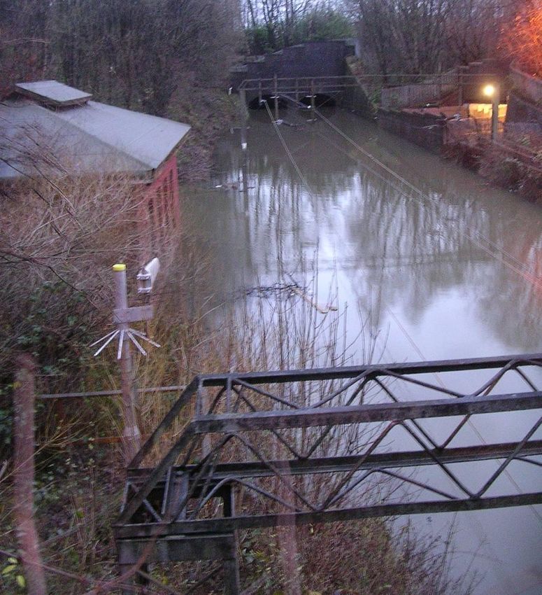
Flooding impact assessment
replace the Underbridge at Niddrie Burn, works at Swine
Based on 2006/07 to 2013/14 data, flood-related delays total 46,444 minutes per year on Burn Pumping Station and install new track drainage is
average, costing £0.91m per year in Schedule 8 costs. This is 23.6 per cent of weather-related planned during CP5
delay minutes.
Wallyford Flood site at Wallyford where a culvert screen blocked and Completed
Scotland has experienced high levels of rainfall since the start of 2008, three of the top 10 flows went on to the track. New more resilience screen
rainfall years in the last 100 years have occurred since then. designed and installed
Drem Flood site at Drem station which has been remediated under Completed
Average annual rainfall in Scotland, since records began in 1910 is 1433mm but both 2011/12
a Business Plan with a new pipe work and an attenuation
and 2013/14 were well above that level. pond
2011/12 saw 1827mm, the third wettest since 1910, with 2013/14 at 1738mm. Lochwinnoch Minor works completed at Milliken Park and Lochwinnoch Ongoing
Station. Enhanced inspection and maintenance ongoing with
The calendar year 2011 was the wettest year of the last 100 with 2008 in fourth place and 2009 further minor works planned during CP5
in eighth place.
Network Rail 22Scotland Route: WRCCA plan
Track assets
Flooding can greatly affect the Track and its formation. There are a number of investigations
Scotland Route is proposing to undertake in order to better understand the impact of flooding
on the Track system:
ballast retention – in areas of high flood potential investigate means of ballast retention
to avoid loss of track formation as a result of wash out or scour
investigate use of bituminous paving materials on sub grade to improve water run off and
avoid scour or earthworks failure
ballast cleaning/replacement – model the probability of increased ballast fouling as a result
of regular flooding or increased rainfall, leading to reduced ballast life. In critical locations
outline what ballast replacement frequencies or methodology should be adopted .
Structures assets
The topography of the Route, with steep-sided mountainous terrain and high rainfall, together
with other significant precursors such as seasonal snow melt and sudden release of water from
hydroelectric scheme dams means that our assets are particularly susceptible to severe
localised weather events, as well as wider floodplain events.
Scotland Route contains a larger proportion of small diameter culverts on steep sidelong
ground than other routes. As a result, the route has an increased work bank of culvert repairs
identified in addition to those identified by the Network Rail Structures Policy.
The West Highland Line is a section of route with a significant number of such assets in poor
condition, and at risk of increased frequency of severe weather events. A specific asset
strategy has been developed and a remediation programme has commenced continuing
through to the end of CP6.
Due to their small size, culverts can also present constraints in flow capacity when considered
as part of an overall drainage system. During periods of exceptional rainfall this can lead to
overtopping of these assets or flooding of adjacent land.
Two culverts with multiple historic instances of flooding have been identified by the Route
Water Management Group for replacement. For example, the replacement of the culvert
Figure 30 Flooding at Bishopton, August 2012 crossing Keppen Burn, Figure 31, on the Kilwinning Jn to Largs Line at Fairlie is being jointly
developed with Transport Scotland (Trunk Roads Directorate) and North Ayrshire Council to
Increasingly frequent and intense storms may have the effect of overwhelming the existing
provide the optimum solution.
drainage networks. This in turn could lead to service disruption and accelerated degradation
of other assets that depend on good drainage, for example geotechnical assets and the track
formation.
A recent example of this was 12 August 2014, at Kingussie when heavy rainfall caused local
rivers to flood and drainage systems to become overwhelmed. Restoration of services took
three days whilst recovery operations took place to reinstate ballast washouts and clear flood
debris from the line. This one event caused 761 delay minutes and cost over £150,000 in delay
attribution costs.
Network Rail 23Scotland Route: WRCCA plan
To address the risk of overtopping at two historically at risk sites, schemes to improve the flow
capacity are proposed.
The replacement of the underbridge crossing the Niddrie Burn, Figure 32, on the Edinburgh
Waverley to Glasgow Queen Street Line would benefit from additional investment.
By replacing the existing two-span structure by a single-span structure, the flow capacity can
be increased to reduce the frequency of flooding and to be able to accommodate additional
pumped flows from the upgraded track/tunnel drainage system. The opportunity to carry out
this work is available in 2015/16 during the blockade to carry out work in Winchburgh Tunnel
as part of the Edinburgh to Glasgow Improvement Programme (EGIP) Enhancement Scheme.
Figure 31 Keppen Burn – downstream elevation
Figure 32 Niddrie Burn – downstream elevation
Underbridges
Underbridges historically experience scour and overtopping, which present a risk to the At Wamphray on the West Coast Main Line flow capacity is being increased by lowering
operation of the railway. the river bed (renewal of existing concrete weir), this scheme is also replacing damaged
scour protection.
We have an established programme to calculate the risk of scour damaging underbridges.
This programme is used to prioritise mitigation measures including physical works (scour Where full renewal of a bridge or culvert cannot be achieved, Scotland Route has explored a
protection) and operational instructions. number of alternative options to improve resilience to flooding. One example is at the bridges
crossing the Gynack and Balavil Burns near Kingussie on the Highland line, Figure 33. These
The Route currently has 41 structures classified as higher risk. In addition, a further 72
bridges have special operating instructions to allow trains to continue to run safely when river
structures have the potential to fall into the higher-risk category on the conclusion of more
levels are high and have scour protection and holding down arrangements installed to prevent
detailed assessment.
them being washed away.
The Route currently has plans to remediate 20 higher-risk sites in CP5. To further improve
weather resilience an additional 12 sites have been identified.
Network Rail 24Scotland Route: WRCCA plan
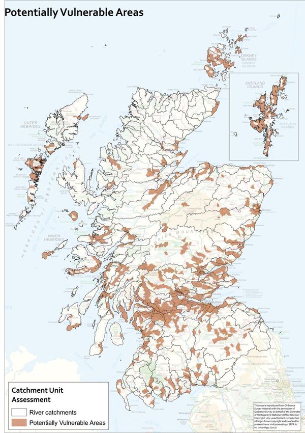
Potentially vulnerable areas
Scotland is developing its first Flood Risk Management Strategies, to be published by Scottish
Environment Protection Agency (SEPA) in 2015, and Local Flood Risk Management Plans,
published by Local Authorities in 2016.
SEPA’s approach to Flood Risk Management Planning is underpinned by the National Flood
Risk Assessment. This provided the first national picture of flood risk which looked at flooding
from rivers, the sea and heavy rainfall in urban areas. It identified 243 areas, called Potentially
Vulnerable Areas (PVAs), which contain the greatest risks from flooding in Scotland.
Scotland Route has one or more railways in 131 of these PVAs and will undertake a study of
each PVA to determine the risk to the railway. The 131 PVAs will be ranked based on the level
of risk to support long-term strategic flood resilience actions.
Scotland Route, along with all other Routes, is developing Drainage Management Plans during
CP5 to align with the above.
A high-level strategy has been developed for the production of these plans and a pilot study
has been undertaken on part of the Edinburgh to Glasgow main line, between Polmont and
Haymarket West Junction.
Figure 33 Gynack Burn, Kingussie – August 2014
Network Rail 25You can also read